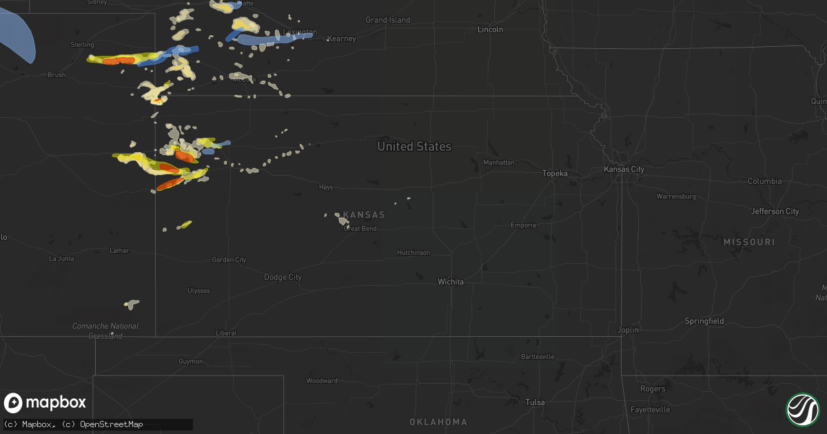
Hail Map in Kansas on July 13, 2020
Get this storm
July 13 map
$229
one time, instant access
Download today. No call, no setup
Keep the $229
Bought the map and want the full workflow? Apply the entire $229 to a subscription within 7 days. None of it is wasted.
Every map, not just this one
This buys you this map. Subscription and you get every map we run, in the markets you choose from a few cities to whole states to nationwide. Plus real-time alerts the moment a storm fires.
Contact data
Name, contact info, occupancy, even credit band for addresses in the footprint. You go from where it hit to who to call.
Become the source they trust
Unlimited branding weather history reports on demand. You already have the documented answer ready for the property owner, and you are the one who showed up with it.
Property data and RoofTrace estimates
Pull up any address you have got, its value and the exact code rules for that jurisdiction, straight from One Click Code. Then RoofTrace estimates the squares, pitch, and roof value, priced the way you price.
Storm reports in Kansas
Kansas
| Date | Description |
|---|---|
| 07/13/20206:20 AM CDT | At 1120 PM CDT, a severe thunderstorm was located 8 miles southwest of Grinnell, moving east at 20 mph. HAZARD...60 mph wind gusts and quarter size hail. SOURCE...Radar indicated. IMPACT...Hail damage to vehicles is expected. Expect wind damage to roofs, siding, and trees. Locations impacted include... Oakley, Quinter, Grainfield, Grinnell, Gove and Park. This includes Interstate 70 in Kansas between mile markers 76 and113. |
| 07/13/20206:13 AM CDT | At 1113 PM CDT, severe thunderstorms were located along a line extending from near Holbrook to near Hendley to 8 miles southeast of Wilsonville, moving east at 30 mph. HAZARD...60 mph wind gusts. SOURCE...Radar indicated. IMPACT...Expect damage to roofs, siding, and trees. Locations impacted include... Cambridge, Arapahoe, Oxford, Beaver City, Holbrook, Edison, Wilsonville, Hendley and Hollinger. |
| 07/13/20205:43 AM CDT | At 1042 PM MDT/1142 PM CDT/, a severe thunderstorm was located 11 miles south of Brewster, moving southeast at 30 mph. HAZARD...Two inch hail and 60 mph wind gusts. SOURCE...Radar indicated. IMPACT...People and animals outdoors will be injured. Expect hail damage to roofs, siding, windows, and vehicles. Expect wind damage to roofs, siding, and trees. Locations impacted include... Oakley, Winona and Monument. This includes Interstate 70 in Kansas between mile markers 33 and 35,and between mile markers 66 and 75. |
| 07/13/20205:36 AM CDT | At 1034 PM CDT, severe thunderstorms were located along a line extending from near Overton to near Holbrook to 9 miles west of Danbury, moving east at 35 mph. HAZARD...70 mph wind gusts. SOURCE...Radar indicated. IMPACT...Expect considerable tree damage. Damage is likely to mobile homes, roofs, and outbuildings. Locations impacted include... Cambridge, Arapahoe, Oxford, Beaver City, Holbrook, Edison, Wilsonville, Hendley and Hollinger.This storm has a history of producing over 80 mph winds. |
| 07/13/20205:25 AM CDT | At 1024 PM CDT, a severe thunderstorm was located 4 miles southeast of Winona, or 18 miles west of Oakley, moving northeast at 20 mph. HAZARD...60 mph wind gusts and half dollar size hail. SOURCE...Radar indicated. IMPACT...Hail damage to vehicles is expected. Expect wind damage to roofs, siding, and trees. Locations impacted include... Oakley, Winona, Monument and Russell Springs. |
| 07/13/20204:58 AM CDT | At 958 PM CDT, a severe thunderstorm was located 10 miles southwest of Bird City, or 12 miles southeast of St. Francis, moving east at 25 mph. HAZARD...60 mph wind gusts and quarter size hail. SOURCE...Radar indicated. IMPACT...Hail damage to vehicles is expected. Expect wind damage to roofs, siding, and trees. Locations impacted include... Bird City. |
| 07/13/20204:43 AM CDT | At 943 PM MDT/1043 PM CDT/, severe thunderstorms were located along a line extending from 5 miles north of Rexford to 3 miles southwest of Goodland, moving east at 20 mph. HAZARD...60 mph wind gusts and quarter size hail. SOURCE...Trained weather spotters. At 942 pm MDT/1042 pm CDT...quarter size hail was reported in Goodland. At 930 pm MDT/1030 pm CDT...a 63 mph wind gust was reported in Brewster. IMPACT...Hail damage to vehicles is expected. Expect wind damage to roofs, siding, and trees. Locations impacted include... Colby, Goodland, Oakley, Hoxie, Brewster, Ruleton and Levant. This includes Interstate 70 in Kansas between mile markers 7 and 75. |
| 07/13/20203:53 AM CDT | Delayed report. Spotter said the wind was strong enough to wake him up. He is unaware of any damage...but estimated the wind to be around 60 mph. |
| 07/13/20203:18 AM CDT | A local report indicates 60 MPH wind near 5 N GREAT BEND |
| 07/13/20203:15 AM CDT | 50 to 60 mph. |
| 07/13/20203:02 AM CDT | At 802 PM MDT/902 PM CDT/, a severe thunderstorm was located 7 miles southeast of Tribune, moving northeast at 15 mph. HAZARD...70 mph wind gusts and ping pong ball size hail. SOURCE...Radar indicated. IMPACT...People and animals outdoors will be injured. Expect hail damage to roofs, siding, windows, and vehicles. Expect considerable tree damage. Wind damage is also likely to mobile homes, roofs, and outbuildings. Locations impacted include... Tribune, Horace and Selkirk. |
| 07/13/20202:41 AM CDT | At 741 PM MDT, a severe thunderstorm was located 13 miles northwest of Sharon Springs, moving east at 15 mph. HAZARD...Two inch hail and 70 mph wind gusts. SOURCE...Radar indicated. IMPACT...People and animals outdoors will be injured. Expect hail damage to roofs, siding, windows, and vehicles. Expect considerable tree damage. Wind damage is also likely to mobile homes, roofs, and outbuildings. Locations impacted include... Sharon Springs and Wallace. |
| 07/13/20202:40 AM CDT | At 739 PM MDT/839 PM CDT/, severe thunderstorms were located along a line extending from 16 miles south of Lamar to 8 miles southeast of Wray to 18 miles east of Cope, moving east at 35 mph. HAZARD...Ping pong ball size hail and 60 mph wind gusts. SOURCE...Trained weather spotters. At 739 pm MDT, half dollar size hail was reported in northwestern Cheyenne County Kansas and a 60 mph wind gust was reported in Wray, Colorado. IMPACT...People and animals outdoors will be injured. Expect hail damage to roofs, siding, windows, and vehicles. Expect wind damage to roofs, siding, and trees. Locations impacted include... Wray, St. Francis, Benkelman, Bonny Reservoir, Bird City, Haigler and Beecher Island.This includes Highway 385 between mile markers 207 and 210, andbetween mile markers 212 and 268. |
| 07/13/20201:52 AM CDT | At 652 PM MDT/752 PM CDT/, a severe thunderstorm was located 5 miles southeast of Wray, moving east at 30 mph. HAZARD...60 mph wind gusts and quarter size hail. SOURCE...Radar indicated. IMPACT...Hail damage to vehicles is expected. Expect wind damage to roofs, siding, and trees. Locations impacted include... Wray, Haigler, Laird, Beecher Island and Parks. This includes Highway 385 between mile markers 227 and 247. |
| 07/13/20201:45 AM CDT | At 642 PM CDT/542 PM MDT/, a severe thunderstorm was located near Walsh, or 10 miles southwest of The Saunders Elevator, moving northeast at 30 mph. HAZARD...70 mph wind gusts and quarter size hail. SOURCE...Radar indicated. IMPACT...Hail damage to vehicles is expected. Expect considerable tree damage. Wind damage is also likely to mobile homes, roofs, and outbuildings. Locations impacted include... Johnson City, Manter, Richfield and The Saunders Elevator. |
| 07/12/202011:30 PM CDT | A local report indicates 63 MPH wind near 6 N BREWSTER |
| 07/12/202011:07 PM CDT | Off duty nws employee reports 1.5 inch hail. |
| 07/12/202011:05 PM CDT | Nws employee reported quarter size hail. |
| 07/12/202010:56 PM CDT | Quarter size hail at nws office at 9:56pm mt. |
| 07/12/202010:50 PM CDT | Spotter reported hail to the size of quarters. |
| 07/12/202010:50 PM CDT | Off duty nws employee reported 1.25 hail. |
| 07/12/202010:35 PM CDT | Awos reported a 58mph wind gust at 9:35pm mdt. |
| 07/12/202010:35 PM CDT | Hail at nws office at varying in size... Biggest appears to be 1 inch. |
| 07/12/202010:30 PM CDT | Mesonet reported a 63mph wind gust at 930pm mt. |
| 07/12/202010:07 PM CDT | Nws employee reported a 60-70mph wind gust. |
| 07/12/202010:04 PM CDT | Mesonet reported at 65 mph wind gust at 9:04pm mt/ 10:04pm ct. |
| 07/12/20209:45 PM CDT | Live tree limb 1 foot in diameter and 25 feet long knocked down by winds. Time estimated by radar. |
| 07/12/20209:45 PM CDT | Live tree limb 1 foot diameter by 25 feet long taken down by strong winds. Time estimated by radar. |
| 07/12/20209:30 PM CDT | Dispatch reported an estimated 60-70 mph winds occurred briefly and then became sustained at 40-50 mph for about 20 minutes afterwards. |
| 07/12/20209:12 PM CDT | A local report indicates 1.00 inch wind near 13 N SHARON SPRINGS |
| 07/12/20208:42 PM CDT | At 142 AM CDT, severe thunderstorms were located along a line extending from near Preston to 5 miles southeast of Nashville to 5 miles southeast of Hazelton, moving east at 40 mph. HAZARD...60 mph wind gusts and penny size hail. SOURCE...Radar indicated. IMPACT...Expect damage to roofs, siding, and trees. Locations impacted include... Kingman, Anthony, Harper, Attica, Norwich, Cunningham, Nashville, Murdock, Waterloo, Willowdale, Zenda, Spivey, Bluff City, Cleveland, Danville, Penalosa, Waldron, Freeport, Kingman Airport and Corwin. |
| 07/12/20208:42 PM CDT | Trained spotter reported 1/2 dollar size hail at intersection road 5 and road z. |
| 07/12/20208:34 PM CDT | At 133 AM CDT, a severe thunderstorm was located 4 miles southwest of Buffalo, moving east at 50 mph. HAZARD...60 mph wind gusts. SOURCE...Radar indicated. IMPACT...Expect damage to roofs, siding, and trees. Locations impacted include... Laverne, Buffalo, Rosston and Selman. |
| 07/12/20208:34 PM CDT | A local report indicates 1.75 inch wind near 17 NW SAINT FRANCIS |
| 07/12/20208:32 PM CDT | At 132 AM CDT, a severe thunderstorm was located 9 miles northwest of Lake Coldwater, moving east at 20 mph. HAZARD...60 mph wind gusts and quarter size hail. SOURCE...Radar indicated. IMPACT...Hail damage to vehicles is expected. Expect wind damage to roofs, siding, and trees. Locations impacted include... Coldwater, Greensburg, Protection, Wilmore and Lake Coldwater. |
| 07/12/20208:30 PM CDT | At 130 AM CDT, a severe thunderstorm was located near Sawyer, moving east at 20 mph. HAZARD...60 mph wind gusts and quarter size hail. SOURCE...Radar indicated. IMPACT...Hail damage to vehicles is expected. Expect wind damage to roofs, siding, and trees. Locations impacted include... Pratt, Sawyer, Cullison, Isabel, Coats and Cairo. |
| 07/12/20208:20 PM CDT | At 119 AM CDT, a severe thunderstorm was located near Englewood, moving east at 20 mph. HAZARD...60 mph wind gusts and quarter size hail. SOURCE...Radar indicated. IMPACT...Hail damage to vehicles is expected. Expect wind damage to roofs, siding, and trees. Locations impacted include... Ashland, Englewood, Sitka and Acres. |
All States Impacted by Hail Map on July 13, 2020
Cities Impacted by Hail Map on July 13, 2020
- Deadwood, SD
- Sundance, WY
- Lead, SD
- Purdum, NE
- Brewster, NE
- Saint Francis, KS
- Colby, KS
- Goodland, KS
- Benkelman, NE
- Yuma, CO
- Haxtun, CO
- Holyoke, CO
- Rockingham, NC
- Maple Hill, NC
- Bemidji, MN
- Laporte, MN
- Cass Lake, MN
- Lake George, MN
- Winona, KS
- Burlington, CO
- Edson, KS
- Weskan, KS
- Cando, ND
- Cheyenne, WY
- Sharon Springs, KS
- Cambridge, NE
- Chesterfield, SC
- Saint Johns, AZ
- Galivants Ferry, SC
- Gresham, SC
- Conway, SC
- Aynor, SC
- New Bern, NC
- Fleming, CO
- Otis, CO
- Mcalester, OK
- Wayne, NE
- Bricelyn, MN
- Loris, SC
- Longs, SC
- Sterling, CO
- Burwell, NE
- Amelia, NE
- Chambers, NE
- Hill City, KS
- Stuart, NE
- Indianola, NE
- Culbertson, NE
- McCook, NE
- Parks, NE
- Seven Springs, NC
- Andrews, SC
- Georgetown, SC
- Munich, ND
- Taylor, NE
- Krebs, OK
- Stratton, NE
- Trenton, NE
- Laramie, WY
- Maywood, NE
- Imperial, NE
- New Raymer, CO
- Spalding, NE
- Norfolk, NE
- Myrtle Beach, SC
- Maple, NC
- Barco, NC
- Egeland, ND
- Starkweather, ND
- Tryon, NE
- Sutherland, NE
- North Platte, NE
- Hershey, NE
- Enders, NE
- Vancleave, MS
- Stratton, CO
- Indianola, OK
- Dalhart, TX
- Ericson, NE
- Bluffton, MN
- Wadena, MN
- New York Mills, MN
- Sebeka, MN
- Verndale, MN
- Sinton, TX
- Taft, TX
- Maysville, NC
- Wallace, KS
- Rocklake, ND
- Middlesex, NC
- Wallace, SC
- Society Hill, SC
- Burns, WY
- Wolford, ND
- Rugby, ND
- Eagle Bend, MN
- Idalia, CO
- Polkton, NC
- Wadesboro, NC
- Bethune, CO
- Raleigh, NC
- Willow Spring, NC
- Lexington, NE
- Leoti, KS
- Long Prairie, MN
- Clarissa, MN
- Miltona, MN
- Browerville, MN
- Parkers Prairie, MN
- Atkinson, NE
- Long Pine, NE
- Pollocksville, NC
- Randall, MN
- Maxwell, NE
- Hoxie, KS
- Jacksonville, NC
- Oneill, NE
- Quinn, SD
- Philip, SD
- Wall, SD
- Goldsboro, NC
- La Grange, NC
- Bagley, MN
- Oberlin, KS
- Wellfleet, NE
- Nisswa, MN
- Pillager, MN
- South Tamworth, NH
- Center Sandwich, NH
- North Sandwich, NH
- Moultonborough, NH
- Blackduck, MN
- Bogue, KS
- Arapahoe, CO
- Hayes Center, NE
- Hendley, NE
- Wilsonville, NE
- Norton, KS
- Champion, NE
- Cozad, NE
- Eustis, NE
- Jamestown, SC
- Newbury, VT
- Broadway, NC
- Wallace, NE
- Brookville, KS
- Fuquay Varina, NC
- South Strafford, VT
- Lyme, NH
- Piermont, NH
- Post Mills, VT
- Fairlee, VT
- Thetford Center, VT
- Orford, NH
- West Fairlee, VT
- Bradford, VT
- Oakley, KS
- Wray, CO
- Haigler, NE
- Tribune, KS
- Springfield, CO
- Pierce, NE
- Wauneta, NE
- Etna, NH
- Lebanon, NH
- Hanover, NH
- Enfield, NH
- Little Falls, MN
- Campton, NH
- Holderness, NH
- Baker, FL
- Edenton, NC
- Brewster, KS
- Grant, NE
- Grinnell, KS
- Apex, NC
- Garner, NC
- Atwood, OK
- Holdenville, OK
- New Iberia, LA
- Loreauville, LA
- Box Elder, SD
- New Underwood, SD
- Piedmont, SD
- Sturgis, SD
- Magnolia, NC
- Clearwater, NE
- Ewing, NE
- Wood Lake, NE
- Canaan, NH
- West Lebanon, NH
- Rumney, NH
- Bethune, SC
- Granite Canon, WY
- Tie Siding, WY
- Meadow Grove, NE
- Battle Creek, NE
- Mount Olive, NC
- Florence, SC
- Langdon, ND
- Pierz, MN
- Hillman, MN
- Springview, NE
- Farnam, NE
- Orrum, NC
- Fairmont, NC
- Petersburg, NE
- Tilden, NE
- Morland, KS
- Winside, NE
- Lancaster, MN
- Dunning, NE
- Elwood, NE
- Curtis, NE
- Moorefield, NE
- Brady, NE
- Fosston, MN
- Lengby, MN
- Hackensack, MN
- Danbury, NE
- Jeanerette, LA
- Emerald Isle, NC
- Greeley, NE
- Bassett, NE
- Bird City, KS
- Stockton, KS
- Conway, NC
- Marion, SC
- Levant, KS
- Kanorado, KS
- Wingate, NC
- Monroe, NC
- Frost, MN
- Blue Earth, MN
- Linden, NC
- Bunnlevel, NC
- Staples, MN
- Swansboro, NC
- Ainsworth, NE
- Wells, MN
- Madrid, NE
- Anacoco, LA
- Osnabrock, ND
- Bladenboro, NC
- Naper, NE
- Cove City, NC
- Lebanon, NE
- Mylo, ND
- Wales, ND
- Waves, NC
- Herndon, KS
- Elgin, NE
- Mathis, TX
- Maple, WI
- Stuart, OK
- Alsen, ND
- Aldrich, MN
- Moorcroft, WY
- Tabor City, NC
- Penokee, KS
- Bartley, NE
- Mount Croghan, SC
- Peachland, NC
- Ruby, SC
- Vilas, CO
- Walsh, CO
- Walker, MN
- Saint Martinville, LA
- Bison, KS
- Otis, KS
- Longville, MN
- Marston, NC
- Laurel Hill, NC
- Smithfield, NC
- Campo, CO
- Elmore, MN
- Neligh, NE
- Grainfield, KS
- Colfax, WI
- Chippewa Falls, WI
- North Haverhill, NH
- Plymouth, NH
- Dustin, OK
- Lamar, OK
- Swanville, MN
- Cushing, MN
- Pittsburg, OK
- Cut Off, LA
- Ogallala, NE
- Lenora, KS
- Great Bend, KS
- Albert, KS
- McDonald, KS
- Sneads Ferry, NC
- Holly Ridge, NC
- Black Hawk, SD
- Nemo, SD
- Valentine, NE
- Leeds, ND
- Elm Creek, NE
- Woodland, NC
- Murfreesboro, NC
- Thornton, NH
- Sanford, NC
- Hoskins, NE
- Nichols, SC
- Bennettsville, SC
- Snowflake, AZ
- Hobucken, NC
- Dover, NC
- Cedar Island, NC
- Thibodaux, LA
- Currituck, NC
- Fairmont, MN
- Swea City, IA
- Armstrong, IA
- Granada, MN
- Elizabethtown, NC
- Park Rapids, MN
- Plainview, NE
- Brunswick, NE
- Royalton, MN
- Park, KS
- Spencer, NE
- Stockville, NE
- Trenton, NC
- Gilman, WI
- Clayton, NC
- Shawboro, NC
- Wewoka, OK
- White River Junction, VT
- Plainfield, NH
- North Hartland, VT
- Mobile, AL
- Johnstown, NE
- Winner, SD
- Elsie, NE
- Ernul, NC
- Bloomer, WI
- Ellsworth, KS
- Paxton, NE
- La Crosse, KS
- Mission, SD
- Vandemere, NC
- Arapahoe, NE
- Upton, WY
- McDavid, FL
- Perham, MN
- Ottertail, MN
- Overton, NE
- Fayetteville, NC
- Corrales, NM
- Bernalillo, NM
- Albuquerque, NM
- Algodones, NM
- Rio Rancho, NM
- Laguna, NM
- Cubero, NM
- Casa Blanca, NM
- Gem, KS
- Nunn, CO
- Briggsdale, CO
- Weldona, CO
- Orchard, CO
- Carpenter, WY
- Fe Warren Afb, WY
- Carr, CO
- Buford, WY
- Grover, CO
- Ault, CO
- Jelm, WY
- Hereford, CO
- Centennial, WY
- Wellington, CO
- Vona, CO
- Dunbarton, NH
- Bow, NH


