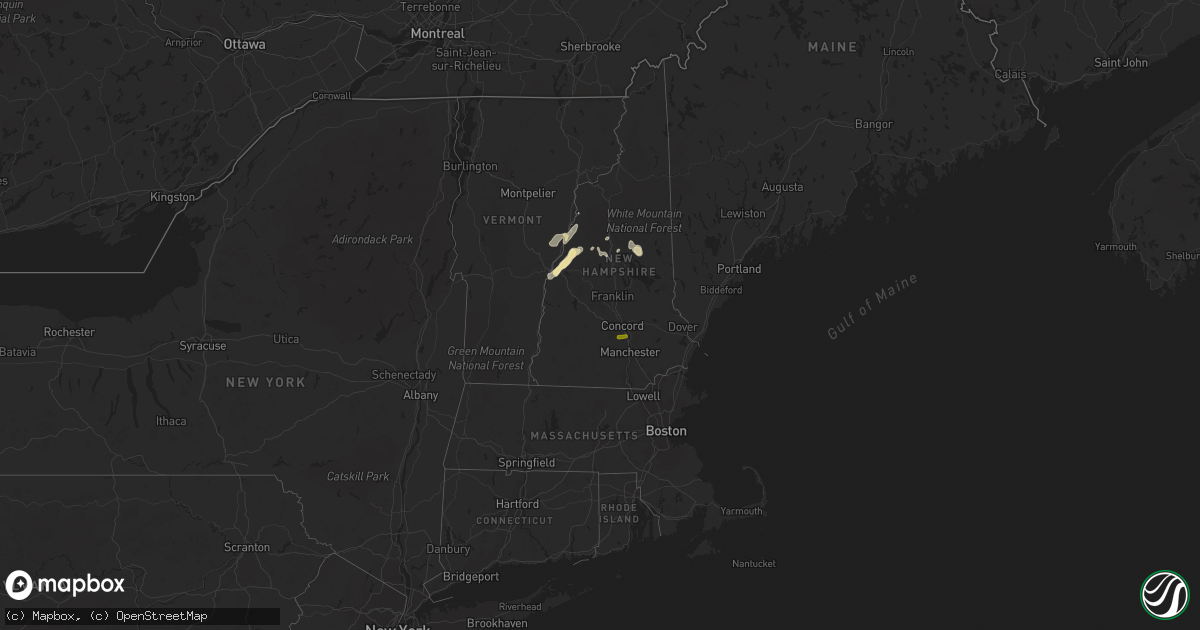
Hail Map in New Hampshire on July 13, 2020
Get this storm
July 13 map
$229
one time, instant access
Download today. No call, no setup
Keep the $229
Bought the map and want the full workflow? Apply the entire $229 to a subscription within 7 days. None of it is wasted.
Every map, not just this one
This buys you this map. Subscription and you get every map we run, in the markets you choose from a few cities to whole states to nationwide. Plus real-time alerts the moment a storm fires.
Contact data
Name, contact info, occupancy, even credit band for addresses in the footprint. You go from where it hit to who to call.
Become the source they trust
Unlimited branding weather history reports on demand. You already have the documented answer ready for the property owner, and you are the one who showed up with it.
Property data and RoofTrace estimates
Pull up any address you have got, its value and the exact code rules for that jurisdiction, straight from One Click Code. Then RoofTrace estimates the squares, pitch, and roof value, priced the way you price.
Storm reports in New Hampshire
New Hampshire
| Date | Description |
|---|---|
| 07/13/20201:44 PM CDT | Report received via social media of 60 mph wind gust measured at port city air. |
| 07/13/202012:00 PM CDT | Trees and wires down. |
| 07/13/202012:00 PM CDT | Trees and power lines down. Reported at 182 colby road weare nh. |
| 07/13/20207:49 AM CDT | At 1249 PM EDT, severe thunderstorms were located along a line extending from near Hooksett to near Weare, moving east at 5 mph. HAZARD...60 mph wind gusts and quarter size hail. SOURCE...Radar indicated. IMPACT...Hail damage to vehicles is expected. Expect wind damage to roofs, siding, and trees. Locations impacted include... Concord, Hooksett, New Boston, Weare, Goffstown, Bow, Allenstown, Dunbarton and Pembroke.This includes Interstate 93 between mile markers 31 and 33. |
| 07/13/20203:30 AM CDT | Lebanon police report numerous trees down in the city. |
| 07/13/20203:01 AM CDT | At 801 PM EDT, a severe thunderstorm was located near Sandwich, or near Moultonborough, moving southeast at 15 mph. HAZARD...60 mph wind gusts and quarter size hail. SOURCE...Radar indicated. IMPACT...Hail damage to vehicles is expected. Expect wind damage to roofs, siding, and trees. Locations impacted include... Moultonborough, Ossipee, Effingham, Sandwich, Tamworth, Wolfeboro, Madison, Freedom and Tuftonboro. |
| 07/12/202011:07 PM CDT | At 407 PM EDT, a severe thunderstorm was located 8 miles east of Berlin, moving east at 20 mph. HAZARD...60 mph wind gusts and quarter size hail. SOURCE...Radar indicated. IMPACT...Hail damage to vehicles is expected. Expect wind damage to roofs, siding, and trees. Locations impacted include... Bethel, Rumford, Andover, Grafton, Greenwood, Hanover, Gilead, Newry, Riley, Mason, Batchelders Grant, Albany, Woodstock, Roxbury and Shelburne.This also includes... Old Speck Mountain, Grafton Notch, Mount Success, Screw AugerFalls, and Gentian Pond. |
| 07/12/20209:44 PM CDT | At 243 PM EDT, a severe thunderstorm was located over Topsfield, or near Danvers, moving northeast at 10 mph. HAZARD...60 mph wind gusts and penny size hail. SOURCE...Radar indicated. IMPACT...Expect damage to trees and power lines. Locations impacted include... Haverhill, Beverly, Andover, North Andover, Danvers, Newburyport, Amesbury, Ipswich, Middleton, Salisbury, Georgetown, Boxford, Hamilton, Newbury, Groveland, Merrimac, Topsfield, Rowley, Wenham and West Newbury. |
All States Impacted by Hail Map on July 13, 2020
Cities Impacted by Hail Map on July 13, 2020
- Deadwood, SD
- Sundance, WY
- Lead, SD
- Purdum, NE
- Brewster, NE
- Saint Francis, KS
- Colby, KS
- Goodland, KS
- Benkelman, NE
- Yuma, CO
- Haxtun, CO
- Holyoke, CO
- Rockingham, NC
- Maple Hill, NC
- Bemidji, MN
- Laporte, MN
- Cass Lake, MN
- Lake George, MN
- Winona, KS
- Burlington, CO
- Edson, KS
- Weskan, KS
- Cando, ND
- Cheyenne, WY
- Sharon Springs, KS
- Cambridge, NE
- Chesterfield, SC
- Saint Johns, AZ
- Galivants Ferry, SC
- Gresham, SC
- Conway, SC
- Aynor, SC
- New Bern, NC
- Fleming, CO
- Otis, CO
- Mcalester, OK
- Wayne, NE
- Bricelyn, MN
- Loris, SC
- Longs, SC
- Sterling, CO
- Burwell, NE
- Amelia, NE
- Chambers, NE
- Hill City, KS
- Stuart, NE
- Indianola, NE
- Culbertson, NE
- McCook, NE
- Parks, NE
- Seven Springs, NC
- Andrews, SC
- Georgetown, SC
- Munich, ND
- Taylor, NE
- Krebs, OK
- Stratton, NE
- Trenton, NE
- Laramie, WY
- Maywood, NE
- Imperial, NE
- New Raymer, CO
- Spalding, NE
- Norfolk, NE
- Myrtle Beach, SC
- Maple, NC
- Barco, NC
- Egeland, ND
- Starkweather, ND
- Tryon, NE
- Sutherland, NE
- North Platte, NE
- Hershey, NE
- Enders, NE
- Vancleave, MS
- Stratton, CO
- Indianola, OK
- Dalhart, TX
- Ericson, NE
- Bluffton, MN
- Wadena, MN
- New York Mills, MN
- Sebeka, MN
- Verndale, MN
- Sinton, TX
- Taft, TX
- Maysville, NC
- Wallace, KS
- Rocklake, ND
- Middlesex, NC
- Wallace, SC
- Society Hill, SC
- Burns, WY
- Wolford, ND
- Rugby, ND
- Eagle Bend, MN
- Idalia, CO
- Polkton, NC
- Wadesboro, NC
- Bethune, CO
- Raleigh, NC
- Willow Spring, NC
- Lexington, NE
- Leoti, KS
- Long Prairie, MN
- Clarissa, MN
- Miltona, MN
- Browerville, MN
- Parkers Prairie, MN
- Atkinson, NE
- Long Pine, NE
- Pollocksville, NC
- Randall, MN
- Maxwell, NE
- Hoxie, KS
- Jacksonville, NC
- Oneill, NE
- Quinn, SD
- Philip, SD
- Wall, SD
- Goldsboro, NC
- La Grange, NC
- Bagley, MN
- Oberlin, KS
- Wellfleet, NE
- Nisswa, MN
- Pillager, MN
- South Tamworth, NH
- Center Sandwich, NH
- North Sandwich, NH
- Moultonborough, NH
- Blackduck, MN
- Bogue, KS
- Arapahoe, CO
- Hayes Center, NE
- Hendley, NE
- Wilsonville, NE
- Norton, KS
- Champion, NE
- Cozad, NE
- Eustis, NE
- Jamestown, SC
- Newbury, VT
- Broadway, NC
- Wallace, NE
- Brookville, KS
- Fuquay Varina, NC
- South Strafford, VT
- Lyme, NH
- Piermont, NH
- Post Mills, VT
- Fairlee, VT
- Thetford Center, VT
- Orford, NH
- West Fairlee, VT
- Bradford, VT
- Oakley, KS
- Wray, CO
- Haigler, NE
- Tribune, KS
- Springfield, CO
- Pierce, NE
- Wauneta, NE
- Etna, NH
- Lebanon, NH
- Hanover, NH
- Enfield, NH
- Little Falls, MN
- Campton, NH
- Holderness, NH
- Baker, FL
- Edenton, NC
- Brewster, KS
- Grant, NE
- Grinnell, KS
- Apex, NC
- Garner, NC
- Atwood, OK
- Holdenville, OK
- New Iberia, LA
- Loreauville, LA
- Box Elder, SD
- New Underwood, SD
- Piedmont, SD
- Sturgis, SD
- Magnolia, NC
- Clearwater, NE
- Ewing, NE
- Wood Lake, NE
- Canaan, NH
- West Lebanon, NH
- Rumney, NH
- Bethune, SC
- Granite Canon, WY
- Tie Siding, WY
- Meadow Grove, NE
- Battle Creek, NE
- Mount Olive, NC
- Florence, SC
- Langdon, ND
- Pierz, MN
- Hillman, MN
- Springview, NE
- Farnam, NE
- Orrum, NC
- Fairmont, NC
- Petersburg, NE
- Tilden, NE
- Morland, KS
- Winside, NE
- Lancaster, MN
- Dunning, NE
- Elwood, NE
- Curtis, NE
- Moorefield, NE
- Brady, NE
- Fosston, MN
- Lengby, MN
- Hackensack, MN
- Danbury, NE
- Jeanerette, LA
- Emerald Isle, NC
- Greeley, NE
- Bassett, NE
- Bird City, KS
- Stockton, KS
- Conway, NC
- Marion, SC
- Levant, KS
- Kanorado, KS
- Wingate, NC
- Monroe, NC
- Frost, MN
- Blue Earth, MN
- Linden, NC
- Bunnlevel, NC
- Staples, MN
- Swansboro, NC
- Ainsworth, NE
- Wells, MN
- Madrid, NE
- Anacoco, LA
- Osnabrock, ND
- Bladenboro, NC
- Naper, NE
- Cove City, NC
- Lebanon, NE
- Mylo, ND
- Wales, ND
- Waves, NC
- Herndon, KS
- Elgin, NE
- Mathis, TX
- Maple, WI
- Stuart, OK
- Alsen, ND
- Aldrich, MN
- Moorcroft, WY
- Tabor City, NC
- Penokee, KS
- Bartley, NE
- Mount Croghan, SC
- Peachland, NC
- Ruby, SC
- Vilas, CO
- Walsh, CO
- Walker, MN
- Saint Martinville, LA
- Bison, KS
- Otis, KS
- Longville, MN
- Marston, NC
- Laurel Hill, NC
- Smithfield, NC
- Campo, CO
- Elmore, MN
- Neligh, NE
- Grainfield, KS
- Colfax, WI
- Chippewa Falls, WI
- North Haverhill, NH
- Plymouth, NH
- Dustin, OK
- Lamar, OK
- Swanville, MN
- Cushing, MN
- Pittsburg, OK
- Cut Off, LA
- Ogallala, NE
- Lenora, KS
- Great Bend, KS
- Albert, KS
- McDonald, KS
- Sneads Ferry, NC
- Holly Ridge, NC
- Black Hawk, SD
- Nemo, SD
- Valentine, NE
- Leeds, ND
- Elm Creek, NE
- Woodland, NC
- Murfreesboro, NC
- Thornton, NH
- Sanford, NC
- Hoskins, NE
- Nichols, SC
- Bennettsville, SC
- Snowflake, AZ
- Hobucken, NC
- Dover, NC
- Cedar Island, NC
- Thibodaux, LA
- Currituck, NC
- Fairmont, MN
- Swea City, IA
- Armstrong, IA
- Granada, MN
- Elizabethtown, NC
- Park Rapids, MN
- Plainview, NE
- Brunswick, NE
- Royalton, MN
- Park, KS
- Spencer, NE
- Stockville, NE
- Trenton, NC
- Gilman, WI
- Clayton, NC
- Shawboro, NC
- Wewoka, OK
- White River Junction, VT
- Plainfield, NH
- North Hartland, VT
- Mobile, AL
- Johnstown, NE
- Winner, SD
- Elsie, NE
- Ernul, NC
- Bloomer, WI
- Ellsworth, KS
- Paxton, NE
- La Crosse, KS
- Mission, SD
- Vandemere, NC
- Arapahoe, NE
- Upton, WY
- McDavid, FL
- Perham, MN
- Ottertail, MN
- Overton, NE
- Fayetteville, NC
- Corrales, NM
- Bernalillo, NM
- Albuquerque, NM
- Algodones, NM
- Rio Rancho, NM
- Laguna, NM
- Cubero, NM
- Casa Blanca, NM
- Gem, KS
- Nunn, CO
- Briggsdale, CO
- Weldona, CO
- Orchard, CO
- Carpenter, WY
- Fe Warren Afb, WY
- Carr, CO
- Buford, WY
- Grover, CO
- Ault, CO
- Jelm, WY
- Hereford, CO
- Centennial, WY
- Wellington, CO
- Vona, CO
- Dunbarton, NH
- Bow, NH


