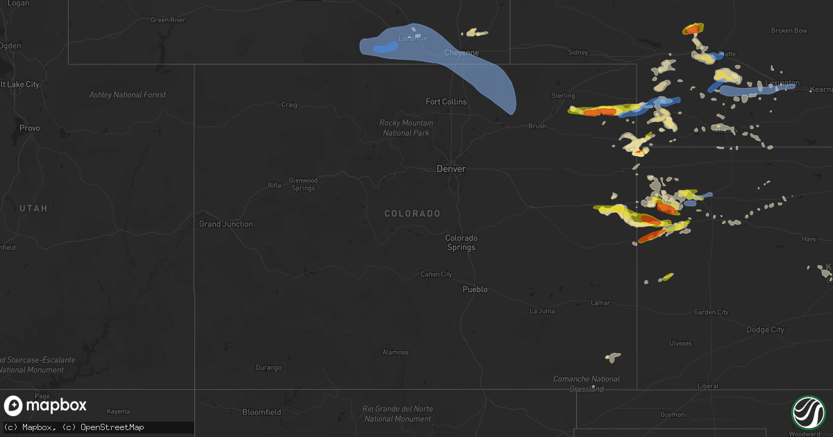
Hail Map in Colorado on July 13, 2020
Get this storm
July 13 map
$229
one time, instant access
Download today. No call, no setup
Keep the $229
Bought the map and want the full workflow? Apply the entire $229 to a subscription within 7 days. None of it is wasted.
Every map, not just this one
This buys you this map. Subscription and you get every map we run, in the markets you choose from a few cities to whole states to nationwide. Plus real-time alerts the moment a storm fires.
Contact data
Name, contact info, occupancy, even credit band for addresses in the footprint. You go from where it hit to who to call.
Become the source they trust
Unlimited branding weather history reports on demand. You already have the documented answer ready for the property owner, and you are the one who showed up with it.
Property data and RoofTrace estimates
Pull up any address you have got, its value and the exact code rules for that jurisdiction, straight from One Click Code. Then RoofTrace estimates the squares, pitch, and roof value, priced the way you price.
Storm reports in Colorado
Colorado
| Date | Description |
|---|---|
| 07/13/20206:30 PM CDT | Relayed from emergency management. |
| 07/13/20206:25 PM CDT | Time estimated by radar. |
| 07/13/20206:07 PM CDT | A local report indicates 74 MPH wind near 2 NW BRIGGSDALE |
| 07/13/20206:03 PM CDT | Mesonet station cw5040 briggsdale. |
| 07/13/20205:55 PM CDT | Spotter network reported damage to buildings. Metal shed... Twisted. Time estimated. |
| 07/13/20205:50 PM CDT | Trained spotter reported power poles down. Time estimated. |
| 07/13/20205:46 PM CDT | Mesonet station cw2715 ault. |
| 07/13/20205:41 PM CDT | A local report indicates 77 MPH wind near 7 NE PURCELL |
| 07/13/20205:35 PM CDT | Mesonet station beyc2 buckeye. |
| 07/13/20205:20 PM CDT | Asos station keeo meeker airport. |
| 07/13/20205:10 PM CDT | Mesonet station co166 cr-82 buckeye rd. |
| 07/13/20205:00 PM CDT | A local report indicates 60 MPH wind near 3 W KIM |
| 07/13/20204:00 PM CDT | Mesonet station gspc2 gunsight. Time is estimated. |
| 07/13/20203:57 PM CDT | A local report indicates 63 MPH wind near 1 NNE WALDEN |
| 07/13/20203:43 PM CDT | Awos station k1ow oscar madis. |
| 07/13/20203:33 PM CDT | Mesonet station cw5040 briggsdale. |
| 07/13/20203:46 AM CDT | At 846 PM MDT/946 PM CDT/, severe thunderstorms were located along a line extending from 5 miles south of McDonald to 11 miles north of Goodland to 5 miles north of Kanorado, moving east at 35 mph. HAZARD...60 mph wind gusts and quarter size hail. SOURCE...Radar indicated. IMPACT...Hail damage to vehicles is expected. Expect wind damage to roofs, siding, and trees. Locations impacted include... Colby, Goodland, Oakley, Brewster, Kanorado, Ruleton and Levant. This includes Interstate 70 in Kansas between mile markers 0 and 75. |
| 07/13/20203:33 AM CDT | At 833 PM MDT/933 PM CDT/, severe thunderstorms were located along a line extending from 10 miles north of Wallace to 9 miles southwest of Weskan, moving east at 30 mph. HAZARD...70 mph wind gusts and half dollar size hail. SOURCE...Radar indicated. IMPACT...Hail damage to vehicles is expected. Expect considerable tree damage. Wind damage is also likely to mobile homes, roofs, and outbuildings. Locations impacted include... Oakley, Sharon Springs, Weskan, Winona, Monument, Wallace and Russell Springs. |
| 07/13/20201:37 AM CDT | At 637 PM MDT, a severe thunderstorm was located 9 miles southeast of Burlington, moving southeast at 30 mph. HAZARD...Golf ball size hail and 70 mph wind gusts. SOURCE...Radar indicated. IMPACT...People and animals outdoors will be injured. Expect hail damage to roofs, siding, windows, and vehicles. Expect considerable tree damage. Wind damage is also likely to mobile homes, roofs, and outbuildings. Locations impacted include... Sharon Springs and Weskan. This includes the following highways... Interstate 70 in Colorado between mile markers 439 and 446. Highway 385 between mile markers 166 and 183. |
| 07/13/202012:59 AM CDT | At 558 PM MDT, severe thunderstorms were located along a line extending from 9 miles northeast of Westplains to near Twelve-Mile Corner, or along a line extending from 22 miles southeast of Kimball to 13 miles south of Fort Morgan, moving east at 35 mph. HAZARD...60 mph wind gusts. SOURCE...Radar indicated. IMPACT...Expect damage to roofs, siding, and trees. Locations impacted include... Sterling, Akron, Brush, Fleming, Merino, Iliff, Hillrose, Peetz, Crook, Prewitt Reservoir, Padroni, Atwood, Twelve-Mile Corner, Burdett, Snyder, Midway, Woodrow, Gary, Proctor and Elba. |
| 07/13/202012:39 AM CDT | At 539 PM CDT, severe thunderstorms were located along a line extending from 9 miles northeast of Kenton to 7 miles west of Felt to 8 miles northeast of Sedan, moving east at 20 mph. HAZARD...60 mph wind gusts. SOURCE...Radar indicated. IMPACT...Minor damage to roofs, siding, and trees is possible. Locations impacted include... Boise City, Texline, Keyes, Kenton, Wheeless, Black Mesa Park, Ware and Felt. |
| 07/13/202012:38 AM CDT | At 538 PM MDT, severe thunderstorms were located along a line extending from 5 miles south of New Raymer to 3 miles west of Hoyt, or along a line extending from 18 miles north of Fort Morgan to 42 miles southeast of Greeley, moving east at 50 mph. HAZARD...60 mph wind gusts. SOURCE...Radar indicated. IMPACT...Expect damage to roofs, siding, and trees. Locations impacted include... Fort Morgan, Brush, Wiggins, Log Lane Village, Hoyt, Antelope Springs, Weldona, Adena, Twelve-Mile Corner, Snyder and Adena School. |
| 07/13/202012:30 AM CDT | At 529 PM MDT, a severe thunderstorm was located near Vilas, or near Springfield, moving northeast at 30 mph. HAZARD...60 mph wind gusts and nickel size hail. SOURCE...Radar indicated. IMPACT...Expect damage to roofs, siding, and trees. Locations impacted include... Walsh, Vilas and Stonington. |
| 07/13/202012:29 AM CDT | At 529 PM MDT, severe thunderstorms were located along a line extending from 14 miles north of Stratton to 3 miles northeast of Seibert, moving southeast at 25 mph. HAZARD...60 mph wind gusts and quarter size hail. SOURCE...Radar indicated. IMPACT...Hail damage to vehicles is expected. Expect wind damage to roofs, siding, and trees. Locations impacted include... Burlington, Stratton, Seibert, Bonny Reservoir, Bethune, Vona and Hale.This includes the following highways... Interstate 70 in Colorado between mile markers 402 and 450. Highway 385 between mile markers 170 and 217. |
| 07/13/202012:00 AM CDT | At 459 PM MDT, severe thunderstorms were located along a line extending from Panorama Point to 4 miles west of Briggsdale, or along a line extending from 24 miles southwest of Kimball to 22 miles northeast of Greeley, moving east at 45 mph. These are very dangerous storms. HAZARD...80 mph wind gusts. SOURCE...Radar indicated. IMPACT...Flying debris will be dangerous to those caught without shelter. Mobile homes will be heavily damaged. Expect considerable damage to roofs, windows, and vehicles. Extensive tree damage and power outages are likely. Locations impacted include... New Raymer, Keota, Stoneham, Westplains, Briggsdale, Pawnee Pass, Pawnee Buttes and Willard. |
| 07/12/202011:44 PM CDT | At 444 PM MDT, severe thunderstorms were located along a line extending from near Meriden Rest Area to 10 miles east of Rockport, moving east at 45 mph. HAZARD...60 mph wind gusts and penny size hail. SOURCE...Radar indicated. IMPACT...Expect damage to roofs, siding, and trees. These severe thunderstorms will remain over mainly rural areas of western Kimball, southwestern Banner and eastern Laramie Counties.This includes the following highways... Interstate 80 in Wyoming between mile markers 376 and 402. Interstate 80 in Nebraska between mile markers 1 and 5. |
| 07/12/202011:29 PM CDT | At 429 PM MDT, a severe thunderstorm was located 7 miles southeast of Sterling, moving east at 30 mph. HAZARD...60 mph wind gusts. SOURCE...Radar indicated. IMPACT...Expect damage to roofs, siding, and trees. Locations impacted include... Sterling, Fleming, Merino, Prewitt Reservoir, St Petersburg, Atwood, Burdett and Lone Star. |
| 07/12/202011:05 PM CDT | At 403 PM MDT, severe thunderstorms were located along a line extending from near Iron Mountain to 6 miles north of Livermore, moving east at 55 mph. HAZARD...70 mph wind gusts and penny size hail. SOURCE...Radar indicated. IMPACT...Expect considerable tree damage. Damage is likely to mobile homes, roofs, and outbuildings. Locations impacted include... Cheyenne, South Greeley, Hillsdale, Federal, Crystal Lake Reservoir, Crystal Lake Campground, Ranchettes, Warren AFB, Frontier Park, North Cheyenne, Whitaker, Horse Creek, Warren Af Base, Fox Farm-College and South Greeley High.This includes the following highways... Interstate 25 in Wyoming between mile markers 1 and 45. Interstate 80 in Wyoming between mile markers 340 and 384. |
| 07/12/202010:16 PM CDT | At 316 PM MDT, severe thunderstorms were located along a line extending from near Rock River to 8 miles northeast of North Fork Campground to near Lake Owen, moving east at 45 mph. HAZARD...60 mph wind gusts. SOURCE...Radar indicated. IMPACT...Expect damage to roofs, siding, and trees. Locations impacted include... Laramie, Albany, Bosler, Libby Creek Campground, Woods Landing-Jelm, Illinois Creek Campground, Miller Lake Campground, Rob Roy Campground, Centennial, Nash Fork Campground, Evans Creek Campground, Lake Owen Campground, Boswell Creek Campground, Lake Hattie Reservoir, Woods Landing, Rob Roy Reservoir, Lake Owen, North Fork Campground, Bobbie Thompson Campground and Hutton Lake.This includes Interstate 80 in Wyoming between mile markers 280 and309. |
| 07/12/202010:13 PM CDT | At 313 PM MDT, severe thunderstorms were located along a line extending from 9 miles northwest of Westplains to 5 miles south of New Raymer, or along a line extending from 17 miles south of Kimball to 19 miles north of Fort Morgan, moving east at 30 mph. HAZARD...60 mph wind gusts. SOURCE...Radar indicated. IMPACT...Expect damage to roofs, siding, and trees. Locations impacted include... Sterling, Iliff, Peetz, New Raymer, Padroni, Atwood, North Sterling Reservoir, Willard, Stoneham, Westplains, Logan Corners, Pawnee Pass and Pawnee Buttes. |
| 07/12/20209:20 PM CDT | Public reported 60mph wind gust via facebook. |
| 07/12/20209:00 PM CDT | Public report of quarter size hail estimated at 8pm mdt. |
| 07/12/20208:39 PM CDT | Corrects previous tstm wnd dmg report from wray. |
| 07/12/20207:33 PM CDT | Asos station kako akron. |
| 07/12/20207:08 PM CDT | Time estimated from radar. |
| 07/12/20207:07 PM CDT | Mesonet station tt567 crow creek. |
All States Impacted by Hail Map on July 13, 2020
Cities Impacted by Hail Map on July 13, 2020
- Deadwood, SD
- Sundance, WY
- Lead, SD
- Purdum, NE
- Brewster, NE
- Saint Francis, KS
- Colby, KS
- Goodland, KS
- Benkelman, NE
- Yuma, CO
- Haxtun, CO
- Holyoke, CO
- Rockingham, NC
- Maple Hill, NC
- Bemidji, MN
- Laporte, MN
- Cass Lake, MN
- Lake George, MN
- Winona, KS
- Burlington, CO
- Edson, KS
- Weskan, KS
- Cando, ND
- Cheyenne, WY
- Sharon Springs, KS
- Cambridge, NE
- Chesterfield, SC
- Saint Johns, AZ
- Galivants Ferry, SC
- Gresham, SC
- Conway, SC
- Aynor, SC
- New Bern, NC
- Fleming, CO
- Otis, CO
- Mcalester, OK
- Wayne, NE
- Bricelyn, MN
- Loris, SC
- Longs, SC
- Sterling, CO
- Burwell, NE
- Amelia, NE
- Chambers, NE
- Hill City, KS
- Stuart, NE
- Indianola, NE
- Culbertson, NE
- McCook, NE
- Parks, NE
- Seven Springs, NC
- Andrews, SC
- Georgetown, SC
- Munich, ND
- Taylor, NE
- Krebs, OK
- Stratton, NE
- Trenton, NE
- Laramie, WY
- Maywood, NE
- Imperial, NE
- New Raymer, CO
- Spalding, NE
- Norfolk, NE
- Myrtle Beach, SC
- Maple, NC
- Barco, NC
- Egeland, ND
- Starkweather, ND
- Tryon, NE
- Sutherland, NE
- North Platte, NE
- Hershey, NE
- Enders, NE
- Vancleave, MS
- Stratton, CO
- Indianola, OK
- Dalhart, TX
- Ericson, NE
- Bluffton, MN
- Wadena, MN
- New York Mills, MN
- Sebeka, MN
- Verndale, MN
- Sinton, TX
- Taft, TX
- Maysville, NC
- Wallace, KS
- Rocklake, ND
- Middlesex, NC
- Wallace, SC
- Society Hill, SC
- Burns, WY
- Wolford, ND
- Rugby, ND
- Eagle Bend, MN
- Idalia, CO
- Polkton, NC
- Wadesboro, NC
- Bethune, CO
- Raleigh, NC
- Willow Spring, NC
- Lexington, NE
- Leoti, KS
- Long Prairie, MN
- Clarissa, MN
- Miltona, MN
- Browerville, MN
- Parkers Prairie, MN
- Atkinson, NE
- Long Pine, NE
- Pollocksville, NC
- Randall, MN
- Maxwell, NE
- Hoxie, KS
- Jacksonville, NC
- Oneill, NE
- Quinn, SD
- Philip, SD
- Wall, SD
- Goldsboro, NC
- La Grange, NC
- Bagley, MN
- Oberlin, KS
- Wellfleet, NE
- Nisswa, MN
- Pillager, MN
- South Tamworth, NH
- Center Sandwich, NH
- North Sandwich, NH
- Moultonborough, NH
- Blackduck, MN
- Bogue, KS
- Arapahoe, CO
- Hayes Center, NE
- Hendley, NE
- Wilsonville, NE
- Norton, KS
- Champion, NE
- Cozad, NE
- Eustis, NE
- Jamestown, SC
- Newbury, VT
- Broadway, NC
- Wallace, NE
- Brookville, KS
- Fuquay Varina, NC
- South Strafford, VT
- Lyme, NH
- Piermont, NH
- Post Mills, VT
- Fairlee, VT
- Thetford Center, VT
- Orford, NH
- West Fairlee, VT
- Bradford, VT
- Oakley, KS
- Wray, CO
- Haigler, NE
- Tribune, KS
- Springfield, CO
- Pierce, NE
- Wauneta, NE
- Etna, NH
- Lebanon, NH
- Hanover, NH
- Enfield, NH
- Little Falls, MN
- Campton, NH
- Holderness, NH
- Baker, FL
- Edenton, NC
- Brewster, KS
- Grant, NE
- Grinnell, KS
- Apex, NC
- Garner, NC
- Atwood, OK
- Holdenville, OK
- New Iberia, LA
- Loreauville, LA
- Box Elder, SD
- New Underwood, SD
- Piedmont, SD
- Sturgis, SD
- Magnolia, NC
- Clearwater, NE
- Ewing, NE
- Wood Lake, NE
- Canaan, NH
- West Lebanon, NH
- Rumney, NH
- Bethune, SC
- Granite Canon, WY
- Tie Siding, WY
- Meadow Grove, NE
- Battle Creek, NE
- Mount Olive, NC
- Florence, SC
- Langdon, ND
- Pierz, MN
- Hillman, MN
- Springview, NE
- Farnam, NE
- Orrum, NC
- Fairmont, NC
- Petersburg, NE
- Tilden, NE
- Morland, KS
- Winside, NE
- Lancaster, MN
- Dunning, NE
- Elwood, NE
- Curtis, NE
- Moorefield, NE
- Brady, NE
- Fosston, MN
- Lengby, MN
- Hackensack, MN
- Danbury, NE
- Jeanerette, LA
- Emerald Isle, NC
- Greeley, NE
- Bassett, NE
- Bird City, KS
- Stockton, KS
- Conway, NC
- Marion, SC
- Levant, KS
- Kanorado, KS
- Wingate, NC
- Monroe, NC
- Frost, MN
- Blue Earth, MN
- Linden, NC
- Bunnlevel, NC
- Staples, MN
- Swansboro, NC
- Ainsworth, NE
- Wells, MN
- Madrid, NE
- Anacoco, LA
- Osnabrock, ND
- Bladenboro, NC
- Naper, NE
- Cove City, NC
- Lebanon, NE
- Mylo, ND
- Wales, ND
- Waves, NC
- Herndon, KS
- Elgin, NE
- Mathis, TX
- Maple, WI
- Stuart, OK
- Alsen, ND
- Aldrich, MN
- Moorcroft, WY
- Tabor City, NC
- Penokee, KS
- Bartley, NE
- Mount Croghan, SC
- Peachland, NC
- Ruby, SC
- Vilas, CO
- Walsh, CO
- Walker, MN
- Saint Martinville, LA
- Bison, KS
- Otis, KS
- Longville, MN
- Marston, NC
- Laurel Hill, NC
- Smithfield, NC
- Campo, CO
- Elmore, MN
- Neligh, NE
- Grainfield, KS
- Colfax, WI
- Chippewa Falls, WI
- North Haverhill, NH
- Plymouth, NH
- Dustin, OK
- Lamar, OK
- Swanville, MN
- Cushing, MN
- Pittsburg, OK
- Cut Off, LA
- Ogallala, NE
- Lenora, KS
- Great Bend, KS
- Albert, KS
- McDonald, KS
- Sneads Ferry, NC
- Holly Ridge, NC
- Black Hawk, SD
- Nemo, SD
- Valentine, NE
- Leeds, ND
- Elm Creek, NE
- Woodland, NC
- Murfreesboro, NC
- Thornton, NH
- Sanford, NC
- Hoskins, NE
- Nichols, SC
- Bennettsville, SC
- Snowflake, AZ
- Hobucken, NC
- Dover, NC
- Cedar Island, NC
- Thibodaux, LA
- Currituck, NC
- Fairmont, MN
- Swea City, IA
- Armstrong, IA
- Granada, MN
- Elizabethtown, NC
- Park Rapids, MN
- Plainview, NE
- Brunswick, NE
- Royalton, MN
- Park, KS
- Spencer, NE
- Stockville, NE
- Trenton, NC
- Gilman, WI
- Clayton, NC
- Shawboro, NC
- Wewoka, OK
- White River Junction, VT
- Plainfield, NH
- North Hartland, VT
- Mobile, AL
- Johnstown, NE
- Winner, SD
- Elsie, NE
- Ernul, NC
- Bloomer, WI
- Ellsworth, KS
- Paxton, NE
- La Crosse, KS
- Mission, SD
- Vandemere, NC
- Arapahoe, NE
- Upton, WY
- McDavid, FL
- Perham, MN
- Ottertail, MN
- Overton, NE
- Fayetteville, NC
- Corrales, NM
- Bernalillo, NM
- Albuquerque, NM
- Algodones, NM
- Rio Rancho, NM
- Laguna, NM
- Cubero, NM
- Casa Blanca, NM
- Gem, KS
- Nunn, CO
- Briggsdale, CO
- Weldona, CO
- Orchard, CO
- Carpenter, WY
- Fe Warren Afb, WY
- Carr, CO
- Buford, WY
- Grover, CO
- Ault, CO
- Jelm, WY
- Hereford, CO
- Centennial, WY
- Wellington, CO
- Vona, CO
- Dunbarton, NH
- Bow, NH


