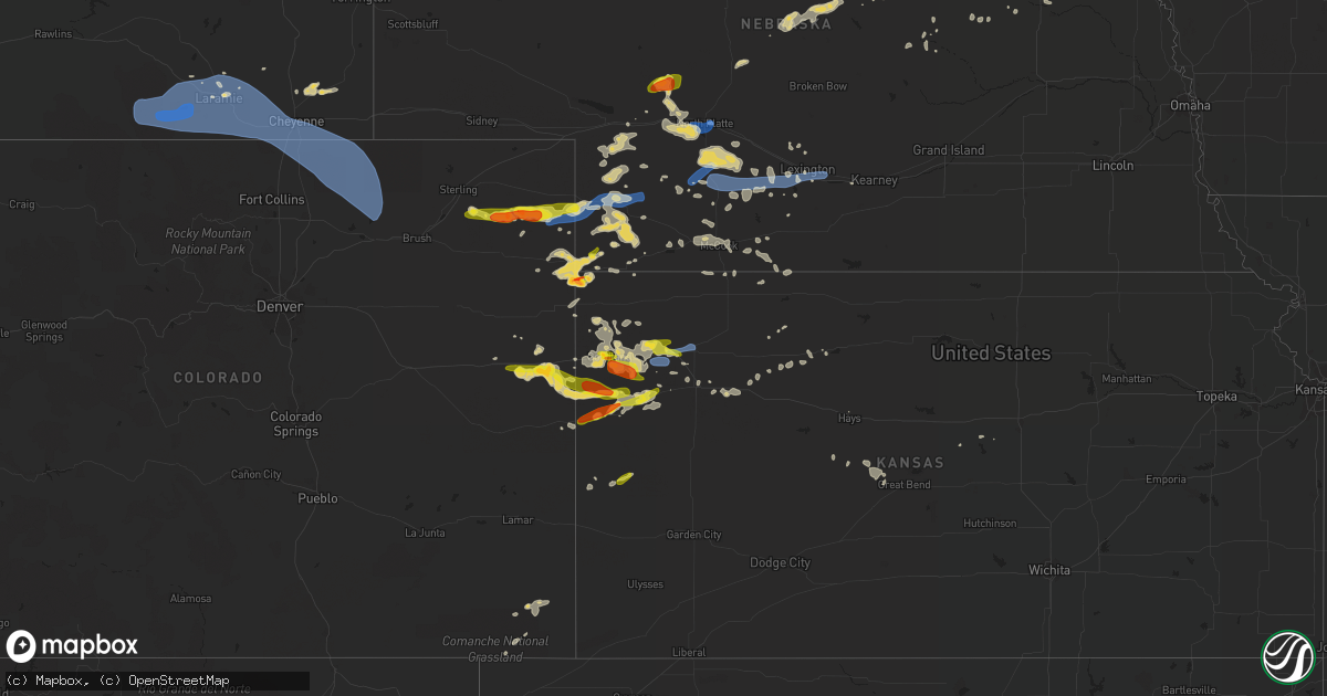
Hail Map on July 13, 2020
Get this storm
July 13 map
$229
one time, instant access
Download today. No call, no setup
Keep the $229
Bought the map and want the full workflow? Apply the entire $229 to a subscription within 7 days. None of it is wasted.
Every map, not just this one
This buys you this map. Subscription and you get every map we run, in the markets you choose from a few cities to whole states to nationwide. Plus real-time alerts the moment a storm fires.
Contact data
Name, contact info, occupancy, even credit band for addresses in the footprint. You go from where it hit to who to call.
Become the source they trust
Unlimited branding weather history reports on demand. You already have the documented answer ready for the property owner, and you are the one who showed up with it.
Property data and RoofTrace estimates
Pull up any address you have got, its value and the exact code rules for that jurisdiction, straight from One Click Code. Then RoofTrace estimates the squares, pitch, and roof value, priced the way you price.
States Impacted by Hail Map on July 13, 2020
Storm reports
Nebraska
| Date | Description |
|---|---|
| 07/13/20206:45 PM CDT | A local report indicates 1.00 inch wind near 12 ESE BUCKTAIL LAKE |
| 07/13/20206:57 AM CDT | At 1157 PM CDT, a severe thunderstorm was located near Woodruff, or 22 miles north of Phillipsburg, moving east at 55 mph. HAZARD...60 mph wind gusts. SOURCE...Radar indicated. IMPACT...Expect damage to roofs, siding, and trees. Locations impacted include... Alma, Oxford, Orleans, Stamford, Republican City, Long Island, Huntley, Ragan, Harlan County Dam and Woodruff. |
| 07/13/20206:31 AM CDT | At 1131 PM CDT, severe thunderstorms were located along a line extending from Holbrook to Hendley to 9 miles south of Wilsonville, moving east at 45 mph. HAZARD...60 mph wind gusts. SOURCE...Radar indicated. IMPACT...Expect damage to roofs, siding, and trees. Locations impacted include... Alma, Oxford, Beaver City, Orleans, Stamford, Republican City, Long Island, Prairie View, Edison, Huntley, Ragan, Hollinger, Woodruff and Harlan County Dam. |
| 07/13/20206:07 AM CDT | At 1107 PM CDT, severe thunderstorms were located along a line extending from near Wilsonville to 7 miles west of Norcatur, moving east at 40 mph. HAZARD...70 mph wind gusts and quarter size hail. SOURCE...Radar indicated. IMPACT...Hail damage to vehicles is expected. Expect considerable tree damage. Wind damage is also likely to mobile homes, roofs, and outbuildings. Locations impacted include... Norton, Oberlin, Almena, Lenora, Norcatur, Jennings and Lebanon. |
| 07/13/20205:14 AM CDT | At 1011 PM CDT, severe thunderstorms were located along a line extending from 4 miles northwest of McCook to 3 miles southwest of Herndon to 12 miles southeast of McDonald, moving east at 55 mph. HAZARD...60 mph wind gusts and quarter size hail. SOURCE...Trained weather spotters. At 948 pm CDT, a 62 mph wind gust was reported in Trenton, Nebraska. A 65 mph wind gusts was also reported in Ludell, Kansas at 1004 pm CDT. IMPACT...Hail damage to vehicles is expected. Expect wind damage to roofs, siding, and trees. Locations impacted include... McCook, Oberlin, Indianola, Bartley, Norcatur, Danbury and Jennings. |
| 07/13/20204:56 AM CDT | At 955 PM CDT, severe thunderstorms were located along a line extending from near Oconto to near Lexington to near Elwood to 11 miles north of Arapahoe, moving east at 50 mph. HAZARD...60 mph wind gusts and penny size hail. SOURCE...Radar indicated. IMPACT...Expect damage to roofs, siding, and trees. Locations impacted include... Kearney, Lexington, Holdrege, Cozad, Elm Creek, Bertrand, Axtell, Elwood, Overton, Odessa, Loomis, Amherst, Sumner, Funk, Riverdale, Miller, Eddyville, Smithfield and Johnson Lake.This includes Interstate 80 between mile markers 223 and 273. |
| 07/13/20204:45 AM CDT | At 945 PM CDT, severe thunderstorms were located along a line extending from near Eustis to 9 miles southwest of Stockville, moving east at 40 mph. HAZARD...60 mph wind gusts and nickel size hail. SOURCE...Radar indicated. IMPACT...Expect damage to roofs, siding, and trees. Locations impacted include... Eustis, Moorefield, Stockville, Medicine Creek Reservoir State Recreation Area, Orafino, Freedom and Dancing Leaf Earth Lodge. |
| 07/13/20204:34 AM CDT | At 933 PM CDT, severe thunderstorms were located along a line extending from 9 miles southeast of Wauneta to 10 miles north of McDonald to 8 miles southeast of St. Francis, moving east at 45 mph. HAZARD...60 mph wind gusts and quarter size hail. SOURCE...Law enforcement. At 921 pm CDT, a 58 mph wind gust was reported in Benkelman. IMPACT...Hail damage to vehicles is expected. Expect wind damage to roofs, siding, and trees. Locations impacted include... Atwood, Trenton, Culbertson, Palisade, Stratton, McDonald and Herndon. |
| 07/13/20204:13 AM CDT | At 912 PM CDT, severe thunderstorms were located along a line extending from 11 miles northeast of Maxwell to 7 miles northeast of Moorefield to 10 miles north of McCook, moving east at 35 mph. These are very dangerous storms. HAZARD...80 mph wind gusts and quarter size hail. SOURCE...Radar indicated. IMPACT...Flying debris will be dangerous to those caught without shelter. Mobile homes will be heavily damaged. Expect considerable damage to roofs, windows, and vehicles. Extensive tree damage and power outages are likely. Locations impacted include... Lexington, Cozad, Gothenburg, Elwood, Smithfield, Willow Island, Johnson Lake and Farnam.This includes Interstate 80 between mile markers 209 and 242. |
| 07/13/20204:05 AM CDT | At 905 PM CDT, severe thunderstorms were located along a line extending from near Brady to 7 miles north of Moorefield to 7 miles west of Stockville, moving east at 35 mph. HAZARD...70 mph wind gusts and nickel size hail. SOURCE...Radar indicated. IMPACT...Expect considerable tree damage. Damage is likely to mobile homes, roofs, and outbuildings. Locations impacted include... Curtis, Brady, Eustis, Maxwell, Moorefield, Stockville, Medicine Creek Reservoir State Recreation Area, Jeffrey Canyon State Wildlife Management Area, Orafino, Freedom and Dancing Leaf Earth Lodge.This includes the following highways... Interstate 80 in Nebraska between mile markers 191 and 207. Highway 83 between mile markers 28 and 29. |
| 07/13/20204:00 AM CDT | At 859 PM CDT, a severe thunderstorm was located near North Platte Airport, or 7 miles east of North Platte, moving east at 25 mph. HAZARD...70 mph wind gusts and penny size hail. SOURCE...Radar indicated. IMPACT...Expect considerable tree damage. Damage is likely to mobile homes, roofs, and outbuildings. Locations impacted include... North Platte, Maxwell, North Platte Airport, Keith and Etna. This includes the following highways... Highway 97 near mile marker 1. Interstate 80 in Nebraska between mile markers 178 and 192. Highway 83 between mile markers 85 and 94. |
| 07/13/20203:26 AM CDT | At 826 PM CDT, severe thunderstorms were located along a line extending from near Wallace to 12 miles south of Dickens to Hayes Center, moving east at 35 mph. HAZARD...70 mph wind gusts and nickel size hail. SOURCE...Radar indicated. IMPACT...Expect considerable tree damage. Damage is likely to mobile homes, roofs, and outbuildings. Locations impacted include... Curtis, Hayes Center, Brady, Wellfleet, Moorefield, Stockville, Lake Maloney State Recreation Area, Maywood, Hamlet, Quick, Cottonwood Canyon State Wildlife Management Area, Hansen Memorial Reserve State Wildlife Management Area, Jeffrey Canyon State Wildlife Management Area, Willow View Campground, Freedom, Hayes Center State Wildlife Management Area, Marengo, Bluegill Haven Campground, Red Willow Reservoir State Recreation Area and Somerset.This includes the following highways... Interstate 80 in Nebraska between mile markers 193 and 202. Highway 83 between mile markers 27 and 76. |
| 07/13/20203:17 AM CDT | At 817 PM CDT, a severe thunderstorm was located near Hershey, or 8 miles west of North Platte, moving east at 25 mph. HAZARD...60 mph wind gusts and quarter size hail. SOURCE...Radar indicated. IMPACT...Hail damage to vehicles is expected. Expect wind damage to roofs, siding, and trees. Locations impacted include... North Platte, Sutherland, Hershey, Maxwell, Sutherland Reservoir State Recreation Area, Lake Maloney State Recreation Area, North Platte Airport, Keith, Coker, O'Fallons and Birdwood.This includes the following highways... Highway 97 between mile markers 1 and 5. Interstate 80 in Nebraska between mile markers 156 and 194. Highway 83 between mile markers 77 and 94. |
| 07/13/20202:58 AM CDT | At 757 PM CDT/657 PM MDT/, severe thunderstorms were located along a line extending from near Sutherland Reservoir State Recreation Area to 10 miles south of Champion, moving east at 30 mph. HAZARD...60 mph wind gusts and half dollar size hail. SOURCE...Radar indicated. IMPACT...Hail damage to vehicles is expected. Expect wind damage to roofs, siding, and trees. Locations impacted include... Imperial, Hayes Center, Wauneta, Wallace, Elsie, Dickens, Enders, Enders Reservoir State Recreation Area, Champion, Hamlet, Grainton, and Somerset.This includes the following highways... Highway 61 between mile markers 25 and 45. Highway 83 between mile markers 61 and 75. |
| 07/13/20202:16 AM CDT | At 716 PM CDT, severe thunderstorms were located along a line extending from 6 miles southeast of Tryon to 11 miles north of Hershey to near Sutherland, moving southeast at 30 mph. HAZARD...Golf ball size hail and 70 mph wind gusts. SOURCE...Radar indicated. IMPACT...People and animals outdoors will be injured. Expect hail damage to roofs, siding, windows, and vehicles. Expect considerable tree damage. Wind damage is also likely to mobile homes, roofs, and outbuildings. Locations impacted include... North Platte, Tryon, Sutherland, Hershey, Maxwell, Ringgold, Sutherland Reservoir State Recreation Area, Lake Maloney State Recreation Area, North Platte Airport, Keith, Coker, O'Fallons and Birdwood.This includes the following highways... Highway 92 between mile markers 203 and 222, and between milemarkers 233 and 234. Highway 97 between mile markers 1 and 33. Interstate 80 in Nebraska between mile markers 151 and 190. Highway 83 between mile markers 72 and 108. |
| 07/13/20202:13 AM CDT | At 713 PM CDT/613 PM MDT/, severe thunderstorms were located along a line extending from 7 miles south of Grant to 16 miles south of Lamar, moving east at 40 mph. HAZARD...Golf ball size hail and 70 mph wind gusts. SOURCE...Radar indicated. IMPACT...People and animals outdoors will be injured. Expect hail damage to roofs, siding, windows, and vehicles. Expect considerable tree damage. Wind damage is also likely to mobile homes, roofs, and outbuildings. Locations impacted include... Imperial, Wauneta, Lamar, Enders, Enders Reservoir State Recreation Area, Champion, Crete, Chase, Center Dam Campground, Wanamaker State Wildfire Management Area, Area A Campground and Church Grove Campground.This includes Highway 61 between mile markers 25 and 58. |
| 07/13/20201:40 AM CDT | At 639 PM CDT/539 PM MDT/, a severe thunderstorm was located 16 miles southwest of Tryon, moving east at 30 mph. HAZARD...Golf ball size hail and 60 mph wind gusts. SOURCE...Radar indicated. IMPACT...People and animals outdoors will be injured. Expect hail damage to roofs, siding, windows, and vehicles. Expect wind damage to roofs, siding, and trees. Locations impacted include... Tryon.This includes the following highways... Highway 92 between mile markers 190 and 209. Highway 97 between mile markers 14 and 40. |
| 07/13/20201:11 AM CDT | At 611 PM MDT, a severe thunderstorm was located 6 miles southwest of Pleasant Valley, or 8 miles southeast of Holyoke, moving east at 40 mph. HAZARD...60 mph wind gusts and quarter size hail. SOURCE...Radar indicated. IMPACT...Expect damage to roofs, siding, and trees. Hail damage to vehicles is expected. Locations impacted include... Pleasant Valley. |
| 07/13/202012:59 AM CDT | At 558 PM MDT, a severe thunderstorm was located 12 miles south of Holyoke, moving east at 35 mph. HAZARD...Golf ball size hail and 70 mph wind gusts. SOURCE...Radar indicated. IMPACT...People and animals outdoors will be injured. Expect hail damage to roofs, siding, windows, and vehicles. Expect considerable tree damage. Wind damage is also likely to mobile homes, roofs, and outbuildings. Locations impacted include... Alvin and Wauneta. This includes Highway 385 between mile markers 258 and 269. |
| 07/13/202012:57 AM CDT | At 557 PM MDT, severe thunderstorms were located along a line extending from near Ogallala to near Grant, moving east at 30 mph. HAZARD...Ping pong ball size hail and 60 mph wind gusts. SOURCE...Radar indicated. IMPACT...People and animals outdoors will be injured. Expect hail damage to roofs, siding, windows, and vehicles. Expect wind damage to roofs, siding, and trees. Locations impacted include... Ogallala, Grant, Paxton, Madrid, Elsie, Sarben, Roscoe, Grainton, Wild Horse Spring, Nevens and Broganville.This includes the following highways... Highway 61 between mile markers 55 and 86, and between mile markers91 and 93. Interstate 80 in Nebraska between mile markers 125 and 149. |
| 07/13/202012:21 AM CDT | At 520 PM MDT, a severe thunderstorm was located 7 miles southwest of Highland Center, or 22 miles north of Yuma, moving east at 35 mph. HAZARD...60 mph wind gusts and quarter size hail. SOURCE...Radar indicated. IMPACT...Expect damage to roofs, siding, and trees. Hail damage to vehicles is expected. Locations impacted include... Holyoke, Highland Center and Pleasant Valley. |
| 07/13/202012:02 AM CDT | At 502 PM MDT, a severe thunderstorm was located near Lone Star, or 20 miles north of Yuma, moving east at 50 mph. HAZARD...60 mph wind gusts and half dollar size hail. SOURCE...Radar indicated. IMPACT...Hail damage to vehicles is expected. Expect wind damage to roofs, siding, and trees. Locations impacted include... Wray, Eckley, Clarkville and Wauneta. This includes Highway 385 between mile markers 241 and 269. |
| 07/12/202011:35 PM CDT | Report of tree limbs of varying sizes down and a power pole snapped in mccook. Time is estimated. |
| 07/12/202010:35 PM CDT | Report of tree limbs of varying sizes down and a power pole snapped in mccook. Time is estimated. |
| 07/12/202010:28 PM CDT | Corrects previous tstm wnd gst report from mccook. Asos recorded at 79mph wind gust at 9:28mt. |
| 07/12/202010:18 PM CDT | At 318 PM MDT, a severe thunderstorm was located 11 miles northwest of Westplains, or 18 miles south of Kimball, moving east at 30 mph. HAZARD...60 mph wind gusts. SOURCE...Radar indicated. IMPACT...Expect damage to roofs, siding, and trees. Locations impacted include... Kimball, Potter, Dix, Oliver Campground, Brownson, Lorenzo, Oliver Reservoir, Kimball Airport and Bushnell.This includes Interstate 80 in Nebraska between mile markers 4 and56. |
| 07/12/202010:15 PM CDT | Awos station klxn lexington airport. |
| 07/12/202010:11 PM CDT | A local report indicates 60 MPH wind near 3 SSE JOHNSON LAKE |
| 07/12/20209:48 PM CDT | Mesonet reported a 62 mph wind gust at 8:48pm mt/ 9:48 ct. |
| 07/12/20209:40 PM CDT | A local report indicates 70 MPH wind near W EUSTIS |
| 07/12/20209:23 PM CDT | A local report indicates 60 MPH wind near FARNAM |
| 07/12/20209:23 PM CDT | A local report indicates 59 MPH wind near 2 NNW GOTHENBURG |
| 07/12/20209:21 PM CDT | Estimated wind gust of 58 mph. |
| 07/12/20209:20 PM CDT | A local report indicates 60 MPH wind near BRADY |
| 07/12/20209:12 PM CDT | Public reported via facebook 60mph winds in town. |
| 07/12/20209:05 PM CDT | A local report indicates 60 MPH wind near 9 N CURTIS |
| 07/12/20208:56 PM CDT | A local report indicates 60 MPH wind near MAXWELL |
| 07/12/20208:45 PM CDT | Trained spotter reports flag pole snapped at base. |
| 07/12/20208:42 PM CDT | 12 inch tree limb downed |
| 07/12/20208:41 PM CDT | Klbf asos. |
| 07/12/20208:35 PM CDT | Lots of tree damage along highway 83. |
| 07/12/20208:34 PM CDT | Nws rsois gust to 73 mph |
| 07/12/20208:30 PM CDT | A local report indicates 70 MPH wind near 1 S NORTH PLATTE |
| 07/12/20208:30 PM CDT | Large tree downed. |
| 07/12/20208:30 PM CDT | Large fifth wheel camper rolled 3 times due to high winds. |
| 07/12/20208:25 PM CDT | Reported from bailey yard. |
| 07/12/20208:23 PM CDT | Home weather station pws-knenorth15 |
| 07/12/20208:05 PM CDT | A local report indicates 70 MPH wind near NNW GRAINTON |
| 07/12/20207:29 PM CDT | Home weather station pws-kneelsie2 |
| 07/12/20207:20 PM CDT | Thunderstorm wind gusts estimated at 80 mph damaged two outbuildings and overturned two empty center pivot irrigation systems at this location. |
| 07/12/20207:05 PM CDT | A local report indicates 1.00 inch wind near GRANT |
Connecticut
| Date | Description |
|---|---|
| 07/13/20202:30 PM CDT | Almond tree down at bigelow brook farm road and tree down across fire tower road near the section that becomes chase hill road. |
| 07/13/20202:25 PM CDT | Large tree down and blocking route 89 north of route 44. |
| 07/13/20202:06 AM CDT | At 705 PM EDT, severe thunderstorms were located along a line extending from New Braintree to near Brookfield to near Stafford, moving east at 15 mph. HAZARD...60 mph wind gusts and quarter size hail. SOURCE...Radar indicated. IMPACT...Expect wind damage to trees and power lines. Minor hail damage to vehicles is possible. Locations impacted include... Worcester, Holden, Webster, Southbridge, Auburn, Ellington, Tolland, Oxford, Millbury, Charlton, Stafford, Spencer, Dudley, Leicester, Putnam, Thompson, Sturbridge, Sutton, Monson and Rutland. |
| 07/12/20209:56 PM CDT | At 256 PM EDT, a severe thunderstorm was located over Eastford, or 9 miles northeast of Mansfield, moving east at 10 mph. HAZARD...60 mph wind gusts and penny size hail. SOURCE...Radar indicated. IMPACT...Expect damage to trees and power lines. Locations impacted include... Mansfield, Killingly, Putnam, Thompson, Brooklyn, Woodstock, Ashford, Pomfret, Chaplin, Hampton, Eastford and Union. |
Arizona
| Date | Description |
|---|---|
| 07/13/20203:52 PM CDT | Adot weather sensor on i-40 @ painted desert np hq |
| 07/12/202010:45 PM CDT | At 345 PM MST, a severe thunderstorm was located over Sun Valley, or 40 miles east of Winslow, moving east at 25 mph. HAZARD...70 mph wind gusts and quarter size hail. SOURCE...Radar indicated. IMPACT...Hail damage to vehicles is expected. Expect tree damage. Wind damage is also likely to mobile homes, roofs, and outbuildings. Locations impacted include... Sun Valley and Petrified Forest National Park. |
New Hampshire
| Date | Description |
|---|---|
| 07/13/20201:44 PM CDT | Report received via social media of 60 mph wind gust measured at port city air. |
| 07/13/202012:00 PM CDT | Trees and power lines down. Reported at 182 colby road weare nh. |
| 07/13/202012:00 PM CDT | Trees and wires down. |
| 07/13/20207:49 AM CDT | At 1249 PM EDT, severe thunderstorms were located along a line extending from near Hooksett to near Weare, moving east at 5 mph. HAZARD...60 mph wind gusts and quarter size hail. SOURCE...Radar indicated. IMPACT...Hail damage to vehicles is expected. Expect wind damage to roofs, siding, and trees. Locations impacted include... Concord, Hooksett, New Boston, Weare, Goffstown, Bow, Allenstown, Dunbarton and Pembroke.This includes Interstate 93 between mile markers 31 and 33. |
| 07/13/20203:30 AM CDT | Lebanon police report numerous trees down in the city. |
| 07/13/20203:01 AM CDT | At 801 PM EDT, a severe thunderstorm was located near Sandwich, or near Moultonborough, moving southeast at 15 mph. HAZARD...60 mph wind gusts and quarter size hail. SOURCE...Radar indicated. IMPACT...Hail damage to vehicles is expected. Expect wind damage to roofs, siding, and trees. Locations impacted include... Moultonborough, Ossipee, Effingham, Sandwich, Tamworth, Wolfeboro, Madison, Freedom and Tuftonboro. |
| 07/12/202011:07 PM CDT | At 407 PM EDT, a severe thunderstorm was located 8 miles east of Berlin, moving east at 20 mph. HAZARD...60 mph wind gusts and quarter size hail. SOURCE...Radar indicated. IMPACT...Hail damage to vehicles is expected. Expect wind damage to roofs, siding, and trees. Locations impacted include... Bethel, Rumford, Andover, Grafton, Greenwood, Hanover, Gilead, Newry, Riley, Mason, Batchelders Grant, Albany, Woodstock, Roxbury and Shelburne.This also includes... Old Speck Mountain, Grafton Notch, Mount Success, Screw AugerFalls, and Gentian Pond. |
| 07/12/20209:44 PM CDT | At 243 PM EDT, a severe thunderstorm was located over Topsfield, or near Danvers, moving northeast at 10 mph. HAZARD...60 mph wind gusts and penny size hail. SOURCE...Radar indicated. IMPACT...Expect damage to trees and power lines. Locations impacted include... Haverhill, Beverly, Andover, North Andover, Danvers, Newburyport, Amesbury, Ipswich, Middleton, Salisbury, Georgetown, Boxford, Hamilton, Newbury, Groveland, Merrimac, Topsfield, Rowley, Wenham and West Newbury. |
New Mexico
| Date | Description |
|---|---|
| 07/13/20206:31 PM CDT | Kcqc asos. |
| 07/13/20205:20 PM CDT | 30 foot tall live tree uprooted at academy and wyoming. |
| 07/13/20204:59 PM CDT | Kabq asos. |
| 07/12/202011:23 PM CDT | At 423 PM MDT, a severe thunderstorm was located 17 miles east of Kim, or 30 miles southwest of Springfield, moving east at 15 mph. HAZARD...60 mph wind gusts. SOURCE...Radar indicated. IMPACT...Expect damage to roofs, siding, and trees. This severe thunderstorm will remain over mainly rural areas of southwestern Baca and southeastern Las Animas Counties. |
| 07/12/202010:45 PM CDT | At 345 PM MDT, a severe thunderstorm was located 12 miles west of Kim, or 34 miles northeast of Des Moines, moving east at 30 mph. HAZARD...70 mph wind gusts. SOURCE...Radar indicated. IMPACT...Expect considerable tree damage. Damage is likely to mobile homes, roofs, and outbuildings. Locations impacted include... Kim. |
| 07/12/202010:39 PM CDT | At 338 PM MDT, a severe thunderstorm was located 17 miles west of Paradise Hills, or 20 miles west of Albuquerque, moving northeast at 30 mph. HAZARD...60 mph wind gusts. SOURCE...Radar indicated. IMPACT...Expect damage to roofs, siding, and trees. Locations impacted include... Albuquerque, Rio Rancho, Corrales, Los Ranchos De Albuquerque, Enchanted Hills, Mariposa, Cabezon, Vista Hills, Sandia Pueblo and Rio Rancho City Center.This includes the following highways... Interstate 40 between Mile Markers 130 and 167. Interstate 25 between Mile Markers 217 and 237. Highway 550 between Mile Markers 6 and 14. |
| 07/12/20209:05 PM CDT | A local report indicates 63 MPH wind near 13 WSW ROSWELL |
North Carolina
| Date | Description |
|---|---|
| 07/13/20206:55 PM CDT | Tree down on power lines. |
| 07/13/20205:59 PM CDT | Trees down on power lines. |
| 07/13/20205:36 PM CDT | Corrects previous hail report from 1 n edenton. |
| 07/13/20203:44 PM CDT | Social media reports show several trees down around old ferry rd and emerald plantation area. Time estimated from radar. |
| 07/13/20203:39 PM CDT | Carteret county 911 center reports power lines down at the dunkin donuts on cedar island blvd. Time estimated by radar. |
| 07/13/20203:36 PM CDT | A local report indicates 1.00 inch wind near 1 N EDENTON |
| 07/13/20203:24 PM CDT | A local report indicates 1.00 inch wind near 5 NNE WALNUT CREEK |
| 07/13/20202:24 PM CDT | Craven county comms reports rhems vfd observed quarter-sized hail at the station. |
| 07/13/20202:21 PM CDT | Duke energy reported power outages due to downed trees or limbs on electrical equipment. Time based on radar. |
| 07/13/20202:20 PM CDT | Tree down on us 17 bypass. |
| 07/13/20203:23 AM CDT | At 823 PM EDT, a severe thunderstorm was located over Woodland, or 7 miles northeast of Rich Square, moving south at 10 mph. HAZARD...60 mph wind gusts and quarter size hail. SOURCE...Radar indicated. IMPACT...Minor damage to vehicles is possible. Expect wind damage to trees and powerlines. This severe thunderstorm will be near, Woodland around 840 PM EDT. Rich Square around 850 PM EDT. Aulander and Roxobel around 915 PM EDT.Other locations impacted by this severe thunderstorm includeEagletown, Milwaukee, Kelford, George, Saint John, Potecasi,Creeksville, Menola, Lasker and Connaritsa. |
| 07/13/20202:19 AM CDT | At 719 PM EDT, a severe thunderstorm was located near Benson, or 11 miles southwest of Smithfield, moving southeast at 20 mph. HAZARD...60 mph wind gusts and quarter size hail. SOURCE...Radar indicated. IMPACT...Hail damage to vehicles is expected. Expect wind damage to roofs, siding, and trees. Locations impacted include... Cary, Smithfield, Lillington, Garner, Fuquay-Varina, Dunn, Angier, Benson, Apex and Holly Springs. |
| 07/13/20201:44 AM CDT | At 641 PM EDT, a severe thunderstorm was located near Garner, or 13 miles southeast of Cary, moving south at 5 mph. HAZARD...60 mph wind gusts and quarter size hail. SOURCE...Radar indicated. IMPACT...Hail damage to vehicles is expected. Expect wind damage to roofs, siding, and trees. Locations impacted include... Smithfield, Garner, Fuquay-Varina, Clayton, Angier, Selma, Four Oaks, Coats Crossroads, Flowers and Lake Benson. |
| 07/13/20201:03 AM CDT | At 602 PM EDT, a severe thunderstorm was located near Valhalla, or 8 miles southwest of Hertford, moving southeast at 10 mph. HAZARD...60 mph wind gusts and quarter size hail. SOURCE...Radar indicated. IMPACT...Minor damage to vehicles is possible. Expect wind damage to trees and powerlines. This severe thunderstorm will be near, Burgess around 645 PM EDT.Other locations impacted by this severe thunderstorm include HolidayIsland, Light Nixon Fork, Drummond Point, Saint Johns, Macedonia,Hancock, Yeopim Station and Somerset. |
| 07/12/202011:21 PM CDT | At 421 PM EDT, a severe thunderstorm was located near Jason, or near La Grange, moving northeast at 15 mph. HAZARD...60 mph wind gusts and quarter size hail. SOURCE...Radar indicated. IMPACT...Hail damage to vehicles is expected. Expect wind damage to roofs, siding, and trees. Locations impacted include... Kinston, La Grange, Grifton, Snow Hill, Dawson, Ormondsville, Maury, Graingers, Institute, Jason, Lizzie, Kinston Regional Jetport, Hookerton, Sandy Bottom, Castoria, Shine, Fort Run VFD and Bull Head VFD. |
| 07/12/202011:17 PM CDT | At 415 PM EDT, a severe thunderstorm was located near La Grange, moving northeast at 15 mph. HAZARD...60 mph wind gusts and quarter size hail. SOURCE...Radar indicated. IMPACT...Hail damage to vehicles is expected. Expect wind damage to roofs, siding, and trees. Locations impacted include... Goldsboro, Walnut Creek, Seven Springs, Cliffs Of The Neuse State Park and Elroy. |
| 07/12/202010:27 PM CDT | At 327 PM EDT, a severe thunderstorm was located over Goretown, or 14 miles northwest of Little River, and is nearly stationary. HAZARD...60 mph wind gusts. SOURCE...Radar indicated. IMPACT...Expect wind damage to trees and power lines. Locations impacted include... Goretown, Bughill, Pireway, Adrian and Dulah. |
| 07/12/202010:00 PM CDT | At 258 PM EDT, a severe thunderstorm was located near Rhems, or 10 miles southwest of New Bern, moving northeast at 25 mph. HAZARD...60 mph wind gusts and quarter size hail. SOURCE...Radar indicated. IMPACT...Hail damage to vehicles is expected. Expect wind damage to roofs, siding, and trees. Locations impacted include... New Bern, Trent Woods, River Bend, Vanceboro, Askins, Cayton, Jasper, Tuscarora, Rhems, Wilmar, Ernul, Bridgeton and Pollocksville. |
| 07/12/20209:28 PM CDT | At 227 PM EDT, severe thunderstorms were located along a line extending from near Lillington to 8 miles east of Fayetteville, moving northeast at 5 mph. HAZARD...60 mph wind gusts and quarter size hail. SOURCE...Radar indicated. IMPACT...Hail damage to vehicles is expected. Expect wind damage to roofs, siding, and trees. Locations impacted include... Fayetteville, Lillington, Fort Bragg, Dunn, Angier, Godwin, Pope AFB, Hope Mills, Spring Lake and Erwin. |
| 07/12/20207:35 PM CDT | Trees down. |
Colorado
| Date | Description |
|---|---|
| 07/13/20206:30 PM CDT | Relayed from emergency management. |
| 07/13/20206:25 PM CDT | Time estimated by radar. |
| 07/13/20206:07 PM CDT | A local report indicates 74 MPH wind near 2 NW BRIGGSDALE |
| 07/13/20206:03 PM CDT | Mesonet station cw5040 briggsdale. |
| 07/13/20205:55 PM CDT | Spotter network reported damage to buildings. Metal shed... Twisted. Time estimated. |
| 07/13/20205:50 PM CDT | Trained spotter reported power poles down. Time estimated. |
| 07/13/20205:46 PM CDT | Mesonet station cw2715 ault. |
| 07/13/20205:41 PM CDT | A local report indicates 77 MPH wind near 7 NE PURCELL |
| 07/13/20205:35 PM CDT | Mesonet station beyc2 buckeye. |
| 07/13/20205:20 PM CDT | Asos station keeo meeker airport. |
| 07/13/20205:10 PM CDT | Mesonet station co166 cr-82 buckeye rd. |
| 07/13/20205:00 PM CDT | A local report indicates 60 MPH wind near 3 W KIM |
| 07/13/20204:00 PM CDT | Mesonet station gspc2 gunsight. Time is estimated. |
| 07/13/20203:57 PM CDT | A local report indicates 63 MPH wind near 1 NNE WALDEN |
| 07/13/20203:43 PM CDT | Awos station k1ow oscar madis. |
| 07/13/20203:33 PM CDT | Mesonet station cw5040 briggsdale. |
| 07/13/20203:46 AM CDT | At 846 PM MDT/946 PM CDT/, severe thunderstorms were located along a line extending from 5 miles south of McDonald to 11 miles north of Goodland to 5 miles north of Kanorado, moving east at 35 mph. HAZARD...60 mph wind gusts and quarter size hail. SOURCE...Radar indicated. IMPACT...Hail damage to vehicles is expected. Expect wind damage to roofs, siding, and trees. Locations impacted include... Colby, Goodland, Oakley, Brewster, Kanorado, Ruleton and Levant. This includes Interstate 70 in Kansas between mile markers 0 and 75. |
| 07/13/20203:33 AM CDT | At 833 PM MDT/933 PM CDT/, severe thunderstorms were located along a line extending from 10 miles north of Wallace to 9 miles southwest of Weskan, moving east at 30 mph. HAZARD...70 mph wind gusts and half dollar size hail. SOURCE...Radar indicated. IMPACT...Hail damage to vehicles is expected. Expect considerable tree damage. Wind damage is also likely to mobile homes, roofs, and outbuildings. Locations impacted include... Oakley, Sharon Springs, Weskan, Winona, Monument, Wallace and Russell Springs. |
| 07/13/20201:37 AM CDT | At 637 PM MDT, a severe thunderstorm was located 9 miles southeast of Burlington, moving southeast at 30 mph. HAZARD...Golf ball size hail and 70 mph wind gusts. SOURCE...Radar indicated. IMPACT...People and animals outdoors will be injured. Expect hail damage to roofs, siding, windows, and vehicles. Expect considerable tree damage. Wind damage is also likely to mobile homes, roofs, and outbuildings. Locations impacted include... Sharon Springs and Weskan. This includes the following highways... Interstate 70 in Colorado between mile markers 439 and 446. Highway 385 between mile markers 166 and 183. |
| 07/13/202012:59 AM CDT | At 558 PM MDT, severe thunderstorms were located along a line extending from 9 miles northeast of Westplains to near Twelve-Mile Corner, or along a line extending from 22 miles southeast of Kimball to 13 miles south of Fort Morgan, moving east at 35 mph. HAZARD...60 mph wind gusts. SOURCE...Radar indicated. IMPACT...Expect damage to roofs, siding, and trees. Locations impacted include... Sterling, Akron, Brush, Fleming, Merino, Iliff, Hillrose, Peetz, Crook, Prewitt Reservoir, Padroni, Atwood, Twelve-Mile Corner, Burdett, Snyder, Midway, Woodrow, Gary, Proctor and Elba. |
| 07/13/202012:39 AM CDT | At 539 PM CDT, severe thunderstorms were located along a line extending from 9 miles northeast of Kenton to 7 miles west of Felt to 8 miles northeast of Sedan, moving east at 20 mph. HAZARD...60 mph wind gusts. SOURCE...Radar indicated. IMPACT...Minor damage to roofs, siding, and trees is possible. Locations impacted include... Boise City, Texline, Keyes, Kenton, Wheeless, Black Mesa Park, Ware and Felt. |
| 07/13/202012:38 AM CDT | At 538 PM MDT, severe thunderstorms were located along a line extending from 5 miles south of New Raymer to 3 miles west of Hoyt, or along a line extending from 18 miles north of Fort Morgan to 42 miles southeast of Greeley, moving east at 50 mph. HAZARD...60 mph wind gusts. SOURCE...Radar indicated. IMPACT...Expect damage to roofs, siding, and trees. Locations impacted include... Fort Morgan, Brush, Wiggins, Log Lane Village, Hoyt, Antelope Springs, Weldona, Adena, Twelve-Mile Corner, Snyder and Adena School. |
| 07/13/202012:30 AM CDT | At 529 PM MDT, a severe thunderstorm was located near Vilas, or near Springfield, moving northeast at 30 mph. HAZARD...60 mph wind gusts and nickel size hail. SOURCE...Radar indicated. IMPACT...Expect damage to roofs, siding, and trees. Locations impacted include... Walsh, Vilas and Stonington. |
| 07/13/202012:29 AM CDT | At 529 PM MDT, severe thunderstorms were located along a line extending from 14 miles north of Stratton to 3 miles northeast of Seibert, moving southeast at 25 mph. HAZARD...60 mph wind gusts and quarter size hail. SOURCE...Radar indicated. IMPACT...Hail damage to vehicles is expected. Expect wind damage to roofs, siding, and trees. Locations impacted include... Burlington, Stratton, Seibert, Bonny Reservoir, Bethune, Vona and Hale.This includes the following highways... Interstate 70 in Colorado between mile markers 402 and 450. Highway 385 between mile markers 170 and 217. |
| 07/13/202012:00 AM CDT | At 459 PM MDT, severe thunderstorms were located along a line extending from Panorama Point to 4 miles west of Briggsdale, or along a line extending from 24 miles southwest of Kimball to 22 miles northeast of Greeley, moving east at 45 mph. These are very dangerous storms. HAZARD...80 mph wind gusts. SOURCE...Radar indicated. IMPACT...Flying debris will be dangerous to those caught without shelter. Mobile homes will be heavily damaged. Expect considerable damage to roofs, windows, and vehicles. Extensive tree damage and power outages are likely. Locations impacted include... New Raymer, Keota, Stoneham, Westplains, Briggsdale, Pawnee Pass, Pawnee Buttes and Willard. |
| 07/12/202011:44 PM CDT | At 444 PM MDT, severe thunderstorms were located along a line extending from near Meriden Rest Area to 10 miles east of Rockport, moving east at 45 mph. HAZARD...60 mph wind gusts and penny size hail. SOURCE...Radar indicated. IMPACT...Expect damage to roofs, siding, and trees. These severe thunderstorms will remain over mainly rural areas of western Kimball, southwestern Banner and eastern Laramie Counties.This includes the following highways... Interstate 80 in Wyoming between mile markers 376 and 402. Interstate 80 in Nebraska between mile markers 1 and 5. |
| 07/12/202011:29 PM CDT | At 429 PM MDT, a severe thunderstorm was located 7 miles southeast of Sterling, moving east at 30 mph. HAZARD...60 mph wind gusts. SOURCE...Radar indicated. IMPACT...Expect damage to roofs, siding, and trees. Locations impacted include... Sterling, Fleming, Merino, Prewitt Reservoir, St Petersburg, Atwood, Burdett and Lone Star. |
| 07/12/202011:05 PM CDT | At 403 PM MDT, severe thunderstorms were located along a line extending from near Iron Mountain to 6 miles north of Livermore, moving east at 55 mph. HAZARD...70 mph wind gusts and penny size hail. SOURCE...Radar indicated. IMPACT...Expect considerable tree damage. Damage is likely to mobile homes, roofs, and outbuildings. Locations impacted include... Cheyenne, South Greeley, Hillsdale, Federal, Crystal Lake Reservoir, Crystal Lake Campground, Ranchettes, Warren AFB, Frontier Park, North Cheyenne, Whitaker, Horse Creek, Warren Af Base, Fox Farm-College and South Greeley High.This includes the following highways... Interstate 25 in Wyoming between mile markers 1 and 45. Interstate 80 in Wyoming between mile markers 340 and 384. |
| 07/12/202010:16 PM CDT | At 316 PM MDT, severe thunderstorms were located along a line extending from near Rock River to 8 miles northeast of North Fork Campground to near Lake Owen, moving east at 45 mph. HAZARD...60 mph wind gusts. SOURCE...Radar indicated. IMPACT...Expect damage to roofs, siding, and trees. Locations impacted include... Laramie, Albany, Bosler, Libby Creek Campground, Woods Landing-Jelm, Illinois Creek Campground, Miller Lake Campground, Rob Roy Campground, Centennial, Nash Fork Campground, Evans Creek Campground, Lake Owen Campground, Boswell Creek Campground, Lake Hattie Reservoir, Woods Landing, Rob Roy Reservoir, Lake Owen, North Fork Campground, Bobbie Thompson Campground and Hutton Lake.This includes Interstate 80 in Wyoming between mile markers 280 and309. |
| 07/12/202010:13 PM CDT | At 313 PM MDT, severe thunderstorms were located along a line extending from 9 miles northwest of Westplains to 5 miles south of New Raymer, or along a line extending from 17 miles south of Kimball to 19 miles north of Fort Morgan, moving east at 30 mph. HAZARD...60 mph wind gusts. SOURCE...Radar indicated. IMPACT...Expect damage to roofs, siding, and trees. Locations impacted include... Sterling, Iliff, Peetz, New Raymer, Padroni, Atwood, North Sterling Reservoir, Willard, Stoneham, Westplains, Logan Corners, Pawnee Pass and Pawnee Buttes. |
| 07/12/20209:20 PM CDT | Public reported 60mph wind gust via facebook. |
| 07/12/20209:00 PM CDT | Public report of quarter size hail estimated at 8pm mdt. |
| 07/12/20208:39 PM CDT | Corrects previous tstm wnd dmg report from wray. |
| 07/12/20207:33 PM CDT | Asos station kako akron. |
| 07/12/20207:08 PM CDT | Time estimated from radar. |
| 07/12/20207:07 PM CDT | Mesonet station tt567 crow creek. |
Minnesota
| Date | Description |
|---|---|
| 07/13/20206:34 AM CDT | At 1134 PM CDT, severe thunderstorms were located along a line extending from Lastrup to near Pierz to near Little Falls, moving east at 30 mph. HAZARD...60 mph wind gusts and quarter size hail. SOURCE...Radar indicated. IMPACT...Hail damage to vehicles is expected. Expect wind damage to roofs, siding, and trees. Severe thunderstorms will be near... Pierz and Lastrup around 1140 PM CDT. Onamia around 1210 AM CDT.Other locations impacted by these severe thunderstorms includeBuckman, Hillman and Genola. |
| 07/13/20206:23 AM CDT | At 1123 PM CDT, severe thunderstorms were located along a line extending from Boundary Waters Canoe Area Wilderness, to 7 miles east of Fall Lake, to near Birch Lake, to near Babbitt, moving east at 45 mph. HAZARD...60 mph wind gusts and nickel size hail. SOURCE...Radar indicated. IMPACT...Expect damage to roofs, siding, and trees. Locations impacted include... Babbitt, Clear Lake, Basswood Lake, Sea Gull Lake, Birch Lake, Snowbank Lake, southern Boundary Waters Canoe Area Wilderness, Forest Center, Little Saganaga Lake, Alpine Lake, Isabella, Dumbbell Lake, Fall Lake, Saganaga Lake, Ensign Lake, Kekekabic Lake, Bald Eagle Lake, Gabbro Lake, Alice Lake, and Perent Lake. |
| 07/13/20206:10 AM CDT | At 1110 PM CDT, severe thunderstorms were located along a line extending from near Buhl, to near Toivola, to near Jacobson, moving east at 45 mph. HAZARD...60 mph wind gusts and quarter size hail. SOURCE...Radar indicated. IMPACT...Hail damage to vehicles is expected. Expect wind damage to roofs, siding, and trees. Severe thunderstorms will be near... Buhl, Cherry and Toivola around 1115 PM CDT. Virginia and Eveleth around 1120 PM CDT. Meadowlands around 1125 PM CDT. Gilbert around 1130 PM CDT. Floodwood around 1135 PM CDT. Cotton and Canyon around 1140 PM CDT. Whiteface Reservoir around 1150 PM CDT. Brookston, Fairbanks, Boulder Lake and Island Lake around 1200 AM CDT.Other locations impacted by these severe thunderstorms includeComstock Lake, Iron Junction, Kinney, Kelsey, Shaw, Elmer, Silica,Little Swan, Prosit and Nichols Lake. |
| 07/13/20205:49 AM CDT | At 1048 PM CDT, severe thunderstorms were located along a line extending from 14 miles east of Buyck, to 10 miles northeast of Lake Vermilion, to near Tower, to 11 miles north of Mountain Iron, moving east at 50 mph. HAZARD...60 mph wind gusts and nickel size hail. SOURCE...Radar indicated. IMPACT...Expect damage to roofs, siding, and trees. Locations impacted include... Ely, Lake Vermilion, Hoyt Lakes, Babbitt, Embarrass, Tower, Winton, Basswood Lake, Fall Lake, Boundary Waters Canoe Area Wilderness Near Trout Lake, Birch Lake, Burntside Lake, White Iron Lake, Snowbank Lake, southwestern Boundary Waters Canoe Area Wilderness, Robinson, Forest Center, Ensign Lake, Kekekabic Lake, and Bald Eagle Lake. |
| 07/13/20205:35 AM CDT | At 1035 PM CDT, severe thunderstorms were located along a line extending from 8 miles northwest of Nashwauk, to near Gunn, to near Hill City, moving east at 45 mph. HAZARD...60 mph wind gusts and quarter size hail. SOURCE...Radar indicated. IMPACT...Hail damage to vehicles is expected. Expect wind damage to roofs, siding, and trees. Severe thunderstorms will be near... Hibbing, Keewatin, Nashwauk and Warba around 1050 PM CDT. Jacobson around 1055 PM CDT. Chisholm and Swan River around 1100 PM CDT. Buhl around 1110 PM CDT. Eveleth, Cherry, Floodwood, Toivola and Meadowlands around 1115 PM CDT.Other locations impacted by these severe thunderstorms include BuckLake, Iron Junction, Blackberry, Kinney, Calumet, Kelsey, Swan Lake,Bovey, Elmer and Silica. |
| 07/13/20205:26 AM CDT | At 1025 PM CDT, a severe thunderstorm was located near Browerville, or 20 miles west of Little Falls, moving east at 30 mph. HAZARD...Ping pong ball size hail and 60 mph wind gusts. SOURCE...Radar indicated. IMPACT...People and animals outdoors will be injured. Expect hail damage to roofs, siding, windows, and vehicles. Expect wind damage to roofs, siding, and trees. This severe thunderstorm will be near... Randall around 1050 PM CDT. Little Falls and Camp Ripley around 1105 PM CDT.Other locations impacted by this severe thunderstorm include CampRipley Junction and Little Falls Airport.This includes U.S. Highway 10 in Minnesota between mile markers 127and 150. |
| 07/13/20204:50 AM CDT | At 950 PM CDT, a severe thunderstorm was located over Eagle Bend, or 21 miles northeast of Alexandria, moving east at 40 mph. HAZARD...60 mph wind gusts and half dollar size hail. SOURCE...Radar indicated. IMPACT...Hail damage to vehicles is expected. Expect wind damage to roofs, siding, and trees. This severe thunderstorm will be near... Clarissa around 1000 PM CDT. Browerville around 1005 PM CDT.Other locations impacted by this severe thunderstorm include Clotho.This includes U.S. Highway 71 between mile markers 187 and 208. |
| 07/13/20203:39 AM CDT | At 838 PM CDT, a severe thunderstorm was located near New York Mills, or 28 miles southeast of Detroit Lakes, moving east at 40 mph. HAZARD...60 mph wind gusts and quarter size hail. SOURCE...Radar indicated. IMPACT...Hail damage to vehicles is expected. Expect wind damage to roofs, siding, and trees. This severe thunderstorm will be near... New York Mills around 845 PM CDT. Deer Creek around 850 PM CDT. Bluffton around 855 PM CDT. Wadena around 900 PM CDT. Blue Grass and Verndale around 910 PM CDT. |
| 07/13/20203:39 AM CDT | At 838 PM CDT, a severe thunderstorm was located near Laporte, or 14 miles south of Bemidji, moving east at 50 mph. HAZARD...60 mph wind gusts and half dollar size hail. SOURCE...Radar indicated. IMPACT...Hail damage to vehicles is expected. Expect wind damage to roofs, siding, and trees. This severe thunderstorm will be near... Federal Dam around 910 PM CDT. Bena around 915 PM CDT. Ball Club around 925 PM CDT.Other locations impacted by this severe thunderstorm include Six MileLake, Bowstring Lake, Cut Foot Sioux Lake, Ball Club Lake, PortageLake, Cass Lake, Wilkinson and Schley. |
| 07/13/20203:07 AM CDT | At 806 PM CDT, severe thunderstorms were located along a line extending from Wilton to Itasca State Park, moving east at 40 mph. HAZARD...60 mph wind gusts and quarter size hail. SOURCE...Radar indicated. IMPACT...Hail damage to vehicles is expected. Expect wind damage to roofs, siding, and trees. Severe thunderstorms will be near... Wilton and Bemidji around 810 PM CDT. Lavinia and Lake Bemidji State Park around 820 PM CDT. Lake George, Camp Wilderness and Turtle River around 825 PM CDT. Kabekona around 830 PM CDT. Laporte around 840 PM CDT.Other locations impacted by these severe thunderstorms include CampThunderbird East and Camp Thunderbird West. |
| 07/13/20202:10 AM CDT | At 710 PM CDT, a severe thunderstorm was located near Ebro, or 30 miles west of Bemidji, moving east at 40 mph. HAZARD...60 mph wind gusts and quarter size hail. SOURCE...Radar indicated. IMPACT...Hail damage to vehicles is expected. Expect wind damage to roofs, siding, and trees. Locations impacted include... Clearbrook, Lengby, Leonard, Pinewood, Puposky, Island Lake in Beltrami County and Debs. |
| 07/12/202011:38 PM CDT | A local report indicates 1.00 inch wind near 1 NW PIERZ |
| 07/12/202011:20 PM CDT | Report called in to the st. Louis county sheriffs dept. Of downed trees. Time estimated from radar. |
| 07/12/202010:30 PM CDT | Report called in to the st. Louis county sheriffs dept. Of downed trees. Time estimated from radar. |
| 07/12/202010:10 PM CDT | Pictures sent in via social media show a pole barn destroyed. Pole barn appears to have sustained heavy damage and has completely collapsed. The person who sent in the |
| 07/12/20209:42 PM CDT | Small limbs were downed. Approximately 1-2 inches in diameter. |
| 07/12/20209:28 PM CDT | Tree with a diameter of roughly 4 inches snapped. Photo of tree damage received via social media. |
| 07/12/20208:48 PM CDT | A few dime to quarter sized hail in very heavy rain. Small 1 to 2 inch branches broken down as well. |
| 07/12/20208:39 PM CDT | A few quarter sized hail...with strong winds and heavy rain. |
Kansas
| Date | Description |
|---|---|
| 07/13/20206:20 AM CDT | At 1120 PM CDT, a severe thunderstorm was located 8 miles southwest of Grinnell, moving east at 20 mph. HAZARD...60 mph wind gusts and quarter size hail. SOURCE...Radar indicated. IMPACT...Hail damage to vehicles is expected. Expect wind damage to roofs, siding, and trees. Locations impacted include... Oakley, Quinter, Grainfield, Grinnell, Gove and Park. This includes Interstate 70 in Kansas between mile markers 76 and113. |
| 07/13/20206:13 AM CDT | At 1113 PM CDT, severe thunderstorms were located along a line extending from near Holbrook to near Hendley to 8 miles southeast of Wilsonville, moving east at 30 mph. HAZARD...60 mph wind gusts. SOURCE...Radar indicated. IMPACT...Expect damage to roofs, siding, and trees. Locations impacted include... Cambridge, Arapahoe, Oxford, Beaver City, Holbrook, Edison, Wilsonville, Hendley and Hollinger. |
| 07/13/20205:43 AM CDT | At 1042 PM MDT/1142 PM CDT/, a severe thunderstorm was located 11 miles south of Brewster, moving southeast at 30 mph. HAZARD...Two inch hail and 60 mph wind gusts. SOURCE...Radar indicated. IMPACT...People and animals outdoors will be injured. Expect hail damage to roofs, siding, windows, and vehicles. Expect wind damage to roofs, siding, and trees. Locations impacted include... Oakley, Winona and Monument. This includes Interstate 70 in Kansas between mile markers 33 and 35,and between mile markers 66 and 75. |
| 07/13/20205:36 AM CDT | At 1034 PM CDT, severe thunderstorms were located along a line extending from near Overton to near Holbrook to 9 miles west of Danbury, moving east at 35 mph. HAZARD...70 mph wind gusts. SOURCE...Radar indicated. IMPACT...Expect considerable tree damage. Damage is likely to mobile homes, roofs, and outbuildings. Locations impacted include... Cambridge, Arapahoe, Oxford, Beaver City, Holbrook, Edison, Wilsonville, Hendley and Hollinger.This storm has a history of producing over 80 mph winds. |
| 07/13/20205:25 AM CDT | At 1024 PM CDT, a severe thunderstorm was located 4 miles southeast of Winona, or 18 miles west of Oakley, moving northeast at 20 mph. HAZARD...60 mph wind gusts and half dollar size hail. SOURCE...Radar indicated. IMPACT...Hail damage to vehicles is expected. Expect wind damage to roofs, siding, and trees. Locations impacted include... Oakley, Winona, Monument and Russell Springs. |
| 07/13/20204:58 AM CDT | At 958 PM CDT, a severe thunderstorm was located 10 miles southwest of Bird City, or 12 miles southeast of St. Francis, moving east at 25 mph. HAZARD...60 mph wind gusts and quarter size hail. SOURCE...Radar indicated. IMPACT...Hail damage to vehicles is expected. Expect wind damage to roofs, siding, and trees. Locations impacted include... Bird City. |
| 07/13/20204:43 AM CDT | At 943 PM MDT/1043 PM CDT/, severe thunderstorms were located along a line extending from 5 miles north of Rexford to 3 miles southwest of Goodland, moving east at 20 mph. HAZARD...60 mph wind gusts and quarter size hail. SOURCE...Trained weather spotters. At 942 pm MDT/1042 pm CDT...quarter size hail was reported in Goodland. At 930 pm MDT/1030 pm CDT...a 63 mph wind gust was reported in Brewster. IMPACT...Hail damage to vehicles is expected. Expect wind damage to roofs, siding, and trees. Locations impacted include... Colby, Goodland, Oakley, Hoxie, Brewster, Ruleton and Levant. This includes Interstate 70 in Kansas between mile markers 7 and 75. |
| 07/13/20203:53 AM CDT | Delayed report. Spotter said the wind was strong enough to wake him up. He is unaware of any damage...but estimated the wind to be around 60 mph. |
| 07/13/20203:18 AM CDT | A local report indicates 60 MPH wind near 5 N GREAT BEND |
| 07/13/20203:15 AM CDT | 50 to 60 mph. |
| 07/13/20203:02 AM CDT | At 802 PM MDT/902 PM CDT/, a severe thunderstorm was located 7 miles southeast of Tribune, moving northeast at 15 mph. HAZARD...70 mph wind gusts and ping pong ball size hail. SOURCE...Radar indicated. IMPACT...People and animals outdoors will be injured. Expect hail damage to roofs, siding, windows, and vehicles. Expect considerable tree damage. Wind damage is also likely to mobile homes, roofs, and outbuildings. Locations impacted include... Tribune, Horace and Selkirk. |
| 07/13/20202:41 AM CDT | At 741 PM MDT, a severe thunderstorm was located 13 miles northwest of Sharon Springs, moving east at 15 mph. HAZARD...Two inch hail and 70 mph wind gusts. SOURCE...Radar indicated. IMPACT...People and animals outdoors will be injured. Expect hail damage to roofs, siding, windows, and vehicles. Expect considerable tree damage. Wind damage is also likely to mobile homes, roofs, and outbuildings. Locations impacted include... Sharon Springs and Wallace. |
| 07/13/20202:40 AM CDT | At 739 PM MDT/839 PM CDT/, severe thunderstorms were located along a line extending from 16 miles south of Lamar to 8 miles southeast of Wray to 18 miles east of Cope, moving east at 35 mph. HAZARD...Ping pong ball size hail and 60 mph wind gusts. SOURCE...Trained weather spotters. At 739 pm MDT, half dollar size hail was reported in northwestern Cheyenne County Kansas and a 60 mph wind gust was reported in Wray, Colorado. IMPACT...People and animals outdoors will be injured. Expect hail damage to roofs, siding, windows, and vehicles. Expect wind damage to roofs, siding, and trees. Locations impacted include... Wray, St. Francis, Benkelman, Bonny Reservoir, Bird City, Haigler and Beecher Island.This includes Highway 385 between mile markers 207 and 210, andbetween mile markers 212 and 268. |
| 07/13/20201:52 AM CDT | At 652 PM MDT/752 PM CDT/, a severe thunderstorm was located 5 miles southeast of Wray, moving east at 30 mph. HAZARD...60 mph wind gusts and quarter size hail. SOURCE...Radar indicated. IMPACT...Hail damage to vehicles is expected. Expect wind damage to roofs, siding, and trees. Locations impacted include... Wray, Haigler, Laird, Beecher Island and Parks. This includes Highway 385 between mile markers 227 and 247. |
| 07/13/20201:45 AM CDT | At 642 PM CDT/542 PM MDT/, a severe thunderstorm was located near Walsh, or 10 miles southwest of The Saunders Elevator, moving northeast at 30 mph. HAZARD...70 mph wind gusts and quarter size hail. SOURCE...Radar indicated. IMPACT...Hail damage to vehicles is expected. Expect considerable tree damage. Wind damage is also likely to mobile homes, roofs, and outbuildings. Locations impacted include... Johnson City, Manter, Richfield and The Saunders Elevator. |
| 07/12/202011:30 PM CDT | A local report indicates 63 MPH wind near 6 N BREWSTER |
| 07/12/202011:07 PM CDT | Off duty nws employee reports 1.5 inch hail. |
| 07/12/202011:05 PM CDT | Nws employee reported quarter size hail. |
| 07/12/202010:56 PM CDT | Quarter size hail at nws office at 9:56pm mt. |
| 07/12/202010:50 PM CDT | Spotter reported hail to the size of quarters. |
| 07/12/202010:50 PM CDT | Off duty nws employee reported 1.25 hail. |
| 07/12/202010:35 PM CDT | Hail at nws office at varying in size... Biggest appears to be 1 inch. |
| 07/12/202010:35 PM CDT | Awos reported a 58mph wind gust at 9:35pm mdt. |
| 07/12/202010:30 PM CDT | Mesonet reported a 63mph wind gust at 930pm mt. |
| 07/12/202010:07 PM CDT | Nws employee reported a 60-70mph wind gust. |
| 07/12/202010:04 PM CDT | Mesonet reported at 65 mph wind gust at 9:04pm mt/ 10:04pm ct. |
| 07/12/20209:45 PM CDT | Live tree limb 1 foot diameter by 25 feet long taken down by strong winds. Time estimated by radar. |
| 07/12/20209:45 PM CDT | Live tree limb 1 foot in diameter and 25 feet long knocked down by winds. Time estimated by radar. |
| 07/12/20209:30 PM CDT | Dispatch reported an estimated 60-70 mph winds occurred briefly and then became sustained at 40-50 mph for about 20 minutes afterwards. |
| 07/12/20209:12 PM CDT | A local report indicates 1.00 inch wind near 13 N SHARON SPRINGS |
| 07/12/20208:42 PM CDT | At 142 AM CDT, severe thunderstorms were located along a line extending from near Preston to 5 miles southeast of Nashville to 5 miles southeast of Hazelton, moving east at 40 mph. HAZARD...60 mph wind gusts and penny size hail. SOURCE...Radar indicated. IMPACT...Expect damage to roofs, siding, and trees. Locations impacted include... Kingman, Anthony, Harper, Attica, Norwich, Cunningham, Nashville, Murdock, Waterloo, Willowdale, Zenda, Spivey, Bluff City, Cleveland, Danville, Penalosa, Waldron, Freeport, Kingman Airport and Corwin. |
| 07/12/20208:42 PM CDT | Trained spotter reported 1/2 dollar size hail at intersection road 5 and road z. |
| 07/12/20208:34 PM CDT | At 133 AM CDT, a severe thunderstorm was located 4 miles southwest of Buffalo, moving east at 50 mph. HAZARD...60 mph wind gusts. SOURCE...Radar indicated. IMPACT...Expect damage to roofs, siding, and trees. Locations impacted include... Laverne, Buffalo, Rosston and Selman. |
| 07/12/20208:34 PM CDT | A local report indicates 1.75 inch wind near 17 NW SAINT FRANCIS |
| 07/12/20208:32 PM CDT | At 132 AM CDT, a severe thunderstorm was located 9 miles northwest of Lake Coldwater, moving east at 20 mph. HAZARD...60 mph wind gusts and quarter size hail. SOURCE...Radar indicated. IMPACT...Hail damage to vehicles is expected. Expect wind damage to roofs, siding, and trees. Locations impacted include... Coldwater, Greensburg, Protection, Wilmore and Lake Coldwater. |
| 07/12/20208:30 PM CDT | At 130 AM CDT, a severe thunderstorm was located near Sawyer, moving east at 20 mph. HAZARD...60 mph wind gusts and quarter size hail. SOURCE...Radar indicated. IMPACT...Hail damage to vehicles is expected. Expect wind damage to roofs, siding, and trees. Locations impacted include... Pratt, Sawyer, Cullison, Isabel, Coats and Cairo. |
| 07/12/20208:20 PM CDT | At 119 AM CDT, a severe thunderstorm was located near Englewood, moving east at 20 mph. HAZARD...60 mph wind gusts and quarter size hail. SOURCE...Radar indicated. IMPACT...Hail damage to vehicles is expected. Expect wind damage to roofs, siding, and trees. Locations impacted include... Ashland, Englewood, Sitka and Acres. |
Texas
| Date | Description |
|---|---|
| 07/13/20202:10 AM CDT | At 710 PM CDT, a severe thunderstorm was located 7 miles southwest of Conlen, or 11 miles northeast of Dalhart, moving east at 25 mph. HAZARD...60 mph wind gusts and quarter size hail. SOURCE...Radar indicated. IMPACT...Minor damage to roofs, siding, and trees is possible. Hail damage to vehicles is expected. Locations impacted include... Stratford, Conlen and Texhoma. |
| 07/12/20209:06 PM CDT | At 206 AM CDT, severe thunderstorms were located along a line extending from 8 miles north of Darrouzett to near Lipscomb, moving east at 35 mph. HAZARD...60 mph wind gusts and nickel size hail. SOURCE...Radar indicated. IMPACT...Minor damage to roofs, siding, and trees is possible. Locations impacted include... Lipscomb, Follett, Higgins, Darrouzett, Elmwood and Slapout. |
South Dakota
| Date | Description |
|---|---|
| 07/13/202012:23 AM CDT | Mostly dime to nickel size |
Oklahoma
| Date | Description |
|---|---|
| 07/13/20207:01 AM CDT | At 1200 AM CDT, a severe thunderstorm was located near Satanta, moving southeast at 25 mph. HAZARD...70 mph wind gusts and quarter size hail. SOURCE...Automated equipment. This storm has a history of producing wind gusts near 60 mph. IMPACT...Hail damage to vehicles is expected. Expect considerable tree damage. Wind damage is also likely to mobile homes, roofs, and outbuildings. Locations impacted include... Liberal, Satanta, Kismet, Moscow, Cave, Hayne, Woods and Plains. |
| 07/12/202011:57 PM CDT | At 456 PM MDT, severe thunderstorms were located along a line extending from 8 miles southeast of Pritchett to 9 miles southwest of Campo, moving east at 30 mph. HAZARD...60 mph wind gusts. SOURCE...Radar indicated. IMPACT...Expect damage to roofs, siding, and trees. Locations impacted include... Springfield, Vilas and Campo. |
| 07/12/202011:44 PM CDT | At 443 AM CDT, a severe thunderstorm was located near Eagle City, moving east at 40 mph. HAZARD...70 mph wind gusts and nickel size hail. SOURCE...Radar indicated. IMPACT...Expect considerable tree damage. Damage is likely to mobile homes, roofs, and outbuildings. Locations impacted include... Watonga, Hitchcock, Oakwood, Eagle City and Fay. |
| 07/12/202011:34 PM CDT | At 433 AM CDT, a severe thunderstorm was located near Loyal, moving east at 40 mph. HAZARD...70 mph wind gusts and nickel size hail. SOURCE...Radar indicated. IMPACT...Expect considerable tree damage. Damage is likely to mobile homes, roofs, and outbuildings. Locations impacted include... Kingfisher, Cashion, Dover, Loyal and Omega. |
| 07/12/202010:33 PM CDT | At 332 AM CDT, a severe thunderstorm was located 5 miles west of Vici, moving east at 40 mph. HAZARD...70 mph wind gusts and quarter size hail. SOURCE...Radar indicated. IMPACT...Hail damage to vehicles is expected. Expect considerable tree damage. Wind damage is also likely to mobile homes, roofs, and outbuildings. Locations impacted include... Taloga, Seiling, Vici, Camargo and Cestos. |
| 07/12/20209:56 PM CDT | At 256 AM CDT, a severe thunderstorm was located 4 miles north of Arnett, moving east at 40 mph. HAZARD...60 mph wind gusts and quarter size hail. SOURCE...Radar indicated. IMPACT...Hail damage to vehicles is expected. Expect wind damage to roofs, siding, and trees. Locations impacted include... Shattuck, Arnett and Harmon. |
| 07/12/20209:16 PM CDT | At 216 AM CDT, a severe thunderstorm was located 9 miles northwest of Shattuck, moving east at 35 mph. HAZARD...70 mph wind gusts and nickel size hail. SOURCE...Radar indicated. IMPACT...Expect considerable tree damage. Damage is likely to mobile homes, roofs, and outbuildings. Locations impacted include... Shattuck, Gage, Fargo, Tangier and Catesby. |
| 07/12/20208:56 PM CDT | At 155 AM CDT, a severe thunderstorm was located near Selman, moving east at 45 mph. HAZARD...60 mph wind gusts. SOURCE...Radar indicated. IMPACT...Expect damage to roofs, siding, and trees. Locations impacted include... Buffalo, Freedom, Alabaster Caverns State Park, Selman and Camp Houston. |
New York
| Date | Description |
|---|---|
| 07/13/20207:55 AM CDT | At 1254 PM EDT, a severe thunderstorm was located over Cold Spring Bay, moving east at 10 mph. HAZARD...60 mph wind gusts and penny size hail. SOURCE...Radar indicated. IMPACT...Expect damage to trees and powerlines. Locations impacted include... Vergennes, Westport, Ferrisburg, Addison, Waltham, Panton, Ferrisburgh, Weybridge, Monkton, New Haven, Bridport, Snake Den Harbor, Fort Cassin Point, Young Bay, Ship Point, Summer Point, Hunter Bay, North West Bay, Mud Island and Partridge Harbor. |
| 07/13/20201:20 AM CDT | At 620 PM EDT, a severe thunderstorm was located 7 miles north of Dexter, or 9 miles northwest of Watertown, moving east at 15 mph. HAZARD...60 mph wind gusts and quarter size hail. SOURCE...Radar indicated. IMPACT...Minor damage to vehicles is possible. Expect wind damage to roofs, siding, and trees. Locations impacted include... Fort Drum, Black River, Philadelphia, Evans Mills, Deferiet, Great Bend, Calcium, Perch River and Perch Lake. This includes Interstate 81 near exit 48. |
| 07/13/20201:00 AM CDT | At 559 PM EDT, severe thunderstorms were located along a line extending from 6 miles south of Fowler to near West Carthage, moving southeast at 15 mph. HAZARD...60 mph wind gusts and quarter size hail. SOURCE...Radar indicated. IMPACT...Minor damage to vehicles is possible. Expect wind damage to roofs, siding, and trees. Locations impacted include... Carthage, Lowville, West Carthage, Herrings, Denmark, New Bremen, Copenhagen, Harrisville, Croghan and Castorland. |
| 07/13/202012:51 AM CDT | At 550 PM EDT, a severe thunderstorm was located near Attica, or near Batavia, moving east at 25 mph. HAZARD...60 mph wind gusts and quarter size hail. SOURCE...Radar indicated. IMPACT...Minor damage to vehicles is possible. Expect wind damage to roofs, siding, and trees. Locations impacted include... Letchworth State Park, Mount Morris, Attica, Pavilion, York, Covington, Alexander, Leicester, Wyoming and East Bethany. |
| 07/13/202012:16 AM CDT | At 516 PM EDT, a severe thunderstorm was located near Attica, or 9 miles southeast of Darien Lakes State Park, moving southeast at 15 mph. HAZARD...60 mph wind gusts and quarter size hail. SOURCE...Radar indicated. IMPACT...Minor damage to vehicles is possible. Expect wind damage to roofs, siding, and trees. Locations impacted include... Perry, Warsaw, Attica, Varysburg, Silver Springs, Wyoming, Gainesville, Orangeville Center, Dale and Perry Center. |
| 07/13/202012:05 AM CDT | At 503 PM EDT, two severe thunderstorms were located in Northern Jefferson County, one was located 7 miles north of Glen Park, or 10 miles north of Watertown, moving east at 10 mph, the other storm is located near Antwerp, moving southeast at 15 mph. HAZARD...60 mph wind gusts and quarter size hail. SOURCE...Radar indicated. IMPACT...Minor damage to vehicles is possible. Expect wind damage to roofs, siding, and trees. Locations impacted include... Fort Drum, Carthage, West Carthage, Herrings, Black River, Philadelphia, Theresa, Copenhagen, Antwerp and Harrisville. This includes Interstate 81 between exits 48 and 49. |
| 07/12/202011:12 PM CDT | At 411 PM EDT, a severe thunderstorm was located over Palmyra, or 10 miles east of Fairport, moving east at 20 mph. HAZARD...Quarter size hail. SOURCE...Radar indicated. IMPACT...Minor damage to vehicles is possible. Locations impacted include... Newark, Marion, Lyons, Palmyra, Clifton Springs, Clyde, Phelps, Walworth, Rose and Macedon. This includes Interstate 90 near exit 42. |
Wyoming
| Date | Description |
|---|---|
| 07/13/20205:28 PM CDT | Corrects previous tstm wnd gst report from 1 nw cheyenne. Cheyenne airport wind gust 61mph. |
| 07/13/20205:24 PM CDT | I80/us30. |
| 07/13/20205:16 PM CDT | I80/us30. |
| 07/13/20205:12 PM CDT | I80/us30 - otto. |
| 07/13/20205:10 PM CDT | Id: up226 name: emkayw. |
| 07/13/20205:10 PM CDT | Wy210 - wildcat trail. |
| 07/13/20205:04 PM CDT | Corrects previous tstm wnd gst report from 3 ne pumpkin vine. Dalews. |
| 07/13/20204:55 PM CDT | Upr site 60mph mesonet wind gust. |
| 07/13/20204:53 PM CDT | Asos station klar laramie airport - lar. |
| 07/13/20204:52 PM CDT | Mesonet station kvdw vedauwoo |
| 07/13/20204:52 PM CDT | Mesonet station wy36 2.4 nw buford |
| 07/13/20204:42 PM CDT | Mesonet station kpum pumpkin vine |
| 07/13/20204:30 PM CDT | Mesonet station fw4449 laramie. |
| 07/13/20204:06 PM CDT | . |
| 07/13/20204:06 PM CDT | Corrects previous tstm wnd gst report from 3 nw arlington. I80 - foote creek. |
| 07/13/20203:56 PM CDT | Mesonet station kskl skyline |
| 07/13/20203:43 PM CDT | Cow creek. |
| 07/13/20203:26 PM CDT | Mesonet station wy18 6.8 nw elk mountain |
| 07/13/20203:16 PM CDT | Corrects previous non-tstm wnd gst report from 9 wnw elk mountain. Mesonet station wy17 8.9 s hanna |
| 07/13/20203:06 PM CDT | Mesonet station wy15 14.5 e sinclair |
| 07/13/20205:49 AM CDT | At 1049 PM MDT, a severe thunderstorm was located 4 miles north of O'Neil Pass, or 12 miles southwest of Lead, moving east at 60 mph. HAZARD...60 mph wind gusts and quarter size hail. SOURCE...Radar indicated. IMPACT...Hail damage to vehicles is expected. Expect wind damage to roofs, siding, and trees. This severe thunderstorm will be near... Cheyenne Crossing and Terry Peak around 1055 PM MDT. Lead, Deadwood and Central City around 1100 PM MDT. Brownsville, Galena and Roubaix Lake around 1105 PM MDT. Nemo, Tilford and Dalton Lake around 1115 PM MDT. Summerset and Piedmont around 1120 PM MDT. Black Hawk around 1125 PM MDT. Ellsworth Air Force Base around 1135 PM MDT.This includes Interstate 90 in South Dakota between Mile Markers 36and 59, and between Mile Markers 62 and 76. |
| 07/12/202011:16 PM CDT | At 416 PM MDT, severe thunderstorms were located along a line extending from 6 miles southeast of South Greeley to near Berthoud, or along a line extending from 8 miles southeast of Cheyenne to 18 miles south of Fort Collins, moving east at 45 mph. HAZARD...60 mph wind gusts. SOURCE...Radar indicated. IMPACT...Expect damage to roofs, siding, and trees. Locations impacted include... Eastern Fort Collins, Greeley, eastern Loveland, Windsor, Evans, Johnstown, Milliken, Berthoud, Eaton, Mead, Severance, LaSalle, Ault, Kersey, Gilcrest, Pierce, Timnath, Nunn, Grover and Purcell. |
| 07/12/202010:41 PM CDT | At 340 PM MDT, severe thunderstorms were located along a line extending from near Bosler to 10 miles north of Red Feather Lakes, moving northeast at 45 mph. HAZARD...70 mph wind gusts and penny size hail. SOURCE...Radar indicated. IMPACT...Expect considerable tree damage. Damage is likely to mobile homes, roofs, and outbuildings. Locations impacted include... Laramie, Tie City Campground, Vedauwoo, Bosler, Federal, Tie Siding, University Of Wyoming War Memorial Stadium, Crystal Lake Reservoir, Pumpkin Vine, Crystal Lake Campground, Vedauwoo Campground, Buford, Granite Springs Reservoir, North Crow Campground, Iron Mountain, Baldy Peak, Granite Springs Campground, Horse Creek, The Buttes and Hutton Lake.This includes Interstate 80 in Wyoming between mile markers 304 and354. |
| 07/12/202010:36 PM CDT | At 335 PM MDT, severe thunderstorms were located along a line extending from 11 miles south of Hutton Lake to 6 miles west of Buckhorn Mountain to near Allenspark, or along a line extending from 22 miles south of Laramie to 20 miles west of Fort Collins to 43 miles northwest of Denver, moving east at 45 mph. HAZARD...60 mph wind gusts. SOURCE...Radar indicated. IMPACT...Expect damage to roofs, siding, and trees. Locations impacted include... Fort Collins, Greeley, Longmont, Loveland, Windsor, Evans, Firestone, Johnstown, Wellington, Estes Park, Milliken, Berthoud, Eaton, Mead, Severance, Platteville, Lyons, LaSalle, Ault and Gilcrest. |
| 07/12/202010:00 PM CDT | At 259 PM MDT, severe thunderstorms were located along a line extending from 3 miles southeast of Six Mile Campground to 6 miles northwest of Granby, or along a line extending from 45 miles southwest of Laramie to 57 miles southwest of Fort Collins, moving east at 45 mph. HAZARD...60 mph wind gusts. SOURCE...Radar indicated. IMPACT...Expect damage to roofs, siding, and trees. Locations impacted include... Estes Park, Trail Ridge, Bear Lake, Walden, Grand Lake, Lake John, Raymond, Rand, Allenspark, Red Feather Lakes, Brownlee, Rustic, Longs Peak, Cowdrey, Glendevey, Pingree Park, Pearl, Cameron Pass, Glen Haven and Four Corners. |
| 07/12/20209:26 PM CDT | At 225 PM MDT, a severe thunderstorm was located near Elk Mountain, or 46 miles northwest of Laramie, moving east at 35 mph. HAZARD...70 mph wind gusts. SOURCE...Radar indicated. IMPACT...Expect considerable tree damage. Damage is likely to mobile homes, roofs, and outbuildings. Locations impacted include... Elk Mountain and Arlington. This includes Interstate 80 in Wyoming between mile markers 251 and279. |
Louisiana
| Date | Description |
|---|---|
| 07/13/20201:10 AM CDT | At 609 PM CDT, a severe thunderstorm was located over Montegut, or 9 miles southeast of Houma, moving southeast at 20 mph. HAZARD...60 mph wind gusts. SOURCE...Radar indicated. IMPACT...Expect damage to roofs, siding, and trees. Locations impacted include... Houma, Galliano, Golden Meadow, Montegut, Chauvin and Dulac. |
Mississippi
| Date | Description |
|---|---|
| 07/13/202012:34 AM CDT | At 531 PM CDT, a severe thunderstorm was located near Theodore, moving south at 25 mph. HAZARD...60 mph wind gusts. SOURCE...Radar indicated. IMPACT...Expect damage to roofs, siding, and trees. Locations impacted include... Tillmans Corner, Theodore, Grand Bay, Bayou La Batre, Coden and Alabama Port. |
Wisconsin
| Date | Description |
|---|---|
| 07/13/20206:57 AM CDT | At 1157 PM CDT, severe thunderstorms were located along a line extending from near Fairbanks, to near Boulder Lake, to 8 miles west of Fond Du Lac Reservation, moving southeast at 45 mph. HAZARD...60 mph wind gusts and quarter size hail. SOURCE...Radar indicated. IMPACT...Hail damage to vehicles is expected. Expect wind damage to roofs, siding, and trees. Severe thunderstorms will be near... Fairbanks and Boulder Lake around 1205 AM CDT. Island Lake around 1210 AM CDT. Cloquet, Fond Du Lac Reservation and Saginaw around 1215 AM CDT. Duluth, Scanlon and French River around 1225 AM CDT. Proctor, Knife River and Larsmont around 1230 AM CDT.Other locations impacted by these severe thunderstorms include GrandLake, Cody, Fredenberg, Wales, Palmers, Fish Lake, Lakeside-LesterPark, Spirit Valley, Central Hillside and Norton Park. |
Massachusetts
| Date | Description |
|---|---|
| 07/13/20206:00 PM CDT | Large branch down on old palmer road |
| 07/13/20205:35 PM CDT | Tree down at 20 town farm road... Which is blocking the road. |
| 07/13/20205:30 PM CDT | Multiple trees down on wires and part of a pole taken down on brimfield road at crest road. |
| 07/13/20205:28 PM CDT | Tree and wires down on upper palmer road. |
| 07/13/20202:38 PM CDT | Large tree down blocking one lane on johnson street. |
| 07/13/20203:31 AM CDT | At 830 PM EDT, a severe thunderstorm was located over Otis, or 13 miles east of Great Barrington, moving east at 20 mph. HAZARD...60 mph wind gusts and quarter size hail. SOURCE...Radar indicated. IMPACT...Expect wind damage to trees and power lines. Minor hail damage to vehicles is possible. Locations impacted include... Chicopee, Westfield, Holyoke, Agawam, West Springfield, South Hadley, Easthampton, Southwick, Southampton, Huntington, Russell, Westhampton, Granville, Chester, Blandford, Montgomery and Tolland. |
| 07/13/20203:30 AM CDT | At 830 PM EDT, a severe thunderstorm was located over Otis, or 13 miles east of Great Barrington, moving east at 20 mph. HAZARD...60 mph wind gusts and quarter size hail. SOURCE...Radar indicated. IMPACT...Hail damage to vehicles is expected. Expect wind damage to roofs, siding, and trees. Locations impacted include... Otis, Otis Wood Lanes, East Otis, Cold Spring, Algerie Four Corners, Bonny Rigg Corners, North Otis, Montville and West Otis. |
| 07/13/20201:19 AM CDT | At 619 PM EDT, a severe thunderstorm was located near Palmer, or 10 miles east of Springfield, moving east at 15 mph. HAZARD...60 mph wind gusts and quarter size hail. SOURCE...Radar indicated. IMPACT...Expect wind damage to trees and power lines. Minor hail damage to vehicles is possible. Locations impacted include... Ludlow, Southbridge, Belchertown, Wilbraham, Charlton, Palmer, Spencer, Ware, Sturbridge, Monson, Hampden, Warren, North Brookfield, West Brookfield, Brimfield, Brookfield, Holland, East Brookfield and Wales. |
| 07/12/20207:40 PM CDT | Large tree down... Partially blocking gibbs road... Route 23 near the highway garage. |
| 07/12/20207:35 PM CDT | Window broken due to flying debris |
| 07/12/20207:32 PM CDT | Delayed report. Tree uprooted and fell onto a sugar house. |
South Carolina
| Date | Description |
|---|---|
| 07/13/20204:16 PM CDT | Sc highway patrol reported two trees down. One tree was downed on squaw valley rd at hwy 261 and the other was downed on bronco rd at cane savannah rd. Time estimated b |
| 07/13/20202:58 PM CDT | Business reported tree on a house in ruby. Time estimated based on radar. |
| 07/13/20202:50 PM CDT | Report on social media of mostly marble... Some quarter size hail at croghan street in mt.croghan. |
| 07/13/20202:49 PM CDT | Mostly dime... Some quarter size hail reported by a business just north of mt.croghan. |
| 07/12/202010:29 PM CDT | At 329 PM EDT, a severe thunderstorm was located 8 miles southeast of Sturdivants, or 14 miles southwest of Wadesboro, moving southeast at 15 mph. HAZARD...60 mph wind gusts and quarter size hail. SOURCE...Radar indicated. IMPACT...Hail damage to vehicles is expected. Expect wind damage to roofs, siding, and trees. Locations impacted include... Pageland, Chesterfield, Ruby, Mount Croghan, Chesterfield Ruby Middle School, Chesterfield Detention Center and Central High School. |
| 07/12/202010:11 PM CDT | At 310 PM EDT, a severe thunderstorm was located near Sturdivants, or 10 miles southwest of Wadesboro, moving southeast at 5 mph. HAZARD...60 mph wind gusts and quarter size hail. SOURCE...Radar indicated. IMPACT...Hail damage to vehicles is expected. Expect wind damage to roofs, siding, and trees. Locations impacted include... Wadesboro, Polkton, Peachland and White Store. |
North Dakota
| Date | Description |
|---|---|
| 07/13/202012:30 PM CDT | Late report from monday. Time estimated from radar. |
| 07/13/202012:07 PM CDT | Multiple rounds of hail tracked across southern trier township nickel to quarter sized hail reported near munich. |
| 07/13/202012:00 PM CDT | Hail from quarter to golf ball sized decimated sections of cropland in far northwest sievert township. Time estimated based on radar. |
| 07/13/202011:56 AM CDT | Hail from quarter to golf ball sized decimated sections of cropland in central and northeast victor township. |
| 07/13/202011:29 AM CDT | Dime to quarter sized hail covered the ground in southeast victor township. |
| 07/13/20206:54 AM CDT | At 1154 AM CDT, a severe thunderstorm was located 8 miles southwest of Wales, or 15 miles west of Langdon, moving northeast at 40 mph. HAZARD...60 mph wind gusts and half dollar size hail. SOURCE...Radar indicated. IMPACT...Hail damage to vehicles is expected. Expect wind damage to roofs, siding, and trees. Locations impacted include... Langdon, Munich, Clyde, Alsen, Wales, Egeland and Calio. |
| 07/13/20206:48 AM CDT | At 1148 AM CDT, a severe thunderstorm was located near Rugby, moving northeast at 35 mph. HAZARD...60 mph wind gusts and half dollar size hail. SOURCE...Radar indicated. IMPACT...Hail damage to vehicles is expected. Expect wind damage to roofs, siding, and trees. This severe thunderstorm will be near... Rugby around 1200 PM CDT. Wolford around 1225 PM CDT.Other locations impacted by this severe thunderstorm include Agate,Nanson and Mylo. |
| 07/13/20206:05 AM CDT | At 1105 AM CDT, a severe thunderstorm was located over Maza, or 26 miles northwest of Devils Lake, moving northeast at 40 mph. HAZARD...60 mph wind gusts and half dollar size hail. SOURCE...Radar indicated. IMPACT...Hail damage to vehicles is expected. Expect wind damage to roofs, siding, and trees. Locations impacted include... Cando, Munich, Starkweather, Hampden, Clyde, Alsen and Egeland. |
Maine
| Date | Description |
|---|---|
| 07/13/20203:45 PM CDT | Multiple reports of trees down...trees on wires... Completely blocking rd at waterville and free st; trees down on french and at 130 block of main st. Time est via rada |
| 07/13/20202:20 PM CDT | Trees down and trees down across the road. Power outages. |
| 07/13/20201:55 PM CDT | Wires down. |
| 07/13/20201:33 PM CDT | Multiple trees down on poor farm and shore roads. Time estimated from radar. Delayed report. |
| 07/13/20201:24 AM CDT | At 624 PM EDT, a severe thunderstorm was located near Hiram, or 8 miles southeast of Fryeburg, moving southeast at 20 mph. HAZARD...60 mph wind gusts and quarter size hail. SOURCE...Radar indicated. IMPACT...Hail damage to vehicles is expected. Expect wind damage to roofs, siding, and trees. Locations impacted include... Bridgton, Fryeburg, Naples, Hiram, Cornish, Standish, Casco, Limington, Harrison, Brownfield, Denmark, Sebago, Baldwin, Porter and Otisfield.This also includes... Pleasant Mountain, Burnt Meadow Mountains, Long Lake, PearyMountain, and Douglas Mountain. |
| 07/12/202010:30 PM CDT | At 329 PM EDT, a severe thunderstorm was located over Ebeemee, or near Brownville Junction, moving east at 35 mph. HAZARD...60 mph wind gusts and nickel size hail. SOURCE...Radar indicated. IMPACT...Expect damage to trees and power lines. Locations impacted include... Millinocket, Brownville Junction, East Millinocket, Medway, Ebeemee, Lake View Plantation, Lincoln Township, Brownville, Mattawamkeag, Chester, Winn, Woodville, Seboeis, Ebeemee Lake, Cedar Lake, West Seboeis, Katahdin Iron Works and Molunkus. |
| 07/12/20209:50 PM CDT | At 250 PM EDT, a severe thunderstorm was located near Elliottsville, or 8 miles southeast of Greenville, moving east at 30 mph. HAZARD...60 mph wind gusts and nickel size hail. SOURCE...Radar indicated. IMPACT...Expect damage to trees and power lines. Locations impacted include... Dover-Foxcroft, Greenville, Guilford, Brownville Junction, Milo, Monson, Blanchard, Ebeemee, Elliottsville, Brownville, Abbot, Sebec, Shirley, Willimantic, Bowerbank, Onawa, Barnard, Katahdin Iron Works and Williamsburg. |
| 07/12/20209:38 PM CDT | At 238 PM EDT, a severe thunderstorm was located over Newington, or over Portsmouth, moving east at 20 mph. HAZARD...60 mph wind gusts. SOURCE...Radar indicated. IMPACT...Expect damage to roofs, siding, and trees. Locations impacted include... Rochester, Portsmouth, Durham, Kittery, Dover, Somersworth, Kennebunk, Barrington, Berwick, Greenland, South Berwick, York, Newington, Stratham, Wells, Newmarket, Rye, Eliot, Arundel and Madbury.This includes the following highways... Interstate 95 between mile markers 1 and 24. Interstate 95 in New Hampshire between mile markers 10 and 16.This also includes... York Beach, Ogunquit Beach, and Wells Beach. |
| 07/12/20209:18 PM CDT | At 217 PM EDT, a severe thunderstorm was located near Naples, or over the northern portion of Sebago Lake moving east at 10 mph. HAZARD...60 mph wind gusts and quarter size hail. SOURCE...Radar indicated. IMPACT...Hail damage to vehicles is expected. Expect wind damage to roofs, siding, and trees. Locations impacted include... Naples, Gray, Raymond, Standish, Casco, Frye Island, Sebago and Windham.This also includes... Sebago Lake. |
| 07/12/20209:17 PM CDT | At 217 PM EDT, a severe thunderstorm was located over Waterboro, or near Alfred, moving east at 5 mph. HAZARD...60 mph wind gusts and dime size hail. SOURCE...Radar indicated. IMPACT...Expect damage to roofs, siding, and trees. Locations impacted include... South Portland, Biddeford, Westbrook, Alfred, Sanford, Saco, Gorham, Kennebunk, Buxton, Hollis, Kennebunkport, Old Orchard Beach, Waterboro, Standish, Scarborough, Lyman, Arundel, Dayton and Windham.This includes Interstate 95 between mile markers 28 and 44. This also includes... Fortunes Rock Beach. |
Cities Impacted by Hail Map on July 13, 2020
- Deadwood, SD
- Sundance, WY
- Lead, SD
- Purdum, NE
- Brewster, NE
- Saint Francis, KS
- Colby, KS
- Goodland, KS
- Benkelman, NE
- Yuma, CO
- Haxtun, CO
- Holyoke, CO
- Rockingham, NC
- Maple Hill, NC
- Bemidji, MN
- Laporte, MN
- Cass Lake, MN
- Lake George, MN
- Winona, KS
- Burlington, CO
- Edson, KS
- Weskan, KS
- Cando, ND
- Cheyenne, WY
- Sharon Springs, KS
- Cambridge, NE
- Chesterfield, SC
- Saint Johns, AZ
- Galivants Ferry, SC
- Gresham, SC
- Conway, SC
- Aynor, SC
- New Bern, NC
- Fleming, CO
- Otis, CO
- Mcalester, OK
- Wayne, NE
- Bricelyn, MN
- Loris, SC
- Longs, SC
- Sterling, CO
- Burwell, NE
- Amelia, NE
- Chambers, NE
- Hill City, KS
- Stuart, NE
- Indianola, NE
- Culbertson, NE
- McCook, NE
- Parks, NE
- Seven Springs, NC
- Andrews, SC
- Georgetown, SC
- Munich, ND
- Taylor, NE
- Krebs, OK
- Stratton, NE
- Trenton, NE
- Laramie, WY
- Maywood, NE
- Imperial, NE
- New Raymer, CO
- Spalding, NE
- Norfolk, NE
- Myrtle Beach, SC
- Maple, NC
- Barco, NC
- Egeland, ND
- Starkweather, ND
- Tryon, NE
- Sutherland, NE
- North Platte, NE
- Hershey, NE
- Enders, NE
- Vancleave, MS
- Stratton, CO
- Indianola, OK
- Dalhart, TX
- Ericson, NE
- Bluffton, MN
- Wadena, MN
- New York Mills, MN
- Sebeka, MN
- Verndale, MN
- Sinton, TX
- Taft, TX
- Maysville, NC
- Wallace, KS
- Rocklake, ND
- Middlesex, NC
- Wallace, SC
- Society Hill, SC
- Burns, WY
- Wolford, ND
- Rugby, ND
- Eagle Bend, MN
- Idalia, CO
- Polkton, NC
- Wadesboro, NC
- Bethune, CO
- Raleigh, NC
- Willow Spring, NC
- Lexington, NE
- Leoti, KS
- Long Prairie, MN
- Clarissa, MN
- Miltona, MN
- Browerville, MN
- Parkers Prairie, MN
- Atkinson, NE
- Long Pine, NE
- Pollocksville, NC
- Randall, MN
- Maxwell, NE
- Hoxie, KS
- Jacksonville, NC
- Oneill, NE
- Quinn, SD
- Philip, SD
- Wall, SD
- Goldsboro, NC
- La Grange, NC
- Bagley, MN
- Oberlin, KS
- Wellfleet, NE
- Nisswa, MN
- Pillager, MN
- South Tamworth, NH
- Center Sandwich, NH
- North Sandwich, NH
- Moultonborough, NH
- Blackduck, MN
- Bogue, KS
- Arapahoe, CO
- Hayes Center, NE
- Hendley, NE
- Wilsonville, NE
- Norton, KS
- Champion, NE
- Cozad, NE
- Eustis, NE
- Jamestown, SC
- Newbury, VT
- Broadway, NC
- Wallace, NE
- Brookville, KS
- Fuquay Varina, NC
- South Strafford, VT
- Lyme, NH
- Piermont, NH
- Post Mills, VT
- Fairlee, VT
- Thetford Center, VT
- Orford, NH
- West Fairlee, VT
- Bradford, VT
- Oakley, KS
- Wray, CO
- Haigler, NE
- Tribune, KS
- Springfield, CO
- Pierce, NE
- Wauneta, NE
- Etna, NH
- Lebanon, NH
- Hanover, NH
- Enfield, NH
- Little Falls, MN
- Campton, NH
- Holderness, NH
- Baker, FL
- Edenton, NC
- Brewster, KS
- Grant, NE
- Grinnell, KS
- Apex, NC
- Garner, NC
- Atwood, OK
- Holdenville, OK
- New Iberia, LA
- Loreauville, LA
- Box Elder, SD
- New Underwood, SD
- Piedmont, SD
- Sturgis, SD
- Magnolia, NC
- Clearwater, NE
- Ewing, NE
- Wood Lake, NE
- Canaan, NH
- West Lebanon, NH
- Rumney, NH
- Bethune, SC
- Granite Canon, WY
- Tie Siding, WY
- Meadow Grove, NE
- Battle Creek, NE
- Mount Olive, NC
- Florence, SC
- Langdon, ND
- Pierz, MN
- Hillman, MN
- Springview, NE
- Farnam, NE
- Orrum, NC
- Fairmont, NC
- Petersburg, NE
- Tilden, NE
- Morland, KS
- Winside, NE
- Lancaster, MN
- Dunning, NE
- Elwood, NE
- Curtis, NE
- Moorefield, NE
- Brady, NE
- Fosston, MN
- Lengby, MN
- Hackensack, MN
- Danbury, NE
- Jeanerette, LA
- Emerald Isle, NC
- Greeley, NE
- Bassett, NE
- Bird City, KS
- Stockton, KS
- Conway, NC
- Marion, SC
- Levant, KS
- Kanorado, KS
- Wingate, NC
- Monroe, NC
- Frost, MN
- Blue Earth, MN
- Linden, NC
- Bunnlevel, NC
- Staples, MN
- Swansboro, NC
- Ainsworth, NE
- Wells, MN
- Madrid, NE
- Anacoco, LA
- Osnabrock, ND
- Bladenboro, NC
- Naper, NE
- Cove City, NC
- Lebanon, NE
- Mylo, ND
- Wales, ND
- Waves, NC
- Herndon, KS
- Elgin, NE
- Mathis, TX
- Maple, WI
- Stuart, OK
- Alsen, ND
- Aldrich, MN
- Moorcroft, WY
- Tabor City, NC
- Penokee, KS
- Bartley, NE
- Mount Croghan, SC
- Peachland, NC
- Ruby, SC
- Vilas, CO
- Walsh, CO
- Walker, MN
- Saint Martinville, LA
- Bison, KS
- Otis, KS
- Longville, MN
- Marston, NC
- Laurel Hill, NC
- Smithfield, NC
- Campo, CO
- Elmore, MN
- Neligh, NE
- Grainfield, KS
- Colfax, WI
- Chippewa Falls, WI
- North Haverhill, NH
- Plymouth, NH
- Dustin, OK
- Lamar, OK
- Swanville, MN
- Cushing, MN
- Pittsburg, OK
- Cut Off, LA
- Ogallala, NE
- Lenora, KS
- Great Bend, KS
- Albert, KS
- McDonald, KS
- Sneads Ferry, NC
- Holly Ridge, NC
- Black Hawk, SD
- Nemo, SD
- Valentine, NE
- Leeds, ND
- Elm Creek, NE
- Woodland, NC
- Murfreesboro, NC
- Thornton, NH
- Sanford, NC
- Hoskins, NE
- Nichols, SC
- Bennettsville, SC
- Snowflake, AZ
- Hobucken, NC
- Dover, NC
- Cedar Island, NC
- Thibodaux, LA
- Currituck, NC
- Fairmont, MN
- Swea City, IA
- Armstrong, IA
- Granada, MN
- Elizabethtown, NC
- Park Rapids, MN
- Plainview, NE
- Brunswick, NE
- Royalton, MN
- Park, KS
- Spencer, NE
- Stockville, NE
- Trenton, NC
- Gilman, WI
- Clayton, NC
- Shawboro, NC
- Wewoka, OK
- White River Junction, VT
- Plainfield, NH
- North Hartland, VT
- Mobile, AL
- Johnstown, NE
- Winner, SD
- Elsie, NE
- Ernul, NC
- Bloomer, WI
- Ellsworth, KS
- Paxton, NE
- La Crosse, KS
- Mission, SD
- Vandemere, NC
- Arapahoe, NE
- Upton, WY
- McDavid, FL
- Perham, MN
- Ottertail, MN
- Overton, NE
- Fayetteville, NC
- Corrales, NM
- Bernalillo, NM
- Albuquerque, NM
- Algodones, NM
- Rio Rancho, NM
- Laguna, NM
- Cubero, NM
- Casa Blanca, NM
- Gem, KS
- Nunn, CO
- Briggsdale, CO
- Weldona, CO
- Orchard, CO
- Carpenter, WY
- Fe Warren Afb, WY
- Carr, CO
- Buford, WY
- Grover, CO
- Ault, CO
- Jelm, WY
- Hereford, CO
- Centennial, WY
- Wellington, CO
- Vona, CO
- Dunbarton, NH
- Bow, NH