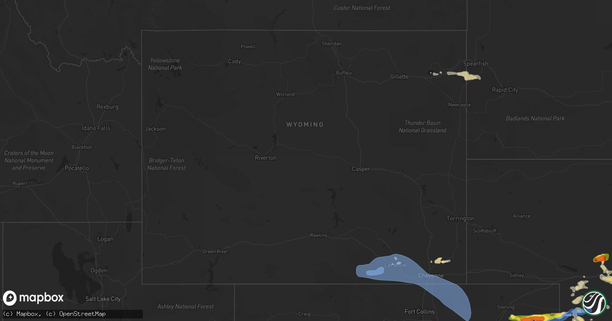
Hail Map in Wyoming on July 13, 2020
Get this storm
July 13 map
$229
one time, instant access
Download today. No call, no setup
Keep the $229
Bought the map and want the full workflow? Apply the entire $229 to a subscription within 7 days. None of it is wasted.
Every map, not just this one
This buys you this map. Subscription and you get every map we run, in the markets you choose from a few cities to whole states to nationwide. Plus real-time alerts the moment a storm fires.
Contact data
Name, contact info, occupancy, even credit band for addresses in the footprint. You go from where it hit to who to call.
Become the source they trust
Unlimited branding weather history reports on demand. You already have the documented answer ready for the property owner, and you are the one who showed up with it.
Property data and RoofTrace estimates
Pull up any address you have got, its value and the exact code rules for that jurisdiction, straight from One Click Code. Then RoofTrace estimates the squares, pitch, and roof value, priced the way you price.
Storm reports in Wyoming
Wyoming
| Date | Description |
|---|---|
| 07/13/20205:28 PM CDT | Corrects previous tstm wnd gst report from 1 nw cheyenne. Cheyenne airport wind gust 61mph. |
| 07/13/20205:24 PM CDT | I80/us30. |
| 07/13/20205:16 PM CDT | I80/us30. |
| 07/13/20205:12 PM CDT | I80/us30 - otto. |
| 07/13/20205:10 PM CDT | Id: up226 name: emkayw. |
| 07/13/20205:10 PM CDT | Wy210 - wildcat trail. |
| 07/13/20205:04 PM CDT | Corrects previous tstm wnd gst report from 3 ne pumpkin vine. Dalews. |
| 07/13/20204:55 PM CDT | Upr site 60mph mesonet wind gust. |
| 07/13/20204:53 PM CDT | Asos station klar laramie airport - lar. |
| 07/13/20204:52 PM CDT | Mesonet station kvdw vedauwoo |
| 07/13/20204:52 PM CDT | Mesonet station wy36 2.4 nw buford |
| 07/13/20204:42 PM CDT | Mesonet station kpum pumpkin vine |
| 07/13/20204:30 PM CDT | Mesonet station fw4449 laramie. |
| 07/13/20204:06 PM CDT | Corrects previous tstm wnd gst report from 3 nw arlington. I80 - foote creek. |
| 07/13/20204:06 PM CDT | . |
| 07/13/20203:56 PM CDT | Mesonet station kskl skyline |
| 07/13/20203:43 PM CDT | Cow creek. |
| 07/13/20203:26 PM CDT | Mesonet station wy18 6.8 nw elk mountain |
| 07/13/20203:16 PM CDT | Corrects previous non-tstm wnd gst report from 9 wnw elk mountain. Mesonet station wy17 8.9 s hanna |
| 07/13/20203:06 PM CDT | Mesonet station wy15 14.5 e sinclair |
| 07/13/20205:49 AM CDT | At 1049 PM MDT, a severe thunderstorm was located 4 miles north of O'Neil Pass, or 12 miles southwest of Lead, moving east at 60 mph. HAZARD...60 mph wind gusts and quarter size hail. SOURCE...Radar indicated. IMPACT...Hail damage to vehicles is expected. Expect wind damage to roofs, siding, and trees. This severe thunderstorm will be near... Cheyenne Crossing and Terry Peak around 1055 PM MDT. Lead, Deadwood and Central City around 1100 PM MDT. Brownsville, Galena and Roubaix Lake around 1105 PM MDT. Nemo, Tilford and Dalton Lake around 1115 PM MDT. Summerset and Piedmont around 1120 PM MDT. Black Hawk around 1125 PM MDT. Ellsworth Air Force Base around 1135 PM MDT.This includes Interstate 90 in South Dakota between Mile Markers 36and 59, and between Mile Markers 62 and 76. |
| 07/12/202011:16 PM CDT | At 416 PM MDT, severe thunderstorms were located along a line extending from 6 miles southeast of South Greeley to near Berthoud, or along a line extending from 8 miles southeast of Cheyenne to 18 miles south of Fort Collins, moving east at 45 mph. HAZARD...60 mph wind gusts. SOURCE...Radar indicated. IMPACT...Expect damage to roofs, siding, and trees. Locations impacted include... Eastern Fort Collins, Greeley, eastern Loveland, Windsor, Evans, Johnstown, Milliken, Berthoud, Eaton, Mead, Severance, LaSalle, Ault, Kersey, Gilcrest, Pierce, Timnath, Nunn, Grover and Purcell. |
| 07/12/202010:41 PM CDT | At 340 PM MDT, severe thunderstorms were located along a line extending from near Bosler to 10 miles north of Red Feather Lakes, moving northeast at 45 mph. HAZARD...70 mph wind gusts and penny size hail. SOURCE...Radar indicated. IMPACT...Expect considerable tree damage. Damage is likely to mobile homes, roofs, and outbuildings. Locations impacted include... Laramie, Tie City Campground, Vedauwoo, Bosler, Federal, Tie Siding, University Of Wyoming War Memorial Stadium, Crystal Lake Reservoir, Pumpkin Vine, Crystal Lake Campground, Vedauwoo Campground, Buford, Granite Springs Reservoir, North Crow Campground, Iron Mountain, Baldy Peak, Granite Springs Campground, Horse Creek, The Buttes and Hutton Lake.This includes Interstate 80 in Wyoming between mile markers 304 and354. |
| 07/12/202010:36 PM CDT | At 335 PM MDT, severe thunderstorms were located along a line extending from 11 miles south of Hutton Lake to 6 miles west of Buckhorn Mountain to near Allenspark, or along a line extending from 22 miles south of Laramie to 20 miles west of Fort Collins to 43 miles northwest of Denver, moving east at 45 mph. HAZARD...60 mph wind gusts. SOURCE...Radar indicated. IMPACT...Expect damage to roofs, siding, and trees. Locations impacted include... Fort Collins, Greeley, Longmont, Loveland, Windsor, Evans, Firestone, Johnstown, Wellington, Estes Park, Milliken, Berthoud, Eaton, Mead, Severance, Platteville, Lyons, LaSalle, Ault and Gilcrest. |
| 07/12/202010:00 PM CDT | At 259 PM MDT, severe thunderstorms were located along a line extending from 3 miles southeast of Six Mile Campground to 6 miles northwest of Granby, or along a line extending from 45 miles southwest of Laramie to 57 miles southwest of Fort Collins, moving east at 45 mph. HAZARD...60 mph wind gusts. SOURCE...Radar indicated. IMPACT...Expect damage to roofs, siding, and trees. Locations impacted include... Estes Park, Trail Ridge, Bear Lake, Walden, Grand Lake, Lake John, Raymond, Rand, Allenspark, Red Feather Lakes, Brownlee, Rustic, Longs Peak, Cowdrey, Glendevey, Pingree Park, Pearl, Cameron Pass, Glen Haven and Four Corners. |
| 07/12/20209:26 PM CDT | At 225 PM MDT, a severe thunderstorm was located near Elk Mountain, or 46 miles northwest of Laramie, moving east at 35 mph. HAZARD...70 mph wind gusts. SOURCE...Radar indicated. IMPACT...Expect considerable tree damage. Damage is likely to mobile homes, roofs, and outbuildings. Locations impacted include... Elk Mountain and Arlington. This includes Interstate 80 in Wyoming between mile markers 251 and279. |
All States Impacted by Hail Map on July 13, 2020
Cities Impacted by Hail Map on July 13, 2020
- Deadwood, SD
- Sundance, WY
- Lead, SD
- Purdum, NE
- Brewster, NE
- Saint Francis, KS
- Colby, KS
- Goodland, KS
- Benkelman, NE
- Yuma, CO
- Haxtun, CO
- Holyoke, CO
- Rockingham, NC
- Maple Hill, NC
- Bemidji, MN
- Laporte, MN
- Cass Lake, MN
- Lake George, MN
- Winona, KS
- Burlington, CO
- Edson, KS
- Weskan, KS
- Cando, ND
- Cheyenne, WY
- Sharon Springs, KS
- Cambridge, NE
- Chesterfield, SC
- Saint Johns, AZ
- Galivants Ferry, SC
- Gresham, SC
- Conway, SC
- Aynor, SC
- New Bern, NC
- Fleming, CO
- Otis, CO
- Mcalester, OK
- Wayne, NE
- Bricelyn, MN
- Loris, SC
- Longs, SC
- Sterling, CO
- Burwell, NE
- Amelia, NE
- Chambers, NE
- Hill City, KS
- Stuart, NE
- Indianola, NE
- Culbertson, NE
- McCook, NE
- Parks, NE
- Seven Springs, NC
- Andrews, SC
- Georgetown, SC
- Munich, ND
- Taylor, NE
- Krebs, OK
- Stratton, NE
- Trenton, NE
- Laramie, WY
- Maywood, NE
- Imperial, NE
- New Raymer, CO
- Spalding, NE
- Norfolk, NE
- Myrtle Beach, SC
- Maple, NC
- Barco, NC
- Egeland, ND
- Starkweather, ND
- Tryon, NE
- Sutherland, NE
- North Platte, NE
- Hershey, NE
- Enders, NE
- Vancleave, MS
- Stratton, CO
- Indianola, OK
- Dalhart, TX
- Ericson, NE
- Bluffton, MN
- Wadena, MN
- New York Mills, MN
- Sebeka, MN
- Verndale, MN
- Sinton, TX
- Taft, TX
- Maysville, NC
- Wallace, KS
- Rocklake, ND
- Middlesex, NC
- Wallace, SC
- Society Hill, SC
- Burns, WY
- Wolford, ND
- Rugby, ND
- Eagle Bend, MN
- Idalia, CO
- Polkton, NC
- Wadesboro, NC
- Bethune, CO
- Raleigh, NC
- Willow Spring, NC
- Lexington, NE
- Leoti, KS
- Long Prairie, MN
- Clarissa, MN
- Miltona, MN
- Browerville, MN
- Parkers Prairie, MN
- Atkinson, NE
- Long Pine, NE
- Pollocksville, NC
- Randall, MN
- Maxwell, NE
- Hoxie, KS
- Jacksonville, NC
- Oneill, NE
- Quinn, SD
- Philip, SD
- Wall, SD
- Goldsboro, NC
- La Grange, NC
- Bagley, MN
- Oberlin, KS
- Wellfleet, NE
- Nisswa, MN
- Pillager, MN
- South Tamworth, NH
- Center Sandwich, NH
- North Sandwich, NH
- Moultonborough, NH
- Blackduck, MN
- Bogue, KS
- Arapahoe, CO
- Hayes Center, NE
- Hendley, NE
- Wilsonville, NE
- Norton, KS
- Champion, NE
- Cozad, NE
- Eustis, NE
- Jamestown, SC
- Newbury, VT
- Broadway, NC
- Wallace, NE
- Brookville, KS
- Fuquay Varina, NC
- South Strafford, VT
- Lyme, NH
- Piermont, NH
- Post Mills, VT
- Fairlee, VT
- Thetford Center, VT
- Orford, NH
- West Fairlee, VT
- Bradford, VT
- Oakley, KS
- Wray, CO
- Haigler, NE
- Tribune, KS
- Springfield, CO
- Pierce, NE
- Wauneta, NE
- Etna, NH
- Lebanon, NH
- Hanover, NH
- Enfield, NH
- Little Falls, MN
- Campton, NH
- Holderness, NH
- Baker, FL
- Edenton, NC
- Brewster, KS
- Grant, NE
- Grinnell, KS
- Apex, NC
- Garner, NC
- Atwood, OK
- Holdenville, OK
- New Iberia, LA
- Loreauville, LA
- Box Elder, SD
- New Underwood, SD
- Piedmont, SD
- Sturgis, SD
- Magnolia, NC
- Clearwater, NE
- Ewing, NE
- Wood Lake, NE
- Canaan, NH
- West Lebanon, NH
- Rumney, NH
- Bethune, SC
- Granite Canon, WY
- Tie Siding, WY
- Meadow Grove, NE
- Battle Creek, NE
- Mount Olive, NC
- Florence, SC
- Langdon, ND
- Pierz, MN
- Hillman, MN
- Springview, NE
- Farnam, NE
- Orrum, NC
- Fairmont, NC
- Petersburg, NE
- Tilden, NE
- Morland, KS
- Winside, NE
- Lancaster, MN
- Dunning, NE
- Elwood, NE
- Curtis, NE
- Moorefield, NE
- Brady, NE
- Fosston, MN
- Lengby, MN
- Hackensack, MN
- Danbury, NE
- Jeanerette, LA
- Emerald Isle, NC
- Greeley, NE
- Bassett, NE
- Bird City, KS
- Stockton, KS
- Conway, NC
- Marion, SC
- Levant, KS
- Kanorado, KS
- Wingate, NC
- Monroe, NC
- Frost, MN
- Blue Earth, MN
- Linden, NC
- Bunnlevel, NC
- Staples, MN
- Swansboro, NC
- Ainsworth, NE
- Wells, MN
- Madrid, NE
- Anacoco, LA
- Osnabrock, ND
- Bladenboro, NC
- Naper, NE
- Cove City, NC
- Lebanon, NE
- Mylo, ND
- Wales, ND
- Waves, NC
- Herndon, KS
- Elgin, NE
- Mathis, TX
- Maple, WI
- Stuart, OK
- Alsen, ND
- Aldrich, MN
- Moorcroft, WY
- Tabor City, NC
- Penokee, KS
- Bartley, NE
- Mount Croghan, SC
- Peachland, NC
- Ruby, SC
- Vilas, CO
- Walsh, CO
- Walker, MN
- Saint Martinville, LA
- Bison, KS
- Otis, KS
- Longville, MN
- Marston, NC
- Laurel Hill, NC
- Smithfield, NC
- Campo, CO
- Elmore, MN
- Neligh, NE
- Grainfield, KS
- Colfax, WI
- Chippewa Falls, WI
- North Haverhill, NH
- Plymouth, NH
- Dustin, OK
- Lamar, OK
- Swanville, MN
- Cushing, MN
- Pittsburg, OK
- Cut Off, LA
- Ogallala, NE
- Lenora, KS
- Great Bend, KS
- Albert, KS
- McDonald, KS
- Sneads Ferry, NC
- Holly Ridge, NC
- Black Hawk, SD
- Nemo, SD
- Valentine, NE
- Leeds, ND
- Elm Creek, NE
- Woodland, NC
- Murfreesboro, NC
- Thornton, NH
- Sanford, NC
- Hoskins, NE
- Nichols, SC
- Bennettsville, SC
- Snowflake, AZ
- Hobucken, NC
- Dover, NC
- Cedar Island, NC
- Thibodaux, LA
- Currituck, NC
- Fairmont, MN
- Swea City, IA
- Armstrong, IA
- Granada, MN
- Elizabethtown, NC
- Park Rapids, MN
- Plainview, NE
- Brunswick, NE
- Royalton, MN
- Park, KS
- Spencer, NE
- Stockville, NE
- Trenton, NC
- Gilman, WI
- Clayton, NC
- Shawboro, NC
- Wewoka, OK
- White River Junction, VT
- Plainfield, NH
- North Hartland, VT
- Mobile, AL
- Johnstown, NE
- Winner, SD
- Elsie, NE
- Ernul, NC
- Bloomer, WI
- Ellsworth, KS
- Paxton, NE
- La Crosse, KS
- Mission, SD
- Vandemere, NC
- Arapahoe, NE
- Upton, WY
- McDavid, FL
- Perham, MN
- Ottertail, MN
- Overton, NE
- Fayetteville, NC
- Corrales, NM
- Bernalillo, NM
- Albuquerque, NM
- Algodones, NM
- Rio Rancho, NM
- Laguna, NM
- Cubero, NM
- Casa Blanca, NM
- Gem, KS
- Nunn, CO
- Briggsdale, CO
- Weldona, CO
- Orchard, CO
- Carpenter, WY
- Fe Warren Afb, WY
- Carr, CO
- Buford, WY
- Grover, CO
- Ault, CO
- Jelm, WY
- Hereford, CO
- Centennial, WY
- Wellington, CO
- Vona, CO
- Dunbarton, NH
- Bow, NH


