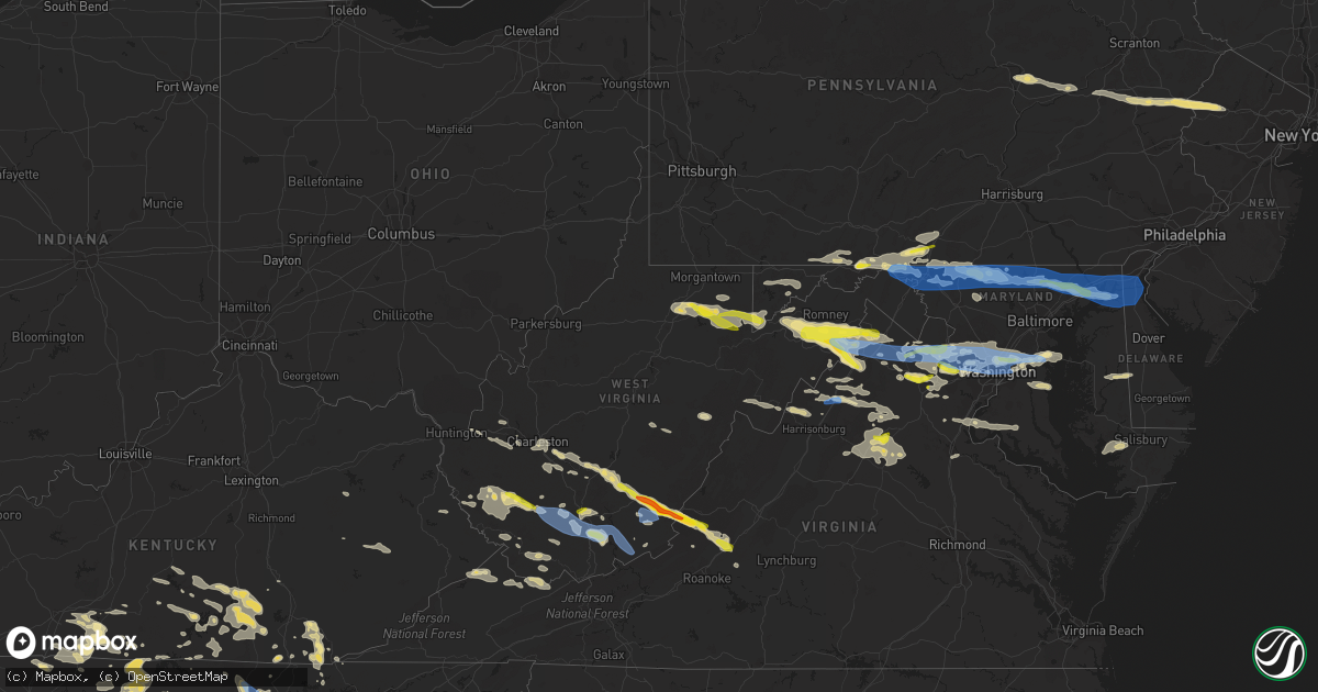
Hail Map in West Virginia on July 12, 2022
Get this storm
July 12 map
$229
one time, instant access
Download today. No call, no setup
Keep the $229
Bought the map and want the full workflow? Apply the entire $229 to a subscription within 7 days. None of it is wasted.
Every map, not just this one
This buys you this map. Subscription and you get every map we run, in the markets you choose from a few cities to whole states to nationwide. Plus real-time alerts the moment a storm fires.
Contact data
Name, contact info, occupancy, even credit band for addresses in the footprint. You go from where it hit to who to call.
Become the source they trust
Unlimited branding weather history reports on demand. You already have the documented answer ready for the property owner, and you are the one who showed up with it.
Property data and RoofTrace estimates
Pull up any address you have got, its value and the exact code rules for that jurisdiction, straight from One Click Code. Then RoofTrace estimates the squares, pitch, and roof value, priced the way you price.
Storm reports in West Virginia
West Virginia
| Date | Description |
|---|---|
| 07/12/20226:49 PM CDT | Numerous trees down around augusta near route 50 and ford hill road. |
| 07/12/20226:09 PM CDT | One tree down on indian mills rd. Time estimated by radar. |
| 07/12/20226:06 PM CDT | One tree down on dry fork run. Time estimated by radar. |
| 07/12/20225:52 PM CDT | Pea to quarter sized hail. Time based on radar. |
| 07/12/20225:49 PM CDT | Two trees down on i-64 east. Location approximate. Time based on radar. |
| 07/12/20225:42 PM CDT | A local report indicates 1.25 inch wind near 2 WNW ELLISON |
| 07/12/20225:34 PM CDT | Trees and powerlines down on a truck along route 219 near the greenbrier county line. No injuries. |
| 07/12/20225:33 PM CDT | Thunderstorm winds blew many twigs down and also three to four limbs of wrist size diameter. Time estimated from radar. |
| 07/12/20225:32 PM CDT | A local report indicates 1.75 inch wind near 2 NE LEWISBURG |
| 07/12/20225:32 PM CDT | Trees and powerlines down on midland trail east of lewisburg. |
| 07/12/20225:30 PM CDT | A local report indicates 1.00 inch wind near 3 S MAXWELTON |
| 07/12/20225:28 PM CDT | High voltage power lines were blown down which shutdown i-64 for over an hour. Time estimated by radar. |
| 07/12/20225:27 PM CDT | Tree down on flat top rd. |
| 07/12/20225:23 PM CDT | Tree down at whitby rd and coal city rd. |
| 07/12/20225:21 PM CDT | Tree down 4000 block of odd rd. |
| 07/12/20225:21 PM CDT | Multiple trees down on coal city rd. |
| 07/12/20225:21 PM CDT | Tree down 800 block of shawnee ct. |
| 07/12/20225:18 PM CDT | Multiple trees down near alta. |
| 07/12/20225:15 PM CDT | Damage to roof and vehicles. |
| 07/12/20225:08 PM CDT | A local report indicates 1.00 inch wind near 2 NNW MABSCOTT |
| 07/12/20224:55 PM CDT | Multiple trees down in fayetteville. |
| 07/12/20224:55 PM CDT | Tree down on poplar gap rd. Time estimated by radar. |
| 07/12/20224:51 PM CDT | 2 trees down on rt. 85 in kopperston. |
| 07/12/20224:47 PM CDT | Multiple trees down in oak hill. |
| 07/12/20224:39 PM CDT | A local report indicates 1.00 inch wind near 5 ENE MITCHELL HEIGHTS |
| 07/12/20224:39 PM CDT | Tree and power lines down on perry branch rd in chapmanville. |
| 07/12/20224:28 PM CDT | Multiple trees down in montgomery. |
| 07/12/20224:21 PM CDT | Tree down at cabin creek rd and creek ln. |
| 07/12/20224:21 PM CDT | Tree down at cabin creek rd and wealthy acres rd. |
| 07/12/20224:10 PM CDT | Tree down at cabin creek rd and wealthy acres rd. Time is estimated by radar. |
| 07/12/20224:10 PM CDT | Tree down at cabin creek rd and creek ln. Time is estimated by radar. |
| 07/12/20224:05 PM CDT | Tree down at hannan trace rd and glenwood rd. |
| 07/12/20224:03 PM CDT | 2 trees down on maccorkle avenue in marmet. |
| 07/12/20223:52 PM CDT | 2 trees down on maccorkle avenue in marmet. Time is radar estimated. |
| 07/12/20223:48 PM CDT | Tree down on cane fork rd. |
| 07/12/20223:45 PM CDT | Numerous trees down including some on structures. |
| 07/12/20223:24 PM CDT | Tree down. |
| 07/12/20223:12 PM CDT | 2 trees down in the area. |
| 07/12/20223:12 PM CDT | 2 trees down on hickory road. |
| 07/12/20223:05 PM CDT | Tree down at hannan trace rd and glenwood rd. |
| 07/12/20223:02 PM CDT | Tree down. |
| 07/12/20223:00 PM CDT | A local report indicates 1.00 inch wind near 3 SSE WARDENSVILLE |
| 07/12/20222:59 PM CDT | A tree blew down near the 8800 block of back creek rd. |
| 07/12/20222:58 PM CDT | Multiple trees and large branches snapped. |
| 07/12/20222:57 PM CDT | Numerous trees down in wardensville. |
| 07/12/20222:55 PM CDT | Numerous trees down around capon springs. Trees on roadways shut down multiple roads in the area. |
| 07/12/20222:52 PM CDT | Numerous trees down around delray. Trees on roadways shut down multiple roads in the area. |
| 07/12/20222:52 PM CDT | Tree reported down on upper patterson creek road near seymoursville road. |
| 07/12/20222:50 PM CDT | A few trees down around the city of petersburg. |
| 07/12/20222:49 PM CDT | Numerous trees down around augusta near route 50 and ford hill road. |
| 07/12/20222:49 PM CDT | Downed trees damaging a tin shed. |
| 07/12/20222:47 PM CDT | A tree blew down near the 730 block of tanager trail. |
| 07/12/20222:47 PM CDT | Numerous trees down in rio. |
| 07/12/20222:46 PM CDT | Tree down along ford hill road. |
| 07/12/20222:43 PM CDT | A tree blew down near the 12500 block of grassy lick rd. |
| 07/12/20222:41 PM CDT | Multiple trees down along hemlock dr and old popular dr |
| 07/12/20222:41 PM CDT | Tree reported down on the 4700 block of jordan run road. |
| 07/12/20222:40 PM CDT | Tree down. |
| 07/12/20222:36 PM CDT | Tree down. Time is radar estimate. |
| 07/12/20222:34 PM CDT | Tree down. |
| 07/12/20222:34 PM CDT | Power line down. Possibly struck by lightning. |
| 07/12/20222:34 PM CDT | Local law enforcement reported a tree down on crooked creek rd. Time is estimated by radar. |
| 07/12/20222:28 PM CDT | Tree reported down on greenland gap road near upper patterson creek road. |
| 07/12/20222:26 PM CDT | Tree reported down knobley road near buck ridge lane. |
| 07/12/20222:24 PM CDT | A tree blew down near knobley rd and buck ridge ln. |
| 07/12/20222:22 PM CDT | Multiple trees down along greenland gap road. |
| 07/12/20222:20 PM CDT | A tree blew down near the 4100 block of laurel dale rd. |
| 07/12/20222:20 PM CDT | Tree down in the 4100 block of laurel dale road. |
| 07/12/20222:09 PM CDT | Tree and wires down in fort ashby. |
| 07/12/20222:05 PM CDT | Tree down at hannan trace rd and glenwood rd. |
| 07/12/20222:02 PM CDT | Multiple trees down in the area just west of mt. Storm. |
| 07/12/20221:54 PM CDT | A combination of large branches and down trees along state route 72 |
| 07/12/20221:52 PM CDT | Two trees down along state route 72 |
| 07/12/20221:51 PM CDT | Several large limbs and one tree down on shower bath road |
| 07/12/20221:50 PM CDT | Trees down in the area of dogwood flats... Including one down on a power line. |
| 07/12/20221:46 PM CDT | Tree down on webster pike. Time is radar estimate. |
| 07/12/20221:37 PM CDT | Tree down on iron town road in thornton. |
| 07/12/20221:37 PM CDT | Tree down on w veterans memorial highway in rosemont. Time is radar estimate. |
| 07/12/20221:32 PM CDT | Tree down on w veterans memorial highway in rosemont. |
| 07/12/20221:30 PM CDT | Report of trees down throughout the county... Including several in the area of the route 26 and 50. |
| 07/12/20221:20 PM CDT | Report of trees down throughout the county... Including bottom of and crossing route 7 near the cheat river. |
| 07/12/20221:18 PM CDT | Tree down knottsville road. |
| 07/12/20221:05 PM CDT | Tree down on beverly pike. |
| 07/12/20221:04 PM CDT | Tree down on laurel run road. |
| 07/12/20221:32 AM CDT | At 631 PM EDT, a severe thunderstorm was located near Flat Top, or 10 miles north of Camp Creek, moving east at 30 mph. HAZARD...70 mph wind gusts and quarter size hail. SOURCE...Radar indicated. IMPACT...Hail damage to vehicles is expected. Expect considerable tree damage. Wind damage is also likely to mobile homes, roofs, and outbuildings. Locations impacted include... Princeton... Narrows... Athens... Peterstown... Camp Creek... Pipestem... and Rich Creek. |
| 07/12/202212:59 AM CDT | At 558 PM EDT, a severe thunderstorm was located near Bald Knob, or 13 miles north of Pineville, moving east-southeast at 40 mph. HAZARD...60 mph wind gusts and nickel size hail. SOURCE...Radar indicated. IMPACT...Expect damage to roofs, siding, and trees. Locations impacted include... Beckley, Mullens, Mabscott, Oceana, Sophia, Crab Orchard, Dry Creek, Macarthur, Coal City, Shady Spring, Twin Falls State Park, Beaver, Daniels, Lester, Rhodell, Naoma, Bolt, Arnett, Kopperston and Glen Daniel.This includes the following highways... West Virginia Turnpike between mile markers 30 and 45. Interstate 64 in West Virginia between mile markers 120 and 126. |
| 07/12/202212:35 AM CDT | At 534 PM EDT, severe thunderstorms were located along a line extending from near Summersville to 7 miles northwest of Mount Hope, moving east-southeast at 50 mph. HAZARD...60 mph wind gusts and quarter size hail. SOURCE...Radar indicated. IMPACT...Hail damage to vehicles is expected. Expect wind damage to roofs, siding, and trees. Locations impacted include... Summersville, Fayetteville, Richwood, Babcock State Park, Oak Hill, Mount Hope, Meadow Bridge, Pax, Thurmond, Canvas, Nettie and Mount Nebo.This includes the following highways... West Virginia Turnpike between mile markers 54 and 59. Route 19 between mile markers 5 and 39. |
| 07/12/202212:31 AM CDT | At 531 PM EDT, a severe thunderstorm was located near Logan, moving east at 35 mph. HAZARD...60 mph wind gusts and half dollar size hail. SOURCE...Radar indicated. IMPACT...Hail damage to vehicles is expected. Expect wind damage to roofs, siding, and trees. Locations impacted include... Logan, Oceana, Man, Mallory, Amherstdale-Robinette, Wharton, Bald Knob, Mount Gay-Shamrock, Holden, West Logan, Mitchell Heights, Mount Gay, Cyclone, Naoma, Arnett, Kopperston, Stickney, Blair, Amherstdale-Robine and Sharples.This includes Route 119 between mile markers 43 and 45. |
| 07/12/202212:03 AM CDT | At 502 PM EDT, severe thunderstorms were located along a line extending from near Ansted to near Burnwell, moving southeast at 35 mph. HAZARD...60 mph wind gusts and penny size hail. SOURCE...Law enforcement. Many reports of downed trees and power lines have been reported with this line of storms. IMPACT...Expect damage to roofs, siding, and trees. Locations impacted include... Beckley, Fayetteville, Babcock State Park, Oak Hill, Montgomery, Mount Hope, Mabscott, Ansted, Smithers, Gauley Bridge, Pratt, Dry Creek, Macarthur, Bradley, Powellton, Hawks Nest State Park, Beaver, Piney View, Stanaford and Prosperity.This includes the following highways... West Virginia Turnpike between mile markers 37 and 39, and betweenmile markers 41 and 80. Interstate 64 in West Virginia between mile markers 120 and 129. |
| 07/11/202211:37 PM CDT | At 436 PM EDT, severe thunderstorms were located along a line extending from near Cedar Grove to 7 miles southwest of Marmet, moving east at 35 mph. HAZARD...60 mph wind gusts and penny size hail. SOURCE...Radar indicated. IMPACT...Expect damage to roofs, siding, and trees. Locations impacted include... Charleston, Fayetteville, Montgomery, Chesapeake, Marmet, Ansted, Belle, Cedar Grove, East Bank, Glasgow, Smithers, Gauley Bridge, Pratt, Powellton, Hawks Nest State Park, Coal Fork, Burnwell, Handley, Seth and Dawes.This includes the following highways... Interstate 77 in West Virginia between mile markers 96 and 98. West Virginia Turnpike between mile markers 61 and 95. |
| 07/11/202211:10 PM CDT | At 409 PM EDT, severe thunderstorms were located along a line extending from near Cross Lanes to near Hamlin, moving east at 30 mph. HAZARD...60 mph wind gusts and penny size hail. SOURCE...Radar indicated. IMPACT...Expect damage to roofs, siding, and trees. Locations impacted include... Charleston, Nitro, Jefferson, South Charleston, St. Albans, Dunbar, Sissonville, Chesapeake, Marmet, Belle, Poca, Cross Lanes, Pinch, Alum Creek, Glen, Institute, Tornado, Coal Fork, Elkview and Teays Valley.This includes the following highways... Interstate 79 between mile markers 1 and 10. Interstate 77 in West Virginia between mile markers 96 and 111. Interstate 64 in West Virginia between mile markers 44 and 57. West Virginia Turnpike between mile markers 87 and 95. |
| 07/11/202210:59 PM CDT | At 359 PM EDT, a severe thunderstorm was located near Wardensville, or 9 miles northwest of Woodstock, moving east at 55 mph. HAZARD...60 mph wind gusts and quarter size hail. SOURCE...Radar indicated. IMPACT...Damaging winds will cause some trees and large branches to fall. This could injure those outdoors, as well as damage homes and vehicles. Roadways may become blocked by downed trees. Localized power outages are possible. Unsecured light objects may become projectiles. Locations impacted include... Front Royal, Strasburg, Woodstock, Linden, Chester Gap, Maurertown, Toms Brook, Fort Valley, Arco, Seven Fountains, Dilbeck, Harmony, Alonzaville, Riverton, Karo, Glen Echo, Perry, Bentonville, Fishers Hill and Browntown. |
| 07/11/202210:46 PM CDT | At 346 PM EDT, severe thunderstorms were located along a line extending from Winfield to near Culloden, moving east at 30 mph. HAZARD...60 mph wind gusts. SOURCE...Radar indicated. IMPACT...Expect damage to roofs, siding, and trees. Locations impacted include... Charleston, Nitro, Winfield, Jefferson, South Charleston, St. Albans, Dunbar, Hurricane, Sissonville, Milton, Eleanor, Poca, Cross Lanes, Culloden, Alum Creek, Institute, Tornado, Amma, Teays Valley and Elkview.This includes the following highways... Interstate 79 between mile markers 1 and 26. Interstate 77 in West Virginia between mile markers 100 and 116. Interstate 64 in West Virginia between mile markers 29 and 57. |
| 07/11/202210:22 PM CDT | At 322 PM EDT, a severe thunderstorm was located near Claylick, or 12 miles west of Hagerstown, moving east at 40 mph. HAZARD...60 mph wind gusts and quarter size hail. SOURCE...Radar indicated. IMPACT...Damaging winds will cause some trees and large branches to fall. This could injure those outdoors, as well as damage homes and vehicles. Roadways may become blocked by downed trees. Localized power outages are possible. Unsecured light objects may become projectiles. Locations impacted include... Hagerstown, Thurmont, Municipal Stadium, Robinwood, Fountainhead-Orchard Hills, Smithsburg, Paramount-Long Meadow, Wilson-Conococheague, Williamsport, Mount Aetna, Mount Lena, San Mar, Long Meadow, Wolfsville, Saint James, Halfway, Maugansville, Cavetown, Funkstown and Falling Waters. |
| 07/11/202210:16 PM CDT | At 316 PM EDT, a severe thunderstorm was located near Eleanor, or near Winfield, moving east at 35 mph. HAZARD...60 mph wind gusts and nickel size hail. SOURCE...Radar indicated. IMPACT...Expect damage to roofs, siding, and trees. Locations impacted include... Charleston, Nitro, Winfield, Jefferson, South Charleston, St. Albans, Dunbar, Hurricane, Sissonville, Eleanor, Buffalo, Poca, Cross Lanes, Institute, Teays Valley, Bancroft, Liberty and Fraziers Bottom.This includes the following highways... Interstate 79 between mile markers 1 and 4. Interstate 77 in West Virginia between mile markers 98 and 119. Interstate 64 in West Virginia between mile markers 35 and 57. |
| 07/11/202210:00 PM CDT | At 300 PM EDT, a severe thunderstorm was located over Barnes Gap, or 11 miles west of Hancock, moving east at 40 mph. HAZARD...60 mph wind gusts and quarter size hail. SOURCE...Radar indicated. IMPACT...Damaging winds will cause some trees and large branches to fall. This could injure those outdoors, as well as damage homes and vehicles. Roadways may become blocked by downed trees. Localized power outages are possible. Unsecured light objects may become projectiles. Locations impacted include... Hancock, Berkeley Springs, Clear Spring, Pecktonville, Big Spring, Big Pool, Cherry Run, Spohrs Crossroads, Spruce Pine Hollow, Forest Park, Bellegrove, Sleepy Creek and Shady Grove. |
| 07/11/20229:28 PM CDT | At 228 PM EDT, a severe thunderstorm was located near Grafton, moving east at 35 mph. HAZARD...60 mph wind gusts and half dollar size hail. SOURCE...Radar indicated. IMPACT...Hail damage to vehicles is expected. Expect wind damage to roofs, siding, and trees. Locations impacted include... Grafton, Knottsville, Moatsville, Tygart Lake State Park, Thornton and Nestorville. |
| 07/11/20229:02 PM CDT | At 202 PM EDT, a severe thunderstorm was located near Shinnston, or 8 miles northeast of Clarksburg, moving east at 35 mph. HAZARD...60 mph wind gusts and quarter size hail. SOURCE...Radar indicated. IMPACT...Hail damage to vehicles is expected. Expect wind damage to roofs, siding, and trees. Locations impacted include... Clarksburg, Grafton, Bridgeport, Shinnston, Lumberport, Anmoore, Enterprise, Flemington, Moatsville, Rosemont, Knottsville, Meadland, Tygart Lake State Park, Thornton, McGee, Meadowbrook and Despard.This includes the following highways... Interstate 79 between mile markers 119 and 128. Route 50 in West Virginia between mile markers 77 and 79, andbetween mile markers 81 and 82. |
| 07/11/20228:52 PM CDT | At 152 PM EDT, severe thunderstorms were located along a line extending from near Mount Davis to near Brookhaven, moving east at 35 mph. HAZARD...60 mph wind gusts and quarter size hail. SOURCE...Radar indicated. IMPACT...Damaging winds will cause some trees and large branches to fall. This could injure those outdoors, as well as damage homes and vehicles. Roadways may become blocked by downed trees. Localized power outages are possible. Unsecured light objects may become projectiles. Locations impacted include... Oakland, Bittinger, Grantsville, Friendsville, Deer Park, Accident, Merrill, Hutton, Keysers Ridge, Jennings, Mineral Spring, Deep Creek Lake State Park, Swallow Falls State Park, McHenry, Selbysport, Big Run State Park, New Germany, Piney Grove and McComas Beach. |
All States Impacted by Hail Map on July 12, 2022
Cities Impacted by Hail Map on July 12, 2022
- Verndale, MN
- Aldrich, MN
- Staples, MN
- Pierz, MN
- Climax, NY
- Coxsackie, NY
- Deer River, MN
- Briggsdale, CO
- East Meredith, NY
- Treadwell, NY
- Delhi, NY
- New Raymer, CO
- Mathias, WV
- Drums, PA
- Mount Bethel, PA
- Columbia, NJ
- Kunkletown, PA
- Great Meadows, NJ
- Effort, PA
- Andover, NJ
- Portland, PA
- Freeland, PA
- Lake Harmony, PA
- Blairstown, NJ
- Brodheadsville, PA
- Stanhope, NJ
- Albrightsville, PA
- White Haven, PA
- Hazleton, PA
- Weatherly, PA
- Bangor, PA
- Stroudsburg, PA
- East Stroudsburg, PA
- Hackettstown, NJ
- Jim Thorpe, PA
- Saylorsburg, PA
- Hillman, MN
- Foley, MN
- Tracys Landing, MD
- Dunkirk, MD
- Upper Marlboro, MD
- Churchton, MD
- Deale, MD
- Lothian, MD
- Long Eddy, NY
- Hume, VA
- Markham, VA
- Marshall, VA
- Linden, VA
- Akeley, MN
- Walker, MN
- Shady Spring, WV
- Hinton, WV
- Hinton, VA
- Fulks Run, VA
- Singers Glen, VA
- Harrisonburg, VA
- Linville, VA
- Stuyvesant, NY
- Kinderhook, NY
- Danville, PA
- Millville, PA
- Muncy, PA
- Orangeville, PA
- Berwick, PA
- Turbotville, PA
- Watsontown, PA
- Bloomsburg, PA
- Shinnston, WV
- Bridgeport, WV
- Fairmont, WV
- Gormania, WV
- Terra Alta, WV
- Enterprise, WV
- Worthington, WV
- Eglon, WV
- Newburg, WV
- Moatsville, WV
- Oakland, MD
- Tunnelton, WV
- Independence, WV
- Parsons, WV
- Aurora, WV
- Rowlesburg, WV
- Thornton, WV
- Grafton, WV
- Flemington, WV
- Iaeger, WV
- Welch, WV
- Davy, WV
- Kimball, WV
- Chicopee, MA
- Monson, MA
- Hampden, MA
- Springfield, MA
- Indian Orchard, MA
- Southampton, MA
- Holyoke, MA
- Wilbraham, MA
- Wales, MA
- Ludlow, MA
- West Springfield, MA
- Westfield, MA
- Wardensville, WV
- Webster Springs, WV
- Elk Garden, WV
- Keyser, WV
- Lacrosse, WA
- Saint John, WA
- Endicott, WA
- Thornton, WA
- Colfax, WA
- Fayetteville, WV
- Lenore, WV
- Kermit, WV
- Pineville, KY
- Nunn, CO
- Beckley, WV
- Beaver, WV
- Eagle Bridge, NY
- North Bennington, VT
- Cambridge, NY
- Middletown, DE
- Wiggins, CO
- Fort Morgan, CO
- Carr, CO
- Simsbury, CT
- Tariffville, CT
- Bloomfield, CT
- Boonville, NY
- Woodgate, NY
- Forestport, NY
- Hawkins, WI
- Glen Flora, WI
- Stephens City, VA
- Middletown, VA
- Front Royal, VA
- Motley, MN
- Cushing, MN
- Browerville, MN
- Brandywine, WV
- Huntington, WV
- Ona, WV
- Barboursville, WV
- Sterling, CO
- Atwood, CO
- Akron, CO
- Merino, CO
- Medford, WI
- Merriman, NE
- Whitman, NE
- Pequot Lakes, MN
- Brainerd, MN
- Pine River, MN
- Nisswa, MN
- Baxter, MN
- Log Lane Village, CO
- Snyder, CO
- Hillrose, CO
- Brush, CO
- Athens, NY
- Catskill, NY
- Cheyenne, WY
- Glen White, WV
- Lester, WV
- Coal City, WV
- Princewick, WV
- Slab Fork, WV
- Crab Orchard, WV
- Josephine, WV
- Rhodell, WV
- Midway, WV
- Sophia, WV
- Cossayuna, NY
- Argyle, NY
- Schuylerville, NY
- Corinth, NY
- Manchester, VT
- Salem, NY
- Pawlet, VT
- Londonderry, VT
- Greenfield Center, NY
- Manchester Center, VT
- West Rupert, VT
- Arlington, VT
- Saratoga Springs, NY
- West Pawlet, VT
- Peru, VT
- Bondville, VT
- Fort Edward, NY
- Granville, NY
- Porter Corners, NY
- Shushan, NY
- Greenwich, NY
- Jamaica, VT
- Dorset, VT
- East Dorset, VT
- Gansevoort, NY
- East Arlington, VT
- Cody, NE
- Merrifield, MN
- Crosby, MN
- Crosslake, MN
- Lisco, NE
- Suncook, NH
- Goshen, NH
- Epsom, NH
- Lempster, NH
- Contoocook, NH
- Charlestown, NH
- Claremont, NH
- Bradford, NH
- Bow, NH
- Loudon, NH
- Washington, NH
- South Acworth, NH
- Chichester, NH
- Henniker, NH
- Concord, NH
- Newport, NH
- Hillsborough, NH
- Dunbarton, NH
- Acworth, NH
- Warner, NH
- Foster, RI
- Dayville, CT
- Chepachet, RI
- Danielson, CT
- East Killingly, CT
- North Scituate, RI
- Roscoe, NY
- Otis, CO
- Davenport, NY
- West Davenport, NY
- Oneonta, NY
- Davenport Center, NY
- Francestown, NH
- New Boston, NH
- Goffstown, NH
- Weare, NH
- Hooksett, NH
- Auburn, NH
- Manchester, NH
- Greenfield, NH
- Bedford, NH
- Bennington, NH
- Rileyville, VA
- Luray, VA
- Edinburg, VA
- Mount Jackson, VA
- Fort Valley, VA
- Ashford, CT
- Eastford, CT
- Tolland, CT
- Pomfret Center, CT
- Willington, CT
- North Clarendon, VT
- Rutland, VT
- Castleton, VT
- Cuttingsville, VT
- Center Rutland, VT
- Killington, VT
- Bomoseen, VT
- Chittenden, VT
- Florence, VT
- Proctor, VT
- West Rutland, VT
- Pittsford, VT
- Townshend, VT
- Keene, NH
- Sullivan, NH
- Walpole, NH
- Stoddard, NH
- Gilsum, NH
- Westminster, VT
- Alstead, NH
- Antrim, NH
- Marlow, NH
- Nelson, NH
- Chester, VT
- Putney, VT
- Newfane, VT
- Hancock, NH
- Big Indian, NY
- Phoenicia, NY
- Claryville, NY
- Bemidji, MN
- Gurley, NE
- Greenville Junction, ME
- Breeden, WV
- Livingston, TN
- Monticello, MN
- Maple Lake, MN
- Clearwater, MN
- Frederick, MD
- Union Bridge, MD
- Mount Airy, MD
- Jackson, KY
- Clayhole, KY
- Bethel Springs, TN
- Crown City, OH
- Franklin, WV
- Riverton, WV
- Circleville, WV
- Deer Trail, CO
- South Charleston, WV
- Saint Albans, WV
- Tornado, WV
- Michie, TN
- Counce, TN
- Savannah, TN
- Columbia, KY
- Russell Springs, KY
- Rock Creek, WV
- Glen Daniel, WV
- Williamsburg, KY
- Newtonville, NJ
- Mays Landing, NJ
- Denniston, KY
- Frenchburg, KY
- Lascassas, TN
- Woodbury, TN
- Readyville, TN
- Bell Buckle, TN
- Murfreesboro, TN
- Milton, TN
- Bradyville, TN
- Christiana, TN
- Boncarbo, CO
- Weston, CO
- Trinidad, CO
- Union, WV
- Lindside, WV
- Glens Fork, KY
- Jamestown, KY
- Tompkinsville, KY
- Mount Ida, AR
- Red Boiling Springs, TN
- Lafayette, TN
- Pleasant Shade, TN
- Riddleton, TN
- Dixon Springs, TN
- Corinth, MS
- Waynesboro, TN
- Westpoint, TN
- Iron City, TN
- Lawrenceburg, TN
- Collinwood, TN
- Bandy, VA
- North Tazewell, VA
- Jewell Ridge, VA
- Berwind, WV
- Squire, WV
- Little Rock, AR
- Paint Rock, TX
- Eden, TX
- Amarillo, TX
- Valley Spring, TX
- Wartburg, TN
- Oliver Springs, TN
- Great Falls, VA
- Sterling, VA
- Poolesville, MD
- Potomac, MD
- Romney, WV
- Shanks, WV
- Rio, WV
- Morgan City, LA
- Paron, AR
- Benton, AR
- Iliff, CO
- Gloversville, NY
- Franklin, TN
- Monticello, KY
- Corbin, KY
- Ferguson, KY
- Whitley City, KY
- Bethelridge, KY
- Bronston, KY
- Burnside, KY
- Nancy, KY
- Parkers Lake, KY
- Stearns, KY
- Science Hill, KY
- Somerset, KY
- Dunnville, KY
- Eubank, KY
- Liberty, KY
- Windsor, KY
- Chapmanville, WV
- Indian Head, MD
- Nanjemoy, MD
- Schriever, LA
- Cuero, TX
- Llano, TX
- Chantilly, VA
- Aldie, VA
- Woodrow, CO
- Hot Springs Village, AR
- Lonsdale, AR
- Warfordsburg, PA
- Chevy Chase, MD
- Takoma Park, MD
- College Park, MD
- Lanham, MD
- Hyattsville, MD
- Bowie, MD
- Glenn Dale, MD
- Washington, DC
- Greenbelt, MD
- Riverdale, MD
- Silver Spring, MD
- Beltsville, MD
- Chapel Hill, TN
- Ghent, WV
- Jumping Branch, WV
- Cool Ridge, WV
- Nimitz, WV
- Pipestem, WV
- Arrington, TN
- College Grove, TN
- Dequincy, LA
- Starks, LA
- Columbia, TN
- Big Rock, VA
- Grundy, VA
- Mason, TX
- Conway, AR
- Gauley Bridge, WV
- Asbury, WV
- Caldwell, WV
- Eagle Rock, VA
- Buchanan, VA
- Montgomery, WV
- White Sulphur Springs, WV
- Ronceverte, WV
- Pond Gap, WV
- Rainelle, WV
- Hico, WV
- Smoot, WV
- Lewisburg, WV
- Maxwelton, WV
- Belle, WV
- Hugheston, WV
- Fincastle, VA
- Ansted, WV
- Rupert, WV
- Victor, WV
- Blount, WV
- Charmco, WV
- Lookout, WV
- Quinwood, WV
- Williamsburg, WV
- Pratt, WV
- Mammoth, WV
- Cedar Grove, WV
- Lansing, WV
- Crawley, WV
- Danese, WV
- Covington, VA
- Nallen, WV
- Culleoka, TN
- Norman, AR
- Westminster, MD
- Manchester, MD
- Taneytown, MD
- Harts, WV
- Hurricane, WV
- Winfield, WV
- Unionville, TN
- Shelbyville, TN
- Lewisburg, TN
- Eagleville, TN
- Rockvale, TN
- Panhandle, TX
- Holland, KY
- Scottsville, KY
- Weimar, TX
- Austin, KY
- Glasgow, KY
- Fountain Run, KY
- Lucas, KY
- Walsenburg, CO
- Avondale, CO
- Meridianville, AL
- Alderson, WV
- Yorktown, TX
- West Coxsackie, NY
- Menard, TX
- Dyke, VA
- Stanardsville, VA
- Fort Scott, KS
- Adolphus, KY
- Herndon, VA
- Fairdale, WV
- Saxon, WV
- Bolt, WV
- Surveyor, WV
- Delaplane, VA
- Cottontown, TN
- Portland, TN
- Inez, KY
- Tomahawk, KY
- Debord, KY
- Pioneer, TN
- Livingston, KY
- East Bernstadt, KY
- Sherwood, AR
- Lebanon, TN
- Harrogate, TN
- Gray, KY
- Barbourville, KY
- Heidrick, KY
- McLean, VA
- Vienna, VA
- Reston, VA
- Oakpark, VA
- Ruckersville, VA
- Hood, VA
- Orange, VA
- Reva, VA
- Pratts, VA
- Gordonsville, VA
- Madison, VA
- Unionville, VA
- Locust Dale, VA
- Radiant, VA
- Haywood, VA
- Rapidan, VA
- Brightwood, VA
- Somerset, VA
- Aroda, VA
- Leon, VA
- Barboursville, VA
- Rochelle, VA
- Culpeper, VA
- Mayflower, AR
- Arlington, VA
- Delray, WV
- Augusta, WV
- Stafford, VA
- Fredericksburg, TX
- Doss, TX
- Herndon, WV
- Pineville, WV
- New Richmond, WV
- Saulsville, WV
- Cabot, AR
- Jacksonville, AR
- Vilonia, AR
- Romance, AR
- Mount Vernon, AR
- Boston, VA
- Sperryville, VA
- Thurmont, MD
- Emmitsburg, MD
- Sabillasville, MD
- Keymar, MD
- Rocky Ridge, MD
- Rocksprings, TX
- Smiths Grove, KY
- Bowling Green, KY
- Gamaliel, KY
- Oakland, KY
- Westmoreland, TN
- Park City, KY
- Franklin, KY
- Mount Juliet, TN
- Round Hill, VA
- Bluemont, VA
- Granville, TN
- Summertown, TN
- Lynnville, TN
- Ethridge, TN
- Pulaski, TN
- Mount Pleasant, TN
- Smyrna, TN
- Nolensville, TN
- Hancock, MD
- Annapolis, MD
- Crownsville, MD
- Arnold, MD
- Jessieville, AR
- Malvern, AR
- Fletcher, NC
- Etlan, VA
- Mercersburg, PA
- Greencastle, PA
- Denton, MD
- Harrington, DE
- Cordova, MD
- Greenwood, DE
- Greenbrier, AR
- Enola, AR
- Elk Horn, KY
- Campbellsville, KY
- Searcy, AR
- Pine Knot, KY
- Bedford, VA
- Thaxton, VA
- Albany, KY
- Burkesville, KY
- Caryville, TN
- The Plains, VA
- Ewing, VA
- Ozona, TX
- Adamsville, TN
- Valley Head, WV
- New Market, VA
- Quicksburg, VA
- Ashburn, VA
- Leesburg, VA
- Middleburg, VA
- Purcellville, VA
- Chatham, NY
- Maumelle, AR
- North Little Rock, AR
- Lindon, CO
- Anton, CO
- Miami, WV
- Eskdale, WV
- Winifrede, WV
- Hernshaw, WV
- Comfort, WV
- Drybranch, WV
- Hansford, WV
- Cabin Creek, WV
- Gallagher, WV
- Bivalve, MD
- Quantico, MD
- Vienna, MD
- Tyaskin, MD
- Eden, MD
- Nanticoke, MD
- Forest Hill, MD
- Monkton, MD
- Jarrettsville, MD
- Aberdeen, MD
- Bel Air, MD
- Fallston, MD
- Churchville, MD
- Calvin, KY
- Pecks Mill, WV
- Logan, WV
- Lake, WV
- Amherstdale, WV
- Yolyn, WV
- Gainesville, VA
- Warrenton, VA
- Nokesville, VA
- Bristow, VA
- Catharpin, VA
- Manassas, VA
- Haymarket, VA
- Broad Run, VA
- Greensburg, KY
- Grand Chenier, LA
- Fredericksburg, VA
- Cannon, KY
- Middlesboro, KY
- Flat Lick, KY
- Artemus, KY
- Frakes, KY
- Trosper, KY
- Bimble, KY
- Rockholds, KY
- Bryants Store, KY
- Whitewood, VA
- Oakwood, VA
- Raven, VA
- Pilgrims Knob, VA
- Hallettsville, TX
- Mertzon, TX
- Watertown, TN
- Buffalo Valley, TN
- Whitleyville, TN
- Alexandria, TN
- Gainesboro, TN
- Hilham, TN
- Carthage, TN
- Baxter, TN
- Celina, TN
- Chestnut Mound, TN
- Elmwood, TN
- Brush Creek, TN
- Moss, TN
- Bloomington Springs, TN
- Hestand, KY
- Gordonsville, TN
- Funkstown, MD
- Smithsburg, MD
- Myersville, MD
- Hagerstown, MD
- Thompsons Station, TN
- Chambersburg, PA
- Saint Thomas, PA
- North Spring, WV
- Ikes Fork, WV
- Brentwood, TN
- Fritch, TX
- Borger, TX
- Fairfax, VA
- Oakton, VA
- Oden, AR
- Houston, TX
- Fall River, KS
- Fredonia, KS
- Benedict, KS
- Comfort, TX
- Kerrville, TX
- Toms Brook, VA
- Burlington, WV
- Capon Bridge, WV
- High View, WV
- Yellow Spring, WV
- Purgitsville, WV
- Moorefield, WV
- Maurertown, VA
- Old Fields, WV
- New Creek, WV
- Gore, VA
- Baker, WV
- Byrdstown, TN
- Lahmansville, WV
- Strasburg, VA
- Boyce, VA
- Mount Storm, WV
- Winchester, VA
- Star Tannery, VA
- Berryville, VA
- Crawford, TN
- El Campo, TX
- Wharton, TX
- Knob Lick, KY
- Rickman, TN
- Monterey, TN
- Hunt, TX
- Lyles, TN
- Melvin, TX
- La Vergne, TN
- Broad Brook, CT
- Windsor Locks, CT
- West Suffield, CT
- East Granby, CT
- East Windsor, CT
- Enfield, CT
- Suffield, CT
- Mena, AR
- Hot Springs National Park, AR
- Yoakum, TX
- Southfield, MA
- East Hartland, CT
- Riverton, CT
- Sandisfield, MA
- Somers, CT
- Colebrook, CT
- Ellington, CT
- Granville, MA
- Barkhamsted, CT
- North Granby, CT
- Norfolk, CT
- Southwick, MA
- West Hartland, CT
- Granby, CT
- West Granby, CT
- Katy, TX
- Cypress, TX
- Miles, TX
- Houston, AR
- Bigelow, AR
- Windsor, CT
- Fairfield, PA
- Blue Ridge Summit, PA
- Waynesboro, PA
- Belcamp, MD
- Gettysburg, PA
- Earleville, MD
- Reisterstown, MD
- White Hall, MD
- Hampstead, MD
- Baldwin, MD
- Chesapeake City, MD
- State Line, PA
- Aberdeen Proving Ground, MD
- Sparks Glencoe, MD
- Cascade, MD
- Havre De Grace, MD
- Perryville, MD
- Upperco, MD
- Rouzerville, PA
- North East, MD
- Parkton, MD
- Perry Point, MD
- Elbert, WV
- Paynesville, WV
- Hanover, WV
- Brady, TX
- Sapello, NM
- Speedwell, TN
- Lake Charles, LA
- Hackberry, LA
- Cameron, LA
- Sulphur, LA
- Voca, TX
- Little Orleans, MD
- Artemas, PA
- Flintstone, MD
- Bim, WV
- Chauncey, WV
- Henlawson, WV
- Lyburn, WV
- Omar, WV
- Delbarton, WV
- Switzer, WV
- Holden, WV
- Wharton, WV
- Hewett, WV
- Dingess, WV
- Stollings, WV
- Woodstock, VA
- Milton, WV
- Sod, WV
- Culloden, WV
- Breaks, VA
- Haysi, VA
- Elkhorn City, KY
- Vansant, VA
- Auburntown, TN
- Powellton, WV
- Kimberly, WV
- Robson, WV
- Twilight, WV
- Gilbert, WV
- Baisden, WV
- Wharncliffe, WV
- Caddo Gap, AR
- Florissant, CO
- Orange, TX
- Crofton, MD
- Gambrills, MD
- Medina, TX
- Winsted, CT
- Sheffield, MA
- Monterey, MA
- Canaan, CT
- Great Barrington, MA
- Ashley Falls, MA
- South Windsor, CT
- Mill River, MA
- Northville, NY
- Caroga Lake, NY
- Franklin, VT
- West Stockbridge, MA
- Ghent, NY
- East Chatham, NY
- Austerlitz, NY
- Canaan, NY
- Lenox, MA
- Richmond, MA
- Valatie, NY
- Old Chatham, NY
- Pittsfield, MA
- Upperville, VA
- Reedsville, WV
- Kingwood, WV
- Centreville, VA
- Bergton, VA
- Broadway, VA
- Faulkner, MD
- Bel Alton, MD
- Quantico, VA
- Charlotte Hall, MD
- Welcome, MD
- Newburg, MD
- Port Tobacco, MD
- Mechanicsville, MD
- La Plata, MD
- Bedford, PA
- Clearville, PA
- Hyndman, PA
- Meyersdale, PA
- Williamsport, MD
- Big Pool, MD
- Berkeley Springs, WV
- Needmore, PA
- Big Cove Tannery, PA
- Clear Spring, MD
- Pangburn, AR
- Art, TX
- Pontotoc, TX
- Nunnelly, TN
- Centerville, TN
- Perryville, AR
- Florence, AL
- Waterloo, AL
- Cope, CO
- Buna, TX
- Davidsonville, MD
- Severna Park, MD
- Odenton, MD
- Swanton, MD
- Bloomington, MD
- Charleston, WV
- Kensington, MD
- Edgewater, MD
- Mount Rainier, MD
- Garrett Park, MD
- Gaithersburg, MD
- Paris, VA
- Brentwood, MD
- Laurel, MD
- Derwood, MD
- Boyds, MD
- Dunn Loring, VA
- Falls Church, VA
- Dickerson, MD
- Rockville, MD
- Glen Echo, MD
- Riva, MD
- Bethesda, MD
- Olney, MD
- Germantown, MD
- Cross Plains, TN
- Orlinda, TN
- Mount Hermon, KY
- Barton, MD
- Accident, MD
- Grantsville, MD
- McHenry, MD
- Westernport, MD
- Lonaconing, MD
- Gradyville, KY
- Fredonia, TX
- Rixeyville, VA
- Woodville, VA
- Castleton, VA
- Timberville, VA
- Syria, VA
- Los Alamos, NM
- Immokalee, FL
- New Castle, VA
- Huntsville, TN
- Oneida, TN
- Robbins, TN
- Helenwood, TN
- Sunbright, TN
- Olivehill, TN
- Lutts, TN
- Greenville, WV
- Letona, AR
- Catlett, VA
- Creole, LA
- Nitro, WV
- Little Rock Air Force Base, AR
- New Tazewell, TN
- Jamestown, TN
- Indian Mound, TN
- Woodlawn, TN
- Siler, KY
- Sinks Grove, WV
- Allred, TN
- Alpine, TN
- Roland, AR
- Edmonton, KY
- Beattyville, KY
- Iuka, MS
- San Angelo, TX
- Kaplan, LA
- Sonora, TX
- Junction, TX
- Jackman, ME
- Hamilton, VA
- Greenville, ME
- Oneida, WI
- Seymour, WI
- Green Bay, WI
- Victor, CO
- Weldona, CO
- Cabin John, MD
- White Post, VA
- Capitol Heights, MD
- Fort Myer, VA
- Bladensburg, MD
- Boonsboro, MD
- Port Penn, DE
- Rising Sun, MD
- Hedgesville, WV
- Elkton, MD
- Newark, DE
- Maugansville, MD
- Darlington, MD
- Bear, DE
- Warwick, MD
- Delaware City, DE
- Saint Georges, DE
- Woodsboro, MD
- Conowingo, MD
- Port Deposit, MD
- Finksburg, MD
- Abingdon, MD
- New Windsor, MD
- Freeland, MD
- Falling Waters, WV
- Street, MD
- Townsend, DE
- New Castle, DE
- Phoenix, MD
- Colora, MD
- Fairplay, MD
- Cecilton, MD
- Charlestown, MD
- Odessa, DE
- Ballard, WV
- Cyclone, WV
- Glen Fork, WV
- Wayside, WV
- Ravencliff, WV
- Arnett, WV
- Glen Rogers, WV
- Forest Hill, WV
- Naoma, WV
- Odd, WV
- Maben, WV
- Oceana, WV
- Flat Top, WV
- White Oak, WV
- Secondcreekx, WV
- Danby, VT
- Springfield, VT
- Northwood, NH
- Eliot, ME
- York, ME
- Nottingham, NH
- Barrington, NH
- Dover, NH
- South Berwick, ME
- Rollinsford, NH
- Madbury, NH
- Strafford, NH
- West Townshend, VT
- West Wardsboro, VT
- Stafford Springs, CT
- Brimfield, MA
- Palmer, MA
- Marion, PA
- Clothier, WV


