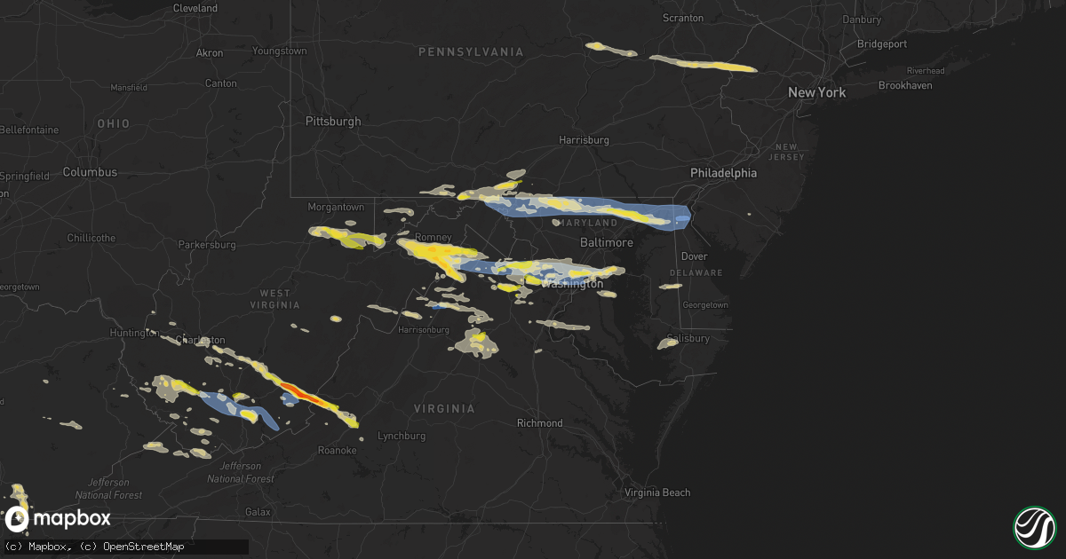
Hail Map on July 12, 2022
Get this storm
July 12 map
$229
one time, instant access
Download today. No call, no setup
Keep the $229
Bought the map and want the full workflow? Apply the entire $229 to a subscription within 7 days. None of it is wasted.
Every map, not just this one
This buys you this map. Subscription and you get every map we run, in the markets you choose from a few cities to whole states to nationwide. Plus real-time alerts the moment a storm fires.
Contact data
Name, contact info, occupancy, even credit band for addresses in the footprint. You go from where it hit to who to call.
Become the source they trust
Unlimited branding weather history reports on demand. You already have the documented answer ready for the property owner, and you are the one who showed up with it.
Property data and RoofTrace estimates
Pull up any address you have got, its value and the exact code rules for that jurisdiction, straight from One Click Code. Then RoofTrace estimates the squares, pitch, and roof value, priced the way you price.
States Impacted by Hail Map on July 12, 2022
Storm reports
New Hampshire
| Date | Description |
|---|---|
| 07/12/20225:07 PM CDT | Tree limb on wires. Time estimated by radar. |
| 07/12/20224:35 PM CDT | Tree and wires down. Time estimated by radar. |
| 07/12/20224:32 PM CDT | Reported by amateur radio. |
| 07/12/20224:30 PM CDT | Reported by weather spotter. |
| 07/12/20224:28 PM CDT | Delayed report...several trees down across roads in the milton area. |
| 07/12/20224:20 PM CDT | A tree and wires down. Time estimated by radar. |
| 07/12/20224:12 PM CDT | Multiple trees down... One on wires. Time estimated by radar. |
| 07/12/20224:12 PM CDT | Approximately 10 inch tree down on wires... Lower wires broken. |
| 07/12/20224:10 PM CDT | Tree down... Approximately 8 inch diameter. |
| 07/12/20224:02 PM CDT | Reported by weather spotter. |
| 07/12/20224:00 PM CDT | Reported by weather spotter. |
| 07/12/20223:55 PM CDT | Tree and wires down... Time estimated by radar. |
| 07/12/20223:43 PM CDT | Reported by amateur radio. |
| 07/12/20223:42 PM CDT | Delayed report...branches and trees down east of henniker. Time estimated by radar. |
| 07/12/20223:35 PM CDT | A local report indicates 1.25 inch wind near WALPOLE |
| 07/12/20223:30 PM CDT | Tree down. |
| 07/12/20223:24 PM CDT | Several branches and a few trees down on route 31 north of washington near pillsbury state park. |
| 07/12/20223:24 PM CDT | Wires and a couple poles down on the side of the road. Time estimated by radar. |
| 07/12/20223:24 PM CDT | Tree down on wires across road... Mayhew turnpike closed. |
| 07/12/20223:24 PM CDT | Tree and wires down... Sinclair road is closed. |
| 07/12/20223:20 PM CDT | Reported by weather spotter. |
| 07/12/20223:15 PM CDT | Wires... And a tree down. Time estimated by radar. |
| 07/12/20223:06 PM CDT | Wires down. Time estimated by radar. |
| 07/12/20223:06 PM CDT | Limbs and wires down. Time estimated by radar. |
| 07/12/20223:06 PM CDT | Reported by amateur radio: numerous branches and trees down on lovejoy rd and nh hwy 10 north of marlow junction. |
| 07/12/20223:05 PM CDT | Trees down... Local fire department on scene. Time estimated by radar. |
| 07/12/20223:04 PM CDT | Wire... Tree and pole down. Time estimated by radar. |
| 07/12/20223:04 PM CDT | Pole and wires down. Time estimated by radar. |
| 07/12/20223:00 PM CDT | Reported by weather spotter. |
| 07/12/20222:56 PM CDT | Numerous trees down in enfield center. |
| 07/12/20222:54 PM CDT | Reported by weather spotter hl590: several branches |
| 07/12/20222:52 PM CDT | Numerous branches down across meriden rd |
| 07/11/202211:55 PM CDT | At 454 PM EDT, a severe thunderstorm was located near Nelson, or 13 miles north of Jaffrey, moving east at 50 mph. HAZARD...60 mph wind gusts and quarter size hail. SOURCE...Radar indicated. IMPACT...Hail damage to vehicles is expected. Expect wind damage to roofs, siding, and trees. Locations impacted include... Manchester, Merrimack, Bedford, Milford, Amherst, Litchfield, Peterborough, New Boston, Antrim, Mont Vernon, Greenfield, Lyndeborough, Dublin, Francestown, Bennington, Harrisville, Windsor, Hancock, Goffstown and Deering.This includes the following highways... Interstate 293 between mile markers 1 and 9. Interstate 93 between mile markers 18 and 23. |
| 07/11/202211:24 PM CDT | At 422 PM EDT, severe thunderstorms were located along a line extending from Plymouth to near Hillsborough, moving east at 40 mph. HAZARD...60 mph wind gusts and quarter size hail. SOURCE...Trained weather spotters. These storms have a history of producing damaging winds. IMPACT...Hail damage to vehicles is expected. Expect wind damage to roofs, siding, and trees. Locations impacted include... Manchester, Concord, Laconia, Franklin, Henniker, New London, Moultonborough, Plymouth, Meredith, Ossipee, Grafton, Hooksett, Hopkinton, Loudon, Alton, Barnstead, Epsom, Gilmanton, Antrim and Canterbury.This includes the following highways... Interstate 293 between mile markers 9 and 11. Interstate 89 between mile markers 0 and 33. Interstate 93 between mile markers 26 and 83. |
| 07/11/202211:18 PM CDT | At 417 PM EDT, a severe thunderstorm was located 9 miles west of Walpole, or 17 miles northwest of Keene, moving east at 35 mph. HAZARD...60 mph wind gusts and quarter size hail. SOURCE...Radar indicated. IMPACT...Hail damage to vehicles is expected. Expect wind damage to roofs, siding, and trees. Locations impacted include... Keene, Peterborough, Antrim, Dublin, Harrisville, Nelson, Gilsum, Marlborough, Marlow, Roxbury, Walpole, Sullivan, Alstead, Westmoreland, Swanzey, Surry, Chesterfield, Hancock and Langdon. |
| 07/11/202210:46 PM CDT | At 345 PM EDT, a severe thunderstorm was located near Manchester Center, or near Manchester, moving east at 50 mph. HAZARD...60 mph wind gusts and quarter size hail. SOURCE...Radar indicated. IMPACT...Hail damage to vehicles is expected. Expect wind damage to roofs, siding, and trees. Locations impacted include... Bellows Falls, Londonderry, Townshend, Manchester, Saxtons River, Westminster, Manchester Center, Windham, Rockingham, Jamaica, Grafton, Brookline, Athens, Peru, North Westminster, Brockways Mills, South Windham, Barnumville, East Jamaica and Bartonsville. |
| 07/11/202210:28 PM CDT | At 328 PM EDT, a severe thunderstorm was located over Simonsville, moving east at 40 mph. HAZARD...60 mph wind gusts and quarter size hail. SOURCE...Radar indicated. IMPACT...Minor hail damage to vehicles is possible. Expect wind damage to trees and powerlines. Locations impacted include... Chester, Weston, Andover, Springfield, Baltimore, Mount Tabor, Weathersfield, Ludlow, Cavendish, Weathersfield Bow, West Springfield, North Chester, North Springfield, Simonsville and Gassetts. |
| 07/11/202210:26 PM CDT | At 326 PM EDT, a severe thunderstorm was located 9 miles south of West Pawlet, moving east at 45 mph. HAZARD...60 mph wind gusts and quarter size hail. SOURCE...Radar indicated. IMPACT...Minor hail damage to vehicles is possible. Expect wind damage to trees and powerlines. Locations impacted include... Chester, Baltimore, Weston, Andover, Springfield, Perkinsville Village, Weathersfield, Ascutney, Mount Tabor, Cavendish, Ludlow, Danby, Pawlet, Perkinsville, Weathersfield Bow, West Springfield, North Chester, North Springfield Lake Recreation Area, North Springfield and Simonsville. |
| 07/11/202210:14 PM CDT | At 314 PM EDT, a severe thunderstorm was located over South Sherburne, moving east at 50 mph. HAZARD...60 mph wind gusts and quarter size hail. SOURCE...Radar indicated. IMPACT...Minor hail damage to vehicles is possible. Expect wind damage to trees and powerlines. Locations impacted include... White River Junction, Woodstock, Hartland Four Corners, Woodstock Village, Windsor, Killington, Shrewsbury, Quechee, Pomfret, Plymouth, Hartland, Bridgewater, Mendon, Reading, West Windsor, Hartford, Barnard, Chittenden, Stockbridge and Clarendon. |
Alabama
| Date | Description |
|---|---|
| 07/12/202211:38 AM CDT | Social media report of a tree down on grimwood road. Time estimated by radar. |
| 07/12/20225:54 AM CDT | At 1053 PM CDT, severe thunderstorms were located along a line extending from Collinwood to Lynnville, moving southeast at 10 mph. HAZARD...60 mph wind gusts and quarter size hail. SOURCE...Radar indicated. IMPACT...Hail damage to vehicles is expected. Expect wind damage to roofs, siding, and trees. Locations impacted include... Lawrenceburg, Pulaski, Loretto, Collinwood, St. Joseph, Elkton, Minor Hill, Ethridge, Lynnville, Goodspring, Leoma, Westpoint, Frankewing and Iron City.This includes Interstate 65 between mile markers 7 and 21. |
| 07/11/202211:48 PM CDT | One power pole and nine power lines were knocked down by thunderstorm winds across north central and northwest madison county. Specific locations not available at this |
| 07/11/202211:48 PM CDT | Social media report/photo of a tree down on shadly lane circle blocking the street. |
| 07/11/202211:45 PM CDT | Multiple large tree limbs up to 12 inches in diameter were knocked down near the intersection of oakwood road and sparkman drive. Time estimated by radar. |
| 07/11/202211:43 PM CDT | Off of research park blvd nw and north of oakwood; 2 small trees fallen into one of the lanes and lane closed down. |
| 07/11/202211:28 PM CDT | A large tree limb and metal roofing peeled off of a home near the intersection of highway 53 and ready section road. Time estimated by radar. |
| 07/11/202211:05 PM CDT | Corrects previous tstm wnd dmg report from 5 se ardmore. A large tree limb and metal roofing peeled off of a home near the intersection of highway 53 and ready section |
Connecticut
| Date | Description |
|---|---|
| 07/12/20226:35 PM CDT | Tree and wires down at old stafford rd and curtis drive in tolland. Relayed by amateur radio. |
| 07/12/20226:35 PM CDT | Tree on power lines at slater rd in tolland... Ct. Relayed by amateur radio. |
| 07/12/20226:35 PM CDT | Tree down on wires on pilgrim drive. Confirmed by fd. Relayed by amateur radio. |
| 07/12/20226:25 PM CDT | Tree and wires down on holcomb terrace. Relayed by amateur radio. |
| 07/12/20225:14 PM CDT | Tree down blocking mathewson ave. Relayed via amateur radio. |
| 07/12/20224:35 PM CDT | Trees and wires blocking us-44. |
| 07/12/20224:34 PM CDT | Trees and wires down blocking road |
| 07/12/20223:14 AM CDT | At 814 PM EDT, a severe thunderstorm was located over Pomfret, or 13 miles northeast of Mansfield, moving east at 35 mph. HAZARD...60 mph wind gusts and quarter size hail. SOURCE...Radar indicated. IMPACT...Expect wind damage to trees and power lines. Minor hail damage to vehicles is possible. Locations impacted include... Killingly, Burrillville, Scituate, Glocester, Putnam, Thompson, Brooklyn, Woodstock, Foster, Pomfret, Hampton and Eastford. |
| 07/12/20222:08 AM CDT | At 708 PM EDT, a severe thunderstorm was located over Simsbury, or near Windsor, moving east at 35 mph. HAZARD...60 mph wind gusts and penny size hail. SOURCE...Radar indicated. IMPACT...Expect damage to trees and power lines. Locations impacted include... Manchester, Enfield, Vernon, Windsor, Mansfield, South Windsor, Simsbury, Bloomfield, Avon, Suffield, Ellington, Tolland, Windsor Locks, Coventry, Stafford, Somers, Granby, East Windsor, Willington and East Granby. |
| 07/12/20221:00 AM CDT | At 559 PM EDT, a severe thunderstorm was located over Chicopee, moving east at 45 mph. HAZARD...60 mph wind gusts and quarter size hail. This storm has a history of producing tree damage. SOURCE...Radar indicated. IMPACT...Expect wind damage to trees and power lines. Minor hail damage to vehicles is possible. Locations impacted include... Springfield, Chicopee, Holyoke, Agawam, West Springfield, Ludlow, South Hadley, Southbridge, Easthampton, Longmeadow, East Longmeadow, Belchertown, Wilbraham, Charlton, Palmer, Spencer, Dudley, Leicester, Ware and Sturbridge. |
| 07/12/202212:05 AM CDT | At 505 PM EDT, severe thunderstorms were located along a line extending from Hawley to near Millerton, moving east at 50 mph. HAZARD...60 mph wind gusts and quarter size hail. SOURCE...Radar indicated. IMPACT...Expect wind damage to trees and power lines. Minor hail damage to vehicles is possible. Locations impacted include... Springfield, Chicopee, Westfield, Holyoke, Amherst, Northampton, Agawam, West Springfield, Greenfield, Orange, Deerfield, Ludlow, South Hadley, Easthampton, Longmeadow, East Longmeadow, Belchertown, Wilbraham, Palmer and Ware. |
| 07/11/20227:25 PM CDT | Route 101 at upper maple street and route 101 at otis street - two trees down... One blocking half of the roadway. |
Wisconsin
| Date | Description |
|---|---|
| 07/12/20226:47 PM CDT | A local report indicates 62 MPH wind near GREEN BAY |
| 07/12/20222:44 AM CDT | At 743 PM CDT, a severe thunderstorm was located 10 miles northeast of Dorchester, or 10 miles east of Medford, moving southeast at 25 mph. HAZARD...60 mph wind gusts and penny size hail. SOURCE...Radar indicated. IMPACT...Expect damage to roofs, siding, and trees. This severe thunderstorm will remain over mainly rural areas of northwestern Marathon County, including the following locations... Edgar, Milan, Little Chicago, Marathon City, Hamburg, Poniatowski, Athens and Rib Falls. |
| 07/12/20221:35 AM CDT | At 635 PM CDT, a severe thunderstorm was located 9 miles south of Pulaski, or 10 miles west of Green Bay, moving southeast at 25 mph. HAZARD...60 mph wind gusts and quarter size hail. SOURCE...Radar indicated. IMPACT...Hail damage to vehicles is expected. Expect wind damage to roofs, siding, and trees. This severe thunderstorm will be near... Green Bay around 645 PM CDT. Bellevue Town around 655 PM CDT. |
Washington
| Date | Description |
|---|---|
| 07/12/20226:44 AM CDT | At 1144 PM PDT, a severe thunderstorm was located 17 miles west of Colfax, or 30 miles northwest of Pullman, moving northeast at 45 mph. HAZARD...Quarter size hail. SOURCE...Radar indicated. IMPACT...Damage to vehicles is expected. Locations impacted include... Rosalia, St. John, Oakesdale, Endicott, Malden, Thornton, Pine City, Winona, Ewen and Ewan. |
Vermont
| Date | Description |
|---|---|
| 07/12/20223:39 PM CDT | Picture of trees down from thunderstorm outflow. |
| 07/12/20223:31 PM CDT | Trees wires down in north hero and alburgh... Caused by thunderstorm outflow. |
| 07/12/20223:30 PM CDT | All lanes of i-91 sb closed north of exit 5 near mm29. Time estimated from radar. |
| 07/12/20222:52 PM CDT | Trees and powerlines down across springfield. Multiple power outages being reported by utlity companies. |
| 07/12/20222:52 PM CDT | Trees and powerlines down across springfield. Multiple power outages being reported by utlity ompanies. |
| 07/12/20222:45 PM CDT | Trees down in dana l. Thompson park. |
| 07/12/20222:45 PM CDT | Multiple trees down and pea sized hail near manchester. Time estimated from radar. |
| 07/12/20222:44 PM CDT | At least a dozen trees were knocked over by thunderstorm winds. Several power poles were snapped in half. |
| 07/12/20222:44 PM CDT | Tree and wires down on lower hollow road |
| 07/12/20222:40 PM CDT | Extensive utility damage in chester. Multiple power lines down... Power poles snapped... Tress on power lines and trees blocking roadways. |
| 07/12/20222:40 PM CDT | Extensive utility damage in chester. Multiple power lines down... Power poles snapped... Trees on power lines and trees blocking roadways. |
| 07/12/20222:36 PM CDT | Numerous trees down. |
| 07/12/20222:33 PM CDT | Numerous trees down |
| 07/12/20222:32 PM CDT | Several big tress down on powerlines. One by howe hill in pomfret and the other about a mile southeast of there. |
| 07/12/20222:32 PM CDT | Several big trees down on powerlines. One by howe hill in pomfret and the other about a mile southeast of there. |
| 07/12/20222:15 PM CDT | Trees down |
| 07/12/20222:08 PM CDT | 4 trees and large limbs down. |
| 07/12/20222:01 PM CDT | Trees on wires |
| 07/12/20221:58 PM CDT | 4 trees down on pittsford road |
| 07/12/20221:54 PM CDT | Trees and powerlines down in danby. |
| 07/12/20221:51 PM CDT | Tree and wires down on route 315 |
| 07/12/20221:40 PM CDT | Trees down on wires240 |
| 07/12/20221:29 PM CDT | Trees down on wires |
| 07/11/202210:32 PM CDT | At 331 PM EDT, severe thunderstorms were located along a line extending from 13 miles northwest of Hanover to 11 miles west of Charlestown, moving east at 40 mph. HAZARD...60 mph wind gusts and nickel size hail. SOURCE...Radar indicated. IMPACT...Expect damage to roofs, siding, and trees. Locations impacted include... Claremont, Lebanon, Henniker, New London, Plymouth, Grafton, Hanover, Charlestown, Enfield, Canaan, Holderness, Ashland, Bradford, Danbury, Groton, Newport, Warner, Marlow, Piermont and Alstead.This includes the following highways... Interstate 89 between mile markers 19 and 60. Interstate 93 between mile markers 78 and 93. |
| 07/11/202210:27 PM CDT | At 327 PM EDT, a severe thunderstorm was located over South Tunbridge, moving northeast at 60 mph. HAZARD...60 mph wind gusts and quarter size hail. SOURCE...Radar indicated. IMPACT...Minor hail damage to vehicles is possible. Expect wind damage to trees and powerlines. Locations impacted include... West Fairlee, Bradford, Tunbridge, Vershire, Sharon, Thetford Hill State Park, Thetford Center, Randolph, Strafford, Pomfret, Norwich, Thetford, Royalton, Fairlee, Bethel, Barnard, Hartford, Chelsea, Corinth and South Tunbridge. |
| 07/11/202210:07 PM CDT | At 305 PM EDT, severe thunderstorms were located near Wilton, New York and also in northern Bennington county, Vermont. Both were moving east at 40 mph. HAZARD...60 mph wind gusts and quarter size hail. SOURCE...Radar indicated. IMPACT...Hail damage to vehicles is expected. Expect wind damage to roofs, siding, and trees. Locations impacted include... Salem, Manchester, Dorset, Manchester Center, Northumberland, Rupert, Sandgate, Peru, Argyle, Cossayuna, Beartown, Jewell Corner, Goose Island, Peru Town Center, East Hebron, Tiplady, Barnumville, Gansevoort, Freedleyville and West Rupert. |
| 07/11/20229:42 PM CDT | At 241 PM EDT, a severe thunderstorm was located near Corinth, or 13 miles west of Glens Falls, moving east at 50 mph. Another severe storm is located within the warning area over eastern Washington County east of Hudson Falls, moving east at 50 mph. HAZARD...60 mph wind gusts and quarter size hail. SOURCE...Radar indicated. IMPACT...Hail damage to vehicles is expected. Expect wind damage to roofs, siding, and trees. Locations impacted include... Glens Falls, Hudson Falls, Fort Edward, Corinth, Granville, Hartford, Comstock, West Glens Falls, Lake Luzerne Campground, Glens Falls North, Poultney Village, Kings, Mount Pleasant, Queensbury, Wilton, Kingsbury, Porter, South Glens Falls, Lake Luzerne and Hadley. |
| 07/11/20229:27 PM CDT | At 226 PM EDT, severe thunderstorms were located along a line extending from near Huletts Landing to near Lake George Village to Northville, moving east at 50 mph. HAZARD...60 mph wind gusts and quarter size hail. SOURCE...Radar indicated. IMPACT...Hail damage to vehicles is expected. Expect wind damage to roofs, siding, and trees. Locations impacted include... Whitehall, Lake George Village, Comstock, Day Center, Bolton Landing, Lake Luzerne Campground, Poultney Village, Mount Hope, Bolton, Hadley, Hampton, Lake George, Fort Ann, Cleverdale, North Granville, South Bay Village, Snody Dock, Conklingville, Truthville and Hampton Flats and the Great Sacandaga Lake. |
| 07/11/20229:25 PM CDT | At 225 PM EDT, a severe thunderstorm was located over Benson Landing, moving east at 50 mph. HAZARD...60 mph wind gusts. SOURCE...Radar indicated. IMPACT...Expect damage to trees and powerlines. Locations impacted include... Rutland, Castleton, West Castleton, Sudbury, Hubbardton, Killington, Orwell, Stockbridge, Proctor, Benson, Brandon, Chittenden, Mendon, Pittsfield, Pittsford, West Haven, Fair Haven, West Rutland, Rutland City and Goshen. |
| 07/11/20229:14 PM CDT | At 214 PM EDT, a severe thunderstorm was located over Fort Edward, or over Hudson Falls, moving east at 55 mph. HAZARD...60 mph wind gusts and quarter size hail. SOURCE...Radar indicated. IMPACT...Hail damage to vehicles is expected. Expect wind damage to roofs, siding, and trees. Locations impacted include... Glens Falls, Hudson Falls, Fort Edward, Granville, Hartford, Comstock, Glens Falls North, West Glens Falls, Queensbury, Kingsbury, Porter, South Glens Falls, Rupert, Fort Ann, Argyle, Dunham Basin, Smiths Basin, Goose Island, Adamsville and North Granville. |
| 07/11/20229:13 PM CDT | At 213 PM EDT, a severe thunderstorm was located near Huletts Landing, or 9 miles northwest of Whitehall, moving east at 40 mph. HAZARD...60 mph wind gusts. SOURCE...Radar indicated. IMPACT...Expect damage to roofs, siding, and trees. Locations impacted include... Hague, Rogers Rock Campground, Huletts Landing, Putnam, Dresden Center, Putnam Station, Silver Bay, Snody Dock, Clemons, Sabbath Day Point, Indian Kettles, Hampton Flats, Graphite, Glenburnie and Ottenburgs Ramp. |
Louisiana
| Date | Description |
|---|---|
| 07/12/202212:53 AM CDT | At 553 PM CDT, a severe thunderstorm was located near Grand Chenier, moving west at 30 mph. HAZARD...60 mph wind gusts. SOURCE...Radar indicated. IMPACT...Expect damage to roofs, siding, and trees. Locations impacted include... Grand Chenier, Creole and Rutherford Beach. |
West Virginia
| Date | Description |
|---|---|
| 07/12/20226:49 PM CDT | Numerous trees down around augusta near route 50 and ford hill road. |
| 07/12/20226:09 PM CDT | One tree down on indian mills rd. Time estimated by radar. |
| 07/12/20226:06 PM CDT | One tree down on dry fork run. Time estimated by radar. |
| 07/12/20225:52 PM CDT | Pea to quarter sized hail. Time based on radar. |
| 07/12/20225:49 PM CDT | Two trees down on i-64 east. Location approximate. Time based on radar. |
| 07/12/20225:42 PM CDT | A local report indicates 1.25 inch wind near 2 WNW ELLISON |
| 07/12/20225:34 PM CDT | Trees and powerlines down on a truck along route 219 near the greenbrier county line. No injuries. |
| 07/12/20225:33 PM CDT | Thunderstorm winds blew many twigs down and also three to four limbs of wrist size diameter. Time estimated from radar. |
| 07/12/20225:32 PM CDT | Trees and powerlines down on midland trail east of lewisburg. |
| 07/12/20225:32 PM CDT | A local report indicates 1.75 inch wind near 2 NE LEWISBURG |
| 07/12/20225:30 PM CDT | A local report indicates 1.00 inch wind near 3 S MAXWELTON |
| 07/12/20225:28 PM CDT | High voltage power lines were blown down which shutdown i-64 for over an hour. Time estimated by radar. |
| 07/12/20225:27 PM CDT | Tree down on flat top rd. |
| 07/12/20225:23 PM CDT | Tree down at whitby rd and coal city rd. |
| 07/12/20225:21 PM CDT | Tree down 4000 block of odd rd. |
| 07/12/20225:21 PM CDT | Multiple trees down on coal city rd. |
| 07/12/20225:21 PM CDT | Tree down 800 block of shawnee ct. |
| 07/12/20225:18 PM CDT | Multiple trees down near alta. |
| 07/12/20225:15 PM CDT | Damage to roof and vehicles. |
| 07/12/20225:08 PM CDT | A local report indicates 1.00 inch wind near 2 NNW MABSCOTT |
| 07/12/20224:55 PM CDT | Tree down on poplar gap rd. Time estimated by radar. |
| 07/12/20224:55 PM CDT | Multiple trees down in fayetteville. |
| 07/12/20224:51 PM CDT | 2 trees down on rt. 85 in kopperston. |
| 07/12/20224:47 PM CDT | Multiple trees down in oak hill. |
| 07/12/20224:39 PM CDT | Tree and power lines down on perry branch rd in chapmanville. |
| 07/12/20224:39 PM CDT | A local report indicates 1.00 inch wind near 5 ENE MITCHELL HEIGHTS |
| 07/12/20224:28 PM CDT | Multiple trees down in montgomery. |
| 07/12/20224:21 PM CDT | Tree down at cabin creek rd and creek ln. |
| 07/12/20224:21 PM CDT | Tree down at cabin creek rd and wealthy acres rd. |
| 07/12/20224:10 PM CDT | Tree down at cabin creek rd and creek ln. Time is estimated by radar. |
| 07/12/20224:10 PM CDT | Tree down at cabin creek rd and wealthy acres rd. Time is estimated by radar. |
| 07/12/20224:05 PM CDT | Tree down at hannan trace rd and glenwood rd. |
| 07/12/20224:03 PM CDT | 2 trees down on maccorkle avenue in marmet. |
| 07/12/20223:52 PM CDT | 2 trees down on maccorkle avenue in marmet. Time is radar estimated. |
| 07/12/20223:48 PM CDT | Tree down on cane fork rd. |
| 07/12/20223:45 PM CDT | Numerous trees down including some on structures. |
| 07/12/20223:24 PM CDT | Tree down. |
| 07/12/20223:12 PM CDT | 2 trees down on hickory road. |
| 07/12/20223:12 PM CDT | 2 trees down in the area. |
| 07/12/20223:05 PM CDT | Tree down at hannan trace rd and glenwood rd. |
| 07/12/20223:02 PM CDT | Tree down. |
| 07/12/20223:00 PM CDT | A local report indicates 1.00 inch wind near 3 SSE WARDENSVILLE |
| 07/12/20222:59 PM CDT | A tree blew down near the 8800 block of back creek rd. |
| 07/12/20222:58 PM CDT | Multiple trees and large branches snapped. |
| 07/12/20222:57 PM CDT | Numerous trees down in wardensville. |
| 07/12/20222:55 PM CDT | Numerous trees down around capon springs. Trees on roadways shut down multiple roads in the area. |
| 07/12/20222:52 PM CDT | Numerous trees down around delray. Trees on roadways shut down multiple roads in the area. |
| 07/12/20222:52 PM CDT | Tree reported down on upper patterson creek road near seymoursville road. |
| 07/12/20222:50 PM CDT | A few trees down around the city of petersburg. |
| 07/12/20222:49 PM CDT | Downed trees damaging a tin shed. |
| 07/12/20222:49 PM CDT | Numerous trees down around augusta near route 50 and ford hill road. |
| 07/12/20222:47 PM CDT | A tree blew down near the 730 block of tanager trail. |
| 07/12/20222:47 PM CDT | Numerous trees down in rio. |
| 07/12/20222:46 PM CDT | Tree down along ford hill road. |
| 07/12/20222:43 PM CDT | A tree blew down near the 12500 block of grassy lick rd. |
| 07/12/20222:41 PM CDT | Tree reported down on the 4700 block of jordan run road. |
| 07/12/20222:41 PM CDT | Multiple trees down along hemlock dr and old popular dr |
| 07/12/20222:40 PM CDT | Tree down. |
| 07/12/20222:36 PM CDT | Tree down. Time is radar estimate. |
| 07/12/20222:34 PM CDT | Power line down. Possibly struck by lightning. |
| 07/12/20222:34 PM CDT | Tree down. |
| 07/12/20222:34 PM CDT | Local law enforcement reported a tree down on crooked creek rd. Time is estimated by radar. |
| 07/12/20222:28 PM CDT | Tree reported down on greenland gap road near upper patterson creek road. |
| 07/12/20222:26 PM CDT | Tree reported down knobley road near buck ridge lane. |
| 07/12/20222:24 PM CDT | A tree blew down near knobley rd and buck ridge ln. |
| 07/12/20222:22 PM CDT | Multiple trees down along greenland gap road. |
| 07/12/20222:20 PM CDT | Tree down in the 4100 block of laurel dale road. |
| 07/12/20222:20 PM CDT | A tree blew down near the 4100 block of laurel dale rd. |
| 07/12/20222:09 PM CDT | Tree and wires down in fort ashby. |
| 07/12/20222:05 PM CDT | Tree down at hannan trace rd and glenwood rd. |
| 07/12/20222:02 PM CDT | Multiple trees down in the area just west of mt. Storm. |
| 07/12/20221:54 PM CDT | A combination of large branches and down trees along state route 72 |
| 07/12/20221:52 PM CDT | Two trees down along state route 72 |
| 07/12/20221:51 PM CDT | Several large limbs and one tree down on shower bath road |
| 07/12/20221:50 PM CDT | Trees down in the area of dogwood flats... Including one down on a power line. |
| 07/12/20221:46 PM CDT | Tree down on webster pike. Time is radar estimate. |
| 07/12/20221:37 PM CDT | Tree down on w veterans memorial highway in rosemont. Time is radar estimate. |
| 07/12/20221:37 PM CDT | Tree down on iron town road in thornton. |
| 07/12/20221:32 PM CDT | Tree down on w veterans memorial highway in rosemont. |
| 07/12/20221:30 PM CDT | Report of trees down throughout the county... Including several in the area of the route 26 and 50. |
| 07/12/20221:20 PM CDT | Report of trees down throughout the county... Including bottom of and crossing route 7 near the cheat river. |
| 07/12/20221:18 PM CDT | Tree down knottsville road. |
| 07/12/20221:05 PM CDT | Tree down on beverly pike. |
| 07/12/20221:04 PM CDT | Tree down on laurel run road. |
| 07/12/20221:32 AM CDT | At 631 PM EDT, a severe thunderstorm was located near Flat Top, or 10 miles north of Camp Creek, moving east at 30 mph. HAZARD...70 mph wind gusts and quarter size hail. SOURCE...Radar indicated. IMPACT...Hail damage to vehicles is expected. Expect considerable tree damage. Wind damage is also likely to mobile homes, roofs, and outbuildings. Locations impacted include... Princeton... Narrows... Athens... Peterstown... Camp Creek... Pipestem... and Rich Creek. |
| 07/12/202212:59 AM CDT | At 558 PM EDT, a severe thunderstorm was located near Bald Knob, or 13 miles north of Pineville, moving east-southeast at 40 mph. HAZARD...60 mph wind gusts and nickel size hail. SOURCE...Radar indicated. IMPACT...Expect damage to roofs, siding, and trees. Locations impacted include... Beckley, Mullens, Mabscott, Oceana, Sophia, Crab Orchard, Dry Creek, Macarthur, Coal City, Shady Spring, Twin Falls State Park, Beaver, Daniels, Lester, Rhodell, Naoma, Bolt, Arnett, Kopperston and Glen Daniel.This includes the following highways... West Virginia Turnpike between mile markers 30 and 45. Interstate 64 in West Virginia between mile markers 120 and 126. |
| 07/12/202212:35 AM CDT | At 534 PM EDT, severe thunderstorms were located along a line extending from near Summersville to 7 miles northwest of Mount Hope, moving east-southeast at 50 mph. HAZARD...60 mph wind gusts and quarter size hail. SOURCE...Radar indicated. IMPACT...Hail damage to vehicles is expected. Expect wind damage to roofs, siding, and trees. Locations impacted include... Summersville, Fayetteville, Richwood, Babcock State Park, Oak Hill, Mount Hope, Meadow Bridge, Pax, Thurmond, Canvas, Nettie and Mount Nebo.This includes the following highways... West Virginia Turnpike between mile markers 54 and 59. Route 19 between mile markers 5 and 39. |
| 07/12/202212:31 AM CDT | At 531 PM EDT, a severe thunderstorm was located near Logan, moving east at 35 mph. HAZARD...60 mph wind gusts and half dollar size hail. SOURCE...Radar indicated. IMPACT...Hail damage to vehicles is expected. Expect wind damage to roofs, siding, and trees. Locations impacted include... Logan, Oceana, Man, Mallory, Amherstdale-Robinette, Wharton, Bald Knob, Mount Gay-Shamrock, Holden, West Logan, Mitchell Heights, Mount Gay, Cyclone, Naoma, Arnett, Kopperston, Stickney, Blair, Amherstdale-Robine and Sharples.This includes Route 119 between mile markers 43 and 45. |
| 07/12/202212:03 AM CDT | At 502 PM EDT, severe thunderstorms were located along a line extending from near Ansted to near Burnwell, moving southeast at 35 mph. HAZARD...60 mph wind gusts and penny size hail. SOURCE...Law enforcement. Many reports of downed trees and power lines have been reported with this line of storms. IMPACT...Expect damage to roofs, siding, and trees. Locations impacted include... Beckley, Fayetteville, Babcock State Park, Oak Hill, Montgomery, Mount Hope, Mabscott, Ansted, Smithers, Gauley Bridge, Pratt, Dry Creek, Macarthur, Bradley, Powellton, Hawks Nest State Park, Beaver, Piney View, Stanaford and Prosperity.This includes the following highways... West Virginia Turnpike between mile markers 37 and 39, and betweenmile markers 41 and 80. Interstate 64 in West Virginia between mile markers 120 and 129. |
| 07/11/202211:37 PM CDT | At 436 PM EDT, severe thunderstorms were located along a line extending from near Cedar Grove to 7 miles southwest of Marmet, moving east at 35 mph. HAZARD...60 mph wind gusts and penny size hail. SOURCE...Radar indicated. IMPACT...Expect damage to roofs, siding, and trees. Locations impacted include... Charleston, Fayetteville, Montgomery, Chesapeake, Marmet, Ansted, Belle, Cedar Grove, East Bank, Glasgow, Smithers, Gauley Bridge, Pratt, Powellton, Hawks Nest State Park, Coal Fork, Burnwell, Handley, Seth and Dawes.This includes the following highways... Interstate 77 in West Virginia between mile markers 96 and 98. West Virginia Turnpike between mile markers 61 and 95. |
| 07/11/202211:10 PM CDT | At 409 PM EDT, severe thunderstorms were located along a line extending from near Cross Lanes to near Hamlin, moving east at 30 mph. HAZARD...60 mph wind gusts and penny size hail. SOURCE...Radar indicated. IMPACT...Expect damage to roofs, siding, and trees. Locations impacted include... Charleston, Nitro, Jefferson, South Charleston, St. Albans, Dunbar, Sissonville, Chesapeake, Marmet, Belle, Poca, Cross Lanes, Pinch, Alum Creek, Glen, Institute, Tornado, Coal Fork, Elkview and Teays Valley.This includes the following highways... Interstate 79 between mile markers 1 and 10. Interstate 77 in West Virginia between mile markers 96 and 111. Interstate 64 in West Virginia between mile markers 44 and 57. West Virginia Turnpike between mile markers 87 and 95. |
| 07/11/202210:59 PM CDT | At 359 PM EDT, a severe thunderstorm was located near Wardensville, or 9 miles northwest of Woodstock, moving east at 55 mph. HAZARD...60 mph wind gusts and quarter size hail. SOURCE...Radar indicated. IMPACT...Damaging winds will cause some trees and large branches to fall. This could injure those outdoors, as well as damage homes and vehicles. Roadways may become blocked by downed trees. Localized power outages are possible. Unsecured light objects may become projectiles. Locations impacted include... Front Royal, Strasburg, Woodstock, Linden, Chester Gap, Maurertown, Toms Brook, Fort Valley, Arco, Seven Fountains, Dilbeck, Harmony, Alonzaville, Riverton, Karo, Glen Echo, Perry, Bentonville, Fishers Hill and Browntown. |
| 07/11/202210:46 PM CDT | At 346 PM EDT, severe thunderstorms were located along a line extending from Winfield to near Culloden, moving east at 30 mph. HAZARD...60 mph wind gusts. SOURCE...Radar indicated. IMPACT...Expect damage to roofs, siding, and trees. Locations impacted include... Charleston, Nitro, Winfield, Jefferson, South Charleston, St. Albans, Dunbar, Hurricane, Sissonville, Milton, Eleanor, Poca, Cross Lanes, Culloden, Alum Creek, Institute, Tornado, Amma, Teays Valley and Elkview.This includes the following highways... Interstate 79 between mile markers 1 and 26. Interstate 77 in West Virginia between mile markers 100 and 116. Interstate 64 in West Virginia between mile markers 29 and 57. |
| 07/11/202210:22 PM CDT | At 322 PM EDT, a severe thunderstorm was located near Claylick, or 12 miles west of Hagerstown, moving east at 40 mph. HAZARD...60 mph wind gusts and quarter size hail. SOURCE...Radar indicated. IMPACT...Damaging winds will cause some trees and large branches to fall. This could injure those outdoors, as well as damage homes and vehicles. Roadways may become blocked by downed trees. Localized power outages are possible. Unsecured light objects may become projectiles. Locations impacted include... Hagerstown, Thurmont, Municipal Stadium, Robinwood, Fountainhead-Orchard Hills, Smithsburg, Paramount-Long Meadow, Wilson-Conococheague, Williamsport, Mount Aetna, Mount Lena, San Mar, Long Meadow, Wolfsville, Saint James, Halfway, Maugansville, Cavetown, Funkstown and Falling Waters. |
| 07/11/202210:16 PM CDT | At 316 PM EDT, a severe thunderstorm was located near Eleanor, or near Winfield, moving east at 35 mph. HAZARD...60 mph wind gusts and nickel size hail. SOURCE...Radar indicated. IMPACT...Expect damage to roofs, siding, and trees. Locations impacted include... Charleston, Nitro, Winfield, Jefferson, South Charleston, St. Albans, Dunbar, Hurricane, Sissonville, Eleanor, Buffalo, Poca, Cross Lanes, Institute, Teays Valley, Bancroft, Liberty and Fraziers Bottom.This includes the following highways... Interstate 79 between mile markers 1 and 4. Interstate 77 in West Virginia between mile markers 98 and 119. Interstate 64 in West Virginia between mile markers 35 and 57. |
| 07/11/202210:00 PM CDT | At 300 PM EDT, a severe thunderstorm was located over Barnes Gap, or 11 miles west of Hancock, moving east at 40 mph. HAZARD...60 mph wind gusts and quarter size hail. SOURCE...Radar indicated. IMPACT...Damaging winds will cause some trees and large branches to fall. This could injure those outdoors, as well as damage homes and vehicles. Roadways may become blocked by downed trees. Localized power outages are possible. Unsecured light objects may become projectiles. Locations impacted include... Hancock, Berkeley Springs, Clear Spring, Pecktonville, Big Spring, Big Pool, Cherry Run, Spohrs Crossroads, Spruce Pine Hollow, Forest Park, Bellegrove, Sleepy Creek and Shady Grove. |
| 07/11/20229:28 PM CDT | At 228 PM EDT, a severe thunderstorm was located near Grafton, moving east at 35 mph. HAZARD...60 mph wind gusts and half dollar size hail. SOURCE...Radar indicated. IMPACT...Hail damage to vehicles is expected. Expect wind damage to roofs, siding, and trees. Locations impacted include... Grafton, Knottsville, Moatsville, Tygart Lake State Park, Thornton and Nestorville. |
| 07/11/20229:02 PM CDT | At 202 PM EDT, a severe thunderstorm was located near Shinnston, or 8 miles northeast of Clarksburg, moving east at 35 mph. HAZARD...60 mph wind gusts and quarter size hail. SOURCE...Radar indicated. IMPACT...Hail damage to vehicles is expected. Expect wind damage to roofs, siding, and trees. Locations impacted include... Clarksburg, Grafton, Bridgeport, Shinnston, Lumberport, Anmoore, Enterprise, Flemington, Moatsville, Rosemont, Knottsville, Meadland, Tygart Lake State Park, Thornton, McGee, Meadowbrook and Despard.This includes the following highways... Interstate 79 between mile markers 119 and 128. Route 50 in West Virginia between mile markers 77 and 79, andbetween mile markers 81 and 82. |
| 07/11/20228:52 PM CDT | At 152 PM EDT, severe thunderstorms were located along a line extending from near Mount Davis to near Brookhaven, moving east at 35 mph. HAZARD...60 mph wind gusts and quarter size hail. SOURCE...Radar indicated. IMPACT...Damaging winds will cause some trees and large branches to fall. This could injure those outdoors, as well as damage homes and vehicles. Roadways may become blocked by downed trees. Localized power outages are possible. Unsecured light objects may become projectiles. Locations impacted include... Oakland, Bittinger, Grantsville, Friendsville, Deer Park, Accident, Merrill, Hutton, Keysers Ridge, Jennings, Mineral Spring, Deep Creek Lake State Park, Swallow Falls State Park, McHenry, Selbysport, Big Run State Park, New Germany, Piney Grove and McComas Beach. |
District of Columbia
| Date | Description |
|---|---|
| 07/12/20224:55 PM CDT | Multiple trees down in washington dc... Some onto vehicles |
| 07/12/202212:56 AM CDT | At 556 PM EDT, severe thunderstorms were located along a line extending from Hillandale to Lake Ridge, moving east at 40 mph. HAZARD...60 mph wind gusts and quarter size hail. SOURCE...Radar indicated. IMPACT...Damaging winds will cause some trees and large branches to fall. This could injure those outdoors, as well as damage homes and vehicles. Roadways may become blocked by downed trees. Localized power outages are possible. Unsecured light objects may become projectiles. Locations impacted include... Waldorf, Bowie, Clinton, Fort Washington, Greenbelt, Forestville, Largo, Coral Hills, Mayo, Shady Side, Chesapeake Beach, Deale, Prince Frederick, Upper Marlboro, South River, Breezy Point, Fedex Field, Rhode River, Andrews Air Force Base and Landover. |
| 07/12/202212:38 AM CDT | At 537 PM EDT, severe thunderstorms were located along a line extending from near North Potomac to near Linton Hall, moving east at 30 mph. HAZARD...60 mph wind gusts and quarter size hail. SOURCE...Radar indicated. IMPACT...Damaging winds will cause some trees and large branches to fall. This could injure those outdoors, as well as damage homes and vehicles. Roadways may become blocked by downed trees. Localized power outages are possible. Unsecured light objects may become projectiles. Locations impacted include... Arlington, Alexandria, Centreville, Dale City, Rockville, Bethesda, Reston, Annandale, Springfield, College Park, Fort Washington, Greenbelt, Fairfax, Langley Park, Beltsville, Fort Hunt, Vienna, Groveton, Falls Church and Huntington. |
Michigan
| Date | Description |
|---|---|
| 07/12/20227:37 AM CDT | At 1237 AM EDT, a severe thunderstorm was located near Memphis, or near Richmond, moving east at 50 mph. HAZARD...60 mph wind gusts. SOURCE...Radar indicated. IMPACT...Expect damage to roofs, siding, and trees. This severe thunderstorm will be near... St. Clair around 1245 AM EDT. Port Huron and Marysville around 1250 AM EDT.Other locations impacted by this severe thunderstorm include FortGratiot, Adair, Columbus, Rattle Run, Goodells, Smiths Creek andWadhams. |
Virginia
| Date | Description |
|---|---|
| 07/12/20226:59 PM CDT | Tree down on lock haven drive. |
| 07/12/20226:59 PM CDT | Tree down on wipledale avenue. |
| 07/12/20226:59 PM CDT | Multiple trees down near ridgewood farms. Time estimated by radar. |
| 07/12/20226:59 PM CDT | Several trees down along orange road and radiant way. |
| 07/12/20226:55 PM CDT | Tree down near the intersection of 16th street and culpepper avenue. |
| 07/12/20226:55 PM CDT | Tree down on old catawba rd. |
| 07/12/20226:55 PM CDT | Few trees down along edgebrook rd. |
| 07/12/20226:53 PM CDT | Powerlines reported down. |
| 07/12/20226:53 PM CDT | Trees were down along holly corner road and country manor drive. |
| 07/12/20226:53 PM CDT | Corrects previous hail report from 1 nne buchanan. |
| 07/12/20226:51 PM CDT | Tree down on catawba valley drive. |
| 07/12/20226:51 PM CDT | Tree down on narrow passage rd. |
| 07/12/20226:49 PM CDT | Trees down around hartwood and meadows roads. |
| 07/12/20226:47 PM CDT | Tree down on davis run. |
| 07/12/20226:45 PM CDT | A local report indicates 67 MPH wind near 2 ESE OAKPARK |
| 07/12/20226:44 PM CDT | Tree on wires near fitzwater drive and morla lane. |
| 07/12/20226:41 PM CDT | Tree down on leffel lane. |
| 07/12/20226:41 PM CDT | Numerous trees down in sumerduck. |
| 07/12/20226:41 PM CDT | Summerduck road closed from snake castle road to rogers ford road due to downed powerlines. |
| 07/12/20226:39 PM CDT | Tree down near the intersection of ford road and rutherford drive. |
| 07/12/20226:37 PM CDT | Numerous trees were down in bealton. |
| 07/12/20226:35 PM CDT | A local report indicates 1.00 inch wind near 4 NNW OAKPARK |
| 07/12/20226:32 PM CDT | A local report indicates 1.00 inch wind near 3 ESE MADISON |
| 07/12/20226:31 PM CDT | Trees down along route 29 by bradford road. |
| 07/12/20226:31 PM CDT | Several trees down along thoroughfare road. |
| 07/12/20226:25 PM CDT | Trees were down along mount zion church road. |
| 07/12/20226:20 PM CDT | Pea to shooter marble size hail covering the ground. |
| 07/12/20225:57 PM CDT | One tree and limbs down. Time estimated by radar. |
| 07/12/20225:56 PM CDT | A local report indicates 1.75 inch wind near 4 E ALLEGHANY |
| 07/12/20225:53 PM CDT | A local report indicates 1.00 inch wind near 1 NNE BUCHANAN |
| 07/12/20225:43 PM CDT | Tree down in 1300 blk of big oak rd |
| 07/12/20225:41 PM CDT | Tree down 100 block of w page street. |
| 07/12/20225:21 PM CDT | Lines down near the intersection of frank lane road and bowbender lane. |
| 07/12/20225:09 PM CDT | Old mill road at black alder drive is closed due to tree down. |
| 07/12/20224:53 PM CDT | Tree down near the intersection of hayfield road and manchester boulevard. |
| 07/12/20224:48 PM CDT | Tree down at hayfield rd. And manchester blvd. |
| 07/12/20224:44 PM CDT | Tree down along hamburg road and us 211. |
| 07/12/20224:42 PM CDT | Tree down on west page street |
| 07/12/20224:36 PM CDT | Tree down along twin lakes drive near twin lakes court. |
| 07/12/20224:34 PM CDT | Tree down blocking roadway on piedmont ave. |
| 07/12/20224:33 PM CDT | A tree blew down near hamburg rd and us-211 w. |
| 07/12/20224:31 PM CDT | Several trees down at residence |
| 07/12/20224:29 PM CDT | Large tree down on an occupied vehicle. |
| 07/12/20224:29 PM CDT | A local report indicates 70 MPH wind near 1 WSW CENTREVILLE |
| 07/12/20224:29 PM CDT | Tree down along hamburg road. |
| 07/12/20224:29 PM CDT | Tree down near lawyers road and blue spruce road. |
| 07/12/20224:29 PM CDT | Tree down on skyline drive just before the intersection with us-211 |
| 07/12/20224:29 PM CDT | A local report indicates 1.25 inch wind near BROKEN HILL |
| 07/12/20224:28 PM CDT | A local report indicates 61 MPH wind near DULLES INTL AIRPORT |
| 07/12/20224:27 PM CDT | Several large tree limbs down |
| 07/12/20224:23 PM CDT | Tree down along route 50 near pleasant valley road. |
| 07/12/20224:23 PM CDT | Trees down |
| 07/12/20224:23 PM CDT | Trees down |
| 07/12/20224:18 PM CDT | Numerous branches down around claiborne parkway and waxpool road. |
| 07/12/20224:15 PM CDT | Riley road from oakmont drive to lakeview drive is closed due to downed powerlines. |
| 07/12/20224:12 PM CDT | Numerous trees down in the plains. |
| 07/12/20224:09 PM CDT | A local report indicates 1.00 inch wind near 1 SW LEESBURG |
| 07/12/20224:09 PM CDT | A local report indicates 62 MPH wind near LEESBURG EXEC ARPT |
| 07/12/20224:07 PM CDT | Tree reported down on bunker hill road near featherstone lane. |
| 07/12/20224:05 PM CDT | Tree down on route 651 near us-15. |
| 07/12/20224:01 PM CDT | A local report indicates 1.00 inch wind near MARSHALL |
| 07/12/20224:01 PM CDT | A local report indicates 1.25 inch wind near MARSHALL |
| 07/12/20223:30 PM CDT | Tree down in 600 blk of white post rd |
| 07/12/20223:25 PM CDT | Tree down near intersection of old winchester and page brook ln |
| 07/12/20223:25 PM CDT | Tree down in 5300 blk of senseny rd |
| 07/12/20223:24 PM CDT | Quarter sized hail and 8 inch tree limbs down. |
| 07/12/20223:24 PM CDT | Multiple trees reported down on funk road southeast of strasburg. |
| 07/12/20223:22 PM CDT | Tree down in the 3100 block of river view dr. |
| 07/12/20223:22 PM CDT | Multiple trees down on funk road. Mobile camper heavily damaged with sides blown off. |
| 07/12/20223:16 PM CDT | A local report indicates 63 MPH wind near 2 NW CLARY |
| 07/12/20223:15 PM CDT | Tree down on battlefield rd. |
| 07/12/20223:15 PM CDT | Tree down at the intersection of capon dr. And john marshall way. |
| 07/12/20223:14 PM CDT | A local report indicates 58 MPH wind near 3 NNW STEPHENS CITY |
| 07/12/20224:48 AM CDT | At 948 PM EDT, a severe thunderstorm was located 7 miles east of Orange, moving east at 35 mph. HAZARD...60 mph wind gusts and quarter size hail. SOURCE...Radar indicated. IMPACT...Damaging winds will cause some trees and large branches to fall. This could injure those outdoors, as well as damage homes and vehicles. Roadways may become blocked by downed trees. Localized power outages are possible. Unsecured light objects may become projectiles. Locations impacted include... Orange, Spotsylvania, Ruckersville, Mine Run, Quinque, Eheart, Everona, Verdiersville, Montpelier Station, Locust Grove, Flat Run, Newtown, Nasons, Madison Mills, Montford, Old Somerset, Dunavant, Lake Of The Woods, Unionville and Cookstown. |
| 07/12/20223:43 AM CDT | At 843 PM EDT, severe thunderstorms were located along a line extending from near Madison to near Free Union, moving east at 30 mph. HAZARD...60 mph wind gusts and quarter size hail. SOURCE...Radar indicated. IMPACT...Damaging winds will cause some trees and large branches to fall. This could injure those outdoors, as well as damage homes and vehicles. Roadways may become blocked by downed trees. Localized power outages are possible. Unsecured light objects may become projectiles. Locations impacted include... Orange, Madison, Stanardsville, Ruckersville, Brightwood, Quinque, Eheart, Oakpark, Haneytown, Newtown, Madison Mills, Montford, Old Somerset, Amicus, Somerset, Shady Grove, Hood, Locust Dale, Rapidan and Pratts. |
| 07/12/20223:29 AM CDT | At 829 PM EDT, a severe thunderstorm was located near La Plata, moving east at 45 mph. HAZARD...60 mph wind gusts and quarter size hail. SOURCE...Radar indicated. IMPACT...Damaging winds will cause some trees and large branches to fall. This could injure those outdoors, as well as damage homes and vehicles. Roadways may become blocked by downed trees. Localized power outages are possible. Unsecured light objects may become projectiles. Locations impacted include... Waldorf, Chesapeake Ranch Estates, La Plata, Leonardtown, Prince Frederick, Popes Creek, Greenwell State Park, Hallowing Point, Saint Leonard Creek, Wicomico River, White Point Beach, Cuckold Creek, Sheridan Point, Calvert Cliffs, Saint Clements Bay, Port Tobacco River, Flag Harbor, California, Golden Beach and Lusby. |
| 07/12/20223:21 AM CDT | At 821 PM EDT, severe thunderstorms were located along a line extending from Stewartsville to near Pilot, moving southeast at 25 mph. HAZARD...60 mph wind gusts and quarter size hail. SOURCE...Radar indicated. IMPACT...Hail damage to vehicles is expected. Expect wind damage to roofs, siding, and trees. Locations impacted include... Rocky Mount... Floyd... Boones Mill... Copper Hill... Ferrum... Penhook... and Indian Valley. |
| 07/12/20223:06 AM CDT | At 806 PM EDT, a severe thunderstorm was located near Quantico, moving southeast at 40 mph. HAZARD...60 mph wind gusts and quarter size hail. SOURCE...Radar indicated. IMPACT...Damaging winds will cause some trees and large branches to fall. This could injure those outdoors, as well as damage homes and vehicles. Roadways may become blocked by downed trees. Localized power outages are possible. Unsecured light objects may become projectiles. Locations impacted include... Waldorf, La Plata, Port Tobacco River, Popes Creek, Saint Charles, Wicomico, Bryans Road, Hughesville, Potomac Heights, Bryantown, Pomfret, Port Tobacco Village, Marbury, Dentsville, Port Tobacco, Ironsides, Ripley, Rison, Bel Alton and Newburg. |
| 07/12/20222:58 AM CDT | At 756 PM EDT, severe thunderstorms were located along a line extending from Natural Bridge to near Lithia, moving east at 25 mph. HAZARD...Ping pong ball size hail and 60 mph wind gusts. SOURCE...Radar indicated. At 7:54Pm power lines were reported down near Buchanan. IMPACT...People and animals outdoors will be injured. Expect hail damage to roofs, siding, windows, and vehicles. Expect wind damage to roofs, siding, and trees. Locations impacted include... Lynchburg... Bedford... Altavista... Amherst... Buchanan... Glasgow... and Brookneal. |
| 07/12/20222:56 AM CDT | At 756 PM EDT, severe thunderstorms were located along a line extending from 7 miles north of Orange to near Stanardsville, moving east at 25 mph. HAZARD...60 mph wind gusts and quarter size hail. SOURCE...Radar indicated. IMPACT...Damaging winds will cause some trees and large branches to fall. This could injure those outdoors, as well as damage homes and vehicles. Roadways may become blocked by downed trees. Localized power outages are possible. Unsecured light objects may become projectiles. Locations impacted include... Orange, Spotsylvania, Gordonsville, Ruckersville, Mine Run, Quinque, Eheart, Oakpark, Barboursville, Everona, Verdiersville, Montpelier Station, Newtown, Thornhill, Nasons, Madison Mills, Montford, Mitchells, Old Somerset and Unionville. |
| 07/12/20222:29 AM CDT | At 729 PM EDT, severe thunderstorms were located along a line extending from Eagle Rock to Oakvale, moving southeast at 20 mph. HAZARD...60 mph wind gusts and quarter size hail. SOURCE...Radar indicated. IMPACT...Hail damage to vehicles is expected. Expect wind damage to roofs, siding, and trees. Locations impacted include... Roanoke... Blacksburg... Salem... Christiansburg... Radford... Pulaski... and Vinton. |
| 07/12/20222:12 AM CDT | At 712 PM EDT, severe thunderstorms were located along a line extending from near Bealeton to 6 miles west of Madison, moving southeast at 40 mph. HAZARD...60 mph wind gusts and quarter size hail. SOURCE...Radar indicated. IMPACT...Damaging winds will cause some trees and large branches to fall. This could injure those outdoors, as well as damage homes and vehicles. Roadways may become blocked by downed trees. Localized power outages are possible. Unsecured light objects may become projectiles. Locations impacted include... Culpeper, Orange, Madison, Bealeton, Stanardsville, Big Meadows, Brightwood, Opal, Remington, Midland, Brandy Station, Oakpark, Verdiersville, Haywood, Montpelier Station, Syria, Winston, Heflin, Madison Mills and Montford. |
| 07/12/20221:53 AM CDT | At 653 PM EDT, a severe thunderstorm was located near Sperryville, or 18 miles north of Madison, moving east at 40 mph. HAZARD...60 mph wind gusts and quarter size hail. SOURCE...Radar indicated. IMPACT...Damaging winds will cause some trees and large branches to fall. This could injure those outdoors, as well as damage homes and vehicles. Roadways may become blocked by downed trees. Localized power outages are possible. Unsecured light objects may become projectiles. Locations impacted include... Sperryville, Washington, Castleton, Five Forks, Panorama, Rock Mills, Viewtown, Woodville, Hackleys Crossroads and Amissville. |
| 07/12/20221:43 AM CDT | At 643 PM EDT, a severe thunderstorm was located near Broadway, or 11 miles northeast of Harrisonburg, moving east at 30 mph. HAZARD...60 mph wind gusts and quarter size hail. SOURCE...Radar indicated. IMPACT...Damaging winds will cause some trees and large branches to fall. This could injure those outdoors, as well as damage homes and vehicles. Roadways may become blocked by downed trees. Localized power outages are possible. Unsecured light objects may become projectiles. Locations impacted include... Shenandoah, Stanley, Big Meadows, New Market, Alma, Newport, Honeyville, Ingham, Leaksville, Ida, Pine Grove and Jollett. |
| 07/12/20221:42 AM CDT | At 640 PM EDT, a severe thunderstorm was located over White Sulphur Springs, moving east at 35 mph. HAZARD...Ping pong ball size hail and 60 mph wind gusts. SOURCE...Radar indicated. At 6:38 PM downed trees and power lines were reported east of Lewisburg. IMPACT...People and animals outdoors will be injured. Expect hail damage to roofs, siding, windows, and vehicles. Expect wind damage to roofs, siding, and trees. Locations impacted include... Alleghany... Covington... Clifton Forge... Lewisburg... Hinton... White Sulphur Springs... and Ronceverte. |
| 07/12/20221:22 AM CDT | At 622 PM EDT, a cluster of severe thunderstorms was centered over Mount Jackson, or 13 miles southwest of Woodstock, moving east at 30 mph. HAZARD...60 mph wind gusts and quarter size hail. SOURCE...Radar indicated. IMPACT...Damaging winds will cause some trees and large branches to fall. This could injure those outdoors, as well as damage homes and vehicles. Roadways may become blocked by downed trees. Localized power outages are possible. Unsecured light objects may become projectiles. Locations impacted include... Luray, Timberville, Mount Jackson, New Market, Kimball, Kings Crossing, Compton, Shenandoah Caverns, Hamburg, Quicksburg, Fairview, Saint Davids Church, Hawkinstown, Panorama, Forestville, Mount Clifton and Rileyville. |
| 07/12/20221:17 AM CDT | At 617 PM EDT, a severe thunderstorm was located 8 miles southeast of Sperryville, or 10 miles northwest of Culpeper, moving east at 25 mph. HAZARD...60 mph wind gusts and quarter size hail. SOURCE...Radar indicated. IMPACT...Damaging winds will cause some trees and large branches to fall. This could injure those outdoors, as well as damage homes and vehicles. Roadways may become blocked by downed trees. Localized power outages are possible. Unsecured light objects may become projectiles. Locations impacted include... Warrenton, Bealeton, Opal, Castleton, Turnbull, Viewtown, Rixeyville, Amissville, Jeffersonton, Alanthus and Boston. |
| 07/12/20221:08 AM CDT | At 608 PM EDT, a severe thunderstorm was located 10 miles east of Brandywine, or 14 miles northwest of Harrisonburg, moving east at 35 mph. HAZARD...60 mph wind gusts and quarter size hail. SOURCE...Radar indicated. IMPACT...Damaging winds will cause some trees and large branches to fall. This could injure those outdoors, as well as damage homes and vehicles. Roadways may become blocked by downed trees. Localized power outages are possible. Unsecured light objects may become projectiles. Locations impacted include... Harrisonburg, Broadway, Timberville, Cherry Grove, Lacey Spring, Fulks Run, Singers Glen, Rawley Springs, Linville and Sparkling Springs. |
| 07/12/202212:29 AM CDT | At 529 PM EDT, a severe thunderstorm was located near Franklin, moving east at 30 mph. HAZARD...60 mph wind gusts and quarter size hail. SOURCE...Radar indicated. IMPACT...Damaging winds will cause some trees and large branches to fall. This could injure those outdoors, as well as damage homes and vehicles. Roadways may become blocked by downed trees. Localized power outages are possible. Unsecured light objects may become projectiles. Locations impacted include... Franklin, Brandywine, Upper Tract, Brushy Run, Yankeetown, Riverton, Deer Run, Circleville, Bergton, Ruddle, Seneca Rocks, Milam, Oak Flat, Brake and Criders. |
| 07/12/202212:20 AM CDT | At 520 PM EDT, a severe thunderstorm was located near Ansted, or 10 miles northeast of Fayetteville, moving east at 30 mph. HAZARD...60 mph wind gusts and quarter size hail. SOURCE...Radar indicated. IMPACT...Hail damage to vehicles is expected. Expect wind damage to roofs, siding, and trees. Locations impacted include... Lewisburg... Hinton... White Sulphur Springs... Ronceverte... Rainelle... Alderson... and Rupert. |
| 07/12/202212:16 AM CDT | At 516 PM EDT, a severe thunderstorm was located near Luray, or 10 miles southeast of Woodstock, moving east at 45 mph. HAZARD...60 mph wind gusts and quarter size hail. SOURCE...Radar indicated. IMPACT...Damaging winds will cause some trees and large branches to fall. This could injure those outdoors, as well as damage homes and vehicles. Roadways may become blocked by downed trees. Localized power outages are possible. Unsecured light objects may become projectiles. Locations impacted include... Warrenton, Sperryville, Hume, Marshall, Chester Gap, Opal, Flint Hill, Washington, Huntly, Kings Crossing, Hackleys Crossroads, Amissville, Jeffersonton, Cresthill, Turnbull, Saint Davids Church, Glen Echo, Bentonville, Meadowville and Rock Mills. |
| 07/11/202211:40 PM CDT | At 440 PM EDT, a severe thunderstorm was located near Woodstock, moving east at 40 mph. HAZARD...60 mph wind gusts and quarter size hail. SOURCE...Radar indicated. IMPACT...Damaging winds will cause some trees and large branches to fall. This could injure those outdoors, as well as damage homes and vehicles. Roadways may become blocked by downed trees. Localized power outages are possible. Unsecured light objects may become projectiles. Locations impacted include... Front Royal, Woodstock, Edinburg, Maurertown, Fort Valley, Seven Fountains, Dilbeck, Harmony, Riverton, Karo, Saint Davids Church, Glen Echo, Bentonville, Browntown and Riverside. |
| 07/11/202211:03 PM CDT | Trees knocked down across northern and central parts of the county. Time estimated from radar. |
| 07/11/202210:54 PM CDT | At 352 PM EDT, a severe thunderstorm was located near Wardensville, or 15 miles southeast of Romney, moving east at 55 mph. THIS IS A DESTRUCTIVE STORM FOR PORTIONS OF FREDERICK COUNTY, SHENANDOAH COUNTY, WARREN COUNTY, AND CLARKE COUNTY IN VA INCLUDING THE CITY OF WINCHESTER. HAZARD...80 mph wind gusts and tennis ball size hail. SOURCE...Radar indicated. IMPACT...Expect considerable damage to trees and power lines. Your life is at significant risk if outdoors. In addition to some trees falling into homes, wind damage is possible to roofs, sheds, open garages, and mobile homes. Locations impacted include... Winchester, Strasburg, Millwood Pike, Berryville, Stephens City, Wardensville, Star Tannery, Middletown, Boyce, Yellow Spring, High View, White Post, Gaylord, Blue Mountain, Nineveh, Albin, Bethel, Clary, Capon Springs and Stringtown. |
| 07/11/202210:36 PM CDT | At 335 PM EDT, a severe thunderstorm was located 9 miles northeast of Moorefield, moving east at 50 mph. THIS IS A DESTRUCTIVE STORM FOR NORTHERN HARDY AND SOUTHERN HAMPSHIRE COUNTY WV. HAZARD...80 mph wind gusts and two inch hail. SOURCE...Radar indicated. IMPACT...Expect considerable damage to trees and power lines. Your life is at significant risk if outdoors. In addition to some trees falling into homes, wind damage is possible to roofs, sheds, open garages, and mobile homes. Locations impacted include... Moorefield, Wardensville, Burlington, Russelldale, Augusta, Bean Settlement, Old Fields, Yellow Spring, Purgitsville, Mcneill, Delray, Inkerman, Kirby, Rio, Junction, Capon Springs, High View and Lehew. |
| 07/11/20228:49 PM CDT | Tree down on scuffletown road. |
| 07/11/20228:41 PM CDT | Tree down on owl road. Time based on radar. |
| 07/11/20227:59 PM CDT | Tree down on early drive in madison heights... Va. Time based on radar. |
| 07/11/20227:53 PM CDT | Numerous trees down near pratts. |
| 07/11/20227:35 PM CDT | Multiple trees down along route 20. |
| 07/11/20227:35 PM CDT | Multiple trees down along route 20. |
| 07/11/20227:26 PM CDT | Multiple trees down and powerline snapped near the intersection of winterhill drive and edwardsville rd. |
| 07/11/20227:23 PM CDT | Tree down on yellow mountain rd. |
| 07/11/20227:22 PM CDT | Dozens of trees and wires down on tower road. |
| 07/11/20227:19 PM CDT | A local report indicates 62 MPH wind near ORANGE COUNTY ARPT |
| 07/11/20227:10 PM CDT | A local report indicates 59 MPH wind near QUANTICO MARINE CORP |
| 07/11/20227:07 PM CDT | Tree down on wendover rd. |
| 07/11/20227:07 PM CDT | Tree down on grandin rd. |
| 07/11/20227:07 PM CDT | Tree down on darby rd. |
| 07/11/20227:05 PM CDT | A local report indicates 60 MPH wind near 1 S BLUE RIDGE |
| 07/11/20227:05 PM CDT | Corrects previous tstm wnd gst report from 1 s blue ridge. |
| 07/11/20227:03 PM CDT | Tree down along decatur road. |
| 07/11/20227:03 PM CDT | Trees were down around the intersection of decatur road and widewater road. |
| 07/11/20227:01 PM CDT | Tree down on woodlawn rd. |
| 07/11/20227:01 PM CDT | Trees were down along telegraph road and midway road. |
| 07/11/20227:00 PM CDT | 4 trees reported down near the intersection of lee highway and arcadia road. |
Kentucky
| Date | Description |
|---|---|
| 07/12/20225:42 PM CDT | Pictures on social media show a large portion of a yard pine tree snapped off along west chester avenue in middlesboro. |
| 07/12/20225:42 PM CDT | Pictures on social media show a large tree blown across dorchester avenue near the west end school. Another large tree was snapped and leaning on power lines. |
| 07/12/20225:37 PM CDT | Pictures posted by wril show multiple trees and branches had fallen onto a home along 43rd street... Leading to extensive roof interior ceiling damage. |
| 07/12/20225:29 PM CDT | Tree blown down along little clear creek road near ky route 190. |
| 07/12/20225:22 PM CDT | Tree blown down at 403 w. Tennessee ave. |
| 07/12/20225:22 PM CDT | Tree blown down at 110 east park avenue. |
| 07/12/20225:22 PM CDT | Tree blown down along ky route 190 about 6 miles from u.s. Route 25e. |
| 07/12/20225:19 PM CDT | 911 call center reports that a tree was down on east appletree rd about .4 miles from the intersection with ky-1651. Time estimated from radar. |
| 07/12/20225:10 PM CDT | 911 call center reports that a tree was down near the intersection of ky-1651 and old us 27. Time estimated from radar. |
| 07/12/20225:10 PM CDT | 911 call center reports that a tree was down near mile marker 7 on ky-700. Time estimated from radar. |
| 07/12/20225:10 PM CDT | 911 call center reports that a tree was down near mile marker4 on ky-90. Time estimated from radar. |
| 07/12/20225:10 PM CDT | 911 call center reports that a tree was down near pine knot middle school near the intersection of ky-2792 and us 27. Time estimated from radar. |
| 07/12/20225:00 PM CDT | Trained spotter reports numerous trees down on property. |
| 07/12/20224:25 PM CDT | Reports of several trees down. Time estimated by radar. |
| 07/12/20223:59 PM CDT | Reports of several trees and powerlines down. Time estimated by radar. |
| 07/12/20223:30 PM CDT | Trees being removed from b. Bertram road. |
| 07/12/20223:28 PM CDT | Several trees down on power lines. |
| 07/12/20223:25 PM CDT | Public report relayed by wbko. Downed trees on a property along dripping springs church road near wisdom. |
| 07/12/20222:14 AM CDT | At 713 PM EDT, a severe thunderstorm was located near Helenwood, or near Oneida, moving east at 20 mph. HAZARD...60 mph wind gusts and nickel size hail. SOURCE...Radar indicated. IMPACT...Expect damage to roofs, siding, and trees. Locations impacted include... Oneida, Huntsville, Helenwood, Winfield, Ketchen, Honey Creek State Park, Norma, Elgin, Robbins and Slick Rock. |
| 07/12/20221:41 AM CDT | At 639 PM EDT, a severe thunderstorm was located near Harrogate, or 9 miles east of Middlesboro, moving southeast at 25 mph. HAZARD...60 mph wind gusts and quarter size hail. SOURCE...Radar indicated. IMPACT...Hail damage to vehicles is expected. Expect wind damage to roofs, siding, and trees. Locations impacted include... New Tazewell, Tazewell, Harrogate, Howard Quarter, Cumberland Gap, Ewing, Arthur, Powell River Preserve and Rose Hill. |
| 07/12/20221:16 AM CDT | At 615 PM EDT, a severe thunderstorm was located over Stearns, or over Whitley City, moving southeast at 20 mph. HAZARD...60 mph wind gusts and penny size hail. SOURCE...Radar indicated. IMPACT...Expect damage to roofs, siding, and trees. Locations impacted include... La Follette, Oneida, Jellico, Winfield, Elk Valley, Ketchen, Indian Mountain State Park, Clairfield, Fincastle and White Oak.This includes Interstate 75 in Tennessee between mile markers 143 and161. |
| 07/12/20221:11 AM CDT | At 611 PM EDT, a severe thunderstorm was located near Whitley City, moving east at 25 mph. HAZARD...60 mph wind gusts and quarter size hail. SOURCE...Radar indicated. IMPACT...Hail damage to vehicles is expected. Expect wind damage to roofs, siding, and trees. This severe thunderstorm will be near... Duckrun around 625 PM EDT. Bounty around 630 PM EDT.Other locations in the path of this severe thunderstorm includeJellico Creek, Bon and Emlyn. |
| 07/12/202212:17 AM CDT | At 516 PM EDT, a severe thunderstorm was located near Steubenville, or near Monticello, moving east at 25 mph. HAZARD...60 mph wind gusts and quarter size hail. SOURCE...Radar indicated. IMPACT...Hail damage to vehicles is expected. Expect wind damage to roofs, siding, and trees. This severe thunderstorm will be near... Monticello around 525 PM EDT. Steubenville around 530 PM EDT. Betsey around 535 PM EDT.Other locations in the path of this severe thunderstorm includeGregory, Delta and Denney. |
| 07/12/202212:11 AM CDT | At 511 PM EDT, a severe thunderstorm was located over Decoy, or 13 miles east of Jackson, moving east at 25 mph. HAZARD...60 mph wind gusts and quarter size hail. SOURCE...Radar indicated. IMPACT...Hail damage to vehicles is expected. Expect wind damage to roofs, siding, and trees. This severe thunderstorm will be near... Decoy around 515 PM EDT. Buck around 520 PM EDT. Elmrock around 530 PM EDT.Other locations in the path of this severe thunderstorm includeYellow Mountain, Handshoe and Bolyn. |
| 07/12/202212:06 AM CDT | At 506 PM EDT, a severe thunderstorm was located over Grade, or 8 miles southeast of Somerset, moving southeast at 30 mph. HAZARD...60 mph wind gusts and half dollar size hail. SOURCE...Radar indicated. IMPACT...Hail damage to vehicles is expected. Expect wind damage to roofs, siding, and trees. This severe thunderstorm will be near... Mount Victory around 515 PM EDT. Huxley around 525 PM EDT.Other locations in the path of this severe thunderstorm include BarkCamp, Grove and Youngs Creek. |
| 07/11/202211:43 PM CDT | At 443 PM EDT, a severe thunderstorm was located over Quicksand, or over Jackson, moving east at 25 mph. HAZARD...60 mph wind gusts and quarter size hail. SOURCE...Radar indicated. IMPACT...Hail damage to vehicles is expected. Expect wind damage to roofs, siding, and trees. This severe thunderstorm will be near... Wilstacy around 450 PM EDT. Sikes around 455 PM EDT.Other locations in the path of this severe thunderstorm includeNoble, Daisydell and Buck. |
| 07/11/202211:39 PM CDT | At 438 PM EDT, a severe thunderstorm was located over Shopville, or near Somerset, moving east at 35 mph. HAZARD...60 mph wind gusts and quarter size hail. SOURCE...Radar indicated. IMPACT...Hail damage to vehicles is expected. Expect wind damage to roofs, siding, and trees. This severe thunderstorm will be near... Dykes around 445 PM EDT. |
| 07/11/202211:28 PM CDT | At 428 PM EDT, a severe thunderstorm was located over Mariba, or near Frenchburg, moving east at 30 mph. HAZARD...60 mph wind gusts and quarter size hail. SOURCE...Radar indicated. IMPACT...Hail damage to vehicles is expected. Expect wind damage to roofs, siding, and trees. This severe thunderstorm will be near... Wellington around 435 PM EDT. Artville around 440 PM EDT. Omer around 445 PM EDT.Other locations in the path of this severe thunderstorm includeHenry, Licking River and West Liberty. |
| 07/11/202211:19 PM CDT | At 419 PM EDT, a severe thunderstorm was located near Magnum, or 10 miles southeast of Liberty, moving east at 25 mph. HAZARD...60 mph wind gusts and quarter size hail. SOURCE...Radar indicated. IMPACT...Hail damage to vehicles is expected. Expect wind damage to roofs, siding, and trees. This severe thunderstorm will be near... Hogue around 430 PM EDT.Other locations in the path of this severe thunderstorm includeScience Hill and Dabney. |
| 07/11/202210:56 PM CDT | At 356 PM CDT, a severe thunderstorm was located near Portland, or 13 miles northwest of Gallatin, moving southeast at 15 mph. HAZARD...60 mph wind gusts and nickel size hail. SOURCE...Radar indicated. IMPACT...Expect damage to roofs, siding, and trees. Locations impacted include... Gallatin, Westmoreland, Cross Plains, Portland, Mitchellville, Cottontown, Oak Grove and Black Jack. |
| 07/11/202210:48 PM CDT | At 347 PM EDT/247 PM CDT/, a severe thunderstorm was located 7 miles south of Campbellsville, moving east at 30 mph. HAZARD...60 mph wind gusts and nickel size hail. SOURCE...Radar indicated. IMPACT...Expect damage to roofs, siding, and trees. This severe thunderstorm will remain over mainly rural areas of south central Taylor and northeastern Adair Counties, including the following locations... Casey Creek, Knifley, Yuma, Burdick, Atchison, Neatsville, Romine, Purdy, Ella and Holmes. |
| 07/11/202210:48 PM CDT | At 348 PM CDT, a severe thunderstorm was located near Jamestown, moving east at 25 mph. HAZARD...60 mph wind gusts and penny size hail. SOURCE...Radar indicated. IMPACT...Expect damage to roofs, siding, and trees. This severe thunderstorm will be near... Jamestown around 400 PM CDT. |
| 07/11/202210:44 PM CDT | At 344 PM EDT, a severe thunderstorm was located near Liberty, moving east at 30 mph. HAZARD...60 mph wind gusts and penny size hail. SOURCE...Radar indicated. IMPACT...Expect damage to roofs, siding, and trees. This severe thunderstorm will be near... Liberty around 355 PM EDT. |
| 07/11/202210:16 PM CDT | At 315 PM CDT, a severe thunderstorm was located 9 miles southwest of Glasgow, moving southeast at 35 mph. HAZARD...60 mph wind gusts and quarter size hail. SOURCE...Radar indicated. IMPACT...Hail damage to vehicles is expected. Expect wind damage to roofs, siding, and trees. This severe thunderstorm will remain over mainly rural areas of northwestern Monroe, northeastern Allen, southern Barren and southwestern Metcalfe Counties, including the following locations... Dry Fork, Eighty Eight, Bristletown, Gum Tree, Lucas, Haywood, Sulphur Lick, Austin, Nobob and Tracy. |
Arkansas
| Date | Description |
|---|---|
| 07/12/20226:55 PM CDT | A local report indicates 1.50 inch wind near 1 S ROUND MOUNTAIN |
| 07/12/20226:55 PM CDT | Trees were blown down at lake maumelle. |
| 07/12/20226:45 PM CDT | Quarter sized hail fell on molly drive near conway. |
| 07/12/20226:15 PM CDT | A tree was blown down on rooster road. Time based on radar data. |
| 07/12/20226:05 PM CDT | A tree was blown down on west wicker street in vilonia. |
| 07/12/20225:50 PM CDT | A local report indicates 60 MPH wind near 2 SW VILONIA |
| 07/12/20224:47 PM CDT | A local report indicates 1.00 inch wind near PANGBURN |
| 07/12/20224:40 AM CDT | At 940 PM CDT, a severe thunderstorm was located near Mimosa, or 11 miles west of Mount Ida, moving south at 10 mph. HAZARD...Quarter size hail. SOURCE...Radar indicated. IMPACT...Damage to vehicles is expected. Locations impacted include... Norman... Mimosa... Albert Pike Recreation Area... Little Missouri Falls Recreatio... Black Springs... Fancyhill... Hopper... |
| 07/12/20222:29 AM CDT | At 729 PM CDT, a severe thunderstorm was located 7 miles west of Chenal Valley, or 10 miles west of West Little Rock, and is nearly stationary. HAZARD...60 mph wind gusts and quarter size hail. SOURCE...Radar indicated. IMPACT...Hail damage to vehicles is expected. Expect wind damage to roofs, siding, and trees. Locations impacted include... Little Rock... North Little Rock... West Little Rock... Maumelle... Southwest Little Rock... Pinnacle Mountain State Park... Little Italy... Wye Mountain... Salem in Saline County... Chenal Valley... Williams Junction... Cammack Village... Avilla... Wye... The Heights... Natural Steps... Congo... Paron... Grape... Hillcrest Neighborhood...This includes the following highways... Interstate 430 between mile markers 4 and 10. Interstate 630 between mile markers 4 and 7. |
| 07/12/20222:22 AM CDT | At 722 PM CDT, a severe thunderstorm was located 10 miles northwest of Lake Ouachita State Park, or 20 miles northeast of Mount Ida, and is nearly stationary. HAZARD...60 mph wind gusts and quarter size hail. SOURCE...Radar indicated. IMPACT...Hail damage to vehicles is expected. Expect wind damage to roofs, siding, and trees. Locations impacted include... Hot Springs Village... Mountain Pine... Lake Ouachita State Park... Avant... Lena Landing Rec Area... Hamilton... Crystal Springs Landing... Mt Tabor... Fannie... Mountain Valley... Crystal Springs... |
| 07/12/20222:13 AM CDT | At 713 PM CDT, a severe thunderstorm was located over Maumelle, moving south at 15 mph. HAZARD...60 mph wind gusts and quarter size hail. SOURCE...Radar indicated. IMPACT...Hail damage to vehicles is expected. Expect wind damage to roofs, siding, and trees. Locations impacted include... Little Rock... North Little Rock... West Little Rock... Maumelle... Downtown Little Rock... Southwest Little Rock... Mayflower... Argenta... Otter Creek... Burns Park... Morgan... Marche... Chenal Valley... Oak Grove in Pulaski County... Roland in Pulaski County... Pinnacle Mountain State Park... Sweet Home... Camp Robinson... Geyer Springs... Mabelvale...This includes the following highways... Interstate 30 between mile markers 129 and 142. Interstate 40 between mile markers 135 and 154. Interstate 430 between mile markers 1 and 12. Interstate 530 between mile markers 1 and 4. Interstate 630 between mile markers 1 and 7. Interstate 440 between mile markers 1 and 4. |
| 07/12/20221:47 AM CDT | At 647 PM CDT, a severe thunderstorm was located near Wye Mountain, or 12 miles southeast of Perryville, moving southeast at 10 mph. HAZARD...60 mph wind gusts and quarter size hail. SOURCE...Radar indicated. IMPACT...Hail damage to vehicles is expected. Expect wind damage to roofs, siding, and trees. Locations impacted include... Little Rock... West Little Rock... Pinnacle Mountain State Park... Chenal Valley... Cammack Village... Avilla... Paron... Bland... Ferndale... Grape... The Heights... This includes Interstate 430 between mile markers 7 and 10. |
| 07/12/20221:27 AM CDT | At 626 PM CDT, severe thunderstorms were located along a line extending from Mayflower to Gibson to near Parnell, moving south at 20 mph This complex of storms has a history of producing 50 to 60 mph wind gusts, most recently, south of Vilonia. HAZARD...60 mph wind gusts and quarter size hail. SOURCE...Radar indicated. IMPACT...Hail damage to vehicles is expected. Expect wind damage to roofs, siding, and trees. Locations impacted include... Little Rock... North Little Rock... Conway... Sherwood... Jacksonville... Cabot... West Little Rock... Maumelle... Downtown Little Rock... North Little Rock Airport... Little Rock AFB... Southwest Little Rock... Mayflower... Wrightsville... Argenta... Keo... Otter Creek... Gravel Ridge... Ironton... Estes...This includes the following highways... Interstate 30 between mile markers 128 and 142. Interstate 40 between mile markers 128 and 168. Interstate 430 between mile markers 1 and 12. Interstate 530 between mile markers 1 and 8. Interstate 630 between mile markers 1 and 7. Interstate 440 between mile markers 1 and 14. US Highway 67 between mile markers 1 and 19. |
| 07/12/20221:01 AM CDT | At 601 PM CDT, severe thunderstorms were located along a line extending from Springhill to near Vilonia to 6 miles northwest of Cabot, moving south at 15 mph. HAZARD...60 mph wind gusts and quarter size hail. SOURCE...Radar indicated. IMPACT...Hail damage to vehicles is expected. Expect wind damage to roofs, siding, and trees. Locations impacted include... North Little Rock... Conway... Sherwood... Jacksonville... Cabot... Maumelle... North Little Rock Airport... Little Rock AFB... Greenbrier... Vilonia... Mayflower... Pickles Gap... Burns Park... Gravel Ridge... Morgan... Marche... Oak Grove in Pulaski County... Olmstead... Springhill... Gibson...This includes the following highways... Interstate 40 between mile markers 124 and 150, and between milemarkers 156 and 167. Interstate 440 between mile markers 10 and 14. US Highway 67 between mile markers 1 and 19. |
| 07/12/202212:41 AM CDT | At 541 PM CDT, a severe thunderstorm was located over Enola, or 16 miles east of Conway, and is nearly stationary. HAZARD...60 mph wind gusts and quarter size hail. SOURCE...Radar indicated. IMPACT...Hail damage to vehicles is expected. Expect wind damage to roofs, siding, and trees. Locations impacted include... Vilonia... Enola... Mount Vernon... Holland... Barney... Hamlet... El Paso... |
| 07/12/202212:06 AM CDT | At 506 PM CDT, a severe thunderstorm was located near Crosby, or 7 miles northwest of Searcy, moving south at 15 mph. HAZARD...60 mph wind gusts and quarter size hail. SOURCE...Radar indicated. IMPACT...Hail damage to vehicles is expected. Expect wind damage to roofs, siding, and trees. Locations impacted include... Searcy... Judsonia... Kensett... Higginson... Crosby... Letona... Albion... Clay... Pickens in White County... Floyd... Armstrong Springs... Center Hill...This includes US Highway 67 between mile markers 40 and 48. |
| 07/11/202211:44 PM CDT | At 444 PM CDT, a severe thunderstorm was located over Pangburn, or 13 miles north of Searcy, moving southeast at 5 mph. HAZARD...60 mph wind gusts and quarter size hail. SOURCE...Radar indicated. IMPACT...Hail damage to vehicles is expected. Expect wind damage to roofs, siding, and trees. Locations impacted include... Pangburn... Steprock... Albion... Clay... Providence... Dewey... Sunnydale... Velvet Ridge... |
| 07/11/20228:49 PM CDT | A tree was blown down which blocked portions of highway 270. |
| 07/11/20228:30 PM CDT | Several trees were blown down in the area. |
| 07/11/20227:48 PM CDT | **delayed** social media video of quarter sized hail falling in paron. |
| 07/11/20227:40 PM CDT | Golfball sized hail fell at paron. Some car windows were broken. |
| 07/11/20227:30 PM CDT | Trees were blown down in several locations in west little rock with a few roads blocked. |
| 07/11/20227:15 PM CDT | A tree was blown down. |
| 07/11/20227:13 PM CDT | **delayed** several social media videos of quarter sized hail falling between ferndale and paron near the pulaski/saline co line. |
Pennsylvania
| Date | Description |
|---|---|
| 07/12/20224:44 PM CDT | Nj dot reports a tree down on i-80 eastbound east of delaware water gap rest area. Time estimated via radar. Possible tornado. |
| 07/12/20224:42 PM CDT | Reports of trees and wires down blocking roadways in delaware water gap twp. Time estimated from radar. |
| 07/12/20224:38 PM CDT | Tree down across route 191 just before the intersection with route 611. Pictures provided via social media. Time estimated via radar. |
| 07/12/20224:38 PM CDT | Trees down blocking bangor mountain road. Time estimated from radar. |
| 07/12/20224:30 PM CDT | Trees and wires down along route 209 in hamilton twp. Time estimated from radar. |
| 07/12/20224:26 PM CDT | Trees down across ridge road. Pictures provided via social media. Time estimated via radar. |
| 07/12/20223:27 PM CDT | Tree down on roadway. |
| 07/12/20223:21 PM CDT | Large tree on creek road near rowlands ln. |
| 07/12/20223:07 PM CDT | Tree and wires down on west front street |
| 07/12/20223:07 PM CDT | Numerous trees down in berwick. |
| 07/12/20223:04 PM CDT | Tree down near stillwater. |
| 07/12/20222:55 PM CDT | Multiple trees down on route 42 between millville and bloomsburg. |
| 07/12/20222:09 PM CDT | Trees down in chambersburg. |
| 07/12/20222:05 PM CDT | A local report indicates 1.00 inch wind near 2 W MARION |
| 07/12/20221:55 PM CDT | Trees down blocking buck valley road. |
| 07/12/20221:55 PM CDT | Corrects previous tstm wnd dmg report |
| 07/12/20221:45 PM CDT | Trees down on wires west of mercersburg. |
| 07/12/20221:45 PM CDT | Trees down blocking buck valley road. |
| 07/11/202211:34 PM CDT | At 433 PM EDT, a severe thunderstorm was located over Drifton, or near Hazleton, moving east at 40 mph. HAZARD...60 mph wind gusts and quarter size hail. SOURCE...Radar indicated. IMPACT...Minor damage to vehicles is possible. Wind damage to roofs, siding, trees, and power lines is possible. Locations impacted include... Lehighton, Mount Pocono, Tobyhanna, Palmerton, Jim Thorpe, Nesquehoning, Weatherly, Brodheadsville, Kunkletown, Pocono Pines, Gilbert, Pocono Raceway, Lake Harmony, Tannersville, Mountainhome, Rossland, Long Pond, Albrightsville, Kresgeville and Sun Valley.This includes the following highways... Northeast Extension between mile markers 73 and 97. Interstate 80 in Pennsylvania between mile markers 277 and 305. Interstate 380 in Pennsylvania between mile markers 0 and 9. |
| 07/11/202211:20 PM CDT | At 420 PM EDT, a severe thunderstorm was located near Westminster, moving east at 50 mph. HAZARD...60 mph wind gusts and quarter size hail. SOURCE...Radar indicated. IMPACT...Damaging winds will cause some trees and large branches to fall. This could injure those outdoors, as well as damage homes and vehicles. Roadways may become blocked by downed trees. Localized power outages are possible. Unsecured light objects may become projectiles. Locations impacted include... Cockeysville, Westminster, Bel Air South, Bel Air North, Timonium, Fallston, Hampstead, Manchester, Kingsville, Pleasant Hills, Jarrettsville, Lutherville-Timonium, Edgewood, Joppatowne, Pylesville, Glen Arm, Carrollton, Upperco, Cardiff and Forest Hill. |
| 07/11/202210:59 PM CDT | At 359 PM EDT, a severe thunderstorm was located over Berwick, moving east at 50 mph. HAZARD...60 mph wind gusts and quarter size hail. SOURCE...Radar indicated. IMPACT...Hail damage to vehicles is expected. Expect wind damage to roofs, siding, and trees. Locations impacted include... Hazleton, Berwick, Nanticoke, West Hazleton, Freeland, Ashley, Bear Creek, Dorrance, Conyngham and Nescopeck. |
| 07/11/202210:48 PM CDT | At 348 PM EDT, severe thunderstorms were located along a line extending from near Emmitsburg to near Wolfsville to near Saint James, moving east at 50 mph. HAZARD...60 mph wind gusts and quarter size hail. SOURCE...Radar indicated. IMPACT...Damaging winds will cause some trees and large branches to fall. This could injure those outdoors, as well as damage homes and vehicles. Roadways may become blocked by downed trees. Localized power outages are possible. Unsecured light objects may become projectiles. Locations impacted include... Frederick, Westminster, Thurmont, Emmitsburg, Eldersburg, Mount Airy, Taneytown, Hampstead, Walkersville, Manchester, Sykesville, Boonsboro, Braddock Heights, New Market, Mount Lena, Gamber, Clover Hill, Discovery-Spring Garden, Wolfsville and Linganore-Bartonsville. |
| 07/11/202210:34 PM CDT | At 334 PM EDT, a severe thunderstorm was located over Exchange, moving east at 45 mph. HAZARD...60 mph wind gusts and quarter size hail. SOURCE...Radar indicated. IMPACT...Hail damage to vehicles is expected. Expect wind damage to roofs, siding, and trees. Locations impacted include... Bloomsburg, Berwick, Muncy, Mifflinville, Lightstreet, Almedia, Buckhorn, Jerseytown, Rohrsburg, Iola, Eyers Grove and Waller.For those driving on Interstate 80, this includes areas between theMilton-Williamsport and Nescopek exits, specifically between milemarkers 213 and 215, and from mile markers 232 to 246.This includes Interstate 180 from mile markers 2 to 13. |
| 07/11/202210:27 PM CDT | At 327 PM EDT, a severe thunderstorm was located over Mount Holly Springs, moving east at 35 mph. HAZARD...60 mph wind gusts and nickel size hail. SOURCE...Radar indicated. IMPACT...Expect damage to roofs, siding, and trees. Locations impacted include... Harrisburg, Carlisle, Lower Allen, Weigelstown, Mechanicsburg, Camp Hill, New Cumberland, Enola, Lemoyne, Shiloh, Plainfield and Schlusser.This includes the following Interstates... The Pennsylvania Turnpike from mile markers 213 to 246. Interstate 81 from mile markers 36 to 65. Interstate 83 from mile markers 22 to 42. |
Texas
| Date | Description |
|---|---|
| 07/12/20226:10 PM CDT | Emergency manager and storm spotters reported downed power lines... Debris in the road... And missing roofs just east of tow along lake buchanan from straight-line wind |
| 07/12/20224:28 PM CDT | A local report indicates 70 MPH wind near 4 ESE ARDEN |
| 07/12/20226:00 AM CDT | At 1100 PM CDT, a severe thunderstorm was located over Borger, moving northeast at 20 mph. HAZARD...60 mph wind gusts and quarter size hail. SOURCE...Radar indicated. IMPACT...Minor damage to roofs, siding, and trees is possible. Hail damage to vehicles is expected. Locations impacted include... Borger and Fritch. |
| 07/12/20224:27 AM CDT | At 927 PM CDT, a severe thunderstorm was located 9 miles northwest of Washburn, or 13 miles northeast of Amarillo, moving northeast at 10 mph. HAZARD...60 mph wind gusts and half dollar size hail. SOURCE...Radar indicated. IMPACT...Minor damage to roofs, siding, and trees is possible. Hail damage to vehicles is expected. Locations impacted include... Panhandle and Pantex. |
| 07/12/202212:03 AM CDT | At 503 PM CDT, a severe thunderstorm was located over Hockley, or 7 miles east of Prairie View, moving southwest at 15 mph. HAZARD...60 mph wind gusts. SOURCE...Radar indicated. IMPACT...Expect damage to roofs, siding, and trees. Locations impacted include... Prairie View, Hockley, Waller and Pine Island. |
| 07/11/202211:32 PM CDT | At 431 PM CDT, a severe thunderstorm was located near Arden, moving northwest at 15 mph. HAZARD...60 mph wind gusts and penny size hail. SOURCE...Radar indicated. IMPACT...Expect damage to roofs, siding, and trees. This severe thunderstorm will be near... Arden around 450 PM CDT.Other locations impacted by this severe thunderstorm include Us-67 Near The Irion-Tom Green County Line. |
| 07/11/202211:31 PM CDT | At 430 PM CDT, a severe thunderstorm was located near Arden, moving northwest at 15 mph. HAZARD...60 mph wind gusts and penny size hail. SOURCE...Radar indicated. IMPACT...Expect damage to roofs, siding, and trees. This severe thunderstorm will be near... Arden around 450 PM CDT.Other locations impacted by this severe thunderstorm include Us-67 Near The Irion-Tom Green County Line. |
| 07/11/202211:11 PM CDT | Reports of nickel to half dollar size hail in borger. |
| 07/11/202211:08 PM CDT | Windows blown out... Hotel roof blown onto parking lot... Major damage to vehicles due to the destroyed roof. Time estimated from radar. |
| 07/11/20229:50 PM CDT | A local report indicates 1.75 inch wind near 3 SW PANTEX |
| 07/11/20229:05 PM CDT | West texas mesonet |
| 07/11/20229:05 PM CDT | Time estimated by radar... Observer sent in photos of a porta potty blown over. |
Missouri
| Date | Description |
|---|---|
| 07/11/202210:49 PM CDT | At 349 AM CDT, a severe thunderstorm was located over Redfield, or 8 miles west of Fort Scott, moving southeast at 10 mph. HAZARD...60 mph wind gusts and quarter size hail. SOURCE...Radar indicated. IMPACT...Hail damage to vehicles is expected. Expect wind damage to roofs, siding, and trees. Locations impacted include... Fort Scott... Marmaton... Bronson... Uniontown... Redfield... Hiattville... Petersburg... Devon... Garland... Porterville... Pawnee Station... |
Rhode Island
| Date | Description |
|---|---|
| 07/11/20227:45 PM CDT | Multiple trees down; rt 44... Arthur street... And maple crest drive. Relayed by amateur radio. |
| 07/11/20227:35 PM CDT | Cranberry ridge rd - tree down blocking the road... Big enough to need a chainsaw to cut it from dpw. Relayed by amateur radio. |
| 07/11/20227:35 PM CDT | Tree down on foster center road near rt 102. Relayed by amateur radio. |
| 07/11/20227:35 PM CDT | Two large limbs down on snake hill road at paris irons road. Relayed by amateur radio. |
Minnesota
| Date | Description |
|---|---|
| 07/12/20226:02 PM CDT | Storm chaser posted video on twitter of very strong winds and driving rain along a country road. |
| 07/12/20224:45 PM CDT | Report relayed from social media. |
| 07/12/20224:10 PM CDT | Picture relayed via social media. |
| 07/12/20224:10 PM CDT | Reports of trees snapped via social media. Time estimated via radar. |
| 07/12/20223:57 AM CDT | At 857 PM CDT, a severe thunderstorm was located over Minneapolis, moving southeast at 40 mph. HAZARD...60 mph wind gusts and nickel size hail. SOURCE...Radar indicated. IMPACT...Expect damage to roofs, siding, and trees. This severe thunderstorm will be near... MSP International Airport around 900 PM CDT. St. Paul, Bloomington and Mendota Heights around 905 PM CDT. Eagan, Inver Grove Heights, South St. Paul and West St. Paul around 910 PM CDT. Rosemount and St. Paul Park around 915 PM CDT.Other locations in the path of this severe thunderstorm includeCottage Grove. |
| 07/12/20223:16 AM CDT | At 816 PM CDT, a severe thunderstorm was located over Albertville, or 10 miles east of Buffalo, moving southeast at 40 mph. HAZARD...60 mph wind gusts and penny size hail. SOURCE...Radar indicated. IMPACT...Expect damage to roofs, siding, and trees. This severe thunderstorm will be near... Rogers around 825 PM CDT. Maple Grove, Champlin, Corcoran and Medina around 830 PM CDT.Other locations in the path of this severe thunderstorm includeBrooklyn Park. |
| 07/12/20222:27 AM CDT | At 727 PM CDT, a severe thunderstorm was located near Pierz, or 18 miles east of Little Falls, moving southeast at 40 mph. HAZARD...60 mph wind gusts and quarter size hail. SOURCE...Radar indicated. IMPACT...Hail damage to vehicles is expected. Expect wind damage to roofs, siding, and trees. Locations impacted include... Foley and Foreston. |
| 07/12/202212:30 AM CDT | At 530 PM CDT, a severe thunderstorm was located 9 miles south of Onamia, or 25 miles south of Mille Lacs Lake, moving southeast at 25 mph. HAZARD...60 mph wind gusts and quarter size hail. SOURCE...Radar indicated. IMPACT...Hail damage to vehicles is expected. Expect wind damage to roofs, siding, and trees. This severe thunderstorm will be near... Bock around 550 PM CDT.Other locations in the path of this severe thunderstorm includeOgilvie, Mora and Brunswick. |
| 07/11/202211:55 PM CDT | At 454 PM CDT, a severe thunderstorm was located near Motley, or 25 miles west of Brainerd, moving southeast at 30 mph. HAZARD...60 mph wind gusts and quarter size hail. SOURCE...Radar indicated. IMPACT...Hail damage to vehicles is expected. Expect wind damage to roofs, siding, and trees. Locations impacted include... Randall. |
| 07/11/20228:17 PM CDT | Trees uprooted 3 miles ne of buffalo. Report via mping. Time approximated by radar. |
| 07/11/20228:08 PM CDT | Tree snapped with 12 inch diameter base. Photos provided via social media. |
Wyoming
| Date | Description |
|---|---|
| 07/12/20224:10 PM CDT | A local report indicates 1.00 inch wind near 7 W WARREN AF BASE |
| 07/11/202210:54 PM CDT | At 354 PM MDT, a severe thunderstorm was located over Natural Fort, or 16 miles southwest of Cheyenne, moving south at 20 mph. HAZARD...60 mph wind gusts and quarter size hail. SOURCE...Radar indicated. IMPACT...Expect damage to roofs, siding, and trees. Hail damage to vehicles is expected. This severe thunderstorm will be near... Carr and Rockport around 405 PM MDT.Other locations in the path of this severe thunderstorm includeWellington and Nunn. |
| 07/11/202210:27 PM CDT | At 326 PM MDT, a severe thunderstorm was located near Warren AFB, or 7 miles southwest of Cheyenne, moving southeast at 15 mph. HAZARD...60 mph wind gusts and quarter size hail. SOURCE...Trained weather spotters. IMPACT...Hail damage to vehicles is expected. Expect wind damage to roofs, siding, and trees. Locations impacted include... South Greeley.This includes the following highways... Interstate 25 in Wyoming between mile markers 1 and 8. Interstate 80 in Wyoming between mile markers 351 and 357. |
New Jersey
| Date | Description |
|---|---|
| 07/12/20225:20 PM CDT | Large branches blown down around upper deerfield township. Time estimated from radar. |
| 07/12/20225:19 PM CDT | Reports of trees down blocking roadways in mount arlington... Wharton... And dover boroughs. Time estimated from radar. |
| 07/12/20225:08 PM CDT | Report of a couple trees down between stow creek and hopewell townships. Time estimated from radar. |
| 07/12/20225:07 PM CDT | Report of a downed tree and utility pole fire in bryam. Time estimated from radar. |
| 07/12/20225:05 PM CDT | Report of a tree down blocking all lanes of johnsonburg road in allamuchy. Time estimated from radar. |
| 07/12/20224:57 PM CDT | Multiple trees down. Pictures provided via social media. Time estimated via radar. |
| 07/12/20224:52 PM CDT | Tree damage reported in the southwest portion of blairstown twp. Time estimated from radar. |
| 07/12/20224:50 PM CDT | Njnet lower alloways creek station reported a marine thunderstorm wind gust of 82 mph. |
| 07/12/20224:50 PM CDT | Njnet lower alloways creek station reported thunderstorm wind gust of 82 mph. |
| 07/12/20224:44 PM CDT | Nj dot reports a downed tree on i-80 eastbound just east of exit 4. Time estimated via radar. |
| 07/12/20224:44 PM CDT | Nj dot reports debris and downed tree on i-80 in both directions east of exit 2. Time estimated via radar. Possible tornado. |
| 07/12/20221:40 AM CDT | At 640 PM EDT, a severe thunderstorm was located over Weymouth, or 12 miles east of Vineland, moving east at 50 mph. HAZARD...70 mph wind gusts and quarter size hail. SOURCE...Radar indicated. IMPACT...Minor damage to vehicles is possible. Expect considerable tree damage. Wind damage is also likely to mobile homes, roofs, and outbuildings. Locations impacted include... Atlantic City, Pleasantville, Hammonton, Somers Point, Ventnor City, Northfield, Absecon, Margate City, Egg Harbor City, Tuckerton, Weymouth, Estell Manor, Port Republic, Longport, Pomona, Mays Landing, Elwood-Magnolia, Wading River, Mizpah and New Gretna.This includes the following highways... Garden State Parkway between mile markers 31 and 54. Atlantic City Expressway between mile markers 3 and 28. |
| 07/12/20221:32 AM CDT | At 632 PM EDT, severe thunderstorms were located along a line extending from South Vineland to near Laurel Lake to near Fortesque, moving southeast at 30 mph. HAZARD...70 mph wind gusts and quarter size hail. SOURCE...Radar indicated. IMPACT...Minor damage to vehicles is possible. Expect considerable tree damage. Wind damage is also likely to mobile homes, roofs, and outbuildings. Locations impacted include... Vineland, Millville, Cumberland, Somers Point, Buena, Laurel Lake, Woodbine, Estell Manor, Newfield, Corbin City, Newport, Leesburg, Seaville, Dorothy, Dennisville, Bricksboro, Fortesque, Eldora, Mauricetown and Belleplain Forest.This includes Garden State Parkway between mile markers 11 and 12,and between mile markers 29 and 30. |
| 07/12/20221:28 AM CDT | At 628 PM EDT, a severe thunderstorm was located near Dover Base Housing, or near Dover, moving east at 25 mph. HAZARD...70 mph wind gusts and quarter size hail. SOURCE...Radar indicated. IMPACT...Minor damage to vehicles is possible. Expect considerable tree damage. Wind damage is also likely to mobile homes, roofs, and outbuildings. Locations impacted include... Dover, Camden, Bowers, Rising Sun-Lebanon, Rising Sun, Dover Base Housing, Dover Speedway, Fortesque, Port Norris, Magnolia, Little Creek, Kent Acres, Highland Acres, Riverview, Rodney Village and Woodside East. |
| 07/12/20221:05 AM CDT | At 605 PM EDT, a severe thunderstorm was located over Allamuchy-Panther Valley, or 9 miles south of Newton, moving east at 40 mph. HAZARD...Golf ball size hail and 60 mph wind gusts. SOURCE...Radar indicated. IMPACT...People and animals outdoors will be injured. Expect hail damage to roofs, siding, windows, and vehicles. Wind damage to roofs, siding, trees, and power lines is possible. Locations impacted include... Morristown, Dover, Madison, Hopatcong, Florham Park, East Hanover, Lincoln Park, Kinnelon, Hackettstown, Chatham, Boonton, Butler, Wharton, Rockaway, Morris Plains, Mount Arlington, Mendham, Mountain Lakes, Stanhope and Riverdale.This includes the following highways... Interstate 80 in New Jersey between mile markers 15 and 48. Interstate 287 in New Jersey between mile markers 32 and 54. |
| 07/12/202212:25 AM CDT | At 525 PM EDT, a severe thunderstorm was located over Gilbert, or 12 miles south of Mount Pocono, moving east at 30 mph. HAZARD...60 mph wind gusts and half dollar size hail. SOURCE...Radar indicated. IMPACT...Minor damage to vehicles is possible. Wind damage to roofs, siding, trees, and power lines is possible. Locations impacted include... Easton, Forks, East Stroudsburg, Wilson, Blairstown, Nazareth, Bangor, Jim Thorpe, Pen Argyl, Wind Gap, Belvidere, Harmony, Oxford, Alpha, Hope, Belfast, Tatamy, East Bangor, Bloomsbury and Stormville.This includes the following highways... Northeast Extension between mile markers 79 and 87. Interstate 78 in New Jersey between mile markers 4 and 6. Interstate 80 in Pennsylvania between mile markers 298 and 314. Interstate 80 in New Jersey between mile markers 0 and 12. |
Nebraska
| Date | Description |
|---|---|
| 07/12/20221:06 AM CDT | At 606 PM MDT, a severe thunderstorm was located 20 miles north of Whitman, or 35 miles northwest of Mullen, moving southeast at 15 mph. HAZARD...Half dollar size hail. SOURCE...Radar indicated. IMPACT...Damage to vehicles is expected. Locations impacted include... Whitman, Whitman Road crossing the North Branch of the Middle Loup River, Round Lake, Intersection of Highway 61 and Survey Valley Road and Hire.This includes the following highways... Highway 2 between mile markers 157 and 160. Highway 61 between mile markers 180 and 184. |
| 07/11/20227:50 PM CDT | A local report indicates 1.50 inch wind near 20 N WHITMAN |
Oregon
| Date | Description |
|---|---|
| 07/12/20226:57 PM CDT | Corrected...sustained southeast wind 40 mph with peak gust 56 mph. |
| 07/12/20226:57 PM CDT | Sustained southeast wind 46 mph with peak gust 64 mph. |
Maine
| Date | Description |
|---|---|
| 07/12/20226:30 PM CDT | Multiple midsized trees down or snapped midway. Fishing shack destroyed. |
| 07/12/20226:23 PM CDT | Social media pictures showed a flipped pontoon boat on long lake near pelletier island. Time estimated by radar. |
| 07/12/20226:23 PM CDT | Docks flipped upside down and thrown down wind on pelletier island. Shingles ripped off roofs of structures. |
| 07/12/20225:24 PM CDT | Photos via social media showing several large softwood trees snapped in the sandy bay area of moosehead lake. Time estimated via radar. |
| 07/12/20225:24 PM CDT | Pictures via social media show 2 large pine trees down on a camp. Time estimated via radar. |
| 07/12/20225:00 PM CDT | Tree across dale lane on power lines. Road impassable. Time estimated by radar. |
| 07/12/20224:55 PM CDT | Tree down on house. |
| 07/12/20224:55 PM CDT | Corrects previous tstm wnd dmg report from 4 e steep falls. Multiple trees down on rt 114. Time corrected based on radar. |
| 07/12/20224:55 PM CDT | Several trees fell onto powerlines. Time estimated by radar. |
| 07/12/20224:55 PM CDT | Tree into a house with structural damage. Time estimated by radar. |
| 07/12/20224:46 PM CDT | Large tree down... With wires down as well. Reported by spotter yo188. Time estimated by radar. |
| 07/12/20224:15 PM CDT | Multiple trees down on rt 114. |
| 07/12/20223:29 AM CDT | At 828 PM EDT, severe thunderstorms were located along a line extending from 8 miles west of Cary Plantation to 8 miles northwest of Springfield, moving northeast at 65 mph. HAZARD...60 mph wind gusts and penny size hail. SOURCE...Radar indicated. IMPACT...Expect damage to trees and power lines. Locations impacted include... Danforth, Hodgdon, Island Falls, Amity, Haynesville, Cary Plantation, Wytopitlock, Reed Plantation, Linneus, Mattawamkeag, Winn, Weston, Cary, Prentiss, Kingman, Reed, Orient, Macwahoc, Bancroft and Glenwood. |
| 07/12/20223:28 AM CDT | At 828 PM EDT, a severe thunderstorm was located near Loring, or 8 miles north of Limestone, moving northeast at 45 mph. HAZARD...60 mph wind gusts and quarter size hail. SOURCE...Radar indicated. IMPACT...Minor hail damage to vehicles is possible. Expect wind damage to trees and power lines. Locations impacted include... Caribou, Limestone, Loring, Connor, Caswell, Stockholm, Hamlin and Cyr Plantation. |
| 07/12/20222:45 AM CDT | At 744 PM EDT, severe thunderstorms were located along a line extending from 8 miles northeast of East Millinocket to 6 miles southwest of Brownville Junction, moving northeast at 45 mph. HAZARD...60 mph wind gusts and quarter size hail. SOURCE...Radar indicated. IMPACT...Minor hail damage to vehicles is possible. Expect wind damage to trees and power lines. Locations impacted include... Millinocket, Dover-Foxcroft, Howland, Brownville Junction, Milo, East Millinocket, Medway, Sherman, Ebeemee, Lake View Plantation, Licoln Township, southeastern Katahdin Woods and Waters National Monument, Enfield, Brownville, Lagrange, Sebec, Chester, Stacyville, Medford and Woodville. |
| 07/12/20222:40 AM CDT | At 740 PM EDT, a severe thunderstorm was located 7 miles north of Portage Lake, or 9 miles north of Portage, moving northeast at 45 mph. HAZARD...60 mph wind gusts and quarter size hail. SOURCE...Radar indicated. IMPACT...Minor hail damage to vehicles is possible. Expect wind damage to trees and power lines. Locations impacted include... Caribou, Limestone, Van Buren, Eagle Lake, Woodland, Portage Lake, Madawaska Lake, New Sweden, Connor, Perham, Caswell, Stockholm, Winterville, Hamlin, Westmanland and Cyr Plantation. |
| 07/12/20222:07 AM CDT | At 707 PM EDT, severe thunderstorms were located along a line extending from 10 miles northwest of Millinocket to 7 miles northeast of White Cap Mountain, moving northeast at 25 mph. HAZARD...70 mph wind gusts and ping pong ball size hail. SOURCE...Radar indicated. IMPACT...People and animals outdoors will be injured. Expect hail damage to roofs, siding, windows, and vehicles. Expect considerable tree damage. Wind damage is also likely to mobile homes, roofs, and outbuildings. Locations impacted include... Millinocket, southwestern Katahdin Woods and Waters National Monument, Norcross and Grindstone. |
| 07/12/20222:01 AM CDT | At 700 PM EDT, severe thunderstorms were located along a line extending from 10 miles northeast of White Cap Mountain to Blanchard, moving east at 30 mph. HAZARD...70 mph wind gusts and ping pong ball size hail. SOURCE...Radar indicated. IMPACT...People and animals outdoors will be injured. Expect hail damage to roofs, siding, windows, and vehicles. Expect considerable tree damage. Wind damage is also likely to mobile homes, roofs, and outbuildings. Locations impacted include... Millinocket, Dover-Foxcroft, Guilford, Howland, Brownville Junction, Milo, East Millinocket, Medway, Monson, Blanchard, Ebeemee, Elliottsville, Lake View Plantation, Kingsbury Plantation, Enfield, Brownville, Abbot, Sebec, Chester and Medford. |
| 07/12/20221:59 AM CDT | At 658 PM EDT, severe thunderstorms were located along a line extending from near Mount Chase to near Millinocket, moving east at 35 mph. HAZARD...60 mph wind gusts and quarter size hail. SOURCE...Radar indicated. IMPACT...Minor hail damage to vehicles is possible. Expect wind damage to trees and power lines. Locations impacted include... Houlton, Millinocket, Patten, East Millinocket, Medway, Hodgdon, Sherman, Island Falls, Smyrna, Amity, Mount Chase, Haynesville, Sherman Station, Cary Plantation, Smyrna Mills, Reed Plantation, southeastern Katahdin Woods and Waters National Monument, Linneus, Oakfield and New Limerick. |
| 07/12/20221:57 AM CDT | At 656 PM EDT, severe thunderstorms were located along a line extending from Deboullie Mountain to 10 miles west of Fish River Lake to 8 miles east of Clayton Lake, moving east at 35 mph. HAZARD...60 mph wind gusts and quarter size hail. SOURCE...Radar indicated. IMPACT...Minor hail damage to vehicles is possible. Expect wind damage to trees and power lines. Locations impacted include... Eagle Lake, Portage, Deboullie Mountain, Portage Lake, Russel Crossing, Big Machias Lake, Fish River Lake, Madawaska Lake, Nashville Plantation, New Sweden, Perham, Stockholm, Winterville, Westmanland and Round Pond. |
| 07/12/20221:54 AM CDT | At 653 PM EDT, severe thunderstorms were located along a line extending from 17 miles north of Madawaska to near Eagle Lake, moving east at 35 mph. HAZARD...60 mph wind gusts and quarter size hail. SOURCE...Radar indicated. IMPACT...Minor hail damage to vehicles is possible. Expect wind damage to trees and power lines. Locations impacted include... Fort Kent, Madawaska, Van Buren, Eagle Lake, Frenchville, New Canada, Lille, Madawaska Lake, Cross Lake, Wallagrass, Grand Isle, Stockholm, Hamlin, Sinclair, Daigle, Guerette, Soldier Pond, Saint Agatha, Cyr Plantation and Saint John. |
| 07/12/20221:20 AM CDT | At 619 PM EDT, severe thunderstorms were located along a line extending from 6 miles southeast of Lobster Lake to near Greenville, moving east at 30 mph. HAZARD...60 mph wind gusts and quarter size hail. SOURCE...Radar indicated. IMPACT...Minor hail damage to vehicles is possible. Expect wind damage to trees and power lines. Locations impacted include... Greenville, Ripogenus, Kokadjo, White Cap Mountain, Frenchtown, Lobster Township, Northeast Carry, Baxter State Park, Beaver Cove, Spencer Bay and Lily Bay. |
| 07/12/20221:16 AM CDT | At 616 PM EDT, severe thunderstorms were located along a line extending from near South Branch Pond to near Mount Katahdin to 12 miles south of Ripogenus to near White Cap Mountain, moving east at 30 mph. HAZARD...60 mph wind gusts and quarter size hail. SOURCE...Radar indicated. IMPACT...Minor hail damage to vehicles is possible. Expect wind damage to trees and power lines. Locations impacted include... Millinocket, Patten, Mount Katahdin, East Millinocket, Medway, Mount Chase, South Branch Pond, Shin Pond, Katahdin Woods and Waters National Monument, Baxter State Park, Stacyville, Grindstone, Katahdin Lake and Grand Lake Matagamon. |
| 07/12/20221:06 AM CDT | At 606 PM EDT, a severe thunderstorm was located near Kingsbury Plantation, or 11 miles west of Guilford, moving northeast at 25 mph. HAZARD...60 mph wind gusts and quarter size hail. SOURCE...Radar indicated. IMPACT...Minor hail damage to vehicles is possible. Expect wind damage to trees and power lines. Locations impacted include... Dover-Foxcroft, Guilford, Brownville Junction, Milo, Monson, Blanchard, Kingsbury Plantation, Elliottsville, Ebeemee, Brownville, Abbot, Sebec, Willimantic, Bowerbank, Onawa, Barnard, Katahdin Iron Works and Williamsburg. |
| 07/12/20221:01 AM CDT | At 600 PM EDT, a severe thunderstorm was located near Nine-mile Bridge, or 10 miles east of Lac Frontiere, moving northeast at 50 mph. HAZARD...60 mph wind gusts and quarter size hail. SOURCE...Radar indicated. IMPACT...Minor hail damage to vehicles is possible. Expect wind damage to trees and power lines. Locations impacted include... Allagash, Deboullie Mountain, Fish River Lake, Nine-mile Bridge, Allagash Township, Dickey, Round Pond and Saint Francis. |
| 07/12/202212:44 AM CDT | At 543 PM EDT, a severe thunderstorm was located near Standish, or 16 miles south of Naples, moving northeast at 40 mph. HAZARD...60 mph wind gusts and penny size hail. SOURCE...Radar indicated. IMPACT...Expect damage to roofs, siding, and trees. Locations impacted include... Naples, Cumberland, Gorham, Falmouth, Gray, Hollis, Hiram, Cornish, Raymond, Standish, Waterboro, Casco, Limington, Limerick, Frye Island, Windham, Sebago, New Gloucester, Baldwin and North Yarmouth.This includes Interstate 95 between mile markers 56 and 70. |
| 07/12/202212:40 AM CDT | At 540 PM EDT, severe thunderstorms were located along a line extending from near Northwood to near New Boston, moving east at 25 mph. HAZARD...60 mph wind gusts and quarter size hail. SOURCE...Radar indicated. IMPACT...Hail damage to vehicles is expected. Expect wind damage to roofs, siding, and trees. Locations impacted include... Manchester, Derry, Rochester, Merrimack, Durham, Exeter, Northwood, Dover, Bedford, Hooksett, Somersworth, Amherst, Barrington, Litchfield, Berwick, Farmington, Epping, New Boston, Epsom and Brentwood.This includes the following highways... Interstate 293 between mile markers 1 and 11. Interstate 93 between mile markers 10 and 33. Interstate 95 between mile markers 16 and 18. |
| 07/12/202212:33 AM CDT | At 533 PM EDT, a severe thunderstorm was located near Rockwood, or 15 miles north of Greenville, moving east at 30 mph. HAZARD...60 mph wind gusts and quarter size hail. SOURCE...Radar indicated. IMPACT...Minor hail damage to vehicles is possible. Expect wind damage to trees and power lines. Locations impacted include... Kokadjo, Frenchtown, Spencer Bay and Lily Bay. |
| 07/12/202212:31 AM CDT | At 530 PM EDT, a severe thunderstorm was located 15 miles west of Dickey, or 18 miles west of Allagash, moving northeast at 25 mph. HAZARD...60 mph wind gusts and quarter size hail. SOURCE...Radar indicated. IMPACT...Minor hail damage to vehicles is possible. Expect wind damage to trees and power lines. Locations impacted include... Allagash Township. |
| 07/12/202212:15 AM CDT | At 514 PM EDT, a severe thunderstorm was located over Lobster Lake, or 15 miles west of Ripogenus, moving east at 35 mph. HAZARD...60 mph wind gusts and quarter size hail. SOURCE...Radar indicated. IMPACT...Minor hail damage to vehicles is possible. Expect wind damage to trees and power lines. Locations impacted include... Mount Katahdin, Ripogenus, Baxter State Park, Lobster Township, South Branch Pond, Lobster Lake and Northeast Carry. |
| 07/12/202212:04 AM CDT | At 504 PM EDT, severe thunderstorms were located along a line extending from 6 miles north of Ossipee to near Loudon to near Henniker, moving east at 30 mph. HAZARD...60 mph wind gusts and quarter size hail. SOURCE...Radar indicated. IMPACT...Hail damage to vehicles is expected. Expect wind damage to roofs, siding, and trees. Locations impacted include... Manchester, Concord, Rochester, Alfred, Sanford, Ossipee, Northwood, Hooksett, Barrington, Buxton, Berwick, Farmington, Lebanon, Loudon, Alton, Barnstead, Epsom, Hollis, Gilmanton and Hiram.This includes the following highways... Interstate 293 near mile marker 11. Interstate 93 between mile markers 24 and 34. |
| 07/11/202211:40 PM CDT | At 440 PM EDT, a severe thunderstorm was located near Jackman, moving east at 45 mph. HAZARD...60 mph wind gusts and quarter size hail. SOURCE...Radar indicated. IMPACT...Hail damage to vehicles is expected. Expect wind damage to roofs, siding, and trees. Locations impacted include... Jackman, Rockwood Strip, Misery Gore, Sandwich Academy Grant, Taunton And Raynham Academy Grant, Brassua, Sapling, Moose River, Attean, Town Of Thorndike, Long Pond, Parlin Pond, Misery, Tomhegan, Soldiertown, Indian Stream, Forsyth and Chase Stream. |
| 07/11/20227:09 PM CDT | Corrects previous tstm wnd dmg report from 3 nnw woodland. Small shed destroyed. Some shingles removed from farm home roof. Time estimated by radar. |
| 07/11/20227:09 PM CDT | Approx two dozen softwood trees snapped at their bases or uprooted. A couple smaller hardwood trees snapped. All landed from sw to ne. Time estimated by radar. |
New Mexico
| Date | Description |
|---|---|
| 07/11/202210:26 PM CDT | At 325 PM MDT, a severe thunderstorm was located near Black Lake, or 20 miles north of Mora, moving south at 15 mph. HAZARD...60 mph wind gusts and quarter size hail. SOURCE...Radar indicated. IMPACT...Hail damage to vehicles is expected. Expect wind damage to roofs, siding, and trees. Locations impacted include... Black Lake, Ocate, Coyote Creek State Park, Chacon, Cleveland, Holman, Ojo Feliz, Guadalupita, El Turquillo and Luceros.This includes the following highways... State Road 121 between Mile Markers 0 and 8. State Road 283 near Mile Marker 13. State Road 434 between Mile Markers 1 and 30. State Road 518 between Mile Markers 32 and 44. |
Nevada
| Date | Description |
|---|---|
| 07/12/20224:38 PM CDT | Awos station kp68 eureka airport asos station elevation: 5952 ft. |
Tennessee
| Date | Description |
|---|---|
| 07/12/20226:55 PM CDT | Report of a tree down on a house with time estimated from radar. |
| 07/12/20226:55 PM CDT | Several trees down with time estimated from radar. |
| 07/12/20226:54 PM CDT | Twitter picture of 1 inch hail. Time estimated via radar. |
| 07/12/20226:50 PM CDT | Corrects previous tstm wnd dmg report from 5 ssw readyville. Hail up to quarter size in the 3300 block of cripple creek rd. |
| 07/12/20226:50 PM CDT | Several trees down in the 3300 block of cripple creek rd. |
| 07/12/20226:50 PM CDT | Hail up to quarter size in the 3300 block of cripple creek rd. |
| 07/12/20226:45 PM CDT | Facebook report of golfball size hail on grand street. |
| 07/12/20226:45 PM CDT | Facebook report of trees down... Stop signs down... And trampolines in the road in the grand street area. |
| 07/12/20226:45 PM CDT | Corrects previous hail report from nolensville. Facebook report of trees down... Stop signs down... And trampolines in the road in the grand street area. |
| 07/12/20226:40 PM CDT | Numerous trees down with time estimated from radar. |
| 07/12/20226:34 PM CDT | Report from twitter. |
| 07/12/20226:28 PM CDT | Nickel to quarter size hail reported on carmine street. |
| 07/12/20226:05 PM CDT | Several trees down on roadways with time estimated from radar. |
| 07/12/20225:59 PM CDT | Facebook report of trees and power lines blown down in bloomington springs. |
| 07/12/20225:55 PM CDT | Several trees down over roadways with time estimated from radar. |
| 07/12/20225:40 PM CDT | Trees and powerlines down... Time estimated from radar. |
| 07/12/20225:37 PM CDT | Reports of trees down and power outages in the defeated creek area and across the northern part of the county. |
| 07/12/20225:35 PM CDT | Facebook photos showed trees uprooted in jackson county. |
| 07/12/20225:30 PM CDT | Tree down over roadway with time estimated from radar. |
| 07/12/20225:30 PM CDT | Corrects previous report and is for multiple trees down on roadways. |
| 07/12/20224:57 PM CDT | Facebook report of numerous trees down on highway 53 between gainesboro and celina. |
| 07/12/20225:10 AM CDT | At 1009 PM CDT, a severe thunderstorm was located near Summertown, or 11 miles northeast of Lawrenceburg, moving east at 20 mph. HAZARD...60 mph wind gusts and quarter size hail. SOURCE...Radar indicated. IMPACT...Hail damage to vehicles is expected. Expect wind damage to roofs, siding, and trees. Locations impacted include... Lawrenceburg, Pulaski, Mount Pleasant, Summertown, Cornersville, Ethridge, Lynnville, Henryville and Culleoka.This includes Interstate 65 between mile markers 19 and 32. |
| 07/12/20224:40 AM CDT | At 940 PM CDT, a severe thunderstorm was located 11 miles southeast of Mount Pleasant, or 12 miles south of Columbia, moving southeast at 15 mph. HAZARD...60 mph wind gusts and half dollar size hail. SOURCE...Radar indicated. IMPACT...Hail damage to vehicles is expected. Expect wind damage to roofs, siding, and trees. Locations impacted include... Lewisburg, Lynnville and Culleoka. This includes Interstate 65 between mile markers 27 and 34. |
| 07/12/20224:03 AM CDT | At 903 PM CDT, a severe thunderstorm was located over Franklin, moving east at 15 mph. HAZARD...Ping pong ball size hail and 60 mph wind gusts. SOURCE...Radar indicated. IMPACT...People and animals outdoors will be injured. Expect hail damage to roofs, siding, windows, and vehicles. Expect wind damage to roofs, siding, and trees. Locations impacted include... Franklin, Brentwood, Nolensville, Thompson's Station and Triune. This includes the following highways... Interstate 65 between mile markers 58 and 69. Interstate 840 between mile markers 27 and 41. |
| 07/12/20223:35 AM CDT | At 835 PM EDT, a severe thunderstorm was located over Knoxville, moving southeast at 20 mph. HAZARD...60 mph wind gusts and quarter size hail. SOURCE...Radar indicated. IMPACT...Hail damage to vehicles is expected. Expect wind damage to roofs, siding, and trees. Locations impacted include... Knoxville, Maryville, Sevierville, Alcoa, Dandridge, Louisville, Rockford, Eagleton Village, Strawberry Plains and Halls.This includes the following highways... Interstate 40 in Tennessee between mile markers 377 and 417. Interstate 75 in Tennessee between mile markers 108 and 112. |
| 07/12/20223:33 AM CDT | At 832 PM CDT, severe thunderstorms were located along a line extending from Lynnville to Shelbyville, moving southeast at 10 mph. HAZARD...60 mph wind gusts and quarter size hail. SOURCE...Radar indicated. At 820 PM CDT...teacup size hail was reported in Marshall County with these storms. IMPACT...Hail damage to vehicles is expected. Expect wind damage to roofs, siding, and trees. Locations impacted include... Columbia, Shelbyville, Lewisburg, Pulaski, Chapel Hill, Cornersville, Wartrace, Lynnville, Normandy, Culleoka, I-65 East Of Columbia, Raus, Rover, Belfast, Deason, Frankewing, Farmington and Unionville.This includes Interstate 65 between mile markers 14 and 49. |
| 07/12/20223:05 AM CDT | At 804 PM EDT, a severe thunderstorm was located near Clinton, moving southeast at 30 mph. HAZARD...60 mph wind gusts. SOURCE...Radar indicated. IMPACT...Expect damage to roofs, siding, and trees. Locations impacted include... Knoxville, Oak Ridge, Clinton, Lenoir City, Alcoa, La Follette, Farragut, Oliver Springs, Jacksboro and Caryville.This includes the following highways... Interstate 40 in Tennessee between mile markers 363 and 394. Interstate 75 in Tennessee between mile markers 82 and 137. |
| 07/12/20222:52 AM CDT | At 751 PM EDT, a severe thunderstorm was located near Plainview, or near Maynardville, moving southeast at 20 mph. HAZARD...60 mph wind gusts and nickel size hail. SOURCE...Radar indicated. IMPACT...Expect damage to roofs, siding, and trees. Locations impacted include... Knoxville, Morristown, Clinton, Jefferson City, Dandridge, Maynardville, Rutledge, Bean Station, White Pine and Plainview.This includes the following highways... Interstate 40 in Tennessee between mile markers 414 and 426. Interstate 75 in Tennessee between mile markers 113 and 123. Interstate 81 in Tennessee between mile markers 1 and 16. |
| 07/12/20222:51 AM CDT | At 751 PM CDT, severe thunderstorms were located along a line extending from Chapel Hill to Bell Buckle, moving southeast at 25 mph. HAZARD...60 mph wind gusts and half dollar size hail. SOURCE...Radar indicated. IMPACT...Hail damage to vehicles is expected. Expect wind damage to roofs, siding, and trees. Locations impacted include... Shelbyville, Manchester, Tullahoma, Chapel Hill, Wartrace, Eagleville, Bell Buckle, Normandy, Christiana, Beechgrove, Raus, Fosterville, Summitville, Rover, Belfast, Deason, Hillsboro, Bradyville, Farmington and Unionville.This includes Interstate 24 between mile markers 87 and 127. |
| 07/12/20222:31 AM CDT | At 730 PM EDT, a severe thunderstorm was located 7 miles southeast of Huntsville, or 14 miles southeast of Oneida, moving southeast at 35 mph. HAZARD...60 mph wind gusts and quarter size hail. SOURCE...Radar indicated. IMPACT...Hail damage to vehicles is expected. Expect wind damage to roofs, siding, and trees. Locations impacted include... Oak Ridge, La Follette, Oliver Springs, Jacksboro, Huntsville, Caryville, Rocky Top, Norris, Sunbright and Norris Dam State Park.This includes Interstate 75 in Tennessee between mile markers 123 and148. |
| 07/12/20222:19 AM CDT | At 719 PM EDT, a severe thunderstorm was located 7 miles southwest of New Tazewell, or 9 miles northwest of Rutledge, moving southeast at 25 mph. HAZARD...60 mph wind gusts and penny size hail. SOURCE...Radar indicated. IMPACT...Expect damage to roofs, siding, and trees. Locations impacted include... Maynardville, Rutledge, Plainview, Blaine, Luttrell, Joppa, Rose Hill, Buffalo Springs and Sharps Chapel. |
| 07/12/20222:15 AM CDT | At 715 PM CDT, severe thunderstorms were located along a line extending from Chapel Hill to Woodbury, moving southeast at 15 mph. HAZARD...60 mph wind gusts and quarter size hail. SOURCE...Radar indicated. IMPACT...Hail damage to vehicles is expected. Expect wind damage to roofs, siding, and trees. Locations impacted include... Murfreesboro, Shelbyville, McMinnville, Woodbury, Chapel Hill, Wartrace, Eagleville, Bell Buckle, Centertown, Christiana, Beechgrove, Fosterville, Rover, Deason, Rockvale, Bradyville, Unionville and Readyville.This includes Interstate 24 between mile markers 81 and 103. |
| 07/12/20222:02 AM CDT | At 702 PM EDT, a severe thunderstorm was located 11 miles south of Pruden, or 12 miles north of Maynardville, moving southeast at 25 mph. HAZARD...60 mph wind gusts and quarter size hail. SOURCE...Radar indicated. IMPACT...Hail damage to vehicles is expected. Expect wind damage to roofs, siding, and trees. Locations impacted include... Rutledge, New Tazewell, Tazewell, Springdale, Lone Mountain and Sandlick. |
| 07/12/20221:45 AM CDT | At 645 PM CDT, a severe thunderstorm was located 9 miles southwest of Woodbury, moving southeast at 15 mph. HAZARD...60 mph wind gusts and quarter size hail. SOURCE...Radar indicated. IMPACT...Hail damage to vehicles is expected. Expect wind damage to roofs, siding, and trees. Locations impacted include... Woodbury, Centertown, Bradyville and Readyville. This includes Interstate 24 near mile marker 109. |
| 07/12/20221:41 AM CDT | At 641 PM EDT, a severe thunderstorm was located over Meldrum, or near Middlesboro, moving southeast at 30 mph. HAZARD...60 mph wind gusts and quarter size hail. SOURCE...Radar indicated. IMPACT...Hail damage to vehicles is expected. Expect wind damage to roofs, siding, and trees. This severe thunderstorm will be near... Hutch around 650 PM EDT. |
| 07/12/20221:41 AM CDT | At 640 PM CDT, severe thunderstorms were located along a line extending from 6 miles northeast of Walterhill to near Nolensville, moving southeast at 10 mph. HAZARD...60 mph wind gusts and quarter size hail. SOURCE...Radar indicated. At 637 PM CDT...numerous reports of quarter size hail were occurring in Nolensville with these storms. IMPACT...Hail damage to vehicles is expected. Expect wind damage to roofs, siding, and trees. Locations impacted include... Murfreesboro, Smyrna, La Vergne, Nolensville, Walterhill, Cedars Of Lebanon State Park, Lascassas, Triune and Rockvale.This includes the following highways... Interstate 24 between mile markers 66 and 80. Interstate 840 between mile markers 42 and 65. |
| 07/12/20221:18 AM CDT | At 618 PM CDT, a severe thunderstorm was located over Nolensville, or 11 miles east of Franklin, moving southeast at 15 mph. HAZARD...60 mph wind gusts and quarter size hail. SOURCE...Radar indicated. IMPACT...Hail damage to vehicles is expected. Expect wind damage to roofs, siding, and trees. Locations impacted include... Murfreesboro, Smyrna, La Vergne, Nolensville, Walterhill, Rockvale and Triune.This includes the following highways... Interstate 24 between mile markers 62 and 80. Interstate 840 between mile markers 43 and 60. |
| 07/12/202212:57 AM CDT | At 557 PM EDT, a severe thunderstorm was located over Barbourville, moving southeast at 30 mph. HAZARD...60 mph wind gusts and quarter size hail. SOURCE...Radar indicated. IMPACT...Hail damage to vehicles is expected. Expect wind damage to roofs, siding, and trees. This severe thunderstorm will be near... Artemus around 605 PM EDT. Avis around 610 PM EDT. Trosper around 615 PM EDT.Other locations in the path of this severe thunderstorm includeFourmile, Pineville and East Pineville. |
| 07/12/202212:55 AM CDT | At 554 PM CDT, severe thunderstorms were located along a line extending from Watertown to Gainesboro, moving east at 25 mph. HAZARD...60 mph wind gusts and quarter size hail. SOURCE...Radar indicated. IMPACT...Hail damage to vehicles is expected. Expect wind damage to roofs, siding, and trees. Locations impacted include... Cookeville, Smithville, Gainesboro, Algood, Monterey, Watertown, Baxter, Gordonsville, Hickman, Alexandria, Dowelltown, Liberty, Auburntown, Hamptons Crossroads, Bakers Crossroads, Burgess Falls State Park, Rickman, Center Hill Lake, Crawford and Edgar Evans State Park.This includes Interstate 40 between mile markers 257 and 301. |
| 07/12/202212:43 AM CDT | At 542 PM EDT, a severe thunderstorm was located over Alpine, or 12 miles north of Whitley City, moving east at 25 mph. HAZARD...60 mph wind gusts and quarter size hail. SOURCE...Radar indicated. IMPACT...Hail damage to vehicles is expected. Expect wind damage to roofs, siding, and trees. This severe thunderstorm will be near... Greenwood around 550 PM EDT. Parkers Lake around 555 PM EDT.Other locations in the path of this severe thunderstorm includeHoneybee and Cumberland Falls S.P.. |
| 07/12/202212:32 AM CDT | At 532 PM CDT, severe thunderstorms were located along a line extending from Gainesboro to near Smyrna, moving southeast at 25 mph. HAZARD...60 mph wind gusts and nickel size hail. SOURCE...Radar indicated. IMPACT...Expect damage to roofs, siding, and trees. Locations impacted include... Murfreesboro, Carthage, Gainesboro, Smyrna, Watertown, Gordonsville, Walterhill, Hickman, South Carthage, Alexandria, Dowelltown, Liberty, Auburntown, Lascassas, Tuckers Crossroads, Pleasant Shade, Cedars Of Lebanon State Park, Center Hill Lake, Granville and Edgar Evans State Park.This includes the following highways... Interstate 40 between mile markers 242 and 271. Interstate 24 between mile markers 69 and 84. Interstate 840 between mile markers 48 and 65. |
| 07/12/202212:06 AM CDT | At 506 PM CDT, a severe thunderstorm was located near Lebanon, moving east at 20 mph. HAZARD...60 mph wind gusts and nickel size hail. SOURCE...Radar indicated. IMPACT...Expect damage to roofs, siding, and trees. Locations impacted include... Lebanon, Carthage, Watertown, Gordonsville, Hickman, South Carthage, Alexandria, Dowelltown, Liberty and Tuckers Crossroads.This includes the following highways... Interstate 40 between mile markers 235 and 258. Interstate 840 between mile markers 74 and 76. |
| 07/11/202211:05 PM CDT | Trees down near gimlet road and weakley creek road. |
| 07/11/202211:05 PM CDT | Trees dow |
| 07/11/202210:58 PM CDT | Trees and power lines down on byrd road with road blocked. |
| 07/11/202210:58 PM CDT | Trees were knocked down blocking kelly creek road. |
| 07/11/202210:43 PM CDT | At 343 PM CDT, a severe thunderstorm was located 11 miles northwest of Tompkinsville, moving southeast at 25 mph. HAZARD...60 mph wind gusts and penny size hail. SOURCE...Radar indicated. IMPACT...Expect damage to roofs, siding, and trees. Locations impacted include... Tompkinsville. |
| 07/11/202210:30 PM CDT | Trees were knocked down blocking lees creek road. Time estimated by radar. |
| 07/11/20229:55 PM CDT | Corrects previous tstm wnd dmg report from 1 w lynnville. Trees down across columbia hwy north of lynnville at the maury county line. |
| 07/11/20229:45 PM CDT | Trees and power lines reported down on bear creek road. |
| 07/11/20229:12 PM CDT | 1 inch hail downtown franklin |
| 07/11/20228:42 PM CDT | Twitter report... Large tree down on minkslide road. Time estimated via radar. |
| 07/11/20228:25 PM CDT | Numerous social media photos showed hail ranging from baseball to softball size fell in chapel hill. One photo showed a hailstone 4 inches long by 2.8 inches wide. |
| 07/11/20228:19 PM CDT | Twitter report of 3 hail. |
| 07/11/20228:03 PM CDT | Tree down blocking roadway on jackson hills drive. Other trees down in the surrounding areas as well. Time estimated from radar. |
| 07/11/20228:00 PM CDT | Powerlines down at this location and other trees and lines down in the vicinity as well. Time estimated from radar. |
| 07/11/20227:58 PM CDT | Numerous branches down with diameters to 2 inches. Relayed via amateur radio. |
| 07/11/20227:52 PM CDT | Quarter to ping pong ball hail in rover |
| 07/11/20227:48 PM CDT | Twitter report of quarter size hail. Time estimated via radar. |
| 07/11/20227:44 PM CDT | 1 inch hail in rover |
| 07/11/20227:42 PM CDT | Twitter picture of 1: hail. Time estimated by radar. |
| 07/11/20227:40 PM CDT | Several trees and powerlines down. |
| 07/11/20227:36 PM CDT | Scattered trees down across southern rutherford county. |
| 07/11/20227:27 PM CDT | Facebook report and photos of trees and power lines down in christiana. |
| 07/11/20227:02 PM CDT | Dime to quarter size hail reported in bradyville near bradyville rd at hwy 99. |
Georgia
| Date | Description |
|---|---|
| 07/11/202211:22 PM CDT | At 421 PM EDT, a severe thunderstorm was located over Everett, or 10 miles west of Darien, moving northeast at 25 mph. HAZARD...60 mph wind gusts. SOURCE...Radar indicated. IMPACT...Expect damage to roofs, siding, and trees. Locations impacted include... Everett, Thalmann and Boys Estate. |
Massachusetts
| Date | Description |
|---|---|
| 07/12/20225:16 PM CDT | Large tree down on bailey road. |
| 07/12/20225:05 PM CDT | Tree down blocking tennyson drive. Relayed by amateur radio. |
| 07/12/20225:05 PM CDT | Tree down on viscount road. Related by amateur radio. |
| 07/12/20225:05 PM CDT | Large tree down on cars on brookdale road. Photo shared on twitter. |
| 07/12/20225:05 PM CDT | Tree down at 80 block of parker street. Relayed by amateur radio. |
| 07/12/20225:05 PM CDT | Multiple trees down on railroad tracks - amtrack rail service between springfield and windsor locks shutdown per amateur radio. |
| 07/12/20225:03 PM CDT | Tree down on dwight road. Relayed by amateur radio. |
| 07/12/20225:02 PM CDT | Large tree on wires between 77 and 88 watson street. |
| 07/12/20225:02 PM CDT | One panel of a wooden fence blown down in the fairview section of chicopee. Relayed by amateur radio. |
| 07/12/20225:02 PM CDT | 10-12 inch diameter branch down on a house on newbury street. |
| 07/12/20225:02 PM CDT | Tree on car on chicopee street. Relayed by amateur radio. |
| 07/12/20224:56 PM CDT | Tree down on wires near 50 block of college highway south. Relayed by amateur radio. |
| 07/12/20224:55 PM CDT | Large tree on wires on clark street. Relayed by amateur radio. |
| 07/12/20224:55 PM CDT | Small trees down off union street. Related by amateur radio. |
| 07/12/20224:55 PM CDT | Two trees down on parker street. Relayed by amateur radio. |
| 07/12/20224:55 PM CDT | Tree down on wires at butternut hollow rd and greystone ave. |
| 07/12/20224:50 PM CDT | Tree down across mine road. Relayed by amateur radio. |
| 07/12/20224:42 PM CDT | Trees down on blair road. Relayed by amateur radio. |
| 07/12/20224:42 PM CDT | Trees down on mountain view street. Relayed by amateur radio. |
| 07/12/20224:33 PM CDT | Tree down on wires. |
| 07/12/20224:33 PM CDT | Tree down across west shore road. |
| 07/12/20224:33 PM CDT | Unknown equipment used to measure. |
| 07/12/20224:08 PM CDT | Tree downed onto wires |
| 07/12/20224:04 PM CDT | Car stuck between multiple fallen trees. |
| 07/12/20223:58 PM CDT | Large tree down blocking the fox hollow road. |
| 07/12/20223:58 PM CDT | Multiple trees down at tanglewood music center. |
| 07/12/20223:58 PM CDT | Numerous trees and wires down on 15 streets in lenox |
| 07/12/20223:57 PM CDT | *** 1 fatal *** lenox police report that a 56-year old man was killed when a large tree came down in the travel line onto his pickup truck at the intersection of route |
| 07/12/20223:50 PM CDT | Tree down on east street. |
| 07/12/20223:48 PM CDT | Power lines and half inch diameter hail |
| 07/12/20221:36 AM CDT | At 636 PM EDT, a severe thunderstorm was located near Derry, moving east at 40 mph. HAZARD...60 mph wind gusts and penny size hail. SOURCE...Radar indicated. IMPACT...Expect damage to roofs, siding, and trees. Locations impacted include... Derry, Portsmouth, Hampton, Durham, Exeter, Kittery, Salem, Epping, Brentwood, Greenland, Seabrook, Rye, Stratham, Newmarket, Raymond, Newington, Pelham, Hudson, Londonderry and Hampstead.This includes the following highways... Interstate 93 between mile markers 1 and 13. Interstate 95 in New Hampshire between mile markers 0 and 14. |
| 07/12/20221:10 AM CDT | At 610 PM EDT, a severe thunderstorm was located near Suffield, or near Enfield, moving east at 45 mph. HAZARD...60 mph wind gusts and quarter size hail. SOURCE...Radar indicated. IMPACT...Expect wind damage to trees and power lines. Minor hail damage to vehicles is possible. Locations impacted include... Enfield, Vernon, Windsor, Mansfield, South Windsor, Southbridge, Longmeadow, Suffield, East Longmeadow, Ellington, Tolland, Windsor Locks, Coventry, Stafford, Somers, Dudley, East Windsor, Thompson, Sturbridge and Monson. |
| 07/12/202212:37 AM CDT | At 537 PM EDT, a severe thunderstorm was located near Tolland, or 12 miles north of Torrington, moving east at 40 mph. HAZARD...60 mph wind gusts and quarter size hail. SOURCE...Radar indicated. Amateur radio has reported several trees down in Lenox, MA. IMPACT...Expect wind damage to trees and power lines. Minor hail damage to vehicles is possible. Locations impacted include... Hartford, West Hartford, Manchester, East Hartford, Enfield, Vernon, Windsor, Agawam, South Windsor, Simsbury, Bloomfield, Avon, Longmeadow, Suffield, East Longmeadow, Ellington, Windsor Locks, Stafford, Somers and Granby. |
| 07/12/202212:17 AM CDT | At 517 PM EDT, severe thunderstorms were located along a line extending from Becket to near Pine Plains, moving east at 35 mph. HAZARD...70 mph wind gusts. SOURCE...Radar indicated. IMPACT...Expect considerable tree damage. Damage is likely to mobile homes, roofs, and outbuildings. Locations impacted include... Great Barrington, Lee, Sheffield, Millerton, Salisbury, Washington, Tyringham, Whitehouse Crossing, Hartsville, Spencer Corners, Newsboy Statue, Mount Riga, Alander, State Line, Taconic, Pulvers Corners, Joyceville, Lakeville, Barton Corners and Boston Corner. |
| 07/12/202212:09 AM CDT | At 509 PM EDT, severe thunderstorms were located along a line extending from Middlefield to Millerton, moving east at 40 mph. HAZARD...70 mph wind gusts. SOURCE...Radar indicated. IMPACT...Expect considerable tree damage. Damage is likely to mobile homes, roofs, and outbuildings. Locations impacted include... Torrington, New Hartford, Becket, Norfolk, Otis, Canaan, Sandisfield, Falls Village, Winsted, New Hartford Center, Ashley Falls, Northwest Harwinton, Barkhamsted, Salisbury, New Marlborough, Colebrook, Monterey, South Norfolk, West Torrington and Sodom. |
| 07/11/202211:32 PM CDT | At 432 PM EDT, severe thunderstorms were located along a line extending from near Hancock to near Athens, moving east at 45 mph. HAZARD...60 mph wind gusts. SOURCE...Radar indicated. IMPACT...Expect damage to roofs, siding, and trees. Locations impacted include... Pittsfield, Great Barrington, Hudson, Catskill, Chatham, Claverack, Lee, Lenox, Livingston, Copake, Sheffield, Stephentown, Coxsackie, Pine Plains, New Lebanon, Clermont, Valatie, Becket, Athens and Austerlitz. |
Maryland
| Date | Description |
|---|---|
| 07/12/20226:29 PM CDT | *** 1 inj *** photo of a camper significantly damaged by a fallen tree at the martinak state park campground. This resulted in one injury to an occupant. Time estimated |
| 07/12/20226:29 PM CDT | Corrects time from previous tstm wnd gst report from 1 ssw denton. Wunderground gauge kmddento27 measured wind gust. |
| 07/12/20226:24 PM CDT | Large trees down and a limb into a car windshield on pealiquor road. Pictures provided via social media. Time estimated via radar. |
| 07/12/20226:00 PM CDT | A tree was down along the george washington parkway. |
| 07/12/20225:59 PM CDT | Wunderground gauge kmdtilgh14 measured wind gust. |
| 07/12/20225:59 PM CDT | Several power lines down on tilghman island resulting in power outages. Utility crews are responding to the area. Time estimated from radar. |
| 07/12/20225:39 PM CDT | Md-665 north at chinquapin round road closed due to downed trees. |
| 07/12/20225:37 PM CDT | Tree down on the road on the 900 block of blue fox way |
| 07/12/20225:32 PM CDT | Tree onto a roof on the 900 block of bramleigh lane |
| 07/12/20225:30 PM CDT | Powerline wires down on the 2000 block of rutland road |
| 07/12/20225:30 PM CDT | Large tree onto a house on the 2000 block of swann way |
| 07/12/20225:27 PM CDT | Several trees down in hardwood. |
| 07/12/20225:27 PM CDT | Several trees down and wires down on the 2000 block of davidsonville road |
| 07/12/20225:27 PM CDT | Tree down blocking the roadway on the 5000 block of southern maryland blvd |
| 07/12/20225:24 PM CDT | Several trees down on vehicles and mobile home structures along 2nd street |
| 07/12/20225:23 PM CDT | Md-424 south past bell branch road closed due to downed trees. |
| 07/12/20225:22 PM CDT | Several trees down around davidsonville. A tree fell onto a house. |
| 07/12/20225:18 PM CDT | Two large trees down near intersection of md 197 and old chapel rd |
| 07/12/20225:16 PM CDT | Multiple trees down blocking the roadway at the intersection of majestic ln. And milan way. |
| 07/12/20225:15 PM CDT | Multiple trees down in the 200 block of morningstar way. |
| 07/12/20225:09 PM CDT | Large tree branches down in the 7900 block of mandan road. |
| 07/12/20225:05 PM CDT | Large tree down on garden way in greenbelt. |
| 07/12/20225:02 PM CDT | Numerous trees down and branches snapped. |
| 07/12/20225:00 PM CDT | Dozens of trees snapped... Uprooted... And sheared in college park. A structure also sustained damage. |
| 07/12/20224:47 PM CDT | Downed tree blocking eastbound river road at springfield drive. |
| 07/12/20224:25 PM CDT | Deos sensor at north east landfill |
| 07/12/20224:23 PM CDT | Tree down along hunting quarter road... East of hughes road. |
| 07/12/20224:21 PM CDT | Large tree limbs down. |
| 07/12/20224:21 PM CDT | Tree down along us-40 west at sycamore drive. |
| 07/12/20224:19 PM CDT | Tree down along us-40 prior to red toad road. |
| 07/12/20224:15 PM CDT | Tree down along md-222 and clayton street. |
| 07/12/20224:15 PM CDT | Phillips airfield |
| 07/12/20224:14 PM CDT | Mddot sensor at tydings bridge |
| 07/12/20224:12 PM CDT | Mddot sensor at hatem bridge |
| 07/12/20224:07 PM CDT | Tree down along md-136 south prior to us-1. |
| 07/12/20224:07 PM CDT | Large tree fell... Crushing an outbuilding and impacting a home |
| 07/12/20224:05 PM CDT | Several large trees and branches down in the 4700 block of sykesville road. |
| 07/12/20224:03 PM CDT | Tree down in the roadway on md-140 just east of the intersection with dede rd. |
| 07/12/20224:01 PM CDT | Tree into windshield of a vehicle. |
| 07/12/20223:59 PM CDT | Tree snapped at residence |
| 07/12/20223:56 PM CDT | Trees down and quarter sized hail. |
| 07/12/20223:56 PM CDT | Trees down and quarter sized hail. |
| 07/12/20223:52 PM CDT | Tree down along md-152 at carrs mill road. |
| 07/12/20223:52 PM CDT | A local report indicates 1.00 inch wind near 2 SSE JARRETTSVILLE |
| 07/12/20223:50 PM CDT | Several large trees down in the 11000 block of harford road. |
| 07/12/20223:46 PM CDT | Tree down along blenheim road north. |
| 07/12/20223:44 PM CDT | Numerous trees snapped and uprooted in the monkton... Sparks... And hereford areas |
| 07/12/20223:44 PM CDT | Large tree and branches snapped. |
| 07/12/20223:44 PM CDT | Numerous trees and powerlines down along paper mill road. |
| 07/12/20223:44 PM CDT | Approximately 10 trees down along phoenix road. |
| 07/12/20223:42 PM CDT | Tree down near i-83 south and bunker hill road. |
| 07/12/20223:42 PM CDT | Tree down along md-147 and reckord road. |
| 07/12/20223:42 PM CDT | Tree down along md-543 south and foxborough drive. |
| 07/12/20223:36 PM CDT | Tree down along i-83 south past middletown road. |
| 07/12/20223:25 PM CDT | Numerous large trees and branches down in the 1200 block of allview drive. |
| 07/12/20223:25 PM CDT | Roofing partially removed from a bank in upperco |
| 07/12/20223:24 PM CDT | Tree reported down on sullivan road near md 27. |
| 07/12/20223:21 PM CDT | Numerous trees down in hampstead area. |
| 07/12/20223:21 PM CDT | Multiple trees down along lees mill rd near aspen run |
| 07/12/20223:20 PM CDT | Trees snapped at the intersection of sullivan rd. And route 27. |
| 07/12/20223:19 PM CDT | Large tree branches down along cobbs choice lane. |
| 07/12/20223:19 PM CDT | Approximately 10 to 12 trees down and snapped. |
| 07/12/20223:19 PM CDT | Large trees and branches snapped in westminster. |
| 07/12/20223:17 PM CDT | Multiple trees... Limbs... And telephone poles snapped. |
| 07/12/20223:15 PM CDT | Part of a metal roof blown off a residence in the 2100 block of littlestown pike and multiple large limbs down. |
| 07/12/20223:12 PM CDT | Over a dozen trees uprooted and 25 to 30 trees snapped near the top. Most of the trees were 18 to 24 inches in diameter. Swath of tree damage nearly 150 feet wide. |
| 07/12/20223:09 PM CDT | Tree down between bullfrog road and baptist road. |
| 07/12/20223:07 PM CDT | Tree down near taneytown pike and bridgeport road. |
| 07/12/20223:00 PM CDT | A local report indicates 60 MPH wind near 3 N WOODSBORO |
| 07/12/20222:59 PM CDT | A local report indicates 1.25 inch wind near EMMITSBURG |
| 07/12/20222:55 PM CDT | Tree down near us-40 and boonsboro mountain road. |
| 07/12/20222:55 PM CDT | Tree and wires down near jimtown road and long road. |
| 07/12/20222:47 PM CDT | Tree down along us-40 at mt lena road. |
| 07/12/20222:28 PM CDT | Tree and wires down in the 14000 block of national pike. |
| 07/12/20222:26 PM CDT | Trees down near st. Paul road and fairview road. |
| 07/12/20222:23 PM CDT | Tree and wires down in the 11000 block of orebank road. |
| 07/12/20222:22 PM CDT | Large tree down. |
| 07/12/20222:02 PM CDT | A local report indicates 1.25 inch wind near 2 WNW BELLEGROVE |
| 07/12/20221:57 PM CDT | Tree down on a power line at the intersection of kempton rd. And gregory ln. |
| 07/12/20221:57 PM CDT | Tree and wires down in the 3400 block of western pike. |
| 07/12/20221:40 PM CDT | Tree down on a line on twin churches rd. |
| 07/12/20221:12 PM CDT | Tree down near the intersection of white rock crosscut road and trap run road |
| 07/12/20226:59 AM CDT | At 1159 PM EDT, a severe thunderstorm was located over Fort A.p. Hill, or near Bowling Green, moving east at 35 mph. HAZARD...60 mph wind gusts. SOURCE...Radar indicated. IMPACT...Expect damage to trees and powerlines. This severe thunderstorm will be near... Port Royal around 1210 AM EDT. Leedstown and Loretto around 1225 AM EDT. Champlain around 1230 AM EDT. Montross and Newland around 1240 AM EDT.Other locations impacted by this severe thunderstorm includeRappahannock Academy, Lerty, Villboro, Hustle, Corbin, Oak Grove,Supply, Singerly, Peeds and Foneswood. |
| 07/12/20224:03 AM CDT | At 903 PM EDT, severe thunderstorms were located along a line extending from California to near Saint Marys River to near Saint George Island, moving east at 55 mph. HAZARD...60 mph wind gusts and quarter size hail. SOURCE...Radar indicated. IMPACT...Damaging winds will cause some trees and large branches to fall. This could injure those outdoors, as well as damage homes and vehicles. Roadways may become blocked by downed trees. Localized power outages are possible. Unsecured light objects may become projectiles. Locations impacted include... Lexington Park, Chesapeake Ranch Estates, Piney Point, Tall Timbers, Saint Inigoes Creek, Cuckold Creek, Saint Marys City, Saint George Island, Town Creek, Saint Marys River, White Point Beach, California, Lusby, Patuxent River Naval Air Station, Drum Point, Valley Lee, Scotland, Great Mills, Drayden and Saint Inigoes. |
| 07/12/20222:44 AM CDT | At 743 PM EDT, severe thunderstorms were located along a line extending from 10 miles northwest of Stafford to 11 miles southeast of Culpeper, moving southeast at 45 mph. HAZARD...60 mph wind gusts and quarter size hail. SOURCE...Radar indicated. IMPACT...Damaging winds will cause some trees and large branches to fall. This could injure those outdoors, as well as damage homes and vehicles. Roadways may become blocked by downed trees. Localized power outages are possible. Unsecured light objects may become projectiles. Locations impacted include... Stafford, Fredericksburg, King George, Dahlgren, Fairview Beach, Potomac Creek, Nanjemoy Creek, Aquia Creek, Wicomico River, Port Royal, Massaponax, Spotsylvania, Falmouth, Passapatanzy, Cobb Island, Stones Corner, Potomac Beach, Weedonville, Roseville and Ninde. |
| 07/12/20222:40 AM CDT | At 740 PM EDT, a severe thunderstorm was located near Linton Hall, or 12 miles west of Dale City, moving southeast at 40 mph. HAZARD...60 mph wind gusts and quarter size hail. SOURCE...Radar indicated. IMPACT...Damaging winds will cause some trees and large branches to fall. This could injure those outdoors, as well as damage homes and vehicles. Roadways may become blocked by downed trees. Localized power outages are possible. Unsecured light objects may become projectiles. Locations impacted include... Dale City, Fort Belvoir, Woodbridge, Quantico, Lake Ridge, Linton Hall, Montclair, Lorton, Bull Run, Newington, Triangle, Dumfries, Manassas, Sudley, Cherry Hill, Manassas Park, Mount Vernon, Independent Hill, Bryans Road and Mason Neck. |
| 07/12/20222:37 AM CDT | At 736 PM EDT, a severe thunderstorm was located near Andrewsville, or 17 miles northeast of Hurlock, moving east at 45 mph. THIS IS A DESTRUCTIVE STORM FOR ANDREWSVILLE AND FARMINGTON. HAZARD...80 mph wind gusts and quarter size hail. SOURCE...Radar indicated. IMPACT...Flying debris will be dangerous to those caught without shelter. Mobile homes will be heavily damaged. Expect considerable damage to roofs, windows, and vehicles. Extensive tree damage and power outages are likely. Locations impacted include... Milford, Harrington, Ellendale, Andrewsville, Greenwood, Houston and Farmington. |
| 07/12/20221:40 AM CDT | At 640 PM EDT, a severe thunderstorm was located over Annapolis, moving east at 35 mph. HAZARD...70 mph wind gusts and quarter size hail. SOURCE...Radar indicated. IMPACT...Damaging winds will cause some trees and large branches to fall. This could injure those outdoors, as well as damage homes and vehicles. Roadways may become blocked by downed trees. Localized power outages are possible. Unsecured light objects may become projectiles. Locations impacted include... Annapolis, Naval Academy, Magothy River, Dobbins Island, Severn River, Pinehurst, Gibson Island, Sillery Bay, Severna Park, Arnold, Lake Shore, Parole, Edgewater, Cape St. Claire, Riva, Herald Harbor, Crownsville, Highland Beach, Belvedere Heights and Navy-Marine Corps Stadium. |
| 07/12/20221:36 AM CDT | At 636 PM EDT, severe thunderstorms were located along a line extending from near Arnold to Severn River to near Deale, moving east at 45 mph. HAZARD...70 mph wind gusts and quarter size hail. SOURCE...Radar indicated. IMPACT...Minor damage to vehicles is possible. Expect considerable tree damage. Wind damage is also likely to mobile homes, roofs, and outbuildings. Locations impacted include... Easton, Centerville, Talbot, Centreville, Greensboro, Oakland, Ridgely, Rock Hall, Trappe, St. Michaels, Church Hill, Oxford, Goldsboro, Queen Anne, Old Town, Grasonville, Starr, Copperville, Jumptown and Windyhill. |
| 07/12/20221:00 AM CDT | At 559 PM EDT, a severe thunderstorm was located over Colesville, or near Olney, moving east at 40 mph. HAZARD...60 mph wind gusts and quarter size hail. SOURCE...Radar indicated. IMPACT...Damaging winds will cause some trees and large branches to fall. This could injure those outdoors, as well as damage homes and vehicles. Roadways may become blocked by downed trees. Localized power outages are possible. Unsecured light objects may become projectiles. Locations impacted include... Columbia, Bowie, Severn, Annapolis, Olney, Crofton, Beltsville, Naval Academy, Severn River, Gibson Island, Sillery Bay, Magothy River, Dobbins Island, Pinehurst, Glen Burnie, Aspen Hill, Severna Park, Odenton, Laurel and Pasadena. |
| 07/12/202212:29 AM CDT | At 529 PM EDT, a severe thunderstorm was located over Hollywood Beach, or 8 miles southwest of Elkton, moving east at 45 mph. HAZARD...60 mph wind gusts and quarter size hail. SOURCE...Radar indicated. IMPACT...Minor damage to vehicles is possible. Wind damage to roofs, siding, trees, and power lines is possible. Locations impacted include... Middletown, Salem, Delaware City, Saint Georges, Port Penn, Mount Pleasant, Glasgow, Bear and Odessa. |
| 07/12/202212:04 AM CDT | At 503 PM EDT, severe thunderstorms were located along a line extending from near Purcellville to 6 miles southeast of Hume, moving east at 50 mph. HAZARD...60 mph wind gusts and quarter size hail. SOURCE...Radar indicated. IMPACT...Damaging winds will cause some trees and large branches to fall. This could injure those outdoors, as well as damage homes and vehicles. Roadways may become blocked by downed trees. Localized power outages are possible. Unsecured light objects may become projectiles. Locations impacted include... Germantown, Centreville, Dale City, Rockville, Bethesda, Gaithersburg, Reston, Leesburg, Annandale, South Riding, Herndon, Fairfax, Vienna, Falls Church, Broadlands, Lansdowne, Lowes Island, Brambleton, Mantua and Pimmit Hills. |
| 07/11/202211:44 PM CDT | At 444 PM EDT, a severe thunderstorm was located near Mount Airy, or 10 miles north of Damascus, moving east at 50 mph. HAZARD...60 mph wind gusts and quarter size hail. SOURCE...Radar indicated. IMPACT...Damaging winds will cause some trees and large branches to fall. This could injure those outdoors, as well as damage homes and vehicles. Roadways may become blocked by downed trees. Localized power outages are possible. Unsecured light objects may become projectiles. Locations impacted include... Pikesville, Westminster, Randallstown, Owings Mills, Eldersburg, Milford Mill, Reisterstown, Lochearn, Mount Airy, Sykesville, Oakland, New Market, Gamber, Garrison, New Windsor, Libertytown, Monrovia, Finksburg, Carrollton and Upperco. |
| 07/11/202211:35 PM CDT | At 435 PM EDT, severe thunderstorms were located along a line extending from near Cockeysville to near Owings Mills to near Eldersburg, moving east at 65 mph. HAZARD...60 mph wind gusts. SOURCE...Radar indicated. IMPACT...Damaging winds will cause some trees and large branches to fall. This could injure those outdoors, as well as damage homes and vehicles. Roadways may become blocked by downed trees. Localized power outages are possible. Unsecured light objects may become projectiles. Locations impacted include... Baltimore, Pikesville, Middle River, Cockeysville, Back River, Millers Island, Dundalk, Towson, Essex, Randallstown, Parkville, Owings Mills, Carney, Milford Mill, Perry Hall, Reisterstown, Lochearn, Rosedale, Rossville and Mays Chapel. |
| 07/11/202211:27 PM CDT | At 427 PM EDT, severe thunderstorms were located along a line extending from near Berryville to 9 miles southwest of Front Royal, moving east at 55 mph. HAZARD...60 mph wind gusts and quarter size hail. SOURCE...Radar indicated. IMPACT...Damaging winds will cause some trees and large branches to fall. This could injure those outdoors, as well as damage homes and vehicles. Roadways may become blocked by downed trees. Localized power outages are possible. Unsecured light objects may become projectiles. Locations impacted include... Leesburg, South Riding, Broadlands, Lansdowne, Brambleton, Ashburn, Linton Hall, Purcellville, Haymarket, Middleburg, Round Hill, Arcola, The Plains, Delaplane, Hume, Oatlands, Bluemont, Gainesville, New Baltimore and Belmont. |
| 07/11/202211:22 PM CDT | A local report indicates 60 MPH wind near 3 ENE DAHLGREN |
| 07/11/202210:30 PM CDT | Wunderground gauge kmddento27 measured wind gust. |
| 07/11/202210:08 PM CDT | At 307 PM EDT, severe thunderstorms were located along a line extending from Elk Garden to near Davis, moving east at 50 mph. HAZARD...60 mph wind gusts and quarter size hail. SOURCE...Radar indicated. IMPACT...Damaging winds will cause some trees and large branches to fall. This could injure those outdoors, as well as damage homes and vehicles. Roadways may become blocked by downed trees. Localized power outages are possible. Unsecured light objects may become projectiles. Locations impacted include... Moorefield, Petersburg, Elk Garden, Kitzmiller, Mathias, Burlington, Russelldale, Bean Settlement, Arthur, Hartmansville, New Creek, Seymourville, Lahmansville, Masonville, Lost City, Cabins, Lost River, Hopeville, Delray and Dorcas. |
| 07/11/202210:04 PM CDT | At 304 PM EDT, a severe thunderstorm was located over St. Thomas, moving east at 25 mph. HAZARD...60 mph wind gusts and quarter size hail. SOURCE...Radar indicated. IMPACT...Hail damage to vehicles is expected. Expect wind damage to roofs, siding, and trees. Locations impacted include... Chambersburg, Waynesboro, Gettysburg, Shippensburg, Greencastle, Guilford, St. Thomas, Carroll Valley, Fayetteville, Wayne Heights, Mont Alto and Scotland.This includes Interstate 81 from mile markers 0 to 37. |
| 07/11/20229:56 PM CDT | At 256 PM EDT, severe thunderstorms were located along a line extending from near La Vale to near Piedmont, moving southeast at 45 mph. HAZARD...60 mph wind gusts and quarter size hail. SOURCE...Radar indicated. IMPACT...Damaging winds will cause some trees and large branches to fall. This could injure those outdoors, as well as damage homes and vehicles. Roadways may become blocked by downed trees. Localized power outages are possible. Unsecured light objects may become projectiles. Locations impacted include... Romney, Paw Paw, Fort Ashby, Springfield, Capon Bridge, Green Spring, Burlington, Oldtown, Spring Gap, Shanks, Fishers Bridge, North Branch, Bloomery, Reeses Mill, Points, Delray, Junction, Wapocomo, Augusta and Patterson Creek. |
| 07/11/20229:48 PM CDT | At 247 PM EDT, a severe thunderstorm was located 8 miles south of Rowlesburg, moving southeast at 35 mph. HAZARD...60 mph wind gusts and quarter size hail. SOURCE...Radar indicated. IMPACT...Minor hail damage to vehicles is possible. Expect wind damage to trees and power lines, resulting in some power outages. Locations impacted include... Parsons, Davis, Thomas, Rowlesburg, Hendricks, Hambleton, Hannahsville, Elk, Canaan Valley State Park, Pheasant Run, Aurora, and Davisville. |
| 07/11/20229:46 PM CDT | At 246 PM EDT, a severe thunderstorm was located over Lake Gordon, moving east at 35 mph. HAZARD...60 mph wind gusts and quarter size hail. SOURCE...Radar indicated. IMPACT...Hail damage to vehicles is expected. Expect wind damage to roofs, siding, and trees. Locations impacted include... Warfordsburg, Needmore, Lake Gordon, Barnes Gap, Inglesmith, Locust Grove and Hyndman.This includes Interstate 70 from mile markers 154 to 170. |
| 07/11/20229:37 PM CDT | At 237 PM EDT, a severe thunderstorm was located over Warfordsburg, moving east at 30 mph. HAZARD...60 mph wind gusts. SOURCE...Radar indicated. IMPACT...Expect damage to roofs, siding, and trees. Locations impacted include... Chambersburg, Greencastle, Guilford, St. Thomas, Warfordsburg, Mercersburg, Scotland, Marion, Fort Loudon, Big Cove Tannery, Needmore and Claylick.This includes the following Interstates... Interstate 70 from mile markers 168 to 169. Interstate 81 from mile markers 0 to 18. |
| 07/11/20229:26 PM CDT | Mt hermon rd *md-350* closed at airport road due to downed trees on the roadway. |
| 07/11/20229:25 PM CDT | At 224 PM EDT, severe thunderstorms were located along a line extending from near Grantsville to near Grafton, moving east at 45 mph. HAZARD...60 mph wind gusts and quarter size hail. SOURCE...Radar indicated. IMPACT...Damaging winds will cause some trees and large branches to fall. This could injure those outdoors, as well as damage homes and vehicles. Roadways may become blocked by downed trees. Localized power outages are possible. Unsecured light objects may become projectiles. Locations impacted include... Cumberland, Frostburg, Keyser, Mountain Lake Park, Oakland, Westernport, Bel Air, Bayard, Bittinger, La Vale, Lonaconing, Piedmont, Grantsville, Loch Lynn Heights, Deer Park, Accident, Elk Garden, Kitzmiller, Ridgeley and Cresaptown. |
| 07/11/20229:25 PM CDT | Trees downed at powell ave off us-13. Additional report in the area reported via mping. |
| 07/11/20229:19 PM CDT | At 219 PM EDT, a severe thunderstorm was located 8 miles southeast of Grafton, moving east at 50 mph. HAZARD...60 mph wind gusts and quarter size hail. SOURCE...Radar indicated. IMPACT...Minor hail damage to vehicles is possible. Expect wind damage to trees and power lines, resulting in some power outages. Locations impacted include... Parsons, Davis, Thomas, Rowlesburg, Hannahsville, Elgon, Benbush, Lead Mine, Pifer Moutain, Silver Lake, Aurora, and Blackwater Falls. |
| 07/11/20229:17 PM CDT | Corrects previous tstm wnd dmg report from 1 sse lakewood. Corrects previous tstm wnd dmg report from 1 sse lakewood. Multiple large diameter limbs 7-8 inches knocked d |
| 07/11/20228:57 PM CDT | At 157 PM EDT, a severe thunderstorm was located near Newburg, or 9 miles west of Kingwood, moving east at 60 mph. HAZARD...60 mph wind gusts and quarter size hail. SOURCE...Radar indicated. IMPACT...Minor hail damage to vehicles is possible. Expect wind damage to trees and power lines, resulting in some power outages. Locations impacted include... Morgantown, Fairmont, Kingwood, Terra Alta, Rowlesburg, Pleasant Valley, Winfield, Barrackville, Monongah, Newburg, Brookhaven, and Rivesville. |
| 07/11/20228:23 PM CDT | Gust to 51 kt at hoopers island weatherflow. |
| 07/11/20228:20 PM CDT | A local report indicates 58 MPH wind near 10 ESE COVE POINT |
| 07/11/20227:58 PM CDT | Numerous trees down in mechanicsville. A tree fell onto a mobile home along riverview road. |
| 07/11/20227:48 PM CDT | Numerous trees down in mechanicsville. A tree fell onto a mobile home along riverview road. |
| 07/11/20227:47 PM CDT | Tree down on md-242 at bachelors rest lane. |
| 07/11/20227:44 PM CDT | Tree down near md-238 at doctor johnson road. |
| 07/11/20227:41 PM CDT | Tree down on beach dr. At colton's point. |
| 07/11/20227:36 PM CDT | A tree blew down on budds creek rd. |
| 07/11/20227:32 PM CDT | A tree blew down on stonestreet rd. |
| 07/11/20227:32 PM CDT | A local report indicates 60 MPH wind near 3 ENE DAHLGREN |
| 07/11/20227:31 PM CDT | Mulitple trees...total of 8...uprooted or snapped mix of hard/softwood off brunswick rd |
| 07/11/20227:29 PM CDT | A few trees blew down near popes creek rd. |
| 07/11/20227:29 PM CDT | Tree down near md-234 and us 301. |
Colorado
| Date | Description |
|---|---|
| 07/12/20224:25 PM CDT | Report of a mix of quarter to golfball size hail with severe thunderstorm in northern part of trinidad area just east of interstate 25. |
| 07/12/20224:25 PM CDT | A local report indicates 1.50 inch wind near 2 NE TRINIDAD |
| 07/12/20224:20 PM CDT | A local report indicates 1.75 inch wind near 1 NNW TRINIDAD |
| 07/12/20224:20 PM CDT | A local report indicates 1.50 inch wind near TRINIDAD |
| 07/12/20224:19 PM CDT | Report from mping: quarter |
| 07/12/20223:59 PM CDT | Trained spotter measured 1-inch hail with severe thunderstorm just southeast of boncarbo. |
| 07/12/20223:30 PM CDT | Report of quarter-size hail in victor. |
| 07/12/20222:01 AM CDT | At 701 PM MDT, a severe thunderstorm was located 4 miles southeast of Atwood, or 7 miles south of Sterling, moving east at 10 mph. HAZARD...Half dollar size hail. SOURCE...Radar indicated. IMPACT...Damage to vehicles is expected. This severe thunderstorm will remain over mainly rural areas of south central Logan County, including the following locations... Reiradon Hill. |
| 07/12/20221:36 AM CDT | At 636 PM MDT, a severe thunderstorm was located 6 miles east of Hillrose, or 15 miles northwest of Akron, moving east at 25 mph. HAZARD...60 mph wind gusts and half dollar size hail. SOURCE...Radar indicated. IMPACT...Expect damage to roofs, siding, and trees. Hail damage to vehicles is expected. This severe thunderstorm will remain over mainly rural areas of northeastern Washington and south central Logan Counties. |
| 07/12/20221:26 AM CDT | At 626 PM MDT, a severe thunderstorm was located near Iliff, or 11 miles northeast of Sterling, moving east at 20 mph. HAZARD...60 mph wind gusts and quarter size hail. SOURCE...Radar indicated. IMPACT...Expect damage to roofs, siding, and trees. Hail damage to vehicles is expected. This severe thunderstorm will be near... Proctor around 635 PM MDT.Other locations in the path of this severe thunderstorm includeFleming. |
| 07/12/20221:14 AM CDT | At 614 PM MDT, a severe thunderstorm was located 6 miles east of Wiggins, or 9 miles southwest of Fort Morgan, moving southeast at 10 mph. HAZARD...Quarter size hail. SOURCE...Radar indicated. IMPACT...Damage to vehicles is expected. Locations impacted include... Log Lane Village. |
| 07/12/20221:00 AM CDT | At 600 PM MDT, a severe thunderstorm was located near Fort Morgan, moving east at 25 mph. HAZARD...60 mph wind gusts and quarter size hail. SOURCE...Radar indicated. IMPACT...Expect damage to roofs, siding, and trees. Hail damage to vehicles is expected. This severe thunderstorm will be near... Brush around 615 PM MDT. Snyder around 620 PM MDT.Other locations in the path of this severe thunderstorm includeHillrose and Midway. |
| 07/12/202212:26 AM CDT | At 526 PM MDT, a severe thunderstorm was located 5 miles south of Weldona, or 8 miles west of Fort Morgan, moving east at 15 mph. HAZARD...60 mph wind gusts and half dollar size hail. SOURCE...Radar indicated. IMPACT...Expect damage to roofs, siding, and trees. Hail damage to vehicles is expected. Locations impacted include... Log Lane Village and Fort Morgan. |
| 07/11/202211:26 PM CDT | At 426 PM MDT, severe thunderstorms were located along a line extending from 16 miles northeast of Walsenburg to near La Veta, moving southeast at 15 mph. HAZARD...60 mph wind gusts and quarter size hail. SOURCE...Radar indicated. IMPACT...Hail damage to vehicles is expected. Expect wind damage to roofs, siding, and trees. Locations impacted include... Indian Creek on the southeastern Spring Burn Scar, southeastern Spring Burn Scar south of Highway 160 in Huerfano county, Walsenburg and La Veta. |
| 07/11/202211:12 PM CDT | At 410 PM MDT, a widespread area of strong to severe wind gusts accompanying isolated thunderstorms was spreading across Pueblo County. Individual storms were moving southeast at 20 mph. HAZARD...60 mph wind gusts and penny size hail. SOURCE...Radar indicated. IMPACT...Expect damage to roofs, siding, and trees. Locations impacted include... Pueblo, Boone, Pueblo Reservoir, Salt Creek, Blende, Avondale, Pueblo West, Pueblo Depot, Pinon and Colorado City. |
| 07/11/202210:43 PM CDT | At 343 PM MDT, a severe thunderstorm was located 10 miles southwest of Carpenter, or 19 miles southeast of Cheyenne, moving southeast at 20 mph. HAZARD...60 mph wind gusts and quarter size hail. SOURCE...Radar indicated. IMPACT...Expect damage to roofs, siding, and trees. Hail damage to vehicles is expected. This severe thunderstorm will remain over mainly rural areas of north central Weld County. |
| 07/11/202210:27 PM CDT | At 326 PM MDT, a severe thunderstorm was located near Trinidad, moving east at 20 mph. HAZARD...Two inch hail and 70 mph wind gusts. SOURCE...Public confirmed report of golf ball sized hail. IMPACT...People and animals outdoors will be injured. Expect hail damage to roofs, siding, windows, and vehicles. Expect considerable tree damage. Wind damage is also likely to mobile homes, roofs, and outbuildings. Locations impacted include... Trinidad, Model and Hoehne. |
| 07/11/20229:53 PM CDT | At 253 PM MDT, a severe thunderstorm was located near Segundo, or 12 miles west of Trinidad, moving east at 15 mph. HAZARD...70 mph wind gusts and half dollar size hail. SOURCE...Radar indicated. IMPACT...Hail damage to vehicles is expected. Expect considerable tree damage. Wind damage is also likely to mobile homes, roofs, and outbuildings. Locations impacted include... Trinidad, Cokedale, Starkville, Raton Pass, Boncarbo, Hoehne and Segundo. |
| 07/11/20229:49 PM CDT | At 248 PM MDT, a severe thunderstorm was located near Saguache, or 23 miles southwest of Decker Burn Scar, moving south at 10 mph. HAZARD...60 mph wind gusts and quarter size hail. SOURCE...Radar indicated. IMPACT...Hail damage to vehicles is expected. Expect wind damage to roofs, siding, and trees. Locations impacted include... Saguache. |
| 07/11/20229:19 PM CDT | At 219 PM MDT, a severe thunderstorm was located near Cripple Creek, or 23 miles west of Colorado Springs, moving southeast at 5 mph. HAZARD...60 mph wind gusts and quarter size hail. SOURCE...Radar indicated. IMPACT...Hail damage to vehicles is expected. Expect wind damage to roofs, siding, and trees. Locations impacted include... Cripple Creek, Victor and Penrose. |
| 07/11/20227:22 PM CDT | Delayed report. Time estimated by radar. |
| 07/11/20227:17 PM CDT | A local report indicates 1.00 inch wind near SNYDER |
| 07/11/20227:17 PM CDT | Most hail near quarter size or smaller... But a few ping pong ball sized hailstones confirmed by trained spotter. |
| 07/11/20227:05 PM CDT | Report via facebook. Time and location estimated by radar. |
New York
| Date | Description |
|---|---|
| 07/12/20225:45 PM CDT | Tree and wires down on wilhelm road |
| 07/12/20225:33 PM CDT | Tree down at upper cherrytown road and white birch trail |
| 07/12/20225:26 PM CDT | A tree was down on the roadway near the intersection of carpenter and mutton hill roads. |
| 07/12/20225:25 PM CDT | Tree and wires down on grandview acres road |
| 07/12/20225:19 PM CDT | Tree and wires down on roadway. |
| 07/12/20225:17 PM CDT | A tree down and blocking the roadway near the interesction of claryville and hunter roads. |
| 07/12/20225:15 PM CDT | Tree and wires down on olivera road near slide mountain trailhead |
| 07/12/20224:39 PM CDT | Tree down on roadway. |
| 07/12/20223:48 PM CDT | Multiple trees down in the town of austerlitz including on route 203 near dugway road and beale road. |
| 07/12/20223:46 PM CDT | Trees down on route 295 near county route 5 in the town of canaan. |
| 07/12/20223:43 PM CDT | A tree was downed on power lines near the intersection of route 8 and route 9 in the town of clermont. |
| 07/12/20223:40 PM CDT | Taconic state parkway sb closed just north of exit 102. Time estimated from radar. |
| 07/12/20223:38 PM CDT | Trees and wires were downed on church avenue near lasher avenue in the town of germantown. |
| 07/12/20223:37 PM CDT | Tree down on route 20 near stottville. |
| 07/12/20223:37 PM CDT | Tree down on power lines along white birch road in the town of livingston. |
| 07/12/20223:35 PM CDT | Multiple trees down. Time estimated from radar. |
| 07/12/20223:32 PM CDT | Four trees were downed in the town of catskill |
| 07/12/20223:30 PM CDT | Multiple trees down in the town of chatham including the intersection of route 9 and daley road and loomis road. |
| 07/12/20223:30 PM CDT | Tree down on elm street near chatham. |
| 07/12/20223:29 PM CDT | Tree down on albany turnpike road near white bridge road. |
| 07/12/20223:29 PM CDT | Trees down on rock city road as well as county route 13 near spath street in the town of chatham. |
| 07/12/20223:25 PM CDT | Multiple trees down throughout greene county. Time estimated from radar. |
| 07/12/20223:25 PM CDT | Utlity poles downed along hicks road. |
| 07/12/20223:19 PM CDT | Power lines down on route 28 near maple avenue in the town of kinderhook. |
| 07/12/20223:19 PM CDT | Multiple trees down around the village of valatie one of which occurring on county route 28a or upper main street. |
| 07/12/20223:18 PM CDT | Tree and wires down blocking tsatawassa lake rd near central nassau rd |
| 07/12/20223:13 PM CDT | Two trees down in the town of hunter |
| 07/12/20222:38 PM CDT | Tree down near the intersection of new kingston mountain rd and harold roberts rd. |
| 07/12/20222:24 PM CDT | Tree down on road near county rd 2 and w terry clove rd. |
| 07/12/20222:21 PM CDT | Trees and wires down at nealy lane and reafield farm road |
| 07/12/20222:21 PM CDT | Two reports of trees and wires down in the town of salem |
| 07/12/20222:18 PM CDT | Downed trees near cossayuna lake |
| 07/12/20222:15 PM CDT | Seven reports of trees and wires down in the town of greenwich |
| 07/12/20222:15 PM CDT | Downed treed north of greenwich. Time estimated from radar. |
| 07/12/20222:15 PM CDT | Tree limbs down near mc neil rd and lick springs rd near argyle... Ny. |
| 07/12/20222:10 PM CDT | *** 1 inj *** a tree snapped and fell onto a home in which a resident was pinned by roof debris inside the partially collapsed area of the residence. |
| 07/12/20222:02 PM CDT | Tree down on state highway 8 near hardwood hills golf course. |
| 07/12/20221:50 PM CDT | Trees and wires were downed in the town of greenfield |
| 07/12/20221:47 PM CDT | Trees down and power outages |
| 07/12/20221:42 PM CDT | A few trees were knocked down around afton including on algerine st... County hwy 39... And e afton rd. |
| 07/12/20221:37 PM CDT | Three reports of trees down in the town of hebron |
| 07/12/20221:37 PM CDT | Tree and wires down on us route 4 |
| 07/12/20221:35 PM CDT | Trees and wires down in waddington on james street. |
| 07/12/20221:35 PM CDT | Tree down on wires on county road 9 and parks hill rd. |
| 07/12/20221:30 PM CDT | Multiple tree branches down per photos submitted on social media. Time approximated from radar. |
| 07/12/20221:29 PM CDT | Tree and wires down on lake shore drive |
| 07/12/20221:29 PM CDT | Trees and wires were downed in the town of edinburg |
| 07/12/20221:25 PM CDT | Downed trees near fort edward. Time estimated from radar. |
| 07/12/20221:21 PM CDT | A tree was snapped and many other large branches were broken from surrounding trees. |
| 07/12/20221:20 PM CDT | Downed trees. Time estimated from radar. |
| 07/12/20221:16 PM CDT | Box elder tree down in backyard... Damaging chain link fence. |
| 07/12/20221:15 PM CDT | Trees down. Time estimated from radar. |
| 07/12/20221:10 PM CDT | Trees and wires were downed in the town of northumberland |
| 07/12/20221:05 PM CDT | Downed trees. Time estimated from radar. |
| 07/12/20221:05 PM CDT | Downed trees near town of arietta. Time estimated from radar. |
| 07/12/20221:00 PM CDT | Downed trees and wires near corinth. Time estimated from radar. |
| 07/12/202212:30 PM CDT | Downed trees. Times estimated from radar. |
| 07/12/202211:50 AM CDT | A tree was knocked down across the driveway and into the yard of a residence. |
| 07/12/202211:45 AM CDT | Trees down in punkeyville state forest. |
| 07/12/202211:44 AM CDT | Multiple trees were knocked down around freeville. One partically fell onto a car. Another larger tree fell a small section of a house... Causing minor roof damage. Rep |
| 07/12/202211:42 AM CDT | Trees down. |
| 07/12/202211:10 AM CDT | A tree was knocked down in camden. Time and location estimated based on radar. |
| 07/12/20227:50 AM CDT | At 1249 PM EDT, a severe thunderstorm was located over Dryden, or 8 miles southwest of Cortland, moving east at 50 mph. HAZARD...60 mph wind gusts. SOURCE...Radar indicated. IMPACT...Expect damage to roofs, siding, and trees. Locations impacted include... Norwich, Guilford, Virgil, Dryden, North Norwich, Oxford, Cincinnatus, Preston, Willet and New Berlin. |
| 07/12/20227:46 AM CDT | At 1246 PM EDT, a severe thunderstorm was located near McKeever, or 12 miles east of Boonville, moving east at 35 mph. HAZARD...60 mph wind gusts and quarter size hail. SOURCE...Radar indicated. IMPACT...Hail damage to vehicles is expected. Expect wind damage to roofs, siding, and trees. Locations impacted include... Caswell Lake, Atwell, Wheelertown, Wolf Lake Landing, Rudeston, West Canada Lakes, North Wilmurt, First Lake and Herkimer Landing. |
| 07/12/20227:37 AM CDT | At 1236 PM EDT, a severe thunderstorm was located near Forestport, or 7 miles east of Boonville, moving east at 45 mph. HAZARD...60 mph wind gusts and quarter size hail. SOURCE...Radar indicated. IMPACT...Hail damage to vehicles is expected. Expect wind damage to roofs, siding, and trees. Locations impacted include... Boonville, Forestport, Ava, Alder Creek, Hawkinsville, Pixley Falls State Park and Woodgate. |
| 07/12/20227:07 AM CDT | At 1207 PM EDT, a severe thunderstorm was located near Camden, moving east at 45 mph. HAZARD...60 mph wind gusts and quarter size hail. SOURCE...Radar indicated. IMPACT...Hail damage to vehicles is expected. Expect wind damage to roofs, siding, and trees. Locations impacted include... Camden, Boonville, Steuben, Florence, Ava, Delta Lake, Taberg, Stokes Corner, Hawkinsville and Delta Lake State Park. |
| 07/12/20227:05 AM CDT | At 1204 PM EDT, a severe thunderstorm was located 8 miles northwest of Camden, moving east at 45 mph. HAZARD...60 mph wind gusts and quarter size hail. SOURCE...Radar indicated. IMPACT...Minor damage to vehicles is possible. Expect wind damage to trees and power lines. Locations impacted include... Williamstown, Kasoag, Swancott Mill and Amboy Center. |
| 07/12/202212:58 AM CDT | At 558 PM EDT, a severe thunderstorm was located near Willowemoc, or 8 miles north of Liberty, moving east at 40 mph. HAZARD...60 mph wind gusts and quarter size hail. SOURCE...Radar indicated. IMPACT...Hail damage to vehicles is expected. Expect wind damage to roofs, siding, and trees. Locations impacted include... Woodstock, Woodland Valley Campground, West Shokan, Kenneth L Wilson Campground, High Falls, Mount Tremper, Olivebridge, West Hurley, Phoenicia, Marbletown, Denning, Cherrytown, Glenford, Palentown, Atwood, Oliverea, Pacama, Brodhead, Liebhardt and Fantinekill. |
| 07/12/202212:53 AM CDT | At 552 PM EDT, a severe thunderstorm was located over Livingston Manor, or 8 miles northwest of Liberty, moving east at 40 mph. HAZARD...60 mph wind gusts and nickel size hail. SOURCE...Radar indicated. IMPACT...Expect damage to roofs, siding, and trees. Locations impacted include... Rockland, Liberty, Neversink, South Fallsburg, Jeffersonville, Parksville, Loch Sheldrake, Hazel, Grahamsville and Willowemoc. |
| 07/12/202212:14 AM CDT | At 514 PM EDT, a severe thunderstorm was located over Starlight, or 13 miles southeast of Deposit, moving east at 40 mph. HAZARD...60 mph wind gusts and penny size hail. SOURCE...Radar indicated. IMPACT...Expect damage to roofs, siding, and trees. Locations impacted include... Rockland, Callicoon, Hancock, Fremont, Jeffersonville, Starrucca, Hiawatha, Shehawken, Starlight and Starruca. |
| 07/11/202210:53 PM CDT | At 353 PM EDT, a severe thunderstorm was located near Prattsville, or 11 miles west of Hunter, moving east at 40 mph. HAZARD...60 mph wind gusts. SOURCE...Radar indicated. IMPACT...Expect damage to roofs, siding, and trees. Locations impacted include... Catskill, Saugerties, Hunter, Woodstock, Windham, Gilboa, Prattsville, West Hurley, Saugerties South, North-South Lake Campground, Woodland Valley Campground, Kenneth L Wilson Campground, Lake Katrine, Phoenicia, Mount Tremper, Lanesville, Cairo, Veteran, Shandaken and Durham. |
| 07/11/202210:15 PM CDT | At 315 PM EDT, a severe thunderstorm was located near Colchester, or near Walton, moving east at 45 mph. HAZARD...60 mph wind gusts and penny size hail. SOURCE...Radar indicated. IMPACT...Expect damage to roofs, siding, and trees. Locations impacted include... Walton, Delhi, Roxbury, Colchester, Kortright, Meredith, Hamden, Andes, Stamford and Margaretville. |
| 07/11/20229:55 PM CDT | At 255 PM EDT, a severe thunderstorm was located over Middletown Springs, moving east at 45 mph. HAZARD...60 mph wind gusts and penny size hail. SOURCE...Radar indicated. IMPACT...Expect damage to trees and powerlines. Locations impacted include... Rutland, Woodstock, Castleton, Killington, Rutland City, Middletown Springs, Rutland - Southern Vermont Airport, Poultney, Plymouth, Fair Haven, Clarendon, West Rutland, Ira, Wells, Barnard, Poultney Village, Tinmouth, Shrewsbury, Proctor and Lake St. Catherine. |
| 07/11/20229:44 PM CDT | At 244 PM EDT, a severe thunderstorm was located near West Pawlet, moving east at 40 mph. HAZARD...60 mph wind gusts and quarter size hail. SOURCE...Radar indicated. IMPACT...Minor hail damage to vehicles is possible. Expect wind damage to trees and powerlines. Locations impacted include... Danby, Pawlet, Mount Holly, Mount Tabor, Weston, Tinmouth, Wallingford, Mt. Holly, Mt. Tabor, Wells, Andover, Shrewsbury, Plymouth, East Wallingford, North Pawlet, Belmont, East Wells, Russellville, Danby Four Corners and South Wallingford. |
| 07/11/20229:36 PM CDT | At 235 PM EDT, a severe thunderstorm was located over Nineveh, or 14 miles northwest of Deposit, moving east at 45 mph. HAZARD...60 mph wind gusts and nickel size hail. SOURCE...Radar indicated. IMPACT...Expect damage to roofs, siding, and trees. Locations impacted include... Sidney, Walton, Delhi, Sanford, Colchester, Coventry, Meredith, Bainbridge, Hamden and Masonville. |
| 07/11/20229:30 PM CDT | At 230 PM EDT, a severe thunderstorm was located over Davenport, or 9 miles east of Oneonta, moving east at 45 mph. HAZARD...Golf ball size hail and 70 mph wind gusts. SOURCE...Radar indicated. IMPACT...People and animals outdoors will be injured. Expect hail damage to roofs, siding, windows, and vehicles. Expect considerable tree damage. Wind damage is also likely to mobile homes, roofs, and outbuildings. Locations impacted include... Davenport, Maryland, Kortright, Stamford, Hobart, Colliersville, East Meredith, Schenevus, Cooperstown Junction and Butts Corner. |
| 07/11/20229:21 PM CDT | At 221 PM EDT, a severe thunderstorm was located over Waddington, moving east at 45 mph. HAZARD...60 mph wind gusts and quarter size hail. SOURCE...Radar indicated. IMPACT...Minor hail damage to vehicles is possible. Expect wind damage to trees and powerlines. Locations impacted include... Potsdam, Massena, Ogdensburg, Norfolk, Lisbon, Louisville, Moira, Bangor, Parishville, Fort Covington, Bombay, Morley, Massena International Airport - Richards Field, Helena, Burke, Waddington, Madrid, Brushton, Lawrenceville and Malone. |
| 07/11/20228:52 PM CDT | At 151 PM EDT, a severe thunderstorm was located near Stratford, or 18 miles northeast of Little Falls, moving east at 45 mph. HAZARD...60 mph wind gusts and quarter size hail. SOURCE...Radar indicated. IMPACT...Hail damage to vehicles is expected. Expect wind damage to roofs, siding, and trees. Locations impacted include... Northville, Wells, Stratford, Northampton Beach Public Campground, Sacandaga Campground, Hope, Arietta, Benson, Oregon, Fairchilds Corners, Gilmantown, Girards Sugarbush, Sweets Crossing, Clockmill Corners, Pinnacle, Blackbridge, Whitehouse, Knappville, Shaker Place and Maple Grove. |
| 07/11/20228:41 PM CDT | At 141 PM EDT, a severe thunderstorm was located near Day Center, or 14 miles northwest of Saratoga Springs, moving east at 30 mph. HAZARD...60 mph wind gusts and quarter size hail. SOURCE...Radar indicated. IMPACT...Hail damage to vehicles is expected. Expect wind damage to roofs, siding, and trees. Locations impacted include... Glens Falls, Corinth, Edinburg, West Glens Falls, Lake Luzerne Campground, Day Center, Glens Falls North, Queensbury, South Glens Falls, Lake Luzerne, Hadley, Lake George, Beartown, French Mountain, Fourth Lake, Conklingville, Oneida Corners, Paradise Beach, Brayton and Hartman. |
| 07/11/20228:38 PM CDT | At 137 PM EDT, a severe thunderstorm was located near North Creek, or 12 miles southeast of Indian Lake, moving east at 40 mph. HAZARD...60 mph wind gusts. SOURCE...Radar indicated. IMPACT...Expect damage to roofs, siding, and trees. Locations impacted include... Johnsburg, Chestertown, Eagle Point Campground, North Creek, Scaroon Manor Public Campground, Byrnes Corners, Sodom, Starbuckville, Riparius, Edwards Hill, Christian Hill, Wevertown, Pottersville, Holcombville, North River, Igerna, South Horicon, Graphite, Adirondack and Brant Lake. |
Arizona
| Date | Description |
|---|---|
| 07/12/20225:43 PM CDT | 58mph wind gusts from kfhu libby army air field. |
Delaware
| Date | Description |
|---|---|
| 07/12/20226:44 PM CDT | Social media report of large trees uprooted and multiple large branches down on prospect church road. Time estimated via radar. |
| 07/12/20226:44 PM CDT | Reports of a structure collapse and roofs blown off of chicken houses on prospect church road. Time estimated via radar. |
| 07/12/20226:42 PM CDT | Numerous trees down making andrewville road impassible west of farmington. Time estimated from radar. |
| 07/12/20226:38 PM CDT | Report of roof blown off of a house along cattail branch road. Radar indicates this was from a microburst with winds potentially in excess of 80 mph. Time estimated fro |
| 07/12/20226:34 PM CDT | Caller reports widespread damage including numerous large trees down. Time estimated via radar. |
| 07/12/20224:48 PM CDT | Report of multiple trees down on adams street. Pictures provided on social media. Time estimated via radar. |
| 07/12/20224:40 PM CDT | Updates previous tstm wnd gst report from 3 w mount pleasant. Mesonet station fw7093 middletown reported a thunderstorm wind gust of 87 mph. Co-located observer also re |
| 07/12/20224:40 PM CDT | Mesonet station fw7093 middletown reported a thunderstorm wind gust of 87 mph. |
| 07/12/20224:40 PM CDT | Report of quarter size hail. Time estimated via radar. |
| 07/12/20224:39 PM CDT | Report from mping: trees uprooted or snapped; roof blown off. |
| 07/12/20224:37 PM CDT | Amateur radio operator reports multiple trees down on cazier drive. Pictures provided. Time estimated via radar. |
| 07/12/20224:37 PM CDT | Small tree downed onto power lines... Numerous large branches down in the area. Time estimated via radar. |
| 07/12/20224:36 PM CDT | Observer reports significant damage in the area including trees down and power outages. Time estimated from radar. |
| 07/12/20224:57 AM CDT | At 956 PM EDT, severe thunderstorms were located along a line extending from near Vienna to 6 miles northwest of Princess Anne to 6 miles south of Deal Island, moving east at 45 mph. HAZARD...60 mph wind gusts. SOURCE...Radar indicated. IMPACT...Expect damage to trees and powerlines. Severe thunderstorms will be near... Princess Anne, University Of Maryland Eastern Shore and Hebron around 1005 PM EDT. Salisbury, Fruitland and Salisbury University around 1010 PM EDT. Delmar and Westover around 1015 PM EDT. Parsonsburg around 1020 PM EDT. Pocomoke City and West Pocomoke around 1025 PM EDT. Newark around 1030 PM EDT. Snow Hill around 1040 PM EDT.Other locations impacted by these severe thunderstorms includeWetipquin, Trinity, Cokesbury, Eden, Longridge, Cedartown, MountVernon, Chesapeake Heights, Pittsville and Powellville. |
| 07/12/20224:16 AM CDT | At 915 PM EDT, severe thunderstorms were located along a line extending from near Taylors Island to 7 miles east of Patuxent River Naval Air Station to near Lewisetta, moving east at 55 mph. HAZARD...60 mph wind gusts. SOURCE...Radar indicated. IMPACT...Expect damage to trees and powerlines. Severe thunderstorms will be near... University Of Maryland Center For Environmental Studies around 925 PM EDT. Cambridge around 930 PM EDT. Secretary around 940 PM EDT. Hurlock around 945 PM EDT. Vienna around 950 PM EDT. Fruitland, Hebron, Sharptown and Westover around 955 PM EDT. Princess Anne and University Of Maryland Eastern Shore around 1000 PM EDT.Other locations impacted by these severe thunderstorms includeWetipquin, Madison, Brookview, Trinity, Eldorado, Cokesbury, Eden,Church Creek, Lloyds and Mount Vernon. |
| 07/12/20223:09 AM CDT | At 809 PM EDT, a severe thunderstorm was located over Seaford, or 13 miles east of Hurlock, moving east at 30 mph. HAZARD...70 mph wind gusts and quarter size hail. SOURCE...Radar indicated. IMPACT...Minor damage to vehicles is possible. Expect considerable tree damage. Wind damage is also likely to mobile homes, roofs, and outbuildings. Locations impacted include... Georgetown, Seaford, Millsboro, Laurel, Bridgeville, Sycamore and Blades. |
| 07/12/20222:54 AM CDT | At 753 PM EDT, a severe thunderstorm was located near Harrington, or 13 miles northwest of Georgetown, moving east at 40 mph. This storm has a history of significant wind damage near Denton, Maryland. HAZARD...60 mph wind gusts and quarter size hail. SOURCE...Radar indicated. IMPACT...Minor damage to vehicles is possible. Wind damage to roofs, siding, trees, and power lines is possible. Locations impacted include... Milford, Harrington, Lewes, Milton, Ellendale, Henlopen Acres, Big Stone Beach, Cape Henlopen State Park, Greenwood, Houston and Farmington. |
| 07/12/20222:12 AM CDT | At 712 PM EDT, severe thunderstorms were located along a line extending from near Centreville to near Starr to near Easton, moving east at 45 mph. HAZARD...60 mph wind gusts and quarter size hail. SOURCE...Radar indicated. IMPACT...Minor damage to vehicles is possible. Wind damage to roofs, siding, trees, and power lines is possible. Locations impacted include... Dover, Easton, Centerville, Denton, Centreville, Harrington, Camden, Federalsburg, Greensboro, Oakland, Ridgely, Cheswold, St. Michaels, Church Hill, Preston, Oxford, Sudlersville, Goldsboro, Queen Anne and Woodside. |
| 07/11/202211:50 PM CDT | At 450 PM EDT, a severe thunderstorm was located near Cockeysville, moving east at 50 mph. HAZARD...60 mph wind gusts and quarter size hail. SOURCE...Radar indicated. IMPACT...Damaging winds will cause some trees and large branches to fall. This could injure those outdoors, as well as damage homes and vehicles. Roadways may become blocked by downed trees. Localized power outages are possible. Unsecured light objects may become projectiles. Locations impacted include... Middle River, Elkton, Aberdeen, Havre De Grace, Aberdeen Proving Ground, Calvert, Bel Air South, Parkville, Bel Air North, Carney, Perry Hall, Rossville, White Marsh, Fallston, Bowleys Quarters, Riverside, Hampton, Kingsville, North East and Pleasant Hills. |
| 07/11/20227:13 PM CDT | Power lines down near magnolia drive and cherry blossom lane in seaford. Time estimated from radar. |
| 07/11/20227:13 PM CDT | Report of a tree and wires fallen onto a vehicle on n broadford street in seaford. Time estimated from radar. |
| 07/11/20227:07 PM CDT | Power poles and power lines down on horseshoe road west of seaford. Time estimated from radar. |
Ohio
| Date | Description |
|---|---|
| 07/11/20229:46 PM CDT | At 246 PM EDT, a severe thunderstorm was located 12 miles north of Ona, or 14 miles south of Gallipolis, moving east at 55 mph. HAZARD...60 mph wind gusts and quarter size hail. SOURCE...Radar indicated. IMPACT...Hail damage to vehicles is expected. Expect wind damage to roofs, siding, and trees. Locations impacted include... Eleanor, Buffalo, Crown City, Grimms Landing, Green Bottom, Fraziers Bottom and Ashton. |
Cities Impacted by Hail Map on July 12, 2022
- Verndale, MN
- Aldrich, MN
- Staples, MN
- Pierz, MN
- Climax, NY
- Coxsackie, NY
- Deer River, MN
- Briggsdale, CO
- East Meredith, NY
- Treadwell, NY
- Delhi, NY
- New Raymer, CO
- Mathias, WV
- Drums, PA
- Mount Bethel, PA
- Columbia, NJ
- Kunkletown, PA
- Great Meadows, NJ
- Effort, PA
- Andover, NJ
- Portland, PA
- Freeland, PA
- Lake Harmony, PA
- Blairstown, NJ
- Brodheadsville, PA
- Stanhope, NJ
- Albrightsville, PA
- White Haven, PA
- Hazleton, PA
- Weatherly, PA
- Bangor, PA
- Stroudsburg, PA
- East Stroudsburg, PA
- Hackettstown, NJ
- Jim Thorpe, PA
- Saylorsburg, PA
- Hillman, MN
- Foley, MN
- Tracys Landing, MD
- Dunkirk, MD
- Upper Marlboro, MD
- Churchton, MD
- Deale, MD
- Lothian, MD
- Long Eddy, NY
- Hume, VA
- Markham, VA
- Marshall, VA
- Linden, VA
- Akeley, MN
- Walker, MN
- Shady Spring, WV
- Hinton, WV
- Hinton, VA
- Fulks Run, VA
- Singers Glen, VA
- Harrisonburg, VA
- Linville, VA
- Stuyvesant, NY
- Kinderhook, NY
- Danville, PA
- Millville, PA
- Muncy, PA
- Orangeville, PA
- Berwick, PA
- Turbotville, PA
- Watsontown, PA
- Bloomsburg, PA
- Shinnston, WV
- Bridgeport, WV
- Fairmont, WV
- Gormania, WV
- Terra Alta, WV
- Enterprise, WV
- Worthington, WV
- Eglon, WV
- Newburg, WV
- Moatsville, WV
- Oakland, MD
- Tunnelton, WV
- Independence, WV
- Parsons, WV
- Aurora, WV
- Rowlesburg, WV
- Thornton, WV
- Grafton, WV
- Flemington, WV
- Iaeger, WV
- Welch, WV
- Davy, WV
- Kimball, WV
- Chicopee, MA
- Monson, MA
- Hampden, MA
- Springfield, MA
- Indian Orchard, MA
- Southampton, MA
- Holyoke, MA
- Wilbraham, MA
- Wales, MA
- Ludlow, MA
- West Springfield, MA
- Westfield, MA
- Wardensville, WV
- Webster Springs, WV
- Elk Garden, WV
- Keyser, WV
- Lacrosse, WA
- Saint John, WA
- Endicott, WA
- Thornton, WA
- Colfax, WA
- Fayetteville, WV
- Lenore, WV
- Kermit, WV
- Pineville, KY
- Nunn, CO
- Beckley, WV
- Beaver, WV
- Eagle Bridge, NY
- North Bennington, VT
- Cambridge, NY
- Middletown, DE
- Wiggins, CO
- Fort Morgan, CO
- Carr, CO
- Simsbury, CT
- Tariffville, CT
- Bloomfield, CT
- Boonville, NY
- Woodgate, NY
- Forestport, NY
- Hawkins, WI
- Glen Flora, WI
- Stephens City, VA
- Middletown, VA
- Front Royal, VA
- Motley, MN
- Cushing, MN
- Browerville, MN
- Brandywine, WV
- Huntington, WV
- Ona, WV
- Barboursville, WV
- Sterling, CO
- Atwood, CO
- Akron, CO
- Merino, CO
- Medford, WI
- Merriman, NE
- Whitman, NE
- Pequot Lakes, MN
- Brainerd, MN
- Pine River, MN
- Nisswa, MN
- Baxter, MN
- Log Lane Village, CO
- Snyder, CO
- Hillrose, CO
- Brush, CO
- Athens, NY
- Catskill, NY
- Cheyenne, WY
- Glen White, WV
- Lester, WV
- Coal City, WV
- Princewick, WV
- Slab Fork, WV
- Crab Orchard, WV
- Josephine, WV
- Rhodell, WV
- Midway, WV
- Sophia, WV
- Cossayuna, NY
- Argyle, NY
- Schuylerville, NY
- Corinth, NY
- Manchester, VT
- Salem, NY
- Pawlet, VT
- Londonderry, VT
- Greenfield Center, NY
- Manchester Center, VT
- West Rupert, VT
- Arlington, VT
- Saratoga Springs, NY
- West Pawlet, VT
- Peru, VT
- Bondville, VT
- Fort Edward, NY
- Granville, NY
- Porter Corners, NY
- Shushan, NY
- Greenwich, NY
- Jamaica, VT
- Dorset, VT
- East Dorset, VT
- Gansevoort, NY
- East Arlington, VT
- Cody, NE
- Merrifield, MN
- Crosby, MN
- Crosslake, MN
- Lisco, NE
- Suncook, NH
- Goshen, NH
- Epsom, NH
- Lempster, NH
- Contoocook, NH
- Charlestown, NH
- Claremont, NH
- Bradford, NH
- Bow, NH
- Loudon, NH
- Washington, NH
- South Acworth, NH
- Chichester, NH
- Henniker, NH
- Concord, NH
- Newport, NH
- Hillsborough, NH
- Dunbarton, NH
- Acworth, NH
- Warner, NH
- Foster, RI
- Dayville, CT
- Chepachet, RI
- Danielson, CT
- East Killingly, CT
- North Scituate, RI
- Roscoe, NY
- Otis, CO
- Davenport, NY
- West Davenport, NY
- Oneonta, NY
- Davenport Center, NY
- Francestown, NH
- New Boston, NH
- Goffstown, NH
- Weare, NH
- Hooksett, NH
- Auburn, NH
- Manchester, NH
- Greenfield, NH
- Bedford, NH
- Bennington, NH
- Rileyville, VA
- Luray, VA
- Edinburg, VA
- Mount Jackson, VA
- Fort Valley, VA
- Ashford, CT
- Eastford, CT
- Tolland, CT
- Pomfret Center, CT
- Willington, CT
- North Clarendon, VT
- Rutland, VT
- Castleton, VT
- Cuttingsville, VT
- Center Rutland, VT
- Killington, VT
- Bomoseen, VT
- Chittenden, VT
- Florence, VT
- Proctor, VT
- West Rutland, VT
- Pittsford, VT
- Townshend, VT
- Keene, NH
- Sullivan, NH
- Walpole, NH
- Stoddard, NH
- Gilsum, NH
- Westminster, VT
- Alstead, NH
- Antrim, NH
- Marlow, NH
- Nelson, NH
- Chester, VT
- Putney, VT
- Newfane, VT
- Hancock, NH
- Big Indian, NY
- Phoenicia, NY
- Claryville, NY
- Bemidji, MN
- Gurley, NE
- Greenville Junction, ME
- Breeden, WV
- Livingston, TN
- Monticello, MN
- Maple Lake, MN
- Clearwater, MN
- Frederick, MD
- Union Bridge, MD
- Mount Airy, MD
- Jackson, KY
- Clayhole, KY
- Bethel Springs, TN
- Crown City, OH
- Franklin, WV
- Riverton, WV
- Circleville, WV
- Deer Trail, CO
- South Charleston, WV
- Saint Albans, WV
- Tornado, WV
- Michie, TN
- Counce, TN
- Savannah, TN
- Columbia, KY
- Russell Springs, KY
- Rock Creek, WV
- Glen Daniel, WV
- Williamsburg, KY
- Newtonville, NJ
- Mays Landing, NJ
- Denniston, KY
- Frenchburg, KY
- Lascassas, TN
- Woodbury, TN
- Readyville, TN
- Bell Buckle, TN
- Murfreesboro, TN
- Milton, TN
- Bradyville, TN
- Christiana, TN
- Boncarbo, CO
- Weston, CO
- Trinidad, CO
- Union, WV
- Lindside, WV
- Glens Fork, KY
- Jamestown, KY
- Tompkinsville, KY
- Mount Ida, AR
- Red Boiling Springs, TN
- Lafayette, TN
- Pleasant Shade, TN
- Riddleton, TN
- Dixon Springs, TN
- Corinth, MS
- Waynesboro, TN
- Westpoint, TN
- Iron City, TN
- Lawrenceburg, TN
- Collinwood, TN
- Bandy, VA
- North Tazewell, VA
- Jewell Ridge, VA
- Berwind, WV
- Squire, WV
- Little Rock, AR
- Paint Rock, TX
- Eden, TX
- Amarillo, TX
- Valley Spring, TX
- Wartburg, TN
- Oliver Springs, TN
- Great Falls, VA
- Sterling, VA
- Poolesville, MD
- Potomac, MD
- Romney, WV
- Shanks, WV
- Rio, WV
- Morgan City, LA
- Paron, AR
- Benton, AR
- Iliff, CO
- Gloversville, NY
- Franklin, TN
- Monticello, KY
- Corbin, KY
- Ferguson, KY
- Whitley City, KY
- Bethelridge, KY
- Bronston, KY
- Burnside, KY
- Nancy, KY
- Parkers Lake, KY
- Stearns, KY
- Science Hill, KY
- Somerset, KY
- Dunnville, KY
- Eubank, KY
- Liberty, KY
- Windsor, KY
- Chapmanville, WV
- Indian Head, MD
- Nanjemoy, MD
- Schriever, LA
- Cuero, TX
- Llano, TX
- Chantilly, VA
- Aldie, VA
- Woodrow, CO
- Hot Springs Village, AR
- Lonsdale, AR
- Warfordsburg, PA
- Chevy Chase, MD
- Takoma Park, MD
- College Park, MD
- Lanham, MD
- Hyattsville, MD
- Bowie, MD
- Glenn Dale, MD
- Washington, DC
- Greenbelt, MD
- Riverdale, MD
- Silver Spring, MD
- Beltsville, MD
- Chapel Hill, TN
- Ghent, WV
- Jumping Branch, WV
- Cool Ridge, WV
- Nimitz, WV
- Pipestem, WV
- Arrington, TN
- College Grove, TN
- Dequincy, LA
- Starks, LA
- Columbia, TN
- Big Rock, VA
- Grundy, VA
- Mason, TX
- Conway, AR
- Gauley Bridge, WV
- Asbury, WV
- Caldwell, WV
- Eagle Rock, VA
- Buchanan, VA
- Montgomery, WV
- White Sulphur Springs, WV
- Ronceverte, WV
- Pond Gap, WV
- Rainelle, WV
- Hico, WV
- Smoot, WV
- Lewisburg, WV
- Maxwelton, WV
- Belle, WV
- Hugheston, WV
- Fincastle, VA
- Ansted, WV
- Rupert, WV
- Victor, WV
- Blount, WV
- Charmco, WV
- Lookout, WV
- Quinwood, WV
- Williamsburg, WV
- Pratt, WV
- Mammoth, WV
- Cedar Grove, WV
- Lansing, WV
- Crawley, WV
- Danese, WV
- Covington, VA
- Nallen, WV
- Culleoka, TN
- Norman, AR
- Westminster, MD
- Manchester, MD
- Taneytown, MD
- Harts, WV
- Hurricane, WV
- Winfield, WV
- Unionville, TN
- Shelbyville, TN
- Lewisburg, TN
- Eagleville, TN
- Rockvale, TN
- Panhandle, TX
- Holland, KY
- Scottsville, KY
- Weimar, TX
- Austin, KY
- Glasgow, KY
- Fountain Run, KY
- Lucas, KY
- Walsenburg, CO
- Avondale, CO
- Meridianville, AL
- Alderson, WV
- Yorktown, TX
- West Coxsackie, NY
- Menard, TX
- Dyke, VA
- Stanardsville, VA
- Fort Scott, KS
- Adolphus, KY
- Herndon, VA
- Fairdale, WV
- Saxon, WV
- Bolt, WV
- Surveyor, WV
- Delaplane, VA
- Cottontown, TN
- Portland, TN
- Inez, KY
- Tomahawk, KY
- Debord, KY
- Pioneer, TN
- Livingston, KY
- East Bernstadt, KY
- Sherwood, AR
- Lebanon, TN
- Harrogate, TN
- Gray, KY
- Barbourville, KY
- Heidrick, KY
- McLean, VA
- Vienna, VA
- Reston, VA
- Oakpark, VA
- Ruckersville, VA
- Hood, VA
- Orange, VA
- Reva, VA
- Pratts, VA
- Gordonsville, VA
- Madison, VA
- Unionville, VA
- Locust Dale, VA
- Radiant, VA
- Haywood, VA
- Rapidan, VA
- Brightwood, VA
- Somerset, VA
- Aroda, VA
- Leon, VA
- Barboursville, VA
- Rochelle, VA
- Culpeper, VA
- Mayflower, AR
- Arlington, VA
- Delray, WV
- Augusta, WV
- Stafford, VA
- Fredericksburg, TX
- Doss, TX
- Herndon, WV
- Pineville, WV
- New Richmond, WV
- Saulsville, WV
- Cabot, AR
- Jacksonville, AR
- Vilonia, AR
- Romance, AR
- Mount Vernon, AR
- Boston, VA
- Sperryville, VA
- Thurmont, MD
- Emmitsburg, MD
- Sabillasville, MD
- Keymar, MD
- Rocky Ridge, MD
- Rocksprings, TX
- Smiths Grove, KY
- Bowling Green, KY
- Gamaliel, KY
- Oakland, KY
- Westmoreland, TN
- Park City, KY
- Franklin, KY
- Mount Juliet, TN
- Round Hill, VA
- Bluemont, VA
- Granville, TN
- Summertown, TN
- Lynnville, TN
- Ethridge, TN
- Pulaski, TN
- Mount Pleasant, TN
- Smyrna, TN
- Nolensville, TN
- Hancock, MD
- Annapolis, MD
- Crownsville, MD
- Arnold, MD
- Jessieville, AR
- Malvern, AR
- Fletcher, NC
- Etlan, VA
- Mercersburg, PA
- Greencastle, PA
- Denton, MD
- Harrington, DE
- Cordova, MD
- Greenwood, DE
- Greenbrier, AR
- Enola, AR
- Elk Horn, KY
- Campbellsville, KY
- Searcy, AR
- Pine Knot, KY
- Bedford, VA
- Thaxton, VA
- Albany, KY
- Burkesville, KY
- Caryville, TN
- The Plains, VA
- Ewing, VA
- Ozona, TX
- Adamsville, TN
- Valley Head, WV
- New Market, VA
- Quicksburg, VA
- Ashburn, VA
- Leesburg, VA
- Middleburg, VA
- Purcellville, VA
- Chatham, NY
- Maumelle, AR
- North Little Rock, AR
- Lindon, CO
- Anton, CO
- Miami, WV
- Eskdale, WV
- Winifrede, WV
- Hernshaw, WV
- Comfort, WV
- Drybranch, WV
- Hansford, WV
- Cabin Creek, WV
- Gallagher, WV
- Bivalve, MD
- Quantico, MD
- Vienna, MD
- Tyaskin, MD
- Eden, MD
- Nanticoke, MD
- Forest Hill, MD
- Monkton, MD
- Jarrettsville, MD
- Aberdeen, MD
- Bel Air, MD
- Fallston, MD
- Churchville, MD
- Calvin, KY
- Pecks Mill, WV
- Logan, WV
- Lake, WV
- Amherstdale, WV
- Yolyn, WV
- Gainesville, VA
- Warrenton, VA
- Nokesville, VA
- Bristow, VA
- Catharpin, VA
- Manassas, VA
- Haymarket, VA
- Broad Run, VA
- Greensburg, KY
- Grand Chenier, LA
- Fredericksburg, VA
- Cannon, KY
- Middlesboro, KY
- Flat Lick, KY
- Artemus, KY
- Frakes, KY
- Trosper, KY
- Bimble, KY
- Rockholds, KY
- Bryants Store, KY
- Whitewood, VA
- Oakwood, VA
- Raven, VA
- Pilgrims Knob, VA
- Hallettsville, TX
- Mertzon, TX
- Watertown, TN
- Buffalo Valley, TN
- Whitleyville, TN
- Alexandria, TN
- Gainesboro, TN
- Hilham, TN
- Carthage, TN
- Baxter, TN
- Celina, TN
- Chestnut Mound, TN
- Elmwood, TN
- Brush Creek, TN
- Moss, TN
- Bloomington Springs, TN
- Hestand, KY
- Gordonsville, TN
- Funkstown, MD
- Smithsburg, MD
- Myersville, MD
- Hagerstown, MD
- Thompsons Station, TN
- Chambersburg, PA
- Saint Thomas, PA
- North Spring, WV
- Ikes Fork, WV
- Brentwood, TN
- Fritch, TX
- Borger, TX
- Fairfax, VA
- Oakton, VA
- Oden, AR
- Houston, TX
- Fall River, KS
- Fredonia, KS
- Benedict, KS
- Comfort, TX
- Kerrville, TX
- Toms Brook, VA
- Burlington, WV
- Capon Bridge, WV
- High View, WV
- Yellow Spring, WV
- Purgitsville, WV
- Moorefield, WV
- Maurertown, VA
- Old Fields, WV
- New Creek, WV
- Gore, VA
- Baker, WV
- Byrdstown, TN
- Lahmansville, WV
- Strasburg, VA
- Boyce, VA
- Mount Storm, WV
- Winchester, VA
- Star Tannery, VA
- Berryville, VA
- Crawford, TN
- El Campo, TX
- Wharton, TX
- Knob Lick, KY
- Rickman, TN
- Monterey, TN
- Hunt, TX
- Lyles, TN
- Melvin, TX
- La Vergne, TN
- Broad Brook, CT
- Windsor Locks, CT
- West Suffield, CT
- East Granby, CT
- East Windsor, CT
- Enfield, CT
- Suffield, CT
- Mena, AR
- Hot Springs National Park, AR
- Yoakum, TX
- Southfield, MA
- East Hartland, CT
- Riverton, CT
- Sandisfield, MA
- Somers, CT
- Colebrook, CT
- Ellington, CT
- Granville, MA
- Barkhamsted, CT
- North Granby, CT
- Norfolk, CT
- Southwick, MA
- West Hartland, CT
- Granby, CT
- West Granby, CT
- Katy, TX
- Cypress, TX
- Miles, TX
- Houston, AR
- Bigelow, AR
- Windsor, CT
- Fairfield, PA
- Blue Ridge Summit, PA
- Waynesboro, PA
- Belcamp, MD
- Gettysburg, PA
- Earleville, MD
- Reisterstown, MD
- White Hall, MD
- Hampstead, MD
- Baldwin, MD
- Chesapeake City, MD
- State Line, PA
- Aberdeen Proving Ground, MD
- Sparks Glencoe, MD
- Cascade, MD
- Havre De Grace, MD
- Perryville, MD
- Upperco, MD
- Rouzerville, PA
- North East, MD
- Parkton, MD
- Perry Point, MD
- Elbert, WV
- Paynesville, WV
- Hanover, WV
- Brady, TX
- Sapello, NM
- Speedwell, TN
- Lake Charles, LA
- Hackberry, LA
- Cameron, LA
- Sulphur, LA
- Voca, TX
- Little Orleans, MD
- Artemas, PA
- Flintstone, MD
- Bim, WV
- Chauncey, WV
- Henlawson, WV
- Lyburn, WV
- Omar, WV
- Delbarton, WV
- Switzer, WV
- Holden, WV
- Wharton, WV
- Hewett, WV
- Dingess, WV
- Stollings, WV
- Woodstock, VA
- Milton, WV
- Sod, WV
- Culloden, WV
- Breaks, VA
- Haysi, VA
- Elkhorn City, KY
- Vansant, VA
- Auburntown, TN
- Powellton, WV
- Kimberly, WV
- Robson, WV
- Twilight, WV
- Gilbert, WV
- Baisden, WV
- Wharncliffe, WV
- Caddo Gap, AR
- Florissant, CO
- Orange, TX
- Crofton, MD
- Gambrills, MD
- Medina, TX
- Winsted, CT
- Sheffield, MA
- Monterey, MA
- Canaan, CT
- Great Barrington, MA
- Ashley Falls, MA
- South Windsor, CT
- Mill River, MA
- Northville, NY
- Caroga Lake, NY
- Franklin, VT
- West Stockbridge, MA
- Ghent, NY
- East Chatham, NY
- Austerlitz, NY
- Canaan, NY
- Lenox, MA
- Richmond, MA
- Valatie, NY
- Old Chatham, NY
- Pittsfield, MA
- Upperville, VA
- Reedsville, WV
- Kingwood, WV
- Centreville, VA
- Bergton, VA
- Broadway, VA
- Faulkner, MD
- Bel Alton, MD
- Quantico, VA
- Charlotte Hall, MD
- Welcome, MD
- Newburg, MD
- Port Tobacco, MD
- Mechanicsville, MD
- La Plata, MD
- Bedford, PA
- Clearville, PA
- Hyndman, PA
- Meyersdale, PA
- Williamsport, MD
- Big Pool, MD
- Berkeley Springs, WV
- Needmore, PA
- Big Cove Tannery, PA
- Clear Spring, MD
- Pangburn, AR
- Art, TX
- Pontotoc, TX
- Nunnelly, TN
- Centerville, TN
- Perryville, AR
- Florence, AL
- Waterloo, AL
- Cope, CO
- Buna, TX
- Davidsonville, MD
- Severna Park, MD
- Odenton, MD
- Swanton, MD
- Bloomington, MD
- Charleston, WV
- Kensington, MD
- Edgewater, MD
- Mount Rainier, MD
- Garrett Park, MD
- Gaithersburg, MD
- Paris, VA
- Brentwood, MD
- Laurel, MD
- Derwood, MD
- Boyds, MD
- Dunn Loring, VA
- Falls Church, VA
- Dickerson, MD
- Rockville, MD
- Glen Echo, MD
- Riva, MD
- Bethesda, MD
- Olney, MD
- Germantown, MD
- Cross Plains, TN
- Orlinda, TN
- Mount Hermon, KY
- Barton, MD
- Accident, MD
- Grantsville, MD
- McHenry, MD
- Westernport, MD
- Lonaconing, MD
- Gradyville, KY
- Fredonia, TX
- Rixeyville, VA
- Woodville, VA
- Castleton, VA
- Timberville, VA
- Syria, VA
- Los Alamos, NM
- Immokalee, FL
- New Castle, VA
- Huntsville, TN
- Oneida, TN
- Robbins, TN
- Helenwood, TN
- Sunbright, TN
- Olivehill, TN
- Lutts, TN
- Greenville, WV
- Letona, AR
- Catlett, VA
- Creole, LA
- Nitro, WV
- Little Rock Air Force Base, AR
- New Tazewell, TN
- Jamestown, TN
- Indian Mound, TN
- Woodlawn, TN
- Siler, KY
- Sinks Grove, WV
- Allred, TN
- Alpine, TN
- Roland, AR
- Edmonton, KY
- Beattyville, KY
- Iuka, MS
- San Angelo, TX
- Kaplan, LA
- Sonora, TX
- Junction, TX
- Jackman, ME
- Hamilton, VA
- Greenville, ME
- Oneida, WI
- Seymour, WI
- Green Bay, WI
- Victor, CO
- Weldona, CO
- Cabin John, MD
- White Post, VA
- Capitol Heights, MD
- Fort Myer, VA
- Bladensburg, MD
- Boonsboro, MD
- Port Penn, DE
- Rising Sun, MD
- Hedgesville, WV
- Elkton, MD
- Newark, DE
- Maugansville, MD
- Darlington, MD
- Bear, DE
- Warwick, MD
- Delaware City, DE
- Saint Georges, DE
- Woodsboro, MD
- Conowingo, MD
- Port Deposit, MD
- Finksburg, MD
- Abingdon, MD
- New Windsor, MD
- Freeland, MD
- Falling Waters, WV
- Street, MD
- Townsend, DE
- New Castle, DE
- Phoenix, MD
- Colora, MD
- Fairplay, MD
- Cecilton, MD
- Charlestown, MD
- Odessa, DE
- Ballard, WV
- Cyclone, WV
- Glen Fork, WV
- Wayside, WV
- Ravencliff, WV
- Arnett, WV
- Glen Rogers, WV
- Forest Hill, WV
- Naoma, WV
- Odd, WV
- Maben, WV
- Oceana, WV
- Flat Top, WV
- White Oak, WV
- Secondcreekx, WV
- Danby, VT
- Springfield, VT
- Northwood, NH
- Eliot, ME
- York, ME
- Nottingham, NH
- Barrington, NH
- Dover, NH
- South Berwick, ME
- Rollinsford, NH
- Madbury, NH
- Strafford, NH
- West Townshend, VT
- West Wardsboro, VT
- Stafford Springs, CT
- Brimfield, MA
- Palmer, MA
- Marion, PA
- Clothier, WV