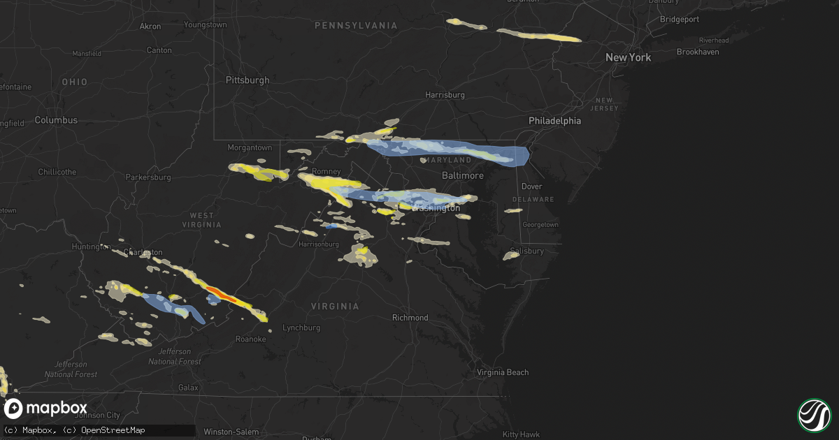
Hail Map in Maryland on July 12, 2022
Get this storm
July 12 map
$229
one time, instant access
Download today. No call, no setup
Keep the $229
Bought the map and want the full workflow? Apply the entire $229 to a subscription within 7 days. None of it is wasted.
Every map, not just this one
This buys you this map. Subscription and you get every map we run, in the markets you choose from a few cities to whole states to nationwide. Plus real-time alerts the moment a storm fires.
Contact data
Name, contact info, occupancy, even credit band for addresses in the footprint. You go from where it hit to who to call.
Become the source they trust
Unlimited branding weather history reports on demand. You already have the documented answer ready for the property owner, and you are the one who showed up with it.
Property data and RoofTrace estimates
Pull up any address you have got, its value and the exact code rules for that jurisdiction, straight from One Click Code. Then RoofTrace estimates the squares, pitch, and roof value, priced the way you price.
Storm reports in Maryland
Maryland
| Date | Description |
|---|---|
| 07/12/20226:29 PM CDT | *** 1 inj *** photo of a camper significantly damaged by a fallen tree at the martinak state park campground. This resulted in one injury to an occupant. Time estimated |
| 07/12/20226:29 PM CDT | Corrects time from previous tstm wnd gst report from 1 ssw denton. Wunderground gauge kmddento27 measured wind gust. |
| 07/12/20226:24 PM CDT | Large trees down and a limb into a car windshield on pealiquor road. Pictures provided via social media. Time estimated via radar. |
| 07/12/20226:00 PM CDT | A tree was down along the george washington parkway. |
| 07/12/20225:59 PM CDT | Wunderground gauge kmdtilgh14 measured wind gust. |
| 07/12/20225:59 PM CDT | Several power lines down on tilghman island resulting in power outages. Utility crews are responding to the area. Time estimated from radar. |
| 07/12/20225:39 PM CDT | Md-665 north at chinquapin round road closed due to downed trees. |
| 07/12/20225:37 PM CDT | Tree down on the road on the 900 block of blue fox way |
| 07/12/20225:32 PM CDT | Tree onto a roof on the 900 block of bramleigh lane |
| 07/12/20225:30 PM CDT | Powerline wires down on the 2000 block of rutland road |
| 07/12/20225:30 PM CDT | Large tree onto a house on the 2000 block of swann way |
| 07/12/20225:27 PM CDT | Several trees down and wires down on the 2000 block of davidsonville road |
| 07/12/20225:27 PM CDT | Tree down blocking the roadway on the 5000 block of southern maryland blvd |
| 07/12/20225:27 PM CDT | Several trees down in hardwood. |
| 07/12/20225:24 PM CDT | Several trees down on vehicles and mobile home structures along 2nd street |
| 07/12/20225:23 PM CDT | Md-424 south past bell branch road closed due to downed trees. |
| 07/12/20225:22 PM CDT | Several trees down around davidsonville. A tree fell onto a house. |
| 07/12/20225:18 PM CDT | Two large trees down near intersection of md 197 and old chapel rd |
| 07/12/20225:16 PM CDT | Multiple trees down blocking the roadway at the intersection of majestic ln. And milan way. |
| 07/12/20225:15 PM CDT | Multiple trees down in the 200 block of morningstar way. |
| 07/12/20225:09 PM CDT | Large tree branches down in the 7900 block of mandan road. |
| 07/12/20225:05 PM CDT | Large tree down on garden way in greenbelt. |
| 07/12/20225:02 PM CDT | Numerous trees down and branches snapped. |
| 07/12/20225:00 PM CDT | Dozens of trees snapped... Uprooted... And sheared in college park. A structure also sustained damage. |
| 07/12/20224:47 PM CDT | Downed tree blocking eastbound river road at springfield drive. |
| 07/12/20224:25 PM CDT | Deos sensor at north east landfill |
| 07/12/20224:23 PM CDT | Tree down along hunting quarter road... East of hughes road. |
| 07/12/20224:21 PM CDT | Large tree limbs down. |
| 07/12/20224:21 PM CDT | Tree down along us-40 west at sycamore drive. |
| 07/12/20224:19 PM CDT | Tree down along us-40 prior to red toad road. |
| 07/12/20224:15 PM CDT | Tree down along md-222 and clayton street. |
| 07/12/20224:15 PM CDT | Phillips airfield |
| 07/12/20224:14 PM CDT | Mddot sensor at tydings bridge |
| 07/12/20224:12 PM CDT | Mddot sensor at hatem bridge |
| 07/12/20224:07 PM CDT | Large tree fell... Crushing an outbuilding and impacting a home |
| 07/12/20224:07 PM CDT | Tree down along md-136 south prior to us-1. |
| 07/12/20224:05 PM CDT | Several large trees and branches down in the 4700 block of sykesville road. |
| 07/12/20224:03 PM CDT | Tree down in the roadway on md-140 just east of the intersection with dede rd. |
| 07/12/20224:01 PM CDT | Tree into windshield of a vehicle. |
| 07/12/20223:59 PM CDT | Tree snapped at residence |
| 07/12/20223:56 PM CDT | Trees down and quarter sized hail. |
| 07/12/20223:56 PM CDT | Trees down and quarter sized hail. |
| 07/12/20223:52 PM CDT | A local report indicates 1.00 inch wind near 2 SSE JARRETTSVILLE |
| 07/12/20223:52 PM CDT | Tree down along md-152 at carrs mill road. |
| 07/12/20223:50 PM CDT | Several large trees down in the 11000 block of harford road. |
| 07/12/20223:46 PM CDT | Tree down along blenheim road north. |
| 07/12/20223:44 PM CDT | Numerous trees snapped and uprooted in the monkton... Sparks... And hereford areas |
| 07/12/20223:44 PM CDT | Approximately 10 trees down along phoenix road. |
| 07/12/20223:44 PM CDT | Numerous trees and powerlines down along paper mill road. |
| 07/12/20223:44 PM CDT | Large tree and branches snapped. |
| 07/12/20223:42 PM CDT | Tree down along md-147 and reckord road. |
| 07/12/20223:42 PM CDT | Tree down along md-543 south and foxborough drive. |
| 07/12/20223:42 PM CDT | Tree down near i-83 south and bunker hill road. |
| 07/12/20223:36 PM CDT | Tree down along i-83 south past middletown road. |
| 07/12/20223:25 PM CDT | Roofing partially removed from a bank in upperco |
| 07/12/20223:25 PM CDT | Numerous large trees and branches down in the 1200 block of allview drive. |
| 07/12/20223:24 PM CDT | Tree reported down on sullivan road near md 27. |
| 07/12/20223:21 PM CDT | Numerous trees down in hampstead area. |
| 07/12/20223:21 PM CDT | Multiple trees down along lees mill rd near aspen run |
| 07/12/20223:20 PM CDT | Trees snapped at the intersection of sullivan rd. And route 27. |
| 07/12/20223:19 PM CDT | Approximately 10 to 12 trees down and snapped. |
| 07/12/20223:19 PM CDT | Large trees and branches snapped in westminster. |
| 07/12/20223:19 PM CDT | Large tree branches down along cobbs choice lane. |
| 07/12/20223:17 PM CDT | Multiple trees... Limbs... And telephone poles snapped. |
| 07/12/20223:15 PM CDT | Part of a metal roof blown off a residence in the 2100 block of littlestown pike and multiple large limbs down. |
| 07/12/20223:12 PM CDT | Over a dozen trees uprooted and 25 to 30 trees snapped near the top. Most of the trees were 18 to 24 inches in diameter. Swath of tree damage nearly 150 feet wide. |
| 07/12/20223:09 PM CDT | Tree down between bullfrog road and baptist road. |
| 07/12/20223:07 PM CDT | Tree down near taneytown pike and bridgeport road. |
| 07/12/20223:00 PM CDT | A local report indicates 60 MPH wind near 3 N WOODSBORO |
| 07/12/20222:59 PM CDT | A local report indicates 1.25 inch wind near EMMITSBURG |
| 07/12/20222:55 PM CDT | Tree and wires down near jimtown road and long road. |
| 07/12/20222:55 PM CDT | Tree down near us-40 and boonsboro mountain road. |
| 07/12/20222:47 PM CDT | Tree down along us-40 at mt lena road. |
| 07/12/20222:28 PM CDT | Tree and wires down in the 14000 block of national pike. |
| 07/12/20222:26 PM CDT | Trees down near st. Paul road and fairview road. |
| 07/12/20222:23 PM CDT | Tree and wires down in the 11000 block of orebank road. |
| 07/12/20222:22 PM CDT | Large tree down. |
| 07/12/20222:02 PM CDT | A local report indicates 1.25 inch wind near 2 WNW BELLEGROVE |
| 07/12/20221:57 PM CDT | Tree and wires down in the 3400 block of western pike. |
| 07/12/20221:57 PM CDT | Tree down on a power line at the intersection of kempton rd. And gregory ln. |
| 07/12/20221:40 PM CDT | Tree down on a line on twin churches rd. |
| 07/12/20221:12 PM CDT | Tree down near the intersection of white rock crosscut road and trap run road |
| 07/12/20226:59 AM CDT | At 1159 PM EDT, a severe thunderstorm was located over Fort A.p. Hill, or near Bowling Green, moving east at 35 mph. HAZARD...60 mph wind gusts. SOURCE...Radar indicated. IMPACT...Expect damage to trees and powerlines. This severe thunderstorm will be near... Port Royal around 1210 AM EDT. Leedstown and Loretto around 1225 AM EDT. Champlain around 1230 AM EDT. Montross and Newland around 1240 AM EDT.Other locations impacted by this severe thunderstorm includeRappahannock Academy, Lerty, Villboro, Hustle, Corbin, Oak Grove,Supply, Singerly, Peeds and Foneswood. |
| 07/12/20224:03 AM CDT | At 903 PM EDT, severe thunderstorms were located along a line extending from California to near Saint Marys River to near Saint George Island, moving east at 55 mph. HAZARD...60 mph wind gusts and quarter size hail. SOURCE...Radar indicated. IMPACT...Damaging winds will cause some trees and large branches to fall. This could injure those outdoors, as well as damage homes and vehicles. Roadways may become blocked by downed trees. Localized power outages are possible. Unsecured light objects may become projectiles. Locations impacted include... Lexington Park, Chesapeake Ranch Estates, Piney Point, Tall Timbers, Saint Inigoes Creek, Cuckold Creek, Saint Marys City, Saint George Island, Town Creek, Saint Marys River, White Point Beach, California, Lusby, Patuxent River Naval Air Station, Drum Point, Valley Lee, Scotland, Great Mills, Drayden and Saint Inigoes. |
| 07/12/20222:44 AM CDT | At 743 PM EDT, severe thunderstorms were located along a line extending from 10 miles northwest of Stafford to 11 miles southeast of Culpeper, moving southeast at 45 mph. HAZARD...60 mph wind gusts and quarter size hail. SOURCE...Radar indicated. IMPACT...Damaging winds will cause some trees and large branches to fall. This could injure those outdoors, as well as damage homes and vehicles. Roadways may become blocked by downed trees. Localized power outages are possible. Unsecured light objects may become projectiles. Locations impacted include... Stafford, Fredericksburg, King George, Dahlgren, Fairview Beach, Potomac Creek, Nanjemoy Creek, Aquia Creek, Wicomico River, Port Royal, Massaponax, Spotsylvania, Falmouth, Passapatanzy, Cobb Island, Stones Corner, Potomac Beach, Weedonville, Roseville and Ninde. |
| 07/12/20222:40 AM CDT | At 740 PM EDT, a severe thunderstorm was located near Linton Hall, or 12 miles west of Dale City, moving southeast at 40 mph. HAZARD...60 mph wind gusts and quarter size hail. SOURCE...Radar indicated. IMPACT...Damaging winds will cause some trees and large branches to fall. This could injure those outdoors, as well as damage homes and vehicles. Roadways may become blocked by downed trees. Localized power outages are possible. Unsecured light objects may become projectiles. Locations impacted include... Dale City, Fort Belvoir, Woodbridge, Quantico, Lake Ridge, Linton Hall, Montclair, Lorton, Bull Run, Newington, Triangle, Dumfries, Manassas, Sudley, Cherry Hill, Manassas Park, Mount Vernon, Independent Hill, Bryans Road and Mason Neck. |
| 07/12/20222:37 AM CDT | At 736 PM EDT, a severe thunderstorm was located near Andrewsville, or 17 miles northeast of Hurlock, moving east at 45 mph. THIS IS A DESTRUCTIVE STORM FOR ANDREWSVILLE AND FARMINGTON. HAZARD...80 mph wind gusts and quarter size hail. SOURCE...Radar indicated. IMPACT...Flying debris will be dangerous to those caught without shelter. Mobile homes will be heavily damaged. Expect considerable damage to roofs, windows, and vehicles. Extensive tree damage and power outages are likely. Locations impacted include... Milford, Harrington, Ellendale, Andrewsville, Greenwood, Houston and Farmington. |
| 07/12/20221:40 AM CDT | At 640 PM EDT, a severe thunderstorm was located over Annapolis, moving east at 35 mph. HAZARD...70 mph wind gusts and quarter size hail. SOURCE...Radar indicated. IMPACT...Damaging winds will cause some trees and large branches to fall. This could injure those outdoors, as well as damage homes and vehicles. Roadways may become blocked by downed trees. Localized power outages are possible. Unsecured light objects may become projectiles. Locations impacted include... Annapolis, Naval Academy, Magothy River, Dobbins Island, Severn River, Pinehurst, Gibson Island, Sillery Bay, Severna Park, Arnold, Lake Shore, Parole, Edgewater, Cape St. Claire, Riva, Herald Harbor, Crownsville, Highland Beach, Belvedere Heights and Navy-Marine Corps Stadium. |
| 07/12/20221:36 AM CDT | At 636 PM EDT, severe thunderstorms were located along a line extending from near Arnold to Severn River to near Deale, moving east at 45 mph. HAZARD...70 mph wind gusts and quarter size hail. SOURCE...Radar indicated. IMPACT...Minor damage to vehicles is possible. Expect considerable tree damage. Wind damage is also likely to mobile homes, roofs, and outbuildings. Locations impacted include... Easton, Centerville, Talbot, Centreville, Greensboro, Oakland, Ridgely, Rock Hall, Trappe, St. Michaels, Church Hill, Oxford, Goldsboro, Queen Anne, Old Town, Grasonville, Starr, Copperville, Jumptown and Windyhill. |
| 07/12/20221:00 AM CDT | At 559 PM EDT, a severe thunderstorm was located over Colesville, or near Olney, moving east at 40 mph. HAZARD...60 mph wind gusts and quarter size hail. SOURCE...Radar indicated. IMPACT...Damaging winds will cause some trees and large branches to fall. This could injure those outdoors, as well as damage homes and vehicles. Roadways may become blocked by downed trees. Localized power outages are possible. Unsecured light objects may become projectiles. Locations impacted include... Columbia, Bowie, Severn, Annapolis, Olney, Crofton, Beltsville, Naval Academy, Severn River, Gibson Island, Sillery Bay, Magothy River, Dobbins Island, Pinehurst, Glen Burnie, Aspen Hill, Severna Park, Odenton, Laurel and Pasadena. |
| 07/12/202212:29 AM CDT | At 529 PM EDT, a severe thunderstorm was located over Hollywood Beach, or 8 miles southwest of Elkton, moving east at 45 mph. HAZARD...60 mph wind gusts and quarter size hail. SOURCE...Radar indicated. IMPACT...Minor damage to vehicles is possible. Wind damage to roofs, siding, trees, and power lines is possible. Locations impacted include... Middletown, Salem, Delaware City, Saint Georges, Port Penn, Mount Pleasant, Glasgow, Bear and Odessa. |
| 07/12/202212:04 AM CDT | At 503 PM EDT, severe thunderstorms were located along a line extending from near Purcellville to 6 miles southeast of Hume, moving east at 50 mph. HAZARD...60 mph wind gusts and quarter size hail. SOURCE...Radar indicated. IMPACT...Damaging winds will cause some trees and large branches to fall. This could injure those outdoors, as well as damage homes and vehicles. Roadways may become blocked by downed trees. Localized power outages are possible. Unsecured light objects may become projectiles. Locations impacted include... Germantown, Centreville, Dale City, Rockville, Bethesda, Gaithersburg, Reston, Leesburg, Annandale, South Riding, Herndon, Fairfax, Vienna, Falls Church, Broadlands, Lansdowne, Lowes Island, Brambleton, Mantua and Pimmit Hills. |
| 07/11/202211:44 PM CDT | At 444 PM EDT, a severe thunderstorm was located near Mount Airy, or 10 miles north of Damascus, moving east at 50 mph. HAZARD...60 mph wind gusts and quarter size hail. SOURCE...Radar indicated. IMPACT...Damaging winds will cause some trees and large branches to fall. This could injure those outdoors, as well as damage homes and vehicles. Roadways may become blocked by downed trees. Localized power outages are possible. Unsecured light objects may become projectiles. Locations impacted include... Pikesville, Westminster, Randallstown, Owings Mills, Eldersburg, Milford Mill, Reisterstown, Lochearn, Mount Airy, Sykesville, Oakland, New Market, Gamber, Garrison, New Windsor, Libertytown, Monrovia, Finksburg, Carrollton and Upperco. |
| 07/11/202211:35 PM CDT | At 435 PM EDT, severe thunderstorms were located along a line extending from near Cockeysville to near Owings Mills to near Eldersburg, moving east at 65 mph. HAZARD...60 mph wind gusts. SOURCE...Radar indicated. IMPACT...Damaging winds will cause some trees and large branches to fall. This could injure those outdoors, as well as damage homes and vehicles. Roadways may become blocked by downed trees. Localized power outages are possible. Unsecured light objects may become projectiles. Locations impacted include... Baltimore, Pikesville, Middle River, Cockeysville, Back River, Millers Island, Dundalk, Towson, Essex, Randallstown, Parkville, Owings Mills, Carney, Milford Mill, Perry Hall, Reisterstown, Lochearn, Rosedale, Rossville and Mays Chapel. |
| 07/11/202211:27 PM CDT | At 427 PM EDT, severe thunderstorms were located along a line extending from near Berryville to 9 miles southwest of Front Royal, moving east at 55 mph. HAZARD...60 mph wind gusts and quarter size hail. SOURCE...Radar indicated. IMPACT...Damaging winds will cause some trees and large branches to fall. This could injure those outdoors, as well as damage homes and vehicles. Roadways may become blocked by downed trees. Localized power outages are possible. Unsecured light objects may become projectiles. Locations impacted include... Leesburg, South Riding, Broadlands, Lansdowne, Brambleton, Ashburn, Linton Hall, Purcellville, Haymarket, Middleburg, Round Hill, Arcola, The Plains, Delaplane, Hume, Oatlands, Bluemont, Gainesville, New Baltimore and Belmont. |
| 07/11/202211:22 PM CDT | A local report indicates 60 MPH wind near 3 ENE DAHLGREN |
| 07/11/202210:30 PM CDT | Wunderground gauge kmddento27 measured wind gust. |
| 07/11/202210:08 PM CDT | At 307 PM EDT, severe thunderstorms were located along a line extending from Elk Garden to near Davis, moving east at 50 mph. HAZARD...60 mph wind gusts and quarter size hail. SOURCE...Radar indicated. IMPACT...Damaging winds will cause some trees and large branches to fall. This could injure those outdoors, as well as damage homes and vehicles. Roadways may become blocked by downed trees. Localized power outages are possible. Unsecured light objects may become projectiles. Locations impacted include... Moorefield, Petersburg, Elk Garden, Kitzmiller, Mathias, Burlington, Russelldale, Bean Settlement, Arthur, Hartmansville, New Creek, Seymourville, Lahmansville, Masonville, Lost City, Cabins, Lost River, Hopeville, Delray and Dorcas. |
| 07/11/202210:04 PM CDT | At 304 PM EDT, a severe thunderstorm was located over St. Thomas, moving east at 25 mph. HAZARD...60 mph wind gusts and quarter size hail. SOURCE...Radar indicated. IMPACT...Hail damage to vehicles is expected. Expect wind damage to roofs, siding, and trees. Locations impacted include... Chambersburg, Waynesboro, Gettysburg, Shippensburg, Greencastle, Guilford, St. Thomas, Carroll Valley, Fayetteville, Wayne Heights, Mont Alto and Scotland.This includes Interstate 81 from mile markers 0 to 37. |
| 07/11/20229:56 PM CDT | At 256 PM EDT, severe thunderstorms were located along a line extending from near La Vale to near Piedmont, moving southeast at 45 mph. HAZARD...60 mph wind gusts and quarter size hail. SOURCE...Radar indicated. IMPACT...Damaging winds will cause some trees and large branches to fall. This could injure those outdoors, as well as damage homes and vehicles. Roadways may become blocked by downed trees. Localized power outages are possible. Unsecured light objects may become projectiles. Locations impacted include... Romney, Paw Paw, Fort Ashby, Springfield, Capon Bridge, Green Spring, Burlington, Oldtown, Spring Gap, Shanks, Fishers Bridge, North Branch, Bloomery, Reeses Mill, Points, Delray, Junction, Wapocomo, Augusta and Patterson Creek. |
| 07/11/20229:48 PM CDT | At 247 PM EDT, a severe thunderstorm was located 8 miles south of Rowlesburg, moving southeast at 35 mph. HAZARD...60 mph wind gusts and quarter size hail. SOURCE...Radar indicated. IMPACT...Minor hail damage to vehicles is possible. Expect wind damage to trees and power lines, resulting in some power outages. Locations impacted include... Parsons, Davis, Thomas, Rowlesburg, Hendricks, Hambleton, Hannahsville, Elk, Canaan Valley State Park, Pheasant Run, Aurora, and Davisville. |
| 07/11/20229:46 PM CDT | At 246 PM EDT, a severe thunderstorm was located over Lake Gordon, moving east at 35 mph. HAZARD...60 mph wind gusts and quarter size hail. SOURCE...Radar indicated. IMPACT...Hail damage to vehicles is expected. Expect wind damage to roofs, siding, and trees. Locations impacted include... Warfordsburg, Needmore, Lake Gordon, Barnes Gap, Inglesmith, Locust Grove and Hyndman.This includes Interstate 70 from mile markers 154 to 170. |
| 07/11/20229:37 PM CDT | At 237 PM EDT, a severe thunderstorm was located over Warfordsburg, moving east at 30 mph. HAZARD...60 mph wind gusts. SOURCE...Radar indicated. IMPACT...Expect damage to roofs, siding, and trees. Locations impacted include... Chambersburg, Greencastle, Guilford, St. Thomas, Warfordsburg, Mercersburg, Scotland, Marion, Fort Loudon, Big Cove Tannery, Needmore and Claylick.This includes the following Interstates... Interstate 70 from mile markers 168 to 169. Interstate 81 from mile markers 0 to 18. |
| 07/11/20229:26 PM CDT | Mt hermon rd *md-350* closed at airport road due to downed trees on the roadway. |
| 07/11/20229:25 PM CDT | At 224 PM EDT, severe thunderstorms were located along a line extending from near Grantsville to near Grafton, moving east at 45 mph. HAZARD...60 mph wind gusts and quarter size hail. SOURCE...Radar indicated. IMPACT...Damaging winds will cause some trees and large branches to fall. This could injure those outdoors, as well as damage homes and vehicles. Roadways may become blocked by downed trees. Localized power outages are possible. Unsecured light objects may become projectiles. Locations impacted include... Cumberland, Frostburg, Keyser, Mountain Lake Park, Oakland, Westernport, Bel Air, Bayard, Bittinger, La Vale, Lonaconing, Piedmont, Grantsville, Loch Lynn Heights, Deer Park, Accident, Elk Garden, Kitzmiller, Ridgeley and Cresaptown. |
| 07/11/20229:25 PM CDT | Trees downed at powell ave off us-13. Additional report in the area reported via mping. |
| 07/11/20229:19 PM CDT | At 219 PM EDT, a severe thunderstorm was located 8 miles southeast of Grafton, moving east at 50 mph. HAZARD...60 mph wind gusts and quarter size hail. SOURCE...Radar indicated. IMPACT...Minor hail damage to vehicles is possible. Expect wind damage to trees and power lines, resulting in some power outages. Locations impacted include... Parsons, Davis, Thomas, Rowlesburg, Hannahsville, Elgon, Benbush, Lead Mine, Pifer Moutain, Silver Lake, Aurora, and Blackwater Falls. |
| 07/11/20229:17 PM CDT | Corrects previous tstm wnd dmg report from 1 sse lakewood. Corrects previous tstm wnd dmg report from 1 sse lakewood. Multiple large diameter limbs 7-8 inches knocked d |
| 07/11/20228:57 PM CDT | At 157 PM EDT, a severe thunderstorm was located near Newburg, or 9 miles west of Kingwood, moving east at 60 mph. HAZARD...60 mph wind gusts and quarter size hail. SOURCE...Radar indicated. IMPACT...Minor hail damage to vehicles is possible. Expect wind damage to trees and power lines, resulting in some power outages. Locations impacted include... Morgantown, Fairmont, Kingwood, Terra Alta, Rowlesburg, Pleasant Valley, Winfield, Barrackville, Monongah, Newburg, Brookhaven, and Rivesville. |
| 07/11/20228:23 PM CDT | Gust to 51 kt at hoopers island weatherflow. |
| 07/11/20228:20 PM CDT | A local report indicates 58 MPH wind near 10 ESE COVE POINT |
| 07/11/20227:58 PM CDT | Numerous trees down in mechanicsville. A tree fell onto a mobile home along riverview road. |
| 07/11/20227:48 PM CDT | Numerous trees down in mechanicsville. A tree fell onto a mobile home along riverview road. |
| 07/11/20227:47 PM CDT | Tree down on md-242 at bachelors rest lane. |
| 07/11/20227:44 PM CDT | Tree down near md-238 at doctor johnson road. |
| 07/11/20227:41 PM CDT | Tree down on beach dr. At colton's point. |
| 07/11/20227:36 PM CDT | A tree blew down on budds creek rd. |
| 07/11/20227:32 PM CDT | A tree blew down on stonestreet rd. |
| 07/11/20227:32 PM CDT | A local report indicates 60 MPH wind near 3 ENE DAHLGREN |
| 07/11/20227:31 PM CDT | Mulitple trees...total of 8...uprooted or snapped mix of hard/softwood off brunswick rd |
| 07/11/20227:29 PM CDT | Tree down near md-234 and us 301. |
| 07/11/20227:29 PM CDT | A few trees blew down near popes creek rd. |
All States Impacted by Hail Map on July 12, 2022
Cities Impacted by Hail Map on July 12, 2022
- Verndale, MN
- Aldrich, MN
- Staples, MN
- Pierz, MN
- Climax, NY
- Coxsackie, NY
- Deer River, MN
- Briggsdale, CO
- East Meredith, NY
- Treadwell, NY
- Delhi, NY
- New Raymer, CO
- Mathias, WV
- Drums, PA
- Mount Bethel, PA
- Columbia, NJ
- Kunkletown, PA
- Great Meadows, NJ
- Effort, PA
- Andover, NJ
- Portland, PA
- Freeland, PA
- Lake Harmony, PA
- Blairstown, NJ
- Brodheadsville, PA
- Stanhope, NJ
- Albrightsville, PA
- White Haven, PA
- Hazleton, PA
- Weatherly, PA
- Bangor, PA
- Stroudsburg, PA
- East Stroudsburg, PA
- Hackettstown, NJ
- Jim Thorpe, PA
- Saylorsburg, PA
- Hillman, MN
- Foley, MN
- Tracys Landing, MD
- Dunkirk, MD
- Upper Marlboro, MD
- Churchton, MD
- Deale, MD
- Lothian, MD
- Long Eddy, NY
- Hume, VA
- Markham, VA
- Marshall, VA
- Linden, VA
- Akeley, MN
- Walker, MN
- Shady Spring, WV
- Hinton, WV
- Hinton, VA
- Fulks Run, VA
- Singers Glen, VA
- Harrisonburg, VA
- Linville, VA
- Stuyvesant, NY
- Kinderhook, NY
- Danville, PA
- Millville, PA
- Muncy, PA
- Orangeville, PA
- Berwick, PA
- Turbotville, PA
- Watsontown, PA
- Bloomsburg, PA
- Shinnston, WV
- Bridgeport, WV
- Fairmont, WV
- Gormania, WV
- Terra Alta, WV
- Enterprise, WV
- Worthington, WV
- Eglon, WV
- Newburg, WV
- Moatsville, WV
- Oakland, MD
- Tunnelton, WV
- Independence, WV
- Parsons, WV
- Aurora, WV
- Rowlesburg, WV
- Thornton, WV
- Grafton, WV
- Flemington, WV
- Iaeger, WV
- Welch, WV
- Davy, WV
- Kimball, WV
- Chicopee, MA
- Monson, MA
- Hampden, MA
- Springfield, MA
- Indian Orchard, MA
- Southampton, MA
- Holyoke, MA
- Wilbraham, MA
- Wales, MA
- Ludlow, MA
- West Springfield, MA
- Westfield, MA
- Wardensville, WV
- Webster Springs, WV
- Elk Garden, WV
- Keyser, WV
- Lacrosse, WA
- Saint John, WA
- Endicott, WA
- Thornton, WA
- Colfax, WA
- Fayetteville, WV
- Lenore, WV
- Kermit, WV
- Pineville, KY
- Nunn, CO
- Beckley, WV
- Beaver, WV
- Eagle Bridge, NY
- North Bennington, VT
- Cambridge, NY
- Middletown, DE
- Wiggins, CO
- Fort Morgan, CO
- Carr, CO
- Simsbury, CT
- Tariffville, CT
- Bloomfield, CT
- Boonville, NY
- Woodgate, NY
- Forestport, NY
- Hawkins, WI
- Glen Flora, WI
- Stephens City, VA
- Middletown, VA
- Front Royal, VA
- Motley, MN
- Cushing, MN
- Browerville, MN
- Brandywine, WV
- Huntington, WV
- Ona, WV
- Barboursville, WV
- Sterling, CO
- Atwood, CO
- Akron, CO
- Merino, CO
- Medford, WI
- Merriman, NE
- Whitman, NE
- Pequot Lakes, MN
- Brainerd, MN
- Pine River, MN
- Nisswa, MN
- Baxter, MN
- Log Lane Village, CO
- Snyder, CO
- Hillrose, CO
- Brush, CO
- Athens, NY
- Catskill, NY
- Cheyenne, WY
- Glen White, WV
- Lester, WV
- Coal City, WV
- Princewick, WV
- Slab Fork, WV
- Crab Orchard, WV
- Josephine, WV
- Rhodell, WV
- Midway, WV
- Sophia, WV
- Cossayuna, NY
- Argyle, NY
- Schuylerville, NY
- Corinth, NY
- Manchester, VT
- Salem, NY
- Pawlet, VT
- Londonderry, VT
- Greenfield Center, NY
- Manchester Center, VT
- West Rupert, VT
- Arlington, VT
- Saratoga Springs, NY
- West Pawlet, VT
- Peru, VT
- Bondville, VT
- Fort Edward, NY
- Granville, NY
- Porter Corners, NY
- Shushan, NY
- Greenwich, NY
- Jamaica, VT
- Dorset, VT
- East Dorset, VT
- Gansevoort, NY
- East Arlington, VT
- Cody, NE
- Merrifield, MN
- Crosby, MN
- Crosslake, MN
- Lisco, NE
- Suncook, NH
- Goshen, NH
- Epsom, NH
- Lempster, NH
- Contoocook, NH
- Charlestown, NH
- Claremont, NH
- Bradford, NH
- Bow, NH
- Loudon, NH
- Washington, NH
- South Acworth, NH
- Chichester, NH
- Henniker, NH
- Concord, NH
- Newport, NH
- Hillsborough, NH
- Dunbarton, NH
- Acworth, NH
- Warner, NH
- Foster, RI
- Dayville, CT
- Chepachet, RI
- Danielson, CT
- East Killingly, CT
- North Scituate, RI
- Roscoe, NY
- Otis, CO
- Davenport, NY
- West Davenport, NY
- Oneonta, NY
- Davenport Center, NY
- Francestown, NH
- New Boston, NH
- Goffstown, NH
- Weare, NH
- Hooksett, NH
- Auburn, NH
- Manchester, NH
- Greenfield, NH
- Bedford, NH
- Bennington, NH
- Rileyville, VA
- Luray, VA
- Edinburg, VA
- Mount Jackson, VA
- Fort Valley, VA
- Ashford, CT
- Eastford, CT
- Tolland, CT
- Pomfret Center, CT
- Willington, CT
- North Clarendon, VT
- Rutland, VT
- Castleton, VT
- Cuttingsville, VT
- Center Rutland, VT
- Killington, VT
- Bomoseen, VT
- Chittenden, VT
- Florence, VT
- Proctor, VT
- West Rutland, VT
- Pittsford, VT
- Townshend, VT
- Keene, NH
- Sullivan, NH
- Walpole, NH
- Stoddard, NH
- Gilsum, NH
- Westminster, VT
- Alstead, NH
- Antrim, NH
- Marlow, NH
- Nelson, NH
- Chester, VT
- Putney, VT
- Newfane, VT
- Hancock, NH
- Big Indian, NY
- Phoenicia, NY
- Claryville, NY
- Bemidji, MN
- Gurley, NE
- Greenville Junction, ME
- Breeden, WV
- Livingston, TN
- Monticello, MN
- Maple Lake, MN
- Clearwater, MN
- Frederick, MD
- Union Bridge, MD
- Mount Airy, MD
- Jackson, KY
- Clayhole, KY
- Bethel Springs, TN
- Crown City, OH
- Franklin, WV
- Riverton, WV
- Circleville, WV
- Deer Trail, CO
- South Charleston, WV
- Saint Albans, WV
- Tornado, WV
- Michie, TN
- Counce, TN
- Savannah, TN
- Columbia, KY
- Russell Springs, KY
- Rock Creek, WV
- Glen Daniel, WV
- Williamsburg, KY
- Newtonville, NJ
- Mays Landing, NJ
- Denniston, KY
- Frenchburg, KY
- Lascassas, TN
- Woodbury, TN
- Readyville, TN
- Bell Buckle, TN
- Murfreesboro, TN
- Milton, TN
- Bradyville, TN
- Christiana, TN
- Boncarbo, CO
- Weston, CO
- Trinidad, CO
- Union, WV
- Lindside, WV
- Glens Fork, KY
- Jamestown, KY
- Tompkinsville, KY
- Mount Ida, AR
- Red Boiling Springs, TN
- Lafayette, TN
- Pleasant Shade, TN
- Riddleton, TN
- Dixon Springs, TN
- Corinth, MS
- Waynesboro, TN
- Westpoint, TN
- Iron City, TN
- Lawrenceburg, TN
- Collinwood, TN
- Bandy, VA
- North Tazewell, VA
- Jewell Ridge, VA
- Berwind, WV
- Squire, WV
- Little Rock, AR
- Paint Rock, TX
- Eden, TX
- Amarillo, TX
- Valley Spring, TX
- Wartburg, TN
- Oliver Springs, TN
- Great Falls, VA
- Sterling, VA
- Poolesville, MD
- Potomac, MD
- Romney, WV
- Shanks, WV
- Rio, WV
- Morgan City, LA
- Paron, AR
- Benton, AR
- Iliff, CO
- Gloversville, NY
- Franklin, TN
- Monticello, KY
- Corbin, KY
- Ferguson, KY
- Whitley City, KY
- Bethelridge, KY
- Bronston, KY
- Burnside, KY
- Nancy, KY
- Parkers Lake, KY
- Stearns, KY
- Science Hill, KY
- Somerset, KY
- Dunnville, KY
- Eubank, KY
- Liberty, KY
- Windsor, KY
- Chapmanville, WV
- Indian Head, MD
- Nanjemoy, MD
- Schriever, LA
- Cuero, TX
- Llano, TX
- Chantilly, VA
- Aldie, VA
- Woodrow, CO
- Hot Springs Village, AR
- Lonsdale, AR
- Warfordsburg, PA
- Chevy Chase, MD
- Takoma Park, MD
- College Park, MD
- Lanham, MD
- Hyattsville, MD
- Bowie, MD
- Glenn Dale, MD
- Washington, DC
- Greenbelt, MD
- Riverdale, MD
- Silver Spring, MD
- Beltsville, MD
- Chapel Hill, TN
- Ghent, WV
- Jumping Branch, WV
- Cool Ridge, WV
- Nimitz, WV
- Pipestem, WV
- Arrington, TN
- College Grove, TN
- Dequincy, LA
- Starks, LA
- Columbia, TN
- Big Rock, VA
- Grundy, VA
- Mason, TX
- Conway, AR
- Gauley Bridge, WV
- Asbury, WV
- Caldwell, WV
- Eagle Rock, VA
- Buchanan, VA
- Montgomery, WV
- White Sulphur Springs, WV
- Ronceverte, WV
- Pond Gap, WV
- Rainelle, WV
- Hico, WV
- Smoot, WV
- Lewisburg, WV
- Maxwelton, WV
- Belle, WV
- Hugheston, WV
- Fincastle, VA
- Ansted, WV
- Rupert, WV
- Victor, WV
- Blount, WV
- Charmco, WV
- Lookout, WV
- Quinwood, WV
- Williamsburg, WV
- Pratt, WV
- Mammoth, WV
- Cedar Grove, WV
- Lansing, WV
- Crawley, WV
- Danese, WV
- Covington, VA
- Nallen, WV
- Culleoka, TN
- Norman, AR
- Westminster, MD
- Manchester, MD
- Taneytown, MD
- Harts, WV
- Hurricane, WV
- Winfield, WV
- Unionville, TN
- Shelbyville, TN
- Lewisburg, TN
- Eagleville, TN
- Rockvale, TN
- Panhandle, TX
- Holland, KY
- Scottsville, KY
- Weimar, TX
- Austin, KY
- Glasgow, KY
- Fountain Run, KY
- Lucas, KY
- Walsenburg, CO
- Avondale, CO
- Meridianville, AL
- Alderson, WV
- Yorktown, TX
- West Coxsackie, NY
- Menard, TX
- Dyke, VA
- Stanardsville, VA
- Fort Scott, KS
- Adolphus, KY
- Herndon, VA
- Fairdale, WV
- Saxon, WV
- Bolt, WV
- Surveyor, WV
- Delaplane, VA
- Cottontown, TN
- Portland, TN
- Inez, KY
- Tomahawk, KY
- Debord, KY
- Pioneer, TN
- Livingston, KY
- East Bernstadt, KY
- Sherwood, AR
- Lebanon, TN
- Harrogate, TN
- Gray, KY
- Barbourville, KY
- Heidrick, KY
- McLean, VA
- Vienna, VA
- Reston, VA
- Oakpark, VA
- Ruckersville, VA
- Hood, VA
- Orange, VA
- Reva, VA
- Pratts, VA
- Gordonsville, VA
- Madison, VA
- Unionville, VA
- Locust Dale, VA
- Radiant, VA
- Haywood, VA
- Rapidan, VA
- Brightwood, VA
- Somerset, VA
- Aroda, VA
- Leon, VA
- Barboursville, VA
- Rochelle, VA
- Culpeper, VA
- Mayflower, AR
- Arlington, VA
- Delray, WV
- Augusta, WV
- Stafford, VA
- Fredericksburg, TX
- Doss, TX
- Herndon, WV
- Pineville, WV
- New Richmond, WV
- Saulsville, WV
- Cabot, AR
- Jacksonville, AR
- Vilonia, AR
- Romance, AR
- Mount Vernon, AR
- Boston, VA
- Sperryville, VA
- Thurmont, MD
- Emmitsburg, MD
- Sabillasville, MD
- Keymar, MD
- Rocky Ridge, MD
- Rocksprings, TX
- Smiths Grove, KY
- Bowling Green, KY
- Gamaliel, KY
- Oakland, KY
- Westmoreland, TN
- Park City, KY
- Franklin, KY
- Mount Juliet, TN
- Round Hill, VA
- Bluemont, VA
- Granville, TN
- Summertown, TN
- Lynnville, TN
- Ethridge, TN
- Pulaski, TN
- Mount Pleasant, TN
- Smyrna, TN
- Nolensville, TN
- Hancock, MD
- Annapolis, MD
- Crownsville, MD
- Arnold, MD
- Jessieville, AR
- Malvern, AR
- Fletcher, NC
- Etlan, VA
- Mercersburg, PA
- Greencastle, PA
- Denton, MD
- Harrington, DE
- Cordova, MD
- Greenwood, DE
- Greenbrier, AR
- Enola, AR
- Elk Horn, KY
- Campbellsville, KY
- Searcy, AR
- Pine Knot, KY
- Bedford, VA
- Thaxton, VA
- Albany, KY
- Burkesville, KY
- Caryville, TN
- The Plains, VA
- Ewing, VA
- Ozona, TX
- Adamsville, TN
- Valley Head, WV
- New Market, VA
- Quicksburg, VA
- Ashburn, VA
- Leesburg, VA
- Middleburg, VA
- Purcellville, VA
- Chatham, NY
- Maumelle, AR
- North Little Rock, AR
- Lindon, CO
- Anton, CO
- Miami, WV
- Eskdale, WV
- Winifrede, WV
- Hernshaw, WV
- Comfort, WV
- Drybranch, WV
- Hansford, WV
- Cabin Creek, WV
- Gallagher, WV
- Bivalve, MD
- Quantico, MD
- Vienna, MD
- Tyaskin, MD
- Eden, MD
- Nanticoke, MD
- Forest Hill, MD
- Monkton, MD
- Jarrettsville, MD
- Aberdeen, MD
- Bel Air, MD
- Fallston, MD
- Churchville, MD
- Calvin, KY
- Pecks Mill, WV
- Logan, WV
- Lake, WV
- Amherstdale, WV
- Yolyn, WV
- Gainesville, VA
- Warrenton, VA
- Nokesville, VA
- Bristow, VA
- Catharpin, VA
- Manassas, VA
- Haymarket, VA
- Broad Run, VA
- Greensburg, KY
- Grand Chenier, LA
- Fredericksburg, VA
- Cannon, KY
- Middlesboro, KY
- Flat Lick, KY
- Artemus, KY
- Frakes, KY
- Trosper, KY
- Bimble, KY
- Rockholds, KY
- Bryants Store, KY
- Whitewood, VA
- Oakwood, VA
- Raven, VA
- Pilgrims Knob, VA
- Hallettsville, TX
- Mertzon, TX
- Watertown, TN
- Buffalo Valley, TN
- Whitleyville, TN
- Alexandria, TN
- Gainesboro, TN
- Hilham, TN
- Carthage, TN
- Baxter, TN
- Celina, TN
- Chestnut Mound, TN
- Elmwood, TN
- Brush Creek, TN
- Moss, TN
- Bloomington Springs, TN
- Hestand, KY
- Gordonsville, TN
- Funkstown, MD
- Smithsburg, MD
- Myersville, MD
- Hagerstown, MD
- Thompsons Station, TN
- Chambersburg, PA
- Saint Thomas, PA
- North Spring, WV
- Ikes Fork, WV
- Brentwood, TN
- Fritch, TX
- Borger, TX
- Fairfax, VA
- Oakton, VA
- Oden, AR
- Houston, TX
- Fall River, KS
- Fredonia, KS
- Benedict, KS
- Comfort, TX
- Kerrville, TX
- Toms Brook, VA
- Burlington, WV
- Capon Bridge, WV
- High View, WV
- Yellow Spring, WV
- Purgitsville, WV
- Moorefield, WV
- Maurertown, VA
- Old Fields, WV
- New Creek, WV
- Gore, VA
- Baker, WV
- Byrdstown, TN
- Lahmansville, WV
- Strasburg, VA
- Boyce, VA
- Mount Storm, WV
- Winchester, VA
- Star Tannery, VA
- Berryville, VA
- Crawford, TN
- El Campo, TX
- Wharton, TX
- Knob Lick, KY
- Rickman, TN
- Monterey, TN
- Hunt, TX
- Lyles, TN
- Melvin, TX
- La Vergne, TN
- Broad Brook, CT
- Windsor Locks, CT
- West Suffield, CT
- East Granby, CT
- East Windsor, CT
- Enfield, CT
- Suffield, CT
- Mena, AR
- Hot Springs National Park, AR
- Yoakum, TX
- Southfield, MA
- East Hartland, CT
- Riverton, CT
- Sandisfield, MA
- Somers, CT
- Colebrook, CT
- Ellington, CT
- Granville, MA
- Barkhamsted, CT
- North Granby, CT
- Norfolk, CT
- Southwick, MA
- West Hartland, CT
- Granby, CT
- West Granby, CT
- Katy, TX
- Cypress, TX
- Miles, TX
- Houston, AR
- Bigelow, AR
- Windsor, CT
- Fairfield, PA
- Blue Ridge Summit, PA
- Waynesboro, PA
- Belcamp, MD
- Gettysburg, PA
- Earleville, MD
- Reisterstown, MD
- White Hall, MD
- Hampstead, MD
- Baldwin, MD
- Chesapeake City, MD
- State Line, PA
- Aberdeen Proving Ground, MD
- Sparks Glencoe, MD
- Cascade, MD
- Havre De Grace, MD
- Perryville, MD
- Upperco, MD
- Rouzerville, PA
- North East, MD
- Parkton, MD
- Perry Point, MD
- Elbert, WV
- Paynesville, WV
- Hanover, WV
- Brady, TX
- Sapello, NM
- Speedwell, TN
- Lake Charles, LA
- Hackberry, LA
- Cameron, LA
- Sulphur, LA
- Voca, TX
- Little Orleans, MD
- Artemas, PA
- Flintstone, MD
- Bim, WV
- Chauncey, WV
- Henlawson, WV
- Lyburn, WV
- Omar, WV
- Delbarton, WV
- Switzer, WV
- Holden, WV
- Wharton, WV
- Hewett, WV
- Dingess, WV
- Stollings, WV
- Woodstock, VA
- Milton, WV
- Sod, WV
- Culloden, WV
- Breaks, VA
- Haysi, VA
- Elkhorn City, KY
- Vansant, VA
- Auburntown, TN
- Powellton, WV
- Kimberly, WV
- Robson, WV
- Twilight, WV
- Gilbert, WV
- Baisden, WV
- Wharncliffe, WV
- Caddo Gap, AR
- Florissant, CO
- Orange, TX
- Crofton, MD
- Gambrills, MD
- Medina, TX
- Winsted, CT
- Sheffield, MA
- Monterey, MA
- Canaan, CT
- Great Barrington, MA
- Ashley Falls, MA
- South Windsor, CT
- Mill River, MA
- Northville, NY
- Caroga Lake, NY
- Franklin, VT
- West Stockbridge, MA
- Ghent, NY
- East Chatham, NY
- Austerlitz, NY
- Canaan, NY
- Lenox, MA
- Richmond, MA
- Valatie, NY
- Old Chatham, NY
- Pittsfield, MA
- Upperville, VA
- Reedsville, WV
- Kingwood, WV
- Centreville, VA
- Bergton, VA
- Broadway, VA
- Faulkner, MD
- Bel Alton, MD
- Quantico, VA
- Charlotte Hall, MD
- Welcome, MD
- Newburg, MD
- Port Tobacco, MD
- Mechanicsville, MD
- La Plata, MD
- Bedford, PA
- Clearville, PA
- Hyndman, PA
- Meyersdale, PA
- Williamsport, MD
- Big Pool, MD
- Berkeley Springs, WV
- Needmore, PA
- Big Cove Tannery, PA
- Clear Spring, MD
- Pangburn, AR
- Art, TX
- Pontotoc, TX
- Nunnelly, TN
- Centerville, TN
- Perryville, AR
- Florence, AL
- Waterloo, AL
- Cope, CO
- Buna, TX
- Davidsonville, MD
- Severna Park, MD
- Odenton, MD
- Swanton, MD
- Bloomington, MD
- Charleston, WV
- Kensington, MD
- Edgewater, MD
- Mount Rainier, MD
- Garrett Park, MD
- Gaithersburg, MD
- Paris, VA
- Brentwood, MD
- Laurel, MD
- Derwood, MD
- Boyds, MD
- Dunn Loring, VA
- Falls Church, VA
- Dickerson, MD
- Rockville, MD
- Glen Echo, MD
- Riva, MD
- Bethesda, MD
- Olney, MD
- Germantown, MD
- Cross Plains, TN
- Orlinda, TN
- Mount Hermon, KY
- Barton, MD
- Accident, MD
- Grantsville, MD
- McHenry, MD
- Westernport, MD
- Lonaconing, MD
- Gradyville, KY
- Fredonia, TX
- Rixeyville, VA
- Woodville, VA
- Castleton, VA
- Timberville, VA
- Syria, VA
- Los Alamos, NM
- Immokalee, FL
- New Castle, VA
- Huntsville, TN
- Oneida, TN
- Robbins, TN
- Helenwood, TN
- Sunbright, TN
- Olivehill, TN
- Lutts, TN
- Greenville, WV
- Letona, AR
- Catlett, VA
- Creole, LA
- Nitro, WV
- Little Rock Air Force Base, AR
- New Tazewell, TN
- Jamestown, TN
- Indian Mound, TN
- Woodlawn, TN
- Siler, KY
- Sinks Grove, WV
- Allred, TN
- Alpine, TN
- Roland, AR
- Edmonton, KY
- Beattyville, KY
- Iuka, MS
- San Angelo, TX
- Kaplan, LA
- Sonora, TX
- Junction, TX
- Jackman, ME
- Hamilton, VA
- Greenville, ME
- Oneida, WI
- Seymour, WI
- Green Bay, WI
- Victor, CO
- Weldona, CO
- Cabin John, MD
- White Post, VA
- Capitol Heights, MD
- Fort Myer, VA
- Bladensburg, MD
- Boonsboro, MD
- Port Penn, DE
- Rising Sun, MD
- Hedgesville, WV
- Elkton, MD
- Newark, DE
- Maugansville, MD
- Darlington, MD
- Bear, DE
- Warwick, MD
- Delaware City, DE
- Saint Georges, DE
- Woodsboro, MD
- Conowingo, MD
- Port Deposit, MD
- Finksburg, MD
- Abingdon, MD
- New Windsor, MD
- Freeland, MD
- Falling Waters, WV
- Street, MD
- Townsend, DE
- New Castle, DE
- Phoenix, MD
- Colora, MD
- Fairplay, MD
- Cecilton, MD
- Charlestown, MD
- Odessa, DE
- Ballard, WV
- Cyclone, WV
- Glen Fork, WV
- Wayside, WV
- Ravencliff, WV
- Arnett, WV
- Glen Rogers, WV
- Forest Hill, WV
- Naoma, WV
- Odd, WV
- Maben, WV
- Oceana, WV
- Flat Top, WV
- White Oak, WV
- Secondcreekx, WV
- Danby, VT
- Springfield, VT
- Northwood, NH
- Eliot, ME
- York, ME
- Nottingham, NH
- Barrington, NH
- Dover, NH
- South Berwick, ME
- Rollinsford, NH
- Madbury, NH
- Strafford, NH
- West Townshend, VT
- West Wardsboro, VT
- Stafford Springs, CT
- Brimfield, MA
- Palmer, MA
- Marion, PA
- Clothier, WV


