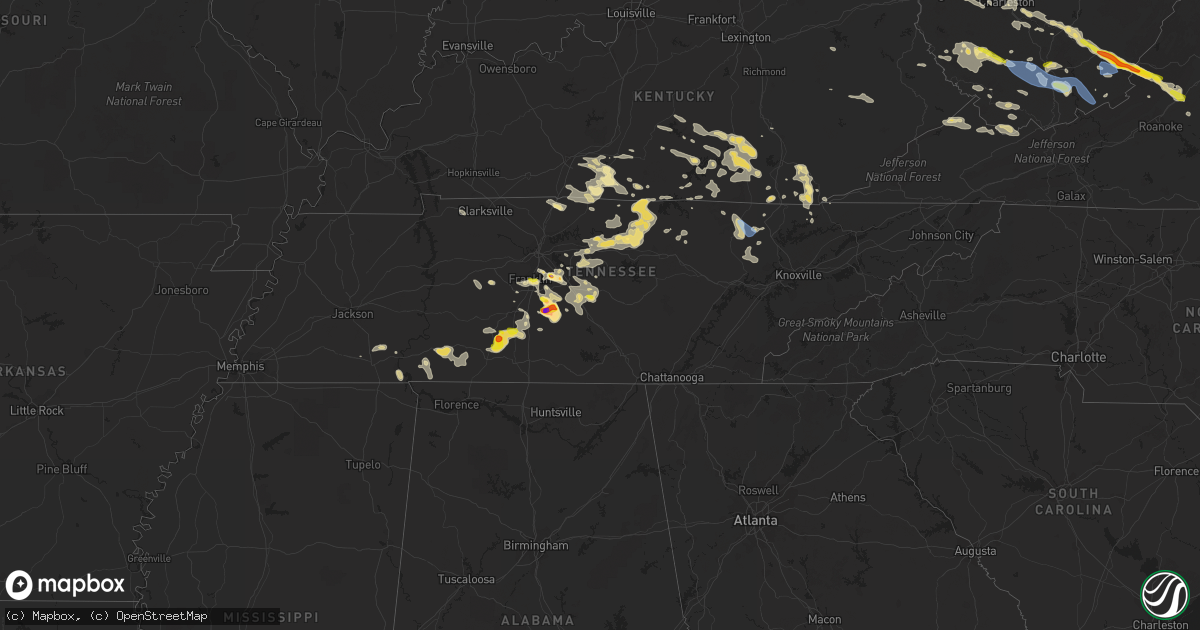
Hail Map in Tennessee on July 12, 2022
Get this storm
July 12 map
$229
one time, instant access
Download today. No call, no setup
Keep the $229
Bought the map and want the full workflow? Apply the entire $229 to a subscription within 7 days. None of it is wasted.
Every map, not just this one
This buys you this map. Subscription and you get every map we run, in the markets you choose from a few cities to whole states to nationwide. Plus real-time alerts the moment a storm fires.
Contact data
Name, contact info, occupancy, even credit band for addresses in the footprint. You go from where it hit to who to call.
Become the source they trust
Unlimited branding weather history reports on demand. You already have the documented answer ready for the property owner, and you are the one who showed up with it.
Property data and RoofTrace estimates
Pull up any address you have got, its value and the exact code rules for that jurisdiction, straight from One Click Code. Then RoofTrace estimates the squares, pitch, and roof value, priced the way you price.
Storm reports in Tennessee
Tennessee
| Date | Description |
|---|---|
| 07/12/20226:55 PM CDT | Report of a tree down on a house with time estimated from radar. |
| 07/12/20226:55 PM CDT | Several trees down with time estimated from radar. |
| 07/12/20226:54 PM CDT | Twitter picture of 1 inch hail. Time estimated via radar. |
| 07/12/20226:50 PM CDT | Corrects previous tstm wnd dmg report from 5 ssw readyville. Hail up to quarter size in the 3300 block of cripple creek rd. |
| 07/12/20226:50 PM CDT | Hail up to quarter size in the 3300 block of cripple creek rd. |
| 07/12/20226:50 PM CDT | Several trees down in the 3300 block of cripple creek rd. |
| 07/12/20226:45 PM CDT | Facebook report of trees down... Stop signs down... And trampolines in the road in the grand street area. |
| 07/12/20226:45 PM CDT | Corrects previous hail report from nolensville. Facebook report of trees down... Stop signs down... And trampolines in the road in the grand street area. |
| 07/12/20226:45 PM CDT | Facebook report of golfball size hail on grand street. |
| 07/12/20226:40 PM CDT | Numerous trees down with time estimated from radar. |
| 07/12/20226:34 PM CDT | Report from twitter. |
| 07/12/20226:28 PM CDT | Nickel to quarter size hail reported on carmine street. |
| 07/12/20226:05 PM CDT | Several trees down on roadways with time estimated from radar. |
| 07/12/20225:59 PM CDT | Facebook report of trees and power lines blown down in bloomington springs. |
| 07/12/20225:55 PM CDT | Several trees down over roadways with time estimated from radar. |
| 07/12/20225:40 PM CDT | Trees and powerlines down... Time estimated from radar. |
| 07/12/20225:37 PM CDT | Reports of trees down and power outages in the defeated creek area and across the northern part of the county. |
| 07/12/20225:35 PM CDT | Facebook photos showed trees uprooted in jackson county. |
| 07/12/20225:30 PM CDT | Tree down over roadway with time estimated from radar. |
| 07/12/20225:30 PM CDT | Corrects previous report and is for multiple trees down on roadways. |
| 07/12/20224:57 PM CDT | Facebook report of numerous trees down on highway 53 between gainesboro and celina. |
| 07/12/20225:10 AM CDT | At 1009 PM CDT, a severe thunderstorm was located near Summertown, or 11 miles northeast of Lawrenceburg, moving east at 20 mph. HAZARD...60 mph wind gusts and quarter size hail. SOURCE...Radar indicated. IMPACT...Hail damage to vehicles is expected. Expect wind damage to roofs, siding, and trees. Locations impacted include... Lawrenceburg, Pulaski, Mount Pleasant, Summertown, Cornersville, Ethridge, Lynnville, Henryville and Culleoka.This includes Interstate 65 between mile markers 19 and 32. |
| 07/12/20224:40 AM CDT | At 940 PM CDT, a severe thunderstorm was located 11 miles southeast of Mount Pleasant, or 12 miles south of Columbia, moving southeast at 15 mph. HAZARD...60 mph wind gusts and half dollar size hail. SOURCE...Radar indicated. IMPACT...Hail damage to vehicles is expected. Expect wind damage to roofs, siding, and trees. Locations impacted include... Lewisburg, Lynnville and Culleoka. This includes Interstate 65 between mile markers 27 and 34. |
| 07/12/20224:03 AM CDT | At 903 PM CDT, a severe thunderstorm was located over Franklin, moving east at 15 mph. HAZARD...Ping pong ball size hail and 60 mph wind gusts. SOURCE...Radar indicated. IMPACT...People and animals outdoors will be injured. Expect hail damage to roofs, siding, windows, and vehicles. Expect wind damage to roofs, siding, and trees. Locations impacted include... Franklin, Brentwood, Nolensville, Thompson's Station and Triune. This includes the following highways... Interstate 65 between mile markers 58 and 69. Interstate 840 between mile markers 27 and 41. |
| 07/12/20223:35 AM CDT | At 835 PM EDT, a severe thunderstorm was located over Knoxville, moving southeast at 20 mph. HAZARD...60 mph wind gusts and quarter size hail. SOURCE...Radar indicated. IMPACT...Hail damage to vehicles is expected. Expect wind damage to roofs, siding, and trees. Locations impacted include... Knoxville, Maryville, Sevierville, Alcoa, Dandridge, Louisville, Rockford, Eagleton Village, Strawberry Plains and Halls.This includes the following highways... Interstate 40 in Tennessee between mile markers 377 and 417. Interstate 75 in Tennessee between mile markers 108 and 112. |
| 07/12/20223:33 AM CDT | At 832 PM CDT, severe thunderstorms were located along a line extending from Lynnville to Shelbyville, moving southeast at 10 mph. HAZARD...60 mph wind gusts and quarter size hail. SOURCE...Radar indicated. At 820 PM CDT...teacup size hail was reported in Marshall County with these storms. IMPACT...Hail damage to vehicles is expected. Expect wind damage to roofs, siding, and trees. Locations impacted include... Columbia, Shelbyville, Lewisburg, Pulaski, Chapel Hill, Cornersville, Wartrace, Lynnville, Normandy, Culleoka, I-65 East Of Columbia, Raus, Rover, Belfast, Deason, Frankewing, Farmington and Unionville.This includes Interstate 65 between mile markers 14 and 49. |
| 07/12/20223:05 AM CDT | At 804 PM EDT, a severe thunderstorm was located near Clinton, moving southeast at 30 mph. HAZARD...60 mph wind gusts. SOURCE...Radar indicated. IMPACT...Expect damage to roofs, siding, and trees. Locations impacted include... Knoxville, Oak Ridge, Clinton, Lenoir City, Alcoa, La Follette, Farragut, Oliver Springs, Jacksboro and Caryville.This includes the following highways... Interstate 40 in Tennessee between mile markers 363 and 394. Interstate 75 in Tennessee between mile markers 82 and 137. |
| 07/12/20222:52 AM CDT | At 751 PM EDT, a severe thunderstorm was located near Plainview, or near Maynardville, moving southeast at 20 mph. HAZARD...60 mph wind gusts and nickel size hail. SOURCE...Radar indicated. IMPACT...Expect damage to roofs, siding, and trees. Locations impacted include... Knoxville, Morristown, Clinton, Jefferson City, Dandridge, Maynardville, Rutledge, Bean Station, White Pine and Plainview.This includes the following highways... Interstate 40 in Tennessee between mile markers 414 and 426. Interstate 75 in Tennessee between mile markers 113 and 123. Interstate 81 in Tennessee between mile markers 1 and 16. |
| 07/12/20222:51 AM CDT | At 751 PM CDT, severe thunderstorms were located along a line extending from Chapel Hill to Bell Buckle, moving southeast at 25 mph. HAZARD...60 mph wind gusts and half dollar size hail. SOURCE...Radar indicated. IMPACT...Hail damage to vehicles is expected. Expect wind damage to roofs, siding, and trees. Locations impacted include... Shelbyville, Manchester, Tullahoma, Chapel Hill, Wartrace, Eagleville, Bell Buckle, Normandy, Christiana, Beechgrove, Raus, Fosterville, Summitville, Rover, Belfast, Deason, Hillsboro, Bradyville, Farmington and Unionville.This includes Interstate 24 between mile markers 87 and 127. |
| 07/12/20222:31 AM CDT | At 730 PM EDT, a severe thunderstorm was located 7 miles southeast of Huntsville, or 14 miles southeast of Oneida, moving southeast at 35 mph. HAZARD...60 mph wind gusts and quarter size hail. SOURCE...Radar indicated. IMPACT...Hail damage to vehicles is expected. Expect wind damage to roofs, siding, and trees. Locations impacted include... Oak Ridge, La Follette, Oliver Springs, Jacksboro, Huntsville, Caryville, Rocky Top, Norris, Sunbright and Norris Dam State Park.This includes Interstate 75 in Tennessee between mile markers 123 and148. |
| 07/12/20222:19 AM CDT | At 719 PM EDT, a severe thunderstorm was located 7 miles southwest of New Tazewell, or 9 miles northwest of Rutledge, moving southeast at 25 mph. HAZARD...60 mph wind gusts and penny size hail. SOURCE...Radar indicated. IMPACT...Expect damage to roofs, siding, and trees. Locations impacted include... Maynardville, Rutledge, Plainview, Blaine, Luttrell, Joppa, Rose Hill, Buffalo Springs and Sharps Chapel. |
| 07/12/20222:15 AM CDT | At 715 PM CDT, severe thunderstorms were located along a line extending from Chapel Hill to Woodbury, moving southeast at 15 mph. HAZARD...60 mph wind gusts and quarter size hail. SOURCE...Radar indicated. IMPACT...Hail damage to vehicles is expected. Expect wind damage to roofs, siding, and trees. Locations impacted include... Murfreesboro, Shelbyville, McMinnville, Woodbury, Chapel Hill, Wartrace, Eagleville, Bell Buckle, Centertown, Christiana, Beechgrove, Fosterville, Rover, Deason, Rockvale, Bradyville, Unionville and Readyville.This includes Interstate 24 between mile markers 81 and 103. |
| 07/12/20222:02 AM CDT | At 702 PM EDT, a severe thunderstorm was located 11 miles south of Pruden, or 12 miles north of Maynardville, moving southeast at 25 mph. HAZARD...60 mph wind gusts and quarter size hail. SOURCE...Radar indicated. IMPACT...Hail damage to vehicles is expected. Expect wind damage to roofs, siding, and trees. Locations impacted include... Rutledge, New Tazewell, Tazewell, Springdale, Lone Mountain and Sandlick. |
| 07/12/20221:45 AM CDT | At 645 PM CDT, a severe thunderstorm was located 9 miles southwest of Woodbury, moving southeast at 15 mph. HAZARD...60 mph wind gusts and quarter size hail. SOURCE...Radar indicated. IMPACT...Hail damage to vehicles is expected. Expect wind damage to roofs, siding, and trees. Locations impacted include... Woodbury, Centertown, Bradyville and Readyville. This includes Interstate 24 near mile marker 109. |
| 07/12/20221:41 AM CDT | At 641 PM EDT, a severe thunderstorm was located over Meldrum, or near Middlesboro, moving southeast at 30 mph. HAZARD...60 mph wind gusts and quarter size hail. SOURCE...Radar indicated. IMPACT...Hail damage to vehicles is expected. Expect wind damage to roofs, siding, and trees. This severe thunderstorm will be near... Hutch around 650 PM EDT. |
| 07/12/20221:41 AM CDT | At 640 PM CDT, severe thunderstorms were located along a line extending from 6 miles northeast of Walterhill to near Nolensville, moving southeast at 10 mph. HAZARD...60 mph wind gusts and quarter size hail. SOURCE...Radar indicated. At 637 PM CDT...numerous reports of quarter size hail were occurring in Nolensville with these storms. IMPACT...Hail damage to vehicles is expected. Expect wind damage to roofs, siding, and trees. Locations impacted include... Murfreesboro, Smyrna, La Vergne, Nolensville, Walterhill, Cedars Of Lebanon State Park, Lascassas, Triune and Rockvale.This includes the following highways... Interstate 24 between mile markers 66 and 80. Interstate 840 between mile markers 42 and 65. |
| 07/12/20221:18 AM CDT | At 618 PM CDT, a severe thunderstorm was located over Nolensville, or 11 miles east of Franklin, moving southeast at 15 mph. HAZARD...60 mph wind gusts and quarter size hail. SOURCE...Radar indicated. IMPACT...Hail damage to vehicles is expected. Expect wind damage to roofs, siding, and trees. Locations impacted include... Murfreesboro, Smyrna, La Vergne, Nolensville, Walterhill, Rockvale and Triune.This includes the following highways... Interstate 24 between mile markers 62 and 80. Interstate 840 between mile markers 43 and 60. |
| 07/12/202212:57 AM CDT | At 557 PM EDT, a severe thunderstorm was located over Barbourville, moving southeast at 30 mph. HAZARD...60 mph wind gusts and quarter size hail. SOURCE...Radar indicated. IMPACT...Hail damage to vehicles is expected. Expect wind damage to roofs, siding, and trees. This severe thunderstorm will be near... Artemus around 605 PM EDT. Avis around 610 PM EDT. Trosper around 615 PM EDT.Other locations in the path of this severe thunderstorm includeFourmile, Pineville and East Pineville. |
| 07/12/202212:55 AM CDT | At 554 PM CDT, severe thunderstorms were located along a line extending from Watertown to Gainesboro, moving east at 25 mph. HAZARD...60 mph wind gusts and quarter size hail. SOURCE...Radar indicated. IMPACT...Hail damage to vehicles is expected. Expect wind damage to roofs, siding, and trees. Locations impacted include... Cookeville, Smithville, Gainesboro, Algood, Monterey, Watertown, Baxter, Gordonsville, Hickman, Alexandria, Dowelltown, Liberty, Auburntown, Hamptons Crossroads, Bakers Crossroads, Burgess Falls State Park, Rickman, Center Hill Lake, Crawford and Edgar Evans State Park.This includes Interstate 40 between mile markers 257 and 301. |
| 07/12/202212:43 AM CDT | At 542 PM EDT, a severe thunderstorm was located over Alpine, or 12 miles north of Whitley City, moving east at 25 mph. HAZARD...60 mph wind gusts and quarter size hail. SOURCE...Radar indicated. IMPACT...Hail damage to vehicles is expected. Expect wind damage to roofs, siding, and trees. This severe thunderstorm will be near... Greenwood around 550 PM EDT. Parkers Lake around 555 PM EDT.Other locations in the path of this severe thunderstorm includeHoneybee and Cumberland Falls S.P.. |
| 07/12/202212:32 AM CDT | At 532 PM CDT, severe thunderstorms were located along a line extending from Gainesboro to near Smyrna, moving southeast at 25 mph. HAZARD...60 mph wind gusts and nickel size hail. SOURCE...Radar indicated. IMPACT...Expect damage to roofs, siding, and trees. Locations impacted include... Murfreesboro, Carthage, Gainesboro, Smyrna, Watertown, Gordonsville, Walterhill, Hickman, South Carthage, Alexandria, Dowelltown, Liberty, Auburntown, Lascassas, Tuckers Crossroads, Pleasant Shade, Cedars Of Lebanon State Park, Center Hill Lake, Granville and Edgar Evans State Park.This includes the following highways... Interstate 40 between mile markers 242 and 271. Interstate 24 between mile markers 69 and 84. Interstate 840 between mile markers 48 and 65. |
| 07/12/202212:06 AM CDT | At 506 PM CDT, a severe thunderstorm was located near Lebanon, moving east at 20 mph. HAZARD...60 mph wind gusts and nickel size hail. SOURCE...Radar indicated. IMPACT...Expect damage to roofs, siding, and trees. Locations impacted include... Lebanon, Carthage, Watertown, Gordonsville, Hickman, South Carthage, Alexandria, Dowelltown, Liberty and Tuckers Crossroads.This includes the following highways... Interstate 40 between mile markers 235 and 258. Interstate 840 between mile markers 74 and 76. |
| 07/11/202211:05 PM CDT | Trees dow |
| 07/11/202211:05 PM CDT | Trees down near gimlet road and weakley creek road. |
| 07/11/202210:58 PM CDT | Trees were knocked down blocking kelly creek road. |
| 07/11/202210:58 PM CDT | Trees and power lines down on byrd road with road blocked. |
| 07/11/202210:43 PM CDT | At 343 PM CDT, a severe thunderstorm was located 11 miles northwest of Tompkinsville, moving southeast at 25 mph. HAZARD...60 mph wind gusts and penny size hail. SOURCE...Radar indicated. IMPACT...Expect damage to roofs, siding, and trees. Locations impacted include... Tompkinsville. |
| 07/11/202210:30 PM CDT | Trees were knocked down blocking lees creek road. Time estimated by radar. |
| 07/11/20229:55 PM CDT | Corrects previous tstm wnd dmg report from 1 w lynnville. Trees down across columbia hwy north of lynnville at the maury county line. |
| 07/11/20229:45 PM CDT | Trees and power lines reported down on bear creek road. |
| 07/11/20229:12 PM CDT | 1 inch hail downtown franklin |
| 07/11/20228:42 PM CDT | Twitter report... Large tree down on minkslide road. Time estimated via radar. |
| 07/11/20228:25 PM CDT | Numerous social media photos showed hail ranging from baseball to softball size fell in chapel hill. One photo showed a hailstone 4 inches long by 2.8 inches wide. |
| 07/11/20228:19 PM CDT | Twitter report of 3 hail. |
| 07/11/20228:03 PM CDT | Tree down blocking roadway on jackson hills drive. Other trees down in the surrounding areas as well. Time estimated from radar. |
| 07/11/20228:00 PM CDT | Powerlines down at this location and other trees and lines down in the vicinity as well. Time estimated from radar. |
| 07/11/20227:58 PM CDT | Numerous branches down with diameters to 2 inches. Relayed via amateur radio. |
| 07/11/20227:52 PM CDT | Quarter to ping pong ball hail in rover |
| 07/11/20227:48 PM CDT | Twitter report of quarter size hail. Time estimated via radar. |
| 07/11/20227:44 PM CDT | 1 inch hail in rover |
| 07/11/20227:42 PM CDT | Twitter picture of 1: hail. Time estimated by radar. |
| 07/11/20227:40 PM CDT | Several trees and powerlines down. |
| 07/11/20227:36 PM CDT | Scattered trees down across southern rutherford county. |
| 07/11/20227:27 PM CDT | Facebook report and photos of trees and power lines down in christiana. |
| 07/11/20227:02 PM CDT | Dime to quarter size hail reported in bradyville near bradyville rd at hwy 99. |
All States Impacted by Hail Map on July 12, 2022
Cities Impacted by Hail Map on July 12, 2022
- Verndale, MN
- Aldrich, MN
- Staples, MN
- Pierz, MN
- Climax, NY
- Coxsackie, NY
- Deer River, MN
- Briggsdale, CO
- East Meredith, NY
- Treadwell, NY
- Delhi, NY
- New Raymer, CO
- Mathias, WV
- Drums, PA
- Mount Bethel, PA
- Columbia, NJ
- Kunkletown, PA
- Great Meadows, NJ
- Effort, PA
- Andover, NJ
- Portland, PA
- Freeland, PA
- Lake Harmony, PA
- Blairstown, NJ
- Brodheadsville, PA
- Stanhope, NJ
- Albrightsville, PA
- White Haven, PA
- Hazleton, PA
- Weatherly, PA
- Bangor, PA
- Stroudsburg, PA
- East Stroudsburg, PA
- Hackettstown, NJ
- Jim Thorpe, PA
- Saylorsburg, PA
- Hillman, MN
- Foley, MN
- Tracys Landing, MD
- Dunkirk, MD
- Upper Marlboro, MD
- Churchton, MD
- Deale, MD
- Lothian, MD
- Long Eddy, NY
- Hume, VA
- Markham, VA
- Marshall, VA
- Linden, VA
- Akeley, MN
- Walker, MN
- Shady Spring, WV
- Hinton, WV
- Hinton, VA
- Fulks Run, VA
- Singers Glen, VA
- Harrisonburg, VA
- Linville, VA
- Stuyvesant, NY
- Kinderhook, NY
- Danville, PA
- Millville, PA
- Muncy, PA
- Orangeville, PA
- Berwick, PA
- Turbotville, PA
- Watsontown, PA
- Bloomsburg, PA
- Shinnston, WV
- Bridgeport, WV
- Fairmont, WV
- Gormania, WV
- Terra Alta, WV
- Enterprise, WV
- Worthington, WV
- Eglon, WV
- Newburg, WV
- Moatsville, WV
- Oakland, MD
- Tunnelton, WV
- Independence, WV
- Parsons, WV
- Aurora, WV
- Rowlesburg, WV
- Thornton, WV
- Grafton, WV
- Flemington, WV
- Iaeger, WV
- Welch, WV
- Davy, WV
- Kimball, WV
- Chicopee, MA
- Monson, MA
- Hampden, MA
- Springfield, MA
- Indian Orchard, MA
- Southampton, MA
- Holyoke, MA
- Wilbraham, MA
- Wales, MA
- Ludlow, MA
- West Springfield, MA
- Westfield, MA
- Wardensville, WV
- Webster Springs, WV
- Elk Garden, WV
- Keyser, WV
- Lacrosse, WA
- Saint John, WA
- Endicott, WA
- Thornton, WA
- Colfax, WA
- Fayetteville, WV
- Lenore, WV
- Kermit, WV
- Pineville, KY
- Nunn, CO
- Beckley, WV
- Beaver, WV
- Eagle Bridge, NY
- North Bennington, VT
- Cambridge, NY
- Middletown, DE
- Wiggins, CO
- Fort Morgan, CO
- Carr, CO
- Simsbury, CT
- Tariffville, CT
- Bloomfield, CT
- Boonville, NY
- Woodgate, NY
- Forestport, NY
- Hawkins, WI
- Glen Flora, WI
- Stephens City, VA
- Middletown, VA
- Front Royal, VA
- Motley, MN
- Cushing, MN
- Browerville, MN
- Brandywine, WV
- Huntington, WV
- Ona, WV
- Barboursville, WV
- Sterling, CO
- Atwood, CO
- Akron, CO
- Merino, CO
- Medford, WI
- Merriman, NE
- Whitman, NE
- Pequot Lakes, MN
- Brainerd, MN
- Pine River, MN
- Nisswa, MN
- Baxter, MN
- Log Lane Village, CO
- Snyder, CO
- Hillrose, CO
- Brush, CO
- Athens, NY
- Catskill, NY
- Cheyenne, WY
- Glen White, WV
- Lester, WV
- Coal City, WV
- Princewick, WV
- Slab Fork, WV
- Crab Orchard, WV
- Josephine, WV
- Rhodell, WV
- Midway, WV
- Sophia, WV
- Cossayuna, NY
- Argyle, NY
- Schuylerville, NY
- Corinth, NY
- Manchester, VT
- Salem, NY
- Pawlet, VT
- Londonderry, VT
- Greenfield Center, NY
- Manchester Center, VT
- West Rupert, VT
- Arlington, VT
- Saratoga Springs, NY
- West Pawlet, VT
- Peru, VT
- Bondville, VT
- Fort Edward, NY
- Granville, NY
- Porter Corners, NY
- Shushan, NY
- Greenwich, NY
- Jamaica, VT
- Dorset, VT
- East Dorset, VT
- Gansevoort, NY
- East Arlington, VT
- Cody, NE
- Merrifield, MN
- Crosby, MN
- Crosslake, MN
- Lisco, NE
- Suncook, NH
- Goshen, NH
- Epsom, NH
- Lempster, NH
- Contoocook, NH
- Charlestown, NH
- Claremont, NH
- Bradford, NH
- Bow, NH
- Loudon, NH
- Washington, NH
- South Acworth, NH
- Chichester, NH
- Henniker, NH
- Concord, NH
- Newport, NH
- Hillsborough, NH
- Dunbarton, NH
- Acworth, NH
- Warner, NH
- Foster, RI
- Dayville, CT
- Chepachet, RI
- Danielson, CT
- East Killingly, CT
- North Scituate, RI
- Roscoe, NY
- Otis, CO
- Davenport, NY
- West Davenport, NY
- Oneonta, NY
- Davenport Center, NY
- Francestown, NH
- New Boston, NH
- Goffstown, NH
- Weare, NH
- Hooksett, NH
- Auburn, NH
- Manchester, NH
- Greenfield, NH
- Bedford, NH
- Bennington, NH
- Rileyville, VA
- Luray, VA
- Edinburg, VA
- Mount Jackson, VA
- Fort Valley, VA
- Ashford, CT
- Eastford, CT
- Tolland, CT
- Pomfret Center, CT
- Willington, CT
- North Clarendon, VT
- Rutland, VT
- Castleton, VT
- Cuttingsville, VT
- Center Rutland, VT
- Killington, VT
- Bomoseen, VT
- Chittenden, VT
- Florence, VT
- Proctor, VT
- West Rutland, VT
- Pittsford, VT
- Townshend, VT
- Keene, NH
- Sullivan, NH
- Walpole, NH
- Stoddard, NH
- Gilsum, NH
- Westminster, VT
- Alstead, NH
- Antrim, NH
- Marlow, NH
- Nelson, NH
- Chester, VT
- Putney, VT
- Newfane, VT
- Hancock, NH
- Big Indian, NY
- Phoenicia, NY
- Claryville, NY
- Bemidji, MN
- Gurley, NE
- Greenville Junction, ME
- Breeden, WV
- Livingston, TN
- Monticello, MN
- Maple Lake, MN
- Clearwater, MN
- Frederick, MD
- Union Bridge, MD
- Mount Airy, MD
- Jackson, KY
- Clayhole, KY
- Bethel Springs, TN
- Crown City, OH
- Franklin, WV
- Riverton, WV
- Circleville, WV
- Deer Trail, CO
- South Charleston, WV
- Saint Albans, WV
- Tornado, WV
- Michie, TN
- Counce, TN
- Savannah, TN
- Columbia, KY
- Russell Springs, KY
- Rock Creek, WV
- Glen Daniel, WV
- Williamsburg, KY
- Newtonville, NJ
- Mays Landing, NJ
- Denniston, KY
- Frenchburg, KY
- Lascassas, TN
- Woodbury, TN
- Readyville, TN
- Bell Buckle, TN
- Murfreesboro, TN
- Milton, TN
- Bradyville, TN
- Christiana, TN
- Boncarbo, CO
- Weston, CO
- Trinidad, CO
- Union, WV
- Lindside, WV
- Glens Fork, KY
- Jamestown, KY
- Tompkinsville, KY
- Mount Ida, AR
- Red Boiling Springs, TN
- Lafayette, TN
- Pleasant Shade, TN
- Riddleton, TN
- Dixon Springs, TN
- Corinth, MS
- Waynesboro, TN
- Westpoint, TN
- Iron City, TN
- Lawrenceburg, TN
- Collinwood, TN
- Bandy, VA
- North Tazewell, VA
- Jewell Ridge, VA
- Berwind, WV
- Squire, WV
- Little Rock, AR
- Paint Rock, TX
- Eden, TX
- Amarillo, TX
- Valley Spring, TX
- Wartburg, TN
- Oliver Springs, TN
- Great Falls, VA
- Sterling, VA
- Poolesville, MD
- Potomac, MD
- Romney, WV
- Shanks, WV
- Rio, WV
- Morgan City, LA
- Paron, AR
- Benton, AR
- Iliff, CO
- Gloversville, NY
- Franklin, TN
- Monticello, KY
- Corbin, KY
- Ferguson, KY
- Whitley City, KY
- Bethelridge, KY
- Bronston, KY
- Burnside, KY
- Nancy, KY
- Parkers Lake, KY
- Stearns, KY
- Science Hill, KY
- Somerset, KY
- Dunnville, KY
- Eubank, KY
- Liberty, KY
- Windsor, KY
- Chapmanville, WV
- Indian Head, MD
- Nanjemoy, MD
- Schriever, LA
- Cuero, TX
- Llano, TX
- Chantilly, VA
- Aldie, VA
- Woodrow, CO
- Hot Springs Village, AR
- Lonsdale, AR
- Warfordsburg, PA
- Chevy Chase, MD
- Takoma Park, MD
- College Park, MD
- Lanham, MD
- Hyattsville, MD
- Bowie, MD
- Glenn Dale, MD
- Washington, DC
- Greenbelt, MD
- Riverdale, MD
- Silver Spring, MD
- Beltsville, MD
- Chapel Hill, TN
- Ghent, WV
- Jumping Branch, WV
- Cool Ridge, WV
- Nimitz, WV
- Pipestem, WV
- Arrington, TN
- College Grove, TN
- Dequincy, LA
- Starks, LA
- Columbia, TN
- Big Rock, VA
- Grundy, VA
- Mason, TX
- Conway, AR
- Gauley Bridge, WV
- Asbury, WV
- Caldwell, WV
- Eagle Rock, VA
- Buchanan, VA
- Montgomery, WV
- White Sulphur Springs, WV
- Ronceverte, WV
- Pond Gap, WV
- Rainelle, WV
- Hico, WV
- Smoot, WV
- Lewisburg, WV
- Maxwelton, WV
- Belle, WV
- Hugheston, WV
- Fincastle, VA
- Ansted, WV
- Rupert, WV
- Victor, WV
- Blount, WV
- Charmco, WV
- Lookout, WV
- Quinwood, WV
- Williamsburg, WV
- Pratt, WV
- Mammoth, WV
- Cedar Grove, WV
- Lansing, WV
- Crawley, WV
- Danese, WV
- Covington, VA
- Nallen, WV
- Culleoka, TN
- Norman, AR
- Westminster, MD
- Manchester, MD
- Taneytown, MD
- Harts, WV
- Hurricane, WV
- Winfield, WV
- Unionville, TN
- Shelbyville, TN
- Lewisburg, TN
- Eagleville, TN
- Rockvale, TN
- Panhandle, TX
- Holland, KY
- Scottsville, KY
- Weimar, TX
- Austin, KY
- Glasgow, KY
- Fountain Run, KY
- Lucas, KY
- Walsenburg, CO
- Avondale, CO
- Meridianville, AL
- Alderson, WV
- Yorktown, TX
- West Coxsackie, NY
- Menard, TX
- Dyke, VA
- Stanardsville, VA
- Fort Scott, KS
- Adolphus, KY
- Herndon, VA
- Fairdale, WV
- Saxon, WV
- Bolt, WV
- Surveyor, WV
- Delaplane, VA
- Cottontown, TN
- Portland, TN
- Inez, KY
- Tomahawk, KY
- Debord, KY
- Pioneer, TN
- Livingston, KY
- East Bernstadt, KY
- Sherwood, AR
- Lebanon, TN
- Harrogate, TN
- Gray, KY
- Barbourville, KY
- Heidrick, KY
- McLean, VA
- Vienna, VA
- Reston, VA
- Oakpark, VA
- Ruckersville, VA
- Hood, VA
- Orange, VA
- Reva, VA
- Pratts, VA
- Gordonsville, VA
- Madison, VA
- Unionville, VA
- Locust Dale, VA
- Radiant, VA
- Haywood, VA
- Rapidan, VA
- Brightwood, VA
- Somerset, VA
- Aroda, VA
- Leon, VA
- Barboursville, VA
- Rochelle, VA
- Culpeper, VA
- Mayflower, AR
- Arlington, VA
- Delray, WV
- Augusta, WV
- Stafford, VA
- Fredericksburg, TX
- Doss, TX
- Herndon, WV
- Pineville, WV
- New Richmond, WV
- Saulsville, WV
- Cabot, AR
- Jacksonville, AR
- Vilonia, AR
- Romance, AR
- Mount Vernon, AR
- Boston, VA
- Sperryville, VA
- Thurmont, MD
- Emmitsburg, MD
- Sabillasville, MD
- Keymar, MD
- Rocky Ridge, MD
- Rocksprings, TX
- Smiths Grove, KY
- Bowling Green, KY
- Gamaliel, KY
- Oakland, KY
- Westmoreland, TN
- Park City, KY
- Franklin, KY
- Mount Juliet, TN
- Round Hill, VA
- Bluemont, VA
- Granville, TN
- Summertown, TN
- Lynnville, TN
- Ethridge, TN
- Pulaski, TN
- Mount Pleasant, TN
- Smyrna, TN
- Nolensville, TN
- Hancock, MD
- Annapolis, MD
- Crownsville, MD
- Arnold, MD
- Jessieville, AR
- Malvern, AR
- Fletcher, NC
- Etlan, VA
- Mercersburg, PA
- Greencastle, PA
- Denton, MD
- Harrington, DE
- Cordova, MD
- Greenwood, DE
- Greenbrier, AR
- Enola, AR
- Elk Horn, KY
- Campbellsville, KY
- Searcy, AR
- Pine Knot, KY
- Bedford, VA
- Thaxton, VA
- Albany, KY
- Burkesville, KY
- Caryville, TN
- The Plains, VA
- Ewing, VA
- Ozona, TX
- Adamsville, TN
- Valley Head, WV
- New Market, VA
- Quicksburg, VA
- Ashburn, VA
- Leesburg, VA
- Middleburg, VA
- Purcellville, VA
- Chatham, NY
- Maumelle, AR
- North Little Rock, AR
- Lindon, CO
- Anton, CO
- Miami, WV
- Eskdale, WV
- Winifrede, WV
- Hernshaw, WV
- Comfort, WV
- Drybranch, WV
- Hansford, WV
- Cabin Creek, WV
- Gallagher, WV
- Bivalve, MD
- Quantico, MD
- Vienna, MD
- Tyaskin, MD
- Eden, MD
- Nanticoke, MD
- Forest Hill, MD
- Monkton, MD
- Jarrettsville, MD
- Aberdeen, MD
- Bel Air, MD
- Fallston, MD
- Churchville, MD
- Calvin, KY
- Pecks Mill, WV
- Logan, WV
- Lake, WV
- Amherstdale, WV
- Yolyn, WV
- Gainesville, VA
- Warrenton, VA
- Nokesville, VA
- Bristow, VA
- Catharpin, VA
- Manassas, VA
- Haymarket, VA
- Broad Run, VA
- Greensburg, KY
- Grand Chenier, LA
- Fredericksburg, VA
- Cannon, KY
- Middlesboro, KY
- Flat Lick, KY
- Artemus, KY
- Frakes, KY
- Trosper, KY
- Bimble, KY
- Rockholds, KY
- Bryants Store, KY
- Whitewood, VA
- Oakwood, VA
- Raven, VA
- Pilgrims Knob, VA
- Hallettsville, TX
- Mertzon, TX
- Watertown, TN
- Buffalo Valley, TN
- Whitleyville, TN
- Alexandria, TN
- Gainesboro, TN
- Hilham, TN
- Carthage, TN
- Baxter, TN
- Celina, TN
- Chestnut Mound, TN
- Elmwood, TN
- Brush Creek, TN
- Moss, TN
- Bloomington Springs, TN
- Hestand, KY
- Gordonsville, TN
- Funkstown, MD
- Smithsburg, MD
- Myersville, MD
- Hagerstown, MD
- Thompsons Station, TN
- Chambersburg, PA
- Saint Thomas, PA
- North Spring, WV
- Ikes Fork, WV
- Brentwood, TN
- Fritch, TX
- Borger, TX
- Fairfax, VA
- Oakton, VA
- Oden, AR
- Houston, TX
- Fall River, KS
- Fredonia, KS
- Benedict, KS
- Comfort, TX
- Kerrville, TX
- Toms Brook, VA
- Burlington, WV
- Capon Bridge, WV
- High View, WV
- Yellow Spring, WV
- Purgitsville, WV
- Moorefield, WV
- Maurertown, VA
- Old Fields, WV
- New Creek, WV
- Gore, VA
- Baker, WV
- Byrdstown, TN
- Lahmansville, WV
- Strasburg, VA
- Boyce, VA
- Mount Storm, WV
- Winchester, VA
- Star Tannery, VA
- Berryville, VA
- Crawford, TN
- El Campo, TX
- Wharton, TX
- Knob Lick, KY
- Rickman, TN
- Monterey, TN
- Hunt, TX
- Lyles, TN
- Melvin, TX
- La Vergne, TN
- Broad Brook, CT
- Windsor Locks, CT
- West Suffield, CT
- East Granby, CT
- East Windsor, CT
- Enfield, CT
- Suffield, CT
- Mena, AR
- Hot Springs National Park, AR
- Yoakum, TX
- Southfield, MA
- East Hartland, CT
- Riverton, CT
- Sandisfield, MA
- Somers, CT
- Colebrook, CT
- Ellington, CT
- Granville, MA
- Barkhamsted, CT
- North Granby, CT
- Norfolk, CT
- Southwick, MA
- West Hartland, CT
- Granby, CT
- West Granby, CT
- Katy, TX
- Cypress, TX
- Miles, TX
- Houston, AR
- Bigelow, AR
- Windsor, CT
- Fairfield, PA
- Blue Ridge Summit, PA
- Waynesboro, PA
- Belcamp, MD
- Gettysburg, PA
- Earleville, MD
- Reisterstown, MD
- White Hall, MD
- Hampstead, MD
- Baldwin, MD
- Chesapeake City, MD
- State Line, PA
- Aberdeen Proving Ground, MD
- Sparks Glencoe, MD
- Cascade, MD
- Havre De Grace, MD
- Perryville, MD
- Upperco, MD
- Rouzerville, PA
- North East, MD
- Parkton, MD
- Perry Point, MD
- Elbert, WV
- Paynesville, WV
- Hanover, WV
- Brady, TX
- Sapello, NM
- Speedwell, TN
- Lake Charles, LA
- Hackberry, LA
- Cameron, LA
- Sulphur, LA
- Voca, TX
- Little Orleans, MD
- Artemas, PA
- Flintstone, MD
- Bim, WV
- Chauncey, WV
- Henlawson, WV
- Lyburn, WV
- Omar, WV
- Delbarton, WV
- Switzer, WV
- Holden, WV
- Wharton, WV
- Hewett, WV
- Dingess, WV
- Stollings, WV
- Woodstock, VA
- Milton, WV
- Sod, WV
- Culloden, WV
- Breaks, VA
- Haysi, VA
- Elkhorn City, KY
- Vansant, VA
- Auburntown, TN
- Powellton, WV
- Kimberly, WV
- Robson, WV
- Twilight, WV
- Gilbert, WV
- Baisden, WV
- Wharncliffe, WV
- Caddo Gap, AR
- Florissant, CO
- Orange, TX
- Crofton, MD
- Gambrills, MD
- Medina, TX
- Winsted, CT
- Sheffield, MA
- Monterey, MA
- Canaan, CT
- Great Barrington, MA
- Ashley Falls, MA
- South Windsor, CT
- Mill River, MA
- Northville, NY
- Caroga Lake, NY
- Franklin, VT
- West Stockbridge, MA
- Ghent, NY
- East Chatham, NY
- Austerlitz, NY
- Canaan, NY
- Lenox, MA
- Richmond, MA
- Valatie, NY
- Old Chatham, NY
- Pittsfield, MA
- Upperville, VA
- Reedsville, WV
- Kingwood, WV
- Centreville, VA
- Bergton, VA
- Broadway, VA
- Faulkner, MD
- Bel Alton, MD
- Quantico, VA
- Charlotte Hall, MD
- Welcome, MD
- Newburg, MD
- Port Tobacco, MD
- Mechanicsville, MD
- La Plata, MD
- Bedford, PA
- Clearville, PA
- Hyndman, PA
- Meyersdale, PA
- Williamsport, MD
- Big Pool, MD
- Berkeley Springs, WV
- Needmore, PA
- Big Cove Tannery, PA
- Clear Spring, MD
- Pangburn, AR
- Art, TX
- Pontotoc, TX
- Nunnelly, TN
- Centerville, TN
- Perryville, AR
- Florence, AL
- Waterloo, AL
- Cope, CO
- Buna, TX
- Davidsonville, MD
- Severna Park, MD
- Odenton, MD
- Swanton, MD
- Bloomington, MD
- Charleston, WV
- Kensington, MD
- Edgewater, MD
- Mount Rainier, MD
- Garrett Park, MD
- Gaithersburg, MD
- Paris, VA
- Brentwood, MD
- Laurel, MD
- Derwood, MD
- Boyds, MD
- Dunn Loring, VA
- Falls Church, VA
- Dickerson, MD
- Rockville, MD
- Glen Echo, MD
- Riva, MD
- Bethesda, MD
- Olney, MD
- Germantown, MD
- Cross Plains, TN
- Orlinda, TN
- Mount Hermon, KY
- Barton, MD
- Accident, MD
- Grantsville, MD
- McHenry, MD
- Westernport, MD
- Lonaconing, MD
- Gradyville, KY
- Fredonia, TX
- Rixeyville, VA
- Woodville, VA
- Castleton, VA
- Timberville, VA
- Syria, VA
- Los Alamos, NM
- Immokalee, FL
- New Castle, VA
- Huntsville, TN
- Oneida, TN
- Robbins, TN
- Helenwood, TN
- Sunbright, TN
- Olivehill, TN
- Lutts, TN
- Greenville, WV
- Letona, AR
- Catlett, VA
- Creole, LA
- Nitro, WV
- Little Rock Air Force Base, AR
- New Tazewell, TN
- Jamestown, TN
- Indian Mound, TN
- Woodlawn, TN
- Siler, KY
- Sinks Grove, WV
- Allred, TN
- Alpine, TN
- Roland, AR
- Edmonton, KY
- Beattyville, KY
- Iuka, MS
- San Angelo, TX
- Kaplan, LA
- Sonora, TX
- Junction, TX
- Jackman, ME
- Hamilton, VA
- Greenville, ME
- Oneida, WI
- Seymour, WI
- Green Bay, WI
- Victor, CO
- Weldona, CO
- Cabin John, MD
- White Post, VA
- Capitol Heights, MD
- Fort Myer, VA
- Bladensburg, MD
- Boonsboro, MD
- Port Penn, DE
- Rising Sun, MD
- Hedgesville, WV
- Elkton, MD
- Newark, DE
- Maugansville, MD
- Darlington, MD
- Bear, DE
- Warwick, MD
- Delaware City, DE
- Saint Georges, DE
- Woodsboro, MD
- Conowingo, MD
- Port Deposit, MD
- Finksburg, MD
- Abingdon, MD
- New Windsor, MD
- Freeland, MD
- Falling Waters, WV
- Street, MD
- Townsend, DE
- New Castle, DE
- Phoenix, MD
- Colora, MD
- Fairplay, MD
- Cecilton, MD
- Charlestown, MD
- Odessa, DE
- Ballard, WV
- Cyclone, WV
- Glen Fork, WV
- Wayside, WV
- Ravencliff, WV
- Arnett, WV
- Glen Rogers, WV
- Forest Hill, WV
- Naoma, WV
- Odd, WV
- Maben, WV
- Oceana, WV
- Flat Top, WV
- White Oak, WV
- Secondcreekx, WV
- Danby, VT
- Springfield, VT
- Northwood, NH
- Eliot, ME
- York, ME
- Nottingham, NH
- Barrington, NH
- Dover, NH
- South Berwick, ME
- Rollinsford, NH
- Madbury, NH
- Strafford, NH
- West Townshend, VT
- West Wardsboro, VT
- Stafford Springs, CT
- Brimfield, MA
- Palmer, MA
- Marion, PA
- Clothier, WV


