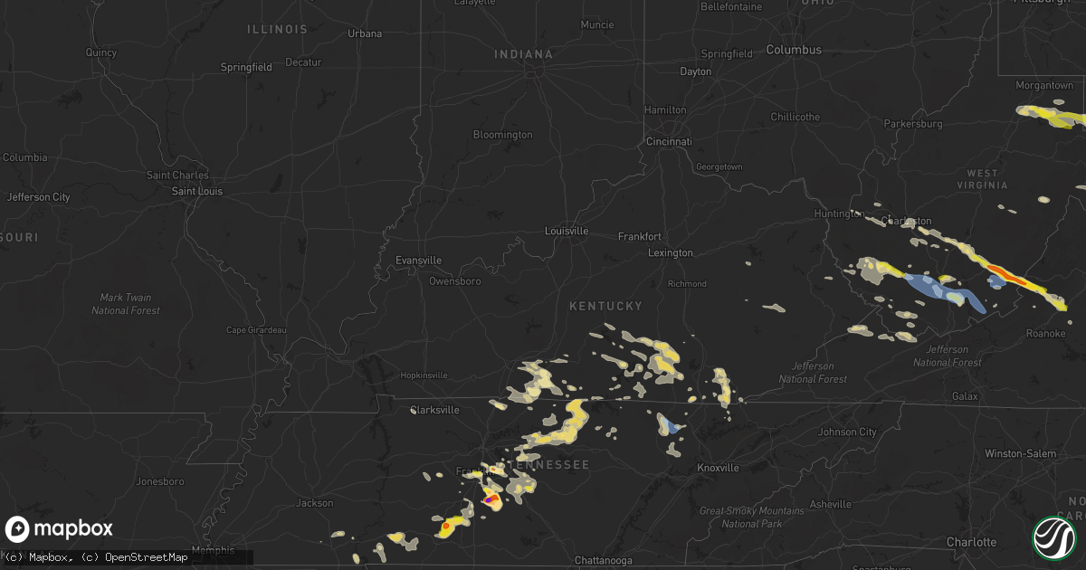
Hail Map in Kentucky on July 12, 2022
Get this storm
July 12 map
$229
one time, instant access
Download today. No call, no setup
Keep the $229
Bought the map and want the full workflow? Apply the entire $229 to a subscription within 7 days. None of it is wasted.
Every map, not just this one
This buys you this map. Subscription and you get every map we run, in the markets you choose from a few cities to whole states to nationwide. Plus real-time alerts the moment a storm fires.
Contact data
Name, contact info, occupancy, even credit band for addresses in the footprint. You go from where it hit to who to call.
Become the source they trust
Unlimited branding weather history reports on demand. You already have the documented answer ready for the property owner, and you are the one who showed up with it.
Property data and RoofTrace estimates
Pull up any address you have got, its value and the exact code rules for that jurisdiction, straight from One Click Code. Then RoofTrace estimates the squares, pitch, and roof value, priced the way you price.
Storm reports in Kentucky
Kentucky
| Date | Description |
|---|---|
| 07/12/20225:42 PM CDT | Pictures on social media show a large portion of a yard pine tree snapped off along west chester avenue in middlesboro. |
| 07/12/20225:42 PM CDT | Pictures on social media show a large tree blown across dorchester avenue near the west end school. Another large tree was snapped and leaning on power lines. |
| 07/12/20225:37 PM CDT | Pictures posted by wril show multiple trees and branches had fallen onto a home along 43rd street... Leading to extensive roof interior ceiling damage. |
| 07/12/20225:29 PM CDT | Tree blown down along little clear creek road near ky route 190. |
| 07/12/20225:22 PM CDT | Tree blown down along ky route 190 about 6 miles from u.s. Route 25e. |
| 07/12/20225:22 PM CDT | Tree blown down at 403 w. Tennessee ave. |
| 07/12/20225:22 PM CDT | Tree blown down at 110 east park avenue. |
| 07/12/20225:19 PM CDT | 911 call center reports that a tree was down on east appletree rd about .4 miles from the intersection with ky-1651. Time estimated from radar. |
| 07/12/20225:10 PM CDT | 911 call center reports that a tree was down near the intersection of ky-1651 and old us 27. Time estimated from radar. |
| 07/12/20225:10 PM CDT | 911 call center reports that a tree was down near mile marker4 on ky-90. Time estimated from radar. |
| 07/12/20225:10 PM CDT | 911 call center reports that a tree was down near pine knot middle school near the intersection of ky-2792 and us 27. Time estimated from radar. |
| 07/12/20225:10 PM CDT | 911 call center reports that a tree was down near mile marker 7 on ky-700. Time estimated from radar. |
| 07/12/20225:00 PM CDT | Trained spotter reports numerous trees down on property. |
| 07/12/20224:25 PM CDT | Reports of several trees down. Time estimated by radar. |
| 07/12/20223:59 PM CDT | Reports of several trees and powerlines down. Time estimated by radar. |
| 07/12/20223:30 PM CDT | Trees being removed from b. Bertram road. |
| 07/12/20223:28 PM CDT | Several trees down on power lines. |
| 07/12/20223:25 PM CDT | Public report relayed by wbko. Downed trees on a property along dripping springs church road near wisdom. |
| 07/12/20222:14 AM CDT | At 713 PM EDT, a severe thunderstorm was located near Helenwood, or near Oneida, moving east at 20 mph. HAZARD...60 mph wind gusts and nickel size hail. SOURCE...Radar indicated. IMPACT...Expect damage to roofs, siding, and trees. Locations impacted include... Oneida, Huntsville, Helenwood, Winfield, Ketchen, Honey Creek State Park, Norma, Elgin, Robbins and Slick Rock. |
| 07/12/20221:41 AM CDT | At 639 PM EDT, a severe thunderstorm was located near Harrogate, or 9 miles east of Middlesboro, moving southeast at 25 mph. HAZARD...60 mph wind gusts and quarter size hail. SOURCE...Radar indicated. IMPACT...Hail damage to vehicles is expected. Expect wind damage to roofs, siding, and trees. Locations impacted include... New Tazewell, Tazewell, Harrogate, Howard Quarter, Cumberland Gap, Ewing, Arthur, Powell River Preserve and Rose Hill. |
| 07/12/20221:16 AM CDT | At 615 PM EDT, a severe thunderstorm was located over Stearns, or over Whitley City, moving southeast at 20 mph. HAZARD...60 mph wind gusts and penny size hail. SOURCE...Radar indicated. IMPACT...Expect damage to roofs, siding, and trees. Locations impacted include... La Follette, Oneida, Jellico, Winfield, Elk Valley, Ketchen, Indian Mountain State Park, Clairfield, Fincastle and White Oak.This includes Interstate 75 in Tennessee between mile markers 143 and161. |
| 07/12/20221:11 AM CDT | At 611 PM EDT, a severe thunderstorm was located near Whitley City, moving east at 25 mph. HAZARD...60 mph wind gusts and quarter size hail. SOURCE...Radar indicated. IMPACT...Hail damage to vehicles is expected. Expect wind damage to roofs, siding, and trees. This severe thunderstorm will be near... Duckrun around 625 PM EDT. Bounty around 630 PM EDT.Other locations in the path of this severe thunderstorm includeJellico Creek, Bon and Emlyn. |
| 07/12/202212:17 AM CDT | At 516 PM EDT, a severe thunderstorm was located near Steubenville, or near Monticello, moving east at 25 mph. HAZARD...60 mph wind gusts and quarter size hail. SOURCE...Radar indicated. IMPACT...Hail damage to vehicles is expected. Expect wind damage to roofs, siding, and trees. This severe thunderstorm will be near... Monticello around 525 PM EDT. Steubenville around 530 PM EDT. Betsey around 535 PM EDT.Other locations in the path of this severe thunderstorm includeGregory, Delta and Denney. |
| 07/12/202212:11 AM CDT | At 511 PM EDT, a severe thunderstorm was located over Decoy, or 13 miles east of Jackson, moving east at 25 mph. HAZARD...60 mph wind gusts and quarter size hail. SOURCE...Radar indicated. IMPACT...Hail damage to vehicles is expected. Expect wind damage to roofs, siding, and trees. This severe thunderstorm will be near... Decoy around 515 PM EDT. Buck around 520 PM EDT. Elmrock around 530 PM EDT.Other locations in the path of this severe thunderstorm includeYellow Mountain, Handshoe and Bolyn. |
| 07/12/202212:06 AM CDT | At 506 PM EDT, a severe thunderstorm was located over Grade, or 8 miles southeast of Somerset, moving southeast at 30 mph. HAZARD...60 mph wind gusts and half dollar size hail. SOURCE...Radar indicated. IMPACT...Hail damage to vehicles is expected. Expect wind damage to roofs, siding, and trees. This severe thunderstorm will be near... Mount Victory around 515 PM EDT. Huxley around 525 PM EDT.Other locations in the path of this severe thunderstorm include BarkCamp, Grove and Youngs Creek. |
| 07/11/202211:43 PM CDT | At 443 PM EDT, a severe thunderstorm was located over Quicksand, or over Jackson, moving east at 25 mph. HAZARD...60 mph wind gusts and quarter size hail. SOURCE...Radar indicated. IMPACT...Hail damage to vehicles is expected. Expect wind damage to roofs, siding, and trees. This severe thunderstorm will be near... Wilstacy around 450 PM EDT. Sikes around 455 PM EDT.Other locations in the path of this severe thunderstorm includeNoble, Daisydell and Buck. |
| 07/11/202211:39 PM CDT | At 438 PM EDT, a severe thunderstorm was located over Shopville, or near Somerset, moving east at 35 mph. HAZARD...60 mph wind gusts and quarter size hail. SOURCE...Radar indicated. IMPACT...Hail damage to vehicles is expected. Expect wind damage to roofs, siding, and trees. This severe thunderstorm will be near... Dykes around 445 PM EDT. |
| 07/11/202211:28 PM CDT | At 428 PM EDT, a severe thunderstorm was located over Mariba, or near Frenchburg, moving east at 30 mph. HAZARD...60 mph wind gusts and quarter size hail. SOURCE...Radar indicated. IMPACT...Hail damage to vehicles is expected. Expect wind damage to roofs, siding, and trees. This severe thunderstorm will be near... Wellington around 435 PM EDT. Artville around 440 PM EDT. Omer around 445 PM EDT.Other locations in the path of this severe thunderstorm includeHenry, Licking River and West Liberty. |
| 07/11/202211:19 PM CDT | At 419 PM EDT, a severe thunderstorm was located near Magnum, or 10 miles southeast of Liberty, moving east at 25 mph. HAZARD...60 mph wind gusts and quarter size hail. SOURCE...Radar indicated. IMPACT...Hail damage to vehicles is expected. Expect wind damage to roofs, siding, and trees. This severe thunderstorm will be near... Hogue around 430 PM EDT.Other locations in the path of this severe thunderstorm includeScience Hill and Dabney. |
| 07/11/202210:56 PM CDT | At 356 PM CDT, a severe thunderstorm was located near Portland, or 13 miles northwest of Gallatin, moving southeast at 15 mph. HAZARD...60 mph wind gusts and nickel size hail. SOURCE...Radar indicated. IMPACT...Expect damage to roofs, siding, and trees. Locations impacted include... Gallatin, Westmoreland, Cross Plains, Portland, Mitchellville, Cottontown, Oak Grove and Black Jack. |
| 07/11/202210:48 PM CDT | At 347 PM EDT/247 PM CDT/, a severe thunderstorm was located 7 miles south of Campbellsville, moving east at 30 mph. HAZARD...60 mph wind gusts and nickel size hail. SOURCE...Radar indicated. IMPACT...Expect damage to roofs, siding, and trees. This severe thunderstorm will remain over mainly rural areas of south central Taylor and northeastern Adair Counties, including the following locations... Casey Creek, Knifley, Yuma, Burdick, Atchison, Neatsville, Romine, Purdy, Ella and Holmes. |
| 07/11/202210:48 PM CDT | At 348 PM CDT, a severe thunderstorm was located near Jamestown, moving east at 25 mph. HAZARD...60 mph wind gusts and penny size hail. SOURCE...Radar indicated. IMPACT...Expect damage to roofs, siding, and trees. This severe thunderstorm will be near... Jamestown around 400 PM CDT. |
| 07/11/202210:44 PM CDT | At 344 PM EDT, a severe thunderstorm was located near Liberty, moving east at 30 mph. HAZARD...60 mph wind gusts and penny size hail. SOURCE...Radar indicated. IMPACT...Expect damage to roofs, siding, and trees. This severe thunderstorm will be near... Liberty around 355 PM EDT. |
| 07/11/202210:16 PM CDT | At 315 PM CDT, a severe thunderstorm was located 9 miles southwest of Glasgow, moving southeast at 35 mph. HAZARD...60 mph wind gusts and quarter size hail. SOURCE...Radar indicated. IMPACT...Hail damage to vehicles is expected. Expect wind damage to roofs, siding, and trees. This severe thunderstorm will remain over mainly rural areas of northwestern Monroe, northeastern Allen, southern Barren and southwestern Metcalfe Counties, including the following locations... Dry Fork, Eighty Eight, Bristletown, Gum Tree, Lucas, Haywood, Sulphur Lick, Austin, Nobob and Tracy. |
All States Impacted by Hail Map on July 12, 2022
Cities Impacted by Hail Map on July 12, 2022
- Verndale, MN
- Aldrich, MN
- Staples, MN
- Pierz, MN
- Climax, NY
- Coxsackie, NY
- Deer River, MN
- Briggsdale, CO
- East Meredith, NY
- Treadwell, NY
- Delhi, NY
- New Raymer, CO
- Mathias, WV
- Drums, PA
- Mount Bethel, PA
- Columbia, NJ
- Kunkletown, PA
- Great Meadows, NJ
- Effort, PA
- Andover, NJ
- Portland, PA
- Freeland, PA
- Lake Harmony, PA
- Blairstown, NJ
- Brodheadsville, PA
- Stanhope, NJ
- Albrightsville, PA
- White Haven, PA
- Hazleton, PA
- Weatherly, PA
- Bangor, PA
- Stroudsburg, PA
- East Stroudsburg, PA
- Hackettstown, NJ
- Jim Thorpe, PA
- Saylorsburg, PA
- Hillman, MN
- Foley, MN
- Tracys Landing, MD
- Dunkirk, MD
- Upper Marlboro, MD
- Churchton, MD
- Deale, MD
- Lothian, MD
- Long Eddy, NY
- Hume, VA
- Markham, VA
- Marshall, VA
- Linden, VA
- Akeley, MN
- Walker, MN
- Shady Spring, WV
- Hinton, WV
- Hinton, VA
- Fulks Run, VA
- Singers Glen, VA
- Harrisonburg, VA
- Linville, VA
- Stuyvesant, NY
- Kinderhook, NY
- Danville, PA
- Millville, PA
- Muncy, PA
- Orangeville, PA
- Berwick, PA
- Turbotville, PA
- Watsontown, PA
- Bloomsburg, PA
- Shinnston, WV
- Bridgeport, WV
- Fairmont, WV
- Gormania, WV
- Terra Alta, WV
- Enterprise, WV
- Worthington, WV
- Eglon, WV
- Newburg, WV
- Moatsville, WV
- Oakland, MD
- Tunnelton, WV
- Independence, WV
- Parsons, WV
- Aurora, WV
- Rowlesburg, WV
- Thornton, WV
- Grafton, WV
- Flemington, WV
- Iaeger, WV
- Welch, WV
- Davy, WV
- Kimball, WV
- Chicopee, MA
- Monson, MA
- Hampden, MA
- Springfield, MA
- Indian Orchard, MA
- Southampton, MA
- Holyoke, MA
- Wilbraham, MA
- Wales, MA
- Ludlow, MA
- West Springfield, MA
- Westfield, MA
- Wardensville, WV
- Webster Springs, WV
- Elk Garden, WV
- Keyser, WV
- Lacrosse, WA
- Saint John, WA
- Endicott, WA
- Thornton, WA
- Colfax, WA
- Fayetteville, WV
- Lenore, WV
- Kermit, WV
- Pineville, KY
- Nunn, CO
- Beckley, WV
- Beaver, WV
- Eagle Bridge, NY
- North Bennington, VT
- Cambridge, NY
- Middletown, DE
- Wiggins, CO
- Fort Morgan, CO
- Carr, CO
- Simsbury, CT
- Tariffville, CT
- Bloomfield, CT
- Boonville, NY
- Woodgate, NY
- Forestport, NY
- Hawkins, WI
- Glen Flora, WI
- Stephens City, VA
- Middletown, VA
- Front Royal, VA
- Motley, MN
- Cushing, MN
- Browerville, MN
- Brandywine, WV
- Huntington, WV
- Ona, WV
- Barboursville, WV
- Sterling, CO
- Atwood, CO
- Akron, CO
- Merino, CO
- Medford, WI
- Merriman, NE
- Whitman, NE
- Pequot Lakes, MN
- Brainerd, MN
- Pine River, MN
- Nisswa, MN
- Baxter, MN
- Log Lane Village, CO
- Snyder, CO
- Hillrose, CO
- Brush, CO
- Athens, NY
- Catskill, NY
- Cheyenne, WY
- Glen White, WV
- Lester, WV
- Coal City, WV
- Princewick, WV
- Slab Fork, WV
- Crab Orchard, WV
- Josephine, WV
- Rhodell, WV
- Midway, WV
- Sophia, WV
- Cossayuna, NY
- Argyle, NY
- Schuylerville, NY
- Corinth, NY
- Manchester, VT
- Salem, NY
- Pawlet, VT
- Londonderry, VT
- Greenfield Center, NY
- Manchester Center, VT
- West Rupert, VT
- Arlington, VT
- Saratoga Springs, NY
- West Pawlet, VT
- Peru, VT
- Bondville, VT
- Fort Edward, NY
- Granville, NY
- Porter Corners, NY
- Shushan, NY
- Greenwich, NY
- Jamaica, VT
- Dorset, VT
- East Dorset, VT
- Gansevoort, NY
- East Arlington, VT
- Cody, NE
- Merrifield, MN
- Crosby, MN
- Crosslake, MN
- Lisco, NE
- Suncook, NH
- Goshen, NH
- Epsom, NH
- Lempster, NH
- Contoocook, NH
- Charlestown, NH
- Claremont, NH
- Bradford, NH
- Bow, NH
- Loudon, NH
- Washington, NH
- South Acworth, NH
- Chichester, NH
- Henniker, NH
- Concord, NH
- Newport, NH
- Hillsborough, NH
- Dunbarton, NH
- Acworth, NH
- Warner, NH
- Foster, RI
- Dayville, CT
- Chepachet, RI
- Danielson, CT
- East Killingly, CT
- North Scituate, RI
- Roscoe, NY
- Otis, CO
- Davenport, NY
- West Davenport, NY
- Oneonta, NY
- Davenport Center, NY
- Francestown, NH
- New Boston, NH
- Goffstown, NH
- Weare, NH
- Hooksett, NH
- Auburn, NH
- Manchester, NH
- Greenfield, NH
- Bedford, NH
- Bennington, NH
- Rileyville, VA
- Luray, VA
- Edinburg, VA
- Mount Jackson, VA
- Fort Valley, VA
- Ashford, CT
- Eastford, CT
- Tolland, CT
- Pomfret Center, CT
- Willington, CT
- North Clarendon, VT
- Rutland, VT
- Castleton, VT
- Cuttingsville, VT
- Center Rutland, VT
- Killington, VT
- Bomoseen, VT
- Chittenden, VT
- Florence, VT
- Proctor, VT
- West Rutland, VT
- Pittsford, VT
- Townshend, VT
- Keene, NH
- Sullivan, NH
- Walpole, NH
- Stoddard, NH
- Gilsum, NH
- Westminster, VT
- Alstead, NH
- Antrim, NH
- Marlow, NH
- Nelson, NH
- Chester, VT
- Putney, VT
- Newfane, VT
- Hancock, NH
- Big Indian, NY
- Phoenicia, NY
- Claryville, NY
- Bemidji, MN
- Gurley, NE
- Greenville Junction, ME
- Breeden, WV
- Livingston, TN
- Monticello, MN
- Maple Lake, MN
- Clearwater, MN
- Frederick, MD
- Union Bridge, MD
- Mount Airy, MD
- Jackson, KY
- Clayhole, KY
- Bethel Springs, TN
- Crown City, OH
- Franklin, WV
- Riverton, WV
- Circleville, WV
- Deer Trail, CO
- South Charleston, WV
- Saint Albans, WV
- Tornado, WV
- Michie, TN
- Counce, TN
- Savannah, TN
- Columbia, KY
- Russell Springs, KY
- Rock Creek, WV
- Glen Daniel, WV
- Williamsburg, KY
- Newtonville, NJ
- Mays Landing, NJ
- Denniston, KY
- Frenchburg, KY
- Lascassas, TN
- Woodbury, TN
- Readyville, TN
- Bell Buckle, TN
- Murfreesboro, TN
- Milton, TN
- Bradyville, TN
- Christiana, TN
- Boncarbo, CO
- Weston, CO
- Trinidad, CO
- Union, WV
- Lindside, WV
- Glens Fork, KY
- Jamestown, KY
- Tompkinsville, KY
- Mount Ida, AR
- Red Boiling Springs, TN
- Lafayette, TN
- Pleasant Shade, TN
- Riddleton, TN
- Dixon Springs, TN
- Corinth, MS
- Waynesboro, TN
- Westpoint, TN
- Iron City, TN
- Lawrenceburg, TN
- Collinwood, TN
- Bandy, VA
- North Tazewell, VA
- Jewell Ridge, VA
- Berwind, WV
- Squire, WV
- Little Rock, AR
- Paint Rock, TX
- Eden, TX
- Amarillo, TX
- Valley Spring, TX
- Wartburg, TN
- Oliver Springs, TN
- Great Falls, VA
- Sterling, VA
- Poolesville, MD
- Potomac, MD
- Romney, WV
- Shanks, WV
- Rio, WV
- Morgan City, LA
- Paron, AR
- Benton, AR
- Iliff, CO
- Gloversville, NY
- Franklin, TN
- Monticello, KY
- Corbin, KY
- Ferguson, KY
- Whitley City, KY
- Bethelridge, KY
- Bronston, KY
- Burnside, KY
- Nancy, KY
- Parkers Lake, KY
- Stearns, KY
- Science Hill, KY
- Somerset, KY
- Dunnville, KY
- Eubank, KY
- Liberty, KY
- Windsor, KY
- Chapmanville, WV
- Indian Head, MD
- Nanjemoy, MD
- Schriever, LA
- Cuero, TX
- Llano, TX
- Chantilly, VA
- Aldie, VA
- Woodrow, CO
- Hot Springs Village, AR
- Lonsdale, AR
- Warfordsburg, PA
- Chevy Chase, MD
- Takoma Park, MD
- College Park, MD
- Lanham, MD
- Hyattsville, MD
- Bowie, MD
- Glenn Dale, MD
- Washington, DC
- Greenbelt, MD
- Riverdale, MD
- Silver Spring, MD
- Beltsville, MD
- Chapel Hill, TN
- Ghent, WV
- Jumping Branch, WV
- Cool Ridge, WV
- Nimitz, WV
- Pipestem, WV
- Arrington, TN
- College Grove, TN
- Dequincy, LA
- Starks, LA
- Columbia, TN
- Big Rock, VA
- Grundy, VA
- Mason, TX
- Conway, AR
- Gauley Bridge, WV
- Asbury, WV
- Caldwell, WV
- Eagle Rock, VA
- Buchanan, VA
- Montgomery, WV
- White Sulphur Springs, WV
- Ronceverte, WV
- Pond Gap, WV
- Rainelle, WV
- Hico, WV
- Smoot, WV
- Lewisburg, WV
- Maxwelton, WV
- Belle, WV
- Hugheston, WV
- Fincastle, VA
- Ansted, WV
- Rupert, WV
- Victor, WV
- Blount, WV
- Charmco, WV
- Lookout, WV
- Quinwood, WV
- Williamsburg, WV
- Pratt, WV
- Mammoth, WV
- Cedar Grove, WV
- Lansing, WV
- Crawley, WV
- Danese, WV
- Covington, VA
- Nallen, WV
- Culleoka, TN
- Norman, AR
- Westminster, MD
- Manchester, MD
- Taneytown, MD
- Harts, WV
- Hurricane, WV
- Winfield, WV
- Unionville, TN
- Shelbyville, TN
- Lewisburg, TN
- Eagleville, TN
- Rockvale, TN
- Panhandle, TX
- Holland, KY
- Scottsville, KY
- Weimar, TX
- Austin, KY
- Glasgow, KY
- Fountain Run, KY
- Lucas, KY
- Walsenburg, CO
- Avondale, CO
- Meridianville, AL
- Alderson, WV
- Yorktown, TX
- West Coxsackie, NY
- Menard, TX
- Dyke, VA
- Stanardsville, VA
- Fort Scott, KS
- Adolphus, KY
- Herndon, VA
- Fairdale, WV
- Saxon, WV
- Bolt, WV
- Surveyor, WV
- Delaplane, VA
- Cottontown, TN
- Portland, TN
- Inez, KY
- Tomahawk, KY
- Debord, KY
- Pioneer, TN
- Livingston, KY
- East Bernstadt, KY
- Sherwood, AR
- Lebanon, TN
- Harrogate, TN
- Gray, KY
- Barbourville, KY
- Heidrick, KY
- McLean, VA
- Vienna, VA
- Reston, VA
- Oakpark, VA
- Ruckersville, VA
- Hood, VA
- Orange, VA
- Reva, VA
- Pratts, VA
- Gordonsville, VA
- Madison, VA
- Unionville, VA
- Locust Dale, VA
- Radiant, VA
- Haywood, VA
- Rapidan, VA
- Brightwood, VA
- Somerset, VA
- Aroda, VA
- Leon, VA
- Barboursville, VA
- Rochelle, VA
- Culpeper, VA
- Mayflower, AR
- Arlington, VA
- Delray, WV
- Augusta, WV
- Stafford, VA
- Fredericksburg, TX
- Doss, TX
- Herndon, WV
- Pineville, WV
- New Richmond, WV
- Saulsville, WV
- Cabot, AR
- Jacksonville, AR
- Vilonia, AR
- Romance, AR
- Mount Vernon, AR
- Boston, VA
- Sperryville, VA
- Thurmont, MD
- Emmitsburg, MD
- Sabillasville, MD
- Keymar, MD
- Rocky Ridge, MD
- Rocksprings, TX
- Smiths Grove, KY
- Bowling Green, KY
- Gamaliel, KY
- Oakland, KY
- Westmoreland, TN
- Park City, KY
- Franklin, KY
- Mount Juliet, TN
- Round Hill, VA
- Bluemont, VA
- Granville, TN
- Summertown, TN
- Lynnville, TN
- Ethridge, TN
- Pulaski, TN
- Mount Pleasant, TN
- Smyrna, TN
- Nolensville, TN
- Hancock, MD
- Annapolis, MD
- Crownsville, MD
- Arnold, MD
- Jessieville, AR
- Malvern, AR
- Fletcher, NC
- Etlan, VA
- Mercersburg, PA
- Greencastle, PA
- Denton, MD
- Harrington, DE
- Cordova, MD
- Greenwood, DE
- Greenbrier, AR
- Enola, AR
- Elk Horn, KY
- Campbellsville, KY
- Searcy, AR
- Pine Knot, KY
- Bedford, VA
- Thaxton, VA
- Albany, KY
- Burkesville, KY
- Caryville, TN
- The Plains, VA
- Ewing, VA
- Ozona, TX
- Adamsville, TN
- Valley Head, WV
- New Market, VA
- Quicksburg, VA
- Ashburn, VA
- Leesburg, VA
- Middleburg, VA
- Purcellville, VA
- Chatham, NY
- Maumelle, AR
- North Little Rock, AR
- Lindon, CO
- Anton, CO
- Miami, WV
- Eskdale, WV
- Winifrede, WV
- Hernshaw, WV
- Comfort, WV
- Drybranch, WV
- Hansford, WV
- Cabin Creek, WV
- Gallagher, WV
- Bivalve, MD
- Quantico, MD
- Vienna, MD
- Tyaskin, MD
- Eden, MD
- Nanticoke, MD
- Forest Hill, MD
- Monkton, MD
- Jarrettsville, MD
- Aberdeen, MD
- Bel Air, MD
- Fallston, MD
- Churchville, MD
- Calvin, KY
- Pecks Mill, WV
- Logan, WV
- Lake, WV
- Amherstdale, WV
- Yolyn, WV
- Gainesville, VA
- Warrenton, VA
- Nokesville, VA
- Bristow, VA
- Catharpin, VA
- Manassas, VA
- Haymarket, VA
- Broad Run, VA
- Greensburg, KY
- Grand Chenier, LA
- Fredericksburg, VA
- Cannon, KY
- Middlesboro, KY
- Flat Lick, KY
- Artemus, KY
- Frakes, KY
- Trosper, KY
- Bimble, KY
- Rockholds, KY
- Bryants Store, KY
- Whitewood, VA
- Oakwood, VA
- Raven, VA
- Pilgrims Knob, VA
- Hallettsville, TX
- Mertzon, TX
- Watertown, TN
- Buffalo Valley, TN
- Whitleyville, TN
- Alexandria, TN
- Gainesboro, TN
- Hilham, TN
- Carthage, TN
- Baxter, TN
- Celina, TN
- Chestnut Mound, TN
- Elmwood, TN
- Brush Creek, TN
- Moss, TN
- Bloomington Springs, TN
- Hestand, KY
- Gordonsville, TN
- Funkstown, MD
- Smithsburg, MD
- Myersville, MD
- Hagerstown, MD
- Thompsons Station, TN
- Chambersburg, PA
- Saint Thomas, PA
- North Spring, WV
- Ikes Fork, WV
- Brentwood, TN
- Fritch, TX
- Borger, TX
- Fairfax, VA
- Oakton, VA
- Oden, AR
- Houston, TX
- Fall River, KS
- Fredonia, KS
- Benedict, KS
- Comfort, TX
- Kerrville, TX
- Toms Brook, VA
- Burlington, WV
- Capon Bridge, WV
- High View, WV
- Yellow Spring, WV
- Purgitsville, WV
- Moorefield, WV
- Maurertown, VA
- Old Fields, WV
- New Creek, WV
- Gore, VA
- Baker, WV
- Byrdstown, TN
- Lahmansville, WV
- Strasburg, VA
- Boyce, VA
- Mount Storm, WV
- Winchester, VA
- Star Tannery, VA
- Berryville, VA
- Crawford, TN
- El Campo, TX
- Wharton, TX
- Knob Lick, KY
- Rickman, TN
- Monterey, TN
- Hunt, TX
- Lyles, TN
- Melvin, TX
- La Vergne, TN
- Broad Brook, CT
- Windsor Locks, CT
- West Suffield, CT
- East Granby, CT
- East Windsor, CT
- Enfield, CT
- Suffield, CT
- Mena, AR
- Hot Springs National Park, AR
- Yoakum, TX
- Southfield, MA
- East Hartland, CT
- Riverton, CT
- Sandisfield, MA
- Somers, CT
- Colebrook, CT
- Ellington, CT
- Granville, MA
- Barkhamsted, CT
- North Granby, CT
- Norfolk, CT
- Southwick, MA
- West Hartland, CT
- Granby, CT
- West Granby, CT
- Katy, TX
- Cypress, TX
- Miles, TX
- Houston, AR
- Bigelow, AR
- Windsor, CT
- Fairfield, PA
- Blue Ridge Summit, PA
- Waynesboro, PA
- Belcamp, MD
- Gettysburg, PA
- Earleville, MD
- Reisterstown, MD
- White Hall, MD
- Hampstead, MD
- Baldwin, MD
- Chesapeake City, MD
- State Line, PA
- Aberdeen Proving Ground, MD
- Sparks Glencoe, MD
- Cascade, MD
- Havre De Grace, MD
- Perryville, MD
- Upperco, MD
- Rouzerville, PA
- North East, MD
- Parkton, MD
- Perry Point, MD
- Elbert, WV
- Paynesville, WV
- Hanover, WV
- Brady, TX
- Sapello, NM
- Speedwell, TN
- Lake Charles, LA
- Hackberry, LA
- Cameron, LA
- Sulphur, LA
- Voca, TX
- Little Orleans, MD
- Artemas, PA
- Flintstone, MD
- Bim, WV
- Chauncey, WV
- Henlawson, WV
- Lyburn, WV
- Omar, WV
- Delbarton, WV
- Switzer, WV
- Holden, WV
- Wharton, WV
- Hewett, WV
- Dingess, WV
- Stollings, WV
- Woodstock, VA
- Milton, WV
- Sod, WV
- Culloden, WV
- Breaks, VA
- Haysi, VA
- Elkhorn City, KY
- Vansant, VA
- Auburntown, TN
- Powellton, WV
- Kimberly, WV
- Robson, WV
- Twilight, WV
- Gilbert, WV
- Baisden, WV
- Wharncliffe, WV
- Caddo Gap, AR
- Florissant, CO
- Orange, TX
- Crofton, MD
- Gambrills, MD
- Medina, TX
- Winsted, CT
- Sheffield, MA
- Monterey, MA
- Canaan, CT
- Great Barrington, MA
- Ashley Falls, MA
- South Windsor, CT
- Mill River, MA
- Northville, NY
- Caroga Lake, NY
- Franklin, VT
- West Stockbridge, MA
- Ghent, NY
- East Chatham, NY
- Austerlitz, NY
- Canaan, NY
- Lenox, MA
- Richmond, MA
- Valatie, NY
- Old Chatham, NY
- Pittsfield, MA
- Upperville, VA
- Reedsville, WV
- Kingwood, WV
- Centreville, VA
- Bergton, VA
- Broadway, VA
- Faulkner, MD
- Bel Alton, MD
- Quantico, VA
- Charlotte Hall, MD
- Welcome, MD
- Newburg, MD
- Port Tobacco, MD
- Mechanicsville, MD
- La Plata, MD
- Bedford, PA
- Clearville, PA
- Hyndman, PA
- Meyersdale, PA
- Williamsport, MD
- Big Pool, MD
- Berkeley Springs, WV
- Needmore, PA
- Big Cove Tannery, PA
- Clear Spring, MD
- Pangburn, AR
- Art, TX
- Pontotoc, TX
- Nunnelly, TN
- Centerville, TN
- Perryville, AR
- Florence, AL
- Waterloo, AL
- Cope, CO
- Buna, TX
- Davidsonville, MD
- Severna Park, MD
- Odenton, MD
- Swanton, MD
- Bloomington, MD
- Charleston, WV
- Kensington, MD
- Edgewater, MD
- Mount Rainier, MD
- Garrett Park, MD
- Gaithersburg, MD
- Paris, VA
- Brentwood, MD
- Laurel, MD
- Derwood, MD
- Boyds, MD
- Dunn Loring, VA
- Falls Church, VA
- Dickerson, MD
- Rockville, MD
- Glen Echo, MD
- Riva, MD
- Bethesda, MD
- Olney, MD
- Germantown, MD
- Cross Plains, TN
- Orlinda, TN
- Mount Hermon, KY
- Barton, MD
- Accident, MD
- Grantsville, MD
- McHenry, MD
- Westernport, MD
- Lonaconing, MD
- Gradyville, KY
- Fredonia, TX
- Rixeyville, VA
- Woodville, VA
- Castleton, VA
- Timberville, VA
- Syria, VA
- Los Alamos, NM
- Immokalee, FL
- New Castle, VA
- Huntsville, TN
- Oneida, TN
- Robbins, TN
- Helenwood, TN
- Sunbright, TN
- Olivehill, TN
- Lutts, TN
- Greenville, WV
- Letona, AR
- Catlett, VA
- Creole, LA
- Nitro, WV
- Little Rock Air Force Base, AR
- New Tazewell, TN
- Jamestown, TN
- Indian Mound, TN
- Woodlawn, TN
- Siler, KY
- Sinks Grove, WV
- Allred, TN
- Alpine, TN
- Roland, AR
- Edmonton, KY
- Beattyville, KY
- Iuka, MS
- San Angelo, TX
- Kaplan, LA
- Sonora, TX
- Junction, TX
- Jackman, ME
- Hamilton, VA
- Greenville, ME
- Oneida, WI
- Seymour, WI
- Green Bay, WI
- Victor, CO
- Weldona, CO
- Cabin John, MD
- White Post, VA
- Capitol Heights, MD
- Fort Myer, VA
- Bladensburg, MD
- Boonsboro, MD
- Port Penn, DE
- Rising Sun, MD
- Hedgesville, WV
- Elkton, MD
- Newark, DE
- Maugansville, MD
- Darlington, MD
- Bear, DE
- Warwick, MD
- Delaware City, DE
- Saint Georges, DE
- Woodsboro, MD
- Conowingo, MD
- Port Deposit, MD
- Finksburg, MD
- Abingdon, MD
- New Windsor, MD
- Freeland, MD
- Falling Waters, WV
- Street, MD
- Townsend, DE
- New Castle, DE
- Phoenix, MD
- Colora, MD
- Fairplay, MD
- Cecilton, MD
- Charlestown, MD
- Odessa, DE
- Ballard, WV
- Cyclone, WV
- Glen Fork, WV
- Wayside, WV
- Ravencliff, WV
- Arnett, WV
- Glen Rogers, WV
- Forest Hill, WV
- Naoma, WV
- Odd, WV
- Maben, WV
- Oceana, WV
- Flat Top, WV
- White Oak, WV
- Secondcreekx, WV
- Danby, VT
- Springfield, VT
- Northwood, NH
- Eliot, ME
- York, ME
- Nottingham, NH
- Barrington, NH
- Dover, NH
- South Berwick, ME
- Rollinsford, NH
- Madbury, NH
- Strafford, NH
- West Townshend, VT
- West Wardsboro, VT
- Stafford Springs, CT
- Brimfield, MA
- Palmer, MA
- Marion, PA
- Clothier, WV


