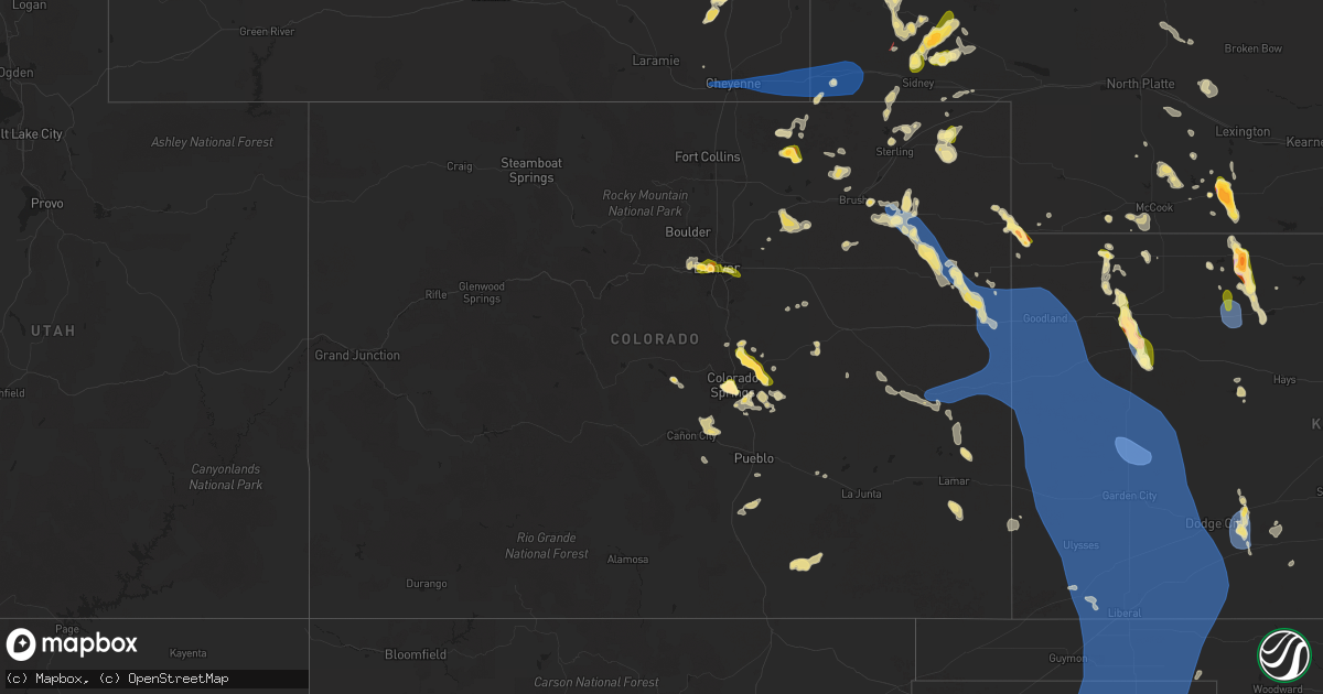
Hail Map in Colorado on July 6, 2025
Get this storm
July 6 map
$229
one time, instant access
Download today. No call, no setup
Keep the $229
Bought the map and want the full workflow? Apply the entire $229 to a subscription within 7 days. None of it is wasted.
Every map, not just this one
This buys you this map. Subscription and you get every map we run, in the markets you choose from a few cities to whole states to nationwide. Plus real-time alerts the moment a storm fires.
Contact data
Name, contact info, occupancy, even credit band for addresses in the footprint. You go from where it hit to who to call.
Become the source they trust
Unlimited branding weather history reports on demand. You already have the documented answer ready for the property owner, and you are the one who showed up with it.
Property data and RoofTrace estimates
Pull up any address you have got, its value and the exact code rules for that jurisdiction, straight from One Click Code. Then RoofTrace estimates the squares, pitch, and roof value, priced the way you price.
Storm reports in Colorado
Colorado
| Date | Description |
|---|---|
| 07/06/20256:56 PM CDT | Report from mping: quarter |
| 07/06/20256:51 PM CDT | Report from mping: half dollar |
| 07/06/20256:50 PM CDT | Report from mping: quarter |
| 07/06/20256:50 PM CDT | A local report indicates 1.40 inch wind near Black Forest |
| 07/06/20256:43 PM CDT | A local report indicates 2.00 inch wind near 2 SW Colorado Springs |
| 07/06/20256:40 PM CDT | Report from mping: quarter |
| 07/06/20256:35 PM CDT | A local report indicates 1.50 inch wind near 3 SE Manitou Springs |
| 07/06/20256:34 PM CDT | Report from mping: half dollar |
| 07/06/20256:30 PM CDT | A local report indicates 1.75 inch wind near 3 SE Manitou Springs |
| 07/06/20256:28 PM CDT | Report from mping: quarter |
| 07/06/20256:20 PM CDT | Storm lasted for 40 minutes |
| 07/06/20256:13 PM CDT | Report from mping: half dollar |
| 07/06/20256:07 PM CDT | A local report indicates 1.00 inch wind near 1 SW Colorado Springs |
| 07/06/20256:06 PM CDT | A local report indicates 1.00 inch wind near 1 SE Manitou Springs |
| 07/06/20256:05 PM CDT | A local report indicates 1.00 inch wind near 6 E Monument |
| 07/06/20255:54 PM CDT | Report from mping: ping pong ball |
| 07/06/20254:48 PM CDT | Location estimated. Multiple reports from spotters and chasers with video showing a landspout tornado lasting 5 min in duration. |
| 07/06/20254:40 PM CDT | A local report indicates 1.00 inch wind near 5 N Dailey |
| 07/05/202510:06 PM CDT | Kitr measured 67 mph wind gust. |
| 07/05/20259:29 PM CDT | Mesonet station up729 0.5 w kit carson |
| 07/05/20259:20 PM CDT | Mesonet station krk01 3 e joes 2. |
| 07/05/20258:16 PM CDT | A local report indicates 1.00 inch wind near 1 WNW Aurora |
| 07/05/20257:58 PM CDT | A local report indicates 1.00 inch wind near 4 E Denver |
| 07/05/20257:46 PM CDT | Report from mping: ping pong ball |
| 07/05/20257:39 PM CDT | Awos station kako akron. |
| 07/05/20257:31 PM CDT | Report from mping: quarter |
| 07/05/20257:11 PM CDT | A local report indicates 1.50 inch wind near Falcon |
| 07/05/20257:10 PM CDT | A local report indicates 1.00 inch wind near 3 N Falcon |
| 07/05/20257:07 PM CDT | Report from mping: quarter |
| 07/05/20257:03 PM CDT | A local report indicates 1.00 inch wind near 4 S Colorado Springs |
| 07/05/20257:00 PM CDT | Measured 1.5 inch hail. Widespread window damage and broken skylights reported. Hail fell for approximately 40 consecutive minutes. |
All States Impacted by Hail Map on July 6, 2025
Cities Impacted by Hail Map on July 6, 2025
- Kit Carson, CO
- Eads, CO
- Cheyenne Wells, CO
- Sheridan Lake, CO
- Arapahoe, CO
- Burlington, CO
- Bethune, CO
- Idalia, CO
- Kanorado, KS
- Saint Francis, KS
- Weskan, KS
- Sharon Springs, KS
- Goodland, KS
- Tribune, KS
- Martin, SD
- Wounded Knee, SD
- Batesland, SD
- Pine Ridge, SD
- Gordon, NE
- Allen, SD
- Merriman, NE
- Tuthill, SD
- Cody, NE
- Nenzel, NE
- Kilgore, NE
- Valentine, NE
- Crookston, NE
- Purdum, NE
- Brewster, NE
- Hammond, LA
- Stapleton, NE
- Ponchatoula, LA
- Arnold, NE
- Scotia, NE
- Gothenburg, NE
- Gonzales, LA
- Advance, MO
- Whitewater, MO
- Maxwell, NE
- Greeley, NE
- Chaffee, MO
- Spalding, NE
- Primrose, NE
- Cedar Rapids, NE
- Brady, NE
- Donaldsonville, LA
- Farnam, NE
- Callaway, NE
- Cozad, NE
- Geismar, LA
- Darrow, LA
- Prairieville, LA
- Belgrade, NE
- White Castle, LA
- Albion, NE
- Troy, MO
- Saint Edward, NE
- Parma, MO
- Eureka, KS
- Fortuna, MO
- Tipton, MO
- Versailles, MO
- Fullerton, NE
- Eustis, NE
- Richards, MO
- Modoc, IL
- Evansville, IL
- Genoa, NE
- Franklinton, LA
- Catron, MO
- Belle Rose, LA
- Arapahoe, NE
- Wolbach, NE
- Silver Creek, NE
- Monroe, NE
- Deer Trail, CO
- Edgewood, NM
- Holbrook, NE
- Curtis, NE
- Elwood, NE
- Clarks, NE
- Sandia Park, NM
- Cedar Crest, NM
- Deerfield, MO
- Nevada, MO
- Maywood, NE
- Madison, KS
- Pierre Part, LA
- Hamilton, KS
- Edison, NE
- Agate, CO
- Tijeras, NM
- Hayes Center, NE
- Bronson, KS
- Columbus, NE
- Saint Martinville, LA
- Kenner, LA
- Eldorado, TX
- Montezuma, NM
- Stockville, NE
- East Saint Louis, IL
- Madison, IL
- Moundville, MO
- Cambridge, NE
- Cheyenne, WY
- Beaver City, NE
- New Iberia, LA
- Moran, KS
- Ozona, TX
- Moorefield, NE
- San Jose, NM
- Metairie, LA
- Wilsonville, NE
- Hendley, NE
- Collinsville, IL
- Woodrow, CO
- Wardell, MO
- Hayti, MO
- Bragg City, MO
- Chugwater, WY
- Portageville, MO
- Sedalia, MO
- Benton, KS
- Wichita, KS
- Saint Louis, MO
- Bartley, NE
- Indianola, NE
- McCook, NE
- Smithton, MO
- El Dorado, KS
- Scott, LA
- Lafayette, LA
- Burns, KS
- Granite City, IL
- Venice, IL
- Lovejoy, IL
- Fe Warren Afb, WY
- Trenton, NE
- Culbertson, NE
- Pontotoc, MS
- Marine, IL
- Saint Jacob, IL
- Norton, KS
- Lebanon, IL
- Monticello, AR
- Andover, KS
- Des Moines, NM
- Capulin, NM
- Duson, LA
- Vancourt, TX
- Fort Scott, KS
- Knob Noster, MO
- Alamogordo, NM
- Haxtun, CO
- Fleming, CO
- Millstadt, IL
- Belleville, IL
- Brainard, NE
- Ribera, NM
- Lenora, KS
- Almena, KS
- Christoval, TX
- Edwardsville, IL
- O'Fallon, IL
- Fairview Heights, IL
- Sedgwick, CO
- Ponderosa, NM
- Akron, CO
- Stewardson, IL
- Herrick, IL
- Shelbyville, IL
- Strasburg, IL
- La Monte, MO
- Green Ridge, MO
- Lakewood, IL
- Tower Hill, IL
- Cowden, IL
- Logan, KS
- Atwood, KS
- Louisiana, MO
- Garland, KS
- Oberlin, KS
- Herndon, KS
- Derby, KS
- Raton, NM
- Windsor, MO
- Waynesville, MO
- Murdock, KS
- Mebane, NC
- Leon, KS
- Coffeen, IL
- Greenville, IL
- Donnellson, IL
- Ozark, MO
- Alva, OK
- Iraan, TX
- Rogersville, MO
- Fillmore, IL
- Bogue, KS
- Douglass, KS
- Mulvane, KS
- Fountain Hill, AR
- Wilmar, AR
- Hermitage, AR
- Clearwater, KS
- Arcadia, KS
- Larkspur, CO
- Witt, IL
- Ramsey, IL
- Neoga, IL
- Windsor, IL
- Briggsdale, CO
- Grover, CO
- Hamburg, AR
- Elbert, CO
- Pine Bluffs, WY
- Hillsdale, WY
- Carpenter, WY
- Burns, WY
- Valley Center, KS
- Wheatland, WY
- Bingham, IL
- Kingman, KS
- Steelville, MO
- Belle Plaine, KS
- Cunningham, KS
- Bushnell, NE
- Colorado Springs, CO
- Norwich, KS
- Milton, KS
- Colby, KS
- Rapid City, SD
- Sedgwick, KS
- Moriarty, NM
- Encino, NM
- Carmen, OK
- Beecher City, IL
- Altamont, IL
- Guernsey, WY
- Monument, CO
- Manitou Springs, CO
- Benedict, KS
- Sterling, CO
- Dacoma, OK
- Aline, OK
- Glendo, WY
- Lucedale, MS
- Charlotte, TX
- Stockton, KS
- Harper, KS
- Argonia, KS
- Spivey, KS
- Manville, WY
- Gem, KS
- Fort Morgan, CO
- Wray, CO
- Scott Air Force Base, IL
- Effingham, IL
- Crook, CO
- Peck, KS
- Model, CO
- Wellington, KS
- Hermosa, SD
- Peyton, CO
- Hartville, WY
- Clayton, NM
- Fort Hancock, TX
- Torrington, WY
- Jay Em, WY
- Damar, KS
- Iliff, CO
- Gurley, NE
- Chappell, NE
- Chester, OK
- Lodgepole, NE
- Oakley, KS
- Dalton, NE
- Kechi, KS
- Peetz, CO
- Buffalo, KS
- Gillette, WY
- Fountain, CO
- Waynoka, OK
- Matheson, CO
- Breaux Bridge, LA
- Lusk, WY
- Snyder, CO
- New Raymer, CO
- Youngsville, LA
- Broussard, LA
- Sunset, LA
- Carencro, LA
- Rexford, KS
- Mode, IL
- Roggen, CO
- Sidney, NE
- Bayard, NE
- Rock, KS
- Udall, KS
- Simla, CO
- Bunker, MO
- Stonington, IL
- Fairview, OK
- Grinnell, KS
- Altoona, KS
- Sawyer, KS
- Haigler, NE
- Bridgeport, NE
- Golden, CO
- Broadwater, NE
- Wakeeney, KS
- Ellis, KS
- Ogallah, KS
- Mutual, OK
- Denver, CO
- Fairburn, SD
- Coats, KS
- Leesville, LA
- Lena, LA
- Bunkie, LA
- Lance Creek, WY
- Bluff City, KS
- Angora, NE
- Prairie Du Rocher, IL
- Anthony, KS
- Boyce, LA
- Otis, CO
- Keenesburg, CO
- Lisco, NE
- Rye, CO
- Walsenburg, CO
- Avondale, CO
- Mosquero, NM
- Springfield, MO
- Aurora, CO
- Oswego, KS
- Wiggins, CO
- Arvada, CO
- Wheat Ridge, CO
- Spearville, KS
- Hanston, KS
- Haviland, KS
- Helena, OK
- Padroni, CO
- Seiling, OK
- Bennett, CO
- Hugo, CO
- Ramah, CO
- Alliance, NE
- Hulett, WY
- Moorcroft, WY
- Weston, WY
- Wright, KS
- Florissant, CO
- Kimball, NE
- Corona, NM
- Parks, NE
- Manchester, OK
- Amorita, OK
- Waldron, KS
- Kinsley, KS
- Ford, KS
- Ellsworth, NE
- Cope, CO
- Yancey, TX
- D Hanis, TX
- Dodge City, KS
- Greensburg, KS
- Guffey, CO
- Joes, CO
- Hemingford, NE
- Yuma, CO
- Newcastle, WY
- Kirk, CO
- Tucumcari, NM
- Manzanola, CO
- Karval, CO
- Alzada, MT
- Potter, NE
- Shawnee, WY
- Oshkosh, NE
- Stratton, CO
- Olney Springs, CO
- Cascade, CO
- Jetmore, KS
- Farmerville, LA
- Florence, CO
- Wetmore, CO
- Broadus, MT
- Bingham, NE
- Kiowa, KS
- Anton Chico, NM
- Cheney, KS
- Lakeside, NE
- Osage, WY
- Edson, KS
- Brewster, KS
- Calhan, CO
- Bucklin, KS
- Wallace, KS
- Penrose, CO
- Lilbourn, MO
- Lead, SD
- Hill City, SD
- Yoder, CO
- El Dorado, AR
- Canon City, CO
- Westby, MT
- Winona, KS
- Leoti, KS
- Pratt, KS
- Laverne, OK
- Shattuck, OK
- Gage, OK
- Deerfield, KS
- Lakin, KS
- Marienthal, KS
- Scott City, KS
- Arnett, OK
- Holcomb, KS
- Lamar, CO
- Sundance, WY
- Garden City, KS
- Healy, KS
- Upton, WY
- Holly, CO
- Syracuse, KS
- Bronaugh, MO
- Milo, MO
- Sheldon, MO
- Marshfield, MO
- Strafford, MO
- Canadian, TX
- Manter, KS
- Durham, OK
- Reydon, OK
- Cimarron, KS
- Dighton, KS
- Two Buttes, CO
- Walsh, CO
- Granada, CO
- Mcconnell Afb, KS
- Danville, KS
- Freeport, KS
- Caldwell, KS
- Milan, KS
- South Haven, KS
- Geuda Springs, KS
- Braman, OK
- Nardin, OK
- Medford, OK
- Blackwell, OK
- Deer Creek, OK
- Hugoton, KS
- Wheeler, TX
- Mobeetie, TX
- Briscoe, TX
- Shamrock, TX
- Rozet, WY
- Devils Tower, WY
- Keystone, SD
- Hill City, KS
- Benkelman, NE
- Wellfleet, NE
- Clarendon, TX
- Lelia Lake, TX
- Hedley, TX
- Faith, SD
- Wasta, SD
- Ord, NE
- Ericson, NE
- Hay Springs, NE
- Stratton, NE
- Dix, NE
- Penokee, KS
- Hoxie, KS
- Pierceville, KS
- Ulysses, KS
- Kendall, KS
- Johnson, KS
- Satanta, KS
- Hooker, OK
- Moscow, KS
- Sublette, KS
- Montezuma, KS
- Tyrone, OK
- Englewood, KS
- Plains, KS
- Turpin, OK
- Fowler, KS
- Copeland, KS
- Liberal, KS
- Ensign, KS
- Ingalls, KS
- Minneola, KS
- Meade, KS
- Kismet, KS
- Forgan, OK
- Guymon, OK
- Hardesty, OK
- Gate, OK
- Beaver, OK
- Balko, OK
- Gruver, TX
- Spearman, TX
- Perryton, TX
- Booker, TX
- Morse, TX
- Stinnett, TX
- Borger, TX
- Claude, TX
- Miami, TX
- Pampa, TX
- Skellytown, TX
- Panhandle, TX
- Fritch, TX
- Mclean, TX
- Follett, TX
- White Deer, TX
- Higgins, TX
- Darrouzett, TX
- Lipscomb, TX
- Groom, TX
- Quitaque, TX
- Lakeview, TX
- Quail, TX
- Memphis, TX
- California, MO
- Clarksburg, MO
- Centertown, MO
- Lohman, MO
- Jefferson City, MO


