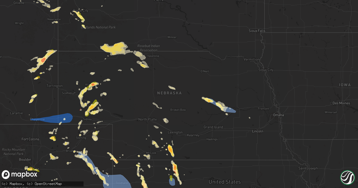
Hail Map in Nebraska on July 6, 2025
Get this storm
July 6 map
$229
one time, instant access
Download today. No call, no setup
Keep the $229
Bought the map and want the full workflow? Apply the entire $229 to a subscription within 7 days. None of it is wasted.
Every map, not just this one
This buys you this map. Subscription and you get every map we run, in the markets you choose from a few cities to whole states to nationwide. Plus real-time alerts the moment a storm fires.
Contact data
Name, contact info, occupancy, even credit band for addresses in the footprint. You go from where it hit to who to call.
Become the source they trust
Unlimited branding weather history reports on demand. You already have the documented answer ready for the property owner, and you are the one who showed up with it.
Property data and RoofTrace estimates
Pull up any address you have got, its value and the exact code rules for that jurisdiction, straight from One Click Code. Then RoofTrace estimates the squares, pitch, and roof value, priced the way you price.
Storm reports in Nebraska
Nebraska
| Date | Description |
|---|---|
| 07/06/20256:53 PM CDT | Upr site near brownson gusted 58 mph during a thunderstorm. |
| 07/06/20253:43 PM CDT | A local report indicates 1.50 inch wind near 2 E Beaver City |
| 07/06/20253:28 PM CDT | Ping pong ball to golf ball size hail reported. Hail covering the road. Visibility near zero due to heavy rain. |
| 07/06/20253:10 PM CDT | Reports from this spotter between holbrook of hail between golf ball and baseball size hail and wind gusts of 60 to 65 mph. First report of large hail was approx 305pm. |
| 07/06/20252:19 PM CDT | Measured gust from public mesonet station. |
| 07/06/20252:17 PM CDT | Personal weather station reports gust to 69mph. |
| 07/05/20259:01 PM CDT | Report from mping: ping pong ball |
| 07/05/20258:55 PM CDT | Report from mping: half dollar |
| 07/05/20258:50 PM CDT | Golf ball to baseball size hail broke several windows. Time estimated from radar. |
| 07/05/20258:38 PM CDT | Report from mping: quarter |
| 07/05/20258:12 PM CDT | Trained spotter reports half dollar size hail. |
| 07/05/20258:03 PM CDT | Report from mping: quarter |
| 07/05/20257:57 PM CDT | Trained spotter reports quarter size hail. |
| 07/05/20257:57 PM CDT | Trained spotter reports crop damage due to wind and a 6 inch diameter tree blown over. |
| 07/05/20257:49 PM CDT | Report from mping: golf ball |
| 07/05/20257:44 PM CDT | Trained spot |
| 07/05/20257:44 PM CDT | Trained spotter reports hail ranging from 1 to 1.5 inches in size. |
| 07/05/20257:35 PM CDT | Trained spotter reports golf ball size hail. |
| 07/05/20257:12 PM CDT | [landspout] videos from social media showing landspout ground circulation. Time estimated from radar. |
All States Impacted by Hail Map on July 6, 2025
Cities Impacted by Hail Map on July 6, 2025
- Kit Carson, CO
- Eads, CO
- Cheyenne Wells, CO
- Sheridan Lake, CO
- Arapahoe, CO
- Burlington, CO
- Bethune, CO
- Idalia, CO
- Kanorado, KS
- Saint Francis, KS
- Weskan, KS
- Sharon Springs, KS
- Goodland, KS
- Tribune, KS
- Martin, SD
- Wounded Knee, SD
- Batesland, SD
- Pine Ridge, SD
- Gordon, NE
- Allen, SD
- Merriman, NE
- Tuthill, SD
- Cody, NE
- Nenzel, NE
- Kilgore, NE
- Valentine, NE
- Crookston, NE
- Purdum, NE
- Brewster, NE
- Hammond, LA
- Stapleton, NE
- Ponchatoula, LA
- Arnold, NE
- Scotia, NE
- Gothenburg, NE
- Gonzales, LA
- Advance, MO
- Whitewater, MO
- Maxwell, NE
- Greeley, NE
- Chaffee, MO
- Spalding, NE
- Primrose, NE
- Cedar Rapids, NE
- Brady, NE
- Donaldsonville, LA
- Farnam, NE
- Callaway, NE
- Cozad, NE
- Geismar, LA
- Darrow, LA
- Prairieville, LA
- Belgrade, NE
- White Castle, LA
- Albion, NE
- Troy, MO
- Saint Edward, NE
- Parma, MO
- Eureka, KS
- Fortuna, MO
- Tipton, MO
- Versailles, MO
- Fullerton, NE
- Eustis, NE
- Richards, MO
- Modoc, IL
- Evansville, IL
- Genoa, NE
- Franklinton, LA
- Catron, MO
- Belle Rose, LA
- Arapahoe, NE
- Wolbach, NE
- Silver Creek, NE
- Monroe, NE
- Deer Trail, CO
- Edgewood, NM
- Holbrook, NE
- Curtis, NE
- Elwood, NE
- Clarks, NE
- Sandia Park, NM
- Cedar Crest, NM
- Deerfield, MO
- Nevada, MO
- Maywood, NE
- Madison, KS
- Pierre Part, LA
- Hamilton, KS
- Edison, NE
- Agate, CO
- Tijeras, NM
- Hayes Center, NE
- Bronson, KS
- Columbus, NE
- Saint Martinville, LA
- Kenner, LA
- Eldorado, TX
- Montezuma, NM
- Stockville, NE
- East Saint Louis, IL
- Madison, IL
- Moundville, MO
- Cambridge, NE
- Cheyenne, WY
- Beaver City, NE
- New Iberia, LA
- Moran, KS
- Ozona, TX
- Moorefield, NE
- San Jose, NM
- Metairie, LA
- Wilsonville, NE
- Hendley, NE
- Collinsville, IL
- Woodrow, CO
- Wardell, MO
- Hayti, MO
- Bragg City, MO
- Chugwater, WY
- Portageville, MO
- Sedalia, MO
- Benton, KS
- Wichita, KS
- Saint Louis, MO
- Bartley, NE
- Indianola, NE
- McCook, NE
- Smithton, MO
- El Dorado, KS
- Scott, LA
- Lafayette, LA
- Burns, KS
- Granite City, IL
- Venice, IL
- Lovejoy, IL
- Fe Warren Afb, WY
- Trenton, NE
- Culbertson, NE
- Pontotoc, MS
- Marine, IL
- Saint Jacob, IL
- Norton, KS
- Lebanon, IL
- Monticello, AR
- Andover, KS
- Des Moines, NM
- Capulin, NM
- Duson, LA
- Vancourt, TX
- Fort Scott, KS
- Knob Noster, MO
- Alamogordo, NM
- Haxtun, CO
- Fleming, CO
- Millstadt, IL
- Belleville, IL
- Brainard, NE
- Ribera, NM
- Lenora, KS
- Almena, KS
- Christoval, TX
- Edwardsville, IL
- O'Fallon, IL
- Fairview Heights, IL
- Sedgwick, CO
- Ponderosa, NM
- Akron, CO
- Stewardson, IL
- Herrick, IL
- Shelbyville, IL
- Strasburg, IL
- La Monte, MO
- Green Ridge, MO
- Lakewood, IL
- Tower Hill, IL
- Cowden, IL
- Logan, KS
- Atwood, KS
- Louisiana, MO
- Garland, KS
- Oberlin, KS
- Herndon, KS
- Derby, KS
- Raton, NM
- Windsor, MO
- Waynesville, MO
- Murdock, KS
- Mebane, NC
- Leon, KS
- Coffeen, IL
- Greenville, IL
- Donnellson, IL
- Ozark, MO
- Alva, OK
- Iraan, TX
- Rogersville, MO
- Fillmore, IL
- Bogue, KS
- Douglass, KS
- Mulvane, KS
- Fountain Hill, AR
- Wilmar, AR
- Hermitage, AR
- Clearwater, KS
- Arcadia, KS
- Larkspur, CO
- Witt, IL
- Ramsey, IL
- Neoga, IL
- Windsor, IL
- Briggsdale, CO
- Grover, CO
- Hamburg, AR
- Elbert, CO
- Pine Bluffs, WY
- Hillsdale, WY
- Carpenter, WY
- Burns, WY
- Valley Center, KS
- Wheatland, WY
- Bingham, IL
- Kingman, KS
- Steelville, MO
- Belle Plaine, KS
- Cunningham, KS
- Bushnell, NE
- Colorado Springs, CO
- Norwich, KS
- Milton, KS
- Colby, KS
- Rapid City, SD
- Sedgwick, KS
- Moriarty, NM
- Encino, NM
- Carmen, OK
- Beecher City, IL
- Altamont, IL
- Guernsey, WY
- Monument, CO
- Manitou Springs, CO
- Benedict, KS
- Sterling, CO
- Dacoma, OK
- Aline, OK
- Glendo, WY
- Lucedale, MS
- Charlotte, TX
- Stockton, KS
- Harper, KS
- Argonia, KS
- Spivey, KS
- Manville, WY
- Gem, KS
- Fort Morgan, CO
- Wray, CO
- Scott Air Force Base, IL
- Effingham, IL
- Crook, CO
- Peck, KS
- Model, CO
- Wellington, KS
- Hermosa, SD
- Peyton, CO
- Hartville, WY
- Clayton, NM
- Fort Hancock, TX
- Torrington, WY
- Jay Em, WY
- Damar, KS
- Iliff, CO
- Gurley, NE
- Chappell, NE
- Chester, OK
- Lodgepole, NE
- Oakley, KS
- Dalton, NE
- Kechi, KS
- Peetz, CO
- Buffalo, KS
- Gillette, WY
- Fountain, CO
- Waynoka, OK
- Matheson, CO
- Breaux Bridge, LA
- Lusk, WY
- Snyder, CO
- New Raymer, CO
- Youngsville, LA
- Broussard, LA
- Sunset, LA
- Carencro, LA
- Rexford, KS
- Mode, IL
- Roggen, CO
- Sidney, NE
- Bayard, NE
- Rock, KS
- Udall, KS
- Simla, CO
- Bunker, MO
- Stonington, IL
- Fairview, OK
- Grinnell, KS
- Altoona, KS
- Sawyer, KS
- Haigler, NE
- Bridgeport, NE
- Golden, CO
- Broadwater, NE
- Wakeeney, KS
- Ellis, KS
- Ogallah, KS
- Mutual, OK
- Denver, CO
- Fairburn, SD
- Coats, KS
- Leesville, LA
- Lena, LA
- Bunkie, LA
- Lance Creek, WY
- Bluff City, KS
- Angora, NE
- Prairie Du Rocher, IL
- Anthony, KS
- Boyce, LA
- Otis, CO
- Keenesburg, CO
- Lisco, NE
- Rye, CO
- Walsenburg, CO
- Avondale, CO
- Mosquero, NM
- Springfield, MO
- Aurora, CO
- Oswego, KS
- Wiggins, CO
- Arvada, CO
- Wheat Ridge, CO
- Spearville, KS
- Hanston, KS
- Haviland, KS
- Helena, OK
- Padroni, CO
- Seiling, OK
- Bennett, CO
- Hugo, CO
- Ramah, CO
- Alliance, NE
- Hulett, WY
- Moorcroft, WY
- Weston, WY
- Wright, KS
- Florissant, CO
- Kimball, NE
- Corona, NM
- Parks, NE
- Manchester, OK
- Amorita, OK
- Waldron, KS
- Kinsley, KS
- Ford, KS
- Ellsworth, NE
- Cope, CO
- Yancey, TX
- D Hanis, TX
- Dodge City, KS
- Greensburg, KS
- Guffey, CO
- Joes, CO
- Hemingford, NE
- Yuma, CO
- Newcastle, WY
- Kirk, CO
- Tucumcari, NM
- Manzanola, CO
- Karval, CO
- Alzada, MT
- Potter, NE
- Shawnee, WY
- Oshkosh, NE
- Stratton, CO
- Olney Springs, CO
- Cascade, CO
- Jetmore, KS
- Farmerville, LA
- Florence, CO
- Wetmore, CO
- Broadus, MT
- Bingham, NE
- Kiowa, KS
- Anton Chico, NM
- Cheney, KS
- Lakeside, NE
- Osage, WY
- Edson, KS
- Brewster, KS
- Calhan, CO
- Bucklin, KS
- Wallace, KS
- Penrose, CO
- Lilbourn, MO
- Lead, SD
- Hill City, SD
- Yoder, CO
- El Dorado, AR
- Canon City, CO
- Westby, MT
- Winona, KS
- Leoti, KS
- Pratt, KS
- Laverne, OK
- Shattuck, OK
- Gage, OK
- Deerfield, KS
- Lakin, KS
- Marienthal, KS
- Scott City, KS
- Arnett, OK
- Holcomb, KS
- Lamar, CO
- Sundance, WY
- Garden City, KS
- Healy, KS
- Upton, WY
- Holly, CO
- Syracuse, KS
- Bronaugh, MO
- Milo, MO
- Sheldon, MO
- Marshfield, MO
- Strafford, MO
- Canadian, TX
- Manter, KS
- Durham, OK
- Reydon, OK
- Cimarron, KS
- Dighton, KS
- Two Buttes, CO
- Walsh, CO
- Granada, CO
- Mcconnell Afb, KS
- Danville, KS
- Freeport, KS
- Caldwell, KS
- Milan, KS
- South Haven, KS
- Geuda Springs, KS
- Braman, OK
- Nardin, OK
- Medford, OK
- Blackwell, OK
- Deer Creek, OK
- Hugoton, KS
- Wheeler, TX
- Mobeetie, TX
- Briscoe, TX
- Shamrock, TX
- Rozet, WY
- Devils Tower, WY
- Keystone, SD
- Hill City, KS
- Benkelman, NE
- Wellfleet, NE
- Clarendon, TX
- Lelia Lake, TX
- Hedley, TX
- Faith, SD
- Wasta, SD
- Ord, NE
- Ericson, NE
- Hay Springs, NE
- Stratton, NE
- Dix, NE
- Penokee, KS
- Hoxie, KS
- Pierceville, KS
- Ulysses, KS
- Kendall, KS
- Johnson, KS
- Satanta, KS
- Hooker, OK
- Moscow, KS
- Sublette, KS
- Montezuma, KS
- Tyrone, OK
- Englewood, KS
- Plains, KS
- Turpin, OK
- Fowler, KS
- Copeland, KS
- Liberal, KS
- Ensign, KS
- Ingalls, KS
- Minneola, KS
- Meade, KS
- Kismet, KS
- Forgan, OK
- Guymon, OK
- Hardesty, OK
- Gate, OK
- Beaver, OK
- Balko, OK
- Gruver, TX
- Spearman, TX
- Perryton, TX
- Booker, TX
- Morse, TX
- Stinnett, TX
- Borger, TX
- Claude, TX
- Miami, TX
- Pampa, TX
- Skellytown, TX
- Panhandle, TX
- Fritch, TX
- Mclean, TX
- Follett, TX
- White Deer, TX
- Higgins, TX
- Darrouzett, TX
- Lipscomb, TX
- Groom, TX
- Quitaque, TX
- Lakeview, TX
- Quail, TX
- Memphis, TX
- California, MO
- Clarksburg, MO
- Centertown, MO
- Lohman, MO
- Jefferson City, MO


