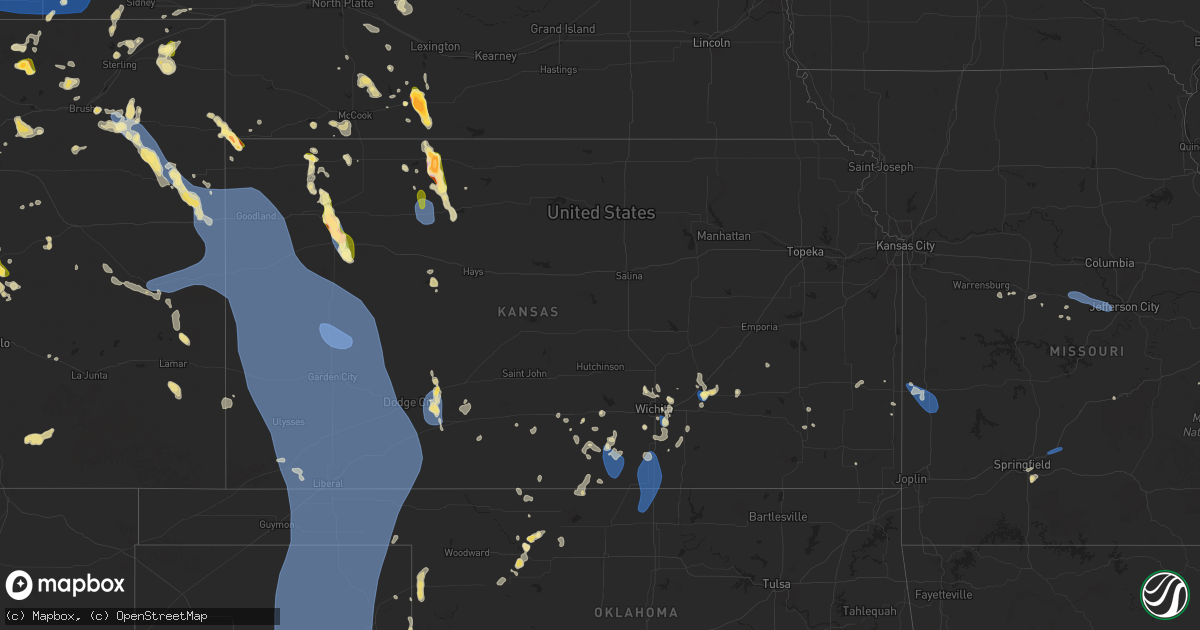
Hail Map in Kansas on July 6, 2025
Get this storm
July 6 map
$229
one time, instant access
Download today. No call, no setup
Keep the $229
Bought the map and want the full workflow? Apply the entire $229 to a subscription within 7 days. None of it is wasted.
Every map, not just this one
This buys you this map. Subscription and you get every map we run, in the markets you choose from a few cities to whole states to nationwide. Plus real-time alerts the moment a storm fires.
Contact data
Name, contact info, occupancy, even credit band for addresses in the footprint. You go from where it hit to who to call.
Become the source they trust
Unlimited branding weather history reports on demand. You already have the documented answer ready for the property owner, and you are the one who showed up with it.
Property data and RoofTrace estimates
Pull up any address you have got, its value and the exact code rules for that jurisdiction, straight from One Click Code. Then RoofTrace estimates the squares, pitch, and roof value, priced the way you price.
Storm reports in Kansas
Kansas
| Date | Description |
|---|---|
| 07/06/20256:59 PM CDT | Chaser estimated 60 mph wind gust with near zero visibility in rain. |
| 07/06/20256:35 PM CDT | Kegt. |
| 07/06/20256:34 PM CDT | Delayed report. Reported via mesonet kkscolby59. |
| 07/06/20256:30 PM CDT | Report from mping: quarter |
| 07/06/20255:53 PM CDT | Limbs down. |
| 07/06/20255:49 PM CDT | 50-60 mph. |
| 07/06/20255:48 PM CDT | Site khlc reports 59 mph wind gust. |
| 07/06/20255:29 PM CDT | Estimated 60-65. |
| 07/06/20255:28 PM CDT | Four inch diameter maple branch broken off. |
| 07/06/20255:24 PM CDT | Accuweather meteorologist. |
| 07/06/20255:20 PM CDT | A local report indicates 1.00 inch wind near 5 NNE Blakeman |
| 07/06/20255:14 PM CDT | Estimated 50-60 mph gusts. |
| 07/06/20255:02 PM CDT | Trained spotter reports one inch hail. |
| 07/06/20254:55 PM CDT | A local report indicates 70 MPH wind near 4 SE El Dorado |
| 07/06/20254:50 PM CDT | Numerous limbs reported down |
| 07/06/20254:50 PM CDT | Numerous limbs reported down in the southeast part of el dorado. |
| 07/06/20254:48 PM CDT | Trained spotter reports hail up to 3 inches. Damage to north facing windows. |
| 07/06/20254:40 PM CDT | 6 to 8 inch diameter tree limbs down. |
| 07/06/20254:37 PM CDT | Estimated 60-65 mph. |
| 07/06/20254:35 PM CDT | A local report indicates 66 MPH wind near 4 SE El Dorado |
| 07/06/20254:35 PM CDT | Delayed entry. Text report of golf ball sized hail. |
| 07/06/20254:33 PM CDT | Nickel and quarter sized hail reported. |
| 07/06/20251:00 AM CDT | A local report indicates 69 MPH wind near 2 ENE Garden City |
| 07/06/202512:47 AM CDT | A local report indicates 58 MPH wind near 6 S Deerfield |
| 07/06/202512:41 AM CDT | A local report indicates 62 MPH wind near 4 SW Friend |
| 07/06/202512:40 AM CDT | A local report indicates 66 MPH wind near 3 NE Lakin |
| 07/06/202512:35 AM CDT | A local report indicates 78 MPH wind near 2 E Shallow Water |
| 07/06/202512:01 AM CDT | Ambient weather site leesimons_farms_ reports the gust. |
| 07/05/202511:56 PM CDT | Kansas mesonet site reports the gust. |
| 07/05/202511:54 PM CDT | Kansas mesonet site reports a 60 mph wind gust. |
| 07/05/202511:24 PM CDT | Cw6099. |
| 07/05/202511:15 PM CDT | Kansas mesonet site reports a 2m wind of 59 mph. |
| 07/05/202511:06 PM CDT | Site wallace on ks mesonet measured 59 mph wind gust. |
| 07/05/202510:58 PM CDT | Delayed entry. Ksn storm chaser measured 82 mph wind gust at mm 28 on i-70. |
| 07/05/202510:40 PM CDT | Site kksweska9 measured 72 mph wind gust. |
| 07/05/202510:40 PM CDT | Asos station kgld goodland. |
| 07/05/20259:06 PM CDT | Sizeable tree limb down. |
| 07/05/20259:05 PM CDT | A local report indicates 58 MPH wind near 3 WNW Ford |
| 07/05/20257:14 PM CDT | Very heavy rain and estimated wind gusts to around 60 mph. |
| 07/05/20257:12 PM CDT | Koel measured 62 mph wind gust. |
| 07/05/20257:10 PM CDT | Spotter reports 2 inch green tree limb down in oakley. Time estimated from radar. |
| 07/05/20257:09 PM CDT | Chaser sent in picture of quarter sized hail... 8 miles north of oakley. |
| 07/05/20257:07 PM CDT | Reported via ambient weather station dog_house. |
All States Impacted by Hail Map on July 6, 2025
Cities Impacted by Hail Map on July 6, 2025
- Kit Carson, CO
- Eads, CO
- Cheyenne Wells, CO
- Sheridan Lake, CO
- Arapahoe, CO
- Burlington, CO
- Bethune, CO
- Idalia, CO
- Kanorado, KS
- Saint Francis, KS
- Weskan, KS
- Sharon Springs, KS
- Goodland, KS
- Tribune, KS
- Martin, SD
- Wounded Knee, SD
- Batesland, SD
- Pine Ridge, SD
- Gordon, NE
- Allen, SD
- Merriman, NE
- Tuthill, SD
- Cody, NE
- Nenzel, NE
- Kilgore, NE
- Valentine, NE
- Crookston, NE
- Purdum, NE
- Brewster, NE
- Hammond, LA
- Stapleton, NE
- Ponchatoula, LA
- Arnold, NE
- Scotia, NE
- Gothenburg, NE
- Gonzales, LA
- Advance, MO
- Whitewater, MO
- Maxwell, NE
- Greeley, NE
- Chaffee, MO
- Spalding, NE
- Primrose, NE
- Cedar Rapids, NE
- Brady, NE
- Donaldsonville, LA
- Farnam, NE
- Callaway, NE
- Cozad, NE
- Geismar, LA
- Darrow, LA
- Prairieville, LA
- Belgrade, NE
- White Castle, LA
- Albion, NE
- Troy, MO
- Saint Edward, NE
- Parma, MO
- Eureka, KS
- Fortuna, MO
- Tipton, MO
- Versailles, MO
- Fullerton, NE
- Eustis, NE
- Richards, MO
- Modoc, IL
- Evansville, IL
- Genoa, NE
- Franklinton, LA
- Catron, MO
- Belle Rose, LA
- Arapahoe, NE
- Wolbach, NE
- Silver Creek, NE
- Monroe, NE
- Deer Trail, CO
- Edgewood, NM
- Holbrook, NE
- Curtis, NE
- Elwood, NE
- Clarks, NE
- Sandia Park, NM
- Cedar Crest, NM
- Deerfield, MO
- Nevada, MO
- Maywood, NE
- Madison, KS
- Pierre Part, LA
- Hamilton, KS
- Edison, NE
- Agate, CO
- Tijeras, NM
- Hayes Center, NE
- Bronson, KS
- Columbus, NE
- Saint Martinville, LA
- Kenner, LA
- Eldorado, TX
- Montezuma, NM
- Stockville, NE
- East Saint Louis, IL
- Madison, IL
- Moundville, MO
- Cambridge, NE
- Cheyenne, WY
- Beaver City, NE
- New Iberia, LA
- Moran, KS
- Ozona, TX
- Moorefield, NE
- San Jose, NM
- Metairie, LA
- Wilsonville, NE
- Hendley, NE
- Collinsville, IL
- Woodrow, CO
- Wardell, MO
- Hayti, MO
- Bragg City, MO
- Chugwater, WY
- Portageville, MO
- Sedalia, MO
- Benton, KS
- Wichita, KS
- Saint Louis, MO
- Bartley, NE
- Indianola, NE
- McCook, NE
- Smithton, MO
- El Dorado, KS
- Scott, LA
- Lafayette, LA
- Burns, KS
- Granite City, IL
- Venice, IL
- Lovejoy, IL
- Fe Warren Afb, WY
- Trenton, NE
- Culbertson, NE
- Pontotoc, MS
- Marine, IL
- Saint Jacob, IL
- Norton, KS
- Lebanon, IL
- Monticello, AR
- Andover, KS
- Des Moines, NM
- Capulin, NM
- Duson, LA
- Vancourt, TX
- Fort Scott, KS
- Knob Noster, MO
- Alamogordo, NM
- Haxtun, CO
- Fleming, CO
- Millstadt, IL
- Belleville, IL
- Brainard, NE
- Ribera, NM
- Lenora, KS
- Almena, KS
- Christoval, TX
- Edwardsville, IL
- O'Fallon, IL
- Fairview Heights, IL
- Sedgwick, CO
- Ponderosa, NM
- Akron, CO
- Stewardson, IL
- Herrick, IL
- Shelbyville, IL
- Strasburg, IL
- La Monte, MO
- Green Ridge, MO
- Lakewood, IL
- Tower Hill, IL
- Cowden, IL
- Logan, KS
- Atwood, KS
- Louisiana, MO
- Garland, KS
- Oberlin, KS
- Herndon, KS
- Derby, KS
- Raton, NM
- Windsor, MO
- Waynesville, MO
- Murdock, KS
- Mebane, NC
- Leon, KS
- Coffeen, IL
- Greenville, IL
- Donnellson, IL
- Ozark, MO
- Alva, OK
- Iraan, TX
- Rogersville, MO
- Fillmore, IL
- Bogue, KS
- Douglass, KS
- Mulvane, KS
- Fountain Hill, AR
- Wilmar, AR
- Hermitage, AR
- Clearwater, KS
- Arcadia, KS
- Larkspur, CO
- Witt, IL
- Ramsey, IL
- Neoga, IL
- Windsor, IL
- Briggsdale, CO
- Grover, CO
- Hamburg, AR
- Elbert, CO
- Pine Bluffs, WY
- Hillsdale, WY
- Carpenter, WY
- Burns, WY
- Valley Center, KS
- Wheatland, WY
- Bingham, IL
- Kingman, KS
- Steelville, MO
- Belle Plaine, KS
- Cunningham, KS
- Bushnell, NE
- Colorado Springs, CO
- Norwich, KS
- Milton, KS
- Colby, KS
- Rapid City, SD
- Sedgwick, KS
- Moriarty, NM
- Encino, NM
- Carmen, OK
- Beecher City, IL
- Altamont, IL
- Guernsey, WY
- Monument, CO
- Manitou Springs, CO
- Benedict, KS
- Sterling, CO
- Dacoma, OK
- Aline, OK
- Glendo, WY
- Lucedale, MS
- Charlotte, TX
- Stockton, KS
- Harper, KS
- Argonia, KS
- Spivey, KS
- Manville, WY
- Gem, KS
- Fort Morgan, CO
- Wray, CO
- Scott Air Force Base, IL
- Effingham, IL
- Crook, CO
- Peck, KS
- Model, CO
- Wellington, KS
- Hermosa, SD
- Peyton, CO
- Hartville, WY
- Clayton, NM
- Fort Hancock, TX
- Torrington, WY
- Jay Em, WY
- Damar, KS
- Iliff, CO
- Gurley, NE
- Chappell, NE
- Chester, OK
- Lodgepole, NE
- Oakley, KS
- Dalton, NE
- Kechi, KS
- Peetz, CO
- Buffalo, KS
- Gillette, WY
- Fountain, CO
- Waynoka, OK
- Matheson, CO
- Breaux Bridge, LA
- Lusk, WY
- Snyder, CO
- New Raymer, CO
- Youngsville, LA
- Broussard, LA
- Sunset, LA
- Carencro, LA
- Rexford, KS
- Mode, IL
- Roggen, CO
- Sidney, NE
- Bayard, NE
- Rock, KS
- Udall, KS
- Simla, CO
- Bunker, MO
- Stonington, IL
- Fairview, OK
- Grinnell, KS
- Altoona, KS
- Sawyer, KS
- Haigler, NE
- Bridgeport, NE
- Golden, CO
- Broadwater, NE
- Wakeeney, KS
- Ellis, KS
- Ogallah, KS
- Mutual, OK
- Denver, CO
- Fairburn, SD
- Coats, KS
- Leesville, LA
- Lena, LA
- Bunkie, LA
- Lance Creek, WY
- Bluff City, KS
- Angora, NE
- Prairie Du Rocher, IL
- Anthony, KS
- Boyce, LA
- Otis, CO
- Keenesburg, CO
- Lisco, NE
- Rye, CO
- Walsenburg, CO
- Avondale, CO
- Mosquero, NM
- Springfield, MO
- Aurora, CO
- Oswego, KS
- Wiggins, CO
- Arvada, CO
- Wheat Ridge, CO
- Spearville, KS
- Hanston, KS
- Haviland, KS
- Helena, OK
- Padroni, CO
- Seiling, OK
- Bennett, CO
- Hugo, CO
- Ramah, CO
- Alliance, NE
- Hulett, WY
- Moorcroft, WY
- Weston, WY
- Wright, KS
- Florissant, CO
- Kimball, NE
- Corona, NM
- Parks, NE
- Manchester, OK
- Amorita, OK
- Waldron, KS
- Kinsley, KS
- Ford, KS
- Ellsworth, NE
- Cope, CO
- Yancey, TX
- D Hanis, TX
- Dodge City, KS
- Greensburg, KS
- Guffey, CO
- Joes, CO
- Hemingford, NE
- Yuma, CO
- Newcastle, WY
- Kirk, CO
- Tucumcari, NM
- Manzanola, CO
- Karval, CO
- Alzada, MT
- Potter, NE
- Shawnee, WY
- Oshkosh, NE
- Stratton, CO
- Olney Springs, CO
- Cascade, CO
- Jetmore, KS
- Farmerville, LA
- Florence, CO
- Wetmore, CO
- Broadus, MT
- Bingham, NE
- Kiowa, KS
- Anton Chico, NM
- Cheney, KS
- Lakeside, NE
- Osage, WY
- Edson, KS
- Brewster, KS
- Calhan, CO
- Bucklin, KS
- Wallace, KS
- Penrose, CO
- Lilbourn, MO
- Lead, SD
- Hill City, SD
- Yoder, CO
- El Dorado, AR
- Canon City, CO
- Westby, MT
- Winona, KS
- Leoti, KS
- Pratt, KS
- Laverne, OK
- Shattuck, OK
- Gage, OK
- Deerfield, KS
- Lakin, KS
- Marienthal, KS
- Scott City, KS
- Arnett, OK
- Holcomb, KS
- Lamar, CO
- Sundance, WY
- Garden City, KS
- Healy, KS
- Upton, WY
- Holly, CO
- Syracuse, KS
- Bronaugh, MO
- Milo, MO
- Sheldon, MO
- Marshfield, MO
- Strafford, MO
- Canadian, TX
- Manter, KS
- Durham, OK
- Reydon, OK
- Cimarron, KS
- Dighton, KS
- Two Buttes, CO
- Walsh, CO
- Granada, CO
- Mcconnell Afb, KS
- Danville, KS
- Freeport, KS
- Caldwell, KS
- Milan, KS
- South Haven, KS
- Geuda Springs, KS
- Braman, OK
- Nardin, OK
- Medford, OK
- Blackwell, OK
- Deer Creek, OK
- Hugoton, KS
- Wheeler, TX
- Mobeetie, TX
- Briscoe, TX
- Shamrock, TX
- Rozet, WY
- Devils Tower, WY
- Keystone, SD
- Hill City, KS
- Benkelman, NE
- Wellfleet, NE
- Clarendon, TX
- Lelia Lake, TX
- Hedley, TX
- Faith, SD
- Wasta, SD
- Ord, NE
- Ericson, NE
- Hay Springs, NE
- Stratton, NE
- Dix, NE
- Penokee, KS
- Hoxie, KS
- Pierceville, KS
- Ulysses, KS
- Kendall, KS
- Johnson, KS
- Satanta, KS
- Hooker, OK
- Moscow, KS
- Sublette, KS
- Montezuma, KS
- Tyrone, OK
- Englewood, KS
- Plains, KS
- Turpin, OK
- Fowler, KS
- Copeland, KS
- Liberal, KS
- Ensign, KS
- Ingalls, KS
- Minneola, KS
- Meade, KS
- Kismet, KS
- Forgan, OK
- Guymon, OK
- Hardesty, OK
- Gate, OK
- Beaver, OK
- Balko, OK
- Gruver, TX
- Spearman, TX
- Perryton, TX
- Booker, TX
- Morse, TX
- Stinnett, TX
- Borger, TX
- Claude, TX
- Miami, TX
- Pampa, TX
- Skellytown, TX
- Panhandle, TX
- Fritch, TX
- Mclean, TX
- Follett, TX
- White Deer, TX
- Higgins, TX
- Darrouzett, TX
- Lipscomb, TX
- Groom, TX
- Quitaque, TX
- Lakeview, TX
- Quail, TX
- Memphis, TX
- California, MO
- Clarksburg, MO
- Centertown, MO
- Lohman, MO
- Jefferson City, MO


