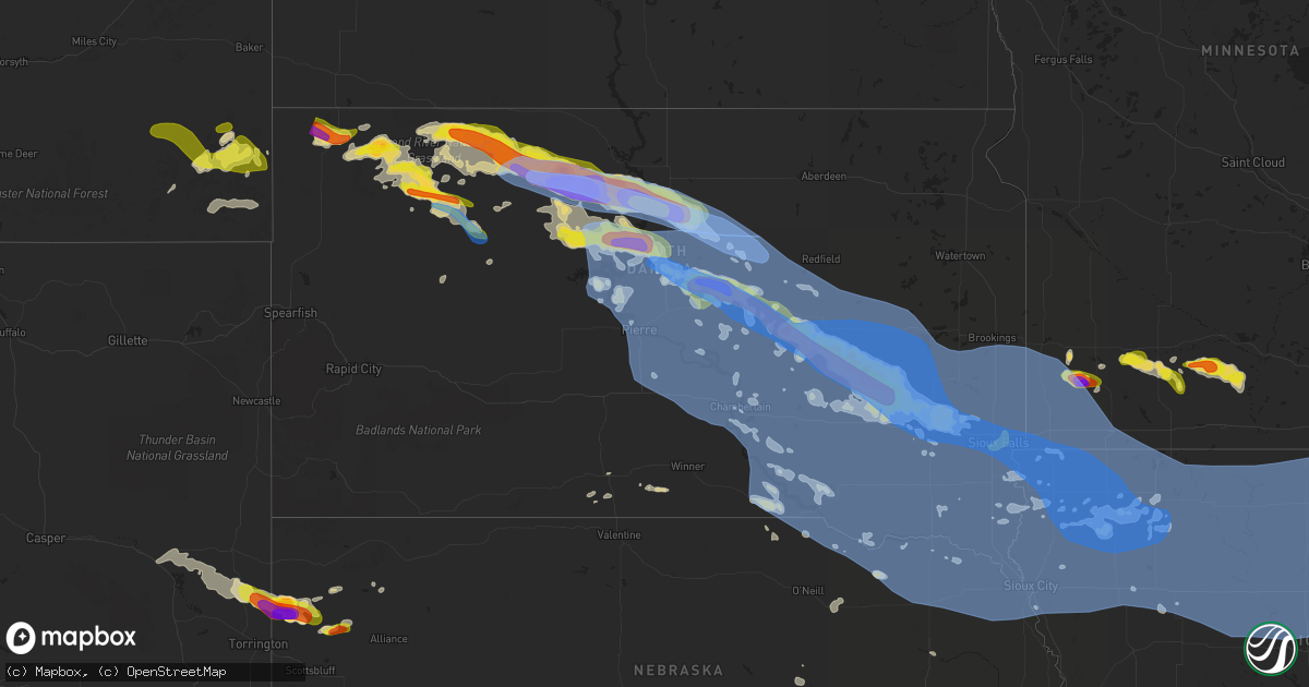
Hail Map in South Dakota on July 5, 2022
Get this storm
July 5 map
$229
one time, instant access
Download today. No call, no setup
Keep the $229
Bought the map and want the full workflow? Apply the entire $229 to a subscription within 7 days. None of it is wasted.
Every map, not just this one
This buys you this map. Subscription and you get every map we run, in the markets you choose from a few cities to whole states to nationwide. Plus real-time alerts the moment a storm fires.
Contact data
Name, contact info, occupancy, even credit band for addresses in the footprint. You go from where it hit to who to call.
Become the source they trust
Unlimited branding weather history reports on demand. You already have the documented answer ready for the property owner, and you are the one who showed up with it.
Property data and RoofTrace estimates
Pull up any address you have got, its value and the exact code rules for that jurisdiction, straight from One Click Code. Then RoofTrace estimates the squares, pitch, and roof value, priced the way you price.
Storm reports in South Dakota
South Dakota
| Date | Description |
|---|---|
| 07/05/20224:33 PM CDT | Asos station kfsd sioux falls airport. |
| 07/05/20224:32 PM CDT | Mesonet station 53 sd rwis north sioux city. |
| 07/05/20224:32 PM CDT | Mesonet station 176 sd rwis davis. |
| 07/05/20224:28 PM CDT | Mesonet station 53 sd rwis north sioux city. |
| 07/05/20224:25 PM CDT | Mesonet station ctns2 colton 2 ese |
| 07/05/20224:08 PM CDT | Mesonet station 310 sd rwis parker. |
| 07/05/20224:03 PM CDT | Mesonet station 176 sd rwis davis. |
| 07/05/20223:53 PM CDT | An nws employee reported 85-90 mph winds near the wall lake area. |
| 07/05/20223:37 PM CDT | A local report indicates 60 MPH wind near MONTROSE |
| 07/05/20223:36 PM CDT | Personal weather station: ksdbridg6. |
| 07/05/20223:35 PM CDT | A local report indicates 1.00 inch wind near 4 SW SIOUX FALLS |
| 07/05/20223:30 PM CDT | Mesonet station 297 sd rwis howard. |
| 07/05/20223:30 PM CDT | Reported 1 inch hail with minor leaf and small limb damage. Time estimated using radar. |
| 07/05/20223:28 PM CDT | Mesonet station 197 sd rwis gayville. |
| 07/05/20223:22 PM CDT | Personal weather station: ksdspring9. |
| 07/05/20223:20 PM CDT | Awos station kykn yankton municipal airport. |
| 07/05/20223:20 PM CDT | Mesonet station 213 sd rwis alexandria. |
| 07/05/20223:20 PM CDT | Significant roof damage to salem armory. |
| 07/05/20223:16 PM CDT | Mesonet station 297 sd rwis howard. Rwis sustained gusts 70+ mph for roughly 20 to 30 minutes. |
| 07/05/20223:15 PM CDT | Reported from personal weather station. |
| 07/05/20223:06 PM CDT | Significant roof damage to agriculture building. Time estimated via radar. |
| 07/05/20223:00 PM CDT | Stop sign blown over. Also noted pea to quarter size hail. |
| 07/05/20222:55 PM CDT | Mesonet station 179 sd rwis tyndall. |
| 07/05/20222:52 PM CDT | Asos station kmhe mitchell municipal airport. |
| 07/05/20222:50 PM CDT | A local report indicates 60 MPH wind near 6 NE TYNDALL |
| 07/05/20222:42 PM CDT | Mesonet station 211 sd rwis cavour. |
| 07/05/20222:38 PM CDT | Mesonet station 6 sd rwis forestburg. |
| 07/05/20222:30 PM CDT | Also noted that there were multiple trees down across the area. |
| 07/05/20222:30 PM CDT | Mesonet station 305 sd rwis lane. |
| 07/05/20222:28 PM CDT | Asos station kmhe mitchell municipal airport. |
| 07/05/20222:27 PM CDT | Mesonet station 26 sd rwis tripp. |
| 07/05/20222:24 PM CDT | Mesonet station 244 sd rwis ft. Randall dam. |
| 07/05/20222:10 PM CDT | Mesonet station ew7290 butte 8nnw. |
| 07/05/20222:10 PM CDT | A local report indicates 80 MPH wind near WOONSOCKET |
| 07/05/20222:05 PM CDT | Mesonet station 6 sd rwis forestburg. |
| 07/05/20222:05 PM CDT | Mesonet station 304 sd rwis corsica. |
| 07/05/20222:03 PM CDT | Asos station khon huron regional airport. |
| 07/05/20221:59 PM CDT | Mesonet station 284 jct sd28/sd37 |
| 07/05/20221:53 PM CDT | A local report indicates 60 MPH wind near WEWELA |
| 07/05/20221:50 PM CDT | Mesonet station 305 sd rwis lane. |
| 07/05/20221:41 PM CDT | Mesonet station 289 lees corner |
| 07/05/20221:40 PM CDT | Trained spotter relayed via county emergency manager. |
| 07/05/20221:40 PM CDT | Mesonet station 164 sd rwis wolsey. |
| 07/05/20221:38 PM CDT | A local report indicates 64 MPH wind near WEWELA |
| 07/05/20221:37 PM CDT | Mesonet station 154 sd rwis platte-winner bridge. |
| 07/05/20221:35 PM CDT | Estimated 60-65 mph and a shelf cloud. |
| 07/05/20221:30 PM CDT | Awos station k4x4 wessington springs. |
| 07/05/20221:26 PM CDT | Mesonet station 289 lees corner |
| 07/05/20221:24 PM CDT | Mesonet station 183 macs corner |
| 07/05/20221:20 PM CDT | Measured from personal weather station. |
| 07/05/20221:19 PM CDT | A local report indicates 61 MPH wind near 1 NE WINNER |
| 07/05/20221:17 PM CDT | Mesonet station rhus2 danforth 5 e. Time estimated via radar. |
| 07/05/20221:10 PM CDT | A local report indicates 59 MPH wind near 7 ESE ROSEBUD |
| 07/05/20221:06 PM CDT | Mesonet station 158 miranda |
| 07/05/20221:03 PM CDT | A local report indicates 60 MPH wind near 4 SSE WITTEN |
| 07/05/20221:00 PM CDT | Trees uprooted and major tree limb damage in town. |
| 07/05/202212:55 PM CDT | Via sd mesonet ocms2. |
| 07/05/202212:54 PM CDT | Mesonet station 183 macs corner |
| 07/05/202212:53 PM CDT | Mesonet station 312 ree heights |
| 07/05/202212:51 PM CDT | Mesonet station 158 miranda (sdd |
| 07/05/202212:51 PM CDT | Mesonet station 289 lees corner |
| 07/05/202212:51 PM CDT | Mesonet station 158 miranda |
| 07/05/202212:51 PM CDT | Mesonet station 215 jct sd47/sd26 |
| 07/05/202212:50 PM CDT | A local report indicates 68 MPH wind near MILLER |
| 07/05/202212:44 PM CDT | Mesonet station 183 macs corner |
| 07/05/202212:42 PM CDT | Personal weather station. |
| 07/05/202212:38 PM CDT | Mesonet station 312 ree heights |
| 07/05/202212:36 PM CDT | Mesonet station 215 jct sd47/sd26 |
| 07/05/202212:33 PM CDT | Mesonet station 312 ree heights |
| 07/05/202212:16 PM CDT | Mesonet station 215 jct sd47/sd26 |
| 07/05/202212:15 PM CDT | Roof blown off home. |
| 07/05/202212:15 PM CDT | Sd mesonet station hihs2. |
| 07/05/202212:10 PM CDT | Also had 60 mph winds. |
| 07/05/202212:10 PM CDT | Mesonet station dvi01443 pierre. |
| 07/05/202212:05 PM CDT | Mesonet station 185 blunt |
| 07/05/202211:57 AM CDT | Mesonet station 13 vivian |
| 07/05/202211:53 AM CDT | Asos station kpir pierre muni ap. |
| 07/05/202211:40 AM CDT | Thunderstorm outflow winds. |
| 07/05/202211:35 AM CDT | Personal weather station. |
| 07/05/202211:32 AM CDT | A local report indicates 60 MPH wind near NEW UNDERWOOD |
| 07/05/202211:26 AM CDT | Mesonet station 212 agar |
| 07/05/202211:21 AM CDT | Mesonet station 212 agar |
| 07/05/202211:15 AM CDT | A local report indicates 60 MPH wind near 5 NE OPAL |
| 07/05/202211:15 AM CDT | Occurred at oahe dam. |
| 07/05/202211:09 AM CDT | Mesonet station 157 forest city |
| 07/05/202210:55 AM CDT | Personal weather station. |
| 07/05/202210:55 AM CDT | A local report indicates 60 MPH wind near 5 NE OPAL |
| 07/05/202210:55 AM CDT | Ssw dolton hutchinson sd 4345 9742 personal weather station: ksdbridg6. |
| 07/05/202210:32 AM CDT | Time estimated from radar. |
| 07/05/202210:31 AM CDT | Mesonet station 204 ridgeview |
| 07/05/202210:30 AM CDT | A local report indicates 60 MPH wind near 7 SE MUD BUTTE |
| 07/05/202210:13 AM CDT | 2.5 inches of rain fell as well. |
| 07/05/20229:55 AM CDT | Heavy rain... Out of electricity for 30 minutes. |
| 07/05/20229:40 AM CDT | Sdsu mesonet. |
| 07/05/20229:40 AM CDT | A local report indicates 60 MPH wind near FAITH |
| 07/05/20229:37 AM CDT | Relayed via social media picture... Comparing to dollar bill. Time estimated by radar. |
| 07/05/20229:20 AM CDT | Winds estimated at 70-80 mph. Skylights broke out of house. Damage to pvc fence. Tree branches down. |
| 07/05/20229:15 AM CDT | Extensive damage north of isabel. Damage to trees... Trees uprooted... Broken house and vehicle windows... Machine shed destroyed... Grain bins destroyed... Complete lo |
| 07/05/20229:13 AM CDT | A local report indicates 70 MPH wind near 1 N BUFFALO |
| 07/05/20229:10 AM CDT | Wind and hail from 0750 to 0810 |
| 07/05/20229:10 AM CDT | Damage picture relayed via social media. Extensive damage to large outdoor storage building. Time approximated by radar. |
| 07/05/20229:10 AM CDT | Wind and hail from 0750 to 0810 |
| 07/05/20229:05 AM CDT | Many trees uprooted. |
| 07/05/20228:50 AM CDT | Hail and wind lasted from 0750 to around 0810 |
| 07/05/20228:50 AM CDT | Hail and wind lasted from 0750 to around 0810 |
| 07/05/20228:48 AM CDT | Hail from 0748-0800 |
| 07/05/20228:30 AM CDT | A local report indicates 60 MPH wind near 7 SSE BISON |
| 07/05/20228:30 AM CDT | A local report indicates 1.75 inch wind near 11 SSW BISON |
| 07/05/20227:50 AM CDT | At 1249 PM CDT, severe thunderstorms were located along a line extending from 5 miles south of Reliance to near Parmelee, moving southeast at 50 mph. HAZARD...70 mph wind gusts. SOURCE...Radar indicated. IMPACT...Expect considerable tree damage. Damage is likely to mobile homes, roofs, and outbuildings. Locations impacted include... Winner, Mission, White River, Rosebud, Saint Francis, Parmelee, Colome, Okreek, Spring Creek, Norris, Ideal, Wood, Carter, Cedar Butte, Millboro, Mosher, Keyapaha, Witten, Hamill and Upper Cut Meat. |
| 07/05/20227:43 AM CDT | At 1242 PM CDT, severe thunderstorms were located along a line extending from near Sunshine Bible Academy to near Pleasant Valley Country Church to Medicine Butte, moving southeast at 40 mph. HAZARD...70 mph wind gusts and nickel size hail. SOURCE...Trained weather spotters. IMPACT...Expect considerable tree damage. Damage is likely to mobile homes, roofs, and outbuildings. Severe thunderstorms will be near... Chamberlain around 110 PM CDT. Wessington Springs around 125 PM CDT. Alpena and Lane around 135 PM CDT. Kimball around 140 PM CDT.Other locations impacted by these severe thunderstorms includePukwana. |
| 07/05/20227:40 AM CDT | Hail was mainly half-inch... But there were pieces up to the size of a golf ball. |
| 07/05/20227:40 AM CDT | Hail was mainly half-inch... But there were pieces up to the size of a golf ball. |
| 07/05/20227:39 AM CDT | At 1238 PM CDT, a severe thunderstorm was located near Miller, moving southeast at 45 mph. THIS IS A DESTRUCTIVE STORM FOR WESSINGTON, WOSLEY, AND HURON. HAZARD...80 mph wind gusts and two inch hail. SOURCE...Trained weather spotters. IMPACT...Flying debris will be dangerous to those caught without shelter. Mobile homes will be heavily damaged. Expect considerable damage to roofs, windows, and vehicles. Extensive tree damage and power outages are likely. This severe thunderstorm will be near... Wessington around 105 PM CDT. Wolsey around 120 PM CDT. Virgil around 125 PM CDT. Huron around 135 PM CDT.Other locations impacted by this severe thunderstorm includeBroadland. |
| 07/05/20227:30 AM CDT | A local report indicates 1.75 inch wind near 1 SW SHADEHILL |
| 07/05/20227:21 AM CDT | At 1221 PM CDT, severe thunderstorms were located along a line extending from 7 miles south of Miller Dale Colony to near 5 Mile Corner, moving southeast at 45 mph. HAZARD...70 mph wind gusts and nickel size hail. SOURCE...Trained weather spotters. IMPACT...Expect considerable tree damage. Damage is likely to mobile homes, roofs, and outbuildings. Severe thunderstorms will be near... Sunshine Bible Academy around 1225 PM CDT. Pleasant Valley Country Church around 1230 PM CDT.Other locations in the path of these severe thunderstorms includeGann Valley. |
| 07/05/20227:12 AM CDT | At 1211 PM CDT, severe thunderstorms were located along a line extending from 6 miles southwest of Burkmere to near Highmore, moving east at 40 mph. THESE ARE DESTRUCTIVE STORMS FOR NORTHERN HYDE AND HAND COUNTIES. HAZARD...80 mph wind gusts and two inch hail. SOURCE...Trained weather spotters. At 1207 PM, 60 mph wind and golf ball sized hail was reported 5 miles north of Highmore. IMPACT...Flying debris will be dangerous to those caught without shelter. Mobile homes will be heavily damaged. Expect considerable damage to roofs, windows, and vehicles. Extensive tree damage and power outages are likely. Severe thunderstorms will be near... Highmore around 1215 PM CDT. Ree Heights around 1230 PM CDT.Other locations in the path of these severe thunderstorms includeOrient, Miller Dale Colony, Miranda, Polo, Miller, St. Lawrence,Rockham, Zell, Burdette and Vayland. |
| 07/05/20226:47 AM CDT | At 1145 AM CDT/1045 AM MDT/, severe thunderstorms were located along a line extending from Harrold to near Pierre, moving southeast at 50 mph. HAZARD...70 mph wind gusts and quarter size hail. SOURCE...Trained weather spotters. This storm has a history of producing 60 to 70 mph winds in the Pierre area. IMPACT...Hail damage to vehicles is expected. Expect considerable tree damage. Wind damage is also likely to mobile homes, roofs, and outbuildings. Severe thunderstorms will be near... Harrold around 1150 AM CDT. Holabird around 1155 AM CDT. Highmore and Rousseau around 1200 PM CDT.Other locations in the path of these severe thunderstorms includeCedar Creek Rec Area and Joe Creek Rec Area. |
| 07/05/20226:26 AM CDT | At 1125 AM CDT, severe thunderstorms were located along a line extending from near Hoven to near Agar, moving east at 40 mph. HAZARD...80 mph wind gusts and two inch hail. SOURCE...Trained weather spotters. At 1109 AM CDT, a 71 mph wind gust was reported near Whitlocks Bay Rec Area. IMPACT...Flying debris will be dangerous to those caught without shelter. Mobile homes will be heavily damaged. Expect considerable damage to roofs, windows, and vehicles. Extensive tree damage and power outages are likely. Severe thunderstorms will be near... Hoven around 1130 AM CDT. Tolstoy around 1140 AM CDT. Stone Lake around 1145 AM CDT.Other locations in the path of these severe thunderstorms includeOnaka, Brentwood Colony, Burkmere, Norbeck, Blumengard Colony andFaulkton. |
| 07/05/20226:12 AM CDT | At 1111 AM CDT/1011 AM MDT/, severe thunderstorms were located along a line extending from near Sully Lake to 6 miles northwest of Okobojo Point Rec Area, moving southeast at 50 mph. HAZARD...70 mph wind gusts and quarter size hail. SOURCE...Radar indicated. IMPACT...Hail damage to vehicles is expected. Expect considerable tree damage. Wind damage is also likely to mobile homes, roofs, and outbuildings. Severe thunderstorms will be near... Sully Lake around 1115 AM CDT. Onida and Oahe Mission Rec Area around 1120 AM CDT. Grey Goose and Overlook Rec Area around 1130 AM CDT. Southern Lake Oahe around 1030 AM MDT.Other locations in the path of these severe thunderstorms includeHarrold, Blunt, Canning and Holabird. |
| 07/05/20225:42 AM CDT | At 1041 AM CDT/941 AM MDT/, severe thunderstorms were located along a line extending from Lake Oahe to 6 miles south of Ridgeview, moving east at 35 mph. THESE ARE DESTRUCTIVE STORMS FOR CENTRAL LAKE OAHE. HAZARD...80 mph wind gusts and tennis ball size hail. SOURCE...Trained weather spotters. At 920 AM MDT, tennis ball hail was reported near Firesteel. IMPACT...Flying debris will be dangerous to those caught without shelter. Mobile homes will be heavily damaged. Expect considerable damage to roofs, windows, and vehicles. Extensive tree damage and power outages are likely. Severe thunderstorms will be near... Blackfoot around 945 AM MDT. Swan Creek Rec Area around 1050 AM CDT. Akaska around 1100 AM CDT.Other locations in the path of these severe thunderstorms includeLowry, Sutton Bay Rec Area, Hoven, Gorman, Agar, Tolstoy andCottonwood Lake Near Agar. |
| 07/05/20225:18 AM CDT | At 1018 AM MDT, a severe thunderstorm was located 3 miles southeast of Curlew Lake, or 27 miles east of Rapid City, moving southeast at 35 mph. HAZARD...60 mph wind gusts and quarter size hail. SOURCE...Radar indicated. IMPACT...Hail damage to vehicles is expected. Expect wind damage to roofs, siding, and trees. Locations impacted include... Wall, New Underwood, Wasta, Scenic, Owanka, Wicksville, Curlew Lake, Viewfield and northern Badlands National Park.This includes Interstate 90 in South Dakota between Mile Markers 76and 112. |
| 07/05/20225:12 AM CDT | At 1011 AM MDT, severe thunderstorms were located along a line extending from 5 miles southwest of Isabel to near Elm Springs, moving east at 45 mph. HAZARD...60 mph wind gusts and quarter size hail. SOURCE...Radar indicated. IMPACT...Hail damage to vehicles is expected. Expect wind damage to roofs, siding, and trees. Locations impacted include... Dupree, Faith, Union Center, Cherry Creek, Milesville, Plainview, Enning, Elm Springs, Usta, Opal, Red Scaffold, Billsburg, Red Owl, Iron Lightning, Grindstone, Glad Valley, Creighton, South Eagle Butte, Marcus and Bridger. |
| 07/05/20224:41 AM CDT | At 940 AM CDT/840 AM MDT/, a severe thunderstorm was located near White Horse, or 24 miles southwest of Mobridge, moving east at 40 mph. HAZARD...80 mph wind gusts and tennis ball size hail. SOURCE...Radar indicated. IMPACT...Flying debris will be dangerous to those caught without shelter. Mobile homes will be heavily damaged. Expect considerable damage to roofs, windows, and vehicles. Extensive tree damage and power outages are likely. This severe thunderstorm will be near... Promise around 855 AM MDT. |
| 07/05/20224:28 AM CDT | At 928 AM MDT, severe thunderstorms were located along a line extending from 7 miles southeast of Meadow to 5 miles west of Opal to 7 miles northwest of Hereford, moving southeast at 50 mph. HAZARD...70 mph wind gusts and quarter size hail. SOURCE...Radar indicated. IMPACT...Hail damage to vehicles is expected. Expect considerable tree damage. Wind damage is also likely to mobile homes, roofs, and outbuildings. Locations impacted include... Faith, Union Center, Enning, Meadow, Chance, Elm Springs, Usta, Maurine, Stoneville, Glad Valley, Opal, Fairpoint, Marcus, White Owl, Red Owl, Thunder Butte, Iron Lightning, Owen Lake, Durkee Lake and Arrow Head Buttes. |
| 07/05/20223:56 AM CDT | At 855 AM MDT, severe thunderstorms were located along a line extending from Bear Creek to 11 miles northeast of Marcus, moving south at 45 mph. HAZARD...70 mph wind gusts and quarter size hail. SOURCE...Radar indicated. IMPACT...Hail damage to vehicles is expected. Expect considerable tree damage. Wind damage is also likely to mobile homes, roofs, and outbuildings. Severe thunderstorms will be near... Plainview and Howes around 910 AM MDT. Intersection of Highway 63 and BIA Road 8 around 915 AM MDT.Other locations in the path of these severe thunderstorms includeBridger, Kirley and Grindstone Butte. |
| 07/05/20223:29 AM CDT | At 829 AM MDT, a severe thunderstorm was located 6 miles northwest of Faith, moving southeast at 30 mph. HAZARD...70 mph wind gusts and half dollar size hail. SOURCE...Radar indicated. IMPACT...Hail damage to vehicles is expected. Expect considerable tree damage. Wind damage is also likely to mobile homes, roofs, and outbuildings. Locations impacted include... Faith, Plainview, Marcus, Howes, Red Scaffold, Opal and Durkee Lake. |
| 07/05/20223:14 AM CDT | At 814 AM MDT, a severe thunderstorm was located 8 miles northwest of Firesteel, or 32 miles southwest of Mclaughlin, moving east at 30 mph. HAZARD...Tennis ball size hail and 60 mph wind gusts. SOURCE...Radar indicated. IMPACT...People and animals outdoors will be injured. Expect hail damage to roofs, siding, windows, and vehicles. Expect wind damage to roofs, siding, and trees. This severe thunderstorm will be near... Firesteel around 825 AM MDT.Other locations in the path of this severe thunderstorm includeTimber Lake, Spring Lake and Glencross. |
| 07/05/20222:58 AM CDT | At 758 AM MDT, a severe thunderstorm was located 7 miles south of Chance, or 23 miles northwest of Faith, moving east at 30 mph. HAZARD...Ping pong ball size hail and 60 mph wind gusts. SOURCE...Radar indicated. IMPACT...People and animals outdoors will be injured. Expect hail damage to roofs, siding, windows, and vehicles. Expect wind damage to roofs, siding, and trees. Locations impacted include... Chance, Usta, Glad Valley, Thunder Butte, Red Elm, Iron Lightning and Arrow Head Buttes. |
| 07/05/20222:46 AM CDT | At 746 AM MDT, a severe thunderstorm was located 12 miles west of Klein Ranch, or 34 miles southeast of Lemmon, moving southeast at 25 mph. HAZARD...Ping pong ball size hail. SOURCE...Radar indicated. IMPACT...People and animals outdoors will be injured. Expect damage to roofs, siding, windows, and vehicles. Locations impacted include... Klein Ranch. |
| 07/05/20222:33 AM CDT | At 733 AM MDT, a severe thunderstorm was located 7 miles west of Shambo Ranch, or 31 miles south of Lemmon, moving east at 20 mph. HAZARD...Ping pong ball size hail and 60 mph wind gusts. SOURCE...Radar indicated. IMPACT...People and animals outdoors will be injured. Expect hail damage to roofs, siding, windows, and vehicles. Expect wind damage to roofs, siding, and trees. Locations impacted include... Shambo Ranch. |
| 07/05/20222:12 AM CDT | At 712 AM MDT, a severe thunderstorm was located 4 miles southwest of Bison, or 35 miles south of Hettinger, moving east at 35 mph. HAZARD...Golf ball size hail and 60 mph wind gusts. SOURCE...Radar indicated. IMPACT...People and animals outdoors will be injured. Expect hail damage to roofs, siding, windows, and vehicles. Expect wind damage to roofs, siding, and trees. Locations impacted include... Bison, Meadow, Chance, Sorum, Usta, Prairie City, Date, southern Slim Buttes, Owen Lake and Shadehill Reservoir. |
| 07/05/20221:43 AM CDT | At 643 AM MDT, a severe thunderstorm was located near Shadehill, or 12 miles south of Lemmon, moving east at 35 mph. HAZARD...Golf ball size hail and 60 mph wind gusts. SOURCE...Radar indicated. IMPACT...People and animals outdoors will be injured. Expect hail damage to roofs, siding, windows, and vehicles. Expect wind damage to roofs, siding, and trees. This severe thunderstorm will remain over mainly rural areas of northwestern Corson County. |
| 07/05/20221:37 AM CDT | At 637 AM MDT, a severe thunderstorm was located 9 miles southeast of Ralph, or 28 miles southwest of Hettinger, moving east at 40 mph. HAZARD...Ping pong ball size hail and 60 mph wind gusts. SOURCE...Radar indicated. IMPACT...People and animals outdoors will be injured. Expect hail damage to roofs, siding, windows, and vehicles. Expect wind damage to roofs, siding, and trees. Locations impacted include... Bison, Reva, Ralph, Lodgepole, Prairie City and northwestern Slim Buttes. |
| 07/05/202212:15 AM CDT | At 514 AM MDT, a severe thunderstorm was located 18 miles west of Ladner, or 21 miles east of Ekalaka, moving east at 30 mph. HAZARD...Tennis ball size hail and 70 mph wind gusts, along with very heavy rain. SOURCE...Radar indicated. IMPACT...People and animals outdoors will be injured. Expect hail damage to roofs, siding, windows, and vehicles. Expect considerable tree damage. Wind damage is also likely to mobile homes, roofs, and outbuildings. Locations impacted include... Mill Iron.This replaces the warning previously in effect for this area. |
| 07/05/202212:08 AM CDT | At 508 AM MDT, a severe thunderstorm was located 18 miles east of Ekalaka, moving east at 40 mph. HAZARD...60 mph wind gusts and half dollar size hail. SOURCE...Radar indicated. IMPACT...Hail damage to vehicles is expected. Expect wind damage to roofs, siding, and trees. This severe thunderstorm will remain over mainly rural areas of southwestern Bowman County. |
| 07/05/202212:07 AM CDT | At 506 AM MDT, a severe thunderstorm was located 18 miles east of Ekalaka, moving east at 35 mph. HAZARD...Tennis ball size hail and 60 mph wind gusts. SOURCE...Radar indicated. IMPACT...People and animals outdoors will be injured. Expect hail damage to roofs, siding, windows, and vehicles. Expect wind damage to roofs, siding, and trees. Locations impacted include... Buffalo, Ludlow, Ladner, Table Mountain, South Cave Hills, North Cave Hills and Lake Gardner. |
| 07/04/202211:23 PM CDT | At 422 PM CDT, severe thunderstorms were located along a line extending from near Sioux Center to 8 miles northeast of Jefferson to near Dixon In Dixon County, moving southeast at 50 mph. HAZARD...70 mph wind gusts. SOURCE...Radar indicated. IMPACT...Expect considerable tree damage. Damage is likely to mobile homes, roofs, and outbuildings. Severe thunderstorms will be near... Orange City, North Sioux City, Alton, Merrill and Struble around 430 PM CDT. Hinton around 435 PM CDT. Sioux City, Le Mars and South Sioux City around 440 PM CDT.Other locations in the path of these severe thunderstorms includeSergeant Bluff, Dakota City, Remsen, Wakefield, Moville, Kingsley,Marcus, Lawton, Emerson, Hubbard, Homer, Salix, Sloan, Pierson,Anthon and Hornick. |
| 07/04/202211:00 PM CDT | At 359 PM CDT, severe thunderstorms were located along a line extending from 2 miles north of Vermillion to 6 miles west of Clearwater, moving southeast at 35 mph. HAZARD...60 mph wind gusts and quarter size hail. SOURCE...Radar indicated. IMPACT...Hail damage to vehicles is expected. Expect wind damage to roofs, siding, and trees. Severe thunderstorms will be near... Clearwater around 405 PM CDT.Other locations in the path of these severe thunderstorms includeElgin. |
| 07/04/202210:27 PM CDT | At 326 PM CDT, severe thunderstorms were located along a line extending from near Irene to 7 miles south of Yankton, moving southeast at 40 mph. HAZARD...70 mph wind gusts. SOURCE...Radar indicated. IMPACT...Expect considerable tree damage. Damage is likely to mobile homes, roofs, and outbuildings. Severe thunderstorms will be near... Wakonda around 330 PM CDT. Beresford and Meckling around 345 PM CDT.Other locations in the path of these severe thunderstorms includeVermillion, Union Grove State Park, Alcester, Maskell, Hawarden,Newcastle, Akron, Elk Point, Martinsburg, Ponca, Ireton and PoncaState Park. |
| 07/04/202210:25 PM CDT | At 324 PM CDT, severe thunderstorms were located along a line extending from 2 miles north of Wakonda to Page, moving southeast at 45 mph. HAZARD...60 mph wind gusts and quarter size hail. SOURCE...Radar indicated. IMPACT...Hail damage to vehicles is expected. Expect wind damage to roofs, siding, and trees. These severe thunderstorms will remain over mainly rural areas of northwestern Pierce, northern Antelope, Knox and northern Cedar Counties, including the following locations... Brunswick, Lindy, Pleasant Valley, Santee Reservation, Weigand Marina, Lewis And Clark State Recreation Area, Brooky Bottom, Bow Valley, Menominee and Royal. |
| 07/04/202210:04 PM CDT | At 304 PM CDT, severe thunderstorms were located along a line extending from 8 miles south of Lynch to 9 miles northwest of O'Neill to near Stuart, moving south at 50 mph. HAZARD...60 mph wind gusts and quarter size hail. SOURCE...Radar indicated. IMPACT...Hail damage to vehicles is expected. Expect wind damage to roofs, siding, and trees. Locations impacted include... O'neill, Spencer, O'Neill, Atkinson, Stuart, Chambers, Lynch, Page, Amelia, Inman, Bristow, Emmet, Monowi, Scottville, Redbird State Wildlife Management Area, Opportunity, Spencer Dam, Midway, Dorsey and Anncar.This includes the following highways... Highway 20 between mile markers 275 and 328. Highway 281 between mile markers 166 and 213. Highway 12 between mile markers 127 and 144. |
| 07/04/20229:30 PM CDT | At 230 PM CDT, severe thunderstorms were located along a line extending from near Iroquois to near Roswell to 8 miles north of Farmer, moving east at 35 mph. HAZARD...70 mph wind gusts and quarter size hail. SOURCE...Radar indicated. IMPACT...Hail damage to vehicles is expected. Expect considerable tree damage. Wind damage is also likely to mobile homes, roofs, and outbuildings. Severe thunderstorms will be near... Roswell around 235 PM CDT. Howard, Canova and Vilas around 245 PM CDT. De Smet around 250 PM CDT.Other locations in the path of these severe thunderstorms includeLake Thompson State Recreation Area, Winfred, Lake Preston, LakeHerman State Park, Oldham, Orland, Madison and Ramona. |
| 07/04/20229:25 PM CDT | At 224 PM CDT, severe thunderstorms were located along a line extending from near Gross to 9 miles southwest of Naper, moving south at 40 mph. HAZARD...60 mph wind gusts. SOURCE...Trained weather spotters. IMPACT...Expect damage to roofs, siding, and trees. Locations impacted include... Spencer, Butte, Lynch, Naper, Gross, Bristow, Dustin, Anoka, Redbird State Wildlife Management Area, Hull Lake State Wildlife Management Area, Spencer Dam, Parshall Bridge State Wildlife Management Area and Anncar.This includes the following highways... Highway 281 between mile markers 202 and 223. Highway 12 between mile markers 87 and 139. |
| 07/04/20228:42 PM CDT | At 142 AM CDT, a severe thunderstorm was located over Gregory, or 24 miles east of Winner, moving northeast at 35 mph. HAZARD...Half dollar size hail. SOURCE...Radar indicated. IMPACT...Damage to vehicles is expected. This severe thunderstorm will be near... Burke around 145 AM CDT.Other locations impacted by this severe thunderstorm include Dixon InGregory County. |
| 07/04/20228:37 PM CDT | At 136 PM CDT, a severe thunderstorm was located near Virgil, or 11 miles southwest of Huron, moving east at 55 mph. HAZARD...70 mph wind gusts and ping pong ball size hail. SOURCE...Radar indicated. IMPACT...People and animals outdoors will be injured. Expect hail damage to roofs, siding, windows, and vehicles. Expect considerable tree damage. Wind damage is also likely to mobile homes, roofs, and outbuildings. This severe thunderstorm will be near... Huron around 140 PM CDT. Cavour around 150 PM CDT.Other locations in the path of this severe thunderstorm includeArtesian, Carthage, Fedora, Roswell, Howard, Vilas and Canova. |
| 07/04/20228:29 PM CDT | At 128 PM CDT, severe thunderstorms were located along a line extending from 9 miles west of Storla to 9 miles southwest of Iona, moving southeast at 40 mph. HAZARD...60 mph wind gusts and penny size hail. SOURCE...Trained weather spotters. IMPACT...Expect damage to roofs, siding, and trees. These severe thunderstorms will remain over mainly rural areas of southern Hand, southeastern Hyde, eastern Lyman and Buffalo Counties, including the following locations... Crow Creek Reservation and southeastern Lower Brule Reservation. |
| 07/04/20228:29 PM CDT | At 128 PM CDT, severe thunderstorms were located along a line extending from near Alpena to 8 miles northwest of Storla to near Grass Ranch Colony, moving southeast at 55 mph. HAZARD...70 mph wind gusts and ping pong ball size hail. SOURCE...Radar indicated. IMPACT...People and animals outdoors will be injured. Expect hail damage to roofs, siding, windows, and vehicles. Expect considerable tree damage. Wind damage is also likely to mobile homes, roofs, and outbuildings. Severe thunderstorms will be near... Woonsocket around 135 PM CDT. Plankinton and Storla around 140 PM CDT. Forestburg around 145 PM CDT. Mount Vernon, Letcher and Aurora Center around 150 PM CDT. Mitchell, Stickney, Artesian, New Holland and Loomis around 155 PM CDT. Harrison around 200 PM CDT. Corsica around 205 PM CDT. Armour, Ethan, Dimock and Fulton around 210 PM CDT. |
| 07/04/20228:23 PM CDT | At 122 PM CDT/1222 PM MDT/, severe thunderstorms were located along a line extending from 6 miles west of Keyapaha to 8 miles south of Lakeview to 11 miles west of Cody, moving south at 50 mph. HAZARD...60 mph wind gusts. SOURCE...Trained weather spotters. IMPACT...Expect damage to roofs, siding, and trees. Locations impacted include... Valentine, Cody, Kilgore, Nenzel, Medicine Lake, Merritt Reservoir, Valentine National Wildlife Refuge, Crookston, Wood Lake, Speckel Meir Lake, Eli, Cody Lake, Anderson Bridge State Wildlife Management Area, Smith Falls State Park, Highway 97 crossing the Niobrara River, Indian Hill, Sevenmile Hill, Highway 97 crossing the North Loup River, Steer Creek Campground and Schoolhouse Lake.This includes the following highways... Highway 20 between mile markers 142 and 222. Highway 97 between mile markers 87 and 141. Highway 83 between mile markers 179 and 222. Highway 12 between mile markers 1 and 21. |
| 07/04/20228:15 PM CDT | At 115 PM CDT, severe thunderstorms were located along a line extending from 7 miles northwest of Kimball to near Iona to near Witten, moving southeast at 40 mph. HAZARD...70 mph wind gusts. SOURCE...Radar indicated. IMPACT...Expect considerable tree damage. Damage is likely to mobile homes, roofs, and outbuildings. Severe thunderstorms will be near... Burke and Dallas around 155 PM CDT. Gregory and Platte around 200 PM CDT.Other locations impacted by these severe thunderstorms include DixonIn Gregory County. |
| 07/04/20228:10 PM CDT | At 109 PM CDT, a severe thunderstorm was located near Rosehill Dam, or 12 miles southeast of Miller, moving east at 25 mph. THIS IS A DESTRUCTIVE STORM FOR SOUTHEASTERN HAND COUNTY. HAZARD...80 mph wind gusts and tennis ball size hail. SOURCE...Trained weather spotters. IMPACT...Flying debris will be dangerous to those caught without shelter. Mobile homes will be heavily damaged. Expect considerable damage to roofs, windows, and vehicles. Extensive tree damage and power outages are likely. This severe thunderstorm will be near... Rosehill Dam around 120 PM CDT. |
| 07/04/20228:06 PM CDT | At 105 PM CDT, severe thunderstorms were located along a line extending from 7 miles south of Rockham to 6 miles south of Burdette, moving east at 25 mph. HAZARD...70 mph wind gusts and quarter size hail. SOURCE...Trained weather spotters. At 1251 PM, a 59 mph wind gust was reported just east of Orient. IMPACT...Hail damage to vehicles is expected. Expect considerable tree damage. Wind damage is also likely to mobile homes, roofs, and outbuildings. Severe thunderstorms will be near... Zell around 115 PM CDT. Cottonwood Lake around 125 PM CDT.Other locations in the path of these severe thunderstorms includeSpottswood, Redfield, Twin Lakes, Tulare, Spink Colony and GlendaleColony. |
All States Impacted by Hail Map on July 5, 2022
Cities Impacted by Hail Map on July 5, 2022
- Seneca, SD
- Ekalaka, MT
- Peerless, MT
- Meadow, SD
- Fort Pierre, SD
- Union Center, SD
- Cohagen, MT
- Ambrose, ND
- Fortuna, ND
- Malta, MT
- Brusett, MT
- Jordan, MT
- Roy, MT
- Grass Range, MT
- Sand Springs, MT
- Winnett, MT
- Hilger, MT
- Lewistown, MT
- Ingomar, MT
- Reserve, MT
- Williston, ND
- Wolf Point, MT
- Plentywood, MT
- Flaxville, MT
- Homestead, MT
- Richland, MT
- Froid, MT
- Dagmar, MT
- Grenora, ND
- Medicine Lake, MT
- Bainville, MT
- Larslan, MT
- Brockton, MT
- Redstone, MT
- Scobey, MT
- Poplar, MT
- Hammond, MT
- Capitol, MT
- Prairie City, SD
- Bison, SD
- Faith, SD
- Lodgepole, SD
- Reva, SD
- Dupree, SD
- Glasgow, MT
- Hinsdale, MT
- Frazer, MT
- Nashua, MT
- Miller, SD
- Saint Lawrence, SD
- Chandler, MN
- Lake Wilson, MN
- Woodstock, MN
- Pukwana, SD
- Platte, SD
- Chamberlain, SD
- Fort Thompson, SD
- Lower Brule, SD
- New Hampton, IA
- Saint Francis, SD
- Slayton, MN
- Currie, MN
- Irene, SD
- Volin, SD
- Mission Hill, SD
- Nora Springs, IA
- Floyd, IA
- Rockford, IA
- Ionia, IA
- Charles City, IA
- Rudd, IA
- Waukon, IA
- Burke, SD
- Herrick, SD
- Fairfax, SD
- Saint Charles, SD
- Bonesteel, SD
- Lime Springs, IA
- Cresco, IA
- Powers Lake, ND
- Orient, SD
- Sheridan, WY
- Kimball, SD
- Comfrey, MN
- Revere, MN
- Westbrook, MN
- Bingham Lake, MN
- Lamberton, MN
- Walnut Grove, MN
- Storden, MN
- Sanborn, MN
- Jeffers, MN
- Mountain Lake, MN
- Canton, SD
- Inwood, IA
- Alcester, SD
- Hawarden, IA
- Hudson, SD
- Terry, MT
- Lindsay, MT
- Brockway, MT
- Iona, MN
- Atkinson, NE
- Spencer, SD
- Woonsocket, SD
- Fulton, SD
- Howard, SD
- Humboldt, SD
- Montrose, SD
- Wessington Springs, SD
- Mount Vernon, SD
- Wessington, SD
- Plankinton, SD
- Canova, SD
- Mitchell, SD
- Virgil, SD
- Alpena, SD
- Canistota, SD
- Artesian, SD
- Carthage, SD
- Fedora, SD
- Hartford, SD
- Letcher, SD
- Cavour, SD
- Alexandria, SD
- Huron, SD
- Wolsey, SD
- Salem, SD
- Highmore, SD
- Biddle, MT
- Carson, ND
- Ralph, SD
- Ludlow, SD
- Nashua, IA
- Plainfield, IA
- Hollandale, WI
- Harpers Ferry, IA
- Prairie Du Chien, WI
- Luana, IA
- Postville, IA
- Monona, IA
- Wolcottville, IN
- Apple River, IL
- Warren, IL
- Sioux Rapids, IA
- Webb, IA
- Marathon, IA
- Torrington, WY
- Agar, SD
- Gettysburg, SD
- Ree Heights, SD
- Timber Lake, SD
- Holabird, SD
- Onida, SD
- Ridgeview, SD
- Isabel, SD
- Harrold, SD
- Eagle Butte, SD
- Blanchardville, WI
- Sioux Center, IA
- Orange City, IA
- Beresford, SD
- Springfield, MN
- Boyes, MT
- Stitzer, WI
- Livingston, WI
- Woodman, WI
- Mount Hope, WI
- Boscobel, WI
- Fennimore, WI
- Pierre, SD
- Hospers, IA
- Sheldon, IA
- Baldwin, IA
- Naper, NE
- Zahl, ND
- Lansing, IA
- De Soto, WI
- Harmony, MN
- Buffalo, SD
- Deerfield, WI
- Gillette, WY
- Freeman, SD
- Bridgewater, SD
- Lagrange, IN
- Topeka, IN
- Waterville, IA
- Marcus, IA
- Sutherland, IA
- Larrabee, IA
- Peterson, IA
- Cherokee, IA
- Everly, IA
- Granville, IA
- Royal, IA
- Paullina, IA
- Hartley, IA
- Primghar, IA
- Meriden, IA
- Greenville, IA
- Cleghorn, IA
- Alton, IA
- Archer, IA
- Milwaukee, WI
- Greendale, WI
- Decorah, IA
- Lynch, NE
- Edgerton, WI
- Fort Atkinson, WI
- Watauga, SD
- Akaska, SD
- Lemmon, SD
- Hoven, SD
- McLaughlin, SD
- Morristown, SD
- Lebanon, SD
- Trail City, SD
- Selby, SD
- Glencross, SD
- Keldron, SD
- McIntosh, SD
- Tolstoy, SD
- Elma, IA
- Upton, WY
- Jefferson, WI
- Linn Grove, IA
- Waukesha, WI
- New Berlin, WI
- Winthrop, IA
- White Lake, SD
- Bremen, IN
- Plymouth, IN
- Nevada, OH
- Upper Sandusky, OH
- Osage, IA
- Little Cedar, IA
- Darfur, MN
- Saint James, MN
- Madelia, MN
- Lewisville, MN
- Sleepy Eye, MN
- Hanska, MN
- Vernon Center, MN
- Lake Crystal, MN
- Garden City, MN
- Amboy, MN
- Ireton, IA
- Rock Valley, IA
- Hemingford, NE
- Ruthton, MN
- Balaton, MN
- Garnavillo, IA
- Farmersburg, IA
- Riceville, IA
- Carson, IA
- Hartington, NE
- Wynot, NE
- Delmar, IA
- Lost Nation, IA
- Lewellen, NE
- Leesburg, IN
- North Webster, IN
- Pierceton, IN
- Reading, MI
- Quincy, MI
- Garden Prairie, IL
- Burlington, IL
- Elgin, IL
- Roscoe, IL
- South Beloit, IL
- Genoa, IL
- Woodstock, IL
- Walworth, WI
- Clinton, WI
- Caledonia, IL
- Beloit, WI
- Marengo, IL
- Sycamore, IL
- Kirkland, IL
- Harvard, IL
- Union, IL
- Sharon, WI
- Poplar Grove, IL
- Clare, IL
- Hampshire, IL
- Capron, IL
- Kingston, IL
- Belvidere, IL
- Carey, OH
- Minden, IA
- Neola, IA
- McClelland, IA
- Verdigre, NE
- Urbana, IN
- North Manchester, IN
- Fordyce, NE
- Crofton, NE
- Waverly, NE
- Greenwood, NE
- Goshen, IN
- Middlebury, IN
- Millersburg, IN
- Elkhart, IN
- Knoxville, TN
- Heiskell, TN
- Powell, TN
- Coldwater, MI
- Bronson, MI
- Naponee, NE
- Wilcox, NE
- Republican City, NE
- Bloomington, NE
- Manville, WY
- Saint Paris, OH
- Urbana, OH
- Galax, VA
- Woodlawn, VA
- Rocky Top, TN
- Andersonville, TN
- Clinton, TN
- Brookville, IN
- Sunman, IN
- Baltimore, OH
- Pataskala, OH
- Pickerington, OH
- Millersport, OH
- Carroll, OH
- Douglas, WY
- Harrison, NE
- Marsland, NE
- Churubusco, IN
- Laotto, IN
- Galion, OH
- Morganton, NC
- Connelly Springs, NC
- Lebanon, TN
- Gallatin, TN
- Hillsdale, MI
- Ixonia, WI
- Watertown, WI
- Oconomowoc, WI
- Sierra Blanca, TX
- Brodhead, WI
- Orfordville, WI
- Alma, NE
- Orleans, NE
- Pauline, SC
- Jonesville, SC
- Buffalo, SC
- Liberty, MS
- Gloster, MS
- Oneida, TN
- Dorchester, IA
- Winkelman, AZ
- Evansville, WI
- Mission, SD
- Hazel Green, WI
- Cuba City, WI
- Vinton, VA
- Goodview, VA
- Glendo, WY
- Jay Em, WY
- Fort Wayne, IN
- Midwest, WY
- Hull, IA
- Montfort, WI
- Waverly, IA
- Janesville, IA
- Alliance, NE
- Lake View, IA
- Wall Lake, IA
- Crystal Lake, IL
- Camden, MI
- Milford, OH
- Georgetown, OH
- Bethel, OH
- Batavia, OH
- Camp Dennison, OH
- Cincinnati, OH
- Terrace Park, OH
- New Richmond, OH
- Loveland, OH
- Miamiville, OH
- Amelia, OH
- Hamersville, OH
- Felicity, OH
- Blountville, TN
- Brooksville, KY
- Montross, VA
- Decatur, AL
- Manilla, IN
- Rushville, IN
- Homer, IN
- Arlington, IN
- Caledonia, OH
- Lake Andes, SD
- Broadwater, NE
- Winnetoon, NE
- Creighton, NE
- Rock Rapids, IA
- Steen, MN
- Winner, SD
- Sac City, IA
- Bloomfield, NE
- McGregor, IA
- Walker, IA
- Coggon, IA
- Platteville, WI
- Belmont, WI
- Darlington, WI
- Geneva, IN
- Page, NE
- Ewing, NE
- Orchard, NE
- Debord, KY
- Inez, KY
- Warren, IN
- Norfolk, NE
- Stanton, NE
- Hartford City, IN
- Lancaster, OH
- Bremen, OH
- Lancaster, WI
- Frenchburg, KY
- Ridgeway, IA
- Martinsville, VA
- West Union, IA
- Ossian, IA
- Castalia, IA
- Spillville, IA
- Waucoma, IA
- Lawler, IA
- Fort Atkinson, IA
- Calmar, IA
- Protivin, IA
- Montpelier, IN
- Ney, OH
- Sherwood, OH
- Napoleon, OH
- Defiance, OH
- Reliance, TN
- Kimper, KY
- Canada, KY
- Fort Stockton, TX
- Chappell, NE
- Wise, VA
- Browntown, WI
- Independence, IA
- Lovington, NM
- Elizabeth, IL
- Stockton, IL
- Glenrock, WY
- Big Springs, NE
- Potter, NE
- Gurley, NE
- Sidney, NE
- Monticello, WI
- Argyle, WI
- Dalton, NE
- Mount Gilead, OH
- Benton Harbor, MI
- Hartford, MI
- Cloverdale, OH
- Fort Jennings, OH
- Harpster, OH
- Alpine, TX
- Valentine, TX
- Moravian Falls, NC
- Newland, NC
- Quincy, OH
- Sidney, OH
- Piqua, OH
- Fletcher, OH
- De Graff, OH
- Rosewood, OH
- Conover, OH
- New Glarus, WI
- Gratiot, WI
- Mount Horeb, WI
- Monroe, WI
- South Wayne, WI
- New Riegel, OH
- Alvada, OH
- Swanton, OH
- Lake Geneva, WI
- Wolcott, IN
- Reynolds, IN
- Williamsburg, KY
- Jellico, TN
- Pacolet, SC
- Page, AZ
- Emery, SD
- Van Wert, OH
- Hoagland, IN
- Monroeville, IN
- Convoy, OH
- New Haven, IN
- Rockford, OH
- Wren, OH
- Decatur, IN
- Ohio City, OH
- Willshire, OH
- Oshkosh, NE
- Ericson, NE
- Albion, IN
- Huntertown, IN
- Rewey, WI
- Mansfield, OH
- Omaha, NE
- Marion, NC
- Dunkirk, IN
- Boonville, IN
- Chandler, IN
- Osseo, MI
- Albany, WI
- Janesville, WI
- La Follette, TN
- Wellford, SC
- Startex, SC
- Spartanburg, SC
- Inman, SC
- Moore, SC
- Lyman, SC
- Woodruff, SC
- Duncan, SC
- Helenville, WI
- Fleming, CO
- Shawnee, WY
- Carthage, IN
- Benton, WI
- Shullsburg, WI
- Dubuque, IA
- East Dubuque, IL
- Scales Mound, IL
- Galena, IL
- Celina, OH
- Tiro, OH
- New Washington, OH
- Forest, OH
- Linden, WI
- Mineral Point, WI
- Westerville, OH
- Deep Gap, NC
- Ferguson, NC
- Boone, NC
- Granville, OH
- Alexandria, OH
- Concho, AZ
- Iaeger, WV
- Sergeant Bluff, IA
- Salix, IA
- Shipshewana, IN
- Leipsic, OH
- Ottawa, OH
- Miller City, OH
- Continental, OH
- Muncie, IN
- Granville, TN
- Somerset, KY
- Bloomville, OH
- Galena, OH
- Louisa, KY
- Ulysses, KY
- New Albany, OH
- Johnstown, OH
- Onarga, IL
- Ridgeville, IN
- Farmland, IN
- Manchester, KY
- Grandfalls, TX
- Hildreth, NE
- Winslow, AZ
- Sparta, NC
- Laurel Springs, NC
- Clearmont, WY
- Greer, SC
- Chuckey, TN
- Limestone, TN
- Afton, TN
- Ligonier, IN
- Wawaka, IN
- Morehead, KY
- Holdrege, NE
- Atlanta, NE
- Mason City, IA
- Northwood, IA
- Joice, IA
- Grafton, IA
- Kensett, IA
- Plymouth, IA
- Hanlontown, IA
- Manly, IA
- Burlington, WI
- Bucyrus, OH
- Thawville, IL
- Hobbs, NM
- Fairbank, IA
- Denver, IA
- Dunkerton, IA
- Hazleton, IA
- Readlyn, IA
- Jesup, IA
- White Pigeon, MI
- Bristol, IN
- Ashland, NE
- Stearns, KY
- Caryville, TN
- Jacksboro, TN
- Rogersville, TN
- Surgoinsville, TN
- Riverton, NE
- Bladen, NE
- Franklin, NE
- Upland, NE
- Campbell, NE
- Blue Hill, NE
- Inavale, NE
- Red Cloud, NE
- Guide Rock, NE
- Grove City, OH
- Purlear, NC
- Axtell, NE
- Maurice, IA
- Geddes, SD
- Armour, SD
- Gann Valley, SD
- Loomis, NE
- Bertrand, NE
- Smithfield, NE
- Springfield, SD
- Avon, SD
- Millport, AL
- Knightstown, IN
- Imperial, TX
- Axton, VA
- Yadkinville, NC
- New Leipzig, ND
- Blue River, WI
- Muscoda, WI
- Crawford, NE
- Oxford Junction, IA
- Sullivan, WI
- Johnson Creek, WI
- West Liberty, KY
- Salyersville, KY
- Rockford, IL
- Spencer, IA
- Galva, IA
- Schaller, IA
- Marathon, TX
- Cambridge, NE
- Bartley, NE
- Holbrook, NE
- Alzada, MT
- Commiskey, IN
- North Vernon, IN
- Presho, SD
- Oacoma, SD
- Larchwood, IA
- Lester, IA
- Advance, NC
- Andrews, IN
- Lagro, IN
- Adel, GA
- Sparks, GA
- Howe, IN
- Mason, OH
- Gaffney, SC
- Indianola, NE
- Gillett Grove, IA
- Richland Center, WI
- Vandalia, MI
- Jones, MI
- Marion, OH
- Lisco, NE
- Potosi, WI
- Mishawaka, IN
- Wakarusa, IN
- Roaring River, NC
- Clay, WV
- Prestonsburg, KY
- Spencer, NE
- Danville, AL
- Vinemont, AL
- Columbia City, IN
- Tulare, SD
- Hitchcock, SD
- Marion, SD
- Ryan, IA
- Lusk, WY
- Niobrara, NE
- Bridgeport, NE
- Crestline, OH
- Imperial, NE
- Benkelman, NE
- Brookston, IN
- Traphill, NC
- Hays, NC
- Stoughton, WI
- Cambridge, WI
- Lodgepole, NE
- Hicksville, OH
- Mukwonago, WI
- Constantine, MI
- Sturgis, MI
- Three Rivers, MI
- Morral, OH
- Central City, KY
- Bremen, KY
- Ashland, OH
- Seminole, TX
- Kingsley, IA
- Hinton, IA
- Avilla, IN
- Kendallville, IN
- Larwill, IN
- Kimmell, IN
- Rome City, IN
- Sitka, KY
- Flatgap, KY
- Staffordsville, KY
- Augusta, KY
- Raccoon, KY
- Pikeville, KY
- Monmouth, IA
- Wyoming, IA
- Lawndale, NC
- Gate City, VA
- Fries, VA
- Warfield, KY
- Kermit, WV
- Westby, MT
- Hettinger, ND
- Alamo, ND
- Crosby, ND
- Church Hill, TN
- Colfax, NC
- Kernersville, NC
- High Point, NC
- Greensboro, NC
- Whitehorse, SD
- Java, SD
- Onaka, SD
- Faulkton, SD
- Glenham, SD
- Meservey, IA
- Olin, IA
- Magnolia, MN
- Dayton, IA
- Allison, IA
- Rolfe, IA
- Bristow, NE
- Lowden, IA
- Leota, MN
- Titonka, IA
- Milford, IA
- Carpenter, SD
- Alexander, IA
- Ogden, IA
- North Sioux City, SD
- Ames, IA
- Edgerton, MN
- Graettinger, IA
- Lake City, IA
- Coleridge, NE
- Zearing, IA
- Clemons, IA
- Rockham, SD
- Jefferson, IA
- Rembrandt, IA
- Wheatland, IA
- Jolley, IA
- Armstrong, IA
- Laurel, NE
- Goldfield, IA
- Gayville, SD
- Wagner, SD
- Parkersburg, IA
- McCallsburg, IA
- Duncombe, IA
- Hampton, IA
- Wallingford, IA
- Willow Lake, SD
- Woolstock, IA
- Rutland, SD
- Dimock, SD
- Clarion, IA
- Magnet, NE
- Rockwell, IA
- Welton, IA
- Arlington, SD
- George, IA
- Burbank, SD
- Garner, IA
- Quasqueton, IA
- Fulda, MN
- Oran, IA
- Renner, SD
- Dumont, IA
- Whittemore, IA
- Bode, IA
- Alta Vista, IA
- Stephan, SD
- Ocheyedan, IA
- Stanley, IA
- Wesley, IA
- Williams, IA
- Rushmore, MN
- Bancroft, IA
- Stanwood, IA
- Odebolt, IA
- Ethan, SD
- Aredale, IA
- Estherville, IA
- Swea City, IA
- Rutland, IA
- Dike, IA
- Kennebec, SD
- Nunda, SD
- Vinton, IA
- Holland, IA
- Correctionville, IA
- Popejoy, IA
- Climbing Hill, IA
- Utica, SD
- Solon, IA
- Lohrville, IA
- Moville, IA
- Farnhamville, IA
- Reading, MN
- Madison, SD
- Chapin, IA
- Kenneth, MN
- Westgate, IA
- Otho, IA
- Jefferson, SD
- Iowa Falls, IA
- Mount Vernon, IA
- Aurora, SD
- Boxholm, IA
- Lisbon, IA
- Hawkeye, IA
- Buffalo Center, IA
- Robins, IA
- Stacyville, IA
- Brunsville, IA
- Stout, IA
- Gilmore City, IA
- Eagle Grove, IA
- Hardy, IA
- Calamus, IA
- Hardwick, MN
- Laurens, IA
- Brookings, SD
- Burnside, IA
- Little Rock, IA
- Masonville, IA
- Winnebago, NE
- Boone, IA
- Dewar, IA
- Fonda, IA
- Hubbard, IA
- Maynard, IA
- Ramona, SD
- Thompson, IA
- Oldham, SD
- Knierim, IA
- Morrison, IA
- Mount Auburn, IA
- Dana, IA
- Fenton, IA
- Aurelia, IA
- Delmont, SD
- Varina, IA
- Goodell, IA
- Ashton, IA
- Thornton, IA
- Bradford, IA
- Galt, IA
- Mclean, NE
- Blairsburg, IA
- Waterbury, NE
- Bristow, IA
- Lakefield, MN
- Frederika, IA
- Hurley, SD
- Moorland, IA
- Arthur, IA
- Dakota City, NE
- Kanawha, IA
- Lyons, SD
- Swisher, IA
- Nevada, IA
- Whitten, IA
- Eldora, IA
- Tyndall, SD
- Pocahontas, IA
- Saint Ansgar, IA
- Tripoli, IA
- Pickstown, SD
- Oto, IA
- Gilbert, IA
- Egan, SD
- Melvin, IA
- Hamill, SD
- Marble Rock, IA
- Randolph, NE
- Rowley, IA
- Aplington, IA
- Vermillion, SD
- Oelwein, IA
- Lehigh, IA
- Spirit Lake, IA
- Sioux Falls, SD
- West Bend, IA
- Monticello, IA
- Wellsburg, IA
- Dows, IA
- Center Junction, IA
- Fort Dodge, IA
- Hiawatha, IA
- Pierson, IA
- Clarksville, IA
- Albert City, IA
- Conrad, IA
- Arnolds Park, IA
- Ringsted, IA
- Quimby, IA
- New Providence, IA
- Carpenter, IA
- Ellsworth, MN
- Emmetsburg, IA
- McCausland, IA
- Jewell, IA
- Roland, IA
- Sloan, IA
- Story City, IA
- Gilbertville, IA
- Morley, IA
- Bronson, IA
- Fertile, IA
- Nemaha, IA
- Lu Verne, IA
- Raymond, IA
- Dante, SD
- De Smet, SD
- Bennett, IA
- Brandon, SD
- Coulter, IA
- Churdan, IA
- Danbury, IA
- Jackson, NE
- Lennox, SD
- Maskell, NE
- Stickney, SD
- Center Point, IA
- Lake Mills, IA
- Lyle, MN
- Low Moor, IA
- Mallard, IA
- Belmond, IA
- Matlock, IA
- Saint Anthony, IA
- Klemme, IA
- Sumner, IA
- Reinbeck, IA
- Geneva, IA
- Shellsburg, IA
- Blunt, SD
- Cushing, IA
- Dundee, IA
- Latimer, IA
- Merrill, IA
- Leland, IA
- Woden, IA
- Wausa, NE
- Akron, IA
- Webster City, IA
- Pipestone, MN
- Livermore, IA
- Elkton, SD
- Butte, NE
- Draper, SD
- Redfield, SD
- Tabor, SD
- Dixon, NE
- Early, IA
- McIntire, IA
- Oyens, IA
- Lawton, IA
- Thor, IA
- Alburnett, IA
- Plover, IA
- Newcastle, NE
- Kesley, IA
- Jasper, MN
- Fostoria, IA
- Burt, IA
- Anamosa, IA
- Anthon, IA
- Sanborn, IA
- Shell Rock, IA
- Scarville, IA
- Ellsworth, IA
- Dickens, IA
- Scotland, SD
- Brandon, IA
- Washta, IA
- Reliance, SD
- Hudson, IA
- Somers, IA
- Battle Creek, IA
- Clare, IA
- Clarence, IA
- Ackley, IA
- Cedar Falls, IA
- Ayrshire, IA
- Worthington, MN
- Wayne, NE
- Newell, IA
- Crystal Lake, IA
- Holland, MN
- Wilmont, MN
- Dakota City, IA
- Chatsworth, IA
- Menno, SD
- Barnum, IA
- Harcourt, IA
- Elk Point, SD
- Central City, IA
- Callender, IA
- Viborg, SD
- Lesterville, SD
- Beaver Creek, MN
- Carroll, NE
- Yankton, SD
- Colwell, IA
- Truesdale, IA
- Okoboji, IA
- Springville, IA
- Wentworth, SD
- La Porte City, IA
- Colton, SD
- Lakota, IA
- Doon, IA
- Urbana, IA
- Pomeroy, IA
- Luverne, MN
- Adrian, MN
- Bigelow, MN
- Clinton, IA
- Cedar Rapids, IA
- Union, IA
- Rockwell City, IA
- Remsen, IA
- Ida Grove, IA
- Calumet, IA
- Hubbard, NE
- Monroe, SD
- Bryant, IA
- Paton, IA
- Austinville, IA
- Lismore, MN
- Sioux City, IA
- Tea, SD
- Harrison, SD
- Worthing, SD
- Parkston, SD
- De Witt, IA
- Curlew, IA
- Osmond, NE
- Fredericksburg, IA
- Manchester, IA
- Davis, SD
- Long Grove, IA
- Tripp, SD
- Boyden, IA
- Garden City, IA
- Gowrie, IA
- Corsica, SD
- Swaledale, IA
- Holstein, IA
- Randall, IA
- Badger, IA
- Grundy Center, IA
- Alvord, IA
- Harrisburg, SD
- Belden, NE
- Gregory, SD
- Sibley, IA
- Radcliffe, IA
- Fairfax, IA
- Le Mars, IA
- Ruthven, IA
- Steamboat Rock, IA
- Martelle, IA
- Emerson, NE
- Center, NE
- Algona, IA
- Charlotte, IA
- Plainview, NE
- Volga, SD
- Flandreau, SD
- Garretson, SD
- Storm Lake, IA
- Yale, SD
- Palo, IA
- New Hartford, IA
- Grand Mound, IA
- Rowan, IA
- Hills, MN
- Arlington, IA
- Chester, SD
- Trent, SD
- Cylinder, IA
- Brewster, MN
- Crooks, SD
- Goose Lake, IA
- Dougherty, IA
- Aurora, IA
- Allen, NE
- Parker, SD
- Lake Park, IA
- Marion, IA
- Greene, IA
- Kaylor, SD
- Round Lake, MN
- Clear Lake, IA
- Rock Falls, IA
- Lake Preston, SD
- Ventura, IA
- Homer, NE
- Wakonda, SD
- Evansdale, IA
- Corwith, IA
- Kanaranzi, MN
- Orchard, IA
- Sheffield, IA
- Colman, SD
- Atkins, IA
- Vivian, SD
- South Sioux City, NE
- Saint Helena, NE
- Alta, IA
- Winfred, SD
- Bradgate, IA
- New Holland, SD
- Forest City, IA
- Ely, IA
- Westfield, IA
- Lamont, IA
- Humboldt, IA
- Chancellor, SD
- Wakefield, NE
- Stanhope, IA
- Camanche, IA
- Toddville, IA
- Havelock, IA
- Britt, IA
- Maquoketa, IA
- Valley Springs, SD
- Waterloo, IA
- Hornick, IA
- Tipton, IA
- Ponca, NE
- Iroquois, SD
- Harris, IA
- Stratford, IA
- Fairview, SD
- Baltic, SD
- Terril, IA
- Ottosen, IA
- Pilot Mound, IA
- Concord, NE
- Olivet, SD
- Vincent, IA
- Centerville, SD
- Randalia, IA
- Fayette, IA
- Lytton, IA
- Palmer, IA
- Dell Rapids, SD
- Kamrar, IA
- Auburn, IA
- Lone Rock, IA
- Renwick, IA
- Alden, IA
- Manson, IA
- Mechanicsville, IA
- Butterfield, MN
- Fort Peck, MT
- Forsyth, MT
- Powderville, MT
- Volborg, MT
- Ismay, MT
- Glendive, MT
- Circle, MT
- Bowie, MD
- Rozet, WY
- Scott, OH
- Payne, OH
- Grabill, IN
- Woodburn, IN


