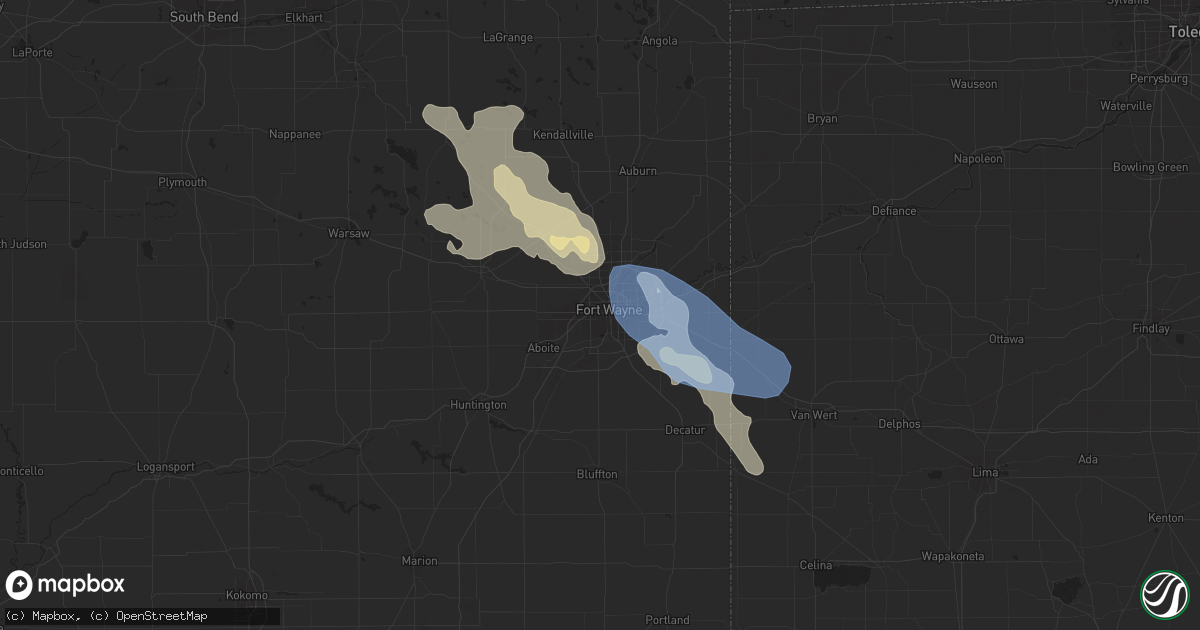
Hail Map in Fort Wayne, IN on July 5, 2022
Get this storm
July 5 map
$229
one time, instant access
Download today. No call, no setup
Keep the $229
Bought the map and want the full workflow? Apply the entire $229 to a subscription within 7 days. None of it is wasted.
Every map, not just this one
This buys you this map. Subscription and you get every map we run, in the markets you choose from a few cities to whole states to nationwide. Plus real-time alerts the moment a storm fires.
Contact data
Name, contact info, occupancy, even credit band for addresses in the footprint. You go from where it hit to who to call.
Become the source they trust
Unlimited branding weather history reports on demand. You already have the documented answer ready for the property owner, and you are the one who showed up with it.
Property data and RoofTrace estimates
Pull up any address you have got, its value and the exact code rules for that jurisdiction, straight from One Click Code. Then RoofTrace estimates the squares, pitch, and roof value, priced the way you price.
Storm reports in Fort Wayne, IN
Fort Wayne, IN
| Date | Description |
|---|---|
| 07/04/20227:59 PM CDT | Report from mping: 1-inch tree limbs broken; shingles blown off. |
| 07/04/20227:56 PM CDT | Report from mping: 1-inch tree limbs broken; shingles blown off. |
| 07/04/20227:54 PM CDT | Report from mping: trees uprooted or snapped; roof blown off. |
| 07/04/20227:50 PM CDT | Tree limbs down and estimated wind gusts to 60 mph. |
| 07/04/20227:45 PM CDT | Large tree down across monroeville rd... East of us 27. Time estimated from radar. |
| 07/04/20227:45 PM CDT | Two foot diameter tree uprooted... Blocking sagimore ct. |
| 07/04/20227:40 PM CDT | Report from mping: 3-inch tree limbs broken; power poles broken. |
| 07/04/20227:40 PM CDT | Fence blown down... Flag pole bent to the ground. |
| 07/04/20227:37 PM CDT | Trained spotter south side fort wayne... Estimated 70 mph gusts... Wall cloud forming north. |
| 07/04/20227:35 PM CDT | Trees down on south wayne ave. Time estimated from radar. |
| 07/04/20227:35 PM CDT | Large tree snapped and down on lake avenue. Time estimated from radar. |
| 07/04/20227:33 PM CDT | Large tree uprooted onto two cars on wayne street... In between union street and rockhill street. Time estimated from radar. |
| 07/04/20227:31 PM CDT | Report from mping: trees uprooted or snapped; roof blown off. |
| 07/04/20227:30 PM CDT | Multiple trees down with the largest eight to ten inches in diameter just south of smith field. Time estimated from radar. |
All States Impacted by Hail Map on July 5, 2022
All Cities Impacted by Hail Map on July 5, 2022
- Seneca, SD
- Ekalaka, MT
- Peerless, MT
- Meadow, SD
- Fort Pierre, SD
- Union Center, SD
- Cohagen, MT
- Ambrose, ND
- Fortuna, ND
- Malta, MT
- Brusett, MT
- Jordan, MT
- Roy, MT
- Grass Range, MT
- Sand Springs, MT
- Winnett, MT
- Hilger, MT
- Lewistown, MT
- Ingomar, MT
- Reserve, MT
- Williston, ND
- Wolf Point, MT
- Plentywood, MT
- Flaxville, MT
- Homestead, MT
- Richland, MT
- Froid, MT
- Dagmar, MT
- Grenora, ND
- Medicine Lake, MT
- Bainville, MT
- Larslan, MT
- Brockton, MT
- Redstone, MT
- Scobey, MT
- Poplar, MT
- Hammond, MT
- Capitol, MT
- Prairie City, SD
- Bison, SD
- Faith, SD
- Lodgepole, SD
- Reva, SD
- Dupree, SD
- Glasgow, MT
- Hinsdale, MT
- Frazer, MT
- Nashua, MT
- Miller, SD
- Saint Lawrence, SD
- Chandler, MN
- Lake Wilson, MN
- Woodstock, MN
- Pukwana, SD
- Platte, SD
- Chamberlain, SD
- Fort Thompson, SD
- Lower Brule, SD
- New Hampton, IA
- Saint Francis, SD
- Slayton, MN
- Currie, MN
- Irene, SD
- Volin, SD
- Mission Hill, SD
- Nora Springs, IA
- Floyd, IA
- Rockford, IA
- Ionia, IA
- Charles City, IA
- Rudd, IA
- Waukon, IA
- Burke, SD
- Herrick, SD
- Fairfax, SD
- Saint Charles, SD
- Bonesteel, SD
- Lime Springs, IA
- Cresco, IA
- Powers Lake, ND
- Orient, SD
- Sheridan, WY
- Kimball, SD
- Comfrey, MN
- Revere, MN
- Westbrook, MN
- Bingham Lake, MN
- Lamberton, MN
- Walnut Grove, MN
- Storden, MN
- Sanborn, MN
- Jeffers, MN
- Mountain Lake, MN
- Canton, SD
- Inwood, IA
- Alcester, SD
- Hawarden, IA
- Hudson, SD
- Terry, MT
- Lindsay, MT
- Brockway, MT
- Iona, MN
- Atkinson, NE
- Spencer, SD
- Woonsocket, SD
- Fulton, SD
- Howard, SD
- Humboldt, SD
- Montrose, SD
- Wessington Springs, SD
- Mount Vernon, SD
- Wessington, SD
- Plankinton, SD
- Canova, SD
- Mitchell, SD
- Virgil, SD
- Alpena, SD
- Canistota, SD
- Artesian, SD
- Carthage, SD
- Fedora, SD
- Hartford, SD
- Letcher, SD
- Cavour, SD
- Alexandria, SD
- Huron, SD
- Wolsey, SD
- Salem, SD
- Highmore, SD
- Biddle, MT
- Carson, ND
- Ralph, SD
- Ludlow, SD
- Nashua, IA
- Plainfield, IA
- Hollandale, WI
- Harpers Ferry, IA
- Prairie Du Chien, WI
- Luana, IA
- Postville, IA
- Monona, IA
- Wolcottville, IN
- Apple River, IL
- Warren, IL
- Sioux Rapids, IA
- Webb, IA
- Marathon, IA
- Torrington, WY
- Agar, SD
- Gettysburg, SD
- Ree Heights, SD
- Timber Lake, SD
- Holabird, SD
- Onida, SD
- Ridgeview, SD
- Isabel, SD
- Harrold, SD
- Eagle Butte, SD
- Blanchardville, WI
- Sioux Center, IA
- Orange City, IA
- Beresford, SD
- Springfield, MN
- Boyes, MT
- Stitzer, WI
- Livingston, WI
- Woodman, WI
- Mount Hope, WI
- Boscobel, WI
- Fennimore, WI
- Pierre, SD
- Hospers, IA
- Sheldon, IA
- Baldwin, IA
- Naper, NE
- Zahl, ND
- Lansing, IA
- De Soto, WI
- Harmony, MN
- Buffalo, SD
- Deerfield, WI
- Gillette, WY
- Freeman, SD
- Bridgewater, SD
- Lagrange, IN
- Topeka, IN
- Waterville, IA
- Marcus, IA
- Sutherland, IA
- Larrabee, IA
- Peterson, IA
- Cherokee, IA
- Everly, IA
- Granville, IA
- Royal, IA
- Paullina, IA
- Hartley, IA
- Primghar, IA
- Meriden, IA
- Greenville, IA
- Cleghorn, IA
- Alton, IA
- Archer, IA
- Milwaukee, WI
- Greendale, WI
- Decorah, IA
- Lynch, NE
- Edgerton, WI
- Fort Atkinson, WI
- Watauga, SD
- Akaska, SD
- Lemmon, SD
- Hoven, SD
- McLaughlin, SD
- Morristown, SD
- Lebanon, SD
- Trail City, SD
- Selby, SD
- Glencross, SD
- Keldron, SD
- McIntosh, SD
- Tolstoy, SD
- Elma, IA
- Upton, WY
- Jefferson, WI
- Linn Grove, IA
- Waukesha, WI
- New Berlin, WI
- Winthrop, IA
- White Lake, SD
- Bremen, IN
- Plymouth, IN
- Nevada, OH
- Upper Sandusky, OH
- Osage, IA
- Little Cedar, IA
- Darfur, MN
- Saint James, MN
- Madelia, MN
- Lewisville, MN
- Sleepy Eye, MN
- Hanska, MN
- Vernon Center, MN
- Lake Crystal, MN
- Garden City, MN
- Amboy, MN
- Ireton, IA
- Rock Valley, IA
- Hemingford, NE
- Ruthton, MN
- Balaton, MN
- Garnavillo, IA
- Farmersburg, IA
- Riceville, IA
- Carson, IA
- Hartington, NE
- Wynot, NE
- Delmar, IA
- Lost Nation, IA
- Lewellen, NE
- Leesburg, IN
- North Webster, IN
- Pierceton, IN
- Reading, MI
- Quincy, MI
- Garden Prairie, IL
- Burlington, IL
- Elgin, IL
- Roscoe, IL
- South Beloit, IL
- Genoa, IL
- Woodstock, IL
- Walworth, WI
- Clinton, WI
- Caledonia, IL
- Beloit, WI
- Marengo, IL
- Sycamore, IL
- Kirkland, IL
- Harvard, IL
- Union, IL
- Sharon, WI
- Poplar Grove, IL
- Clare, IL
- Hampshire, IL
- Capron, IL
- Kingston, IL
- Belvidere, IL
- Carey, OH
- Minden, IA
- Neola, IA
- McClelland, IA
- Verdigre, NE
- Urbana, IN
- North Manchester, IN
- Fordyce, NE
- Crofton, NE
- Waverly, NE
- Greenwood, NE
- Goshen, IN
- Middlebury, IN
- Millersburg, IN
- Elkhart, IN
- Knoxville, TN
- Heiskell, TN
- Powell, TN
- Coldwater, MI
- Bronson, MI
- Naponee, NE
- Wilcox, NE
- Republican City, NE
- Bloomington, NE
- Manville, WY
- Saint Paris, OH
- Urbana, OH
- Galax, VA
- Woodlawn, VA
- Rocky Top, TN
- Andersonville, TN
- Clinton, TN
- Brookville, IN
- Sunman, IN
- Baltimore, OH
- Pataskala, OH
- Pickerington, OH
- Millersport, OH
- Carroll, OH
- Douglas, WY
- Harrison, NE
- Marsland, NE
- Churubusco, IN
- Laotto, IN
- Galion, OH
- Morganton, NC
- Connelly Springs, NC
- Lebanon, TN
- Gallatin, TN
- Hillsdale, MI
- Ixonia, WI
- Watertown, WI
- Oconomowoc, WI
- Sierra Blanca, TX
- Brodhead, WI
- Orfordville, WI
- Alma, NE
- Orleans, NE
- Pauline, SC
- Jonesville, SC
- Buffalo, SC
- Liberty, MS
- Gloster, MS
- Oneida, TN
- Dorchester, IA
- Winkelman, AZ
- Evansville, WI
- Mission, SD
- Hazel Green, WI
- Cuba City, WI
- Vinton, VA
- Goodview, VA
- Glendo, WY
- Jay Em, WY
- Fort Wayne, IN
- Midwest, WY
- Hull, IA
- Montfort, WI
- Waverly, IA
- Janesville, IA
- Alliance, NE
- Lake View, IA
- Wall Lake, IA
- Crystal Lake, IL
- Camden, MI
- Milford, OH
- Georgetown, OH
- Bethel, OH
- Batavia, OH
- Camp Dennison, OH
- Cincinnati, OH
- Terrace Park, OH
- New Richmond, OH
- Loveland, OH
- Miamiville, OH
- Amelia, OH
- Hamersville, OH
- Felicity, OH
- Blountville, TN
- Brooksville, KY
- Montross, VA
- Decatur, AL
- Manilla, IN
- Rushville, IN
- Homer, IN
- Arlington, IN
- Caledonia, OH
- Lake Andes, SD
- Broadwater, NE
- Winnetoon, NE
- Creighton, NE
- Rock Rapids, IA
- Steen, MN
- Winner, SD
- Sac City, IA
- Bloomfield, NE
- McGregor, IA
- Walker, IA
- Coggon, IA
- Platteville, WI
- Belmont, WI
- Darlington, WI
- Geneva, IN
- Page, NE
- Ewing, NE
- Orchard, NE
- Debord, KY
- Inez, KY
- Warren, IN
- Norfolk, NE
- Stanton, NE
- Hartford City, IN
- Lancaster, OH
- Bremen, OH
- Lancaster, WI
- Frenchburg, KY
- Ridgeway, IA
- Martinsville, VA
- West Union, IA
- Ossian, IA
- Castalia, IA
- Spillville, IA
- Waucoma, IA
- Lawler, IA
- Fort Atkinson, IA
- Calmar, IA
- Protivin, IA
- Montpelier, IN
- Ney, OH
- Sherwood, OH
- Napoleon, OH
- Defiance, OH
- Reliance, TN
- Kimper, KY
- Canada, KY
- Fort Stockton, TX
- Chappell, NE
- Wise, VA
- Browntown, WI
- Independence, IA
- Lovington, NM
- Elizabeth, IL
- Stockton, IL
- Glenrock, WY
- Big Springs, NE
- Potter, NE
- Gurley, NE
- Sidney, NE
- Monticello, WI
- Argyle, WI
- Dalton, NE
- Mount Gilead, OH
- Benton Harbor, MI
- Hartford, MI
- Cloverdale, OH
- Fort Jennings, OH
- Harpster, OH
- Alpine, TX
- Valentine, TX
- Moravian Falls, NC
- Newland, NC
- Quincy, OH
- Sidney, OH
- Piqua, OH
- Fletcher, OH
- De Graff, OH
- Rosewood, OH
- Conover, OH
- New Glarus, WI
- Gratiot, WI
- Mount Horeb, WI
- Monroe, WI
- South Wayne, WI
- New Riegel, OH
- Alvada, OH
- Swanton, OH
- Lake Geneva, WI
- Wolcott, IN
- Reynolds, IN
- Williamsburg, KY
- Jellico, TN
- Pacolet, SC
- Page, AZ
- Emery, SD
- Van Wert, OH
- Hoagland, IN
- Monroeville, IN
- Convoy, OH
- New Haven, IN
- Rockford, OH
- Wren, OH
- Decatur, IN
- Ohio City, OH
- Willshire, OH
- Oshkosh, NE
- Ericson, NE
- Albion, IN
- Huntertown, IN
- Rewey, WI
- Mansfield, OH
- Omaha, NE
- Marion, NC
- Dunkirk, IN
- Boonville, IN
- Chandler, IN
- Osseo, MI
- Albany, WI
- Janesville, WI
- La Follette, TN
- Wellford, SC
- Startex, SC
- Spartanburg, SC
- Inman, SC
- Moore, SC
- Lyman, SC
- Woodruff, SC
- Duncan, SC
- Helenville, WI
- Fleming, CO
- Shawnee, WY
- Carthage, IN
- Benton, WI
- Shullsburg, WI
- Dubuque, IA
- East Dubuque, IL
- Scales Mound, IL
- Galena, IL
- Celina, OH
- Tiro, OH
- New Washington, OH
- Forest, OH
- Linden, WI
- Mineral Point, WI
- Westerville, OH
- Deep Gap, NC
- Ferguson, NC
- Boone, NC
- Granville, OH
- Alexandria, OH
- Concho, AZ
- Iaeger, WV
- Sergeant Bluff, IA
- Salix, IA
- Shipshewana, IN
- Leipsic, OH
- Ottawa, OH
- Miller City, OH
- Continental, OH
- Muncie, IN
- Granville, TN
- Somerset, KY
- Bloomville, OH
- Galena, OH
- Louisa, KY
- Ulysses, KY
- New Albany, OH
- Johnstown, OH
- Onarga, IL
- Ridgeville, IN
- Farmland, IN
- Manchester, KY
- Grandfalls, TX
- Hildreth, NE
- Winslow, AZ
- Sparta, NC
- Laurel Springs, NC
- Clearmont, WY
- Greer, SC
- Chuckey, TN
- Limestone, TN
- Afton, TN
- Ligonier, IN
- Wawaka, IN
- Morehead, KY
- Holdrege, NE
- Atlanta, NE
- Mason City, IA
- Northwood, IA
- Joice, IA
- Grafton, IA
- Kensett, IA
- Plymouth, IA
- Hanlontown, IA
- Manly, IA
- Burlington, WI
- Bucyrus, OH
- Thawville, IL
- Hobbs, NM
- Fairbank, IA
- Denver, IA
- Dunkerton, IA
- Hazleton, IA
- Readlyn, IA
- Jesup, IA
- White Pigeon, MI
- Bristol, IN
- Ashland, NE
- Stearns, KY
- Caryville, TN
- Jacksboro, TN
- Rogersville, TN
- Surgoinsville, TN
- Riverton, NE
- Bladen, NE
- Franklin, NE
- Upland, NE
- Campbell, NE
- Blue Hill, NE
- Inavale, NE
- Red Cloud, NE
- Guide Rock, NE
- Grove City, OH
- Purlear, NC
- Axtell, NE
- Maurice, IA
- Geddes, SD
- Armour, SD
- Gann Valley, SD
- Loomis, NE
- Bertrand, NE
- Smithfield, NE
- Springfield, SD
- Avon, SD
- Millport, AL
- Knightstown, IN
- Imperial, TX
- Axton, VA
- Yadkinville, NC
- New Leipzig, ND
- Blue River, WI
- Muscoda, WI
- Crawford, NE
- Oxford Junction, IA
- Sullivan, WI
- Johnson Creek, WI
- West Liberty, KY
- Salyersville, KY
- Rockford, IL
- Spencer, IA
- Galva, IA
- Schaller, IA
- Marathon, TX
- Cambridge, NE
- Bartley, NE
- Holbrook, NE
- Alzada, MT
- Commiskey, IN
- North Vernon, IN
- Presho, SD
- Oacoma, SD
- Larchwood, IA
- Lester, IA
- Advance, NC
- Andrews, IN
- Lagro, IN
- Adel, GA
- Sparks, GA
- Howe, IN
- Mason, OH
- Gaffney, SC
- Indianola, NE
- Gillett Grove, IA
- Richland Center, WI
- Vandalia, MI
- Jones, MI
- Marion, OH
- Lisco, NE
- Potosi, WI
- Mishawaka, IN
- Wakarusa, IN
- Roaring River, NC
- Clay, WV
- Prestonsburg, KY
- Spencer, NE
- Danville, AL
- Vinemont, AL
- Columbia City, IN
- Tulare, SD
- Hitchcock, SD
- Marion, SD
- Ryan, IA
- Lusk, WY
- Niobrara, NE
- Bridgeport, NE
- Crestline, OH
- Imperial, NE
- Benkelman, NE
- Brookston, IN
- Traphill, NC
- Hays, NC
- Stoughton, WI
- Cambridge, WI
- Lodgepole, NE
- Hicksville, OH
- Mukwonago, WI
- Constantine, MI
- Sturgis, MI
- Three Rivers, MI
- Morral, OH
- Central City, KY
- Bremen, KY
- Ashland, OH
- Seminole, TX
- Kingsley, IA
- Hinton, IA
- Avilla, IN
- Kendallville, IN
- Larwill, IN
- Kimmell, IN
- Rome City, IN
- Sitka, KY
- Flatgap, KY
- Staffordsville, KY
- Augusta, KY
- Raccoon, KY
- Pikeville, KY
- Monmouth, IA
- Wyoming, IA
- Lawndale, NC
- Gate City, VA
- Fries, VA
- Warfield, KY
- Kermit, WV
- Westby, MT
- Hettinger, ND
- Alamo, ND
- Crosby, ND
- Church Hill, TN
- Colfax, NC
- Kernersville, NC
- High Point, NC
- Greensboro, NC
- Whitehorse, SD
- Java, SD
- Onaka, SD
- Faulkton, SD
- Glenham, SD
- Meservey, IA
- Olin, IA
- Magnolia, MN
- Dayton, IA
- Allison, IA
- Rolfe, IA
- Bristow, NE
- Lowden, IA
- Leota, MN
- Titonka, IA
- Milford, IA
- Carpenter, SD
- Alexander, IA
- Ogden, IA
- North Sioux City, SD
- Ames, IA
- Edgerton, MN
- Graettinger, IA
- Lake City, IA
- Coleridge, NE
- Zearing, IA
- Clemons, IA
- Rockham, SD
- Jefferson, IA
- Rembrandt, IA
- Wheatland, IA
- Jolley, IA
- Armstrong, IA
- Laurel, NE
- Goldfield, IA
- Gayville, SD
- Wagner, SD
- Parkersburg, IA
- McCallsburg, IA
- Duncombe, IA
- Hampton, IA
- Wallingford, IA
- Willow Lake, SD
- Woolstock, IA
- Rutland, SD
- Dimock, SD
- Clarion, IA
- Magnet, NE
- Rockwell, IA
- Welton, IA
- Arlington, SD
- George, IA
- Burbank, SD
- Garner, IA
- Quasqueton, IA
- Fulda, MN
- Oran, IA
- Renner, SD
- Dumont, IA
- Whittemore, IA
- Bode, IA
- Alta Vista, IA
- Stephan, SD
- Ocheyedan, IA
- Stanley, IA
- Wesley, IA
- Williams, IA
- Rushmore, MN
- Bancroft, IA
- Stanwood, IA
- Odebolt, IA
- Ethan, SD
- Aredale, IA
- Estherville, IA
- Swea City, IA
- Rutland, IA
- Dike, IA
- Kennebec, SD
- Nunda, SD
- Vinton, IA
- Holland, IA
- Correctionville, IA
- Popejoy, IA
- Climbing Hill, IA
- Utica, SD
- Solon, IA
- Lohrville, IA
- Moville, IA
- Farnhamville, IA
- Reading, MN
- Madison, SD
- Chapin, IA
- Kenneth, MN
- Westgate, IA
- Otho, IA
- Jefferson, SD
- Iowa Falls, IA
- Mount Vernon, IA
- Aurora, SD
- Boxholm, IA
- Lisbon, IA
- Hawkeye, IA
- Buffalo Center, IA
- Robins, IA
- Stacyville, IA
- Brunsville, IA
- Stout, IA
- Gilmore City, IA
- Eagle Grove, IA
- Hardy, IA
- Calamus, IA
- Hardwick, MN
- Laurens, IA
- Brookings, SD
- Burnside, IA
- Little Rock, IA
- Masonville, IA
- Winnebago, NE
- Boone, IA
- Dewar, IA
- Fonda, IA
- Hubbard, IA
- Maynard, IA
- Ramona, SD
- Thompson, IA
- Oldham, SD
- Knierim, IA
- Morrison, IA
- Mount Auburn, IA
- Dana, IA
- Fenton, IA
- Aurelia, IA
- Delmont, SD
- Varina, IA
- Goodell, IA
- Ashton, IA
- Thornton, IA
- Bradford, IA
- Galt, IA
- Mclean, NE
- Blairsburg, IA
- Waterbury, NE
- Bristow, IA
- Lakefield, MN
- Frederika, IA
- Hurley, SD
- Moorland, IA
- Arthur, IA
- Dakota City, NE
- Kanawha, IA
- Lyons, SD
- Swisher, IA
- Nevada, IA
- Whitten, IA
- Eldora, IA
- Tyndall, SD
- Pocahontas, IA
- Saint Ansgar, IA
- Tripoli, IA
- Pickstown, SD
- Oto, IA
- Gilbert, IA
- Egan, SD
- Melvin, IA
- Hamill, SD
- Marble Rock, IA
- Randolph, NE
- Rowley, IA
- Aplington, IA
- Vermillion, SD
- Oelwein, IA
- Lehigh, IA
- Spirit Lake, IA
- Sioux Falls, SD
- West Bend, IA
- Monticello, IA
- Wellsburg, IA
- Dows, IA
- Center Junction, IA
- Fort Dodge, IA
- Hiawatha, IA
- Pierson, IA
- Clarksville, IA
- Albert City, IA
- Conrad, IA
- Arnolds Park, IA
- Ringsted, IA
- Quimby, IA
- New Providence, IA
- Carpenter, IA
- Ellsworth, MN
- Emmetsburg, IA
- McCausland, IA
- Jewell, IA
- Roland, IA
- Sloan, IA
- Story City, IA
- Gilbertville, IA
- Morley, IA
- Bronson, IA
- Fertile, IA
- Nemaha, IA
- Lu Verne, IA
- Raymond, IA
- Dante, SD
- De Smet, SD
- Bennett, IA
- Brandon, SD
- Coulter, IA
- Churdan, IA
- Danbury, IA
- Jackson, NE
- Lennox, SD
- Maskell, NE
- Stickney, SD
- Center Point, IA
- Lake Mills, IA
- Lyle, MN
- Low Moor, IA
- Mallard, IA
- Belmond, IA
- Matlock, IA
- Saint Anthony, IA
- Klemme, IA
- Sumner, IA
- Reinbeck, IA
- Geneva, IA
- Shellsburg, IA
- Blunt, SD
- Cushing, IA
- Dundee, IA
- Latimer, IA
- Merrill, IA
- Leland, IA
- Woden, IA
- Wausa, NE
- Akron, IA
- Webster City, IA
- Pipestone, MN
- Livermore, IA
- Elkton, SD
- Butte, NE
- Draper, SD
- Redfield, SD
- Tabor, SD
- Dixon, NE
- Early, IA
- McIntire, IA
- Oyens, IA
- Lawton, IA
- Thor, IA
- Alburnett, IA
- Plover, IA
- Newcastle, NE
- Kesley, IA
- Jasper, MN
- Fostoria, IA
- Burt, IA
- Anamosa, IA
- Anthon, IA
- Sanborn, IA
- Shell Rock, IA
- Scarville, IA
- Ellsworth, IA
- Dickens, IA
- Scotland, SD
- Brandon, IA
- Washta, IA
- Reliance, SD
- Hudson, IA
- Somers, IA
- Battle Creek, IA
- Clare, IA
- Clarence, IA
- Ackley, IA
- Cedar Falls, IA
- Ayrshire, IA
- Worthington, MN
- Wayne, NE
- Newell, IA
- Crystal Lake, IA
- Holland, MN
- Wilmont, MN
- Dakota City, IA
- Chatsworth, IA
- Menno, SD
- Barnum, IA
- Harcourt, IA
- Elk Point, SD
- Central City, IA
- Callender, IA
- Viborg, SD
- Lesterville, SD
- Beaver Creek, MN
- Carroll, NE
- Yankton, SD
- Colwell, IA
- Truesdale, IA
- Okoboji, IA
- Springville, IA
- Wentworth, SD
- La Porte City, IA
- Colton, SD
- Lakota, IA
- Doon, IA
- Urbana, IA
- Pomeroy, IA
- Luverne, MN
- Adrian, MN
- Bigelow, MN
- Clinton, IA
- Cedar Rapids, IA
- Union, IA
- Rockwell City, IA
- Remsen, IA
- Ida Grove, IA
- Calumet, IA
- Hubbard, NE
- Monroe, SD
- Bryant, IA
- Paton, IA
- Austinville, IA
- Lismore, MN
- Sioux City, IA
- Tea, SD
- Harrison, SD
- Worthing, SD
- Parkston, SD
- De Witt, IA
- Curlew, IA
- Osmond, NE
- Fredericksburg, IA
- Manchester, IA
- Davis, SD
- Long Grove, IA
- Tripp, SD
- Boyden, IA
- Garden City, IA
- Gowrie, IA
- Corsica, SD
- Swaledale, IA
- Holstein, IA
- Randall, IA
- Badger, IA
- Grundy Center, IA
- Alvord, IA
- Harrisburg, SD
- Belden, NE
- Gregory, SD
- Sibley, IA
- Radcliffe, IA
- Fairfax, IA
- Le Mars, IA
- Ruthven, IA
- Steamboat Rock, IA
- Martelle, IA
- Emerson, NE
- Center, NE
- Algona, IA
- Charlotte, IA
- Plainview, NE
- Volga, SD
- Flandreau, SD
- Garretson, SD
- Storm Lake, IA
- Yale, SD
- Palo, IA
- New Hartford, IA
- Grand Mound, IA
- Rowan, IA
- Hills, MN
- Arlington, IA
- Chester, SD
- Trent, SD
- Cylinder, IA
- Brewster, MN
- Crooks, SD
- Goose Lake, IA
- Dougherty, IA
- Aurora, IA
- Allen, NE
- Parker, SD
- Lake Park, IA
- Marion, IA
- Greene, IA
- Kaylor, SD
- Round Lake, MN
- Clear Lake, IA
- Rock Falls, IA
- Lake Preston, SD
- Ventura, IA
- Homer, NE
- Wakonda, SD
- Evansdale, IA
- Corwith, IA
- Kanaranzi, MN
- Orchard, IA
- Sheffield, IA
- Colman, SD
- Atkins, IA
- Vivian, SD
- South Sioux City, NE
- Saint Helena, NE
- Alta, IA
- Winfred, SD
- Bradgate, IA
- New Holland, SD
- Forest City, IA
- Ely, IA
- Westfield, IA
- Lamont, IA
- Humboldt, IA
- Chancellor, SD
- Wakefield, NE
- Stanhope, IA
- Camanche, IA
- Toddville, IA
- Havelock, IA
- Britt, IA
- Maquoketa, IA
- Valley Springs, SD
- Waterloo, IA
- Hornick, IA
- Tipton, IA
- Ponca, NE
- Iroquois, SD
- Harris, IA
- Stratford, IA
- Fairview, SD
- Baltic, SD
- Terril, IA
- Ottosen, IA
- Pilot Mound, IA
- Concord, NE
- Olivet, SD
- Vincent, IA
- Centerville, SD
- Randalia, IA
- Fayette, IA
- Lytton, IA
- Palmer, IA
- Dell Rapids, SD
- Kamrar, IA
- Auburn, IA
- Lone Rock, IA
- Renwick, IA
- Alden, IA
- Manson, IA
- Mechanicsville, IA
- Butterfield, MN
- Fort Peck, MT
- Forsyth, MT
- Powderville, MT
- Volborg, MT
- Ismay, MT
- Glendive, MT
- Circle, MT
- Bowie, MD
- Rozet, WY
- Scott, OH
- Payne, OH
- Grabill, IN
- Woodburn, IN


