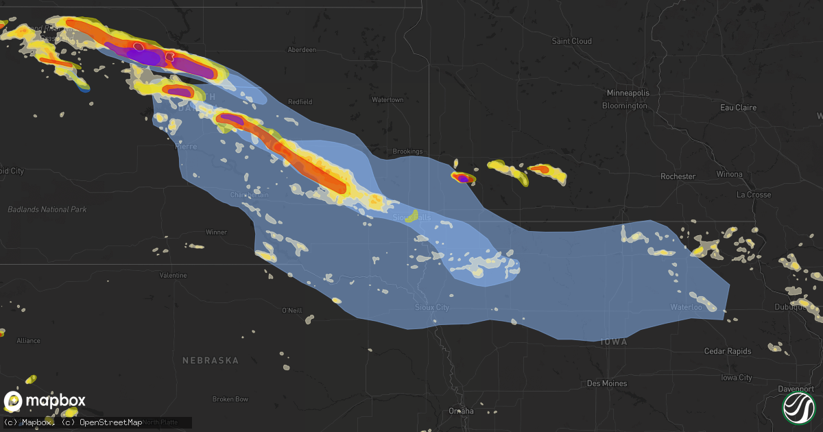
Hail Map on July 5, 2022
Get this storm
July 5 map
$229
one time, instant access
Download today. No call, no setup
Keep the $229
Bought the map and want the full workflow? Apply the entire $229 to a subscription within 7 days. None of it is wasted.
Every map, not just this one
This buys you this map. Subscription and you get every map we run, in the markets you choose from a few cities to whole states to nationwide. Plus real-time alerts the moment a storm fires.
Contact data
Name, contact info, occupancy, even credit band for addresses in the footprint. You go from where it hit to who to call.
Become the source they trust
Unlimited branding weather history reports on demand. You already have the documented answer ready for the property owner, and you are the one who showed up with it.
Property data and RoofTrace estimates
Pull up any address you have got, its value and the exact code rules for that jurisdiction, straight from One Click Code. Then RoofTrace estimates the squares, pitch, and roof value, priced the way you price.
States Impacted by Hail Map on July 5, 2022
Storm reports
Montana
| Date | Description |
|---|---|
| 07/05/20225:40 PM CDT | Report relayed via facebook. Quarter-sized hail also reported. |
| 07/05/20225:12 PM CDT | A local report indicates 1.00 inch wind near 5 SSE MALTA |
| 07/05/20224:44 PM CDT | Report via facebook of hail up to golf balls about 7 miles north of grass range. Time of event is radar estimated. |
| 07/05/20227:46 AM CDT | At 1245 AM MDT, a severe thunderstorm was located 22 miles southwest of Miles City, moving east at 20 mph. This storm is currently south of I-94. HAZARD...Golf ball size hail and 60 mph wind gusts, along with very heavy rain. SOURCE...Radar indicated. IMPACT...People and animals outdoors will be injured. Expect hail damage to roofs, siding, windows, and vehicles. Expect wind damage to roofs, siding, and trees. Locations impacted include... Hathaway, Moon Creek Ranch, Garland and Twelve Mile Dam. |
| 07/05/20227:39 AM CDT | At 1238 AM MDT, a severe thunderstorm was located 12 miles northeast of Big Timber, moving east at 30 mph. HAZARD...Golf ball size hail and 60 mph wind gusts. SOURCE...Radar indicated. IMPACT...People and animals outdoors will be injured. Expect hail damage to roofs, siding, windows, and vehicles. Expect wind damage to roofs, siding, and trees. This severe thunderstorm will remain over mainly rural areas of northeastern Stillwater, southwestern Golden Valley and northeastern Sweet Grass Counties, including the following locations... Rapelje, Halfbreed Lake Wildlife and Hailstone Wildlife Refuge.This replaces the warning previously in effect for this area. |
| 07/05/20227:00 AM CDT | At 1200 AM MDT, a severe thunderstorm was located 8 miles west of Big Timber, moving east at 30 mph. HAZARD...60 mph wind gusts and quarter size hail. SOURCE...Radar indicated. IMPACT...Hail damage to vehicles is expected. Expect wind damage to roofs, siding, and trees. This severe thunderstorm will be near... Big Timber around 1220 AM MDT. |
| 07/05/20224:35 AM CDT | At 935 PM CDT, a severe thunderstorm was located 12 miles east of Medicine Lake, or 24 miles northeast of Culbertson, moving southeast at 40 mph. HAZARD...Ping pong ball size hail and 60 mph wind gusts. SOURCE...Radar indicated. IMPACT...People and animals outdoors will be injured. Expect hail damage to roofs, siding, windows, and vehicles. Expect wind damage to roofs, siding, and trees. Locations impacted include... Bonetrail, Williston and Epping. |
| 07/05/20223:58 AM CDT | At 858 PM MDT, a severe thunderstorm was located near Lindsay, or 21 miles west of Glendive, moving east at 45 mph. HAZARD...60 mph wind gusts and quarter size hail. SOURCE...Trained weather spotters. IMPACT...Hail damage to vehicles is expected. Expect wind damage to roofs, siding, and trees. Locations impacted include... Glendive, Intake, West Glendive, Lindsay, Stipek and Forest Park. |
| 07/05/20222:59 AM CDT | At 759 PM MDT, a severe thunderstorm was located 10 miles southwest of Brockway, or 21 miles southwest of Circle, moving east at 45 mph. HAZARD...60 mph wind gusts and half dollar size hail. SOURCE...Radar indicated. IMPACT...Hail damage to vehicles is expected. Expect wind damage to roofs, siding, and trees. Locations impacted include... Circle, Lindsay, Brockway and Watkins. |
| 07/05/20222:40 AM CDT | At 739 PM MDT, severe thunderstorms were located along a line extending from 13 miles south of Redstone to 7 miles southeast of Bredette, moving east at 45 mph. HAZARD...60 mph wind gusts and quarter size hail. SOURCE...Radar indicated. IMPACT...Hail damage to vehicles is expected. Expect wind damage to roofs, siding, and trees. Locations impacted include... Plentywood, Culbertson, Medicine Lake, Bainville, Froid, Westby, Flaxville, Archer, Redstone, Reserve, Raymond, Snowden, Dagmar, Fort Kipp, Homestead, Dooley, Comertown, Navajo, Mccabe and Antelope. |
| 07/05/20222:35 AM CDT | At 735 AM MDT, severe thunderstorms were located along a line extending from 6 miles northeast of Rhame to 16 miles west of Ladner to 11 miles southwest of Camp Crook to 14 miles north of Alzada, moving southeast at 35 mph. HAZARD...60 mph wind gusts and quarter size hail. SOURCE...Radar indicated. IMPACT...Hail damage to vehicles is expected. Expect wind damage to roofs, siding, and trees. Locations impacted include... Alzada, Capitol and Albion. This replaces the warning previously in effect for this area. |
| 07/05/20221:45 AM CDT | At 644 PM MDT, a severe thunderstorm was located 9 miles southeast of Mosby, or 29 miles east of Winnett, moving east at 45 mph. HAZARD...60 mph wind gusts and quarter size hail. SOURCE...Radar indicated. IMPACT...Hail damage to vehicles is expected. Expect wind damage to roofs, siding, and trees. Locations impacted include... Jordan, Sand Springs, Cohagen, Edwards, Van Norman and Steve Fork. |
| 07/05/20221:41 AM CDT | At 641 PM MDT, severe thunderstorms were located along a line extending from near Richland to 14 miles northeast of Lustre, moving northeast at 50 mph. HAZARD...60 mph wind gusts and quarter size hail. SOURCE...Radar indicated. IMPACT...Hail damage to vehicles is expected. Expect wind damage to roofs, siding, and trees. Locations impacted include... Plentywood, Scobey, Richland, Flaxville, Archer, Port Of Whitetail, Lustre, Madoc, Bredette, Port Of Scobey, Redstone, Whitetail, Peerless, Outlook, Raymond, Daleview, Four Buttes, West Fork, Volt and Navajo. |
| 07/05/20221:41 AM CDT | At 640 PM MDT, a severe thunderstorm was located 10 miles southeast of Mosby, or 29 miles east of Winnett, moving east at 40 mph. HAZARD...60 mph wind gusts and quarter size hail. SOURCE...Radar indicated. IMPACT...Hail damage to vehicles is expected. Expect wind damage to roofs, siding, and trees. This severe thunderstorm will remain over mainly rural areas of northern Rosebud County. |
| 07/05/20221:27 AM CDT | At 626 AM MDT, a severe thunderstorm was located 22 miles northeast of Broadus, moving east at 25 mph. HAZARD...Quarter size hail. SOURCE...Radar indicated. IMPACT...Damage to vehicles is expected. Locations impacted include... Broadus and Powderville. |
| 07/05/202212:44 AM CDT | At 543 PM MDT, severe thunderstorms were located along a line extending from 17 miles northeast of Hinsdale to 16 miles northeast of Tampico to 7 miles west of St. Marie, moving east at 45 mph. HAZARD...60 mph wind gusts and quarter size hail. SOURCE...Radar indicated. IMPACT...Hail damage to vehicles is expected. Expect wind damage to roofs, siding, and trees. Locations impacted include... Richland, Lustre, St. Marie, Peerless, West Fork, Volt, Baylor, Glentana and Larslan. |
| 07/05/202212:24 AM CDT | At 523 PM MDT, severe thunderstorms were located along a line extending from 9 miles north of Sand Springs to near Mosby, moving east at 40 mph. HAZARD...60 mph wind gusts and quarter size hail. SOURCE...Radar indicated. IMPACT...Hail damage to vehicles is expected. Expect wind damage to roofs, siding, and trees. Locations impacted include... Jordan, Sand Springs, Mosby, Edwards, Brusett and Steve Fork. |
| 07/05/202212:07 AM CDT | At 506 AM MDT, severe thunderstorms were located along a line extending from 15 miles southeast of Forsyth to 10 miles south of Colstrip, moving east-southeast at 25 mph. HAZARD...Golf ball size hail and 60 mph wind gusts. SOURCE...Radar indicated. IMPACT...People and animals outdoors will be injured. Expect hail damage to roofs, siding, windows, and vehicles. Expect wind damage to roofs, siding, and trees. Locations impacted include... Ashland, Garland, Moon Creek Ranch, Twelve Mile Dam and Brandenberg.This replaces the warning previously in effect for this area. |
| 07/04/202211:42 PM CDT | At 442 AM MDT, a severe thunderstorm was located 7 miles west of Marmarth, or 10 miles southeast of Baker, moving east at 25 mph. HAZARD...60 mph wind gusts and half dollar size hail. SOURCE...Radar indicated. IMPACT...Hail damage to vehicles is expected. Expect wind damage to roofs, siding, and trees. This severe thunderstorm will be near... Marmarth around 455 AM MDT.Other locations in the path of this severe thunderstorm includeRhame. |
| 07/04/202211:23 PM CDT | At 422 PM MDT, severe thunderstorms were located along a line extending from 12 miles west of Crooked Creek Rec Area to 11 miles northeast of Winnett to 7 miles east of Grass Range, moving east at 40 mph. HAZARD...70 mph wind gusts and quarter size hail. SOURCE...Radar indicated. IMPACT...Hail damage to vehicles is expected. Expect considerable tree damage. Wind damage is also likely to mobile homes, roofs, and outbuildings. Locations impacted include... Winnett, Flatwillow, Sand Springs, U L Bend Rec Area, Edwards, Mosby, Crooked Creek Rec Area, Petrolia Lake, Steve Fork, Cat Creek and Tiegen. |
| 07/04/202211:18 PM CDT | At 417 PM MDT, a severe thunderstorm was located near Malta, moving east at 30 mph. HAZARD...60 mph wind gusts and quarter size hail. SOURCE...Trained weather spotters. IMPACT...Hail damage to vehicles is expected. Expect wind damage to roofs, siding, and trees. Locations impacted include... Malta, Saco, Bowdoin and Sleeping Buffalo. |
| 07/04/202211:14 PM CDT | At 414 AM MDT, a severe thunderstorm was located 18 miles west of Colstrip, moving east at 35 mph. HAZARD...Quarter size hail. SOURCE...Radar indicated. IMPACT...Damage to vehicles is expected. Locations impacted include... Colstrip, Forsyth, Lame Deer, Ashland, Rosebud, Hathaway, Brandenberg, Muddy Cluster, Cartersville and Northern Cheyenne Indian Reservation.This replaces the warning previously in effect for this area. |
| 07/04/202210:38 PM CDT | At 338 AM MDT, a severe thunderstorm was located 13 miles south of Custer, or 14 miles north of Hardin, moving east at 40 mph. HAZARD...60 mph wind gusts and quarter size hail. SOURCE...Radar indicated. IMPACT...Hail damage to vehicles is expected. Expect wind damage to roofs, siding, and trees. This severe thunderstorm will remain over mainly rural areas of north central Big Horn, east central Yellowstone and southeastern Treasure Counties, including the following locations... Bighorn.This replaces the warning previously in effect for this area. |
| 07/04/202210:34 PM CDT | At 334 PM MDT, severe thunderstorms were located along a line extending from near Roy to 16 miles north of Grass Range to 14 miles east of Lewistown, moving east at 35 mph. HAZARD...60 mph wind gusts and quarter size hail. SOURCE...Radar indicated. IMPACT...Hail damage to vehicles is expected. Expect wind damage to roofs, siding, and trees. Locations impacted include... Grass Range and Roy. |
| 07/04/202210:29 PM CDT | At 328 PM MDT, severe thunderstorms were located along a line extending from 9 miles northeast of Roy to 27 miles northwest of Winnett to 11 miles west of Grass Range, moving east at 40 mph. HAZARD...60 mph wind gusts and quarter size hail. SOURCE...Radar indicated. IMPACT...Hail damage to vehicles is expected. Expect wind damage to roofs, siding, and trees. Locations impacted include... Winnett, Fourchette, U L Bend Rec Area, Mosby, Crooked Creek Rec Area, Petrolia Lake, Fred Robinson Bridge, Valentine, Cat Creek and Tiegen. |
| 07/04/20229:58 PM CDT | Reported via the raws site at medicine lake. |
| 07/04/20229:55 PM CDT | At 253 AM MDT, a severe thunderstorm was located near Volborg, or 25 miles north of Broadus, moving east at 15 mph. Another potentially severe thunderstorm was located 10 miles east of Volborg. HAZARD...Golf ball size hail and 60 mph wind gusts, along with torrential rainfall. SOURCE...Radar indicated. IMPACT...People and animals outdoors will be injured. Expect hail damage to roofs, siding, windows, and vehicles. Expect wind damage to roofs, siding, and trees. Locations impacted include... Volborg and Powderville. This replaces the warning previously in effect for this area. |
| 07/04/20229:52 PM CDT | Reported relayed via facebook. |
| 07/04/20229:52 PM CDT | At 251 PM MDT, a severe thunderstorm was located 13 miles north of Lewistown, moving northeast at 35 mph. HAZARD...60 mph wind gusts and quarter size hail. SOURCE...Radar indicated. IMPACT...Hail damage to vehicles is expected. Expect wind damage to roofs, siding, and trees. Localized Flash flooding possible. Locations impacted include... Roy, Fergus, Hilger and Christina. |
| 07/04/20229:50 PM CDT | A local report indicates 1.00 inch wind near 16 NNE MCCLOUD |
| 07/04/20229:50 PM CDT | A local report indicates 60 MPH wind near 16 NNE MCCLOUD |
| 07/04/20229:43 PM CDT | At 242 AM MDT, a severe thunderstorm was located 25 miles east of Miles City, moving east at 30 mph. This storm will impact travel on highway 12. HAZARD...Golf ball size hail and 60 mph wind gusts, along with very heavy rain. SOURCE...Radar indicated. IMPACT...People and animals outdoors will be injured. Expect hail damage to roofs, siding, windows, and vehicles. Expect wind damage to roofs, siding, and trees. Locations impacted include... Ismay, Locate and Knowlton. |
| 07/04/20229:41 PM CDT | At 240 AM MDT, a severe thunderstorm was located over Huntley, or 16 miles northeast of Billings, moving east at 35 mph. HAZARD...Ping pong ball size hail and 60 mph wind gusts. SOURCE...Radar indicated. Quarter size hail was reported in the Billings Heights with this storm. IMPACT...People and animals outdoors will be injured. Expect hail damage to roofs, siding, windows, and vehicles. Expect wind damage to roofs, siding, and trees. This severe thunderstorm will be near... Ballantine and Worden around 250 AM MDT.Other locations impacted by this severe thunderstorm include PompeysPillar.This warning does not include the city of Billings.This replaces the warning previously in effect for this area. |
| 07/04/20229:20 PM CDT | A local report indicates 1.75 inch wind near MEDICINE LAKE |
| 07/04/20229:20 PM CDT | Report relayed via facebook. Nickel and dime-sized hail mixed in with quarter-sized hail. |
| 07/04/20229:08 PM CDT | At 207 AM MDT, a severe thunderstorm was located 9 miles southwest of Volborg, or 30 miles northwest of Broadus, moving northeast at 25 mph. HAZARD...Ping pong ball size hail and 60 mph wind gusts, along with very heavy rain. SOURCE...Radar indicated. IMPACT...People and animals outdoors will be injured. Expect hail damage to roofs, siding, windows, and vehicles. Expect wind damage to roofs, siding, and trees. Locations impacted include... Volborg. |
| 07/04/20228:39 PM CDT | At 138 AM MDT, a severe thunderstorm was located 20 miles northwest of Billings West End, moving east at 35 mph. HAZARD...Golf ball size hail and 60 mph wind gusts. SOURCE...Radar indicated. IMPACT...People and animals outdoors will be injured. Expect hail damage to roofs, siding, windows, and vehicles. Expect wind damage to roofs, siding, and trees. This severe thunderstorm will be near... Shepherd and Huntley around 225 AM MDT. Worden around 235 AM MDT. Ballantine around 240 AM MDT.Other locations impacted by this severe thunderstorm include Molt,Acton and Comanche.This warning does not include the city of Billings.This replaces the previous warning for this area. |
| 07/04/20228:34 PM CDT | A local report indicates 60 MPH wind near 15 SSE FLAXVILLE |
| 07/04/20228:30 PM CDT | At 129 AM MDT, a severe thunderstorm was located 10 miles southwest of Miles City, moving northeast at 15 mph. The strongest portion of this storm is expected to stay south of I-94. HAZARD...Ping pong ball size hail and 60 mph wind gusts, along with very heavy rain. SOURCE...Radar indicated. IMPACT...People and animals outdoors will be injured. Expect hail damage to roofs, siding, windows, and vehicles. Expect wind damage to roofs, siding, and trees. Locations impacted include... Miles City, Twelve Mile Dam and Strawberry Hill Recreation Area. This replaces the warning previously in effect for this area. |
| 07/04/20228:05 PM CDT | At 104 AM MDT, a severe thunderstorm was located near Flatwillow, or 16 miles south of Winnett, moving east at 40 mph. HAZARD...60 mph wind gusts and quarter size hail. SOURCE...Radar indicated. IMPACT...Hail damage to vehicles is expected. Expect wind damage to roofs, siding, and trees. Locations impacted include... Flatwillow, Mosby and Petrolia Lake. |
| 07/04/20228:00 PM CDT | A local report indicates 1.00 inch wind near 5 NW COHAGEN |
| 07/04/20227:25 PM CDT | Family member relayed quarter-sized hail report to the trained spotter providing this report. |
| 07/04/20227:15 PM CDT | Reported via facebook. |
Nebraska
| Date | Description |
|---|---|
| 07/05/20225:33 PM CDT | 61 knot gust at sidney airport. |
| 07/05/20225:33 PM CDT | 61 knot gust at sidney airport. |
| 07/05/20224:36 PM CDT | A local report indicates 59 MPH wind near 3 SSW NORFOLK |
| 07/05/20224:15 PM CDT | Trees down on highway 12 west of obert. |
| 07/05/20224:02 PM CDT | Small branches down and screen door blew off hinges. |
| 07/05/20224:00 PM CDT | A local report indicates 60 MPH wind near FORDYCE |
| 07/05/20223:50 PM CDT | Power line down. Time estimated based on radar data. |
| 07/05/20223:44 PM CDT | Tree and large limbs down on the golf course. |
| 07/05/20223:38 PM CDT | Tree down on a power line along highway 14. |
| 07/05/20223:10 PM CDT | A local report indicates 60 MPH wind near ONEILL |
| 07/05/20223:05 PM CDT | Tree limbs of 4 in diameter snapped. Winds estimated to be 50 mph. |
| 07/05/20222:39 PM CDT | Measured at flying m and d ranch mesonet site. |
| 07/05/20222:30 PM CDT | A local report indicates 65 MPH wind near BUTTE |
| 07/05/20222:26 PM CDT | A local report indicates 68 MPH wind near 7 WSW BUTTE |
| 07/05/20222:24 PM CDT | Several large tree limbs down. Time from radar. |
| 07/05/20221:48 PM CDT | A local report indicates 58 MPH wind near VALENTINE |
| 07/05/20223:12 AM CDT | At 812 PM CDT, a severe thunderstorm was located over Atlanta, or 9 miles southwest of Holdrege, moving northeast at 25 mph. HAZARD...60 mph wind gusts and quarter size hail. SOURCE...Radar indicated. IMPACT...Hail damage to vehicles is expected. Expect wind damage to roofs, siding, and trees. Locations impacted include... Holdrege. |
| 07/05/20223:02 AM CDT | At 801 PM CDT, a severe thunderstorm was located near Alma, or 20 miles south of Holdrege, moving northeast at 20 mph. HAZARD...60 mph wind gusts and half dollar size hail. SOURCE...Radar indicated. IMPACT...Hail damage to vehicles is expected. Expect wind damage to roofs, siding, and trees. This severe thunderstorm will be near... Huntley around 815 PM CDT.Other locations in the path of this severe thunderstorm includeRagan. |
| 07/05/20221:56 AM CDT | At 655 PM MDT, severe thunderstorms were located along a line extending from 12 miles south of Fort Robinson Campground to Lake Minatare Campground, moving east at 30 mph. HAZARD...60 mph wind gusts and quarter size hail. SOURCE...Radar indicated. This Severe Thunderstorm has had large, damaging hail reported in Sioux County Southwest of Agate, Nebraska earlier this evening. IMPACT...Hail damage to vehicles is expected. Expect wind damage to roofs, siding, and trees. Locations impacted include... Hemingford, Kilpatrick Lake, Box Butte Campground, Berea, Flahertys Corner, Box Butte Dam and Marsland. |
| 07/05/202212:56 AM CDT | At 555 PM MDT, a severe thunderstorm was located 10 miles southeast of Agate Bed National Monument, or 27 miles north of Scottsbluff, moving east at 35 mph. HAZARD...Tennis ball size hail and 70 mph wind gusts. SOURCE...Mesonet recorded 74mph wind gust in Goshen County at approximately 525pm. IMPACT...People and animals outdoors will be injured. Expect hail damage to roofs, siding, windows, and vehicles. Expect considerable tree damage. Wind damage is also likely to mobile homes, roofs, and outbuildings. This severe thunderstorm will remain over mainly rural areas of southern Sioux County. |
| 07/05/202212:49 AM CDT | At 549 PM MDT, a severe thunderstorm was located near Lewellen, or 12 miles southeast of Oshkosh, moving north at 35 mph. HAZARD...60 mph wind gusts and quarter size hail. SOURCE...Radar indicated. IMPACT...Hail damage to vehicles is expected. Expect wind damage to roofs, siding, and trees. Locations impacted include... Oshkosh, Lewellen, Ash Hollow State Historical Park, Eagle Gulch Campground, Ruthon, Belmar, Clear Creek State Wildlife Management Area, Intersection of Highway 27 and 9 Mile Road, Bluewater Battlefield State Historical Park, Otter Creek Campground and Windlass Hill.This includes Highway 92 between mile markers 115 and 127. |
| 07/05/202212:37 AM CDT | At 537 PM MDT, a severe thunderstorm was located 9 miles southwest of Agate Bed National Monument, or 21 miles northeast of Torrington, moving east at 30 mph. HAZARD...Golf ball size hail and 60 mph wind gusts. SOURCE...Radar indicated. IMPACT...People and animals outdoors will be injured. Expect hail damage to roofs, siding, windows, and vehicles. Expect wind damage to roofs, siding, and trees. This severe thunderstorm will remain over mainly rural areas of southern Sioux County. |
| 07/04/202211:37 PM CDT | At 437 PM MDT, a severe thunderstorm was located 9 miles northeast of The Intersection Of Highway 385 And 92, or 29 miles northwest of Oshkosh, moving northwest at 10 mph. HAZARD...60 mph wind gusts and quarter size hail. SOURCE...Radar indicated. IMPACT...Hail damage to vehicles is expected. Expect wind damage to roofs, siding, and trees. Locations impacted include... The Intersection Of Highway 385 And 92 and Broadwater. |
| 07/04/202211:30 PM CDT | At 429 PM MDT, a severe thunderstorm was located 7 miles south of Prairie Center, or 23 miles north of Torrington, moving northeast at 25 mph. HAZARD...Ping pong ball size hail and 60 mph wind gusts. SOURCE...Radar indicated. IMPACT...People and animals outdoors will be injured. Expect hail damage to roofs, siding, windows, and vehicles. Expect wind damage to roofs, siding, and trees. This severe thunderstorm will remain over mainly rural areas of west central Sioux and northeastern Goshen Counties. |
| 07/04/202210:46 PM CDT | At 346 PM CDT, severe thunderstorms were located along a line extending from 7 miles northwest of Chambers to 6 miles west of Ewing to near Orchard, moving southeast at 30 mph. HAZARD...60 mph wind gusts and quarter size hail. SOURCE...Radar indicated. IMPACT...Hail damage to vehicles is expected. Expect wind damage to roofs, siding, and trees. Locations impacted include... Ewing, Chambers, Page, Knievels Corner, Cumminsville, Four Corners, Buffalo Flats and Goose Lake State Wildlife Management Area.This includes the following highways... Highway 20 between mile markers 317 and 328. Highway 281 between mile markers 148 and 176. |
| 07/04/20229:44 PM CDT | At 242 PM CDT, severe thunderstorms were located along a line extending from 7 miles southwest of Kaylor to 8 miles northeast of Atkinson, moving southeast at 45 mph. HAZARD...60 mph wind gusts and quarter size hail. SOURCE...Radar indicated. IMPACT...Hail damage to vehicles is expected. Expect wind damage to roofs, siding, and trees. Locations impacted include... Yankton. |
| 07/04/20229:43 PM CDT | At 243 PM CDT, severe thunderstorms were located along a line extending from near Delmont to Wagner to near Spencer, moving southeast at 60 mph. HAZARD...60 mph wind gusts and penny size hail. SOURCE...Radar indicated. IMPACT...Expect damage to roofs, siding, and trees. Severe thunderstorms will be near... Dante around 250 PM CDT. Avon around 255 PM CDT.Other locations in the path of these severe thunderstorms includeTyndall, Springfield, Scotland, Tabor, Lewis And Clark StateRecreation Area, Utica, Yankton, Mayfield, Irene and Mission Hill. |
| 07/04/20229:15 PM CDT | At 215 PM CDT/115 PM MDT/, severe thunderstorms were located along a line extending from near Ainsworth to near Valentine National Wildlife Refuge to 9 miles south of Medicine Lake, moving southeast at 40 mph. HAZARD...60 mph wind gusts. SOURCE...Trained weather spotters. IMPACT...Expect damage to roofs, siding, and trees. Locations impacted include... Ainsworth, Bassett, Long Pine, Johnstown, Brownlee, Rose, Valentine National Wildlife Refuge, Elsmere, Wood Lake, Hofeld Lake, Raven, Twin Lakes State Wildlife Management Area, Willow Lake State Wildlife Management Area, Duff, Marsh Flat, Pine Glen State Wildlife Refuge, Antelope Peak, Indian Hill, Sevenmile Hill and Highway 97 crossing the North Loup River.This includes the following highways... Highway 183 between mile markers 153 and 204. Highway 20 between mile markers 221 and 263. Highway 97 between mile markers 74 and 114. Highway 83 between mile markers 159 and 193. |
| 07/04/20228:54 PM CDT | At 152 PM CDT, severe thunderstorms were located along a line extending from 6 miles southeast of Grass Ranch Colony to 13 miles west of Platte to near Dallas, moving southeast at 45 mph. HAZARD...70 mph wind gusts. SOURCE...Radar indicated. At 142 PM CDT, a 63 mph wind gust was reported 14 miles west of Platte. IMPACT...Expect considerable tree damage. Damage is likely to mobile homes, roofs, and outbuildings. Severe thunderstorms will be near... Platte around 200 PM CDT. Herrick and New Holland around 210 PM CDT. St. Charles around 215 PM CDT. Bonesteel and Geddes around 220 PM CDT. Armour around 230 PM CDT. Lake Andes around 235 PM CDT. Pickstown and Ravinia around 240 PM CDT. Wagner and Marty around 250 PM CDT.Other locations impacted by these severe thunderstorms includeFairfax and Yankton Sioux Tribal Nation. |
| 07/04/20228:40 PM CDT | Large tree limb down. |
| 07/04/20228:30 PM CDT | At 130 PM CDT, severe thunderstorms were located along a line extending from 8 miles northwest of Dallas to Millboro to 9 miles southeast of Littleburg, moving southeast at 50 mph. HAZARD...60 mph wind gusts. SOURCE...Radar indicated. IMPACT...Expect damage to roofs, siding, and trees. Locations impacted include... Ainsworth, Bassett, Springview, Long Pine, Newport, Johnstown, Norden, Wood Lake, Burton, Nets Peak, Bobcat State Wildlife Management Area, Meadville, North River Trail, Sparks, Keller Park State Recreation Area, Thomas Creek State Wildlife Management Area, Mariaville, Pine Glen State Wildlife Refuge, Antelope Peak and Mills.This includes the following highways... Highway 183 between mile markers 172 and 225. Highway 20 between mile markers 222 and 273. Highway 12 between mile markers 17 and 86. |
| 07/04/20228:16 PM CDT | Corrects previous tstm wnd dmg report from 4 w ragan. Social media report of very strong wind of unknown magnitude that took out a flag pole. Lawn furniture blown acros |
| 07/04/20228:09 PM CDT | Golf ball size at the largest in huntley. Power is out. Lots of tree limbs down. Probably 60 to 70 mph winds up. Lasted about 15 minutes. Fb report. |
| 07/04/20228:09 PM CDT | Power is out. Lots of tree limbs down. Probably 60 to 70 mph winds up. Lasted about 15 minutes. Fb report. |
| 07/04/20227:16 PM CDT | Social media report of very strong wind of unknown magnitude that took out a flag pole. Lawn furniture blown across the yard. Time estimated based on radar. |
| 07/04/20227:13 PM CDT | Report from mping: 3-inch tree limbs broken; power poles broken. Estimated 60 mph wind gust. |
| 07/04/20227:01 PM CDT | Trained spotter reports via social media and nwschat a measured 4.3 diameter hail stone. |
Indiana
| Date | Description |
|---|---|
| 07/05/20224:52 PM CDT | Tree limbs on power lines in chandler and near newburgh. |
| 07/05/20222:45 PM CDT | 12-15 inch trees downed on the north side of rushville. May have been weakened by storms last week. |
| 07/05/20221:25 PM CDT | Several large trees snapped at trunks |
| 07/05/20228:50 AM CDT | Powerlines down in water along us 24 between cr 1100 n and sr 114. |
| 07/05/20228:05 AM CDT | 2 healthy 1 foot in diameter pine trees snapped. Time estimated from radar. |
| 07/05/20228:00 AM CDT | Trees branches of 1-3 inches in diameter snapped along us-30 near crazy joes fireworks. Time estimated from radar. |
| 07/05/20224:38 AM CDT | At 938 PM EDT, a severe thunderstorm was located 7 miles west of Ohio City, moving south at 30 mph. HAZARD...60 mph wind gusts and nickel size hail. SOURCE...Radar indicated. IMPACT...Expect damage to trees and power lines. Locations impacted include... Celina, Coldwater, St. Henry, Fort Recovery, Rockford, Wabash, Mendon, Chickasaw, Montezuma, Chattanooga, Tama, Neptune and Carthagena. |
| 07/05/20224:28 AM CDT | At 927 PM EDT, a severe thunderstorm was located near Convoy, or 8 miles west of Van Wert, moving southeast at 45 mph. HAZARD...70 mph wind gusts. SOURCE...Radar indicated. IMPACT...Expect considerable tree damage. Damage is likely to mobile homes, roofs, and outbuildings. Locations impacted include... Van Wert, Convoy, Ohio City, Middlebury, Willshire, Wren, Venedocia, Elgin, Monticello, Glenmore, Dull, Abanaka, Jonestown, Rivare and Schumm. |
| 07/05/20221:59 AM CDT | At 659 PM EDT, a severe thunderstorm was located near Millersburg, or 7 miles east of Goshen, moving east at 20 mph. HAZARD...60 mph wind gusts and penny size hail. SOURCE...Radar indicated. IMPACT...Expect damage to roofs, siding, and trees. Locations impacted include... Goshen, Ligonier, Lagrange, Middlebury, Topeka, Millersburg, Honeyville, Eddy, Oliver Lake, Emma and Cosperville. |
| 07/04/202211:45 PM CDT | At 445 PM CDT, a severe thunderstorm was located over Chandler, moving southeast at 10 mph. HAZARD...Ping pong ball size hail and 60 mph wind gusts. SOURCE...Radar indicated. IMPACT...People and animals outdoors will be injured. Expect hail damage to roofs, siding, windows, and vehicles. Expect wind damage to roofs, siding, and trees. This severe thunderstorm will be near... Boonville around 505 PM CDT. |
| 07/04/202211:09 PM CDT | Several small tree branches and one larger limb of estimated 12 inches in diameter down on buckeye road. Time estimated from radar. |
| 07/04/202211:09 PM CDT | Corrects previous tstm wnd dmg report from 2 nw osceola. Several small tree branches and one larger limb of estimated 12 inches in diameter down on buckeye road. Time e |
| 07/04/202211:03 PM CDT | At 403 AM EDT, a severe thunderstorm was located near Columbia City, moving southeast at 40 mph. HAZARD...60 mph wind gusts. SOURCE...Radar indicated. IMPACT...Expect damage to roofs, siding, and trees. Locations impacted include... Fort Wayne, Columbia City, Nine Mile, Collins, Arcola, Dunfee, Rolling Hills, Coesse and Lake Everett.This includes the following highways... Interstate 469 near mile marker 2. Interstate 69 in Indiana between mile markers 299 and 313. |
| 07/04/20228:03 PM CDT | Tornado siren pole snapped and down onto a car. Time estimated from radar. |
| 07/04/20228:03 PM CDT | Roof blown off of the old premier glass building. Time estimated from radar. |
| 07/04/20227:59 PM CDT | Report from mping: 3-inch tree limbs broken; power poles broken. |
| 07/04/20227:59 PM CDT | Report from mping: 1-inch tree limbs broken; shingles blown off. |
| 07/04/20227:59 PM CDT | Report from mping: 1-inch tree limbs broken; shingles blown off. |
| 07/04/20227:56 PM CDT | Report from mping: 1-inch tree limbs broken; shingles blown off. |
| 07/04/20227:54 PM CDT | Report from mping: trees uprooted or snapped; roof blown off. |
| 07/04/20227:51 PM CDT | Report from mping: 1-inch tree limbs broken; shingles blown off. |
| 07/04/20227:50 PM CDT | Tree limbs down and estimated wind gusts to 60 mph. |
| 07/04/20227:45 PM CDT | Large tree down across monroeville rd... East of us 27. Time estimated from radar. |
| 07/04/20227:45 PM CDT | Several large trees down... Up to eight inches in diameter near besocson church. Time estimated from radar. |
| 07/04/20227:45 PM CDT | Two foot diameter tree uprooted... Blocking sagimore ct. |
| 07/04/20227:45 PM CDT | Large partially rotten tree limb broken in new haven. |
| 07/04/20227:42 PM CDT | Trees downed at us 30 and doyle rds. |
| 07/04/20227:40 PM CDT | Fence blown down... Flag pole bent to the ground. |
| 07/04/20227:40 PM CDT | Report from mping: 3-inch tree limbs broken; power poles broken. |
| 07/04/20227:37 PM CDT | Trained spotter south side fort wayne... Estimated 70 mph gusts... Wall cloud forming north. |
| 07/04/20227:35 PM CDT | Trees down on south wayne ave. Time estimated from radar. |
| 07/04/20227:35 PM CDT | Large tree snapped and down on lake avenue. Time estimated from radar. |
| 07/04/20227:33 PM CDT | Wind gusts of 55 to 60 mph. |
| 07/04/20227:33 PM CDT | Large tree uprooted onto two cars on wayne street... In between union street and rockhill street. Time estimated from radar. |
| 07/04/20227:31 PM CDT | Report from mping: trees uprooted or snapped; roof blown off. |
| 07/04/20227:30 PM CDT | Multiple trees down with the largest eight to ten inches in diameter just south of smith field. Time estimated from radar. |
Georgia
| Date | Description |
|---|---|
| 07/05/20224:23 AM CDT | At 922 PM EDT, a severe thunderstorm was located over Adel, moving northwest at 5 mph. HAZARD...60 mph wind gusts and penny size hail. SOURCE...Radar indicated. IMPACT...Expect damage to roofs, siding, and trees. Locations impacted include... Adel, Moultrie, Sparks, Omega, Norman Park, Lenox, Berlin, Cecil, Ellenton, Reed Bingham State Park, Cook Co A/P, Cool Spring, Staunton, Pineboro, Massee, Greggs, Barneyville, Pine Valley, Flat Ford and Spence Airport. |
West Virginia
| Date | Description |
|---|---|
| 07/04/20229:47 PM CDT | At 246 PM EDT, severe thunderstorms were located along a line extending from near Whitepost to Ivel, moving southeast at 45 mph. HAZARD...60 mph wind gusts. SOURCE...Radar indicated. IMPACT...Expect damage to roofs, siding, and trees. Severe thunderstorms will be near... Forest Hills around 250 PM EDT. Pikeville around 255 PM EDT. Buskirk around 300 PM EDT. Chloe around 305 PM EDT.Other locations in the path of these severe thunderstorms includeFishtrap Lake and Belcher. |
| 07/04/20229:20 PM CDT | At 220 PM EDT, severe thunderstorms were located along a line extending from near Davisport to Adele, moving southeast at 35 mph. HAZARD...60 mph wind gusts. SOURCE...Radar indicated. IMPACT...Expect damage to roofs, siding, and trees. Locations impacted include... Paintsville, West Liberty, Prestonsburg, Salyersville, Inez, Mason, Simpson, Henry, Lewis, Forest Hills, Warfield and Allen. |
North Carolina
| Date | Description |
|---|---|
| 07/05/20226:48 PM CDT | Public reported trees topped and power lines down on upper brush creek rd. Time estimated from radar. |
| 07/05/20226:40 PM CDT | Trees and power lines down in the forest city... Mooresboro and rutherfordton area. |
| 07/05/20226:38 PM CDT | Several trees down in the area. |
| 07/05/20226:25 PM CDT | A few trees reported down off cooksville rd in vale. |
| 07/05/20226:25 PM CDT | Power outage was caused by fallen trees damaging equipment. Time estimated by radar. |
| 07/05/20226:15 PM CDT | Tree down on a house at charles st. And oakwood dr. |
| 07/05/20226:13 PM CDT | Multiple trees down along harrison road. |
| 07/05/20226:11 PM CDT | One tree down in hendricks grove. |
| 07/05/20226:10 PM CDT | 911 call center reported trees down and a structural fire due to lightning on corn hill rd |
| 07/05/20226:06 PM CDT | Numerous trees reported down in marion. |
| 07/05/20226:05 PM CDT | Power outage was caused by fallen trees damaging equipment. Time estimated by radar. |
| 07/05/20226:05 PM CDT | Power outage was caused by fallen trees damaging equipment. Time estimated by radar. |
| 07/05/20226:01 PM CDT | Report from mping: 1-inch tree limbs broken; shingles blown off. |
| 07/05/20226:00 PM CDT | A few trees reported down just west of statesville. |
| 07/05/20225:59 PM CDT | Trees down near davidson-davie community college. |
| 07/05/20225:56 PM CDT | Trees down near the intersection of enola rd and hwy 18 in morganton. |
| 07/05/20225:53 PM CDT | Report from mping: trees uprooted or snapped. |
| 07/05/20225:43 PM CDT | Power outage was caused by fallen trees damaging equipment. Time estimated by radar. |
| 07/05/20225:41 PM CDT | Detached garage collapsed in oxford near the intersection of hillcrest dr and forest rd. Time estimated by radar. |
| 07/05/20225:40 PM CDT | Numerous trees reported down in mocksville. |
| 07/05/20225:36 PM CDT | Greensboro observation measured a peak wind gust of 56 kts at 636 pm. |
| 07/05/20225:34 PM CDT | A few trees reported down just north of downtown advance. |
| 07/05/20225:31 PM CDT | Greensboro observation measured a peak wind gust of 53 kts at 631 pm. |
| 07/05/20225:27 PM CDT | Public reported large oak tree blocking roadway on myers mill rd in union grove |
| 07/05/20225:26 PM CDT | Trees down across highway 68 in oak ridge. |
| 07/05/20225:20 PM CDT | Tree in roadway at north peak dr. And vancouver ct. |
| 07/05/20225:20 PM CDT | Several gusts in excess of 50 mph were measured... Including one at 59 mph. |
| 07/05/20225:18 PM CDT | Trees down near hopkins rd. |
| 07/05/20225:17 PM CDT | Trees down in the woods near a residence in kings creek. Time estimated from radar. |
| 07/05/20225:17 PM CDT | Report from mping: 3-inch tree limbs broken; power poles broken. |
| 07/05/20225:16 PM CDT | Trees and power lines down at southwest school rd. And lewisville-clemmons rd. |
| 07/05/20225:15 PM CDT | Several trees down in ferguson. |
| 07/05/20225:10 PM CDT | Report from mping: trees uprooted or snapped. |
| 07/05/20225:05 PM CDT | Trees and power lines down on shiloh church rd. |
| 07/05/20224:38 PM CDT | Numerous trees and power lines down. Power line down on a vehicle along fish dam creek rd. |
| 07/05/20224:38 PM CDT | One tree down along concord church rd. |
| 07/05/20224:32 PM CDT | Numerous trees down. |
| 07/05/20224:31 PM CDT | Large tree down on a house. |
| 07/05/20224:30 PM CDT | Thunderstorm winds blew down one tree at the intersection of hodges dairy road and pallie watlington road. |
| 07/05/20224:14 PM CDT | Thunderstorm winds blew down one tree along nunnally road south. |
| 07/05/20222:29 AM CDT | At 729 PM EDT, severe thunderstorms were located along a line extending from 5 miles west of Downtown Asheville to 12 miles southwest of Marion to 10 miles south of Morganton, moving south at 20 mph. HAZARD...60 mph wind gusts and nickel size hail. SOURCE...Radar indicated. IMPACT...Expect damage to trees and power lines. Locations impacted include... South Asheville, Hendersonville, Forest City, Rutherfordton, Arden, Black Mountain, Mills River and Fletcher. |
| 07/05/20222:24 AM CDT | At 723 PM EDT, severe thunderstorms were located along a line extending from 15 miles southwest of Hickory to 5 miles northwest of Salisbury, moving south at 15 mph. HAZARD...60 mph wind gusts and quarter size hail. SOURCE...Radar indicated. IMPACT...Minor hail damage to vehicles is expected. Expect wind damage to trees and power lines. Locations impacted include... Huntersville, Kannapolis, Downtown Concord, Salisbury, Newton, Lincolnton, Cornelius, Mooresville, Davidson and Cherryville. |
| 07/05/20222:14 AM CDT | At 713 PM EDT, severe thunderstorms were located along a line extending from near Thomasville to Linwood, moving southeast at 25 mph. HAZARD...60 mph wind gusts. SOURCE...Radar indicated. IMPACT...Expect damage to roofs, siding, and trees. Locations impacted include... Asheboro, Lexington, Randleman, North Carolina Zoo, Linwood, Ramseur, Denton, Franklinville, Staley and Gordontown. |
| 07/05/20221:54 AM CDT | At 654 PM EDT, a severe thunderstorm was located over Butner, or near Creedmoor, moving southeast at 20 mph. HAZARD...60 mph wind gusts. SOURCE...Radar indicated. IMPACT...Expect damage to roofs, siding, and trees. Locations impacted include... Raleigh, Durham, Creedmoor, Louisburg, Wake Forest, Butner, Franklinton, Kittrell, Rolesville and Youngsville. |
| 07/05/20221:43 AM CDT | At 643 PM EDT, a severe thunderstorm was located 10 miles southeast of Morganton, or 6 miles northeast of South Mountains State Park, moving southeast at 10 mph. HAZARD...60 mph wind gusts and quarter size hail. SOURCE...Radar indicated. IMPACT...Minor hail damage to vehicles is expected. Expect wind damage to trees and power lines. Locations impacted include... Cooksville, Pleasant Grove, Casar, Vale, South Mountains State Park and Belwood. |
| 07/05/20221:43 AM CDT | At 643 PM EDT, severe thunderstorms were located along a line extending from 7 miles northwest of High Point to near Bermuda Run, moving southeast at 20 mph. HAZARD...60 mph wind gusts. SOURCE...Radar indicated. IMPACT...Expect damage to roofs, siding, and trees. Locations impacted include... High Point, Lexington, Thomasville, Linwood, Arcadia, Welcome and High Rock Lake. |
| 07/05/20221:39 AM CDT | At 639 PM EDT, severe thunderstorms were located along a line extending from near Clemmons to near Kernersville to Greensboro, moving east at 30 mph. HAZARD...60 mph wind gusts. SOURCE...Greensboro Airport reported a wind gust of 61 mph. IMPACT...Expect damage to roofs, siding, and trees. Locations impacted include... Greensboro, High Point, Burlington, Graham, Randleman, Mebane, Elon, McLeansville, Archdale and Summerfield. |
| 07/05/20221:11 AM CDT | At 610 PM EDT, a severe thunderstorm was located 8 miles southeast of Newland, or 4 miles southeast of the Blue Ridge Parkway, moving southeast at 10 mph. HAZARD...60 mph wind gusts and quarter size hail. SOURCE...Radar indicated. IMPACT...Minor hail damage to vehicles is expected. Expect wind damage to trees and power lines. Locations impacted include... Linville Falls, Table Rock, Edgemont, Collettsville, Jonas Ridge, Pineola, and portions of the Blue Ride Parkway. |
| 07/05/20221:08 AM CDT | At 608 PM EDT, severe thunderstorms were located along a line extending from 9 miles southeast of Virgilina to 6 miles south of Roxboro, moving east at 25 mph. HAZARD...60 mph wind gusts. SOURCE...Radar indicated. IMPACT...Expect damage to roofs, siding, and trees. Locations impacted include... Durham, Chapel Hill, Henderson, Oxford, Hillsborough, Creedmoor, Mebane, Butner, Norlina and Kittrell. |
| 07/05/202212:51 AM CDT | At 550 PM EDT, severe thunderstorms were located along a line extending from near East Bend to 7 miles southeast of Deep Gap, moving south at 15 mph. HAZARD...60 mph wind gusts and quarter size hail. SOURCE...Radar indicated. IMPACT...Minor hail damage to vehicles is expected. Expect wind damage to trees and power lines. Locations impacted include... Lenoir, Mocksville, Taylorsville, Gamewell, Hudson, Cajah's Mountain, Bermuda Run, Stony Point, Harmony and Cedar Rock. |
| 07/05/202212:45 AM CDT | At 545 PM EDT, severe thunderstorms were located along a line extending from near Pinnacle to near East Bend to Yadkinville, moving southeast at 35 mph. HAZARD...60 mph wind gusts. SOURCE...Radar indicated. IMPACT...Expect damage to roofs, siding, and trees. Locations impacted include... Greensboro, Winston-Salem, High Point, Lexington, Thomasville, Kernersville, Clemmons, Bermuda Run, Lewisville and Summerfield. |
| 07/05/202212:40 AM CDT | At 539 PM EDT, a severe thunderstorm was located near Yanceyville, moving southeast at 35 mph. HAZARD...60 mph wind gusts. SOURCE...Radar indicated. IMPACT...Expect damage to roofs, siding, and trees. Locations impacted include... Burlington, Hillsborough, Mebane, Haw River, Lake Cammack Park & Marina, Carr, Altamahaw-Ossipee, Glen Raven, Union Ridge and Altamahaw. |
| 07/05/202212:19 AM CDT | At 518 PM EDT, severe thunderstorms were located along a line extending from near South Boston to near Ringgold, moving southeast at 20 mph. HAZARD...60 mph wind gusts. SOURCE...Radar indicated. IMPACT...Expect damage to roofs, siding, and trees. Locations impacted include... Roxboro, Concord, Stovall, Bethel Hill, Bushy Fork, Hyco Lake, Tungsten, Mayo Reservoir, Hyco Marina and Surl. |
| 07/05/202212:13 AM CDT | At 513 PM EDT, severe thunderstorms were located along a line extending from Bottom to Deep Gap, moving southeast at 15 mph. HAZARD...60 mph wind gusts and quarter size hail. SOURCE...Radar indicated. IMPACT...Hail damage to vehicles is expected. Expect wind damage to roofs, siding, and trees. Locations impacted include... North Wilkesboro... Elkin... Wilkesboro... Fairview... Jonesville... Dobson... and Boonville. |
| 07/04/202211:56 PM CDT | At 456 PM EDT, severe thunderstorms were located along a line extending from near Keeling to Cascade, moving southeast at 25 mph. HAZARD...60 mph wind gusts and quarter size hail. SOURCE...Radar indicated. IMPACT...Hail damage to vehicles is expected. Expect wind damage to roofs, siding, and trees. Locations impacted include... Danville... Yanceyville... Bethel... Providence... Mayfield... Blairs... and Milton.This includes The following Location Danville Airport. |
| 07/04/202211:55 PM CDT | At 454 PM EDT, a severe thunderstorm was located 13 miles north of Columbus, or over Lake Lure, moving east at 10 mph. HAZARD...60 mph wind gusts and nickel size hail. SOURCE...Radar indicated. IMPACT...Expect damage to trees and power lines. Locations impacted include... Lake Lure, Chimney Rock Village, Chimney Rock State Park, Bat Cave, Shingle Hollow, Green Hill and Lake Adger. |
| 07/04/202211:41 PM CDT | At 441 PM EDT, severe thunderstorms were located along a line extending from Madisonville to near Ingram, moving east at 25 mph. HAZARD...60 mph wind gusts and quarter size hail. SOURCE...Radar indicated. IMPACT...Hail damage to vehicles is expected. Expect wind damage to roofs, siding, and trees. Locations impacted include... South Boston... Halifax... Brookneal... Keysville... Charlotte Court House... Phenix... and Turbeville. |
| 07/04/20227:20 PM CDT | Numerous trees and power lines down around mint hill. |
| 07/04/20227:15 PM CDT | *** 4 inj *** 911 call center reported a tree fell down on two vehicles and caused an accident. Three people were trapped in the car by large tree limbs and four injuri |
| 07/04/20227:10 PM CDT | Trees down along dalehurst dr. |
| 07/04/20227:10 PM CDT | 911 call center reported a tree down on a house and knocked power line down on ridgeway dr |
| 07/04/20227:10 PM CDT | 911 call center reported a tree blocked roadway and brought down powerlines. Also caused a transformer to blow on s morgan st |
| 07/04/20227:10 PM CDT | Trees down along south stream blvd. |
| 07/04/20227:08 PM CDT | Trees and power lines down along yuma st. |
| 07/04/20227:05 PM CDT | Trees down along kendrick ave. |
Texas
| Date | Description |
|---|---|
| 07/05/20224:05 PM CDT | A local report indicates 63 MPH wind near 4 SSW LUBBOCK |
| 07/04/20229:15 PM CDT | At 215 PM CDT, a severe thunderstorm was located 13 miles east of Kent, and is nearly stationary. HAZARD...60 mph wind gusts and quarter size hail. SOURCE...Radar indicated. IMPACT...Hail damage to vehicles is expected. Expect wind damage to roofs, siding, and trees. This severe thunderstorm will remain over mainly rural areas of southwestern Reeves and northeastern Jeff Davis Counties.This includes the following highways... Interstate 10 between mile markers 186 and 197. Interstate 20 between mile markers 0 and 1. |
| 07/04/20227:44 PM CDT | West texas mesonet report |
Wisconsin
| Date | Description |
|---|---|
| 07/05/20225:50 PM CDT | Nickel to quarter sized hail. |
| 07/05/20225:44 PM CDT | Report of quarter size and slightly larger hail. |
| 07/05/20225:34 PM CDT | Estimated at a little over an inch. Via citgo gas station. |
| 07/05/20225:30 PM CDT | Corrects time of previous hail report from orfordville. Report of quarter size and slightly larger hail. |
| 07/05/20225:30 PM CDT | Corn laying flat in field due to wind damage. |
| 07/05/20225:11 AM CDT | At 1011 PM CDT, severe thunderstorms were located along a line extending from near Edmore to Canton, moving east at 40 mph. HAZARD...60 mph wind gusts. SOURCE...Radar indicated. IMPACT...Expect damage to roofs, siding, and trees. Locations impacted include... Dubuque, Maquoketa, Galena, Asbury, Bellevue, East Dubuque, Warren, Peosta, Preston, Hanover, Elizabeth, Woodbine, Sabula, Miles, Andrew, Scales Mound, Apple River, La Motte, Menominee and Springbrook. |
| 07/05/20223:40 AM CDT | At 839 PM CDT, a severe thunderstorm was located over Guilford, or near Galena, moving southeast at 25 mph. HAZARD...60 mph wind gusts. SOURCE...Radar indicated. IMPACT...Expect damage to roofs, siding, and trees. Locations impacted include... Lena, Stockton, Warren, Pearl City, Woodbine, Scales Mound, Apple River, Winslow, Council Hill, Nora, Schapville, Loran, Guilford, Kent, Waddams Grove, Canyon Camp, Lake Le-Aqua- na State Park, Willow, Apple River Canyon State Park and Stockton Airport. |
| 07/05/20221:58 AM CDT | At 658 PM CDT, a severe thunderstorm was located 7 miles north of Bloomington, or 12 miles east of Prairie Du Chien, moving east at 25 mph. HAZARD...60 mph wind gusts and penny size hail. SOURCE...Radar indicated. IMPACT...Expect damage to roofs, siding, and trees. This severe thunderstorm will be near... Lancaster and Fennimore around 730 PM CDT. Platteville around 800 PM CDT.Other locations impacted by this severe thunderstorm include Preston,Arthur, Montfort, Werley, Mount Ida and Livingston. |
| 07/05/20221:24 AM CDT | At 623 PM CDT, a severe thunderstorm was located over Monona, or 11 miles west of Prairie Du Chien, moving southeast at 35 mph. HAZARD...60 mph wind gusts and quarter size hail. SOURCE...Radar indicated. IMPACT...Hail damage to vehicles is expected. Expect wind damage to roofs, siding, and trees. This severe thunderstorm will be near... Farmersburg around 630 PM CDT. McGregor and Marquette around 635 PM CDT. Garnavillo around 645 PM CDT. Guttenberg around 700 PM CDT.Other locations impacted by this severe thunderstorm include Volney,Spook Cave Campground, Giard, Watson, Bridgeport, National and PatchGrove. |
| 07/05/20221:12 AM CDT | At 611 PM CDT, a severe thunderstorm was located over Mineral Point, moving southeast at 20 mph. HAZARD...60 mph wind gusts and quarter size hail. SOURCE...Radar indicated. IMPACT...Hail damage to vehicles is expected. Expect wind damage to roofs, siding, and trees. Locations impacted include... Mineral Point, Blanchardville, Linden, Waldwick, Fayette, Lamont, Hollandale, Yellowstone Lake St Park, Calamine and Jonesdale. |
| 07/05/202212:37 AM CDT | At 537 PM CDT, severe thunderstorms were located along a line extending from near Monticello to 6 miles south of Orfordville, moving southeast at 15 mph. HAZARD...60 mph wind gusts and penny size hail. SOURCE...Radar indicated. IMPACT...Expect damage to roofs, siding, and trees. Locations impacted include... Rockford, Beloit, Loves Park, Machesney Park, Roscoe, South Beloit, Rockton, Durand, Harrison, Shirland and Lake Summerset.Including the following interstate... I-90 between mile markers 0 and 14. This includes...Rock Cut State Park, Rock Valley College, Rockford Rivets Baseball, and Rockford Speedway. |
| 07/05/202212:22 AM CDT | At 522 PM CDT, a severe thunderstorm was located near Albany, or near Evansville, moving southeast at 15 mph. HAZARD...60 mph wind gusts and quarter size hail. SOURCE...Radar indicated. IMPACT...Hail damage to vehicles is expected. Expect wind damage to roofs, siding, and trees. Locations impacted include... Janesville, Brodhead, Orfordville, Footville, Newark, Magnolia, Hanover, Leyden and Afton. |
Illinois
| Date | Description |
|---|---|
| 07/05/20226:10 PM CDT | [delayed report] photo of tree damage at emricson park... South street. Time estimated based on radar. |
| 07/05/20226:00 PM CDT | Tree snapped near shirland road and moody road east of shirland. Tree blocking roadway. Tree appeared to be dead. Time estimated by radar. |
| 07/05/20227:36 AM CDT | At 1236 AM CDT, a severe thunderstorm was located over West Chicago, moving southeast at 40 mph. HAZARD...60 mph wind gusts. SOURCE...Radar indicated. IMPACT...Expect damage to roofs, siding, and trees. Locations impacted include... Chicago, Aurora, Joliet, Naperville, Cicero, Bolingbrook, Orland Park, Tinley Park, Oak Lawn, Berwyn, Wheaton, Downers Grove, Romeoville, Plainfield, Calumet City, Woodridge, Chicago Heights, Chicago Lawn, Englewood and South Shore.Including the following interstates... I-55 between mile markers 257 and 289. I-57 between mile markers 339 and 358. I-80 between mile markers 130 and 155. I-88 between mile markers 121 and 133. I-90 between mile markers 101 and 107. I-94 between mile markers 56 and 74. I-294 between mile markers 56 and 74. I-355 between mile markers 1 and 22.This includes... Argonne National Laboratory, Brookfield Zoo,SeatGeek Stadium, University of Chicago, University of St. Francis,Windy City Thunderbolts Baseball, Benedictine University, College ofDuPage, Hollywood Casino Amphitheatre, Joliet Slammers Baseball,Lewis University, Moraine Valley Community College, Morton Arboretum,Prairie State College, South Suburban College, Museum of Science andIndustry, and North Central College. |
| 07/05/20227:14 AM CDT | At 1213 AM CDT, NWS meteorologists were tracking numerous severe thunderstorms from Huntley to Evanston, all moving southeast at 35 mph. HAZARD...60 mph wind gusts. SOURCE...Radar indicated. IMPACT...Expect damage to roofs, siding, and trees. Locations impacted include... Chicago, Evanston, Skokie, Des Plaines, Mount Prospect, Glenview, Ohare Airport, Wheeling, Park Ridge, Northbrook, Niles, West Ridge, Lake View, Irving Park, Lincoln Park, Wilmette, Norridge, Edgewater, Rogers Park and Albany Park.Including the following interstates... I-90 between mile markers 75 and 84. I-94 between mile markers 26 and 45. I-294 between mile markers 26 and 45.This includes... Loyola University, Oakton Community College,Northeastern Illinois University, Northwestern University, andWrigley Field. |
| 07/05/20226:00 AM CDT | At 1100 PM CDT, severe thunderstorms were located along a line extending from Lynn Center to near Disco, moving southeast at 50 mph. HAZARD...60 mph wind gusts. SOURCE...Radar indicated. IMPACT...Expect damage to roofs, siding, and trees. Severe thunderstorms will be near... Oneida and Altona around 1120 PM CDT.Other locations in the path of these severe thunderstorms includeVictoria and Williamsfield.This includes Interstate 74 between mile markers 34 and 67. |
| 07/05/20223:06 AM CDT | At 805 PM CDT, severe thunderstorms were located along a line extending from near Maple Park to Campton Hills to Elgin, moving southeast at 35 mph. HAZARD...60 mph wind gusts and penny size hail. SOURCE...Radar indicated. IMPACT...Expect damage to roofs, siding, and trees. Locations impacted include... Aurora, Naperville, Elgin, Schaumburg, Wheaton, Hoffman Estates, Bartlett, Streamwood, Carol Stream, Hanover Park, Addison, Glendale Heights, St. Charles, Woodridge, Glen Ellyn, West Chicago, Batavia, Geneva, Campton Hills and Roselle.This includes...Schaumburg Boomers Baseball, Aurora University, Benedictine University, College of DuPage, DuPage County Fairgrounds, Fermilab, IL Math and Science Academy, Kane County Cougars Ballpark, Waubonsee Community College, Wheaton College, and North Central College. |
| 07/05/20222:14 AM CDT | At 712 PM CDT, severe thunderstorms winds were located along a line extending from near Woodstock to near Herbert, moving southeast at 30 mph. Strong outflow winds are also occurring well ahead of the thunderstorms. HAZARD...60 mph wind gusts. SOURCE...Radar indicated. IMPACT...Expect damage to roofs, siding, and trees. Locations impacted include... Elgin, Bartlett, Crystal Lake, Carpentersville, St. Charles, Algonquin, Lake in the Hills, Huntley, Sycamore, Campton Hills, Genoa, South Elgin, Cary, Pingree Grove, Gilberts, West Dundee, Hampshire, Fox River Grove, Cortland and Barrington Hills.Including the following interstate... I-90 between mile markers 40 and 56. This includes...Elgin Community College and Mchenry County College. |
| 07/05/20221:43 AM CDT | At 643 PM CDT, a severe thunderstorm was located over Poplar Grove, moving southeast at 25 mph. HAZARD...60 mph wind gusts and penny size hail. SOURCE...Radar indicated. IMPACT...Expect damage to roofs, siding, and trees. Locations impacted include... Crystal Lake, Lake in the Hills, Belvidere, Woodstock, Huntley, Marengo, Poplar Grove, Hampshire, Candlewick Lake, Lakewood, Capron, Timberlane, Union, Garden Prairie and Ridgefield.Including the following interstate... I-90 between mile markers 23 and 41. This includes...Boone County Fairgrounds and Mchenry County College. |
| 07/05/202212:53 AM CDT | At 553 PM CDT, severe thunderstorms were located along a line extending from Sharon to near Harvard, moving east at 5 mph. HAZARD...60 mph wind gusts and nickel size hail. SOURCE...Radar indicated. IMPACT...Expect damage to roofs, siding, and trees. Locations impacted include... McHenry, Woodstock, Harvard, Wonder Lake, Hebron, Bull Valley, Chemung and Greenwood.This includes...Mchenry County Fairgrounds. |
| 07/05/202212:33 AM CDT | At 533 PM CDT, a severe thunderstorm was located near Monticello, or 7 miles north of Monroe, moving southeast at 25 mph. HAZARD...60 mph wind gusts and quarter size hail. SOURCE...Radar indicated. IMPACT...Hail damage to vehicles is expected. Expect wind damage to roofs, siding, and trees. Locations impacted include... Monroe, Brodhead, New Glarus, Monticello, Newark, Juda and Avon. |
| 07/04/202211:48 PM CDT | Several large tree branches down... Report relayed from social media. Time estimated from radar. |
| 07/04/202211:40 PM CDT | 4 inch diameter tree branch down... Report relayed from social media. Time estimated from radar. |
| 07/04/202211:35 PM CDT | Report from mping: 3-inch tree limbs broken. |
| 07/04/202211:02 PM CDT | Large tree down... Report from social media. Time estimated from radar. |
| 07/04/202211:01 PM CDT | 1-inch tree limbs broken; shingles blown off. |
| 07/04/202211:00 PM CDT | Corrects previous tstm wnd dmg report from sterling. Several large tree branches down... Report relayed from social media. Time estimated from radar. |
| 07/04/202210:57 PM CDT | Large tree down... Report relayed from social media. Time estimated from radar. |
| 07/04/202210:42 PM CDT | Report of tree down along 76th street. Time estimated by radar. |
| 07/04/202210:38 PM CDT | Report of tree down on rush street south of hanover il... Relayed by law enforcement. Time estimated by radar. |
| 07/04/20229:20 PM CDT | Report of several tree limbs down. Damage was estimated to have occurred between 9:15 pm and 9:30 pm. |
| 07/04/20228:12 PM CDT | [delayed report] large tree uprooted. Time estimated based on radar. |
| 07/04/20228:12 PM CDT | [delayed report] several 5 inch diameter tree limbs down around town. Time estimated based on radar. |
| 07/04/20227:45 PM CDT | 1 inch hail reported just south of genoa. Time estimated by radar. |
| 07/04/20227:35 PM CDT | Small tree snapped at base... Blocking melms road northwest of hampshire. Relayed via spotter network. Time estimated by radar. |
| 07/04/20227:08 PM CDT | Tree branches downed in belvidere. 40-ft tree downed onto power lines near lincoln avenue and appleton road. Time estimated by radar. |
Iowa
| Date | Description |
|---|---|
| 07/05/20226:54 PM CDT | 12 inch diameter trees and power lines down. Few trees uprooted. Time estimated from radar. |
| 07/05/20226:50 PM CDT | A local report indicates 1.00 inch wind near KENSETT |
| 07/05/20226:47 PM CDT | 61 mph gust. 2-4 in diameter limbs down. |
| 07/05/20226:38 PM CDT | Winds estimated to be 60 to 70 mph at this location... With numerous branches up to 3 inches in diameter downed. |
| 07/05/20226:30 PM CDT | The clay county em reported many downed trees just west of royal... Iowa. |
| 07/05/20226:15 PM CDT | A local report indicates 64 MPH wind near 2 W ALGONA |
| 07/05/20226:14 PM CDT | A local report indicates 60 MPH wind near 4 E SANBORN |
| 07/05/20226:00 PM CDT | A local report indicates 58 MPH wind near 2 WNW GRUVER |
| 07/05/20225:39 PM CDT | Personal weather station. |
| 07/05/20225:30 PM CDT | A local report indicates 64 MPH wind near 6 E ROCK RAPIDS |
| 07/05/20224:59 PM CDT | From a personal weather station near hartley. |
| 07/05/20224:52 PM CDT | Asos station ksux sioux gateway airport. |
| 07/05/20224:51 PM CDT | A trained spotter reported many snapped power poles... A 3 foot diameter tree down... And many 2 - 4 inch diameter branches down. |
| 07/05/202210:25 AM CDT | Delayed report. Several tree branches down on property. Time estimated from radar. |
| 07/05/20225:54 AM CDT | At 1054 PM CDT, severe thunderstorms were located along a line extending from near Miles to Fishermans Corner to Viola, moving east at 35 mph. HAZARD...60 mph wind gusts. SOURCE...Trained weather spotters. IMPACT...Expect damage to roofs, siding, and trees. Locations impacted include... Davenport, Moline, Rock Island, Bettendorf, Clinton, East Moline, Sterling, Kewanee, Rock Falls, Morrison, Cambridge, Silvis, Geneseo, DeWitt, Milan, Colona, Camanche, Le Claire, Coal Valley and Fulton. |
| 07/05/20225:51 AM CDT | At 1051 PM CDT, severe thunderstorms were located along a line extending from near Winslow to near Loran to Teeds Grove, moving east at 45 mph. HAZARD...60 mph wind gusts. SOURCE...Radar indicated. IMPACT...Expect damage to roofs, siding, and trees. Locations impacted include... Freeport, Mount Carroll, Savanna, Lena, Stockton, Lanark, Milledgeville, Fairhaven, Pearl City, Shannon, Cedarville, Davis, Sabula, Chadwick, Dakota, German Valley, Winslow, Rock City, Ridott and Nora. |
| 07/05/20225:49 AM CDT | At 1049 PM CDT, severe thunderstorms were located along a line extending from near Montrose to near La Belle to 7 miles east of Atlanta, moving southeast at 60 mph. HAZARD...60 mph wind gusts. SOURCE...Radar indicated. IMPACT...Expect damage to roofs, siding, and trees. Locations impacted include... Keokuk, Hamilton, Warsaw, Montrose, Augusta, Wayland, Bowen, West Point, Alexandria, St. Francisville, Winchester, Plymouth, Denver, Elvaston, Basco, Bentley, Keokuk Airport, Gregory Landing, Tioga and Stillwell. |
| 07/05/20225:31 AM CDT | At 1031 PM CDT, severe thunderstorms were located along a line extending from Gingle Corners to Denmark, moving southeast at 60 mph. HAZARD...60 mph wind gusts. SOURCE...Radar indicated. IMPACT...Expect damage to roofs, siding, and trees. Locations impacted include... Burlington, Macomb, Fort Madison, Monmouth, Aledo, Carthage, Oquawka, Nauvoo, Bushnell, West Burlington, Burgess, New London, Mediapolis, Colchester, La Harpe, Roseville, Viola, Dallas City, Danville and Stronghurst. |
| 07/05/20225:07 AM CDT | At 1007 PM CDT, severe thunderstorms were located along a line extending from near Monmouth to Lowden to near Columbus City, moving southeast at 45 mph. HAZARD...60 mph wind gusts. SOURCE...Radar indicated. IMPACT...Expect damage to roofs, siding, and trees. Locations impacted include... Davenport, Moline, Rock Island, Bettendorf, Clinton, Muscatine, East Moline, Maquoketa, Durant, Silvis, Eldridge, DeWitt, Milan, Camanche, Le Claire, Coal Valley, West Liberty, Wilton, Hampton and Port Byron. |
| 07/05/20224:24 AM CDT | At 924 PM CDT, a severe thunderstorm was located near Mount Vernon, or 9 miles northwest of Mechanicsville, moving southeast at 50 mph. HAZARD...60 mph wind gusts. SOURCE...Radar indicated. IMPACT...Expect damage to roofs, siding, and trees. Locations impacted include... Tipton, Durant, Mechanicsville, Stanwood, Solon, Lowden, Wyoming, Oxford Junction, Bennett, Buchanan, Clarence, Cedar Valley, Massillon Park, Cedar Bluff, Oxford Mills, Bennett Park, Sutliff, Sunbury, Cedar Valley Park and Tipton Matthews Airport. |
| 07/05/20224:00 AM CDT | At 900 PM CDT, a severe thunderstorm was located over Troy Mills, or 14 miles southeast of Independence, moving east at 40 mph. HAZARD...60 mph wind gusts. SOURCE...Radar indicated. IMPACT...Expect damage to roofs, siding, and trees. Locations impacted include... Cedar Rapids, Anamosa, Marion, Hiawatha, Mount Vernon, Monticello, Robins, Center Point, Lisbon, Urbana, Central City, Springville, Walker, Olin, Alburnett, Coggon, Hopkinton, Wyoming, Ryan and Bertram. |
| 07/05/20223:24 AM CDT | At 824 PM CDT, severe thunderstorms were located along a line extending from 6 miles northwest of Tripoli to near Reinbeck, moving east at 50 mph. HAZARD...60 mph wind gusts. SOURCE...Radar indicated. IMPACT...Expect damage to roofs, siding, and trees. Locations impacted include... Waterloo, Cedar Falls, Waverly, Evansdale, Jesup, La Porte City, Hudson, Sumner, Denver, Reinbeck, Tripoli, Shell Rock, Dike, Elk Run Heights, Waterloo Municipal Airport, Crossroads Mall, Uni-Dome And McLeod Center, Janesville, Washburn and Dunkerton.This includes Interstate 380 between mile markers 56 and 73. |
| 07/05/20223:11 AM CDT | At 811 PM CDT, severe thunderstorms were located along a line extending from near Frederika to near Waterloo Municipal Airport to Lincoln, moving east at 50 mph. HAZARD...60 mph wind gusts. SOURCE...Radar indicated. IMPACT...Expect damage to roofs, siding, and trees. Locations impacted include... Independence, Jesup, Fairbank, Winthrop, Hazleton, Quasqueton, Lamont, Brandon, Rowley, Aurora, Stanley, Lime Creek County Park, Winthrop Golf Course, Wapsipinicon Golf Course, Fontana County Park, Littleton, Monti, Buchanan County Fairgrounds, Otterville and Independence Airport. |
| 07/05/20223:08 AM CDT | At 807 PM CDT, severe thunderstorms were located along a line extending from Nashua to 7 miles south of Shell Rock, moving east at 40 mph. HAZARD...60 mph wind gusts. SOURCE...Radar indicated. IMPACT...Expect damage to roofs, siding, and trees. Severe thunderstorms will be near... Maynard around 855 PM CDT. Fayette around 900 PM CDT. Arlington around 910 PM CDT.Other locations impacted by these severe thunderstorms includeHighway 93 And County W 14, Highway 93 And County V 68, Volga RiverState Park, Wadena, Randalia, Highways 3 And 187 and County Road W 45And 187. |
| 07/05/20222:40 AM CDT | At 739 PM CDT, severe thunderstorms were located along a line extending from near St. Ansgar to near Marble Rock, moving east at 40 mph. HAZARD...60 mph wind gusts. SOURCE...Trained weather spotters and automated weather observation systems. IMPACT...Expect damage to roofs, siding, and trees. Severe thunderstorms will be near... Nashua around 810 PM CDT. Riceville around 815 PM CDT. Fredericksburg and Lime Springs around 835 PM CDT. Cresco around 850 PM CDT.Other locations impacted by these severe thunderstorms include VernonSprings County Park, Vernon Springs, Bradford, Chickasaw, CountyRoads V 58 And A 46, New Hampton Airport and County Roads B 28 And V18. |
| 07/05/20222:31 AM CDT | At 730 PM CDT, severe thunderstorms were located along a line extending from 7 miles east of Sheffield to 11 miles northeast of Roland, moving east at 40 mph. HAZARD...60 mph wind gusts. SOURCE...Radar indicated. IMPACT...Expect damage to roofs, siding, and trees. Locations impacted include... Waterloo, Cedar Falls, Waverly, Iowa Falls, Hampton, Eldora, Grundy Center, Allison, Evansdale, Jesup, La Porte City, Hudson, Sumner, Parkersburg, Denver, Reinbeck, Ackley, Clarksville, Tripoli and Shell Rock.This includes Interstate 380 between mile markers 57 and 73. |
| 07/05/20221:56 AM CDT | At 656 PM CDT, severe thunderstorms were located along a line extending from near Belmond to 7 miles west of Big Wall Lake to 11 miles southeast of Fort Dodge to near Gowrie, moving east at 45 mph. HAZARD...60 mph wind gusts. SOURCE...Radar indicated. IMPACT...Expect damage to roofs, siding, and trees. Locations impacted include... Fort Dodge, Webster City, Iowa Falls, Hampton, Garner, Clarion, Eldora, Dakota City, Humboldt, Eagle Grove, Belmond, Britt, Lake City, Ackley, Jewell Junction, Sheffield, Rockwell, Gowrie, Fort Dodge Regional Airport and Big Wall Lake.This includes Interstate 35 between mile markers 127 and 191. |
| 07/05/20221:21 AM CDT | At 620 PM CDT, severe thunderstorms were located along a line extending from near Orleans to near Fostoria to near Everly, moving southeast at 45 mph. HAZARD...60 mph wind gusts. SOURCE...Radar indicated. IMPACT...Expect damage to roofs, siding, and trees. Severe thunderstorms will be near... Spencer In Clay County, Royal and Fostoria around 625 PM CDT. Superior and Greenville around 635 PM CDT. Terril around 640 PM CDT. Webb around 645 PM CDT.Other locations impacted by these severe thunderstorms includeDickens, Gillett Grove and Rossie. |
| 07/05/20221:08 AM CDT | At 607 PM CDT, severe thunderstorms were located along a line extending from 8 miles west of Algona to near Pocahontas to 6 miles north of North Twin Lake to 7 miles east of Sac City, moving southeast at 45 mph. HAZARD...60 mph wind gusts. SOURCE...Radar indicated. IMPACT...Expect damage to roofs, siding, and trees. Locations impacted include... Fort Dodge, Webster City, Algona, Garner, Clarion, Rockwell City, Dakota City, Humboldt, Eagle Grove, Belmond, Britt, Lake City, Manson, Jewell Junction, Gowrie, Elm Lake, North Twin Lake, Fort Dodge Regional Airport, Big Wall Lake and Eagle Lake.This includes Interstate 35 between mile markers 136 and 154. |
| 07/05/202212:36 AM CDT | At 535 PM CDT, a line of severe thunderstorms were located 6 miles southwest of Sherburn, or 8 miles east of Jackson In Jackson County, moving east at 40 mph. HAZARD...60 mph wind gusts. SOURCE...Law enforcement. IMPACT...Expect damage to roofs, siding, and trees. Locations impacted include... Fairmont, Sherburn, Truman, Trimont, Welcome, Ceylon, Iowa Lake, Okamanpedan Lake, Granada, East Chain, Northrop and Dunnell. |
| 07/05/202212:12 AM CDT | At 510 PM CDT, severe thunderstorms were located along a line extending from 6 miles west of Blue Mounds State Park to near Worthington to near Harris, moving east at 45 mph. HAZARD...70 mph wind gusts. SOURCE...Radar indicated. IMPACT...Expect considerable tree damage. Damage is likely to mobile homes, roofs, and outbuildings. Severe thunderstorms will be near... Round Lake around 520 PM CDT. Leota around 530 PM CDT.Damaging winds are occurring well behind the main line of storms. Winds at Sioux Falls airport gusted over 60 mph for over 30 minutes.Other locations in the path of these severe thunderstorms includeEllsworth, Lismore, Lakefield, Adrian, Wilmont, Kilen Woods StatePark, Jackson In Jackson County, Worthington and Brewster. |
| 07/04/202211:10 PM CDT | At 409 PM CDT, severe thunderstorms were located along a line extending from near Jasper to near Rock Rapids to near Hudson, moving east at 45 mph. HAZARD...70 mph wind gusts and quarter size hail. SOURCE...Radar indicated. IMPACT...Hail damage to vehicles is expected. Expect considerable tree damage. Wind damage is also likely to mobile homes, roofs, and outbuildings. Severe thunderstorms will be near... Rock Rapids, Hull and Doon around 415 PM CDT. George and Ellsworth around 420 PM CDT. Boyden, Maurice and Matlock around 425 PM CDT. Orange City and Little Rock around 430 PM CDT. Sheldon, Sibley, Alton, Ashton and Leota around 435 PM CDT. Adrian, Hospers and Lismore around 440 PM CDT. Sanborn, Wilmont and Granville around 445 PM CDT. Ocheyedan, Rushmore, Melvin and Archer around 450 PM CDT.Other locations impacted by these severe thunderstorms includeKenneth, Moneta, Calumet, Kinbrae, Dundee, Steen, Magnolia andBigelow. |
| 07/04/202210:40 PM CDT | 4-6 diameter tree branch snapped. Report relayed by social media. Time estimated from radar. |
| 07/04/202210:40 PM CDT | 8-10 inch diameter tree limb down. Time estimated from radar. |
| 07/04/202210:39 PM CDT | Large tree down at the genesis medical center... Time estimated by radar. Report relayed via social media. |
| 07/04/202210:35 PM CDT | Large tree down on a vehicle on the west side of davenport. Report relayed via social media. Time estimated from radar. |
| 07/04/202210:25 PM CDT | Corrects previous tstm wnd dmg report from 1 s salem. Delayed report. Several tree branches down on property. Time estimated from radar. |
| 07/04/202210:19 PM CDT | At 319 PM CDT, severe thunderstorms were located along a line extending from 7 miles west of Colton to near Chancellor to near Mayfield, moving east at 50 mph. HAZARD...70 mph wind gusts and ping pong ball size hail. SOURCE...Radar indicated. IMPACT...People and animals outdoors will be injured. Expect hail damage to roofs, siding, windows, and vehicles. Expect considerable tree damage. Wind damage is also likely to mobile homes, roofs, and outbuildings. Severe thunderstorms will be near... Tea, Lennox, Chancellor and Davis around 325 PM CDT. Viborg around 330 PM CDT. Harrisburg, Centerville, Worthing and Lyons around 335 PM CDT.Other locations in the path of these severe thunderstorms includeSioux Falls, Crooks, Baltic, Dell Rapids, Lake Alvin State RecreationArea, Ellis, Renner, Canton, Beresford, Brandon, Newton Hills StatePark, Garretson, Inwood, Sherman, Fairview, Palisades State Park,Corson, Rowena, Valley Springs, Hudson and Alvord. |
| 07/04/202210:10 PM CDT | Several trees down at country club on east side of town. Time estimated from radar. |
| 07/04/202210:00 PM CDT | Power lines down south of tipton. Time estimated. |
| 07/04/202210:00 PM CDT | Power lines down. Time estimated. |
| 07/04/20229:58 PM CDT | Law enforcement reports trees down. |
| 07/04/20229:41 PM CDT | A local report indicates 58 MPH wind near 4 SE KIRKVILLE |
| 07/04/20229:40 PM CDT | Reported a tree down on powerlines. |
| 07/04/20229:25 PM CDT | At 224 PM CDT, severe thunderstorms were located along a line extending from near Fedora to near Ethan to near Armour, moving east at 50 mph. HAZARD...70 mph wind gusts and quarter size hail. SOURCE...Radar indicated. IMPACT...Hail damage to vehicles is expected. Expect considerable tree damage. Wind damage is also likely to mobile homes, roofs, and outbuildings. Severe thunderstorms will be near... Alexandria, Milltown and Fulton around 230 PM CDT. Emery and Farmer around 235 PM CDT. Spencer In McCook County and Clayton around 240 PM CDT. Bridgewater around 245 PM CDT. Tripp around 250 PM CDT. Salem, Freeman, Canistota, Kaylor and Dolton around 255 PM CDT. Marion around 300 PM CDT. Montrose and Monroe around 305 PM CDT.Other locations impacted by these severe thunderstorms includeOlivet. |
| 07/04/20229:21 PM CDT | 3-inch tree limbs broken; power poles broken. |
| 07/04/20229:21 PM CDT | Power lines down. Winds estimated to be sustained at 55 mph. |
| 07/04/20229:20 PM CDT | Reported a 70 mph wind gust but no damage was reported. |
| 07/04/20229:20 PM CDT | A local report indicates 66 MPH wind near 4 ESE ALBURNETT |
| 07/04/20229:20 PM CDT | Power outage too. |
| 07/04/20229:18 PM CDT | A local report indicates 62 MPH wind near ATKINS |
| 07/04/20229:16 PM CDT | Estimated thunderstorm wind gust of 60 mph. |
| 07/04/20229:15 PM CDT | Tree down. |
| 07/04/20229:14 PM CDT | Large limbs down. |
| 07/04/20229:11 PM CDT | Outflow winds knocked out power. |
| 07/04/20229:10 PM CDT | Damage to exterior building signage at kcrg tv studios. Time estimated from radar. |
| 07/04/20229:07 PM CDT | Report from mping: 3-inch tree limbs broken; power poles broken. |
| 07/04/20229:07 PM CDT | Estimated winds with gust front. Brief power outage. Winds under 50 mph now. Former spotter. |
| 07/04/20229:05 PM CDT | Wind gusts began around 905 and lasted about 10 to 15 minutes. |
| 07/04/20229:04 PM CDT | A local report indicates 60 MPH wind near 1 ESE INDEPENDENCE |
| 07/04/20229:00 PM CDT | Trees down at wildcat bluff state park. Relayed by emergency manager.. May have been caused by thunderstorm outflow winds. Relayed by emergency management. |
| 07/04/20228:55 PM CDT | 6 to 8 inch tree branch down. |
| 07/04/20228:51 PM CDT | Estimated gusts of 60-70. |
| 07/04/20228:35 PM CDT | Emergency manager reported trees and powerlines down across the county. Wind continued for several minutes. Leading edge of storm approximately moved through between 83 |
| 07/04/20227:45 PM CDT | Large tree branch down. Via social media. |
| 07/04/20227:40 PM CDT | Peak wind gust from the steamboat rock rwis station. |
| 07/04/20227:26 PM CDT | Emergency management also reports downed powerlines. |
| 07/04/20227:10 PM CDT | Asos station kmcw mason city airport. |
| 07/04/20227:06 PM CDT | A local report indicates 59 MPH wind near 1 SSE FOREST CITY |
| 07/04/20227:03 PM CDT | Numerous trees down in the city of algona. Tree diameter over 6 inches to 12 inches. Awning at the gas station blown down... And at least one large tree on a vehicle at |
Colorado
| Date | Description |
|---|---|
| 07/05/20224:57 PM CDT | Debris visible. |
| 07/04/202211:44 PM CDT | At 443 PM MDT, severe thunderstorms were located along a line extending from near The Intersection Of Highway 385 And 92 to near Gurley to near Lorenzo, moving northeast at 15 mph. HAZARD...70 mph wind gusts and quarter size hail. SOURCE...Radar indicated. IMPACT...Hail damage to vehicles is expected. Expect considerable tree damage. Wind damage is also likely to mobile homes, roofs, and outbuildings. Locations impacted include... Sidney, Lodgepole, Dalton, Gurley, Colton, Sunol, Brownson, Lorenzo and Sidney Airport.This includes Interstate 80 in Nebraska between mile markers 51 and77. |
| 07/04/202211:07 PM CDT | At 406 PM MDT, severe thunderstorms were located along a line extending from Potter to near Colton to near Lodgepole, moving north at 10 mph. HAZARD...Ping pong ball size hail and 60 mph wind gusts. SOURCE...Radar indicated. IMPACT...People and animals outdoors will be injured. Expect hail damage to roofs, siding, windows, and vehicles. Expect wind damage to roofs, siding, and trees. Locations impacted include... Sidney, Potter, Lodgepole, Dalton, Gurley, Colton, Sunol, Brownson, Lorenzo and Sidney Airport.This includes Interstate 80 in Nebraska between mile markers 36 and77. |
| 07/04/202210:28 PM CDT | At 328 PM MDT, a severe thunderstorm was located near Manila Village, or 24 miles east of Denver, moving north at 25 mph. HAZARD...60 mph wind gusts. SOURCE...Radar indicated. IMPACT...Expect damage to roofs, siding, and trees. This severe thunderstorm will remain over mainly rural areas of south central Adams County. |
| 07/04/202210:25 PM CDT | At 325 PM MDT, a severe thunderstorm was located 4 miles northwest of Fleming, or 15 miles northeast of Sterling, moving north at 20 mph. HAZARD...60 mph wind gusts and quarter size hail. SOURCE...Radar indicated. IMPACT...Expect damage to roofs, siding, and trees. Hail damage to vehicles is expected. This severe thunderstorm will be near... Iliff around 335 PM MDT. Proctor around 345 PM MDT.Other locations in the path of this severe thunderstorm includeCrook. |
South Carolina
| Date | Description |
|---|---|
| 07/05/20226:50 PM CDT | 911 call center reported multiple trees down |
| 07/05/20226:40 PM CDT | 911 call center reported multiple trees down on highway 292 near inman |
| 07/05/20226:36 PM CDT | Measured wind gust of 62 mph using handheld anemometer. Radar downburst signature nearby. |
| 07/05/20226:28 PM CDT | Tree down on mobile home on miller hodge rd |
| 07/05/20226:15 PM CDT | 911 call center reported multiple trees down on spencer creek rd |
| 07/05/20224:10 AM CDT | At 909 PM EDT, severe thunderstorms were located along a line extending from 16 miles south of Gaffney to 8 miles west of Union, moving southeast at 15 mph. HAZARD...60 mph wind gusts and quarter size hail. SOURCE...Radar indicated. IMPACT...Minor hail damage to vehicles is expected. Expect wind damage to trees and power lines. Locations impacted include... Union, Monarch Mill, Buffalo, Lockhart, Carlisle, Rose Hill State Park, Cross Keys, Leeds, Sedalia and Adamsburg. |
| 07/05/20223:13 AM CDT | At 812 PM EDT, severe thunderstorms were located along a line extending from near Fairview In Union County to Clover, moving south at 30 mph. HAZARD...60 mph wind gusts. SOURCE...Radar indicated. IMPACT...Expect damage to trees and powerlines. Locations impacted include... Indian Land, Andrew Jackson State Park, Van Wyck, Carolina Commons Shopping Center and Community of Almond Glen. |
| 07/05/20223:05 AM CDT | At 804 PM EDT, severe thunderstorms were located along a line extending from near Shelby to 9 miles west of Albemarle, moving southeast at 35 mph. HAZARD...60 mph wind gusts and penny size hail. SOURCE...Radar indicated. IMPACT...Expect damage to trees and power lines. Locations impacted include... Gastonia, Rock Hill, Uptown Charlotte, Downtown Concord, Monroe, Shelby, York, Central Charlotte, South Charlotte and Northeast Charlotte. |
| 07/05/20222:47 AM CDT | At 747 PM EDT, severe thunderstorms were located along a line extending from 13 miles southeast of Columbus to 6 miles southwest of Spartanburg, moving east at 10 mph. HAZARD...60 mph wind gusts and penny size hail. SOURCE...Radar indicated. IMPACT...Expect damage to trees and power lines. Locations impacted include... Spartanburg, Boiling Springs SC, Duncan, Lyman, Wellford, Inman, Mayo, Roebuck, Campobello and Lake Bowen. |
| 07/05/20222:12 AM CDT | At 712 PM EDT, a severe thunderstorm was located 5 miles west of Spartanburg, or 4 miles northwest of Roebuck, moving northeast at 15 mph. HAZARD...60 mph wind gusts and quarter size hail. SOURCE...Radar indicated. IMPACT...Minor hail damage to vehicles is expected. Expect wind damage to trees and power lines. Locations impacted include... Spartanburg, Pacolet, Cowpens, Wellford, Mayo, Roebuck, Pacolet Mills, Croft State Park, Moore and USC Upstate. |
| 07/05/20222:09 AM CDT | At 708 PM EDT, a severe thunderstorm was located 13 miles northeast of Greenville Downtown, or near Greer, moving northeast at 5 mph. HAZARD...60 mph wind gusts and quarter size hail. SOURCE...Radar indicated. IMPACT...Minor hail damage to vehicles is expected. Expect wind damage to trees and power lines. Locations impacted include... Greer, Gowensville, Lake Robinson and Lyman. |
| 07/04/20228:15 PM CDT | A few trees down in union county...at least 2 reported down in the city of union and at least 2 more down near carlisle. |
| 07/04/20228:14 PM CDT | Highway department has to clear a downed tree across old hickory road just south of west rebound road. |
| 07/04/20227:20 PM CDT | 911 call center reported several powerlines down and severe pole damage. |
Delaware
| Date | Description |
|---|---|
| 07/05/20225:58 PM CDT | Trees down on liberty street in harrington... De. Time estimated via radar. |
| 07/05/20225:58 PM CDT | Trees down on liberty street in harrington... De. Time estimated via radar. |
| 07/05/20222:18 AM CDT | At 718 PM EDT, severe thunderstorms were located along a line extending from near Andrewsville to near Bridgeville to near Smithville, moving southeast at 30 mph. HAZARD...60 mph wind gusts. SOURCE...Radar indicated. IMPACT...Damage to roofs, siding, trees, and power lines is possible. Locations impacted include... Georgetown, Seaford, Millsboro, Laurel, Milton, Bridgeville, Ellendale, Sycamore, Blades and Greenwood. |
| 07/05/20221:55 AM CDT | At 655 PM EDT, a severe thunderstorm was located over Denton, or 17 miles southeast of Centerville, moving east at 20 mph. HAZARD...60 mph wind gusts. SOURCE...Radar indicated. IMPACT...Damage to roofs, siding, trees, and power lines is possible. Locations impacted include... Denton, Harrington, Greensboro, Smithville, Andrewsville, Greenwood, Houston and Farmington. |
Kentucky
| Date | Description |
|---|---|
| 07/05/20222:05 PM CDT | Tree down on us 460. Time estimated by radar. |
| 07/05/20222:05 PM CDT | Tree down on fishtrap rd. Time estimated by radar. |
| 07/05/20221:48 PM CDT | Tree reported down on ky-3391 just past knott county central hs. Time estimated via radar. |
| 07/05/20221:42 PM CDT | Tree down on tug river rd. Time estimated by radar. |
| 07/05/20221:40 PM CDT | Tree down on rockcastle rd. Time estimated by radar. |
| 07/05/202212:50 PM CDT | Tree reported down across big mandy rd at the intersection of carl fannin rd. |
| 07/05/202212:34 PM CDT | Tree down on brown ridge rd. Time estimated by radar. |
| 07/05/20221:34 AM CDT | At 634 PM EDT, a severe thunderstorm was located over Lot, or 12 miles south of Williamsburg, moving southeast at 15 mph. HAZARD...60 mph wind gusts and quarter size hail. SOURCE...Radar indicated. IMPACT...Hail damage to vehicles is expected. Expect wind damage to roofs, siding, and trees. Locations impacted include... Jellico, Fincastle, White Oak, Indian Mountain State Park and Clairfield.This includes Interstate 75 in Tennessee between mile markers 155 and161. |
| 07/04/20229:45 PM CDT | At 245 PM EDT, a severe thunderstorm was located over Talcum, or 7 miles northwest of Hindman, moving east at 10 mph. HAZARD...60 mph wind gusts. SOURCE...Radar indicated. IMPACT...Expect damage to roofs, siding, and trees. This severe thunderstorm will be near... Bearville around 255 PM EDT. Vest around 300 PM EDT. |
| 07/04/20229:13 PM CDT | At 213 PM EDT, a severe thunderstorm was located over Bethel, moving southeast at 25 mph. HAZARD...60 mph wind gusts and quarter size hail. SOURCE...Radar indicated. IMPACT...Minor hail damage to vehicles is possible. Expect wind damage to trees and power lines. Locations impacted include... Georgetown, Bethel, Felicity, Hamersville, Higginsport, Point Isabel, Feesburg, Saltair, Bantam, New Hope and Locust Ridge. |
| 07/04/20228:50 PM CDT | At 150 PM EDT, a severe thunderstorm was located over Withamsville, moving southeast at 25 mph. HAZARD...60 mph wind gusts and quarter size hail. SOURCE...Radar indicated. IMPACT...Minor hail damage to vehicles is possible. Expect wind damage to trees and power lines. Locations impacted include... Amelia, Bethel, New Richmond, Williamsburg, Batavia, Withamsville, Owensville, Clermont County Airport, Lindale, Perintown, Mount Carmel, Saltair, East Fork State Park, New Palestine, Nicholsville, Blairsville, Willowville, Point Isabel, Bantam and Summerside. |
| 07/04/20228:29 PM CDT | At 129 PM EDT, severe thunderstorms were located along a line extending from near Bruin to Lytten to Marshall, moving southeast at 25 mph. HAZARD...60 mph wind gusts. SOURCE...Radar indicated. IMPACT...Expect damage to roofs, siding, and trees. Severe thunderstorms will be near... Bruin around 135 PM EDT. Little Sandy around 140 PM EDT. Young Springs around 145 PM EDT. Culver around 150 PM EDT. Crockett around 155 PM EDT. Moon around 200 PM EDT.Other locations impacted by these severe thunderstorms includeLakeview Heights. |
| 07/04/20228:06 PM CDT | At 106 PM EDT, severe thunderstorms were located along a line extending from near Olive Hill to Oakley, moving east at 35 mph. HAZARD...60 mph wind gusts. SOURCE...Radar indicated. IMPACT...Expect damage to roofs, siding, and trees. Severe thunderstorms will be near... Ramey around 120 PM EDT. Freestone around 125 PM EDT.Other locations in the path of these severe thunderstorms includeMorehead. |
Ohio
| Date | Description |
|---|---|
| 07/05/20221:37 PM CDT | Multiple trees down near lakeview acres |
| 07/05/202212:23 PM CDT | 1 inch hail reported via mping |
| 07/05/202212:22 PM CDT | 1 inch hail reported from spotter |
| 07/05/20226:57 AM CDT | At 1157 PM EDT, a severe thunderstorm was located near Ashley, or 12 miles south of Mount Gilead, moving southeast at 30 mph. HAZARD...60 mph wind gusts. SOURCE...Radar indicated. IMPACT...Expect damage to trees and power lines. Locations impacted include... Ashley and Marengo. |
| 07/05/20226:16 AM CDT | At 1116 PM EDT, a severe thunderstorm was located near Tiffin, moving east at 30 mph. HAZARD...60 mph wind gusts. SOURCE...Radar indicated. IMPACT...Expect damage to trees and power lines. Locations impacted include... Tiffin, Bloomville, New Riegel, Attica, Republic and Bascom. |
| 07/05/20223:42 AM CDT | At 842 PM EDT, a severe thunderstorm was located near New Haven, moving southeast at 40 mph. HAZARD...70 mph wind gusts. SOURCE...Radar indicated. IMPACT...Expect considerable tree damage. Damage is likely to mobile homes, roofs, and outbuildings. Locations impacted include... Van Wert, Monroeville, Payne, Convoy, Ohio City, Middlebury, Dixon, Scott, Wren, Edgerton In Allen County, Tipton, Hessen Cassel, Glenmore, Zulu, Maples, Cavett, Mcgill, Dull, Abanaka and Hoagland.This includes Interstate 469 between mile markers 12 and 13. |
| 07/05/20223:22 AM CDT | At 822 PM EDT, a severe thunderstorm was located near Huntertown, or 10 miles northwest of Fort Wayne, moving southeast at 30 mph. HAZARD...60 mph wind gusts. SOURCE...Radar indicated. IMPACT...Expect damage to roofs, siding, and trees. Locations impacted include... Fort Wayne, New Haven, Huntertown, Woodburn, Grabill, Leo-cedarville, Harlan, Edgerton In Allen County, Wallen, Zulu, Maples, Cuba, Tillman and Ari.This includes the following highways... Interstate 469 between mile markers 13 and 30. Interstate 69 in Indiana between mile markers 304 and 321. |
| 07/05/202212:52 AM CDT | Received two calls of numerous trees down on houses near deer run road. Time estimated from radar. |
| 07/04/202211:05 PM CDT | Numerous trees and power lines down. Time estimated from radar. |
| 07/04/20228:08 PM CDT | At 108 PM EDT, a severe thunderstorm was located over Loveland, moving southeast at 25 mph. HAZARD...60 mph wind gusts and quarter size hail. SOURCE...Radar indicated. IMPACT...Minor hail damage to vehicles is possible. Expect wind damage to trees and power lines. Locations impacted include... Cincinnati, Mason, Norwood, Sharonville, Blue Ash, Loveland, Reading, Montgomery, Madeira, Milford, Deer Park, Mariemont, Terrace Park, Batavia, Camp Dennison, Highpoint, Remington, Plainville, Concorde Hills and Kings Island.This includes I-71 in Ohio between mile markers 8 and 24. |
| 07/04/20228:07 PM CDT | Large tree down and shingles off a roof. |
Missouri
| Date | Description |
|---|---|
| 07/05/20224:53 AM CDT | At 952 PM CDT, severe thunderstorms were located along a line extending from near Marr Park to near Fairfield to near Bloomfield Municipal Airport, moving south at 65 mph. HAZARD...60 mph wind gusts. SOURCE...Radar indicated. IMPACT...Expect damage to roofs, siding, and trees. Locations impacted include... Fairfield, Mount Pleasant, Washington, Kahoka, Memphis, Keosauqua, New London, Winfield, West Point, Wayland, Donnellson, Brighton, Richland, Ainsworth, Batavia, Birmingham, Milton, Bonaparte, Salem and Libertyville. |
Arizona
| Date | Description |
|---|---|
| 07/04/202211:49 PM CDT | At 449 PM MST, a severe thunderstorm was located 10 miles south of Globe, moving north at 15 mph. HAZARD...60 mph wind gusts and penny size hail. SOURCE...Radar indicated. IMPACT...Expect damage to roofs, siding, and trees.This includes AZ Route 77 between mile markers 151 and 168.PRECAUTIONARY/PREPAREDNESS ACTIONS...For your protection move to an interior room on the lowest floor of abuilding.Torrential rainfall is occurring with this storm, and may lead toflash flooding. Do not drive your vehicle through flooded roadways. |
| 07/04/202210:56 PM CDT | At 355 PM MST, a severe thunderstorm was located near Dudleyville, or 9 miles north of Mammoth, moving north at 15 mph. HAZARD...60 mph wind gusts and quarter size hail. SOURCE...Radar indicated. IMPACT...Hail damage to vehicles is expected. Expect wind damage to roofs, siding, and trees. Locations impacted include... Dudleyville and Aravaipa Canyon Wilderness. |
| 07/04/20228:38 PM CDT | At 137 PM MST/237 PM MDT/, a severe thunderstorm was located near White Cone, or 19 miles southeast of Keams Canyon, moving northeast at 10 mph. HAZARD...60 mph wind gusts and half dollar size hail. SOURCE...Radar indicated. IMPACT...Hail damage to vehicles is expected. Expect wind damage to roofs, siding, and trees. Locations impacted include... Toyei, Steamboat, Greasewood Springs, White Cone, Steamboat Canyon, Sunrise Springs and Greasewood. |
North Dakota
| Date | Description |
|---|---|
| 07/05/20221:52 AM CDT | At 652 AM MDT, severe thunderstorms were located along a line extending from 11 miles northwest of Marmarth to 7 miles north of Ekalaka to 16 miles west of Ridgeway, moving east at 40 mph. HAZARD...60 mph wind gusts and half dollar size hail. SOURCE...Radar indicated. IMPACT...Hail damage to vehicles is expected. Expect wind damage to roofs, siding, and trees. Locations impacted include... Ekalaka, Ridgeway, Webster, Medicine Rocks State Park, Belltower, Capitol, Albion, Boyes, Willard and Mill Iron.This replaces the warning previously in effect for this area. |
| 07/05/20221:26 AM CDT | At 626 AM MDT, a severe thunderstorm was located over Shadehill Reservoir, or 14 miles southwest of Lemmon, moving east at 10 mph. HAZARD...60 mph wind gusts and half dollar size hail. SOURCE...Radar indicated. IMPACT...Hail damage to vehicles is expected. Expect wind damage to roofs, siding, and trees. Locations impacted include... Lemmon, White Butte, Shadehill and Shadehill Reservoir. |
| 07/05/20221:04 AM CDT | At 604 AM MDT, a severe thunderstorm was located 8 miles north of Volborg, or 32 miles south of Miles City, moving east at 45 mph. HAZARD...60 mph wind gusts and quarter size hail. SOURCE...Radar indicated. IMPACT...Hail damage to vehicles is expected. Expect wind damage to roofs, siding, and trees. Locations impacted include... Baker, Volborg, Plevna, Ismay, Ollie, Medicine Rocks State Park, Westmore, Mizpah, Knowlton and Willard.This replaces the warning previously in effect for this area. |
| 07/05/20221:00 AM CDT | At 600 AM MDT, a severe thunderstorm was located 15 miles north of North Lemmon, or 16 miles north of Lemmon, moving northeast at 30 mph. HAZARD...60 mph wind gusts and half dollar size hail. SOURCE...Radar indicated. IMPACT...Hail damage to vehicles is expected. Expect wind damage to roofs, siding, and trees. This severe thunderstorm will be near... Elgin around 635 AM MDT. Carson around 655 AM MDT.Other locations impacted by this severe thunderstorm include Leith,Lark, Heil, Raleigh, St. Gertrude and Bentley. |
| 07/05/202212:52 AM CDT | At 552 AM MDT, a severe thunderstorm was located 5 miles northwest of South Cave Hills, or 14 miles north of Buffalo, moving east at 25 mph. HAZARD...Two inch hail and 60 mph wind gusts. SOURCE...Radar indicated. IMPACT...People and animals outdoors will be injured. Expect hail damage to roofs, siding, windows, and vehicles. Expect wind damage to roofs, siding, and trees. Locations impacted include... Buffalo, Ludlow, Ladner, northwestern Slim Buttes, Table Mountain, South Cave Hills, North Cave Hills and Lake Gardner. |
| 07/04/202211:31 PM CDT | At 430 AM MDT, a severe thunderstorm was located 5 miles northeast of Bowman, moving east at 30 mph. HAZARD...60 mph wind gusts and half dollar size hail. SOURCE...Radar indicated. IMPACT...Hail damage to vehicles is expected. Expect wind damage to roofs, siding, and trees. This severe thunderstorm will be near... Scranton around 440 AM MDT. |
| 07/04/202210:58 PM CDT | At 357 AM MDT, a severe thunderstorm was located 23 miles west of Ekalaka, moving east at 30 mph. HAZARD...Golf ball size hail and 60 mph wind gusts, along with torrential rain. SOURCE...Radar indicated. IMPACT...People and animals outdoors will be injured. Expect hail damage to roofs, siding, windows, and vehicles. Expect wind damage to roofs, siding, and trees. Locations impacted include... Ekalaka, Webster, Medicine Rocks State Park and Mill Iron. This replaces the warning previously in effect for this area. |
| 07/04/202210:43 PM CDT | At 342 AM MDT, a severe thunderstorm was located 16 miles west of Baker, moving east at 30 mph. HAZARD...Golf ball size hail and 60 mph wind gusts, along with very heavy rain. SOURCE...Radar indicated. IMPACT...People and animals outdoors will be injured. Expect hail damage to roofs, siding, windows, and vehicles. Expect wind damage to roofs, siding, and trees. Locations impacted include... Baker, Plevna, Ollie and Westmore. |
| 07/04/202210:15 PM CDT | At 315 AM MDT, a severe thunderstorm was located 8 miles northeast of Baker, moving east at 45 mph. HAZARD...Ping pong ball size hail. SOURCE...Radar indicated. IMPACT...People and animals outdoors will be injured. Expect damage to roofs, siding, windows, and vehicles. Locations impacted include... Amidon. |
| 07/04/20229:47 PM CDT | At 246 AM MDT, a severe thunderstorm was located 20 miles northwest of Baker, moving east at 25 mph. HAZARD...Golf ball size hail and 60 mph wind gusts, along with very heavy rain. SOURCE...Radar indicated. IMPACT...People and animals outdoors will be injured. Expect hail damage to roofs, siding, windows, and vehicles. Expect wind damage to roofs, siding, and trees. Locations impacted include... Plevna, Ollie and Westmore. |
Maryland
| Date | Description |
|---|---|
| 07/05/20225:22 PM CDT | Two trees down off of brooks woods road between w bay front road and greenock road. |
| 07/05/20224:57 PM CDT | Trees down between md-2 and muddy creek road. |
| 07/05/20224:55 PM CDT | Tornado confirmed based on eye witness and video evidence. Brief tornado touched down in an open field near the intersection of birdsville rd. And solomons island rd. |
| 07/05/20224:49 PM CDT | Trees down off of owensville road northwest of galesville. |
| 07/05/20224:33 PM CDT | Structures damaged with injuries reported near annapolis rd and superior lane |
| 07/05/20224:33 PM CDT | Structures damaged along with trees uprooted and snapped... And powerpoles snapped. At this time... There have been no confirmed reports of injuries. Estimated maximum |
| 07/05/20224:33 PM CDT | ...correction...structures damaged along with trees and powerlines down along annapolis road and superior lane. At this time... There have been no confirmed reports of |
| 07/05/20224:05 PM CDT | Numerous trees and branches down near springfield road... Odell road... And ellington drive. |
| 07/05/20222:55 AM CDT | At 755 PM EDT, severe thunderstorms were located along a line extending from 6 miles southwest of Lewes to Millsboro to near Sycamore, moving southeast at 30 mph. HAZARD...60 mph wind gusts. SOURCE...Radar indicated. IMPACT...Damage to roofs, siding, trees, and power lines is possible. Locations impacted include... Georgetown, Millsboro, Laurel, Lewes, Selbyville, Dagsboro, Millville, Henlopen Acres, Gumboro, Cape Henlopen State Park, Sycamore, Long Neck, Ocean View, Frankford, South Bethany and Dewey Beach. |
| 07/05/202212:18 AM CDT | At 518 PM EDT, a severe thunderstorm was located over Goddard, or near Greenbelt, moving southeast at 25 mph. HAZARD...60 mph wind gusts. SOURCE...Radar indicated. IMPACT...Damaging winds will cause some trees and large branches to fall. This could injure those outdoors, as well as damage homes and vehicles. Roadways may become blocked by downed trees. Localized power outages are possible. Unsecured light objects may become projectiles. Locations impacted include... Bowie, Crofton, Mayo, Rhode River, Kettering, Mitchellville, Woodmore, Glenn Dale, Edgewater, Riva, Galesville, Harwood, West River, Lothian, Prince Georges Stadium and Davidsonville. |
| 07/04/202211:55 PM CDT | At 455 PM EDT, a severe thunderstorm was located over Fairland, or over Beltsville, moving southeast at 30 mph. HAZARD...60 mph wind gusts. SOURCE...Radar indicated. IMPACT...Damaging winds will cause some trees and large branches to fall. This could injure those outdoors, as well as damage homes and vehicles. Roadways may become blocked by downed trees. Localized power outages are possible. Unsecured light objects may become projectiles. Locations impacted include... Bowie, College Park, Greenbelt, Langley Park, Beltsville, Bladensburg, University of Maryland, Aspen Hill, Laurel, Fairland, Landover, Hyattsville, White Oak, East Riverdale, Adelphi, Colesville, Kemp Mill, New Carrollton, Riverdale Park and Cheverly. |
| 07/04/20229:45 PM CDT | At 244 PM EDT, a severe thunderstorm was located near Montross, moving east southeast at 25 mph. HAZARD...60 mph wind gusts. SOURCE...Radar indicated. IMPACT...Expect damage to trees and powerlines. This severe thunderstorm will be near... Montross around 255 PM EDT. Coles Point around 310 PM EDT. Hague around 315 PM EDT. Kinsale around 330 PM EDT.Other locations impacted by this severe thunderstorm include Lerty,Currioman Landing, Threeway, Mount Holly, Peeds, Foneswood, Oldhams,Stratford Hall, Lyells and Westmoreland. |
| 07/04/20229:33 PM CDT | At 232 PM EDT, a severe thunderstorm was located over Wicomico River, moving east at 30 mph. HAZARD...60 mph wind gusts. SOURCE...Radar indicated. IMPACT...Damaging winds will cause some trees and large branches to fall. This could injure those outdoors, as well as damage homes and vehicles. Roadways may become blocked by downed trees. Localized power outages are possible. Unsecured light objects may become projectiles. Locations impacted include... Lexington Park, Leonardtown, Piney Point, Tall Timbers, Saint Inigoes Creek, Saint Marys City, Saint George Island, Saint Clements Bay, Saint Marys River, White Point Beach, California, Patuxent River Naval Air Station, Bushwood, Abell, Valley Lee, Scotland, Great Mills, Avenue, Drayden and Saint Inigoes. |
| 07/04/20228:35 PM CDT | At 134 PM EDT, a severe thunderstorm was located over Potomac Creek, moving southeast at 20 mph. HAZARD...60 mph wind gusts. SOURCE...Radar indicated. IMPACT...Damaging winds will cause some trees and large branches to fall. This could injure those outdoors, as well as damage homes and vehicles. Roadways may become blocked by downed trees. Localized power outages are possible. Unsecured light objects may become projectiles. Locations impacted include... King George, Fairview Beach, Potomac Creek, Aquia Creek, Falmouth, Passapatanzy, Stones Corner, Leeland, Rollins Fork, Weedonville, Ninde, Spring Valley, Brooke, Lambs Creek, White Oak, Sealston, Jersey, Shiloh, Brookfield and Dogue. |
Wyoming
| Date | Description |
|---|---|
| 07/05/20226:27 PM CDT | A local report indicates 66 MPH wind near 10 SSE PRAIRIE CENTER |
| 07/05/20226:22 PM CDT | A local report indicates 74 MPH wind near 10 SSE PRAIRIE CENTER |
| 07/05/20225:36 PM CDT | Report received via facebook. Hail went through wind shield of vehicle. Time estimated from radar. |
| 07/05/20225:00 PM CDT | Social media post. Duration 10 minutes. |
| 07/05/20221:49 AM CDT | At 649 PM MDT, a severe thunderstorm was located 15 miles south of Gillette, moving northeast at 20 mph. HAZARD...Ping pong ball size hail and 60 mph wind gusts. SOURCE...Radar indicated. IMPACT...People and animals outdoors will be injured. Expect hail damage to roofs, siding, windows, and vehicles. Expect wind damage to roofs, siding, and trees. Locations impacted include... Rozet.This includes Interstate 90 in Wyoming between Mile Markers 130 and145. |
| 07/05/202212:17 AM CDT | At 516 PM MDT, a severe thunderstorm was located 8 miles northeast of Wright, moving northeast at 30 mph. HAZARD...Ping pong ball size hail. SOURCE...Radar indicated. IMPACT...People and animals outdoors will be injured. Expect damage to roofs, siding, windows, and vehicles. This severe thunderstorm will impact southeastern Campbell and northwestern Weston Counties, mainly to the east and northeast of Wright. |
| 07/04/202210:57 PM CDT | At 357 PM MDT, a severe thunderstorm was located 7 miles southwest of Rawhide Buttes, or 18 miles southwest of Lusk, moving southeast at 20 mph. HAZARD...60 mph wind gusts and quarter size hail. SOURCE...Radar indicated. IMPACT...Hail damage to vehicles is expected. Expect wind damage to roofs, siding, and trees. Locations impacted include... Rawhide Buttes and Jay Em. |
| 07/04/202210:56 PM CDT | At 356 PM MDT, a severe thunderstorm was located 7 miles southwest of Rawhide Buttes, or 18 miles southwest of Lusk, moving southeast at 0. HAZARD...60 mph wind gusts and quarter size hail. SOURCE...Radar indicated. IMPACT...Hail damage to vehicles is expected. Expect wind damage to roofs, siding, and trees. Locations impacted include... Rawhide Buttes and Jay Em. |
| 07/04/202210:08 PM CDT | At 308 PM MDT, a severe thunderstorm was located 8 miles southwest of Keeline, or 22 miles west of Lusk, moving east at 20 mph. HAZARD...Two inch hail and 60 mph wind gusts. SOURCE...Radar indicated. IMPACT...People and animals outdoors will be injured. Expect hail damage to roofs, siding, windows, and vehicles. Expect wind damage to roofs, siding, and trees. Locations impacted include... Lusk, Manville, Keeline, Rawhide Buttes and Lost Springs. |
| 07/04/20229:37 PM CDT | At 236 PM MDT, a severe thunderstorm was located 12 miles north of Glendo, or 17 miles east of Douglas, moving east at 30 mph. HAZARD...60 mph wind gusts and half dollar size hail. SOURCE...Radar indicated. IMPACT...Hail damage to vehicles is expected. Expect wind damage to roofs, siding, and trees. Locations impacted include... Keeline and Lost Springs. This includes Interstate 25 in Wyoming between mile markers 120 and125. |
| 07/04/20228:03 PM CDT | A local report indicates 1.00 inch wind near 14 SSW ROZET |
Minnesota
| Date | Description |
|---|---|
| 07/05/20225:15 PM CDT | Penny size hail and multiple trees down... Including one that is 2 foot in diameter across 3rd ave. |
| 07/05/20225:05 PM CDT | A local report indicates 64 MPH wind near 1 WSW MAGNOLIA |
| 07/05/20224:42 PM CDT | Mn006: beaver creek i-90 mp 4. |
| 07/05/20223:59 PM CDT | Golf ball to baseball size hail. |
| 07/05/20222:12 AM CDT | At 711 PM CDT, severe thunderstorms were located along a line extending from near Elmore to 8 miles east of Forest City, moving north at 40 mph. HAZARD...60 mph wind gusts. SOURCE...Radar indicated. IMPACT...Expect damage to roofs, siding, and trees. Locations impacted include... Forest City, Lake Mills, Emmons, Rice Lake, Eagle Lake, Buffalo Center, Thompson, Titonka, Leland, Crystal Lake, Woden, Rake, Scarville, Miller, Hayfield, Pilot Knob State Park, Lake Mills Municipal Airport, Forest City Municipal Airport, Hogsback Wildlife Area and Eagle Lake State Park. |
| 07/05/20222:10 AM CDT | At 709 PM CDT, a severe thunderstorm was located over Conger, or 8 miles west of Albert Lea, moving east at 30 mph. HAZARD...60 mph wind gusts. SOURCE...Radar indicated. IMPACT...Expect damage to roofs, siding, and trees. This severe thunderstorm will be near... Twin Lakes around 720 PM CDT. Albert Lea around 725 PM CDT.Other locations in the path of this severe thunderstorm includeGlenville and Hayward. |
| 07/05/20222:09 AM CDT | At 708 PM CDT, severe thunderstorms were located along a line extending from near Lake Mills to near Manly to 7 miles west of Hampton, moving east at 55 mph. HAZARD...60 mph wind gusts. SOURCE...Trained weather spotters. Wind gusts to 60 mph have been measured with these storms over the last hour. IMPACT...Expect damage to roofs, siding, and trees. Severe thunderstorms will be near... St. Ansgar around 730 PM CDT. Osage around 735 PM CDT. Stacyville around 740 PM CDT. Lyle around 745 PM CDT. Riceville around 750 PM CDT. Nashua around 755 PM CDT.Other locations impacted by these severe thunderstorms include CountyRoads A 39 And S 70, Meyer, Toeterville, County Roads B 60 And T 18,Rock Creek, Idlewilde State Park and Otranto. |
| 07/05/20221:39 AM CDT | At 639 PM CDT, severe thunderstorms were located along a line extending from Lake Mills to near Forest City to 14 miles northwest of Clarion, moving east at 50 mph. HAZARD...60 mph wind gusts. SOURCE...Radar indicated. IMPACT...Expect damage to roofs, siding, and trees. Locations impacted include... Mason City, Garner, Northwood, Lake Mills, Manly, Rockwell, Emmons, Clear Lake, Mason City Municipal Airport, Rice Lake, Ventura, Klemme, Thornton, Plymouth, Fertile, Kensett, Meservey, Grafton, Hanlontown and Joice.This includes Interstate 35 between mile markers 179 and 218. |
| 07/05/20221:19 AM CDT | At 618 PM CDT, severe thunderstorms were located along a line extending from 6 miles north of Forest City to 9 miles east of Swan Lake, moving northeast at 45 mph. HAZARD...60 mph wind gusts and penny size hail. SOURCE...Radar indicated. IMPACT...Expect damage to roofs, siding, and trees. Severe thunderstorms will be near... Leland and Scarville around 625 PM CDT. Lake Mills, Rice Lake, Rice Lake State Park, Lake Mills Municipal Airport and Hogsback Wildlife Area around 630 PM CDT.Other locations in the path of these severe thunderstorms includeLakota, Ledyard and Rake. |
| 07/05/202212:51 AM CDT | At 551 PM CDT, a severe thunderstorm was located near Vernon Center, or 18 miles southwest of Mankato, moving east at 20 mph. HAZARD...60 mph wind gusts and half dollar size hail. SOURCE...Radar indicated. IMPACT...Hail damage to vehicles is expected. Expect wind damage to roofs, siding, and trees. This severe thunderstorm will be near... Vernon Center around 600 PM CDT. Amboy around 605 PM CDT. Good Thunder around 610 PM CDT. |
| 07/05/202212:31 AM CDT | At 530 PM CDT, severe thunderstorms were located along a line extending from near Spencer In Clay County to near Sioux Rapids to Storm Lake to near Galva, moving east at 45 mph. HAZARD...60 mph wind gusts. SOURCE...Radar indicated. IMPACT...Expect damage to roofs, siding, and trees. Locations impacted include... Estherville, Emmetsburg, Sac City, Pocahontas, Rockwell City, Manson, Laurens, Swan Lake, Five Island Lake, Ingham Lake, Iowa Lake, North Twin Lake, High Lake, Lost Island Lake, South Twin Lake, Okamanpedan Lake, Silver Lake, Rush Lake, Armstrong and Graettinger. |
| 07/05/202212:03 AM CDT | At 503 PM CDT, a severe thunderstorm was located near Madelia, or 17 miles south of New Ulm, moving east at 15 mph. HAZARD...60 mph wind gusts and half dollar size hail. SOURCE...Radar indicated. IMPACT...Hail damage to vehicles is expected. Expect wind damage to roofs, siding, and trees. Locations impacted include... Madelia and Lewisville. |
| 07/04/202211:54 PM CDT | At 454 PM CDT, severe thunderstorms were located along a line extending from Ocheyedan to near Marcus to 7 miles south of Remsen, moving east at 40 mph. HAZARD...60 mph wind gusts. SOURCE...Radar indicated. IMPACT...Expect damage to roofs, siding, and trees. Severe thunderstorms will be near... Ocheyedan and Harris around 500 PM CDT. Lake Park, Sutherland and Larrabee around 510 PM CDT.Other locations in the path of these severe thunderstorms includeQuimby, Okoboji, Wahpeton, Spencer In Clay County, Cherokee, SpiritLake, Milford, Arnolds Park, Orleans, Peterson, West Okoboji,Fostoria, Aurelia, Linn Grove, Terril, Superior, Alta, Sioux Rapidsand Greenville. |
| 07/04/202211:31 PM CDT | At 430 PM CDT, severe thunderstorms were located along a line extending from 9 miles south of Brookings to near Sherman, moving east at 45 mph. HAZARD...60 mph wind gusts. SOURCE...Radar indicated. IMPACT...Expect damage to roofs, siding, and trees. Severe thunderstorms will be near... Trosky around 445 PM CDT. Ward around 455 PM CDT. Pipestone and Pipestone National Monument around 500 PM CDT.Other locations impacted by these severe thunderstorms include Ihlenand Flandreau Santee Sioux Tribal Nation. |
| 07/04/202211:29 PM CDT | At 428 PM CDT, a severe thunderstorm was located 10 miles west of Hanska, or 16 miles southwest of New Ulm, moving northeast at 10 mph. HAZARD...Golf ball size hail and 60 mph wind gusts. SOURCE...Radar indicated. IMPACT...People and animals outdoors will be injured. Expect hail damage to roofs, siding, windows, and vehicles. Expect wind damage to roofs, siding, and trees. Locations impacted include... Hanska. |
| 07/04/202211:09 PM CDT | At 409 PM CDT, a severe thunderstorm was located near Slayton, moving east at 15 mph. HAZARD...Golf ball size hail and 60 mph wind gusts. SOURCE...Radar indicated. IMPACT...People and animals outdoors will be injured. Expect hail damage to roofs, siding, windows, and vehicles. Expect wind damage to roofs, siding, and trees. This severe thunderstorm will be near... Slayton around 425 PM CDT.Other locations in the path of this severe thunderstorm include LakeShetek State Park, Currie, Fulda, Westbrook, Storden and Dovray. |
| 07/04/202210:38 PM CDT | At 338 PM CDT, a severe thunderstorm was located near Lamberton, or 24 miles northwest of Windom, moving northeast at 10 mph. HAZARD...60 mph wind gusts and half dollar size hail. SOURCE...Radar indicated. IMPACT...Hail damage to vehicles is expected. Expect wind damage to roofs, siding, and trees. Locations impacted include... Lamberton. |
| 07/04/202210:30 PM CDT | At 330 PM CDT, severe thunderstorms were located along a line extending from near Oldham to near Chester, moving east at 40 mph. HAZARD...80 mph wind gusts and half dollar size hail. SOURCE...Radar indicated. IMPACT...Flying debris will be dangerous to those caught without shelter. Mobile homes will be heavily damaged. Expect considerable damage to roofs, windows, and vehicles. Extensive tree damage and power outages are likely. Severe thunderstorms will be near... Madison, Wentworth and Chester around 335 PM CDT. Colman around 345 PM CDT.Other locations in the path of these severe thunderstorms includeEgan, Trent, Nunda, Jasper, Pipestone, Pipestone National Monument,Trosky, Flandreau and Ward. |
| 07/04/202210:24 PM CDT | At 324 PM CDT, a severe thunderstorm was located near Woodstock, or 13 miles west of Slayton, moving northeast at 10 mph. HAZARD...60 mph wind gusts and half dollar size hail. SOURCE...Radar indicated. IMPACT...Hail damage to vehicles is expected. Expect wind damage to roofs, siding, and trees. Locations impacted include... Slayton, Current Lake, Currie and Lake Shetek State Park. |
| 07/04/20227:40 PM CDT | Broadcast media reported tree branches down approximately 6 inches in diameter. Time estimated by radar. |
South Dakota
| Date | Description |
|---|---|
| 07/05/20224:33 PM CDT | Asos station kfsd sioux falls airport. |
| 07/05/20224:32 PM CDT | Mesonet station 176 sd rwis davis. |
| 07/05/20224:32 PM CDT | Mesonet station 53 sd rwis north sioux city. |
| 07/05/20224:28 PM CDT | Mesonet station 53 sd rwis north sioux city. |
| 07/05/20224:25 PM CDT | Mesonet station ctns2 colton 2 ese |
| 07/05/20224:08 PM CDT | Mesonet station 310 sd rwis parker. |
| 07/05/20224:03 PM CDT | Mesonet station 176 sd rwis davis. |
| 07/05/20223:53 PM CDT | An nws employee reported 85-90 mph winds near the wall lake area. |
| 07/05/20223:37 PM CDT | A local report indicates 60 MPH wind near MONTROSE |
| 07/05/20223:36 PM CDT | Personal weather station: ksdbridg6. |
| 07/05/20223:35 PM CDT | A local report indicates 1.00 inch wind near 4 SW SIOUX FALLS |
| 07/05/20223:30 PM CDT | Reported 1 inch hail with minor leaf and small limb damage. Time estimated using radar. |
| 07/05/20223:30 PM CDT | Mesonet station 297 sd rwis howard. |
| 07/05/20223:28 PM CDT | Mesonet station 197 sd rwis gayville. |
| 07/05/20223:22 PM CDT | Personal weather station: ksdspring9. |
| 07/05/20223:20 PM CDT | Awos station kykn yankton municipal airport. |
| 07/05/20223:20 PM CDT | Significant roof damage to salem armory. |
| 07/05/20223:20 PM CDT | Mesonet station 213 sd rwis alexandria. |
| 07/05/20223:16 PM CDT | Mesonet station 297 sd rwis howard. Rwis sustained gusts 70+ mph for roughly 20 to 30 minutes. |
| 07/05/20223:15 PM CDT | Reported from personal weather station. |
| 07/05/20223:06 PM CDT | Significant roof damage to agriculture building. Time estimated via radar. |
| 07/05/20223:00 PM CDT | Stop sign blown over. Also noted pea to quarter size hail. |
| 07/05/20222:55 PM CDT | Mesonet station 179 sd rwis tyndall. |
| 07/05/20222:52 PM CDT | Asos station kmhe mitchell municipal airport. |
| 07/05/20222:50 PM CDT | A local report indicates 60 MPH wind near 6 NE TYNDALL |
| 07/05/20222:42 PM CDT | Mesonet station 211 sd rwis cavour. |
| 07/05/20222:38 PM CDT | Mesonet station 6 sd rwis forestburg. |
| 07/05/20222:30 PM CDT | Also noted that there were multiple trees down across the area. |
| 07/05/20222:30 PM CDT | Mesonet station 305 sd rwis lane. |
| 07/05/20222:28 PM CDT | Asos station kmhe mitchell municipal airport. |
| 07/05/20222:27 PM CDT | Mesonet station 26 sd rwis tripp. |
| 07/05/20222:24 PM CDT | Mesonet station 244 sd rwis ft. Randall dam. |
| 07/05/20222:10 PM CDT | A local report indicates 80 MPH wind near WOONSOCKET |
| 07/05/20222:10 PM CDT | Mesonet station ew7290 butte 8nnw. |
| 07/05/20222:05 PM CDT | Mesonet station 6 sd rwis forestburg. |
| 07/05/20222:05 PM CDT | Mesonet station 304 sd rwis corsica. |
| 07/05/20222:03 PM CDT | Asos station khon huron regional airport. |
| 07/05/20221:59 PM CDT | Mesonet station 284 jct sd28/sd37 |
| 07/05/20221:53 PM CDT | A local report indicates 60 MPH wind near WEWELA |
| 07/05/20221:50 PM CDT | Mesonet station 305 sd rwis lane. |
| 07/05/20221:41 PM CDT | Mesonet station 289 lees corner |
| 07/05/20221:40 PM CDT | Trained spotter relayed via county emergency manager. |
| 07/05/20221:40 PM CDT | Mesonet station 164 sd rwis wolsey. |
| 07/05/20221:38 PM CDT | A local report indicates 64 MPH wind near WEWELA |
| 07/05/20221:37 PM CDT | Mesonet station 154 sd rwis platte-winner bridge. |
| 07/05/20221:35 PM CDT | Estimated 60-65 mph and a shelf cloud. |
| 07/05/20221:30 PM CDT | Awos station k4x4 wessington springs. |
| 07/05/20221:26 PM CDT | Mesonet station 289 lees corner |
| 07/05/20221:24 PM CDT | Mesonet station 183 macs corner |
| 07/05/20221:20 PM CDT | Measured from personal weather station. |
| 07/05/20221:19 PM CDT | A local report indicates 61 MPH wind near 1 NE WINNER |
| 07/05/20221:17 PM CDT | Mesonet station rhus2 danforth 5 e. Time estimated via radar. |
| 07/05/20221:10 PM CDT | A local report indicates 59 MPH wind near 7 ESE ROSEBUD |
| 07/05/20221:06 PM CDT | Mesonet station 158 miranda |
| 07/05/20221:03 PM CDT | A local report indicates 60 MPH wind near 4 SSE WITTEN |
| 07/05/20221:00 PM CDT | Trees uprooted and major tree limb damage in town. |
| 07/05/202212:55 PM CDT | Via sd mesonet ocms2. |
| 07/05/202212:54 PM CDT | Mesonet station 183 macs corner |
| 07/05/202212:53 PM CDT | Mesonet station 312 ree heights |
| 07/05/202212:51 PM CDT | Mesonet station 158 miranda |
| 07/05/202212:51 PM CDT | Mesonet station 215 jct sd47/sd26 |
| 07/05/202212:51 PM CDT | Mesonet station 158 miranda (sdd |
| 07/05/202212:51 PM CDT | Mesonet station 289 lees corner |
| 07/05/202212:50 PM CDT | A local report indicates 68 MPH wind near MILLER |
| 07/05/202212:44 PM CDT | Mesonet station 183 macs corner |
| 07/05/202212:42 PM CDT | Personal weather station. |
| 07/05/202212:38 PM CDT | Mesonet station 312 ree heights |
| 07/05/202212:36 PM CDT | Mesonet station 215 jct sd47/sd26 |
| 07/05/202212:33 PM CDT | Mesonet station 312 ree heights |
| 07/05/202212:16 PM CDT | Mesonet station 215 jct sd47/sd26 |
| 07/05/202212:15 PM CDT | Roof blown off home. |
| 07/05/202212:15 PM CDT | Sd mesonet station hihs2. |
| 07/05/202212:10 PM CDT | Also had 60 mph winds. |
| 07/05/202212:10 PM CDT | Mesonet station dvi01443 pierre. |
| 07/05/202212:05 PM CDT | Mesonet station 185 blunt |
| 07/05/202211:57 AM CDT | Mesonet station 13 vivian |
| 07/05/202211:53 AM CDT | Asos station kpir pierre muni ap. |
| 07/05/202211:40 AM CDT | Thunderstorm outflow winds. |
| 07/05/202211:35 AM CDT | Personal weather station. |
| 07/05/202211:32 AM CDT | A local report indicates 60 MPH wind near NEW UNDERWOOD |
| 07/05/202211:26 AM CDT | Mesonet station 212 agar |
| 07/05/202211:21 AM CDT | Mesonet station 212 agar |
| 07/05/202211:15 AM CDT | Occurred at oahe dam. |
| 07/05/202211:15 AM CDT | A local report indicates 60 MPH wind near 5 NE OPAL |
| 07/05/202211:09 AM CDT | Mesonet station 157 forest city |
| 07/05/202210:55 AM CDT | Personal weather station. |
| 07/05/202210:55 AM CDT | Ssw dolton hutchinson sd 4345 9742 personal weather station: ksdbridg6. |
| 07/05/202210:55 AM CDT | A local report indicates 60 MPH wind near 5 NE OPAL |
| 07/05/202210:32 AM CDT | Time estimated from radar. |
| 07/05/202210:31 AM CDT | Mesonet station 204 ridgeview |
| 07/05/202210:30 AM CDT | A local report indicates 60 MPH wind near 7 SE MUD BUTTE |
| 07/05/202210:13 AM CDT | 2.5 inches of rain fell as well. |
| 07/05/20229:55 AM CDT | Heavy rain... Out of electricity for 30 minutes. |
| 07/05/20229:40 AM CDT | A local report indicates 60 MPH wind near FAITH |
| 07/05/20229:40 AM CDT | Sdsu mesonet. |
| 07/05/20229:37 AM CDT | Relayed via social media picture... Comparing to dollar bill. Time estimated by radar. |
| 07/05/20229:20 AM CDT | Winds estimated at 70-80 mph. Skylights broke out of house. Damage to pvc fence. Tree branches down. |
| 07/05/20229:15 AM CDT | Extensive damage north of isabel. Damage to trees... Trees uprooted... Broken house and vehicle windows... Machine shed destroyed... Grain bins destroyed... Complete lo |
| 07/05/20229:13 AM CDT | A local report indicates 70 MPH wind near 1 N BUFFALO |
| 07/05/20229:10 AM CDT | Damage picture relayed via social media. Extensive damage to large outdoor storage building. Time approximated by radar. |
| 07/05/20229:10 AM CDT | Wind and hail from 0750 to 0810 |
| 07/05/20229:10 AM CDT | Wind and hail from 0750 to 0810 |
| 07/05/20229:05 AM CDT | Many trees uprooted. |
| 07/05/20228:50 AM CDT | Hail and wind lasted from 0750 to around 0810 |
| 07/05/20228:50 AM CDT | Hail and wind lasted from 0750 to around 0810 |
| 07/05/20228:48 AM CDT | Hail from 0748-0800 |
| 07/05/20228:30 AM CDT | A local report indicates 1.75 inch wind near 11 SSW BISON |
| 07/05/20228:30 AM CDT | A local report indicates 60 MPH wind near 7 SSE BISON |
| 07/05/20227:50 AM CDT | At 1249 PM CDT, severe thunderstorms were located along a line extending from 5 miles south of Reliance to near Parmelee, moving southeast at 50 mph. HAZARD...70 mph wind gusts. SOURCE...Radar indicated. IMPACT...Expect considerable tree damage. Damage is likely to mobile homes, roofs, and outbuildings. Locations impacted include... Winner, Mission, White River, Rosebud, Saint Francis, Parmelee, Colome, Okreek, Spring Creek, Norris, Ideal, Wood, Carter, Cedar Butte, Millboro, Mosher, Keyapaha, Witten, Hamill and Upper Cut Meat. |
| 07/05/20227:43 AM CDT | At 1242 PM CDT, severe thunderstorms were located along a line extending from near Sunshine Bible Academy to near Pleasant Valley Country Church to Medicine Butte, moving southeast at 40 mph. HAZARD...70 mph wind gusts and nickel size hail. SOURCE...Trained weather spotters. IMPACT...Expect considerable tree damage. Damage is likely to mobile homes, roofs, and outbuildings. Severe thunderstorms will be near... Chamberlain around 110 PM CDT. Wessington Springs around 125 PM CDT. Alpena and Lane around 135 PM CDT. Kimball around 140 PM CDT.Other locations impacted by these severe thunderstorms includePukwana. |
| 07/05/20227:40 AM CDT | Hail was mainly half-inch... But there were pieces up to the size of a golf ball. |
| 07/05/20227:40 AM CDT | Hail was mainly half-inch... But there were pieces up to the size of a golf ball. |
| 07/05/20227:39 AM CDT | At 1238 PM CDT, a severe thunderstorm was located near Miller, moving southeast at 45 mph. THIS IS A DESTRUCTIVE STORM FOR WESSINGTON, WOSLEY, AND HURON. HAZARD...80 mph wind gusts and two inch hail. SOURCE...Trained weather spotters. IMPACT...Flying debris will be dangerous to those caught without shelter. Mobile homes will be heavily damaged. Expect considerable damage to roofs, windows, and vehicles. Extensive tree damage and power outages are likely. This severe thunderstorm will be near... Wessington around 105 PM CDT. Wolsey around 120 PM CDT. Virgil around 125 PM CDT. Huron around 135 PM CDT.Other locations impacted by this severe thunderstorm includeBroadland. |
| 07/05/20227:30 AM CDT | A local report indicates 1.75 inch wind near 1 SW SHADEHILL |
| 07/05/20227:21 AM CDT | At 1221 PM CDT, severe thunderstorms were located along a line extending from 7 miles south of Miller Dale Colony to near 5 Mile Corner, moving southeast at 45 mph. HAZARD...70 mph wind gusts and nickel size hail. SOURCE...Trained weather spotters. IMPACT...Expect considerable tree damage. Damage is likely to mobile homes, roofs, and outbuildings. Severe thunderstorms will be near... Sunshine Bible Academy around 1225 PM CDT. Pleasant Valley Country Church around 1230 PM CDT.Other locations in the path of these severe thunderstorms includeGann Valley. |
| 07/05/20227:12 AM CDT | At 1211 PM CDT, severe thunderstorms were located along a line extending from 6 miles southwest of Burkmere to near Highmore, moving east at 40 mph. THESE ARE DESTRUCTIVE STORMS FOR NORTHERN HYDE AND HAND COUNTIES. HAZARD...80 mph wind gusts and two inch hail. SOURCE...Trained weather spotters. At 1207 PM, 60 mph wind and golf ball sized hail was reported 5 miles north of Highmore. IMPACT...Flying debris will be dangerous to those caught without shelter. Mobile homes will be heavily damaged. Expect considerable damage to roofs, windows, and vehicles. Extensive tree damage and power outages are likely. Severe thunderstorms will be near... Highmore around 1215 PM CDT. Ree Heights around 1230 PM CDT.Other locations in the path of these severe thunderstorms includeOrient, Miller Dale Colony, Miranda, Polo, Miller, St. Lawrence,Rockham, Zell, Burdette and Vayland. |
| 07/05/20226:47 AM CDT | At 1145 AM CDT/1045 AM MDT/, severe thunderstorms were located along a line extending from Harrold to near Pierre, moving southeast at 50 mph. HAZARD...70 mph wind gusts and quarter size hail. SOURCE...Trained weather spotters. This storm has a history of producing 60 to 70 mph winds in the Pierre area. IMPACT...Hail damage to vehicles is expected. Expect considerable tree damage. Wind damage is also likely to mobile homes, roofs, and outbuildings. Severe thunderstorms will be near... Harrold around 1150 AM CDT. Holabird around 1155 AM CDT. Highmore and Rousseau around 1200 PM CDT.Other locations in the path of these severe thunderstorms includeCedar Creek Rec Area and Joe Creek Rec Area. |
| 07/05/20226:26 AM CDT | At 1125 AM CDT, severe thunderstorms were located along a line extending from near Hoven to near Agar, moving east at 40 mph. HAZARD...80 mph wind gusts and two inch hail. SOURCE...Trained weather spotters. At 1109 AM CDT, a 71 mph wind gust was reported near Whitlocks Bay Rec Area. IMPACT...Flying debris will be dangerous to those caught without shelter. Mobile homes will be heavily damaged. Expect considerable damage to roofs, windows, and vehicles. Extensive tree damage and power outages are likely. Severe thunderstorms will be near... Hoven around 1130 AM CDT. Tolstoy around 1140 AM CDT. Stone Lake around 1145 AM CDT.Other locations in the path of these severe thunderstorms includeOnaka, Brentwood Colony, Burkmere, Norbeck, Blumengard Colony andFaulkton. |
| 07/05/20226:12 AM CDT | At 1111 AM CDT/1011 AM MDT/, severe thunderstorms were located along a line extending from near Sully Lake to 6 miles northwest of Okobojo Point Rec Area, moving southeast at 50 mph. HAZARD...70 mph wind gusts and quarter size hail. SOURCE...Radar indicated. IMPACT...Hail damage to vehicles is expected. Expect considerable tree damage. Wind damage is also likely to mobile homes, roofs, and outbuildings. Severe thunderstorms will be near... Sully Lake around 1115 AM CDT. Onida and Oahe Mission Rec Area around 1120 AM CDT. Grey Goose and Overlook Rec Area around 1130 AM CDT. Southern Lake Oahe around 1030 AM MDT.Other locations in the path of these severe thunderstorms includeHarrold, Blunt, Canning and Holabird. |
| 07/05/20225:42 AM CDT | At 1041 AM CDT/941 AM MDT/, severe thunderstorms were located along a line extending from Lake Oahe to 6 miles south of Ridgeview, moving east at 35 mph. THESE ARE DESTRUCTIVE STORMS FOR CENTRAL LAKE OAHE. HAZARD...80 mph wind gusts and tennis ball size hail. SOURCE...Trained weather spotters. At 920 AM MDT, tennis ball hail was reported near Firesteel. IMPACT...Flying debris will be dangerous to those caught without shelter. Mobile homes will be heavily damaged. Expect considerable damage to roofs, windows, and vehicles. Extensive tree damage and power outages are likely. Severe thunderstorms will be near... Blackfoot around 945 AM MDT. Swan Creek Rec Area around 1050 AM CDT. Akaska around 1100 AM CDT.Other locations in the path of these severe thunderstorms includeLowry, Sutton Bay Rec Area, Hoven, Gorman, Agar, Tolstoy andCottonwood Lake Near Agar. |
| 07/05/20225:18 AM CDT | At 1018 AM MDT, a severe thunderstorm was located 3 miles southeast of Curlew Lake, or 27 miles east of Rapid City, moving southeast at 35 mph. HAZARD...60 mph wind gusts and quarter size hail. SOURCE...Radar indicated. IMPACT...Hail damage to vehicles is expected. Expect wind damage to roofs, siding, and trees. Locations impacted include... Wall, New Underwood, Wasta, Scenic, Owanka, Wicksville, Curlew Lake, Viewfield and northern Badlands National Park.This includes Interstate 90 in South Dakota between Mile Markers 76and 112. |
| 07/05/20225:12 AM CDT | At 1011 AM MDT, severe thunderstorms were located along a line extending from 5 miles southwest of Isabel to near Elm Springs, moving east at 45 mph. HAZARD...60 mph wind gusts and quarter size hail. SOURCE...Radar indicated. IMPACT...Hail damage to vehicles is expected. Expect wind damage to roofs, siding, and trees. Locations impacted include... Dupree, Faith, Union Center, Cherry Creek, Milesville, Plainview, Enning, Elm Springs, Usta, Opal, Red Scaffold, Billsburg, Red Owl, Iron Lightning, Grindstone, Glad Valley, Creighton, South Eagle Butte, Marcus and Bridger. |
| 07/05/20224:41 AM CDT | At 940 AM CDT/840 AM MDT/, a severe thunderstorm was located near White Horse, or 24 miles southwest of Mobridge, moving east at 40 mph. HAZARD...80 mph wind gusts and tennis ball size hail. SOURCE...Radar indicated. IMPACT...Flying debris will be dangerous to those caught without shelter. Mobile homes will be heavily damaged. Expect considerable damage to roofs, windows, and vehicles. Extensive tree damage and power outages are likely. This severe thunderstorm will be near... Promise around 855 AM MDT. |
| 07/05/20224:28 AM CDT | At 928 AM MDT, severe thunderstorms were located along a line extending from 7 miles southeast of Meadow to 5 miles west of Opal to 7 miles northwest of Hereford, moving southeast at 50 mph. HAZARD...70 mph wind gusts and quarter size hail. SOURCE...Radar indicated. IMPACT...Hail damage to vehicles is expected. Expect considerable tree damage. Wind damage is also likely to mobile homes, roofs, and outbuildings. Locations impacted include... Faith, Union Center, Enning, Meadow, Chance, Elm Springs, Usta, Maurine, Stoneville, Glad Valley, Opal, Fairpoint, Marcus, White Owl, Red Owl, Thunder Butte, Iron Lightning, Owen Lake, Durkee Lake and Arrow Head Buttes. |
| 07/05/20223:56 AM CDT | At 855 AM MDT, severe thunderstorms were located along a line extending from Bear Creek to 11 miles northeast of Marcus, moving south at 45 mph. HAZARD...70 mph wind gusts and quarter size hail. SOURCE...Radar indicated. IMPACT...Hail damage to vehicles is expected. Expect considerable tree damage. Wind damage is also likely to mobile homes, roofs, and outbuildings. Severe thunderstorms will be near... Plainview and Howes around 910 AM MDT. Intersection of Highway 63 and BIA Road 8 around 915 AM MDT.Other locations in the path of these severe thunderstorms includeBridger, Kirley and Grindstone Butte. |
| 07/05/20223:29 AM CDT | At 829 AM MDT, a severe thunderstorm was located 6 miles northwest of Faith, moving southeast at 30 mph. HAZARD...70 mph wind gusts and half dollar size hail. SOURCE...Radar indicated. IMPACT...Hail damage to vehicles is expected. Expect considerable tree damage. Wind damage is also likely to mobile homes, roofs, and outbuildings. Locations impacted include... Faith, Plainview, Marcus, Howes, Red Scaffold, Opal and Durkee Lake. |
| 07/05/20223:14 AM CDT | At 814 AM MDT, a severe thunderstorm was located 8 miles northwest of Firesteel, or 32 miles southwest of Mclaughlin, moving east at 30 mph. HAZARD...Tennis ball size hail and 60 mph wind gusts. SOURCE...Radar indicated. IMPACT...People and animals outdoors will be injured. Expect hail damage to roofs, siding, windows, and vehicles. Expect wind damage to roofs, siding, and trees. This severe thunderstorm will be near... Firesteel around 825 AM MDT.Other locations in the path of this severe thunderstorm includeTimber Lake, Spring Lake and Glencross. |
| 07/05/20222:58 AM CDT | At 758 AM MDT, a severe thunderstorm was located 7 miles south of Chance, or 23 miles northwest of Faith, moving east at 30 mph. HAZARD...Ping pong ball size hail and 60 mph wind gusts. SOURCE...Radar indicated. IMPACT...People and animals outdoors will be injured. Expect hail damage to roofs, siding, windows, and vehicles. Expect wind damage to roofs, siding, and trees. Locations impacted include... Chance, Usta, Glad Valley, Thunder Butte, Red Elm, Iron Lightning and Arrow Head Buttes. |
| 07/05/20222:46 AM CDT | At 746 AM MDT, a severe thunderstorm was located 12 miles west of Klein Ranch, or 34 miles southeast of Lemmon, moving southeast at 25 mph. HAZARD...Ping pong ball size hail. SOURCE...Radar indicated. IMPACT...People and animals outdoors will be injured. Expect damage to roofs, siding, windows, and vehicles. Locations impacted include... Klein Ranch. |
| 07/05/20222:33 AM CDT | At 733 AM MDT, a severe thunderstorm was located 7 miles west of Shambo Ranch, or 31 miles south of Lemmon, moving east at 20 mph. HAZARD...Ping pong ball size hail and 60 mph wind gusts. SOURCE...Radar indicated. IMPACT...People and animals outdoors will be injured. Expect hail damage to roofs, siding, windows, and vehicles. Expect wind damage to roofs, siding, and trees. Locations impacted include... Shambo Ranch. |
| 07/05/20222:12 AM CDT | At 712 AM MDT, a severe thunderstorm was located 4 miles southwest of Bison, or 35 miles south of Hettinger, moving east at 35 mph. HAZARD...Golf ball size hail and 60 mph wind gusts. SOURCE...Radar indicated. IMPACT...People and animals outdoors will be injured. Expect hail damage to roofs, siding, windows, and vehicles. Expect wind damage to roofs, siding, and trees. Locations impacted include... Bison, Meadow, Chance, Sorum, Usta, Prairie City, Date, southern Slim Buttes, Owen Lake and Shadehill Reservoir. |
| 07/05/20221:43 AM CDT | At 643 AM MDT, a severe thunderstorm was located near Shadehill, or 12 miles south of Lemmon, moving east at 35 mph. HAZARD...Golf ball size hail and 60 mph wind gusts. SOURCE...Radar indicated. IMPACT...People and animals outdoors will be injured. Expect hail damage to roofs, siding, windows, and vehicles. Expect wind damage to roofs, siding, and trees. This severe thunderstorm will remain over mainly rural areas of northwestern Corson County. |
| 07/05/20221:37 AM CDT | At 637 AM MDT, a severe thunderstorm was located 9 miles southeast of Ralph, or 28 miles southwest of Hettinger, moving east at 40 mph. HAZARD...Ping pong ball size hail and 60 mph wind gusts. SOURCE...Radar indicated. IMPACT...People and animals outdoors will be injured. Expect hail damage to roofs, siding, windows, and vehicles. Expect wind damage to roofs, siding, and trees. Locations impacted include... Bison, Reva, Ralph, Lodgepole, Prairie City and northwestern Slim Buttes. |
| 07/05/202212:15 AM CDT | At 514 AM MDT, a severe thunderstorm was located 18 miles west of Ladner, or 21 miles east of Ekalaka, moving east at 30 mph. HAZARD...Tennis ball size hail and 70 mph wind gusts, along with very heavy rain. SOURCE...Radar indicated. IMPACT...People and animals outdoors will be injured. Expect hail damage to roofs, siding, windows, and vehicles. Expect considerable tree damage. Wind damage is also likely to mobile homes, roofs, and outbuildings. Locations impacted include... Mill Iron.This replaces the warning previously in effect for this area. |
| 07/05/202212:08 AM CDT | At 508 AM MDT, a severe thunderstorm was located 18 miles east of Ekalaka, moving east at 40 mph. HAZARD...60 mph wind gusts and half dollar size hail. SOURCE...Radar indicated. IMPACT...Hail damage to vehicles is expected. Expect wind damage to roofs, siding, and trees. This severe thunderstorm will remain over mainly rural areas of southwestern Bowman County. |
| 07/05/202212:07 AM CDT | At 506 AM MDT, a severe thunderstorm was located 18 miles east of Ekalaka, moving east at 35 mph. HAZARD...Tennis ball size hail and 60 mph wind gusts. SOURCE...Radar indicated. IMPACT...People and animals outdoors will be injured. Expect hail damage to roofs, siding, windows, and vehicles. Expect wind damage to roofs, siding, and trees. Locations impacted include... Buffalo, Ludlow, Ladner, Table Mountain, South Cave Hills, North Cave Hills and Lake Gardner. |
| 07/04/202211:23 PM CDT | At 422 PM CDT, severe thunderstorms were located along a line extending from near Sioux Center to 8 miles northeast of Jefferson to near Dixon In Dixon County, moving southeast at 50 mph. HAZARD...70 mph wind gusts. SOURCE...Radar indicated. IMPACT...Expect considerable tree damage. Damage is likely to mobile homes, roofs, and outbuildings. Severe thunderstorms will be near... Orange City, North Sioux City, Alton, Merrill and Struble around 430 PM CDT. Hinton around 435 PM CDT. Sioux City, Le Mars and South Sioux City around 440 PM CDT.Other locations in the path of these severe thunderstorms includeSergeant Bluff, Dakota City, Remsen, Wakefield, Moville, Kingsley,Marcus, Lawton, Emerson, Hubbard, Homer, Salix, Sloan, Pierson,Anthon and Hornick. |
| 07/04/202211:00 PM CDT | At 359 PM CDT, severe thunderstorms were located along a line extending from 2 miles north of Vermillion to 6 miles west of Clearwater, moving southeast at 35 mph. HAZARD...60 mph wind gusts and quarter size hail. SOURCE...Radar indicated. IMPACT...Hail damage to vehicles is expected. Expect wind damage to roofs, siding, and trees. Severe thunderstorms will be near... Clearwater around 405 PM CDT.Other locations in the path of these severe thunderstorms includeElgin. |
| 07/04/202210:27 PM CDT | At 326 PM CDT, severe thunderstorms were located along a line extending from near Irene to 7 miles south of Yankton, moving southeast at 40 mph. HAZARD...70 mph wind gusts. SOURCE...Radar indicated. IMPACT...Expect considerable tree damage. Damage is likely to mobile homes, roofs, and outbuildings. Severe thunderstorms will be near... Wakonda around 330 PM CDT. Beresford and Meckling around 345 PM CDT.Other locations in the path of these severe thunderstorms includeVermillion, Union Grove State Park, Alcester, Maskell, Hawarden,Newcastle, Akron, Elk Point, Martinsburg, Ponca, Ireton and PoncaState Park. |
| 07/04/202210:25 PM CDT | At 324 PM CDT, severe thunderstorms were located along a line extending from 2 miles north of Wakonda to Page, moving southeast at 45 mph. HAZARD...60 mph wind gusts and quarter size hail. SOURCE...Radar indicated. IMPACT...Hail damage to vehicles is expected. Expect wind damage to roofs, siding, and trees. These severe thunderstorms will remain over mainly rural areas of northwestern Pierce, northern Antelope, Knox and northern Cedar Counties, including the following locations... Brunswick, Lindy, Pleasant Valley, Santee Reservation, Weigand Marina, Lewis And Clark State Recreation Area, Brooky Bottom, Bow Valley, Menominee and Royal. |
| 07/04/202210:04 PM CDT | At 304 PM CDT, severe thunderstorms were located along a line extending from 8 miles south of Lynch to 9 miles northwest of O'Neill to near Stuart, moving south at 50 mph. HAZARD...60 mph wind gusts and quarter size hail. SOURCE...Radar indicated. IMPACT...Hail damage to vehicles is expected. Expect wind damage to roofs, siding, and trees. Locations impacted include... O'neill, Spencer, O'Neill, Atkinson, Stuart, Chambers, Lynch, Page, Amelia, Inman, Bristow, Emmet, Monowi, Scottville, Redbird State Wildlife Management Area, Opportunity, Spencer Dam, Midway, Dorsey and Anncar.This includes the following highways... Highway 20 between mile markers 275 and 328. Highway 281 between mile markers 166 and 213. Highway 12 between mile markers 127 and 144. |
| 07/04/20229:30 PM CDT | At 230 PM CDT, severe thunderstorms were located along a line extending from near Iroquois to near Roswell to 8 miles north of Farmer, moving east at 35 mph. HAZARD...70 mph wind gusts and quarter size hail. SOURCE...Radar indicated. IMPACT...Hail damage to vehicles is expected. Expect considerable tree damage. Wind damage is also likely to mobile homes, roofs, and outbuildings. Severe thunderstorms will be near... Roswell around 235 PM CDT. Howard, Canova and Vilas around 245 PM CDT. De Smet around 250 PM CDT.Other locations in the path of these severe thunderstorms includeLake Thompson State Recreation Area, Winfred, Lake Preston, LakeHerman State Park, Oldham, Orland, Madison and Ramona. |
| 07/04/20229:25 PM CDT | At 224 PM CDT, severe thunderstorms were located along a line extending from near Gross to 9 miles southwest of Naper, moving south at 40 mph. HAZARD...60 mph wind gusts. SOURCE...Trained weather spotters. IMPACT...Expect damage to roofs, siding, and trees. Locations impacted include... Spencer, Butte, Lynch, Naper, Gross, Bristow, Dustin, Anoka, Redbird State Wildlife Management Area, Hull Lake State Wildlife Management Area, Spencer Dam, Parshall Bridge State Wildlife Management Area and Anncar.This includes the following highways... Highway 281 between mile markers 202 and 223. Highway 12 between mile markers 87 and 139. |
| 07/04/20228:42 PM CDT | At 142 AM CDT, a severe thunderstorm was located over Gregory, or 24 miles east of Winner, moving northeast at 35 mph. HAZARD...Half dollar size hail. SOURCE...Radar indicated. IMPACT...Damage to vehicles is expected. This severe thunderstorm will be near... Burke around 145 AM CDT.Other locations impacted by this severe thunderstorm include Dixon InGregory County. |
| 07/04/20228:37 PM CDT | At 136 PM CDT, a severe thunderstorm was located near Virgil, or 11 miles southwest of Huron, moving east at 55 mph. HAZARD...70 mph wind gusts and ping pong ball size hail. SOURCE...Radar indicated. IMPACT...People and animals outdoors will be injured. Expect hail damage to roofs, siding, windows, and vehicles. Expect considerable tree damage. Wind damage is also likely to mobile homes, roofs, and outbuildings. This severe thunderstorm will be near... Huron around 140 PM CDT. Cavour around 150 PM CDT.Other locations in the path of this severe thunderstorm includeArtesian, Carthage, Fedora, Roswell, Howard, Vilas and Canova. |
| 07/04/20228:29 PM CDT | At 128 PM CDT, severe thunderstorms were located along a line extending from near Alpena to 8 miles northwest of Storla to near Grass Ranch Colony, moving southeast at 55 mph. HAZARD...70 mph wind gusts and ping pong ball size hail. SOURCE...Radar indicated. IMPACT...People and animals outdoors will be injured. Expect hail damage to roofs, siding, windows, and vehicles. Expect considerable tree damage. Wind damage is also likely to mobile homes, roofs, and outbuildings. Severe thunderstorms will be near... Woonsocket around 135 PM CDT. Plankinton and Storla around 140 PM CDT. Forestburg around 145 PM CDT. Mount Vernon, Letcher and Aurora Center around 150 PM CDT. Mitchell, Stickney, Artesian, New Holland and Loomis around 155 PM CDT. Harrison around 200 PM CDT. Corsica around 205 PM CDT. Armour, Ethan, Dimock and Fulton around 210 PM CDT. |
| 07/04/20228:29 PM CDT | At 128 PM CDT, severe thunderstorms were located along a line extending from 9 miles west of Storla to 9 miles southwest of Iona, moving southeast at 40 mph. HAZARD...60 mph wind gusts and penny size hail. SOURCE...Trained weather spotters. IMPACT...Expect damage to roofs, siding, and trees. These severe thunderstorms will remain over mainly rural areas of southern Hand, southeastern Hyde, eastern Lyman and Buffalo Counties, including the following locations... Crow Creek Reservation and southeastern Lower Brule Reservation. |
| 07/04/20228:23 PM CDT | At 122 PM CDT/1222 PM MDT/, severe thunderstorms were located along a line extending from 6 miles west of Keyapaha to 8 miles south of Lakeview to 11 miles west of Cody, moving south at 50 mph. HAZARD...60 mph wind gusts. SOURCE...Trained weather spotters. IMPACT...Expect damage to roofs, siding, and trees. Locations impacted include... Valentine, Cody, Kilgore, Nenzel, Medicine Lake, Merritt Reservoir, Valentine National Wildlife Refuge, Crookston, Wood Lake, Speckel Meir Lake, Eli, Cody Lake, Anderson Bridge State Wildlife Management Area, Smith Falls State Park, Highway 97 crossing the Niobrara River, Indian Hill, Sevenmile Hill, Highway 97 crossing the North Loup River, Steer Creek Campground and Schoolhouse Lake.This includes the following highways... Highway 20 between mile markers 142 and 222. Highway 97 between mile markers 87 and 141. Highway 83 between mile markers 179 and 222. Highway 12 between mile markers 1 and 21. |
| 07/04/20228:15 PM CDT | At 115 PM CDT, severe thunderstorms were located along a line extending from 7 miles northwest of Kimball to near Iona to near Witten, moving southeast at 40 mph. HAZARD...70 mph wind gusts. SOURCE...Radar indicated. IMPACT...Expect considerable tree damage. Damage is likely to mobile homes, roofs, and outbuildings. Severe thunderstorms will be near... Burke and Dallas around 155 PM CDT. Gregory and Platte around 200 PM CDT.Other locations impacted by these severe thunderstorms include DixonIn Gregory County. |
| 07/04/20228:10 PM CDT | At 109 PM CDT, a severe thunderstorm was located near Rosehill Dam, or 12 miles southeast of Miller, moving east at 25 mph. THIS IS A DESTRUCTIVE STORM FOR SOUTHEASTERN HAND COUNTY. HAZARD...80 mph wind gusts and tennis ball size hail. SOURCE...Trained weather spotters. IMPACT...Flying debris will be dangerous to those caught without shelter. Mobile homes will be heavily damaged. Expect considerable damage to roofs, windows, and vehicles. Extensive tree damage and power outages are likely. This severe thunderstorm will be near... Rosehill Dam around 120 PM CDT. |
| 07/04/20228:06 PM CDT | At 105 PM CDT, severe thunderstorms were located along a line extending from 7 miles south of Rockham to 6 miles south of Burdette, moving east at 25 mph. HAZARD...70 mph wind gusts and quarter size hail. SOURCE...Trained weather spotters. At 1251 PM, a 59 mph wind gust was reported just east of Orient. IMPACT...Hail damage to vehicles is expected. Expect considerable tree damage. Wind damage is also likely to mobile homes, roofs, and outbuildings. Severe thunderstorms will be near... Zell around 115 PM CDT. Cottonwood Lake around 125 PM CDT.Other locations in the path of these severe thunderstorms includeSpottswood, Redfield, Twin Lakes, Tulare, Spink Colony and GlendaleColony. |
Tennessee
| Date | Description |
|---|---|
| 07/05/20226:30 PM CDT | Tree down on lindsey mill circle. Time estimated. |
| 07/05/20226:25 PM CDT | Report of trees down and one barn collapsed south of gallatin. Locations include peach valley... Nichols lane... And lock 4 road. |
| 07/05/20226:15 PM CDT | A few trees down. |
| 07/05/20226:10 PM CDT | A few trees down near shady cove rd and the mountain lake marina area. |
| 07/05/20224:35 PM CDT | Nickel to quarter sized hail fell for 2 to 3 minutes. Time estimated. |
| 07/05/20224:32 PM CDT | Many trees down from near highway 11w and phipps bend road and southeast along phipps bend road toward the holston river. Time estimated. |
| 07/05/20224:30 PM CDT | Corrects previous tstm wnd dmg report from 4 ne watauga. Few trees down. |
| 07/05/20224:07 PM CDT | Trees down near the food city on volunteer parkway. |
| 07/05/20222:57 AM CDT | At 757 PM EDT, a severe thunderstorm was located near Clinton, moving south at 25 mph. HAZARD...60 mph wind gusts and penny size hail. SOURCE...Radar indicated. IMPACT...Expect damage to roofs, siding, and trees. Locations impacted include... Knoxville, Oak Ridge, Clinton, Alcoa, Farragut, Louisville, Rockford, Halls, Friendsville and Karns.This includes the following highways... Interstate 40 in Tennessee between mile markers 374 and 393. Interstate 75 in Tennessee between mile markers 108 and 121. |
| 07/05/20222:05 AM CDT | At 704 PM EDT, a severe thunderstorm was located near Co-Operative, or 9 miles northwest of Oneida, moving south at 10 mph. HAZARD...60 mph wind gusts and penny size hail. SOURCE...Radar indicated. IMPACT...Expect damage to roofs, siding, and trees. Locations impacted include... Oneida and Winfield. |
| 07/05/20221:53 AM CDT | At 652 PM EDT, a severe thunderstorm was located near Co-Operative, or 9 miles northwest of Oneida, moving south at 15 mph. HAZARD...60 mph wind gusts and penny size hail. SOURCE...Radar indicated. IMPACT...Expect damage to roofs, siding, and trees. This severe thunderstorm will remain over mainly rural areas of southwestern McCreary County. |
| 07/05/202212:28 AM CDT | At 528 PM EDT, a severe thunderstorm was located over Surgoinsville, or 11 miles northeast of Rogersville, moving southeast at 15 mph. HAZARD...60 mph wind gusts and quarter size hail. SOURCE...Radar indicated. IMPACT...Hail damage to vehicles is expected. Expect wind damage to roofs, siding, and trees. Locations impacted include... Kingsport, Rogersville, Surgoinsville, Gray, Church Hill, Baileyton, Fall Branch, Kepler, Jearoldstown and Okolona.This includes Interstate 81 in Tennessee between mile markers 38 and55. |
| 07/05/202212:16 AM CDT | At 515 PM EDT, a severe thunderstorm was located near Walnut Hill, or 7 miles southwest of Bristol Tn, moving southeast at 25 mph. HAZARD...60 mph wind gusts and quarter size hail. SOURCE...Radar indicated. IMPACT...Hail damage to vehicles is expected. Expect wind damage to roofs, siding, and trees. Locations impacted include... Johnson City, Kingsport, Bristol Tn, Elizabethton, Oak Grove, Central, Walnut Hill, Hampton, Pine Crest and Spurgeon.This includes the following highways... Interstate 26 in Tennessee between mile markers 19 and 30. Interstate 81 in Tennessee between mile markers 61 and 66, andbetween mile markers 68 and 72. |
| 07/04/20227:25 PM CDT | Tree down on woodson drive. Time estimated. |
| 07/04/20227:15 PM CDT | Tree down on west copeland drive in powell. Also west emory road and brickyard road. Power lines down in the area too. Time estimated. |
| 07/04/20227:15 PM CDT | Video on social media from broadcast media of half dollar sized hail falling in powell. Time estimated. |
| 07/04/20227:10 PM CDT | Tree down at heiskell rd. And bullrun valley drive. Time estimated. |
| 07/04/20227:10 PM CDT | Tree down at beaver ridge road and oak ridge hwy. Time estimated. |
| 07/04/20227:10 PM CDT | Tree down at intersection of emory road and dry gap pike. Time estimated. |
Virginia
| Date | Description |
|---|---|
| 07/05/20224:08 PM CDT | Thunderstorm winds blew a tree down on sylvan hill road near saxe. |
| 07/05/20223:57 PM CDT | Corrects previous tstm wnd dmg report from danville city. 3 trees down near danville community college. |
| 07/05/20223:55 PM CDT | 3 trees down near danville community college. |
| 07/05/20223:50 PM CDT | Thunderstorm winds blew a tree down near the new hope church. |
| 07/05/20223:44 PM CDT | Tree down on brandon road. |
| 07/05/20223:40 PM CDT | Tree down in dungannon. |
| 07/05/20223:30 PM CDT | Tree down on cranberry lane. |
| 07/05/20223:25 PM CDT | A few trees down on the southeast side of galax. |
| 07/05/20223:23 PM CDT | Tree down on halifax road. |
| 07/05/20223:20 PM CDT | Tree down on mosco road. |
| 07/05/20223:20 PM CDT | Several trees down in the baywood area. |
| 07/05/20223:16 PM CDT | Trees down. Limbs damaged. |
| 07/05/20223:14 PM CDT | Possible brief tornado touchdown. No damage reported. |
| 07/05/20223:10 PM CDT | Minor damage reported in lower weems. |
| 07/05/20222:59 PM CDT | Minor damage reported along rt 354 between ottoman and senora. |
| 07/05/20222:35 PM CDT | Numerous trees reported down across the city of lynchburg. |
| 07/05/20222:19 PM CDT | 2 trees down on otterhill road. |
| 07/05/20222:13 PM CDT | Multiple trees down in both neighbors yards. |
| 07/05/20222:05 PM CDT | Power outages in the mount holly area. Time estimated. |
| 07/05/20222:03 PM CDT | Tree down at residence. |
| 07/05/20222:00 PM CDT | Corrects previous tstm wnd dmg report from goodview. Numerous trees down in the goodview area. |
| 07/05/20221:56 PM CDT | Numerous trees down in the goodview area. |
| 07/05/20221:48 PM CDT | Numerous trees down in the chamblissburg area... Including along route 24. |
| 07/05/20221:36 PM CDT | Tree down along 11 roughly 2 miles south of natural bridge. |
| 07/05/20221:34 PM CDT | Multiple trees down along jordan town road... North of stewartsville road. |
| 07/05/20221:00 PM CDT | A tree was down along va-206 near delegate drive. The tree was blocking the westbound lane. |
| 07/04/202211:25 PM CDT | At 425 PM EDT, a severe thunderstorm was located over Pipers Gap, or near Galax, moving southeast at 15 mph. HAZARD...60 mph wind gusts and quarter size hail. SOURCE...Radar indicated. IMPACT...Hail damage to vehicles is expected. Expect wind damage to roofs, siding, and trees. Locations impacted include... Mount Airy... Galax... Flat Rock... Fancy Gap... Ararat... Cana... and Woodville. |
| 07/04/202211:11 PM CDT | At 411 PM EDT, severe thunderstorms were located along a line extending from Hodges to near Martinsville, moving east at 15 mph. HAZARD...60 mph wind gusts and quarter size hail. SOURCE...Radar indicated. IMPACT...Hail damage to vehicles is expected. Expect wind damage to roofs, siding, and trees. Locations impacted include... Martinsville... Altavista... Hurt... Chatham... Gretna... Axton... and Penhook. |
| 07/04/202210:30 PM CDT | At 330 PM EDT, a severe thunderstorm was located over Sharps, or 7 miles west of Robley, moving east southeast at 25 mph. HAZARD...60 mph wind gusts. SOURCE...Radar indicated. IMPACT...Expect damage to trees and powerlines. This severe thunderstorm will be near... Robley and Morattico around 345 PM EDT.Other locations impacted by this severe thunderstorm include Nesting,Downing, Tidewater, Somers, Mollusk, Lively, Alfonso, Bowlers Wharf,Nuttsville and Water View. |
| 07/04/202210:12 PM CDT | At 312 PM EDT, severe thunderstorms were located along a line extending from near Pleasant View to near Goode, moving east at 15 mph. HAZARD...60 mph wind gusts and quarter size hail. SOURCE...Radar indicated. IMPACT...Hail damage to vehicles is expected. Expect wind damage to roofs, siding, and trees. Locations impacted include... Lynchburg... Amherst... Forks Of Buffalo... Bent Creek... Concord... Rustburg... and Clifford.This includes The following Locations Liberty University andLynchburg Airport. |
| 07/04/20229:59 PM CDT | At 259 PM EDT, a severe thunderstorm was located over Goodview, or near Moneta, moving southeast at 20 mph. HAZARD...60 mph wind gusts and quarter size hail. SOURCE...Radar indicated. IMPACT...Hail damage to vehicles is expected. Expect wind damage to roofs, siding, and trees. Locations impacted include... Huddleston... Moneta... Penhook... Stewartsville... Northwest Smith Mountain Lake... Goodview... and Westlake Corner. |
| 07/04/20229:40 PM CDT | At 240 PM EDT, severe thunderstorms were located along a line extending from near Nimrod Hall to Chamblissburg, moving east at 20 mph. HAZARD...60 mph wind gusts and quarter size hail. SOURCE...Radar indicated. IMPACT...Hail damage to vehicles is expected. Expect wind damage to roofs, siding, and trees. Locations impacted include... Lexington... Buena Vista... Bedford... Buchanan... Glasgow... Stewartsville... and Huddleston.This includes The following Locations VMI and The National D-DayMemorial. |
Cities Impacted by Hail Map on July 5, 2022
- Seneca, SD
- Ekalaka, MT
- Peerless, MT
- Meadow, SD
- Fort Pierre, SD
- Union Center, SD
- Cohagen, MT
- Ambrose, ND
- Fortuna, ND
- Malta, MT
- Brusett, MT
- Jordan, MT
- Roy, MT
- Grass Range, MT
- Sand Springs, MT
- Winnett, MT
- Hilger, MT
- Lewistown, MT
- Ingomar, MT
- Reserve, MT
- Williston, ND
- Wolf Point, MT
- Plentywood, MT
- Flaxville, MT
- Homestead, MT
- Richland, MT
- Froid, MT
- Dagmar, MT
- Grenora, ND
- Medicine Lake, MT
- Bainville, MT
- Larslan, MT
- Brockton, MT
- Redstone, MT
- Scobey, MT
- Poplar, MT
- Hammond, MT
- Capitol, MT
- Prairie City, SD
- Bison, SD
- Faith, SD
- Lodgepole, SD
- Reva, SD
- Dupree, SD
- Glasgow, MT
- Hinsdale, MT
- Frazer, MT
- Nashua, MT
- Miller, SD
- Saint Lawrence, SD
- Chandler, MN
- Lake Wilson, MN
- Woodstock, MN
- Pukwana, SD
- Platte, SD
- Chamberlain, SD
- Fort Thompson, SD
- Lower Brule, SD
- New Hampton, IA
- Saint Francis, SD
- Slayton, MN
- Currie, MN
- Irene, SD
- Volin, SD
- Mission Hill, SD
- Nora Springs, IA
- Floyd, IA
- Rockford, IA
- Ionia, IA
- Charles City, IA
- Rudd, IA
- Waukon, IA
- Burke, SD
- Herrick, SD
- Fairfax, SD
- Saint Charles, SD
- Bonesteel, SD
- Lime Springs, IA
- Cresco, IA
- Powers Lake, ND
- Orient, SD
- Sheridan, WY
- Kimball, SD
- Comfrey, MN
- Revere, MN
- Westbrook, MN
- Bingham Lake, MN
- Lamberton, MN
- Walnut Grove, MN
- Storden, MN
- Sanborn, MN
- Jeffers, MN
- Mountain Lake, MN
- Canton, SD
- Inwood, IA
- Alcester, SD
- Hawarden, IA
- Hudson, SD
- Terry, MT
- Lindsay, MT
- Brockway, MT
- Iona, MN
- Atkinson, NE
- Spencer, SD
- Woonsocket, SD
- Fulton, SD
- Howard, SD
- Humboldt, SD
- Montrose, SD
- Wessington Springs, SD
- Mount Vernon, SD
- Wessington, SD
- Plankinton, SD
- Canova, SD
- Mitchell, SD
- Virgil, SD
- Alpena, SD
- Canistota, SD
- Artesian, SD
- Carthage, SD
- Fedora, SD
- Hartford, SD
- Letcher, SD
- Cavour, SD
- Alexandria, SD
- Huron, SD
- Wolsey, SD
- Salem, SD
- Highmore, SD
- Biddle, MT
- Carson, ND
- Ralph, SD
- Ludlow, SD
- Nashua, IA
- Plainfield, IA
- Hollandale, WI
- Harpers Ferry, IA
- Prairie Du Chien, WI
- Luana, IA
- Postville, IA
- Monona, IA
- Wolcottville, IN
- Apple River, IL
- Warren, IL
- Sioux Rapids, IA
- Webb, IA
- Marathon, IA
- Torrington, WY
- Agar, SD
- Gettysburg, SD
- Ree Heights, SD
- Timber Lake, SD
- Holabird, SD
- Onida, SD
- Ridgeview, SD
- Isabel, SD
- Harrold, SD
- Eagle Butte, SD
- Blanchardville, WI
- Sioux Center, IA
- Orange City, IA
- Beresford, SD
- Springfield, MN
- Boyes, MT
- Stitzer, WI
- Livingston, WI
- Woodman, WI
- Mount Hope, WI
- Boscobel, WI
- Fennimore, WI
- Pierre, SD
- Hospers, IA
- Sheldon, IA
- Baldwin, IA
- Naper, NE
- Zahl, ND
- Lansing, IA
- De Soto, WI
- Harmony, MN
- Buffalo, SD
- Deerfield, WI
- Gillette, WY
- Freeman, SD
- Bridgewater, SD
- Lagrange, IN
- Topeka, IN
- Waterville, IA
- Marcus, IA
- Sutherland, IA
- Larrabee, IA
- Peterson, IA
- Cherokee, IA
- Everly, IA
- Granville, IA
- Royal, IA
- Paullina, IA
- Hartley, IA
- Primghar, IA
- Meriden, IA
- Greenville, IA
- Cleghorn, IA
- Alton, IA
- Archer, IA
- Milwaukee, WI
- Greendale, WI
- Decorah, IA
- Lynch, NE
- Edgerton, WI
- Fort Atkinson, WI
- Watauga, SD
- Akaska, SD
- Lemmon, SD
- Hoven, SD
- McLaughlin, SD
- Morristown, SD
- Lebanon, SD
- Trail City, SD
- Selby, SD
- Glencross, SD
- Keldron, SD
- McIntosh, SD
- Tolstoy, SD
- Elma, IA
- Upton, WY
- Jefferson, WI
- Linn Grove, IA
- Waukesha, WI
- New Berlin, WI
- Winthrop, IA
- White Lake, SD
- Bremen, IN
- Plymouth, IN
- Nevada, OH
- Upper Sandusky, OH
- Osage, IA
- Little Cedar, IA
- Darfur, MN
- Saint James, MN
- Madelia, MN
- Lewisville, MN
- Sleepy Eye, MN
- Hanska, MN
- Vernon Center, MN
- Lake Crystal, MN
- Garden City, MN
- Amboy, MN
- Ireton, IA
- Rock Valley, IA
- Hemingford, NE
- Ruthton, MN
- Balaton, MN
- Garnavillo, IA
- Farmersburg, IA
- Riceville, IA
- Carson, IA
- Hartington, NE
- Wynot, NE
- Delmar, IA
- Lost Nation, IA
- Lewellen, NE
- Leesburg, IN
- North Webster, IN
- Pierceton, IN
- Reading, MI
- Quincy, MI
- Garden Prairie, IL
- Burlington, IL
- Elgin, IL
- Roscoe, IL
- South Beloit, IL
- Genoa, IL
- Woodstock, IL
- Walworth, WI
- Clinton, WI
- Caledonia, IL
- Beloit, WI
- Marengo, IL
- Sycamore, IL
- Kirkland, IL
- Harvard, IL
- Union, IL
- Sharon, WI
- Poplar Grove, IL
- Clare, IL
- Hampshire, IL
- Capron, IL
- Kingston, IL
- Belvidere, IL
- Carey, OH
- Minden, IA
- Neola, IA
- McClelland, IA
- Verdigre, NE
- Urbana, IN
- North Manchester, IN
- Fordyce, NE
- Crofton, NE
- Waverly, NE
- Greenwood, NE
- Goshen, IN
- Middlebury, IN
- Millersburg, IN
- Elkhart, IN
- Knoxville, TN
- Heiskell, TN
- Powell, TN
- Coldwater, MI
- Bronson, MI
- Naponee, NE
- Wilcox, NE
- Republican City, NE
- Bloomington, NE
- Manville, WY
- Saint Paris, OH
- Urbana, OH
- Galax, VA
- Woodlawn, VA
- Rocky Top, TN
- Andersonville, TN
- Clinton, TN
- Brookville, IN
- Sunman, IN
- Baltimore, OH
- Pataskala, OH
- Pickerington, OH
- Millersport, OH
- Carroll, OH
- Douglas, WY
- Harrison, NE
- Marsland, NE
- Churubusco, IN
- Laotto, IN
- Galion, OH
- Morganton, NC
- Connelly Springs, NC
- Lebanon, TN
- Gallatin, TN
- Hillsdale, MI
- Ixonia, WI
- Watertown, WI
- Oconomowoc, WI
- Sierra Blanca, TX
- Brodhead, WI
- Orfordville, WI
- Alma, NE
- Orleans, NE
- Pauline, SC
- Jonesville, SC
- Buffalo, SC
- Liberty, MS
- Gloster, MS
- Oneida, TN
- Dorchester, IA
- Winkelman, AZ
- Evansville, WI
- Mission, SD
- Hazel Green, WI
- Cuba City, WI
- Vinton, VA
- Goodview, VA
- Glendo, WY
- Jay Em, WY
- Fort Wayne, IN
- Midwest, WY
- Hull, IA
- Montfort, WI
- Waverly, IA
- Janesville, IA
- Alliance, NE
- Lake View, IA
- Wall Lake, IA
- Crystal Lake, IL
- Camden, MI
- Milford, OH
- Georgetown, OH
- Bethel, OH
- Batavia, OH
- Camp Dennison, OH
- Cincinnati, OH
- Terrace Park, OH
- New Richmond, OH
- Loveland, OH
- Miamiville, OH
- Amelia, OH
- Hamersville, OH
- Felicity, OH
- Blountville, TN
- Brooksville, KY
- Montross, VA
- Decatur, AL
- Manilla, IN
- Rushville, IN
- Homer, IN
- Arlington, IN
- Caledonia, OH
- Lake Andes, SD
- Broadwater, NE
- Winnetoon, NE
- Creighton, NE
- Rock Rapids, IA
- Steen, MN
- Winner, SD
- Sac City, IA
- Bloomfield, NE
- McGregor, IA
- Walker, IA
- Coggon, IA
- Platteville, WI
- Belmont, WI
- Darlington, WI
- Geneva, IN
- Page, NE
- Ewing, NE
- Orchard, NE
- Debord, KY
- Inez, KY
- Warren, IN
- Norfolk, NE
- Stanton, NE
- Hartford City, IN
- Lancaster, OH
- Bremen, OH
- Lancaster, WI
- Frenchburg, KY
- Ridgeway, IA
- Martinsville, VA
- West Union, IA
- Ossian, IA
- Castalia, IA
- Spillville, IA
- Waucoma, IA
- Lawler, IA
- Fort Atkinson, IA
- Calmar, IA
- Protivin, IA
- Montpelier, IN
- Ney, OH
- Sherwood, OH
- Napoleon, OH
- Defiance, OH
- Reliance, TN
- Kimper, KY
- Canada, KY
- Fort Stockton, TX
- Chappell, NE
- Wise, VA
- Browntown, WI
- Independence, IA
- Lovington, NM
- Elizabeth, IL
- Stockton, IL
- Glenrock, WY
- Big Springs, NE
- Potter, NE
- Gurley, NE
- Sidney, NE
- Monticello, WI
- Argyle, WI
- Dalton, NE
- Mount Gilead, OH
- Benton Harbor, MI
- Hartford, MI
- Cloverdale, OH
- Fort Jennings, OH
- Harpster, OH
- Alpine, TX
- Valentine, TX
- Moravian Falls, NC
- Newland, NC
- Quincy, OH
- Sidney, OH
- Piqua, OH
- Fletcher, OH
- De Graff, OH
- Rosewood, OH
- Conover, OH
- New Glarus, WI
- Gratiot, WI
- Mount Horeb, WI
- Monroe, WI
- South Wayne, WI
- New Riegel, OH
- Alvada, OH
- Swanton, OH
- Lake Geneva, WI
- Wolcott, IN
- Reynolds, IN
- Williamsburg, KY
- Jellico, TN
- Pacolet, SC
- Page, AZ
- Emery, SD
- Van Wert, OH
- Hoagland, IN
- Monroeville, IN
- Convoy, OH
- New Haven, IN
- Rockford, OH
- Wren, OH
- Decatur, IN
- Ohio City, OH
- Willshire, OH
- Oshkosh, NE
- Ericson, NE
- Albion, IN
- Huntertown, IN
- Rewey, WI
- Mansfield, OH
- Omaha, NE
- Marion, NC
- Dunkirk, IN
- Boonville, IN
- Chandler, IN
- Osseo, MI
- Albany, WI
- Janesville, WI
- La Follette, TN
- Wellford, SC
- Startex, SC
- Spartanburg, SC
- Inman, SC
- Moore, SC
- Lyman, SC
- Woodruff, SC
- Duncan, SC
- Helenville, WI
- Fleming, CO
- Shawnee, WY
- Carthage, IN
- Benton, WI
- Shullsburg, WI
- Dubuque, IA
- East Dubuque, IL
- Scales Mound, IL
- Galena, IL
- Celina, OH
- Tiro, OH
- New Washington, OH
- Forest, OH
- Linden, WI
- Mineral Point, WI
- Westerville, OH
- Deep Gap, NC
- Ferguson, NC
- Boone, NC
- Granville, OH
- Alexandria, OH
- Concho, AZ
- Iaeger, WV
- Sergeant Bluff, IA
- Salix, IA
- Shipshewana, IN
- Leipsic, OH
- Ottawa, OH
- Miller City, OH
- Continental, OH
- Muncie, IN
- Granville, TN
- Somerset, KY
- Bloomville, OH
- Galena, OH
- Louisa, KY
- Ulysses, KY
- New Albany, OH
- Johnstown, OH
- Onarga, IL
- Ridgeville, IN
- Farmland, IN
- Manchester, KY
- Grandfalls, TX
- Hildreth, NE
- Winslow, AZ
- Sparta, NC
- Laurel Springs, NC
- Clearmont, WY
- Greer, SC
- Chuckey, TN
- Limestone, TN
- Afton, TN
- Ligonier, IN
- Wawaka, IN
- Morehead, KY
- Holdrege, NE
- Atlanta, NE
- Mason City, IA
- Northwood, IA
- Joice, IA
- Grafton, IA
- Kensett, IA
- Plymouth, IA
- Hanlontown, IA
- Manly, IA
- Burlington, WI
- Bucyrus, OH
- Thawville, IL
- Hobbs, NM
- Fairbank, IA
- Denver, IA
- Dunkerton, IA
- Hazleton, IA
- Readlyn, IA
- Jesup, IA
- White Pigeon, MI
- Bristol, IN
- Ashland, NE
- Stearns, KY
- Caryville, TN
- Jacksboro, TN
- Rogersville, TN
- Surgoinsville, TN
- Riverton, NE
- Bladen, NE
- Franklin, NE
- Upland, NE
- Campbell, NE
- Blue Hill, NE
- Inavale, NE
- Red Cloud, NE
- Guide Rock, NE
- Grove City, OH
- Purlear, NC
- Axtell, NE
- Maurice, IA
- Geddes, SD
- Armour, SD
- Gann Valley, SD
- Loomis, NE
- Bertrand, NE
- Smithfield, NE
- Springfield, SD
- Avon, SD
- Millport, AL
- Knightstown, IN
- Imperial, TX
- Axton, VA
- Yadkinville, NC
- New Leipzig, ND
- Blue River, WI
- Muscoda, WI
- Crawford, NE
- Oxford Junction, IA
- Sullivan, WI
- Johnson Creek, WI
- West Liberty, KY
- Salyersville, KY
- Rockford, IL
- Spencer, IA
- Galva, IA
- Schaller, IA
- Marathon, TX
- Cambridge, NE
- Bartley, NE
- Holbrook, NE
- Alzada, MT
- Commiskey, IN
- North Vernon, IN
- Presho, SD
- Oacoma, SD
- Larchwood, IA
- Lester, IA
- Advance, NC
- Andrews, IN
- Lagro, IN
- Adel, GA
- Sparks, GA
- Howe, IN
- Mason, OH
- Gaffney, SC
- Indianola, NE
- Gillett Grove, IA
- Richland Center, WI
- Vandalia, MI
- Jones, MI
- Marion, OH
- Lisco, NE
- Potosi, WI
- Mishawaka, IN
- Wakarusa, IN
- Roaring River, NC
- Clay, WV
- Prestonsburg, KY
- Spencer, NE
- Danville, AL
- Vinemont, AL
- Columbia City, IN
- Tulare, SD
- Hitchcock, SD
- Marion, SD
- Ryan, IA
- Lusk, WY
- Niobrara, NE
- Bridgeport, NE
- Crestline, OH
- Imperial, NE
- Benkelman, NE
- Brookston, IN
- Traphill, NC
- Hays, NC
- Stoughton, WI
- Cambridge, WI
- Lodgepole, NE
- Hicksville, OH
- Mukwonago, WI
- Constantine, MI
- Sturgis, MI
- Three Rivers, MI
- Morral, OH
- Central City, KY
- Bremen, KY
- Ashland, OH
- Seminole, TX
- Kingsley, IA
- Hinton, IA
- Avilla, IN
- Kendallville, IN
- Larwill, IN
- Kimmell, IN
- Rome City, IN
- Sitka, KY
- Flatgap, KY
- Staffordsville, KY
- Augusta, KY
- Raccoon, KY
- Pikeville, KY
- Monmouth, IA
- Wyoming, IA
- Lawndale, NC
- Gate City, VA
- Fries, VA
- Warfield, KY
- Kermit, WV
- Westby, MT
- Hettinger, ND
- Alamo, ND
- Crosby, ND
- Church Hill, TN
- Colfax, NC
- Kernersville, NC
- High Point, NC
- Greensboro, NC
- Whitehorse, SD
- Java, SD
- Onaka, SD
- Faulkton, SD
- Glenham, SD
- Meservey, IA
- Olin, IA
- Magnolia, MN
- Dayton, IA
- Allison, IA
- Rolfe, IA
- Bristow, NE
- Lowden, IA
- Leota, MN
- Titonka, IA
- Milford, IA
- Carpenter, SD
- Alexander, IA
- Ogden, IA
- North Sioux City, SD
- Ames, IA
- Edgerton, MN
- Graettinger, IA
- Lake City, IA
- Coleridge, NE
- Zearing, IA
- Clemons, IA
- Rockham, SD
- Jefferson, IA
- Rembrandt, IA
- Wheatland, IA
- Jolley, IA
- Armstrong, IA
- Laurel, NE
- Goldfield, IA
- Gayville, SD
- Wagner, SD
- Parkersburg, IA
- McCallsburg, IA
- Duncombe, IA
- Hampton, IA
- Wallingford, IA
- Willow Lake, SD
- Woolstock, IA
- Rutland, SD
- Dimock, SD
- Clarion, IA
- Magnet, NE
- Rockwell, IA
- Welton, IA
- Arlington, SD
- George, IA
- Burbank, SD
- Garner, IA
- Quasqueton, IA
- Fulda, MN
- Oran, IA
- Renner, SD
- Dumont, IA
- Whittemore, IA
- Bode, IA
- Alta Vista, IA
- Stephan, SD
- Ocheyedan, IA
- Stanley, IA
- Wesley, IA
- Williams, IA
- Rushmore, MN
- Bancroft, IA
- Stanwood, IA
- Odebolt, IA
- Ethan, SD
- Aredale, IA
- Estherville, IA
- Swea City, IA
- Rutland, IA
- Dike, IA
- Kennebec, SD
- Nunda, SD
- Vinton, IA
- Holland, IA
- Correctionville, IA
- Popejoy, IA
- Climbing Hill, IA
- Utica, SD
- Solon, IA
- Lohrville, IA
- Moville, IA
- Farnhamville, IA
- Reading, MN
- Madison, SD
- Chapin, IA
- Kenneth, MN
- Westgate, IA
- Otho, IA
- Jefferson, SD
- Iowa Falls, IA
- Mount Vernon, IA
- Aurora, SD
- Boxholm, IA
- Lisbon, IA
- Hawkeye, IA
- Buffalo Center, IA
- Robins, IA
- Stacyville, IA
- Brunsville, IA
- Stout, IA
- Gilmore City, IA
- Eagle Grove, IA
- Hardy, IA
- Calamus, IA
- Hardwick, MN
- Laurens, IA
- Brookings, SD
- Burnside, IA
- Little Rock, IA
- Masonville, IA
- Winnebago, NE
- Boone, IA
- Dewar, IA
- Fonda, IA
- Hubbard, IA
- Maynard, IA
- Ramona, SD
- Thompson, IA
- Oldham, SD
- Knierim, IA
- Morrison, IA
- Mount Auburn, IA
- Dana, IA
- Fenton, IA
- Aurelia, IA
- Delmont, SD
- Varina, IA
- Goodell, IA
- Ashton, IA
- Thornton, IA
- Bradford, IA
- Galt, IA
- Mclean, NE
- Blairsburg, IA
- Waterbury, NE
- Bristow, IA
- Lakefield, MN
- Frederika, IA
- Hurley, SD
- Moorland, IA
- Arthur, IA
- Dakota City, NE
- Kanawha, IA
- Lyons, SD
- Swisher, IA
- Nevada, IA
- Whitten, IA
- Eldora, IA
- Tyndall, SD
- Pocahontas, IA
- Saint Ansgar, IA
- Tripoli, IA
- Pickstown, SD
- Oto, IA
- Gilbert, IA
- Egan, SD
- Melvin, IA
- Hamill, SD
- Marble Rock, IA
- Randolph, NE
- Rowley, IA
- Aplington, IA
- Vermillion, SD
- Oelwein, IA
- Lehigh, IA
- Spirit Lake, IA
- Sioux Falls, SD
- West Bend, IA
- Monticello, IA
- Wellsburg, IA
- Dows, IA
- Center Junction, IA
- Fort Dodge, IA
- Hiawatha, IA
- Pierson, IA
- Clarksville, IA
- Albert City, IA
- Conrad, IA
- Arnolds Park, IA
- Ringsted, IA
- Quimby, IA
- New Providence, IA
- Carpenter, IA
- Ellsworth, MN
- Emmetsburg, IA
- McCausland, IA
- Jewell, IA
- Roland, IA
- Sloan, IA
- Story City, IA
- Gilbertville, IA
- Morley, IA
- Bronson, IA
- Fertile, IA
- Nemaha, IA
- Lu Verne, IA
- Raymond, IA
- Dante, SD
- De Smet, SD
- Bennett, IA
- Brandon, SD
- Coulter, IA
- Churdan, IA
- Danbury, IA
- Jackson, NE
- Lennox, SD
- Maskell, NE
- Stickney, SD
- Center Point, IA
- Lake Mills, IA
- Lyle, MN
- Low Moor, IA
- Mallard, IA
- Belmond, IA
- Matlock, IA
- Saint Anthony, IA
- Klemme, IA
- Sumner, IA
- Reinbeck, IA
- Geneva, IA
- Shellsburg, IA
- Blunt, SD
- Cushing, IA
- Dundee, IA
- Latimer, IA
- Merrill, IA
- Leland, IA
- Woden, IA
- Wausa, NE
- Akron, IA
- Webster City, IA
- Pipestone, MN
- Livermore, IA
- Elkton, SD
- Butte, NE
- Draper, SD
- Redfield, SD
- Tabor, SD
- Dixon, NE
- Early, IA
- McIntire, IA
- Oyens, IA
- Lawton, IA
- Thor, IA
- Alburnett, IA
- Plover, IA
- Newcastle, NE
- Kesley, IA
- Jasper, MN
- Fostoria, IA
- Burt, IA
- Anamosa, IA
- Anthon, IA
- Sanborn, IA
- Shell Rock, IA
- Scarville, IA
- Ellsworth, IA
- Dickens, IA
- Scotland, SD
- Brandon, IA
- Washta, IA
- Reliance, SD
- Hudson, IA
- Somers, IA
- Battle Creek, IA
- Clare, IA
- Clarence, IA
- Ackley, IA
- Cedar Falls, IA
- Ayrshire, IA
- Worthington, MN
- Wayne, NE
- Newell, IA
- Crystal Lake, IA
- Holland, MN
- Wilmont, MN
- Dakota City, IA
- Chatsworth, IA
- Menno, SD
- Barnum, IA
- Harcourt, IA
- Elk Point, SD
- Central City, IA
- Callender, IA
- Viborg, SD
- Lesterville, SD
- Beaver Creek, MN
- Carroll, NE
- Yankton, SD
- Colwell, IA
- Truesdale, IA
- Okoboji, IA
- Springville, IA
- Wentworth, SD
- La Porte City, IA
- Colton, SD
- Lakota, IA
- Doon, IA
- Urbana, IA
- Pomeroy, IA
- Luverne, MN
- Adrian, MN
- Bigelow, MN
- Clinton, IA
- Cedar Rapids, IA
- Union, IA
- Rockwell City, IA
- Remsen, IA
- Ida Grove, IA
- Calumet, IA
- Hubbard, NE
- Monroe, SD
- Bryant, IA
- Paton, IA
- Austinville, IA
- Lismore, MN
- Sioux City, IA
- Tea, SD
- Harrison, SD
- Worthing, SD
- Parkston, SD
- De Witt, IA
- Curlew, IA
- Osmond, NE
- Fredericksburg, IA
- Manchester, IA
- Davis, SD
- Long Grove, IA
- Tripp, SD
- Boyden, IA
- Garden City, IA
- Gowrie, IA
- Corsica, SD
- Swaledale, IA
- Holstein, IA
- Randall, IA
- Badger, IA
- Grundy Center, IA
- Alvord, IA
- Harrisburg, SD
- Belden, NE
- Gregory, SD
- Sibley, IA
- Radcliffe, IA
- Fairfax, IA
- Le Mars, IA
- Ruthven, IA
- Steamboat Rock, IA
- Martelle, IA
- Emerson, NE
- Center, NE
- Algona, IA
- Charlotte, IA
- Plainview, NE
- Volga, SD
- Flandreau, SD
- Garretson, SD
- Storm Lake, IA
- Yale, SD
- Palo, IA
- New Hartford, IA
- Grand Mound, IA
- Rowan, IA
- Hills, MN
- Arlington, IA
- Chester, SD
- Trent, SD
- Cylinder, IA
- Brewster, MN
- Crooks, SD
- Goose Lake, IA
- Dougherty, IA
- Aurora, IA
- Allen, NE
- Parker, SD
- Lake Park, IA
- Marion, IA
- Greene, IA
- Kaylor, SD
- Round Lake, MN
- Clear Lake, IA
- Rock Falls, IA
- Lake Preston, SD
- Ventura, IA
- Homer, NE
- Wakonda, SD
- Evansdale, IA
- Corwith, IA
- Kanaranzi, MN
- Orchard, IA
- Sheffield, IA
- Colman, SD
- Atkins, IA
- Vivian, SD
- South Sioux City, NE
- Saint Helena, NE
- Alta, IA
- Winfred, SD
- Bradgate, IA
- New Holland, SD
- Forest City, IA
- Ely, IA
- Westfield, IA
- Lamont, IA
- Humboldt, IA
- Chancellor, SD
- Wakefield, NE
- Stanhope, IA
- Camanche, IA
- Toddville, IA
- Havelock, IA
- Britt, IA
- Maquoketa, IA
- Valley Springs, SD
- Waterloo, IA
- Hornick, IA
- Tipton, IA
- Ponca, NE
- Iroquois, SD
- Harris, IA
- Stratford, IA
- Fairview, SD
- Baltic, SD
- Terril, IA
- Ottosen, IA
- Pilot Mound, IA
- Concord, NE
- Olivet, SD
- Vincent, IA
- Centerville, SD
- Randalia, IA
- Fayette, IA
- Lytton, IA
- Palmer, IA
- Dell Rapids, SD
- Kamrar, IA
- Auburn, IA
- Lone Rock, IA
- Renwick, IA
- Alden, IA
- Manson, IA
- Mechanicsville, IA
- Butterfield, MN
- Fort Peck, MT
- Forsyth, MT
- Powderville, MT
- Volborg, MT
- Ismay, MT
- Glendive, MT
- Circle, MT
- Bowie, MD
- Rozet, WY
- Scott, OH
- Payne, OH
- Grabill, IN
- Woodburn, IN