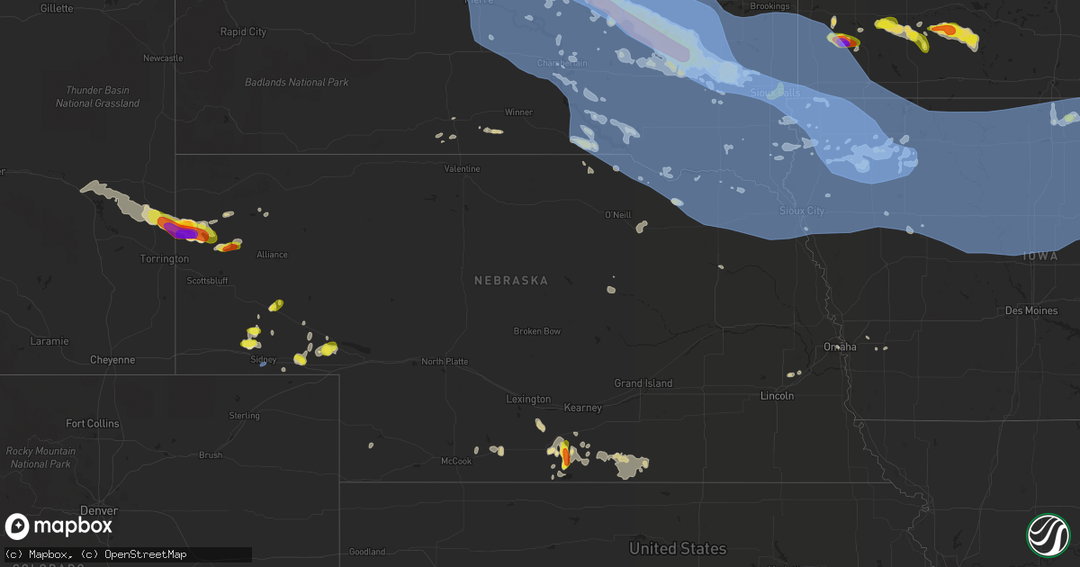
Hail Map in Nebraska on July 5, 2022
Get this storm
July 5 map
$229
one time, instant access
Download today. No call, no setup
Keep the $229
Bought the map and want the full workflow? Apply the entire $229 to a subscription within 7 days. None of it is wasted.
Every map, not just this one
This buys you this map. Subscription and you get every map we run, in the markets you choose from a few cities to whole states to nationwide. Plus real-time alerts the moment a storm fires.
Contact data
Name, contact info, occupancy, even credit band for addresses in the footprint. You go from where it hit to who to call.
Become the source they trust
Unlimited branding weather history reports on demand. You already have the documented answer ready for the property owner, and you are the one who showed up with it.
Property data and RoofTrace estimates
Pull up any address you have got, its value and the exact code rules for that jurisdiction, straight from One Click Code. Then RoofTrace estimates the squares, pitch, and roof value, priced the way you price.
Storm reports in Nebraska
Nebraska
| Date | Description |
|---|---|
| 07/05/20225:33 PM CDT | 61 knot gust at sidney airport. |
| 07/05/20225:33 PM CDT | 61 knot gust at sidney airport. |
| 07/05/20224:36 PM CDT | A local report indicates 59 MPH wind near 3 SSW NORFOLK |
| 07/05/20224:15 PM CDT | Trees down on highway 12 west of obert. |
| 07/05/20224:02 PM CDT | Small branches down and screen door blew off hinges. |
| 07/05/20224:00 PM CDT | A local report indicates 60 MPH wind near FORDYCE |
| 07/05/20223:50 PM CDT | Power line down. Time estimated based on radar data. |
| 07/05/20223:44 PM CDT | Tree and large limbs down on the golf course. |
| 07/05/20223:38 PM CDT | Tree down on a power line along highway 14. |
| 07/05/20223:10 PM CDT | A local report indicates 60 MPH wind near ONEILL |
| 07/05/20223:05 PM CDT | Tree limbs of 4 in diameter snapped. Winds estimated to be 50 mph. |
| 07/05/20222:39 PM CDT | Measured at flying m and d ranch mesonet site. |
| 07/05/20222:30 PM CDT | A local report indicates 65 MPH wind near BUTTE |
| 07/05/20222:26 PM CDT | A local report indicates 68 MPH wind near 7 WSW BUTTE |
| 07/05/20222:24 PM CDT | Several large tree limbs down. Time from radar. |
| 07/05/20221:48 PM CDT | A local report indicates 58 MPH wind near VALENTINE |
| 07/05/20223:12 AM CDT | At 812 PM CDT, a severe thunderstorm was located over Atlanta, or 9 miles southwest of Holdrege, moving northeast at 25 mph. HAZARD...60 mph wind gusts and quarter size hail. SOURCE...Radar indicated. IMPACT...Hail damage to vehicles is expected. Expect wind damage to roofs, siding, and trees. Locations impacted include... Holdrege. |
| 07/05/20223:02 AM CDT | At 801 PM CDT, a severe thunderstorm was located near Alma, or 20 miles south of Holdrege, moving northeast at 20 mph. HAZARD...60 mph wind gusts and half dollar size hail. SOURCE...Radar indicated. IMPACT...Hail damage to vehicles is expected. Expect wind damage to roofs, siding, and trees. This severe thunderstorm will be near... Huntley around 815 PM CDT.Other locations in the path of this severe thunderstorm includeRagan. |
| 07/05/20221:56 AM CDT | At 655 PM MDT, severe thunderstorms were located along a line extending from 12 miles south of Fort Robinson Campground to Lake Minatare Campground, moving east at 30 mph. HAZARD...60 mph wind gusts and quarter size hail. SOURCE...Radar indicated. This Severe Thunderstorm has had large, damaging hail reported in Sioux County Southwest of Agate, Nebraska earlier this evening. IMPACT...Hail damage to vehicles is expected. Expect wind damage to roofs, siding, and trees. Locations impacted include... Hemingford, Kilpatrick Lake, Box Butte Campground, Berea, Flahertys Corner, Box Butte Dam and Marsland. |
| 07/05/202212:56 AM CDT | At 555 PM MDT, a severe thunderstorm was located 10 miles southeast of Agate Bed National Monument, or 27 miles north of Scottsbluff, moving east at 35 mph. HAZARD...Tennis ball size hail and 70 mph wind gusts. SOURCE...Mesonet recorded 74mph wind gust in Goshen County at approximately 525pm. IMPACT...People and animals outdoors will be injured. Expect hail damage to roofs, siding, windows, and vehicles. Expect considerable tree damage. Wind damage is also likely to mobile homes, roofs, and outbuildings. This severe thunderstorm will remain over mainly rural areas of southern Sioux County. |
| 07/05/202212:49 AM CDT | At 549 PM MDT, a severe thunderstorm was located near Lewellen, or 12 miles southeast of Oshkosh, moving north at 35 mph. HAZARD...60 mph wind gusts and quarter size hail. SOURCE...Radar indicated. IMPACT...Hail damage to vehicles is expected. Expect wind damage to roofs, siding, and trees. Locations impacted include... Oshkosh, Lewellen, Ash Hollow State Historical Park, Eagle Gulch Campground, Ruthon, Belmar, Clear Creek State Wildlife Management Area, Intersection of Highway 27 and 9 Mile Road, Bluewater Battlefield State Historical Park, Otter Creek Campground and Windlass Hill.This includes Highway 92 between mile markers 115 and 127. |
| 07/05/202212:37 AM CDT | At 537 PM MDT, a severe thunderstorm was located 9 miles southwest of Agate Bed National Monument, or 21 miles northeast of Torrington, moving east at 30 mph. HAZARD...Golf ball size hail and 60 mph wind gusts. SOURCE...Radar indicated. IMPACT...People and animals outdoors will be injured. Expect hail damage to roofs, siding, windows, and vehicles. Expect wind damage to roofs, siding, and trees. This severe thunderstorm will remain over mainly rural areas of southern Sioux County. |
| 07/04/202211:37 PM CDT | At 437 PM MDT, a severe thunderstorm was located 9 miles northeast of The Intersection Of Highway 385 And 92, or 29 miles northwest of Oshkosh, moving northwest at 10 mph. HAZARD...60 mph wind gusts and quarter size hail. SOURCE...Radar indicated. IMPACT...Hail damage to vehicles is expected. Expect wind damage to roofs, siding, and trees. Locations impacted include... The Intersection Of Highway 385 And 92 and Broadwater. |
| 07/04/202211:30 PM CDT | At 429 PM MDT, a severe thunderstorm was located 7 miles south of Prairie Center, or 23 miles north of Torrington, moving northeast at 25 mph. HAZARD...Ping pong ball size hail and 60 mph wind gusts. SOURCE...Radar indicated. IMPACT...People and animals outdoors will be injured. Expect hail damage to roofs, siding, windows, and vehicles. Expect wind damage to roofs, siding, and trees. This severe thunderstorm will remain over mainly rural areas of west central Sioux and northeastern Goshen Counties. |
| 07/04/202210:46 PM CDT | At 346 PM CDT, severe thunderstorms were located along a line extending from 7 miles northwest of Chambers to 6 miles west of Ewing to near Orchard, moving southeast at 30 mph. HAZARD...60 mph wind gusts and quarter size hail. SOURCE...Radar indicated. IMPACT...Hail damage to vehicles is expected. Expect wind damage to roofs, siding, and trees. Locations impacted include... Ewing, Chambers, Page, Knievels Corner, Cumminsville, Four Corners, Buffalo Flats and Goose Lake State Wildlife Management Area.This includes the following highways... Highway 20 between mile markers 317 and 328. Highway 281 between mile markers 148 and 176. |
| 07/04/20229:44 PM CDT | At 242 PM CDT, severe thunderstorms were located along a line extending from 7 miles southwest of Kaylor to 8 miles northeast of Atkinson, moving southeast at 45 mph. HAZARD...60 mph wind gusts and quarter size hail. SOURCE...Radar indicated. IMPACT...Hail damage to vehicles is expected. Expect wind damage to roofs, siding, and trees. Locations impacted include... Yankton. |
| 07/04/20229:43 PM CDT | At 243 PM CDT, severe thunderstorms were located along a line extending from near Delmont to Wagner to near Spencer, moving southeast at 60 mph. HAZARD...60 mph wind gusts and penny size hail. SOURCE...Radar indicated. IMPACT...Expect damage to roofs, siding, and trees. Severe thunderstorms will be near... Dante around 250 PM CDT. Avon around 255 PM CDT.Other locations in the path of these severe thunderstorms includeTyndall, Springfield, Scotland, Tabor, Lewis And Clark StateRecreation Area, Utica, Yankton, Mayfield, Irene and Mission Hill. |
| 07/04/20229:15 PM CDT | At 215 PM CDT/115 PM MDT/, severe thunderstorms were located along a line extending from near Ainsworth to near Valentine National Wildlife Refuge to 9 miles south of Medicine Lake, moving southeast at 40 mph. HAZARD...60 mph wind gusts. SOURCE...Trained weather spotters. IMPACT...Expect damage to roofs, siding, and trees. Locations impacted include... Ainsworth, Bassett, Long Pine, Johnstown, Brownlee, Rose, Valentine National Wildlife Refuge, Elsmere, Wood Lake, Hofeld Lake, Raven, Twin Lakes State Wildlife Management Area, Willow Lake State Wildlife Management Area, Duff, Marsh Flat, Pine Glen State Wildlife Refuge, Antelope Peak, Indian Hill, Sevenmile Hill and Highway 97 crossing the North Loup River.This includes the following highways... Highway 183 between mile markers 153 and 204. Highway 20 between mile markers 221 and 263. Highway 97 between mile markers 74 and 114. Highway 83 between mile markers 159 and 193. |
| 07/04/20228:54 PM CDT | At 152 PM CDT, severe thunderstorms were located along a line extending from 6 miles southeast of Grass Ranch Colony to 13 miles west of Platte to near Dallas, moving southeast at 45 mph. HAZARD...70 mph wind gusts. SOURCE...Radar indicated. At 142 PM CDT, a 63 mph wind gust was reported 14 miles west of Platte. IMPACT...Expect considerable tree damage. Damage is likely to mobile homes, roofs, and outbuildings. Severe thunderstorms will be near... Platte around 200 PM CDT. Herrick and New Holland around 210 PM CDT. St. Charles around 215 PM CDT. Bonesteel and Geddes around 220 PM CDT. Armour around 230 PM CDT. Lake Andes around 235 PM CDT. Pickstown and Ravinia around 240 PM CDT. Wagner and Marty around 250 PM CDT.Other locations impacted by these severe thunderstorms includeFairfax and Yankton Sioux Tribal Nation. |
| 07/04/20228:40 PM CDT | Large tree limb down. |
| 07/04/20228:30 PM CDT | At 130 PM CDT, severe thunderstorms were located along a line extending from 8 miles northwest of Dallas to Millboro to 9 miles southeast of Littleburg, moving southeast at 50 mph. HAZARD...60 mph wind gusts. SOURCE...Radar indicated. IMPACT...Expect damage to roofs, siding, and trees. Locations impacted include... Ainsworth, Bassett, Springview, Long Pine, Newport, Johnstown, Norden, Wood Lake, Burton, Nets Peak, Bobcat State Wildlife Management Area, Meadville, North River Trail, Sparks, Keller Park State Recreation Area, Thomas Creek State Wildlife Management Area, Mariaville, Pine Glen State Wildlife Refuge, Antelope Peak and Mills.This includes the following highways... Highway 183 between mile markers 172 and 225. Highway 20 between mile markers 222 and 273. Highway 12 between mile markers 17 and 86. |
| 07/04/20228:16 PM CDT | Corrects previous tstm wnd dmg report from 4 w ragan. Social media report of very strong wind of unknown magnitude that took out a flag pole. Lawn furniture blown acros |
| 07/04/20228:09 PM CDT | Golf ball size at the largest in huntley. Power is out. Lots of tree limbs down. Probably 60 to 70 mph winds up. Lasted about 15 minutes. Fb report. |
| 07/04/20228:09 PM CDT | Power is out. Lots of tree limbs down. Probably 60 to 70 mph winds up. Lasted about 15 minutes. Fb report. |
| 07/04/20227:16 PM CDT | Social media report of very strong wind of unknown magnitude that took out a flag pole. Lawn furniture blown across the yard. Time estimated based on radar. |
| 07/04/20227:13 PM CDT | Report from mping: 3-inch tree limbs broken; power poles broken. Estimated 60 mph wind gust. |
| 07/04/20227:01 PM CDT | Trained spotter reports via social media and nwschat a measured 4.3 diameter hail stone. |
All States Impacted by Hail Map on July 5, 2022
Cities Impacted by Hail Map on July 5, 2022
- Seneca, SD
- Ekalaka, MT
- Peerless, MT
- Meadow, SD
- Fort Pierre, SD
- Union Center, SD
- Cohagen, MT
- Ambrose, ND
- Fortuna, ND
- Malta, MT
- Brusett, MT
- Jordan, MT
- Roy, MT
- Grass Range, MT
- Sand Springs, MT
- Winnett, MT
- Hilger, MT
- Lewistown, MT
- Ingomar, MT
- Reserve, MT
- Williston, ND
- Wolf Point, MT
- Plentywood, MT
- Flaxville, MT
- Homestead, MT
- Richland, MT
- Froid, MT
- Dagmar, MT
- Grenora, ND
- Medicine Lake, MT
- Bainville, MT
- Larslan, MT
- Brockton, MT
- Redstone, MT
- Scobey, MT
- Poplar, MT
- Hammond, MT
- Capitol, MT
- Prairie City, SD
- Bison, SD
- Faith, SD
- Lodgepole, SD
- Reva, SD
- Dupree, SD
- Glasgow, MT
- Hinsdale, MT
- Frazer, MT
- Nashua, MT
- Miller, SD
- Saint Lawrence, SD
- Chandler, MN
- Lake Wilson, MN
- Woodstock, MN
- Pukwana, SD
- Platte, SD
- Chamberlain, SD
- Fort Thompson, SD
- Lower Brule, SD
- New Hampton, IA
- Saint Francis, SD
- Slayton, MN
- Currie, MN
- Irene, SD
- Volin, SD
- Mission Hill, SD
- Nora Springs, IA
- Floyd, IA
- Rockford, IA
- Ionia, IA
- Charles City, IA
- Rudd, IA
- Waukon, IA
- Burke, SD
- Herrick, SD
- Fairfax, SD
- Saint Charles, SD
- Bonesteel, SD
- Lime Springs, IA
- Cresco, IA
- Powers Lake, ND
- Orient, SD
- Sheridan, WY
- Kimball, SD
- Comfrey, MN
- Revere, MN
- Westbrook, MN
- Bingham Lake, MN
- Lamberton, MN
- Walnut Grove, MN
- Storden, MN
- Sanborn, MN
- Jeffers, MN
- Mountain Lake, MN
- Canton, SD
- Inwood, IA
- Alcester, SD
- Hawarden, IA
- Hudson, SD
- Terry, MT
- Lindsay, MT
- Brockway, MT
- Iona, MN
- Atkinson, NE
- Spencer, SD
- Woonsocket, SD
- Fulton, SD
- Howard, SD
- Humboldt, SD
- Montrose, SD
- Wessington Springs, SD
- Mount Vernon, SD
- Wessington, SD
- Plankinton, SD
- Canova, SD
- Mitchell, SD
- Virgil, SD
- Alpena, SD
- Canistota, SD
- Artesian, SD
- Carthage, SD
- Fedora, SD
- Hartford, SD
- Letcher, SD
- Cavour, SD
- Alexandria, SD
- Huron, SD
- Wolsey, SD
- Salem, SD
- Highmore, SD
- Biddle, MT
- Carson, ND
- Ralph, SD
- Ludlow, SD
- Nashua, IA
- Plainfield, IA
- Hollandale, WI
- Harpers Ferry, IA
- Prairie Du Chien, WI
- Luana, IA
- Postville, IA
- Monona, IA
- Wolcottville, IN
- Apple River, IL
- Warren, IL
- Sioux Rapids, IA
- Webb, IA
- Marathon, IA
- Torrington, WY
- Agar, SD
- Gettysburg, SD
- Ree Heights, SD
- Timber Lake, SD
- Holabird, SD
- Onida, SD
- Ridgeview, SD
- Isabel, SD
- Harrold, SD
- Eagle Butte, SD
- Blanchardville, WI
- Sioux Center, IA
- Orange City, IA
- Beresford, SD
- Springfield, MN
- Boyes, MT
- Stitzer, WI
- Livingston, WI
- Woodman, WI
- Mount Hope, WI
- Boscobel, WI
- Fennimore, WI
- Pierre, SD
- Hospers, IA
- Sheldon, IA
- Baldwin, IA
- Naper, NE
- Zahl, ND
- Lansing, IA
- De Soto, WI
- Harmony, MN
- Buffalo, SD
- Deerfield, WI
- Gillette, WY
- Freeman, SD
- Bridgewater, SD
- Lagrange, IN
- Topeka, IN
- Waterville, IA
- Marcus, IA
- Sutherland, IA
- Larrabee, IA
- Peterson, IA
- Cherokee, IA
- Everly, IA
- Granville, IA
- Royal, IA
- Paullina, IA
- Hartley, IA
- Primghar, IA
- Meriden, IA
- Greenville, IA
- Cleghorn, IA
- Alton, IA
- Archer, IA
- Milwaukee, WI
- Greendale, WI
- Decorah, IA
- Lynch, NE
- Edgerton, WI
- Fort Atkinson, WI
- Watauga, SD
- Akaska, SD
- Lemmon, SD
- Hoven, SD
- McLaughlin, SD
- Morristown, SD
- Lebanon, SD
- Trail City, SD
- Selby, SD
- Glencross, SD
- Keldron, SD
- McIntosh, SD
- Tolstoy, SD
- Elma, IA
- Upton, WY
- Jefferson, WI
- Linn Grove, IA
- Waukesha, WI
- New Berlin, WI
- Winthrop, IA
- White Lake, SD
- Bremen, IN
- Plymouth, IN
- Nevada, OH
- Upper Sandusky, OH
- Osage, IA
- Little Cedar, IA
- Darfur, MN
- Saint James, MN
- Madelia, MN
- Lewisville, MN
- Sleepy Eye, MN
- Hanska, MN
- Vernon Center, MN
- Lake Crystal, MN
- Garden City, MN
- Amboy, MN
- Ireton, IA
- Rock Valley, IA
- Hemingford, NE
- Ruthton, MN
- Balaton, MN
- Garnavillo, IA
- Farmersburg, IA
- Riceville, IA
- Carson, IA
- Hartington, NE
- Wynot, NE
- Delmar, IA
- Lost Nation, IA
- Lewellen, NE
- Leesburg, IN
- North Webster, IN
- Pierceton, IN
- Reading, MI
- Quincy, MI
- Garden Prairie, IL
- Burlington, IL
- Elgin, IL
- Roscoe, IL
- South Beloit, IL
- Genoa, IL
- Woodstock, IL
- Walworth, WI
- Clinton, WI
- Caledonia, IL
- Beloit, WI
- Marengo, IL
- Sycamore, IL
- Kirkland, IL
- Harvard, IL
- Union, IL
- Sharon, WI
- Poplar Grove, IL
- Clare, IL
- Hampshire, IL
- Capron, IL
- Kingston, IL
- Belvidere, IL
- Carey, OH
- Minden, IA
- Neola, IA
- McClelland, IA
- Verdigre, NE
- Urbana, IN
- North Manchester, IN
- Fordyce, NE
- Crofton, NE
- Waverly, NE
- Greenwood, NE
- Goshen, IN
- Middlebury, IN
- Millersburg, IN
- Elkhart, IN
- Knoxville, TN
- Heiskell, TN
- Powell, TN
- Coldwater, MI
- Bronson, MI
- Naponee, NE
- Wilcox, NE
- Republican City, NE
- Bloomington, NE
- Manville, WY
- Saint Paris, OH
- Urbana, OH
- Galax, VA
- Woodlawn, VA
- Rocky Top, TN
- Andersonville, TN
- Clinton, TN
- Brookville, IN
- Sunman, IN
- Baltimore, OH
- Pataskala, OH
- Pickerington, OH
- Millersport, OH
- Carroll, OH
- Douglas, WY
- Harrison, NE
- Marsland, NE
- Churubusco, IN
- Laotto, IN
- Galion, OH
- Morganton, NC
- Connelly Springs, NC
- Lebanon, TN
- Gallatin, TN
- Hillsdale, MI
- Ixonia, WI
- Watertown, WI
- Oconomowoc, WI
- Sierra Blanca, TX
- Brodhead, WI
- Orfordville, WI
- Alma, NE
- Orleans, NE
- Pauline, SC
- Jonesville, SC
- Buffalo, SC
- Liberty, MS
- Gloster, MS
- Oneida, TN
- Dorchester, IA
- Winkelman, AZ
- Evansville, WI
- Mission, SD
- Hazel Green, WI
- Cuba City, WI
- Vinton, VA
- Goodview, VA
- Glendo, WY
- Jay Em, WY
- Fort Wayne, IN
- Midwest, WY
- Hull, IA
- Montfort, WI
- Waverly, IA
- Janesville, IA
- Alliance, NE
- Lake View, IA
- Wall Lake, IA
- Crystal Lake, IL
- Camden, MI
- Milford, OH
- Georgetown, OH
- Bethel, OH
- Batavia, OH
- Camp Dennison, OH
- Cincinnati, OH
- Terrace Park, OH
- New Richmond, OH
- Loveland, OH
- Miamiville, OH
- Amelia, OH
- Hamersville, OH
- Felicity, OH
- Blountville, TN
- Brooksville, KY
- Montross, VA
- Decatur, AL
- Manilla, IN
- Rushville, IN
- Homer, IN
- Arlington, IN
- Caledonia, OH
- Lake Andes, SD
- Broadwater, NE
- Winnetoon, NE
- Creighton, NE
- Rock Rapids, IA
- Steen, MN
- Winner, SD
- Sac City, IA
- Bloomfield, NE
- McGregor, IA
- Walker, IA
- Coggon, IA
- Platteville, WI
- Belmont, WI
- Darlington, WI
- Geneva, IN
- Page, NE
- Ewing, NE
- Orchard, NE
- Debord, KY
- Inez, KY
- Warren, IN
- Norfolk, NE
- Stanton, NE
- Hartford City, IN
- Lancaster, OH
- Bremen, OH
- Lancaster, WI
- Frenchburg, KY
- Ridgeway, IA
- Martinsville, VA
- West Union, IA
- Ossian, IA
- Castalia, IA
- Spillville, IA
- Waucoma, IA
- Lawler, IA
- Fort Atkinson, IA
- Calmar, IA
- Protivin, IA
- Montpelier, IN
- Ney, OH
- Sherwood, OH
- Napoleon, OH
- Defiance, OH
- Reliance, TN
- Kimper, KY
- Canada, KY
- Fort Stockton, TX
- Chappell, NE
- Wise, VA
- Browntown, WI
- Independence, IA
- Lovington, NM
- Elizabeth, IL
- Stockton, IL
- Glenrock, WY
- Big Springs, NE
- Potter, NE
- Gurley, NE
- Sidney, NE
- Monticello, WI
- Argyle, WI
- Dalton, NE
- Mount Gilead, OH
- Benton Harbor, MI
- Hartford, MI
- Cloverdale, OH
- Fort Jennings, OH
- Harpster, OH
- Alpine, TX
- Valentine, TX
- Moravian Falls, NC
- Newland, NC
- Quincy, OH
- Sidney, OH
- Piqua, OH
- Fletcher, OH
- De Graff, OH
- Rosewood, OH
- Conover, OH
- New Glarus, WI
- Gratiot, WI
- Mount Horeb, WI
- Monroe, WI
- South Wayne, WI
- New Riegel, OH
- Alvada, OH
- Swanton, OH
- Lake Geneva, WI
- Wolcott, IN
- Reynolds, IN
- Williamsburg, KY
- Jellico, TN
- Pacolet, SC
- Page, AZ
- Emery, SD
- Van Wert, OH
- Hoagland, IN
- Monroeville, IN
- Convoy, OH
- New Haven, IN
- Rockford, OH
- Wren, OH
- Decatur, IN
- Ohio City, OH
- Willshire, OH
- Oshkosh, NE
- Ericson, NE
- Albion, IN
- Huntertown, IN
- Rewey, WI
- Mansfield, OH
- Omaha, NE
- Marion, NC
- Dunkirk, IN
- Boonville, IN
- Chandler, IN
- Osseo, MI
- Albany, WI
- Janesville, WI
- La Follette, TN
- Wellford, SC
- Startex, SC
- Spartanburg, SC
- Inman, SC
- Moore, SC
- Lyman, SC
- Woodruff, SC
- Duncan, SC
- Helenville, WI
- Fleming, CO
- Shawnee, WY
- Carthage, IN
- Benton, WI
- Shullsburg, WI
- Dubuque, IA
- East Dubuque, IL
- Scales Mound, IL
- Galena, IL
- Celina, OH
- Tiro, OH
- New Washington, OH
- Forest, OH
- Linden, WI
- Mineral Point, WI
- Westerville, OH
- Deep Gap, NC
- Ferguson, NC
- Boone, NC
- Granville, OH
- Alexandria, OH
- Concho, AZ
- Iaeger, WV
- Sergeant Bluff, IA
- Salix, IA
- Shipshewana, IN
- Leipsic, OH
- Ottawa, OH
- Miller City, OH
- Continental, OH
- Muncie, IN
- Granville, TN
- Somerset, KY
- Bloomville, OH
- Galena, OH
- Louisa, KY
- Ulysses, KY
- New Albany, OH
- Johnstown, OH
- Onarga, IL
- Ridgeville, IN
- Farmland, IN
- Manchester, KY
- Grandfalls, TX
- Hildreth, NE
- Winslow, AZ
- Sparta, NC
- Laurel Springs, NC
- Clearmont, WY
- Greer, SC
- Chuckey, TN
- Limestone, TN
- Afton, TN
- Ligonier, IN
- Wawaka, IN
- Morehead, KY
- Holdrege, NE
- Atlanta, NE
- Mason City, IA
- Northwood, IA
- Joice, IA
- Grafton, IA
- Kensett, IA
- Plymouth, IA
- Hanlontown, IA
- Manly, IA
- Burlington, WI
- Bucyrus, OH
- Thawville, IL
- Hobbs, NM
- Fairbank, IA
- Denver, IA
- Dunkerton, IA
- Hazleton, IA
- Readlyn, IA
- Jesup, IA
- White Pigeon, MI
- Bristol, IN
- Ashland, NE
- Stearns, KY
- Caryville, TN
- Jacksboro, TN
- Rogersville, TN
- Surgoinsville, TN
- Riverton, NE
- Bladen, NE
- Franklin, NE
- Upland, NE
- Campbell, NE
- Blue Hill, NE
- Inavale, NE
- Red Cloud, NE
- Guide Rock, NE
- Grove City, OH
- Purlear, NC
- Axtell, NE
- Maurice, IA
- Geddes, SD
- Armour, SD
- Gann Valley, SD
- Loomis, NE
- Bertrand, NE
- Smithfield, NE
- Springfield, SD
- Avon, SD
- Millport, AL
- Knightstown, IN
- Imperial, TX
- Axton, VA
- Yadkinville, NC
- New Leipzig, ND
- Blue River, WI
- Muscoda, WI
- Crawford, NE
- Oxford Junction, IA
- Sullivan, WI
- Johnson Creek, WI
- West Liberty, KY
- Salyersville, KY
- Rockford, IL
- Spencer, IA
- Galva, IA
- Schaller, IA
- Marathon, TX
- Cambridge, NE
- Bartley, NE
- Holbrook, NE
- Alzada, MT
- Commiskey, IN
- North Vernon, IN
- Presho, SD
- Oacoma, SD
- Larchwood, IA
- Lester, IA
- Advance, NC
- Andrews, IN
- Lagro, IN
- Adel, GA
- Sparks, GA
- Howe, IN
- Mason, OH
- Gaffney, SC
- Indianola, NE
- Gillett Grove, IA
- Richland Center, WI
- Vandalia, MI
- Jones, MI
- Marion, OH
- Lisco, NE
- Potosi, WI
- Mishawaka, IN
- Wakarusa, IN
- Roaring River, NC
- Clay, WV
- Prestonsburg, KY
- Spencer, NE
- Danville, AL
- Vinemont, AL
- Columbia City, IN
- Tulare, SD
- Hitchcock, SD
- Marion, SD
- Ryan, IA
- Lusk, WY
- Niobrara, NE
- Bridgeport, NE
- Crestline, OH
- Imperial, NE
- Benkelman, NE
- Brookston, IN
- Traphill, NC
- Hays, NC
- Stoughton, WI
- Cambridge, WI
- Lodgepole, NE
- Hicksville, OH
- Mukwonago, WI
- Constantine, MI
- Sturgis, MI
- Three Rivers, MI
- Morral, OH
- Central City, KY
- Bremen, KY
- Ashland, OH
- Seminole, TX
- Kingsley, IA
- Hinton, IA
- Avilla, IN
- Kendallville, IN
- Larwill, IN
- Kimmell, IN
- Rome City, IN
- Sitka, KY
- Flatgap, KY
- Staffordsville, KY
- Augusta, KY
- Raccoon, KY
- Pikeville, KY
- Monmouth, IA
- Wyoming, IA
- Lawndale, NC
- Gate City, VA
- Fries, VA
- Warfield, KY
- Kermit, WV
- Westby, MT
- Hettinger, ND
- Alamo, ND
- Crosby, ND
- Church Hill, TN
- Colfax, NC
- Kernersville, NC
- High Point, NC
- Greensboro, NC
- Whitehorse, SD
- Java, SD
- Onaka, SD
- Faulkton, SD
- Glenham, SD
- Meservey, IA
- Olin, IA
- Magnolia, MN
- Dayton, IA
- Allison, IA
- Rolfe, IA
- Bristow, NE
- Lowden, IA
- Leota, MN
- Titonka, IA
- Milford, IA
- Carpenter, SD
- Alexander, IA
- Ogden, IA
- North Sioux City, SD
- Ames, IA
- Edgerton, MN
- Graettinger, IA
- Lake City, IA
- Coleridge, NE
- Zearing, IA
- Clemons, IA
- Rockham, SD
- Jefferson, IA
- Rembrandt, IA
- Wheatland, IA
- Jolley, IA
- Armstrong, IA
- Laurel, NE
- Goldfield, IA
- Gayville, SD
- Wagner, SD
- Parkersburg, IA
- McCallsburg, IA
- Duncombe, IA
- Hampton, IA
- Wallingford, IA
- Willow Lake, SD
- Woolstock, IA
- Rutland, SD
- Dimock, SD
- Clarion, IA
- Magnet, NE
- Rockwell, IA
- Welton, IA
- Arlington, SD
- George, IA
- Burbank, SD
- Garner, IA
- Quasqueton, IA
- Fulda, MN
- Oran, IA
- Renner, SD
- Dumont, IA
- Whittemore, IA
- Bode, IA
- Alta Vista, IA
- Stephan, SD
- Ocheyedan, IA
- Stanley, IA
- Wesley, IA
- Williams, IA
- Rushmore, MN
- Bancroft, IA
- Stanwood, IA
- Odebolt, IA
- Ethan, SD
- Aredale, IA
- Estherville, IA
- Swea City, IA
- Rutland, IA
- Dike, IA
- Kennebec, SD
- Nunda, SD
- Vinton, IA
- Holland, IA
- Correctionville, IA
- Popejoy, IA
- Climbing Hill, IA
- Utica, SD
- Solon, IA
- Lohrville, IA
- Moville, IA
- Farnhamville, IA
- Reading, MN
- Madison, SD
- Chapin, IA
- Kenneth, MN
- Westgate, IA
- Otho, IA
- Jefferson, SD
- Iowa Falls, IA
- Mount Vernon, IA
- Aurora, SD
- Boxholm, IA
- Lisbon, IA
- Hawkeye, IA
- Buffalo Center, IA
- Robins, IA
- Stacyville, IA
- Brunsville, IA
- Stout, IA
- Gilmore City, IA
- Eagle Grove, IA
- Hardy, IA
- Calamus, IA
- Hardwick, MN
- Laurens, IA
- Brookings, SD
- Burnside, IA
- Little Rock, IA
- Masonville, IA
- Winnebago, NE
- Boone, IA
- Dewar, IA
- Fonda, IA
- Hubbard, IA
- Maynard, IA
- Ramona, SD
- Thompson, IA
- Oldham, SD
- Knierim, IA
- Morrison, IA
- Mount Auburn, IA
- Dana, IA
- Fenton, IA
- Aurelia, IA
- Delmont, SD
- Varina, IA
- Goodell, IA
- Ashton, IA
- Thornton, IA
- Bradford, IA
- Galt, IA
- Mclean, NE
- Blairsburg, IA
- Waterbury, NE
- Bristow, IA
- Lakefield, MN
- Frederika, IA
- Hurley, SD
- Moorland, IA
- Arthur, IA
- Dakota City, NE
- Kanawha, IA
- Lyons, SD
- Swisher, IA
- Nevada, IA
- Whitten, IA
- Eldora, IA
- Tyndall, SD
- Pocahontas, IA
- Saint Ansgar, IA
- Tripoli, IA
- Pickstown, SD
- Oto, IA
- Gilbert, IA
- Egan, SD
- Melvin, IA
- Hamill, SD
- Marble Rock, IA
- Randolph, NE
- Rowley, IA
- Aplington, IA
- Vermillion, SD
- Oelwein, IA
- Lehigh, IA
- Spirit Lake, IA
- Sioux Falls, SD
- West Bend, IA
- Monticello, IA
- Wellsburg, IA
- Dows, IA
- Center Junction, IA
- Fort Dodge, IA
- Hiawatha, IA
- Pierson, IA
- Clarksville, IA
- Albert City, IA
- Conrad, IA
- Arnolds Park, IA
- Ringsted, IA
- Quimby, IA
- New Providence, IA
- Carpenter, IA
- Ellsworth, MN
- Emmetsburg, IA
- McCausland, IA
- Jewell, IA
- Roland, IA
- Sloan, IA
- Story City, IA
- Gilbertville, IA
- Morley, IA
- Bronson, IA
- Fertile, IA
- Nemaha, IA
- Lu Verne, IA
- Raymond, IA
- Dante, SD
- De Smet, SD
- Bennett, IA
- Brandon, SD
- Coulter, IA
- Churdan, IA
- Danbury, IA
- Jackson, NE
- Lennox, SD
- Maskell, NE
- Stickney, SD
- Center Point, IA
- Lake Mills, IA
- Lyle, MN
- Low Moor, IA
- Mallard, IA
- Belmond, IA
- Matlock, IA
- Saint Anthony, IA
- Klemme, IA
- Sumner, IA
- Reinbeck, IA
- Geneva, IA
- Shellsburg, IA
- Blunt, SD
- Cushing, IA
- Dundee, IA
- Latimer, IA
- Merrill, IA
- Leland, IA
- Woden, IA
- Wausa, NE
- Akron, IA
- Webster City, IA
- Pipestone, MN
- Livermore, IA
- Elkton, SD
- Butte, NE
- Draper, SD
- Redfield, SD
- Tabor, SD
- Dixon, NE
- Early, IA
- McIntire, IA
- Oyens, IA
- Lawton, IA
- Thor, IA
- Alburnett, IA
- Plover, IA
- Newcastle, NE
- Kesley, IA
- Jasper, MN
- Fostoria, IA
- Burt, IA
- Anamosa, IA
- Anthon, IA
- Sanborn, IA
- Shell Rock, IA
- Scarville, IA
- Ellsworth, IA
- Dickens, IA
- Scotland, SD
- Brandon, IA
- Washta, IA
- Reliance, SD
- Hudson, IA
- Somers, IA
- Battle Creek, IA
- Clare, IA
- Clarence, IA
- Ackley, IA
- Cedar Falls, IA
- Ayrshire, IA
- Worthington, MN
- Wayne, NE
- Newell, IA
- Crystal Lake, IA
- Holland, MN
- Wilmont, MN
- Dakota City, IA
- Chatsworth, IA
- Menno, SD
- Barnum, IA
- Harcourt, IA
- Elk Point, SD
- Central City, IA
- Callender, IA
- Viborg, SD
- Lesterville, SD
- Beaver Creek, MN
- Carroll, NE
- Yankton, SD
- Colwell, IA
- Truesdale, IA
- Okoboji, IA
- Springville, IA
- Wentworth, SD
- La Porte City, IA
- Colton, SD
- Lakota, IA
- Doon, IA
- Urbana, IA
- Pomeroy, IA
- Luverne, MN
- Adrian, MN
- Bigelow, MN
- Clinton, IA
- Cedar Rapids, IA
- Union, IA
- Rockwell City, IA
- Remsen, IA
- Ida Grove, IA
- Calumet, IA
- Hubbard, NE
- Monroe, SD
- Bryant, IA
- Paton, IA
- Austinville, IA
- Lismore, MN
- Sioux City, IA
- Tea, SD
- Harrison, SD
- Worthing, SD
- Parkston, SD
- De Witt, IA
- Curlew, IA
- Osmond, NE
- Fredericksburg, IA
- Manchester, IA
- Davis, SD
- Long Grove, IA
- Tripp, SD
- Boyden, IA
- Garden City, IA
- Gowrie, IA
- Corsica, SD
- Swaledale, IA
- Holstein, IA
- Randall, IA
- Badger, IA
- Grundy Center, IA
- Alvord, IA
- Harrisburg, SD
- Belden, NE
- Gregory, SD
- Sibley, IA
- Radcliffe, IA
- Fairfax, IA
- Le Mars, IA
- Ruthven, IA
- Steamboat Rock, IA
- Martelle, IA
- Emerson, NE
- Center, NE
- Algona, IA
- Charlotte, IA
- Plainview, NE
- Volga, SD
- Flandreau, SD
- Garretson, SD
- Storm Lake, IA
- Yale, SD
- Palo, IA
- New Hartford, IA
- Grand Mound, IA
- Rowan, IA
- Hills, MN
- Arlington, IA
- Chester, SD
- Trent, SD
- Cylinder, IA
- Brewster, MN
- Crooks, SD
- Goose Lake, IA
- Dougherty, IA
- Aurora, IA
- Allen, NE
- Parker, SD
- Lake Park, IA
- Marion, IA
- Greene, IA
- Kaylor, SD
- Round Lake, MN
- Clear Lake, IA
- Rock Falls, IA
- Lake Preston, SD
- Ventura, IA
- Homer, NE
- Wakonda, SD
- Evansdale, IA
- Corwith, IA
- Kanaranzi, MN
- Orchard, IA
- Sheffield, IA
- Colman, SD
- Atkins, IA
- Vivian, SD
- South Sioux City, NE
- Saint Helena, NE
- Alta, IA
- Winfred, SD
- Bradgate, IA
- New Holland, SD
- Forest City, IA
- Ely, IA
- Westfield, IA
- Lamont, IA
- Humboldt, IA
- Chancellor, SD
- Wakefield, NE
- Stanhope, IA
- Camanche, IA
- Toddville, IA
- Havelock, IA
- Britt, IA
- Maquoketa, IA
- Valley Springs, SD
- Waterloo, IA
- Hornick, IA
- Tipton, IA
- Ponca, NE
- Iroquois, SD
- Harris, IA
- Stratford, IA
- Fairview, SD
- Baltic, SD
- Terril, IA
- Ottosen, IA
- Pilot Mound, IA
- Concord, NE
- Olivet, SD
- Vincent, IA
- Centerville, SD
- Randalia, IA
- Fayette, IA
- Lytton, IA
- Palmer, IA
- Dell Rapids, SD
- Kamrar, IA
- Auburn, IA
- Lone Rock, IA
- Renwick, IA
- Alden, IA
- Manson, IA
- Mechanicsville, IA
- Butterfield, MN
- Fort Peck, MT
- Forsyth, MT
- Powderville, MT
- Volborg, MT
- Ismay, MT
- Glendive, MT
- Circle, MT
- Bowie, MD
- Rozet, WY
- Scott, OH
- Payne, OH
- Grabill, IN
- Woodburn, IN


