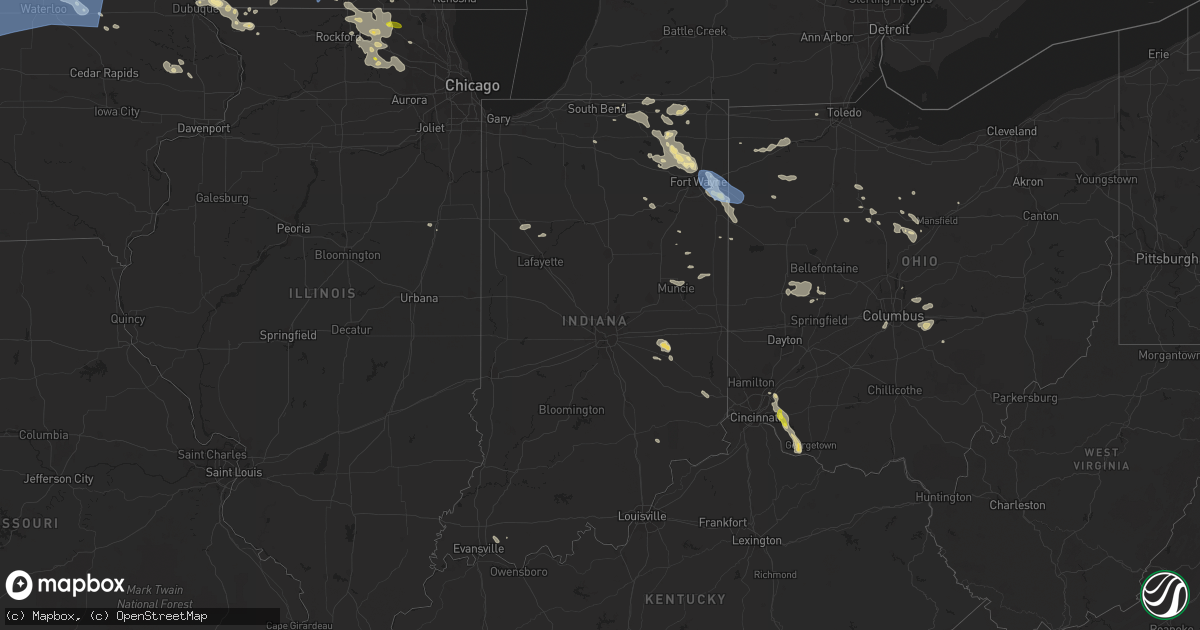
Hail Map in Indiana on July 5, 2022
Get this storm
July 5 map
$229
one time, instant access
Download today. No call, no setup
Keep the $229
Bought the map and want the full workflow? Apply the entire $229 to a subscription within 7 days. None of it is wasted.
Every map, not just this one
This buys you this map. Subscription and you get every map we run, in the markets you choose from a few cities to whole states to nationwide. Plus real-time alerts the moment a storm fires.
Contact data
Name, contact info, occupancy, even credit band for addresses in the footprint. You go from where it hit to who to call.
Become the source they trust
Unlimited branding weather history reports on demand. You already have the documented answer ready for the property owner, and you are the one who showed up with it.
Property data and RoofTrace estimates
Pull up any address you have got, its value and the exact code rules for that jurisdiction, straight from One Click Code. Then RoofTrace estimates the squares, pitch, and roof value, priced the way you price.
Storm reports in Indiana
Indiana
| Date | Description |
|---|---|
| 07/05/20224:52 PM CDT | Tree limbs on power lines in chandler and near newburgh. |
| 07/05/20222:45 PM CDT | 12-15 inch trees downed on the north side of rushville. May have been weakened by storms last week. |
| 07/05/20221:25 PM CDT | Several large trees snapped at trunks |
| 07/05/20228:50 AM CDT | Powerlines down in water along us 24 between cr 1100 n and sr 114. |
| 07/05/20228:05 AM CDT | 2 healthy 1 foot in diameter pine trees snapped. Time estimated from radar. |
| 07/05/20228:00 AM CDT | Trees branches of 1-3 inches in diameter snapped along us-30 near crazy joes fireworks. Time estimated from radar. |
| 07/05/20224:38 AM CDT | At 938 PM EDT, a severe thunderstorm was located 7 miles west of Ohio City, moving south at 30 mph. HAZARD...60 mph wind gusts and nickel size hail. SOURCE...Radar indicated. IMPACT...Expect damage to trees and power lines. Locations impacted include... Celina, Coldwater, St. Henry, Fort Recovery, Rockford, Wabash, Mendon, Chickasaw, Montezuma, Chattanooga, Tama, Neptune and Carthagena. |
| 07/05/20224:28 AM CDT | At 927 PM EDT, a severe thunderstorm was located near Convoy, or 8 miles west of Van Wert, moving southeast at 45 mph. HAZARD...70 mph wind gusts. SOURCE...Radar indicated. IMPACT...Expect considerable tree damage. Damage is likely to mobile homes, roofs, and outbuildings. Locations impacted include... Van Wert, Convoy, Ohio City, Middlebury, Willshire, Wren, Venedocia, Elgin, Monticello, Glenmore, Dull, Abanaka, Jonestown, Rivare and Schumm. |
| 07/05/20221:59 AM CDT | At 659 PM EDT, a severe thunderstorm was located near Millersburg, or 7 miles east of Goshen, moving east at 20 mph. HAZARD...60 mph wind gusts and penny size hail. SOURCE...Radar indicated. IMPACT...Expect damage to roofs, siding, and trees. Locations impacted include... Goshen, Ligonier, Lagrange, Middlebury, Topeka, Millersburg, Honeyville, Eddy, Oliver Lake, Emma and Cosperville. |
| 07/04/202211:45 PM CDT | At 445 PM CDT, a severe thunderstorm was located over Chandler, moving southeast at 10 mph. HAZARD...Ping pong ball size hail and 60 mph wind gusts. SOURCE...Radar indicated. IMPACT...People and animals outdoors will be injured. Expect hail damage to roofs, siding, windows, and vehicles. Expect wind damage to roofs, siding, and trees. This severe thunderstorm will be near... Boonville around 505 PM CDT. |
| 07/04/202211:09 PM CDT | Corrects previous tstm wnd dmg report from 2 nw osceola. Several small tree branches and one larger limb of estimated 12 inches in diameter down on buckeye road. Time e |
| 07/04/202211:09 PM CDT | Several small tree branches and one larger limb of estimated 12 inches in diameter down on buckeye road. Time estimated from radar. |
| 07/04/202211:03 PM CDT | At 403 AM EDT, a severe thunderstorm was located near Columbia City, moving southeast at 40 mph. HAZARD...60 mph wind gusts. SOURCE...Radar indicated. IMPACT...Expect damage to roofs, siding, and trees. Locations impacted include... Fort Wayne, Columbia City, Nine Mile, Collins, Arcola, Dunfee, Rolling Hills, Coesse and Lake Everett.This includes the following highways... Interstate 469 near mile marker 2. Interstate 69 in Indiana between mile markers 299 and 313. |
| 07/04/20228:03 PM CDT | Tornado siren pole snapped and down onto a car. Time estimated from radar. |
| 07/04/20228:03 PM CDT | Roof blown off of the old premier glass building. Time estimated from radar. |
| 07/04/20227:59 PM CDT | Report from mping: 3-inch tree limbs broken; power poles broken. |
| 07/04/20227:59 PM CDT | Report from mping: 1-inch tree limbs broken; shingles blown off. |
| 07/04/20227:59 PM CDT | Report from mping: 1-inch tree limbs broken; shingles blown off. |
| 07/04/20227:56 PM CDT | Report from mping: 1-inch tree limbs broken; shingles blown off. |
| 07/04/20227:54 PM CDT | Report from mping: trees uprooted or snapped; roof blown off. |
| 07/04/20227:51 PM CDT | Report from mping: 1-inch tree limbs broken; shingles blown off. |
| 07/04/20227:50 PM CDT | Tree limbs down and estimated wind gusts to 60 mph. |
| 07/04/20227:45 PM CDT | Large tree down across monroeville rd... East of us 27. Time estimated from radar. |
| 07/04/20227:45 PM CDT | Two foot diameter tree uprooted... Blocking sagimore ct. |
| 07/04/20227:45 PM CDT | Several large trees down... Up to eight inches in diameter near besocson church. Time estimated from radar. |
| 07/04/20227:45 PM CDT | Large partially rotten tree limb broken in new haven. |
| 07/04/20227:42 PM CDT | Trees downed at us 30 and doyle rds. |
| 07/04/20227:40 PM CDT | Fence blown down... Flag pole bent to the ground. |
| 07/04/20227:40 PM CDT | Report from mping: 3-inch tree limbs broken; power poles broken. |
| 07/04/20227:37 PM CDT | Trained spotter south side fort wayne... Estimated 70 mph gusts... Wall cloud forming north. |
| 07/04/20227:35 PM CDT | Large tree snapped and down on lake avenue. Time estimated from radar. |
| 07/04/20227:35 PM CDT | Trees down on south wayne ave. Time estimated from radar. |
| 07/04/20227:33 PM CDT | Large tree uprooted onto two cars on wayne street... In between union street and rockhill street. Time estimated from radar. |
| 07/04/20227:33 PM CDT | Wind gusts of 55 to 60 mph. |
| 07/04/20227:31 PM CDT | Report from mping: trees uprooted or snapped; roof blown off. |
| 07/04/20227:30 PM CDT | Multiple trees down with the largest eight to ten inches in diameter just south of smith field. Time estimated from radar. |
All States Impacted by Hail Map on July 5, 2022
Cities Impacted by Hail Map on July 5, 2022
- Seneca, SD
- Ekalaka, MT
- Peerless, MT
- Meadow, SD
- Fort Pierre, SD
- Union Center, SD
- Cohagen, MT
- Ambrose, ND
- Fortuna, ND
- Malta, MT
- Brusett, MT
- Jordan, MT
- Roy, MT
- Grass Range, MT
- Sand Springs, MT
- Winnett, MT
- Hilger, MT
- Lewistown, MT
- Ingomar, MT
- Reserve, MT
- Williston, ND
- Wolf Point, MT
- Plentywood, MT
- Flaxville, MT
- Homestead, MT
- Richland, MT
- Froid, MT
- Dagmar, MT
- Grenora, ND
- Medicine Lake, MT
- Bainville, MT
- Larslan, MT
- Brockton, MT
- Redstone, MT
- Scobey, MT
- Poplar, MT
- Hammond, MT
- Capitol, MT
- Prairie City, SD
- Bison, SD
- Faith, SD
- Lodgepole, SD
- Reva, SD
- Dupree, SD
- Glasgow, MT
- Hinsdale, MT
- Frazer, MT
- Nashua, MT
- Miller, SD
- Saint Lawrence, SD
- Chandler, MN
- Lake Wilson, MN
- Woodstock, MN
- Pukwana, SD
- Platte, SD
- Chamberlain, SD
- Fort Thompson, SD
- Lower Brule, SD
- New Hampton, IA
- Saint Francis, SD
- Slayton, MN
- Currie, MN
- Irene, SD
- Volin, SD
- Mission Hill, SD
- Nora Springs, IA
- Floyd, IA
- Rockford, IA
- Ionia, IA
- Charles City, IA
- Rudd, IA
- Waukon, IA
- Burke, SD
- Herrick, SD
- Fairfax, SD
- Saint Charles, SD
- Bonesteel, SD
- Lime Springs, IA
- Cresco, IA
- Powers Lake, ND
- Orient, SD
- Sheridan, WY
- Kimball, SD
- Comfrey, MN
- Revere, MN
- Westbrook, MN
- Bingham Lake, MN
- Lamberton, MN
- Walnut Grove, MN
- Storden, MN
- Sanborn, MN
- Jeffers, MN
- Mountain Lake, MN
- Canton, SD
- Inwood, IA
- Alcester, SD
- Hawarden, IA
- Hudson, SD
- Terry, MT
- Lindsay, MT
- Brockway, MT
- Iona, MN
- Atkinson, NE
- Spencer, SD
- Woonsocket, SD
- Fulton, SD
- Howard, SD
- Humboldt, SD
- Montrose, SD
- Wessington Springs, SD
- Mount Vernon, SD
- Wessington, SD
- Plankinton, SD
- Canova, SD
- Mitchell, SD
- Virgil, SD
- Alpena, SD
- Canistota, SD
- Artesian, SD
- Carthage, SD
- Fedora, SD
- Hartford, SD
- Letcher, SD
- Cavour, SD
- Alexandria, SD
- Huron, SD
- Wolsey, SD
- Salem, SD
- Highmore, SD
- Biddle, MT
- Carson, ND
- Ralph, SD
- Ludlow, SD
- Nashua, IA
- Plainfield, IA
- Hollandale, WI
- Harpers Ferry, IA
- Prairie Du Chien, WI
- Luana, IA
- Postville, IA
- Monona, IA
- Wolcottville, IN
- Apple River, IL
- Warren, IL
- Sioux Rapids, IA
- Webb, IA
- Marathon, IA
- Torrington, WY
- Agar, SD
- Gettysburg, SD
- Ree Heights, SD
- Timber Lake, SD
- Holabird, SD
- Onida, SD
- Ridgeview, SD
- Isabel, SD
- Harrold, SD
- Eagle Butte, SD
- Blanchardville, WI
- Sioux Center, IA
- Orange City, IA
- Beresford, SD
- Springfield, MN
- Boyes, MT
- Stitzer, WI
- Livingston, WI
- Woodman, WI
- Mount Hope, WI
- Boscobel, WI
- Fennimore, WI
- Pierre, SD
- Hospers, IA
- Sheldon, IA
- Baldwin, IA
- Naper, NE
- Zahl, ND
- Lansing, IA
- De Soto, WI
- Harmony, MN
- Buffalo, SD
- Deerfield, WI
- Gillette, WY
- Freeman, SD
- Bridgewater, SD
- Lagrange, IN
- Topeka, IN
- Waterville, IA
- Marcus, IA
- Sutherland, IA
- Larrabee, IA
- Peterson, IA
- Cherokee, IA
- Everly, IA
- Granville, IA
- Royal, IA
- Paullina, IA
- Hartley, IA
- Primghar, IA
- Meriden, IA
- Greenville, IA
- Cleghorn, IA
- Alton, IA
- Archer, IA
- Milwaukee, WI
- Greendale, WI
- Decorah, IA
- Lynch, NE
- Edgerton, WI
- Fort Atkinson, WI
- Watauga, SD
- Akaska, SD
- Lemmon, SD
- Hoven, SD
- McLaughlin, SD
- Morristown, SD
- Lebanon, SD
- Trail City, SD
- Selby, SD
- Glencross, SD
- Keldron, SD
- McIntosh, SD
- Tolstoy, SD
- Elma, IA
- Upton, WY
- Jefferson, WI
- Linn Grove, IA
- Waukesha, WI
- New Berlin, WI
- Winthrop, IA
- White Lake, SD
- Bremen, IN
- Plymouth, IN
- Nevada, OH
- Upper Sandusky, OH
- Osage, IA
- Little Cedar, IA
- Darfur, MN
- Saint James, MN
- Madelia, MN
- Lewisville, MN
- Sleepy Eye, MN
- Hanska, MN
- Vernon Center, MN
- Lake Crystal, MN
- Garden City, MN
- Amboy, MN
- Ireton, IA
- Rock Valley, IA
- Hemingford, NE
- Ruthton, MN
- Balaton, MN
- Garnavillo, IA
- Farmersburg, IA
- Riceville, IA
- Carson, IA
- Hartington, NE
- Wynot, NE
- Delmar, IA
- Lost Nation, IA
- Lewellen, NE
- Leesburg, IN
- North Webster, IN
- Pierceton, IN
- Reading, MI
- Quincy, MI
- Garden Prairie, IL
- Burlington, IL
- Elgin, IL
- Roscoe, IL
- South Beloit, IL
- Genoa, IL
- Woodstock, IL
- Walworth, WI
- Clinton, WI
- Caledonia, IL
- Beloit, WI
- Marengo, IL
- Sycamore, IL
- Kirkland, IL
- Harvard, IL
- Union, IL
- Sharon, WI
- Poplar Grove, IL
- Clare, IL
- Hampshire, IL
- Capron, IL
- Kingston, IL
- Belvidere, IL
- Carey, OH
- Minden, IA
- Neola, IA
- McClelland, IA
- Verdigre, NE
- Urbana, IN
- North Manchester, IN
- Fordyce, NE
- Crofton, NE
- Waverly, NE
- Greenwood, NE
- Goshen, IN
- Middlebury, IN
- Millersburg, IN
- Elkhart, IN
- Knoxville, TN
- Heiskell, TN
- Powell, TN
- Coldwater, MI
- Bronson, MI
- Naponee, NE
- Wilcox, NE
- Republican City, NE
- Bloomington, NE
- Manville, WY
- Saint Paris, OH
- Urbana, OH
- Galax, VA
- Woodlawn, VA
- Rocky Top, TN
- Andersonville, TN
- Clinton, TN
- Brookville, IN
- Sunman, IN
- Baltimore, OH
- Pataskala, OH
- Pickerington, OH
- Millersport, OH
- Carroll, OH
- Douglas, WY
- Harrison, NE
- Marsland, NE
- Churubusco, IN
- Laotto, IN
- Galion, OH
- Morganton, NC
- Connelly Springs, NC
- Lebanon, TN
- Gallatin, TN
- Hillsdale, MI
- Ixonia, WI
- Watertown, WI
- Oconomowoc, WI
- Sierra Blanca, TX
- Brodhead, WI
- Orfordville, WI
- Alma, NE
- Orleans, NE
- Pauline, SC
- Jonesville, SC
- Buffalo, SC
- Liberty, MS
- Gloster, MS
- Oneida, TN
- Dorchester, IA
- Winkelman, AZ
- Evansville, WI
- Mission, SD
- Hazel Green, WI
- Cuba City, WI
- Vinton, VA
- Goodview, VA
- Glendo, WY
- Jay Em, WY
- Fort Wayne, IN
- Midwest, WY
- Hull, IA
- Montfort, WI
- Waverly, IA
- Janesville, IA
- Alliance, NE
- Lake View, IA
- Wall Lake, IA
- Crystal Lake, IL
- Camden, MI
- Milford, OH
- Georgetown, OH
- Bethel, OH
- Batavia, OH
- Camp Dennison, OH
- Cincinnati, OH
- Terrace Park, OH
- New Richmond, OH
- Loveland, OH
- Miamiville, OH
- Amelia, OH
- Hamersville, OH
- Felicity, OH
- Blountville, TN
- Brooksville, KY
- Montross, VA
- Decatur, AL
- Manilla, IN
- Rushville, IN
- Homer, IN
- Arlington, IN
- Caledonia, OH
- Lake Andes, SD
- Broadwater, NE
- Winnetoon, NE
- Creighton, NE
- Rock Rapids, IA
- Steen, MN
- Winner, SD
- Sac City, IA
- Bloomfield, NE
- McGregor, IA
- Walker, IA
- Coggon, IA
- Platteville, WI
- Belmont, WI
- Darlington, WI
- Geneva, IN
- Page, NE
- Ewing, NE
- Orchard, NE
- Debord, KY
- Inez, KY
- Warren, IN
- Norfolk, NE
- Stanton, NE
- Hartford City, IN
- Lancaster, OH
- Bremen, OH
- Lancaster, WI
- Frenchburg, KY
- Ridgeway, IA
- Martinsville, VA
- West Union, IA
- Ossian, IA
- Castalia, IA
- Spillville, IA
- Waucoma, IA
- Lawler, IA
- Fort Atkinson, IA
- Calmar, IA
- Protivin, IA
- Montpelier, IN
- Ney, OH
- Sherwood, OH
- Napoleon, OH
- Defiance, OH
- Reliance, TN
- Kimper, KY
- Canada, KY
- Fort Stockton, TX
- Chappell, NE
- Wise, VA
- Browntown, WI
- Independence, IA
- Lovington, NM
- Elizabeth, IL
- Stockton, IL
- Glenrock, WY
- Big Springs, NE
- Potter, NE
- Gurley, NE
- Sidney, NE
- Monticello, WI
- Argyle, WI
- Dalton, NE
- Mount Gilead, OH
- Benton Harbor, MI
- Hartford, MI
- Cloverdale, OH
- Fort Jennings, OH
- Harpster, OH
- Alpine, TX
- Valentine, TX
- Moravian Falls, NC
- Newland, NC
- Quincy, OH
- Sidney, OH
- Piqua, OH
- Fletcher, OH
- De Graff, OH
- Rosewood, OH
- Conover, OH
- New Glarus, WI
- Gratiot, WI
- Mount Horeb, WI
- Monroe, WI
- South Wayne, WI
- New Riegel, OH
- Alvada, OH
- Swanton, OH
- Lake Geneva, WI
- Wolcott, IN
- Reynolds, IN
- Williamsburg, KY
- Jellico, TN
- Pacolet, SC
- Page, AZ
- Emery, SD
- Van Wert, OH
- Hoagland, IN
- Monroeville, IN
- Convoy, OH
- New Haven, IN
- Rockford, OH
- Wren, OH
- Decatur, IN
- Ohio City, OH
- Willshire, OH
- Oshkosh, NE
- Ericson, NE
- Albion, IN
- Huntertown, IN
- Rewey, WI
- Mansfield, OH
- Omaha, NE
- Marion, NC
- Dunkirk, IN
- Boonville, IN
- Chandler, IN
- Osseo, MI
- Albany, WI
- Janesville, WI
- La Follette, TN
- Wellford, SC
- Startex, SC
- Spartanburg, SC
- Inman, SC
- Moore, SC
- Lyman, SC
- Woodruff, SC
- Duncan, SC
- Helenville, WI
- Fleming, CO
- Shawnee, WY
- Carthage, IN
- Benton, WI
- Shullsburg, WI
- Dubuque, IA
- East Dubuque, IL
- Scales Mound, IL
- Galena, IL
- Celina, OH
- Tiro, OH
- New Washington, OH
- Forest, OH
- Linden, WI
- Mineral Point, WI
- Westerville, OH
- Deep Gap, NC
- Ferguson, NC
- Boone, NC
- Granville, OH
- Alexandria, OH
- Concho, AZ
- Iaeger, WV
- Sergeant Bluff, IA
- Salix, IA
- Shipshewana, IN
- Leipsic, OH
- Ottawa, OH
- Miller City, OH
- Continental, OH
- Muncie, IN
- Granville, TN
- Somerset, KY
- Bloomville, OH
- Galena, OH
- Louisa, KY
- Ulysses, KY
- New Albany, OH
- Johnstown, OH
- Onarga, IL
- Ridgeville, IN
- Farmland, IN
- Manchester, KY
- Grandfalls, TX
- Hildreth, NE
- Winslow, AZ
- Sparta, NC
- Laurel Springs, NC
- Clearmont, WY
- Greer, SC
- Chuckey, TN
- Limestone, TN
- Afton, TN
- Ligonier, IN
- Wawaka, IN
- Morehead, KY
- Holdrege, NE
- Atlanta, NE
- Mason City, IA
- Northwood, IA
- Joice, IA
- Grafton, IA
- Kensett, IA
- Plymouth, IA
- Hanlontown, IA
- Manly, IA
- Burlington, WI
- Bucyrus, OH
- Thawville, IL
- Hobbs, NM
- Fairbank, IA
- Denver, IA
- Dunkerton, IA
- Hazleton, IA
- Readlyn, IA
- Jesup, IA
- White Pigeon, MI
- Bristol, IN
- Ashland, NE
- Stearns, KY
- Caryville, TN
- Jacksboro, TN
- Rogersville, TN
- Surgoinsville, TN
- Riverton, NE
- Bladen, NE
- Franklin, NE
- Upland, NE
- Campbell, NE
- Blue Hill, NE
- Inavale, NE
- Red Cloud, NE
- Guide Rock, NE
- Grove City, OH
- Purlear, NC
- Axtell, NE
- Maurice, IA
- Geddes, SD
- Armour, SD
- Gann Valley, SD
- Loomis, NE
- Bertrand, NE
- Smithfield, NE
- Springfield, SD
- Avon, SD
- Millport, AL
- Knightstown, IN
- Imperial, TX
- Axton, VA
- Yadkinville, NC
- New Leipzig, ND
- Blue River, WI
- Muscoda, WI
- Crawford, NE
- Oxford Junction, IA
- Sullivan, WI
- Johnson Creek, WI
- West Liberty, KY
- Salyersville, KY
- Rockford, IL
- Spencer, IA
- Galva, IA
- Schaller, IA
- Marathon, TX
- Cambridge, NE
- Bartley, NE
- Holbrook, NE
- Alzada, MT
- Commiskey, IN
- North Vernon, IN
- Presho, SD
- Oacoma, SD
- Larchwood, IA
- Lester, IA
- Advance, NC
- Andrews, IN
- Lagro, IN
- Adel, GA
- Sparks, GA
- Howe, IN
- Mason, OH
- Gaffney, SC
- Indianola, NE
- Gillett Grove, IA
- Richland Center, WI
- Vandalia, MI
- Jones, MI
- Marion, OH
- Lisco, NE
- Potosi, WI
- Mishawaka, IN
- Wakarusa, IN
- Roaring River, NC
- Clay, WV
- Prestonsburg, KY
- Spencer, NE
- Danville, AL
- Vinemont, AL
- Columbia City, IN
- Tulare, SD
- Hitchcock, SD
- Marion, SD
- Ryan, IA
- Lusk, WY
- Niobrara, NE
- Bridgeport, NE
- Crestline, OH
- Imperial, NE
- Benkelman, NE
- Brookston, IN
- Traphill, NC
- Hays, NC
- Stoughton, WI
- Cambridge, WI
- Lodgepole, NE
- Hicksville, OH
- Mukwonago, WI
- Constantine, MI
- Sturgis, MI
- Three Rivers, MI
- Morral, OH
- Central City, KY
- Bremen, KY
- Ashland, OH
- Seminole, TX
- Kingsley, IA
- Hinton, IA
- Avilla, IN
- Kendallville, IN
- Larwill, IN
- Kimmell, IN
- Rome City, IN
- Sitka, KY
- Flatgap, KY
- Staffordsville, KY
- Augusta, KY
- Raccoon, KY
- Pikeville, KY
- Monmouth, IA
- Wyoming, IA
- Lawndale, NC
- Gate City, VA
- Fries, VA
- Warfield, KY
- Kermit, WV
- Westby, MT
- Hettinger, ND
- Alamo, ND
- Crosby, ND
- Church Hill, TN
- Colfax, NC
- Kernersville, NC
- High Point, NC
- Greensboro, NC
- Whitehorse, SD
- Java, SD
- Onaka, SD
- Faulkton, SD
- Glenham, SD
- Meservey, IA
- Olin, IA
- Magnolia, MN
- Dayton, IA
- Allison, IA
- Rolfe, IA
- Bristow, NE
- Lowden, IA
- Leota, MN
- Titonka, IA
- Milford, IA
- Carpenter, SD
- Alexander, IA
- Ogden, IA
- North Sioux City, SD
- Ames, IA
- Edgerton, MN
- Graettinger, IA
- Lake City, IA
- Coleridge, NE
- Zearing, IA
- Clemons, IA
- Rockham, SD
- Jefferson, IA
- Rembrandt, IA
- Wheatland, IA
- Jolley, IA
- Armstrong, IA
- Laurel, NE
- Goldfield, IA
- Gayville, SD
- Wagner, SD
- Parkersburg, IA
- McCallsburg, IA
- Duncombe, IA
- Hampton, IA
- Wallingford, IA
- Willow Lake, SD
- Woolstock, IA
- Rutland, SD
- Dimock, SD
- Clarion, IA
- Magnet, NE
- Rockwell, IA
- Welton, IA
- Arlington, SD
- George, IA
- Burbank, SD
- Garner, IA
- Quasqueton, IA
- Fulda, MN
- Oran, IA
- Renner, SD
- Dumont, IA
- Whittemore, IA
- Bode, IA
- Alta Vista, IA
- Stephan, SD
- Ocheyedan, IA
- Stanley, IA
- Wesley, IA
- Williams, IA
- Rushmore, MN
- Bancroft, IA
- Stanwood, IA
- Odebolt, IA
- Ethan, SD
- Aredale, IA
- Estherville, IA
- Swea City, IA
- Rutland, IA
- Dike, IA
- Kennebec, SD
- Nunda, SD
- Vinton, IA
- Holland, IA
- Correctionville, IA
- Popejoy, IA
- Climbing Hill, IA
- Utica, SD
- Solon, IA
- Lohrville, IA
- Moville, IA
- Farnhamville, IA
- Reading, MN
- Madison, SD
- Chapin, IA
- Kenneth, MN
- Westgate, IA
- Otho, IA
- Jefferson, SD
- Iowa Falls, IA
- Mount Vernon, IA
- Aurora, SD
- Boxholm, IA
- Lisbon, IA
- Hawkeye, IA
- Buffalo Center, IA
- Robins, IA
- Stacyville, IA
- Brunsville, IA
- Stout, IA
- Gilmore City, IA
- Eagle Grove, IA
- Hardy, IA
- Calamus, IA
- Hardwick, MN
- Laurens, IA
- Brookings, SD
- Burnside, IA
- Little Rock, IA
- Masonville, IA
- Winnebago, NE
- Boone, IA
- Dewar, IA
- Fonda, IA
- Hubbard, IA
- Maynard, IA
- Ramona, SD
- Thompson, IA
- Oldham, SD
- Knierim, IA
- Morrison, IA
- Mount Auburn, IA
- Dana, IA
- Fenton, IA
- Aurelia, IA
- Delmont, SD
- Varina, IA
- Goodell, IA
- Ashton, IA
- Thornton, IA
- Bradford, IA
- Galt, IA
- Mclean, NE
- Blairsburg, IA
- Waterbury, NE
- Bristow, IA
- Lakefield, MN
- Frederika, IA
- Hurley, SD
- Moorland, IA
- Arthur, IA
- Dakota City, NE
- Kanawha, IA
- Lyons, SD
- Swisher, IA
- Nevada, IA
- Whitten, IA
- Eldora, IA
- Tyndall, SD
- Pocahontas, IA
- Saint Ansgar, IA
- Tripoli, IA
- Pickstown, SD
- Oto, IA
- Gilbert, IA
- Egan, SD
- Melvin, IA
- Hamill, SD
- Marble Rock, IA
- Randolph, NE
- Rowley, IA
- Aplington, IA
- Vermillion, SD
- Oelwein, IA
- Lehigh, IA
- Spirit Lake, IA
- Sioux Falls, SD
- West Bend, IA
- Monticello, IA
- Wellsburg, IA
- Dows, IA
- Center Junction, IA
- Fort Dodge, IA
- Hiawatha, IA
- Pierson, IA
- Clarksville, IA
- Albert City, IA
- Conrad, IA
- Arnolds Park, IA
- Ringsted, IA
- Quimby, IA
- New Providence, IA
- Carpenter, IA
- Ellsworth, MN
- Emmetsburg, IA
- McCausland, IA
- Jewell, IA
- Roland, IA
- Sloan, IA
- Story City, IA
- Gilbertville, IA
- Morley, IA
- Bronson, IA
- Fertile, IA
- Nemaha, IA
- Lu Verne, IA
- Raymond, IA
- Dante, SD
- De Smet, SD
- Bennett, IA
- Brandon, SD
- Coulter, IA
- Churdan, IA
- Danbury, IA
- Jackson, NE
- Lennox, SD
- Maskell, NE
- Stickney, SD
- Center Point, IA
- Lake Mills, IA
- Lyle, MN
- Low Moor, IA
- Mallard, IA
- Belmond, IA
- Matlock, IA
- Saint Anthony, IA
- Klemme, IA
- Sumner, IA
- Reinbeck, IA
- Geneva, IA
- Shellsburg, IA
- Blunt, SD
- Cushing, IA
- Dundee, IA
- Latimer, IA
- Merrill, IA
- Leland, IA
- Woden, IA
- Wausa, NE
- Akron, IA
- Webster City, IA
- Pipestone, MN
- Livermore, IA
- Elkton, SD
- Butte, NE
- Draper, SD
- Redfield, SD
- Tabor, SD
- Dixon, NE
- Early, IA
- McIntire, IA
- Oyens, IA
- Lawton, IA
- Thor, IA
- Alburnett, IA
- Plover, IA
- Newcastle, NE
- Kesley, IA
- Jasper, MN
- Fostoria, IA
- Burt, IA
- Anamosa, IA
- Anthon, IA
- Sanborn, IA
- Shell Rock, IA
- Scarville, IA
- Ellsworth, IA
- Dickens, IA
- Scotland, SD
- Brandon, IA
- Washta, IA
- Reliance, SD
- Hudson, IA
- Somers, IA
- Battle Creek, IA
- Clare, IA
- Clarence, IA
- Ackley, IA
- Cedar Falls, IA
- Ayrshire, IA
- Worthington, MN
- Wayne, NE
- Newell, IA
- Crystal Lake, IA
- Holland, MN
- Wilmont, MN
- Dakota City, IA
- Chatsworth, IA
- Menno, SD
- Barnum, IA
- Harcourt, IA
- Elk Point, SD
- Central City, IA
- Callender, IA
- Viborg, SD
- Lesterville, SD
- Beaver Creek, MN
- Carroll, NE
- Yankton, SD
- Colwell, IA
- Truesdale, IA
- Okoboji, IA
- Springville, IA
- Wentworth, SD
- La Porte City, IA
- Colton, SD
- Lakota, IA
- Doon, IA
- Urbana, IA
- Pomeroy, IA
- Luverne, MN
- Adrian, MN
- Bigelow, MN
- Clinton, IA
- Cedar Rapids, IA
- Union, IA
- Rockwell City, IA
- Remsen, IA
- Ida Grove, IA
- Calumet, IA
- Hubbard, NE
- Monroe, SD
- Bryant, IA
- Paton, IA
- Austinville, IA
- Lismore, MN
- Sioux City, IA
- Tea, SD
- Harrison, SD
- Worthing, SD
- Parkston, SD
- De Witt, IA
- Curlew, IA
- Osmond, NE
- Fredericksburg, IA
- Manchester, IA
- Davis, SD
- Long Grove, IA
- Tripp, SD
- Boyden, IA
- Garden City, IA
- Gowrie, IA
- Corsica, SD
- Swaledale, IA
- Holstein, IA
- Randall, IA
- Badger, IA
- Grundy Center, IA
- Alvord, IA
- Harrisburg, SD
- Belden, NE
- Gregory, SD
- Sibley, IA
- Radcliffe, IA
- Fairfax, IA
- Le Mars, IA
- Ruthven, IA
- Steamboat Rock, IA
- Martelle, IA
- Emerson, NE
- Center, NE
- Algona, IA
- Charlotte, IA
- Plainview, NE
- Volga, SD
- Flandreau, SD
- Garretson, SD
- Storm Lake, IA
- Yale, SD
- Palo, IA
- New Hartford, IA
- Grand Mound, IA
- Rowan, IA
- Hills, MN
- Arlington, IA
- Chester, SD
- Trent, SD
- Cylinder, IA
- Brewster, MN
- Crooks, SD
- Goose Lake, IA
- Dougherty, IA
- Aurora, IA
- Allen, NE
- Parker, SD
- Lake Park, IA
- Marion, IA
- Greene, IA
- Kaylor, SD
- Round Lake, MN
- Clear Lake, IA
- Rock Falls, IA
- Lake Preston, SD
- Ventura, IA
- Homer, NE
- Wakonda, SD
- Evansdale, IA
- Corwith, IA
- Kanaranzi, MN
- Orchard, IA
- Sheffield, IA
- Colman, SD
- Atkins, IA
- Vivian, SD
- South Sioux City, NE
- Saint Helena, NE
- Alta, IA
- Winfred, SD
- Bradgate, IA
- New Holland, SD
- Forest City, IA
- Ely, IA
- Westfield, IA
- Lamont, IA
- Humboldt, IA
- Chancellor, SD
- Wakefield, NE
- Stanhope, IA
- Camanche, IA
- Toddville, IA
- Havelock, IA
- Britt, IA
- Maquoketa, IA
- Valley Springs, SD
- Waterloo, IA
- Hornick, IA
- Tipton, IA
- Ponca, NE
- Iroquois, SD
- Harris, IA
- Stratford, IA
- Fairview, SD
- Baltic, SD
- Terril, IA
- Ottosen, IA
- Pilot Mound, IA
- Concord, NE
- Olivet, SD
- Vincent, IA
- Centerville, SD
- Randalia, IA
- Fayette, IA
- Lytton, IA
- Palmer, IA
- Dell Rapids, SD
- Kamrar, IA
- Auburn, IA
- Lone Rock, IA
- Renwick, IA
- Alden, IA
- Manson, IA
- Mechanicsville, IA
- Butterfield, MN
- Fort Peck, MT
- Forsyth, MT
- Powderville, MT
- Volborg, MT
- Ismay, MT
- Glendive, MT
- Circle, MT
- Bowie, MD
- Rozet, WY
- Scott, OH
- Payne, OH
- Grabill, IN
- Woodburn, IN


