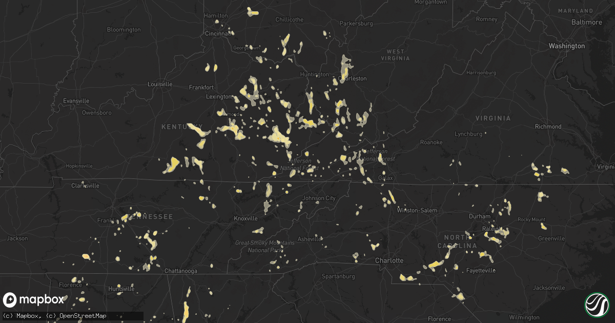
Hail Map in Georgia on July 5, 2012
Get this storm
July 5 map
$229
one time, instant access
Download today. No call, no setup
Keep the $229
Bought the map and want the full workflow? Apply the entire $229 to a subscription within 7 days. None of it is wasted.
Every map, not just this one
This buys you this map. Subscription and you get every map we run, in the markets you choose from a few cities to whole states to nationwide. Plus real-time alerts the moment a storm fires.
Contact data
Name, contact info, occupancy, even credit band for addresses in the footprint. You go from where it hit to who to call.
Become the source they trust
Unlimited branding weather history reports on demand. You already have the documented answer ready for the property owner, and you are the one who showed up with it.
Property data and RoofTrace estimates
Pull up any address you have got, its value and the exact code rules for that jurisdiction, straight from One Click Code. Then RoofTrace estimates the squares, pitch, and roof value, priced the way you price.
Storm reports in Georgia
Georgia
| Date | Description |
|---|---|
| 07/05/20126:54 PM CDT | Jasper 911 relayed a report of at least 6 trees and three powerlines down near jackson lake. Time is based on radar. |
| 07/05/20126:54 PM CDT | Butts county 911 relayed a report of at least three trees down near jackson lake. |
| 07/05/20126:50 PM CDT | A local report indicates 1.75 inch wind near 2 N ROME |
| 07/05/20126:46 PM CDT | A local report indicates 1.00 inch wind near ROME |
| 07/05/20126:45 PM CDT | Trained spotter relayed a report of penny sized hail along with numerous trees and powerlines down. |
| 07/05/20126:40 PM CDT | Numerous reports of quarter sized hail in the armuchee area. |
| 07/05/20126:35 PM CDT | Trees down all over rabun county starting near dillard at 735 pm and reaching the southern border around 8 pm. |
| 07/05/20126:29 PM CDT | Trees down off washington road at woodbine. |
| 07/05/20126:27 PM CDT | Trees down on jonathan circle and off mike padgett highway. |
| 07/05/20126:08 PM CDT | A tree was blown down along pleasant hill road. |
| 07/05/20126:07 PM CDT | A tree was blown down at the intersection of old portal road and denver lanier road. |
| 07/05/20126:06 PM CDT | Us forest service firefighters relayed a report of hail to the size of nickels and many trees down just east of villanow. The crews are using chainsaws to remove all of |
| 07/05/20126:06 PM CDT | A tree was blown down along old dill road. |
| 07/05/20126:04 PM CDT | A tree was blown down on claudia street. |
| 07/05/20126:03 PM CDT | A tree was blown down at intersection of highway 80 west and lotts road. |
| 07/05/20125:04 PM CDT | Thunderstorm winds blew down a power line at the intersection of highway 21 and mccall road. Time was estimated from radar data. |
| 07/05/20124:55 PM CDT | 1 tree down along hwy 520 east of louvale and north of brooklyn. |
| 07/05/20124:30 PM CDT | 10 to 20 trees down across columbus...mainly over the south part of the city. At least 10 power lines down. 1 tree down on wynnton road. 1 tree on house on matthew stre |
| 07/05/20124:20 PM CDT | Quarter size hail in and around the city of preston. |
| 07/05/20123:50 PM CDT | 6 to 8 trees down along highway 26 just west of buena vista. Power lines also down in this area. 1 tree across pineville road about 1 mile southwest of buena vista. |
| 07/05/20123:50 PM CDT | 4 trees down along highway 45 north of plains. |
| 07/05/20123:48 PM CDT | Trees down along big hill road. Time estimated from radar. Public report relayed by broadcast media. |
| 07/04/20129:25 PM CDT | 1 tree down on pinfield road and 1 tree down on veazey road. |
| 07/04/20129:15 PM CDT | 4 trees down in maxeys area. 1 power line down down in crawford area. |
| 07/04/20128:55 PM CDT | Trees and power lines were blown down near the intersection of scarboro highway and dixon branch road. Time was estimated from radar. |
| 07/04/20128:29 PM CDT | Trees were blown down along bay branch road. Time was estimated from radar. |
| 07/04/20128:24 PM CDT | Numerous trees and power lines down in millen. Time estimated from radar. |
| 07/04/20128:16 PM CDT | Tree down across harmony road off of highway 301. Time estimated from radar. |
| 07/04/20128:15 PM CDT | Several power lines down across highfalls road west of forsyth. House high by lightning on johnsonvile road. |
| 07/04/20128:15 PM CDT | Several powerlines down around mott road about 6 miles east of barnesville. |
| 07/04/20128:00 PM CDT | 6 to 7 trees down and several power lines down in and around the summerville area. |
| 07/04/20127:55 PM CDT | Bartow 911 relayed a report of 10 to 15 trees down countywide from the storms. Time was estimated based on radar. |
| 07/04/20127:50 PM CDT | Fire chief reported a tree down on a house. |
| 07/04/20127:48 PM CDT | One tree down and a couple powerlines down. |
| 07/04/20127:40 PM CDT | Fire chief reported a tree down on a house. |
| 07/04/20127:30 PM CDT | Trees were blown down along parker road. Time was estimated from radar. |
| 07/04/20127:25 PM CDT | Public reports a tree on their house causing roof damage along with several other trees down. |
| 07/04/20127:19 PM CDT | Ema director relayed a report of multiple trees down county wide along with some structure damage and damage to boats at carters lake. |
| 07/04/20127:15 PM CDT | Emergency manager reported 6 trees down along/near the ga hwy 85 connector. |
| 07/04/20127:05 PM CDT | 2 trees down 5 miles east of owltown. |
| 07/04/20127:00 PM CDT | 2 trees down in the macedonia area. |
| 07/04/20127:00 PM CDT | 1 large tree down west of gibson. |
All States Impacted by Hail Map on July 5, 2012
Cities Impacted by Hail Map on July 5, 2012
- Deerwood, MN
- Aitkin, MN
- Halifax, NC
- Sundance, WY
- Stockbridge, MI
- Smyrna, TN
- Murfreesboro, TN
- Mount Berry, GA
- Rome, GA
- Armuchee, GA
- Lindale, GA
- Gillette, WY
- Robbins, NC
- Garner, NC
- Clayton, NC
- Raleigh, NC
- Smithfield, NC
- Union Point, GA
- Raleigh, MS
- Greensboro, GA
- Salyersville, KY
- Gunlock, KY
- Royalton, KY
- Pound, VA
- Wise, VA
- Georgetown, OH
- Russellville, OH
- Salem, AL
- Windsor, KY
- Dunnville, KY
- Kings Mountain, KY
- Liberty, KY
- Waynesburg, KY
- Yosemite, KY
- Bethelridge, KY
- Mcdonough, GA
- Conyers, GA
- Whitesburg, KY
- Thornton, KY
- McKee, KY
- Berea, KY
- Iron Station, NC
- Denver, NC
- Springville, AL
- Odenville, AL
- Henderson, NC
- Mcminnville, TN
- Belle Fourche, SD
- Ostrander, OH
- Marysville, OH
- Grover, NC
- Shelby, NC
- Prestonsburg, KY
- Moncure, NC
- Sanford, NC
- Warfield, VA
- Dolphin, VA
- Monticello, GA
- Jackson, GA
- Tyner, KY
- Annville, KY
- Marston, NC
- Rockingham, NC
- Hazel Green, KY
- Mount Gilead, NC
- Ellerbe, NC
- Wartburg, TN
- Lancing, TN
- Decherd, TN
- Glenrock, WY
- Jackson, KY
- Inez, KY
- Louisa, KY
- Warfield, KY
- Fort Gay, WV
- Genoa, WV
- Pilgrim, KY
- Crum, WV
- Morrison, TN
- Manchester, TN
- Fairburn, SD
- Cobbtown, GA
- Nauvoo, AL
- Eldridge, AL
- Carthage, NC
- Eagle Springs, NC
- West End, NC
- Jackson Springs, NC
- Lawrenceburg, TN
- Phenix City, AL
- Columbus, GA
- Lillington, NC
- Jamestown, TN
- Deer Lodge, TN
- Varney, KY
- Pikeville, KY
- Independence, VA
- Mouth Of Wilson, VA
- Saulsville, WV
- Nancy, KY
- Monticello, KY
- Williamson, WV
- Belfry, KY
- Lincolnton, NC
- Corinth, KY
- Williamstown, KY
- Edmonton, KY
- Wall, SD
- Carrie, KY
- Plains, GA
- Gardners, PA
- Rogersville, TN
- Eidson, TN
- Portsmouth, OH
- Wheelersburg, OH
- Milford, OH
- Batavia, OH
- Edgefield, SC
- Model, CO
- Lusk, WY
- Pelahatchie, MS
- Gibsland, LA
- Dupree, SD
- Edgemont, SD
- McDermott, OH
- West Portsmouth, OH
- Evarts, KY
- Baxter, KY
- Harlan, KY
- Ages Brookside, KY
- Centreville, MD
- Crofton, NE
- Senoia, GA
- Sharpsburg, GA
- Eaton Rapids, MI
- Barbourville, KY
- Fort Deposit, AL
- Honoraville, AL
- Upperco, MD
- Sparks Glencoe, MD
- Manchester, MD
- Parkton, MD
- Selma, AL
- Garrison, KY
- Vanceburg, KY
- Buffalo Gap, SD
- Pelham, TN
- Monteagle, TN
- Stanville, KY
- Banner, KY
- Kimper, KY
- Ronda, NC
- Auburn, AL
- Auburn University, AL
- Wilmington, OH
- Calera, AL
- Crosby, MS
- Natchez, MS
- Four Oaks, NC
- Hephzibah, GA
- Edwards, MS
- Greer, SC
- Duncan, SC
- Kiahsville, WV
- Ranger, WV
- Branchland, WV
- Harts, WV
- Nederland, CO
- Boulder, CO
- Golden, CO
- Coeburn, VA
- Lapine, AL
- Ramer, AL
- Hope Hull, AL
- Letohatchee, AL
- Montgomery, AL
- Glendo, WY
- Saint Albans, WV
- Nitro, WV
- Hayden, CO
- Vincent, AL
- Westphalia, MI
- Weldon, NC
- Jackson, NC
- Bluffton, GA
- Edison, GA
- Fort Gaines, GA
- Moorcroft, WY
- Andersonville, GA
- Jeff, KY
- Happy, KY
- Viper, KY
- Hazard, KY
- Niceville, FL
- Winnsboro, LA
- Gilbert, LA
- Van Lear, KY
- Paintsville, KY
- Hagerhill, KY
- Auxier, KY
- East Point, KY
- El Dorado, AR
- Rowland, NC
- Maxton, NC
- Verner, WV
- Man, WV
- Fort Stockton, TX
- Girard, GA
- Sardis, GA
- Myrtle Beach, SC
- Fort Mill, SC
- Seale, AL
- Pittsview, AL
- Garrett, WY
- Jackson, SC
- West Union, OH
- Clayton, MI
- Morenci, MI
- Gravel Switch, KY
- Hustonville, KY
- Middleburg, KY
- Bradfordsville, KY
- Lebanon, KY
- Custer, SD
- Swainsboro, GA
- Twin City, GA
- Shawnee, WY
- Sevierville, TN
- Utica, MS
- Opelika, AL
- Lucasville, OH
- Piketon, OH
- Leburn, KY
- Vest, KY
- Hueysville, KY
- Wheatland, WY
- Dimondale, MI
- Charlotte, MI
- Spearfish, SD
- Abbeville, AL
- Shorterville, AL
- Milesville, SD
- Ashville, AL
- Rockford, OH
- Willshire, OH
- Wake Forest, NC
- Creedmoor, NC
- Mount Sterling, KY
- Sharpsburg, KY
- Saluda, SC
- Newberry, SC
- Silverstreet, SC
- Johnstown, CO
- Columbiana, AL
- Wapakoneta, OH
- Lakeview, OH
- Lewistown, OH
- Luverne, MN
- Steen, MN
- Roxboro, NC
- Appomattox, VA
- Frenchburg, KY
- Denniston, KY
- Wellington, KY
- Salt Lick, KY
- Roaring River, NC
- Elkin, NC
- Watertown, TN
- Milton, TN
- Rock Rapids, IA
- Midway, AL
- Eufaula, AL
- Clayton, AL
- Ellsworth, MN
- Wingate, NC
- Marshville, NC
- Tyler, AL
- Cusseta, GA
- Flat Lick, KY
- Ethridge, TN
- Mendenhall, MS
- Buffalo, SD
- Cowan, TN
- Sewanee, TN
- Winchester, TN
- Duff, TN
- La Follette, TN
- Amherstdale, WV
- Cyclone, WV
- Brenton, WV
- Clear Fork, WV
- Coal Mountain, WV
- Bim, WV
- Davin, WV
- Oneonta, AL
- Steele, AL
- Langsville, OH
- Pomeroy, OH
- Rutland, OH
- Leon, WV
- Red House, WV
- Martin, SC
- Pelham, AL
- Fordyce, NE
- Tyndall, SD
- Linton, ND
- Danville, VA
- Barnesville, GA
- Forsyth, GA
- Petersburg, TN
- Lebanon, TN
- Lascassas, TN
- Jonesville, NC
- Rutledge, TN
- Sneedville, TN
- Thorn Hill, TN
- Tazewell, TN
- Harrogate, TN
- Safford, AL
- Marion Junction, AL
- Uniontown, AL
- Red Level, AL
- Clay City, KY
- Stanton, KY
- Hayden, AL
- Blountsville, AL
- Freeport, FL
- Hartville, WY
- Bradyville, TN
- Sylva, NC
- Dublin, OH
- Plain City, OH
- Beech Island, SC
- Maben, WV
- Glen Fork, WV
- Pineville, WV
- Oceana, WV
- Ravencliff, WV
- Hamilton, AL
- Vicksburg, MS
- Millen, GA
- Jarratt, VA
- Dryden, TX
- Whitman, NE
- Merriman, NE
- Newville, AL
- Headland, AL
- Avon, SD
- Scotland, SD
- Ary, KY
- Buckhorn, KY
- Rowdy, KY
- Chavies, KY
- Dwarf, KY
- Hindman, KY
- Bonnyman, KY
- Vicco, KY
- Bulan, KY
- Sassafras, KY
- Gays Creek, KY
- Clayhole, KY
- Emmalena, KY
- Littcarr, KY
- Krypton, KY
- Lost Creek, KY
- Winchester, OH
- Highlands, NC
- Courtland, VA
- Sedley, VA
- Franklin, VA
- Hazlehurst, MS
- Owingsville, KY
- Hillsboro, KY
- Mullens, WV
- New Richmond, WV
- Sophia, WV
- Herndon, WV
- Itmann, WV
- Glen Daniel, WV
- Slab Fork, WV
- Glen White, WV
- Fairdale, WV
- Surveyor, WV
- Crab Orchard, WV
- Amigo, WV
- Beckley, WV
- Lester, WV
- San Luis, CO
- Bigelow, MN
- Worthington, MN
- Boonville, NC
- State Road, NC
- Dobson, NC
- Louisburg, NC
- Griffithsville, WV
- Alkol, WV
- Ashby, MN
- Ponce De Leon, FL
- Ricetown, KY
- Guernsey, WY
- Midville, GA
- Manville, WY
- Springport, MI
- Scott Depot, WV
- Kenna, WV
- Tornado, WV
- Winfield, WV
- Sod, WV
- Given, WV
- Buffalo, WV
- Poca, WV
- Dunbar, WV
- Charleston, WV
- Alum Creek, WV
- South Charleston, WV
- Liberty, WV
- Jamestown, KY
- Russell Springs, KY
- Beechgrove, TN
- Sandersville, GA
- Byrdstown, TN
- Albany, KY
- Booneville, KY
- Leslie, MI
- Mason, MI
- Lance Creek, WY
- Bastian, VA
- Sugar Grove, VA
- Sicily Island, LA
- Randolph, AL
- Lawley, AL
- Osyka, MS
- Jemison, AL
- Thorsby, AL
- Claxton, GA
- Metter, GA
- Collins, GA
- Tallulah, LA
- Bandy, VA
- Alzada, MT
- Elora, TN
- Flintville, TN
- Iron City, TN
- Westpoint, TN
- Cedar Bluff, VA
- La Vergne, TN
- Lynchburg, SC
- Sylvania, GA
- Ruby, SC
- Chesterfield, SC
- Peachland, NC
- Emporia, VA
- Cave Spring, GA
- Mount Vernon, KY
- Brodhead, KY
- Raymond, MS
- Greenville, GA
- Lagrange, GA
- Hogansville, GA
- Clopton, AL
- Greeneville, TN
- Lancaster, KY
- Richmond, KY
- Freeman, VA
- Dunn, NC
- Roaring Gap, NC
- Glade Valley, NC
- Chatham, LA
- Gate City, VA
- Hiltons, VA
- Kingsport, TN
- Alabaster, AL
- Hamlin, WV
- Hurricane, WV
- Huntsville, AL
- Sadieville, KY
- Clanton, AL
- Augusta, GA
- Surgoinsville, TN
- Milan, MI
- Maybee, MI
- Dubberly, LA
- Arcadia, LA
- Yolyn, WV
- Stollings, WV
- Lyburn, WV
- Cleveland, AL
- Wauseon, OH
- Delta, OH
- Hudson, MI
- Lyons, OH
- Dansville, MI
- Galax, VA
- Candor, NC
- Eagle, MI
- Carey, OH
- Alvada, OH
- Vanlue, OH
- Swannanoa, NC
- Burkesville, KY
- Breeding, KY
- Columbia, KY
- Apex, NC
- Harpersville, AL
- Altoona, AL
- Attalla, AL
- Gallant, AL
- Houston, DE
- Greenwood, DE
- Covington, GA
- Mansfield, GA
- Grass Lake, MI
- Otto, NC
- Middlesex, NC
- Knightdale, NC
- Zebulon, NC
- Wendell, NC
- Selma, NC
- Rock River, WY
- Dungannon, VA
- Hot Springs, SD
- Rocky Face, GA
- Rives Junction, MI
- Jackson, MI
- Pigeon Forge, TN
- Costilla, NM
- Arrington, TN
- Nolensville, TN
- Andalusia, AL
- Monroe, NC
- Gatlinburg, TN
- Clarksville, TN
- Laurel Hill, NC
- Hartford, AL
- Black, AL
- West Liberty, KY
- Livingston, TN
- Rickman, TN
- Rock Hill, SC
- Cary, NC
- Holly Springs, NC
- Fuquay Varina, NC
- Jones, AL
- Billingsley, AL
- Highland Home, AL
- Wagner, SD
- Delmont, SD
- Newcastle, WY
- Columbia, TN
- Kelso, TN
- Louisville, GA
- Aberdeen, NC
- Southern Pines, NC
- Cody, NE
- Eagleville, TN
- Chelsea, AL
- Lake, WV
- Hewett, WV
- Smyrna, SC
- Blacksburg, SC
- Tracy City, TN
- Glens Fork, KY
- Sabina, OH
- Flemingsburg, KY
- La Fayette, GA
- Summerville, GA
- Autryville, NC
- Walland, TN
- Townsend, TN
- Hermosa, SD
- Iaeger, WV
- Gary, IN
- Griffith, IN
- Merrillville, IN
- Walker, KY
- Toledo, OH
- Sylvania, OH
- Campton, KY
- Franklinton, NC
- Youngsville, NC
- Warthen, GA
- Lexington, GA
- Crawford, GA
- Parma, MI
- Lawrenceville, GA
- Dacula, GA
- Bonifay, FL
- Lake City, SC
- New Zion, SC
- Kingstree, SC
- Brookhaven, MS
- Nickelsville, VA
- Fort Blackmore, VA
- Benton, TN
- Ezel, KY
- Holmes Mill, KY
- Allendale, SC
- Itta Bena, MS
- Fayetteville, GA
- Hampton, GA
- Tarboro, NC
- Aiken, SC
- Loganville, GA
- Fedscreek, KY
- Greensboro, MD
- Harrington, DE
- Beattyville, KY
- Pounding Mill, VA
- Honaker, VA
- Saltville, VA
- Hulett, WY
- Grovetown, GA
- Waverly, OH
- Otway, OH
- Cullowhee, NC
- Ferguson, NC
- Phil Campbell, AL
- Russellville, AL
- Mitchell, GA
- Cochran, GA
- Magnolia, MN
- Troy, AL
- Spirit Lake, IA
- Paisley, FL
- Pulaski, TN
- Stopover, KY
- Matewan, WV
- Baisden, WV
- Wharncliffe, WV
- Hurley, VA
- Majestic, KY
- Gilbert, WV
- Pittsboro, NC
- Barnwell, SC
- Elkfork, KY
- Rougemont, NC
- Hurdle Mills, NC
- Waynesboro, GA
- Blythe, GA
- Neeses, SC
- North, SC
- Elbow Lake, MN
- Brooks, GA
- Moulton, AL
- Church Hill, MD
- Chestertown, MD
- Pecks Mill, WV
- Logan, WV
- Cedar Bluff, AL
- Double Springs, AL
- Haleyville, AL
- Winchester, KY
- Bartow, GA
- Wadley, GA
- Irvine, KY
- New Haven, IN
- Welch, WV
- Crab Orchard, KY
- Newellton, LA
- Evansville, MN
- Spearsville, LA
- Junction City, AR
- Strong, AR
- Cincinnati, OH
- Volin, SD
- Irene, SD
- Skipperville, AL
- Gaffney, SC
- Hoffman, NC
- Pensacola, FL
- Okabena, MN
- Lenoir, NC
- Woodville, MS
- Hallie, KY
- Linefork, KY
- Deep Gap, NC
- Cowpens, SC
- Ripley, WV
- Mize, KY
- Town Creek, AL
- Mount Hope, AL
- Capitol, MT
- Fort Benning, GA
- Chicago, IL
- Vermontville, MI
- Lake Odessa, MI
- Mulliken, MI
- Sunfield, MI
- Dublin, VA
- Max Meadows, VA
- Wytheville, VA
- Davisboro, GA
- Warrior, AL
- Dallas, NC
- Chatsworth, GA
- Ellijay, GA
- Perkins, GA
- McBee, SC
- Sandy Hook, KY
- Ohio City, OH
- Hartington, NE
- Findlay, OH
- Arcadia, OH
- Fostoria, OH
- Wharton, OH
- Bloomdale, OH
- Mount Blanchard, OH
- Hillsboro, TN
- Homer, LA
- East Waterford, PA
- Fort Wayne, IN
- Tylertown, MS
- Aladdin, WY
- Ivel, KY
- Deerfield, IL
- Lincolnshire, IL
- Magee, MS
- Pinola, MS
- Woodruff, SC
- Lansing, MI
- Holt, MI
- Danville, WV
- Clothier, WV
- Henlawson, WV
- Jeffrey, WV
- Chapmanville, WV
- Fort Bragg, NC
- Oak Hill, OH
- Jackson, OH
- New Bloomington, OH
- Morral, OH
- La Rue, OH
- Wooton, KY
- Cuthbert, GA
- Timmonsville, SC
- Marion, NC
- Polkton, NC
- Olympia, KY
- Florence, AL
- Wendell, MN
- Ward, CO
- Buffalo Grove, IL
- Franklin, NC
- Pleasant Lake, MI
- Dongola, IL
- Ottawa Lake, MI
- Holland, OH
- Riga, MI
- Libertyville, IL
- Lake Forest, IL
- Newton, NC
- Loveland, CO
- Winnetka, IL
- Glencoe, IL
- Athens, LA
- Georgetown, GA
- Big Spring, TX
- Garden City, TX
- Black Mountain, NC
- Carlsbad, NM
- Alberta, AL
- Rupert, GA
- Victoria, VA
- Bell Buckle, TN
- Christiana, TN
- Rose Hill, VA
- Jay Em, WY
- Buena Vista, GA
- Orrville, AL
- Lewisville, NC
- Taylors, SC
- Clio, AL
- Americus, GA
- Sunbright, TN
- Bethune, SC
- Beaver Creek, MN
- Maplesville, AL
- Owenton, KY
- Chandlersville, OH
- Williston, SC
- Kittrell, NC
- Hickory, NC
- Jolo, WV
- Panther, WV
- Rockford, AL
- Verbena, AL
- Crossville, TN
- Grundy, VA
- Potterville, MI
- Fairfield, OH
- Collinwood, TN
- Yawkey, WV
- Albany, OH
- Goodwater, AL
- Montevallo, AL
- Lilesville, NC
- Marion, VA
- Unicoi, TN
- Jonesborough, TN
- Morehead, KY
- Stephens, GA
- Thomaston, AL
- Fairmont, NC
- Plantersville, AL
- Stanton, AL
- Joppa, AL
- Beulah, WY
- Sherrills Ford, NC
- Delbarton, WV
- Wayne, WV
- Defuniak Springs, FL
- Notasulga, AL
- Tuskegee, AL
- Tuskegee Institute, AL
- Jonesville, MI
- Huddy, KY
- Hardy, KY
- Upper Sandusky, OH
- Forest, OH
- Tannersville, VA
- Kanaranzi, MN
- Ozona, TX
- Nicholasville, KY
- Rockvale, TN
- Cherokee, NC
- Deland, FL
- Manchester, OH
- Warrenton, NC
- Macclesfield, NC
- Greenville, NC
- Holly Pond, AL
- Granby, CO
- Speedwell, TN
- New Tazewell, TN
- Cumberland Gap, TN
- Rogersville, AL
- Pioneer, TN
- Gretna, VA
- Chatham, VA
- Morristown, TN
- Bean Station, TN
- Frakes, KY
- Griffin, GA
- Tuscumbia, AL
- Tazewell, VA
- Broadford, VA
- Gaston, SC
- Swansea, SC
- Moore, SC
- Old Fort, NC
- Ceres, VA
- Atkins, VA
- Troutdale, VA
- Kaycee, WY
- Glasgow, KY
- Dawsonville, GA
- Sidney, KY
- Canada, KY
- Forest Hills, KY
- Stone, KY
- Lebanon, VA
- Bledsoe, KY
- Helton, KY
- Robertsdale, AL
- Lamy, NM
- Chapel Hill, TN
- Greenville, AL
- Mauk, GA
- Grand Ledge, MI
- Warbranch, KY
- East Bend, NC
- Lumpkin, GA
- Glenview, IL
- Des Plaines, IL
- Mount Prospect, IL
- Georgetown, SC
- Richland, GA
- Douglas, WY
- Warrenville, SC
- Graniteville, SC
- Catherine, AL
- Canton, MS
- Fries, VA
- Eglin Afb, FL
- Robbins, TN
- Castlewood, VA
- Raccoon, KY
- Dana, KY
- Harold, KY
- Dwale, KY
- Betsy Layne, KY
- Allen, KY
- Savannah, GA
- Milner, GA
- Pine Mountain, GA
- Camden, AR
- Louann, AR
- Liberty, SC
- Easley, SC
- Sulligent, AL
- Beaverton, AL
- Tompkinsville, KY
- Martin, KY
- Vancleve, KY
- Princeton, WV
- Lerona, WV
- Ball Ground, GA
- Bunnlevel, NC
- Godwin, NC
- Erwin, NC
- Linden, NC
- Navarre, FL
- Norwich, OH
- Blue Rock, OH
- Zanesville, OH
- Grayson, GA
- Richwood, OH
- Raymond, OH
- Partridge, KY
- Eolia, KY
- Kermit, WV
- Alton, VA
- Milton, NC
- Hanover, WV
- Greenville, SC
- Buford, GA
- Suwanee, GA
- Brevard, NC
- Carlisle, KY
- Mount Pleasant, TN
- Anna, IL
- Chuckey, TN
- Afton, TN
- Stanford, KY
- Pembroke, GA
- Waco, KY
- Enfield, NC
- Roanoke Rapids, NC
- Hartsville, SC
- Eastman, GA
- Oneida, TN
- Kershaw, SC
- Meadowview, VA
- Evans, GA
- Portland, MI
- Yanceyville, NC
- Summer Shade, KY
- Sparta, GA
- Enning, SD
- Howes, SD
- Chiefland, FL
- South Pittsburg, TN
- Duffield, VA
- Eros, LA
- Marlette, MI
- Hardaway, AL
- Pell City, AL
- Midkiff, WV
- Bishopville, SC
- Semora, NC
- Cameron, SC
- Huntington, WV
- Willow Spring, NC
- Lexington, AL
- Estancia, NM
- Huntland, TN
- Stony Creek, VA
- Terry, MS
- White Owl, SD
- Pittsville, VA
- Lily, KY
- Arlington, OH
- Childersburg, AL
- Oxford, NC
- Stem, NC
- Vermillion, SD
- Trenton, SC
- Ridge Spring, SC
- Baileyton, AL
- Butler, GA
- Sherwood, TN
- Belvidere, TN
- Sparta, NC
- Olive Hill, KY
- Cumberland, KY
- Gurley, AL
- Omaha, GA
- Idaho Springs, CO
- Munith, MI
- Amory, MS
- Aberdeen, MS
- Wrens, GA
- Chilhowie, VA
- Port Wentworth, GA
- Keystone, SD
- Rapid City, SD
- Preston, GA
- Gulf Breeze, FL
- Scuddy, KY
- Hyden, KY
- Redfox, KY
- Busy, KY
- Blackey, KY
- Combs, KY
- Union Church, MS
- Jefferson City, TN
- Talbott, TN
- New Market, TN
- Maiden, NC
- Edison, OH
- Mount Gilead, OH
- New Vienna, OH
- Pall Mall, TN
- Adrian, MN
- Pittsford, MI
- Yale, VA
- Westminster, MD
- Hampstead, MD
- Rocky Ford, GA
- Kingston, GA
- Moriarty, NM
- Jonesville, VA
- Dryden, VA
- Pennington Gap, VA
- Big Stone Gap, VA
- Blackwater, VA
- Blackstone, VA
- Quitman, LA
- Jonesboro, LA
- Raeford, NC
- Woodbury, TN
- Sylacauga, AL
- Ravenna, KY
- Flatgap, KY
- Oil Springs, KY
- Utica, SD
- Yankton, SD
- Ennice, NC
- Salem, SC
- Langley, KY
- Printer, KY
- Drift, KY
- Cartersville, GA
- White, GA
- Dandridge, TN
- Jefferson, SC
- Pageland, SC
- Cawood, KY
- Longmont, CO
- Franklin, TN
- Panama City Beach, FL
- Sorrento, FL
- Apopka, FL
- Taiban, NM
- Bland, VA
- Piney Creek, NC
- Grassy Creek, NC
- Crumpler, NC
- Antonito, CO
- Wilmont, MN
- Middleport, OH
- Monroe, LA
- Guyton, GA
- Boaz, AL
- Stockbridge, GA
- Abingdon, VA
- South Webster, OH
- Tuckasegee, NC
- Hatchechubbee, AL
- Lakefield, MN
- Wilsonville, AL
- Alpine, AL
- Collinsville, AL
- Manchester, MI
- Ragland, AL
- Parkston, SD
- Saint Matthews, SC
- New Underwood, SD
- Edgemoor, SC
- Hardeeville, SC
- Pooler, GA
- Killen, AL
- Fayetteville, TN
- Stapleton, GA
- Smilax, KY
- Gibson, GA
- McColl, SC
- Clio, SC
- Little Rock, SC
- Cullman, AL
- Broadway, NC
- Summertown, TN
- Magnolia, MS
- Scenic, SD
- Caputa, SD
- Jeffersonville, KY
- Moorefield, KY
- Means, KY
- Ewing, KY
- Hope, KY
- Altamont, TN
- Autaugaville, AL
- New Hill, NC
- Goliad, TX
- Kenedy, TX
- Meally, KY
- West Van Lear, KY
- Wesson, MS
- Lake Villa, IL
- Round Lake, IL
- Stanley, NM
- Goldston, NC
- Columbus, OH
- Powell, OH
- Milton, FL
- Cedartown, GA
- Ewing, VA
- Arlington, GA
- North Augusta, SC
- Culloden, WV
- Patrick, SC
- Cleveland, VA
- Faunsdale, AL
- Newbern, AL
- Swanton, OH
- Saint Paul, VA
- McComb, OH
- Deshler, OH
- Hoytville, OH
- Custar, OH
- North Baltimore, OH
- Yadkinville, NC
- Sand Creek, MI
- Jasper, MI
- Fayette, OH
- Union Springs, AL
- Skippers, VA
- South Shore, KY
- Greenup, KY
- Woodville, AL
- Saline, MI
- Sandgap, KY
- Roxana, KY
- Cornettsville, KY
- Fort Sumner, NM
- Rock Island, TN
- Kyle, WV
- Elkhorn, WV
- Northfork, WV
- Kings Mountain, NC
- Cherryville, NC
- North Spring, WV
- Niobrara, NE
- Worton, MD
- Wadesboro, NC
- Hilliard, OH
- Mount Hope, WV
- Maggie Valley, NC
- Tripp, SD
- Rushmore, MN
- Carbondale, CO
- Wheeling, IL
- Northbrook, IL
- Vernon Hills, IL
- Lawrenceville, VA
- Brandon, MN
- Richlands, VA
- Jewell Ridge, VA
- Weogufka, AL
- East Bernstadt, KY
- Detroit, AL
- Van Buren, OH
- Travelers Rest, SC
- Bristol, VA
- Mendota, VA
- Lake Lure, NC
- Franklinton, LA
- Alexandria, TN
- Fort Walton Beach, FL
- Hurlburt Field, FL
- Mary Esther, FL
- Horton, MI
- Hanover, MI
- Concord, MI
- Reva, SD


