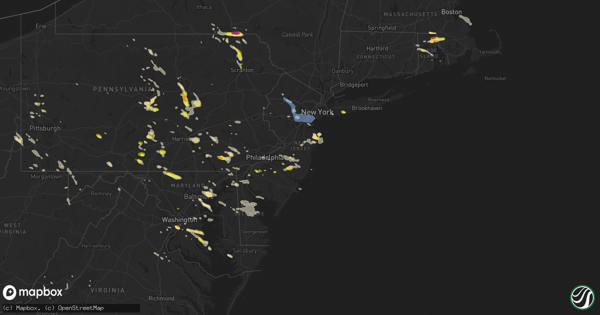
Hail Map in New Jersey on June 29, 2019
Get this storm
June 29 map
$229
one time, instant access
Download today. No call, no setup
Keep the $229
Bought the map and want the full workflow? Apply the entire $229 to a subscription within 7 days. None of it is wasted.
Every map, not just this one
This buys you this map. Subscription and you get every map we run, in the markets you choose from a few cities to whole states to nationwide. Plus real-time alerts the moment a storm fires.
Contact data
Name, contact info, occupancy, even credit band for addresses in the footprint. You go from where it hit to who to call.
Become the source they trust
Unlimited branding weather history reports on demand. You already have the documented answer ready for the property owner, and you are the one who showed up with it.
Property data and RoofTrace estimates
Pull up any address you have got, its value and the exact code rules for that jurisdiction, straight from One Click Code. Then RoofTrace estimates the squares, pitch, and roof value, priced the way you price.
Storm reports in New Jersey
New Jersey
| Date | Description |
|---|---|
| 06/29/20195:02 PM CDT | Weatherflow gauge. |
| 06/29/20194:46 PM CDT | Multiple trees down on homes with wires down throughout south toms river. |
| 06/29/20194:45 PM CDT | Several reports of trees and limbs down in eatontown. Time estimated from radar. |
| 06/29/20194:45 PM CDT | Several reports of trees and wires down in this area from 530 to 600 pm. Time based on a combination of radar... Nearby surface observations... And social media reports |
| 06/29/20194:40 PM CDT | Several downed trees... Branches... And power lines reported. Time estimated from radar. |
| 06/29/20194:38 PM CDT | Damage to an outdoor stage and equipment owing to thunderstorm winds. Time estimated from radar. |
| 06/29/20194:37 PM CDT | Golf ball size hail in west long branch. Time estimated from radar. |
| 06/29/20194:36 PM CDT | Time estimated from radar. |
| 06/29/20194:36 PM CDT | A local report indicates 61 MPH wind near SANDY HOOK |
| 06/29/20194:24 PM CDT | Tree down on john f kennedy boulevard with time estimated by radar |
| 06/29/20194:21 PM CDT | A local report indicates 68 MPH wind near PORT READING |
| 06/29/20194:18 PM CDT | Large tree uprooted and blow down in street |
| 06/29/20194:18 PM CDT | Numerous trees and wires down throughout cranford with time estimated by radar |
| 06/29/20194:18 PM CDT | Large branch off a magnolia tree broken and down in union |
| 06/29/20194:16 PM CDT | Large tree branches down at the intersection of west inman avenue and cornell avenue blocking the road with time estimated by radar |
| 06/29/20194:15 PM CDT | Downed tree on state highway 27 near new dover road. Time estimated from radar. |
| 06/29/20194:13 PM CDT | Report of a large tree down blocking both direction of middlesex avenue in metuchen. Time estimated from radar. |
| 06/29/20194:12 PM CDT | Large tree limbs and branches reported down with time estimated by radar |
| 06/29/20194:12 PM CDT | Trees reported down in westfield |
| 06/29/20194:12 PM CDT | A couple of trees down and branches down in backyard of home along raritan road |
| 06/29/20194:11 PM CDT | Trees split. Time estimated from radar. |
| 06/29/20194:10 PM CDT | Trees and branches reported down around town... Time estimated by radar |
| 06/29/20194:09 PM CDT | Reports of trees down near and west of estell manor. Time estimated from radar. |
| 06/29/20194:07 PM CDT | Photos of multiple trees down. Time estimated from radar. |
| 06/29/20194:06 PM CDT | Downed tree on state highway 68 near monmouth road. All lanes closed. Time estimated from radar. |
| 06/29/20194:06 PM CDT | Fort dix road closed between pointville road and odd fellows road from downed trees. Time estimated from radar. |
| 06/29/20194:05 PM CDT | Photo of several hardwood trees down in country lakes. Time estimated from radar. |
| 06/29/20194:00 PM CDT | Mping report of trees and power lines down at this location. Time estimated from radar. |
| 06/29/20193:57 PM CDT | A tree fell onto a house in mount holly. Time estimated from radar. |
| 06/29/20193:57 PM CDT | A few trees and branches taking power lines and a fence down on grand street |
| 06/29/20193:56 PM CDT | A tree and a few large limbs down. Time estimated from radar. |
| 06/29/20193:56 PM CDT | Downed tree on interstate 287 northbound ramp to exit 36. Time estimated from radar. |
| 06/29/20193:55 PM CDT | Photos of several trees down in the area. Time estimated from radar. |
| 06/29/20193:54 PM CDT | Mping report of tree limbs down and property damage from thunderstorm damage at this location. Time estimated from radar. |
| 06/29/20193:47 PM CDT | Photo of a large tree down over a roadway and limb down on a car. Time estimated from radar. |
| 06/29/20193:46 PM CDT | Downed tree at a residence. Time estimated from radar. |
| 06/29/20193:42 PM CDT | A large tree uprooted and brought down on top of power lines with time estimated by radar |
| 06/29/20193:36 PM CDT | Downed tree on u.s. Highway 46 eastbound near main street. All lanes closed. Time estimated from radar. |
| 06/29/20193:34 PM CDT | Downed tree on state highway 10 eastbound near main street. All lanes closed. Time estimated from radar. |
| 06/29/20193:34 PM CDT | Trees and large tree limbs down. Time estimated from radar. |
| 06/29/20193:34 PM CDT | Multiple photos and reports of power lines down. Time estimated from radar. |
| 06/29/20193:32 PM CDT | Mping report of tree limbs down and property damage from thunderstorm winds at this location. Time estimated from radar. |
| 06/29/20193:30 PM CDT | Downed tree on u.s. Highway 206 north of interstate 80. All lanes closed. Time estimated from radar. |
| 06/29/20193:29 PM CDT | Private weather station. |
| 06/29/20193:28 PM CDT | Downed tree near the intersection of pleasant grove road and stephenburg road. Time estimated from radar. |
| 06/29/20193:22 PM CDT | Photo of a large tree down. Time estimated from radar. |
| 06/29/20193:20 PM CDT | Telephone poles and wires down. |
| 06/29/20193:06 PM CDT | Downed tree on u.s. Highway 22 near memorial parkway. Time estimated from radar. |
| 06/29/20193:00 PM CDT | Downed tree near the intersection of hudson street and washington street. Time estimated from radar. |
| 06/29/20192:42 PM CDT | Numerous trees reported down in the area. Time estimated from radar. |
| 06/29/20192:40 PM CDT | A local report indicates 1.00 inch wind near 1 NNE SOUTH HARRISON TW |
| 06/29/20192:40 PM CDT | Two trees blown down. |
| 06/29/20192:17 PM CDT | Photo showing nickel to quarter size hail. |
| 06/29/201912:43 AM CDT | At 543 PM EDT, severe thunderstorms were located along a line extending from Allenwood to Somers Point, moving east at 35 mph. HAZARD...60 mph wind gusts. SOURCE...Radar indicated. IMPACT...Damage to roofs, siding, trees, and power lines is possible. Locations impacted include... Toms River, Atlantic City, Ocean City, Lakewood, Barnegat, Pleasantville, Beachwood, Somers Point, Ventnor City, Brigantine, Northfield, Absecon, Margate City, Manasquan, Point Pleasant Beach, Tuckerton, Seaside Heights, Estell Manor, Surf City and Port Republic.People attending Vanns Warped Tour at Atlantic City should seek safeshelter immediately! |
| 06/29/201912:32 AM CDT | At 532 PM EDT, severe thunderstorms were located along a line extending from near Huguenot to near Vista Center, moving east at 45 mph. HAZARD...60 mph wind gusts and penny size hail. SOURCE...Radar indicated. IMPACT...Damage to roofs, siding, trees, and power lines is possible. Locations impacted include... Long Branch, Asbury Park, Sandy Hook, Middletown, Howell, Marlboro, Tinton Falls, Holmdel, Red Bank, Matawan, Highlands, Farmingdale, Allenwood, East Freehold, Six Flags Theme Park, West Freehold, Adelphia, Vista Center, Yorketown and Elberon. |
| 06/29/201912:08 AM CDT | At 508 PM EDT, a severe thunderstorm was located over Dividing Creek, or 9 miles south of Millville, moving east at 40 mph. HAZARD...60 mph wind gusts. SOURCE...Radar indicated. IMPACT...Damage to roofs, siding, trees, and power lines is possible. Locations impacted include... Vineland, Millville, Ocean City, Cape May, Cumberland, Somers Point, North Wildwood, Laurel Lake, Wildwood Crest, Woodbine, Sea Isle City, Estell Manor, Avalon, West Cape May, Stone Harbor, Corbin City, Newport, Cape May Court House, Leesburg and Scotch Bonnet. |
| 06/29/201912:05 AM CDT | At 504 PM EDT, a severe thunderstorm was located over Presidential Lakes Estates, or 18 miles west of Toms River, moving east at 20 mph. This replaces the previous severe thunderstorm warning in effect for the area. HAZARD...70 mph wind gusts and quarter size hail. SOURCE...Radar indicated. IMPACT...Minor damage to vehicles is possible. Expect considerable tree damage. Wind damage is also likely to mobile homes, roofs, and outbuildings. Locations impacted include... Toms River, Lakewood, Jackson, Barnegat, Beachwood, Tabernacle, Shamong, Manasquan, Point Pleasant Beach, Presidential Lakes Estates, Seaside Heights, Lakehurst, Pemberton, Surf City, Wrightstown, Mantoloking, Allenwood, Atsion, Six Flags Theme Park and Leisuretowne. |
| 06/29/201912:03 AM CDT | At 502 PM EDT, a severe thunderstorm was located over Society Hill, or near New Brunswick, moving east at 25 mph. HAZARD...60 mph wind gusts and quarter size hail. SOURCE...Radar indicated. IMPACT...Damage to vehicles is possible. Wind damage to roofs, siding, trees, and power lines is possible. Locations impacted include... New Brunswick, Perth Amboy, Somerset, Edison, East Brunswick, Carteret, Middlesex, Bound Brook, Colonia, Martinsville, Society Hill, North Brunswick Township, Woodbridge, South Plainfield, North Plainfield, Highland Park, Metuchen, Dunellen, Watchung and South Bound Brook. |
| 06/28/201911:59 PM CDT | At 458 PM EDT, a severe thunderstorm was located over Madison, or over Morristown, moving southeast at 40 mph. HAZARD...60 mph wind gusts. SOURCE...Radar indicated. IMPACT...Expect damage to trees and power lines. This severe thunderstorm will be near... Summit around 510 PM EDT. Plainfield and Millburn around 515 PM EDT. Clark and Union around 525 PM EDT. Newark and Elizabeth around 535 PM EDT. Bayonne and Todt Hill around 545 PM EDT. Huguenot around 550 PM EDT. The Verrazano Narrows Bridge and Tompkinsville around 555 PM EDT. |
| 06/28/201911:53 PM CDT | At 453 PM EDT, a severe thunderstorm was located over Morris Plains, or near Morristown, moving southeast at 30 mph. HAZARD...70 mph wind gusts. SOURCE...Radar indicated. IMPACT...Expect considerable tree damage. Damage is likely to mobile homes, roofs, and outbuildings. Locations impacted include... Morristown, Dover, Madison, Florham Park, East Hanover, Chatham, Boonton, Wharton, Rockaway, Morris Plains, Mendham, Mountain Lakes, Victory Gardens, Parsippany, Bernardsville, White Meadow Lake and Hanover Township. |
| 06/28/201911:27 PM CDT | At 426 PM EDT, a severe thunderstorm was located over Bloomfield, moving east at 35 mph. HAZARD...60 mph wind gusts and penny size hail. SOURCE...Radar indicated. IMPACT...Expect damage to trees and power lines. This severe thunderstorm will be near... Paterson around 430 PM EDT. Bloomfield around 435 PM EDT. Passaic around 440 PM EDT. Harrison around 445 PM EDT. Lyndhurst and Rutherford around 450 PM EDT. Hackensack and Kearny around 455 PM EDT. Secaucus around 500 PM EDT. Jersey City and Ridgefield around 505 PM EDT. Union City and Englewood around 510 PM EDT. Fort Lee around 515 PM EDT. |
| 06/28/201911:27 PM CDT | At 427 PM EDT, a severe thunderstorm was located over Budd Lake, or 10 miles south of Newton, moving southeast at 30 mph. HAZARD...60 mph wind gusts and quarter size hail. SOURCE...Radar indicated. IMPACT...Minor damage to vehicles is possible. Wind damage to roofs, siding, trees, and power lines is possible. Locations impacted include... Morristown, Madison, Hackettstown, Morris Plains, Mendham, Stanhope, Netcong, Peapack And Gladstone, Chester, Far Hills, Allamuchy-Panther Valley, Succasunna, Succasunna-Kenvil, Long Valley, Budd Lake, Millington, Basking Ridge, Beatyestown, Bernardsville and Beattyestown. |
| 06/28/201911:25 PM CDT | At 425 PM EDT, a severe thunderstorm was located over Lumberton, or 15 miles east of Camden, moving east at 30 mph. HAZARD...60 mph wind gusts and quarter size hail. SOURCE...Radar indicated. IMPACT...Minor damage to vehicles is possible. Wind damage to roofs, siding, trees, and power lines is possible. Locations impacted include... Medford, Lumberton, Mount Holly, Presidential Lakes Estates, Pemberton, Wrightstown, Presidential Lakes, Cedar Glen Lakes, Whiting, Browns Mills, Leisuretowne, Chatsworth, Old Halfway, Country Lake Estates, Nws Office, Pemberton Heights, Fort Dix and Crestwood Village. |
| 06/28/201911:23 PM CDT | At 423 PM EDT, a severe thunderstorm was located over Presidential Lakes Estates, or 19 miles west of Toms River, moving east at 30 mph. HAZARD...60 mph wind gusts and quarter size hail. SOURCE...Radar indicated. IMPACT...Minor damage to vehicles is possible. Wind damage to roofs, siding, trees, and power lines is possible. Locations impacted include... Toms River, Beachwood, Presidential Lakes Estates, Presidential Lakes, Holiday City-Berkeley, Bamber Lake, Cedar Glen Lakes, Whiting, Holiday City South, Pine Ridge At Crestwood, Browns Mills, Old Halfway, South Toms River, Island Heights, Country Lake Estates, Silver Ridge, Crestwood Village, Gilford Park, Holiday City and Holiday Heights. |
| 06/28/201911:15 PM CDT | At 415 PM EDT, a severe thunderstorm was located over Port Republic, or 9 miles north of Atlantic City, moving east at 25 mph. HAZARD...60 mph wind gusts and quarter size hail. SOURCE...Radar indicated. IMPACT...Minor damage to vehicles is possible. Wind damage to roofs, siding, trees, and power lines is possible. Locations impacted include... Brigantine, Absecon, Port Republic and Mystic Island. |
| 06/28/201911:11 PM CDT | At 410 PM EDT, a severe thunderstorm was located over Andover, or near Newton, moving southeast at 15 mph. HAZARD...60 mph wind gusts and quarter size hail. SOURCE...Radar indicated. IMPACT...Minor damage to vehicles is possible. Wind damage to roofs, siding, trees, and power lines is possible. Locations impacted include... Morristown, Newton, Dover, Hopatcong, Kinnelon, Boonton, Butler, Wharton, Rockaway, Morris Plains, Mount Arlington, Mountain Lakes, Stanhope, Riverdale, Netcong, Victory Gardens, Andover, Lake Mohawk, Parsippany and Lake Telemark. |
| 06/28/201910:55 PM CDT | At 355 PM EDT, a severe thunderstorm was located over Presidential Lakes, or 20 miles west of Toms River, moving east at 30 mph. HAZARD...60 mph wind gusts and quarter size hail. SOURCE...Radar indicated. IMPACT...Minor damage to vehicles is possible. Wind damage to roofs, siding, trees, and power lines is possible. Locations impacted include... Barnegat, Beachwood, Presidential Lakes Estates, Presidential Lakes, Bamber Lake, Cedar Glen Lakes, Whiting, Brookville, Warren Grove, Pine Ridge At Crestwood, Browns Mills, Chatsworth, Old Halfway, Holiday City South, Holiday City-Berkeley, South Toms River, Island Heights, Country Lake Estates, Crestwood Village and Ocean Acres. |
| 06/28/201910:45 PM CDT | At 345 PM EDT, a severe thunderstorm was located over Wharton State Forest, or 25 miles northeast of Vineland, moving east at 25 mph. HAZARD...60 mph wind gusts and quarter size hail. SOURCE...Radar indicated. IMPACT...Minor damage to vehicles is possible. Wind damage to roofs, siding, trees, and power lines is possible. Locations impacted include... Barnegat, Hammonton, Shamong, Wharton State Forest, Bamber Lake, Atsion, Brookville, Holiday City South, Warren Grove, Batsto, Chatsworth, Old Halfway, Penn State Forest, Beach Haven West, Ocean Acres, Manahawkin, Holiday Heights, Waretown and Silver Ridge. |
| 06/28/201910:20 PM CDT | At 320 PM EDT, severe thunderstorms were located along a line extending from near New Mahoning to near Kutztown to near Wernersville to Coatesville, moving east at 40 mph. HAZARD...60 mph wind gusts and quarter size hail. SOURCE...Radar indicated. IMPACT...Minor damage to vehicles is possible. Wind damage to roofs, siding, trees, and power lines is possible. Locations impacted include... Allentown, Reading, Easton, Bethlehem, Pottstown, Forks, Emmaus, Wyomissing, Northampton, Wilson, Hellertown, Nazareth, Bangor, Birdsboro, Kutztown, Slatington, Fleetwood, Sinking Spring, Laureldale and Pen Argyl. |
| 06/28/201910:17 PM CDT | At 317 PM EDT, a severe thunderstorm was located over Wading River, or 17 miles north of Atlantic City, moving southeast at 30 mph. HAZARD...60 mph wind gusts and quarter size hail. SOURCE...Radar indicated. IMPACT...Minor damage to vehicles is possible. Wind damage to roofs, siding, trees, and power lines is possible. Locations impacted include... Brigantine, Egg Harbor City, Tuckerton, Port Republic, Bass River State Forest, New Gretna, Wading River and Mystic Island. |
| 06/28/201910:14 PM CDT | At 314 PM EDT, a severe thunderstorm was located over Swedesboro, or 10 miles east of Wilmington, moving southeast at 20 mph. HAZARD...60 mph wind gusts and quarter size hail. SOURCE...Radar indicated. IMPACT...Minor damage to vehicles is possible. Wind damage to roofs, siding, trees, and power lines is possible. Locations impacted include... Glassboro, Clayton, Woodstown, Swedesboro, Elmer, Beckett, Franklinville, Olivet, Mullica Hill, Seabrook Farms and Centerton. |
All States Impacted by Hail Map on June 29, 2019
- Minnesota
- North Dakota
- New Jersey
- Oklahoma
- Texas
- Delaware
- Maryland
- Pennsylvania
- West Virginia
- Montana
- South Dakota
- Wisconsin
- New York
- Rhode Island
- Massachusetts
- Nebraska
- Illinois
- Virginia
- Ohio
- Wyoming
- Alabama
- Connecticut
- Florida
- Colorado
- Arkansas
- New Hampshire
- Georgia
- Mississippi
- Indiana
- Iowa
- Oregon
- Maine
- Kentucky
- Tennessee
- Louisiana
Cities Impacted by Hail Map on June 29, 2019
- Saint Vincent, MN
- Pembina, ND
- Lancaster, MN
- Sicklerville, NJ
- Blackwood, NJ
- Stringtown, OK
- Antlers, OK
- Daisy, OK
- Clayton, OK
- Lane, OK
- Atoka, OK
- Wolfe City, TX
- Dover, DE
- Middle River, MD
- Harmony, PA
- Fombell, PA
- Pasadena, MD
- Felton, MN
- Ponemah, MN
- Blackduck, MN
- Kelliher, MN
- Teague, TX
- Buffalo, TX
- Fairfield, TX
- Oakwood, TX
- Cummings, ND
- Mayville, ND
- Hillsboro, ND
- Portland, ND
- Richardton, ND
- Renovo, PA
- Beech Creek, PA
- Philadelphia, PA
- Waldorf, MD
- Grapeland, TX
- Houston, TX
- Pearland, TX
- Pennington, MN
- Deer River, MN
- Tenstrike, MN
- Marcell, MN
- Squaw Lake, MN
- Spring Lake, MN
- Max, MN
- Grand Rapids, MN
- Bemidji, MN
- Northome, MN
- Puposky, MN
- Talmoon, MN
- Bena, MN
- Bigfork, MN
- Hines, MN
- Cohasset, MN
- Bethany, WV
- Wellsburg, WV
- Belcamp, MD
- Bel Air, MD
- Aberdeen, MD
- Abingdon, MD
- Midlothian, TX
- Baytown, TX
- Plentywood, MT
- Webster, ND
- Coatesville, PA
- Parkesburg, PA
- Cammal, PA
- Elizabethville, PA
- Dalmatia, PA
- Mount Pleasant Mills, PA
- Port Trevorton, PA
- Liverpool, PA
- Martin, SD
- Allen, SD
- Decatur, TX
- Christiana, PA
- Strasburg, PA
- Ronks, PA
- Atglen, PA
- Paradise, PA
- Cochranville, PA
- Quarryville, PA
- Bruce, WI
- Weyerhaeuser, WI
- Conklin, NY
- Binghamton, NY
- Susquehanna, PA
- Brackney, PA
- Kirkwood, NY
- Hallstead, PA
- Windsor, NY
- Great Bend, PA
- Maddock, ND
- Lefor, ND
- Gunter, TX
- Howe, TX
- Sherman, TX
- Pawtucket, RI
- Johnston, RI
- Central Falls, RI
- Cumberland, RI
- North Attleboro, MA
- North Providence, RI
- Smithfield, RI
- Seekonk, MA
- Attleboro, MA
- Rehoboth, MA
- Providence, RI
- Lincoln, RI
- Snow, OK
- Winter, WI
- Ellsworth, NE
- Smyrna, DE
- Townsend, DE
- New Columbia, PA
- Watchung, NJ
- Plainfield, NJ
- Vincentown, NJ
- Manchester Township, NJ
- Glyndon, MN
- Webster, WI
- Salix, PA
- South Fork, PA
- Elton, PA
- Johnstown, PA
- Windber, PA
- Malden, IL
- Arlington, IL
- Spring Valley, IL
- Princeton, IL
- Cherry, IL
- Potter, NE
- Dalton, NE
- Gurley, NE
- Woodford, VA
- Fredericksburg, VA
- Crosby, ND
- Alamo, ND
- Crary, ND
- Starkweather, ND
- Devils Lake, ND
- Santa Fe, TX
- Alvin, TX
- Lansford, ND
- Maxbass, ND
- Redlake, MN
- Redby, MN
- Browns Mills, NJ
- Pemberton, NJ
- Nicholson, PA
- Kingsley, PA
- Factoryville, PA
- Fleetville, PA
- Dalton, PA
- Hop Bottom, PA
- Bellefonte, PA
- Centre Hall, PA
- State College, PA
- Kenmare, ND
- Ulster, PA
- Hammondsville, OH
- Carrollton, OH
- Kensington, OH
- Mechanicstown, OH
- Salineville, OH
- Victoria, TX
- Middle River, MN
- Gordon, NE
- Middletown, RI
- Brainerd, MN
- Lock Haven, PA
- Doylesburg, PA
- Blairs Mills, PA
- East Waterford, PA
- Blain, PA
- Mcville, ND
- Pekin, ND
- Massapequa Park, NY
- Farmingdale, NY
- Massapequa, NY
- Amityville, NY
- Lindenhurst, NY
- Copiague, NY
- Reading, PA
- Allenwood, PA
- Asbury Park, NJ
- West Long Branch, NJ
- Oakhurst, NJ
- Eatontown, NJ
- Exeland, WI
- Ojibwa, WI
- Radisson, WI
- Harrison, NE
- Lusk, WY
- Mercersburg, PA
- Towner, ND
- Rugby, ND
- Mott, ND
- Streetman, TX
- Goodridge, MN
- Corrigan, TX
- Diboll, TX
- Glenburn, ND
- Cooperstown, ND
- Finley, ND
- Hope, ND
- Waynesburg, OH
- Danville, IL
- Hoopeston, IL
- Rossville, IL
- Alvin, IL
- Bismarck, IL
- North Bend, PA
- Earleville, MD
- North East, MD
- Emory, TX
- La Grange, TX
- Giddings, TX
- Mylo, ND
- Flasher, ND
- Carson, ND
- Pingree, ND
- Danbury, WI
- Gordon, WI
- Carpenter, WY
- Watson, OK
- Powell, TX
- Kerens, TX
- Rice, TX
- Upperstrasburg, PA
- Fort Loudon, PA
- Bay City, TX
- Randolph, AL
- Penelope, TX
- Hubbard, TX
- Mertens, TX
- Frost, TX
- Malone, TX
- Laporte, MN
- Caney, OK
- Dallas, TX
- Hebron, ND
- New Leipzig, ND
- Canonsburg, PA
- Hainesport, NJ
- Mount Holly, NJ
- Lumberton, NJ
- Celeste, TX
- Farmersville, TX
- Milroy, PA
- Remer, MN
- Henning, IL
- Alexandria, VA
- Lewisburg, PA
- Canton, TX
- Bandera, TX
- Kutztown, PA
- Mertztown, PA
- Celina, TX
- Isle, MN
- Friendsville, PA
- Montrose, PA
- Ennis, TX
- Barry, TX
- Caddo Mills, TX
- Backus, MN
- Kilgore, NE
- Danville, PA
- Shrewsbury, NJ
- Long Branch, NJ
- Oceanport, NJ
- Red Bank, NJ
- Little Silver, NJ
- Deal, NJ
- Fort Monmouth, NJ
- Foster, RI
- Coventry, RI
- Greene, RI
- Saint Thomas, PA
- New Canaan, CT
- New Port Richey, FL
- Moundsville, WV
- Elgin, ND
- Colts Neck, NJ
- Monmouth Beach, NJ
- Rumson, NJ
- Bessemer, AL
- Oakman, AL
- Kemp, TX
- La Moille, IL
- Valley Stream, NY
- Lynbrook, NY
- West Hempstead, NY
- Malverne, NY
- Rockville Centre, NY
- Fleetwood, PA
- Shoemakersville, PA
- Willow City, ND
- Oxford, PA
- Elkton, MD
- Nottingham, PA
- Rising Sun, MD
- Warwick, MD
- Middletown, DE
- Chesapeake City, MD
- Winfield, PA
- Selinsgrove, PA
- Birchwood, WI
- Thief River Falls, MN
- Owego, NY
- Nichols, NY
- Jemison, AL
- Maplesville, AL
- Lawley, AL
- Brigantine, NJ
- Bottineau, ND
- Newburyport, MA
- Salisbury, MA
- Mifflintown, PA
- Atlanta, TX
- Cumby, TX
- Onarga, IL
- Gilman, IL
- Keller, TX
- Zahl, ND
- Grenora, ND
- Malvern, PA
- Monroeville, NJ
- Liverpool, TX
- Kearneysville, WV
- Kramer, ND
- Galeton, PA
- Nanticoke, MD
- Grampian, PA
- Freehold, NJ
- Jackson, NJ
- Curtis Bay, MD
- Newburg, ND
- Upham, ND
- Strasburg, CO
- Byers, CO
- Fort Washington, MD
- Shamokin, PA
- Sunbury, PA
- Paxinos, PA
- Courtenay, ND
- Spraggs, PA
- Waynesburg, PA
- Palestine, TX
- Trinity, TX
- Carr, CO
- Aliquippa, PA
- Taneytown, MD
- Keymar, MD
- Emily, MN
- Arley, AL
- Jasper, AL
- Gonvick, MN
- Hummelstown, PA
- Middletown, PA
- Harrisburg, PA
- Hershey, PA
- Elizabethtown, PA
- Clearbrook, MN
- Shermans Dale, PA
- New Bloomfield, PA
- Elliottsburg, PA
- Landisburg, PA
- Upper Marlboro, MD
- Bowie, MD
- Davidsonville, MD
- King George, VA
- Colbert, OK
- Hendrix, OK
- Calera, OK
- Durant, OK
- Huntsville, TX
- Knox, ND
- Leeds, ND
- Wolford, ND
- York, ND
- Spring Mills, PA
- Brooklyn, MD
- Greenville, TX
- Harrisburg, NE
- Palmyra, PA
- Montgomery, PA
- Ulysses, PA
- De Queen, AR
- Danforth, IL
- Kempton, IL
- Piper City, IL
- Merriman, NE
- Cody, NE
- Dayville, CT
- Danielson, CT
- Purdon, TX
- Dawson, TX
- Woonsocket, RI
- Sheyenne, ND
- Carrington, ND
- Lyme, NH
- East Rochester, OH
- Minerva, OH
- Paxton, IL
- Woodstown, NJ
- Swedesboro, NJ
- Mullica Hill, NJ
- Williamsport, MD
- Nashoba, OK
- Matagorda, TX
- Prince Frederick, MD
- Port Penn, DE
- New Castle, DE
- Longville, MN
- Marsland, NE
- Felton, DE
- Milford, DE
- Harrington, DE
- Frederica, DE
- New Rockford, ND
- Grygla, MN
- Cook, MN
- Mora, MN
- Rolette, ND
- Hawkinsville, GA
- Floodwood, MN
- Wright, MN
- Pine River, MN
- New Auburn, WI
- Chetek, WI
- Bokchito, OK
- Portal, ND
- Columbus, ND
- Noonan, ND
- Emmitsburg, MD
- Union Bridge, MD
- Westminster, MD
- Fessenden, ND
- Lititz, PA
- Valentine, NE
- Glady, WV
- Bowden, WV
- Venus, TX
- Lakota, ND
- Staten Island, NY
- Newfolden, MN
- Strandquist, MN
- Wimbledon, ND
- Tremont, MS
- Almont, ND
- Glen Ullin, ND
- Loganton, PA
- Mill Hall, PA
- Cohasset, MA
- Hull, MA
- Scituate, MA
- Morristown, IN
- Allentown, PA
- Lockesburg, AR
- Mizpah, MN
- Solway, MN
- Wirt, MN
- Bovey, MN
- Cass Lake, MN
- Jewett, TX
- Ganado, TX
- Rice Lake, WI
- Fairview, WV
- Wylie, TX
- Kerrville, TX
- Shevlin, MN
- Davenport, IA
- Walcott, IA
- Beulah, ND
- Dellroy, OH
- Brogue, PA
- Felton, PA
- Roseland, VA
- Tyro, VA
- Burnet, TX
- Jacobson, MN
- Lake Nebagamon, WI
- South Range, WI
- Poplar, WI
- Crookston, NE
- Amity, PA
- Clarksville, PA
- Prosperity, PA
- Jefferson, PA
- Washington, PA
- Marianna, PA
- Beach Haven, NJ
- Pasadena, TX
- Trego, WI
- Spooner, WI
- Dauphin, PA
- Halifax, PA
- Brownsville, PA
- East Millsboro, PA
- La Belle, PA
- Denbo, PA
- Woodway, TX
- Waco, TX
- Crawford, TX
- McGregor, TX
- Magnolia, DE
- Van Alstyne, TX
- Couderay, WI
- Hayward, WI
- Parsons, WV
- Stephen, MN
- Siren, WI
- Annawan, IL
- Pequot Lakes, MN
- Dwight, IL
- Locust Grove, OK
- Chouteau, OK
- Neptune, NJ
- Farmingdale, NJ
- Stevens, PA
- Newmanstown, PA
- Ephrata, PA
- Denver, PA
- Sisters, OR
- Tuthill, SD
- Shippensburg, PA
- Biglerville, PA
- Crosslake, MN
- La Porte, TX
- Seabrook, TX
- Lovelady, TX
- Springbrook, WI
- Gatzke, MN
- New Milford, PA
- Scio, OH
- Downingtown, PA
- Elverson, PA
- Morgantown, PA
- Glenmoore, PA
- Narvon, PA
- Honey Brook, PA
- Strathcona, MN
- Leonard, MN
- Brookston, MN
- Eustace, TX
- Bisbee, ND
- Fergus Falls, MN
- Perrysville, IN
- Georgetown, IL
- Cayuga, IN
- Justin, TX
- Haslet, TX
- Cullom, IL
- Callery, PA
- Evans City, PA
- Mars, PA
- Maud, TX
- Hooks, TX
- Cochran, GA
- Elm Mott, TX
- West, TX
- Clearville, PA
- Binford, ND
- Sutton, ND
- Glenfield, ND
- Cissna Park, IL
- Covington, IN
- Potomac, IL
- Rankin, IL
- Wellington, IL
- Williamsport, IN
- State Line, IN
- Lewisville, OH
- Summerfield, OH
- Bruceton Mills, WV
- Freeport, TX
- Morgantown, WV
- Dilliner, PA
- Maidsville, WV
- Mount Morris, PA
- Prosper, TX
- Anna, TX
- Crosby, MN
- Amsterdam, OH
- Lebanon, PA
- Chatsworth, NJ
- Barnegat, NJ
- Phoenixville, PA
- Chester Springs, PA
- Essex, MD
- Gunpowder, MD
- Rosedale, MD
- Minong, WI
- Merrifield, MN
- Glassboro, NJ
- Pitman, NJ
- Sewell, NJ
- Newport, NJ
- Elysburg, PA
- Vestal, NY
- Italy, TX
- Texarkana, TX
- Marietta, PA
- Mount Joy, PA
- Annapolis, MD
- Bowdoin, ME
- Litchfield, ME
- Sabattus, ME
- Elkins, WV
- Sabin, MN
- Hawley, MN
- Martinsburg, WV
- Inwood, WV
- Ranson, WV
- Charles Town, WV
- Shenandoah Junction, WV
- Parmelee, SD
- Manassas, VA
- Nashwauk, MN
- Hibbing, MN
- Grace City, ND
- Gibbon Glade, PA
- Farmington, PA
- Berkeley Springs, WV
- Mcgregor, MN
- Palisade, MN
- Williamstown, NJ
- Roseau, MN
- Plummer, MN
- Harwood, MD
- Edgewater, MD
- Nevada, TX
- Lusby, MD
- Hopkinsville, KY
- Manchester, NH
- Chester, NH
- Kingston, NH
- Auburn, NH
- Derry, NH
- Sandown, NH
- Londonderry, NH
- Danville, NH
- Cranberry Township, PA
- Baden, PA
- Freedom, PA
- Honey Grove, PA
- New Germantown, PA
- Newville, PA
- Oley, PA
- Petersburg, ND
- Davis, WV
- Eglon, WV
- Oakland, MD
- Cando, ND
- Neelyton, PA
- Dry Run, PA
- Cross Plains, TX
- Federal Dam, MN
- Finlayson, MN
- McGrath, MN
- Rome, PA
- Stillwater, PA
- Greencastle, PA
- Fairfield, PA
- Waynesboro, PA
- North Scituate, RI
- Chepachet, RI
- Millersville, PA
- Conestoga, PA
- Lancaster, PA
- Washington Boro, PA
- Candor, NY
- Saint Francis, SD
- Medford, NJ
- Casselton, ND
- Tamarack, MN
- Aurora, WV
- Terra Alta, WV
- Dornsife, PA
- Herndon, PA
- North Kingstown, RI
- Crane Hill, AL
- Boalsburg, PA
- Wilton, IA
- Moscow, IA
- Eagle Rock, VA
- Cove, AR
- Port Republic, MD
- Huntingtown, MD
- Oberon, ND
- Toulon, IL
- Galva, IL
- Badger, MN
- Norton, MA
- Greenville, RI
- Jamestown, ND
- Wellsville, OH
- Douglassville, TX
- Hull, TX
- Minnewaukan, ND
- Karlstad, MN
- Greenbush, MN
- Wrenshall, MN
- Barnum, MN
- Cloquet, MN
- Carlton, MN
- Joppa, MD
- Rushville, NE
- Covington, VA
- Memphis, TN
- Alto, TX
- Deerwood, MN
- Morristown, NJ
- Basking Ridge, NJ
- New Vernon, NJ
- Port Allegany, PA
- Malvern, OH
- Kitzmiller, MD
- Severn, MD
- Boonsboro, MD
- Corsicana, TX
- Burke, VA
- Fairfax Station, VA
- Springfield, VA
- Rappahannock Academy, VA
- Rock Island, IL
- Ambridge, PA
- Monaca, PA
- Sonora, KY
- Upton, KY
- Tolna, ND
- Park Rapids, MN
- Blooming Grove, TX
- Anamoose, ND
- Martin, ND
- Middleburg, PA
- Beavertown, PA
- Houston, PA
- Meadow Lands, PA
- Hickory, PA
- Trail, MN
- Gully, MN
- Valencia, PA
- Ohiopyle, PA
- Dunbar, PA
- Bynum, TX
- Pipe Creek, TX
- Mico, TX
- Saint Leonard, MD
- La Marque, TX
- Hitchcock, TX
- Texas City, TX
- Dickinson, TX
- Stone Lake, WI
- Anderson, TX
- Chesapeake Beach, MD
- Sunderland, MD
- Owings, MD
- Jermyn, PA
- Olyphant, PA
- Newton, NJ
- Andover, NJ
- Ironton, MN
- Aitkin, MN
- China Spring, TX
- Valley Mills, TX
- Stockton, IA
- Brandywine, MD
- Dunkirk, MD
- Holyoke, MN
- Conroe, TX
- Porter, TX
- Red Lake Falls, MN
- Blackstone, MA
- North Smithfield, RI
- Bellingham, MA
- Albright, WV
- Outing, MN
- Bagley, MN
- Swatara, MN
- Walker, MN
- Hill City, MN
- Galesburg, ND
- Clifford, ND
- Bedford, PA
- Pennsville, NJ
- Warren Center, PA
- Le Raysville, PA
- McVeytown, PA
- Lewistown, PA
- Meadowlands, MN
- Barnesville, MN
- Moorhead, MN
- Coudersport, PA
- Senecaville, OH
- Accident, MD
- Friendsville, MD
- McHenry, MD
- Swanton, MD
- Aquasco, MD
- Follansbee, WV
- Brilliant, OH
- Claysville, PA
- West Alexander, PA
- Mingo Junction, OH
- Steubenville, OH
- Colliers, WV
- Avella, PA
- Forreston, TX
- Waxahachie, TX
- Blue Grass, IA
- Bridgewater, NJ
- Bedminster, NJ
- Kerens, WV
- Montrose, WV
- Doddridge, AR
- Bivins, TX
- Rodessa, LA
- Jud, ND
- Kittery, ME
- Clarence, IA
- Tipton, IA
- Bennett, IA
- Shade Gap, PA
- Burnt Cabins, PA
- Orbisonia, PA
- Pontiac, IL
- Salem, NJ
- Bear, DE
- Red Oak, TX
- Monmouth, ME
- Greene, ME
- Burlington, WV
- Little Meadows, PA
- Apalachin, NY
- Cambridge, OH
- Dilworth, MN
- Williamsport, PA
- Alvarado, TX
- Crockett, TX
- West Branch, IA
- Ravenna, TX
- Coleman, TX
- Wickes, AR
- Gap, PA
- Willow River, MN
- Natural Dam, AR
- Chestertown, MD
- Coal Township, PA
- Northumberland, PA
- Milton, PA
- Millersburg, PA
- West Milton, PA
- Trevorton, PA
- Shamokin Dam, PA
- Holbrook, PA
- Lisbon, OH
- Hanoverton, OH
- Clinton, MD
- Bingham, NE
- Renfrew, PA
- Annville, PA
- League City, TX
- Denison, TX
- White Marsh, MD
- Nottingham, MD
- Niagara, ND
- Moatsville, WV
- Scurry, TX
- Cross Fork, PA
- Reserve, MT
- Succasunna, NJ
- Mine Hill, NJ
- Randolph, NJ
- Dover, NJ
- Stanhope, NJ
- Landing, NJ
- Mount Arlington, NJ
- Ledgewood, NJ
- Kenvil, NJ
- Jersey Mills, PA
- Waterville, PA
- Orrtanna, PA
- Gardners, PA
- Centreville, MD
- Church Hill, MD
- Howard, PA
- Madisonburg, PA
- Ladysmith, WI
- Burgettstown, PA
- Kemah, TX
- New Boston, TX
- Ashdown, AR
- Fort Worth, TX
- Grand Saline, TX
- Portersville, PA
- New Castle, PA
- Centerville, TX
- Wilmington, DE
- Esmond, ND
- Fincastle, VA
- Dudley, GA
- Forbes, MN
- Purgitsville, WV
- Cleveland, TX
- Stevensville, MD
- Saginaw, MN
- Alborn, MN
- Sandstone, MN
- Akeley, MN
- Wiggins, CO
- Granville, WV
- Willow Hill, PA
- Fannettsburg, PA
- Hackensack, MN
- Hope, RI
- Sterling, CT
- East Greenwich, RI
- West Warwick, RI
- Rio Medina, TX
- Mather, PA
- Fargo, ND
- Mapleton, ND
- West Fargo, ND
- Emington, IL
- Elkridge, MD
- Newark, DE
- Gatesville, TX
- Kinzers, PA
- Jacksonville, TX
- Slippery Rock, PA
- Warwick, ND
- Lancaster, TX
- Hutchins, TX
- Humble, TX
- Friendswood, TX
- Plainville, MA
- Commerce, TX
- Paw Paw, WV
- Bloomery, WV
- Talbotton, GA
- Plaza, ND
- Harvey, ND
- South Plainfield, NJ
- Dunellen, NJ
- Warren, NJ
- Piscataway, NJ
- Scotch Plains, NJ
- Rowlesburg, WV
- Jackson, PA
- Thompson, PA
- Keyser, WV
- Lexington, VA
- Glasgow, VA
- Natural Bridge, VA
- Kopperl, TX
- Center Point, TX
- Goldsboro, MD
- Henderson, MD
- Carrollton, TX
- The Colony, TX
- Blanchard, PA
- Wexford, PA
- Bradfordwoods, PA
- Butler, PA
- New Kensington, PA
- Newmarket, NH
- Durham, NH
- Outlook, MT
- Akron, OH
- Mount Wolf, PA
- Manchester, PA
- York, PA
- Andrews Air Force Base, MD
- Temple Hills, MD
- Suitland, MD
- Mckinney, TX
- Greenfield, IN
- Shelbyville, IN
- Fountaintown, IN
- Massena, NY
- Mitchell, OR
- Big Falls, MN
- Rusk, TX
- Chester, TX
- Glen Burnie, MD
- Tow, TX
- Glen Rose, TX
- Saint Hilaire, MN
- Parkville, MD
- Baltimore, MD
- Rockbridge Baths, VA
- Lampasas, TX
- Mchenry, ND
- Markleysburg, PA
- Woodbridge, VA
- Howell, NJ
- Belmar, NJ
- Tuscumbia, AL
- Beaver, PA
- Rochester, PA
- Mifflin, PA
- Sturgeon Lake, MN
- Gracey, KY
- Linden, TX
- Argyle, MN
- Easton, PA
- Bangor, PA
- Phillipsburg, NJ
- Paris, OH
- McDonald, PA
- Wheeling, WV
- Westport, PA
- Rocky Ridge, MD
- Thurmont, MD
- Selma, VA
- Effie, MN
- Gillham, AR
- Dunseith, ND
- Agate, ND
- Camden Wyoming, DE
- Clayton, DE
- Dover Afb, DE
- Hartly, DE
- Woodside, DE
- Marydel, MD
- Marydel, DE
- Viola, DE
- Cheswold, DE
- Scranton, PA
- Clarks Summit, PA
- Sugar Land, TX
- Drake, ND
- Donahue, IA
- Long Grove, IA
- Strattanville, PA
- Summerville, PA
- Spring Glen, PA
- Williamstown, PA
- Mountainburg, AR
- Cross Junction, VA
- McConnellsburg, PA
- Lawton, ND
- Hinckley, MN
- Kingsville, MD
- Perry Hall, MD
- Glen Arm, MD
- Upper Falls, MD
- Asbury, NJ
- Horatio, AR
- Haddonfield, NJ
- Oaklyn, NJ
- Audubon, NJ
- Collingswood, NJ
- Hopwood, PA
- Gaines, PA
- Portage, PA
- Hughesville, MD
- Mannington, WV
- Duncannon, PA
- Newport, PA
- Lincoln University, PA
- Landenberg, PA
- Three Springs, PA
- Silver Spring, MD
- Delaware City, DE
- Saint Georges, DE
- Bethpage, NY
- Exeter, NH
- East Kingston, NH
- Gladstone, ND
- Dickinson, ND
- Taylor, ND
- Mesquite, TX
- Carteret, NJ
- Middlesex, NJ
- Budd Lake, NJ
- Metuchen, NJ
- Gillette, NJ
- Rahway, NJ
- Elizabeth, NJ
- Colonia, NJ
- Millington, NJ
- Mendham, NJ
- Iselin, NJ
- Linden, NJ
- Fanwood, NJ
- Hopatcong, NJ
- Mountainside, NJ
- Westfield, NJ
- Avenel, NJ
- Clark, NJ
- Cranford, NJ
- Stirling, NJ
- Sewaren, NJ
- Garwood, NJ
- Flanders, NJ
- Denville, NJ
- Morris Plains, NJ
- Bayonne, NJ
- Edison, NJ
- Port Reading, NJ
- Fords, NJ
- Netcong, NJ
- Roselle, NJ
- Woodbridge, NJ
- Roselle Park, NJ
- Berkeley Heights, NJ
- Bernardsville, NJ
- Elizabethport, NJ
- Sidman, PA
- Chambersburg, PA
- Walnut Bottom, PA
- Pedricktown, NJ
- Berlin, NJ
- Arthur, ND
- Argusville, ND
- Harwood, ND
- Gardner, ND
- Georgetown, MN
- Grandin, ND
- Hunter, ND
- Amenia, ND
- Horace, ND
- Blanchard, ND


