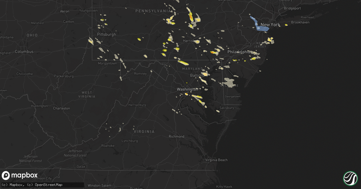
Hail Map in Maryland on June 29, 2019
Get this storm
June 29 map
$229
one time, instant access
Download today. No call, no setup
Keep the $229
Bought the map and want the full workflow? Apply the entire $229 to a subscription within 7 days. None of it is wasted.
Every map, not just this one
This buys you this map. Subscription and you get every map we run, in the markets you choose from a few cities to whole states to nationwide. Plus real-time alerts the moment a storm fires.
Contact data
Name, contact info, occupancy, even credit band for addresses in the footprint. You go from where it hit to who to call.
Become the source they trust
Unlimited branding weather history reports on demand. You already have the documented answer ready for the property owner, and you are the one who showed up with it.
Property data and RoofTrace estimates
Pull up any address you have got, its value and the exact code rules for that jurisdiction, straight from One Click Code. Then RoofTrace estimates the squares, pitch, and roof value, priced the way you price.
Storm reports in Maryland
Maryland
| Date | Description |
|---|---|
| 06/29/20194:45 PM CDT | Mddot gauge. |
| 06/29/20194:40 PM CDT | Trees down in the owings area. |
| 06/29/20194:00 PM CDT | A few tree limbs snapped and fell on power lines in the riverdale area. |
| 06/29/20193:55 PM CDT | A few tree limbs snapped and landed on power lines in the laurel area. |
| 06/29/20193:47 PM CDT | Half a dozen calls for trees down |
| 06/29/20193:45 PM CDT | Half a dozen calls for trees down |
| 06/29/20193:45 PM CDT | Multiple trees down... Roof shingles and siding torn off houses... Damage to river docks near 322 river road. |
| 06/29/20193:40 PM CDT | Tree down on bucks haven lane near bucks haven court. |
| 06/29/20193:37 PM CDT | Tree down on bucks haven lane near bucks haven court. |
| 06/29/20193:33 PM CDT | Large tree down near the intersection of race road and furnace road. |
| 06/29/20193:30 PM CDT | Trees down in the area. Time estimated from radar. |
| 06/29/20193:28 PM CDT | Several trees down along cayots corner road between md 213 and st augustine road. Time estimated from radar. |
| 06/29/20193:18 PM CDT | Tree down on annapolis rock road between hipsley mill road and the montgomery county line. |
| 06/29/20193:12 PM CDT | Several pictures of trees down around damascus... Md. |
| 06/29/20193:10 PM CDT | Several pictures of trees down around damascus... Md. |
| 06/29/20193:02 PM CDT | Social media photo of large tree blown down across blue ball road near wheatley road. More trees reported down in the area. Time estimated from radar. |
| 06/29/20192:52 PM CDT | Tree down on a car in the 3200 block of us-1 conowingo road. |
| 06/29/20192:52 PM CDT | Tree down on us-1 conowingo road near forge hill road... Blocking all lanes. |
| 06/29/20192:51 PM CDT | Thunderstorm outflow resulted in a downed tree and wires on conowingo road. Time estimated from radar. |
| 06/29/20192:40 PM CDT | Trees down near md 402 and central village dr |
| 06/29/20192:39 PM CDT | A local report indicates 1.00 inch wind near 4 N DARES BEACH |
| 06/29/20192:25 PM CDT | Tree down near the intersection of chapel point road and old warehouse road. Tree down in the 9700 block of poorhouse road. |
| 06/29/20192:08 PM CDT | Multiple trees down in the dunkirk area. |
| 06/29/20191:55 PM CDT | Several downed trees and limbs along state highway 310 south of chesapeake city. Time estimated from radar. |
| 06/29/20191:51 PM CDT | Downed trees resulted in property damage on woodstock farm lane. Time estimated from radar. |
| 06/29/20191:23 PM CDT | Branch down in the clinton area. |
| 06/29/20196:40 AM CDT | At 1139 PM EDT, severe thunderstorms were located along a line extending from Fallston to Rosedale, moving east at 35 mph. HAZARD...60 mph wind gusts. SOURCE...Radar indicated. IMPACT...Damaging winds will cause some trees and large branches to fall. This could injure those outdoors, as well as damage homes and vehicles. Roadways may become blocked by downed trees. Localized power outages are possible. Unsecured light objects may become projectiles. Locations impacted include... Middle River, Aberdeen, Havre De Grace, Aberdeen Proving Ground, Back River, Dundalk, Bel Air South, Essex, Bel Air North, Carney, Perry Hall, Rosedale, Rossville, White Marsh, Fallston, Bowleys Quarters, Riverside, Kingsville, Pleasant Hills and Perryman. |
| 06/29/20195:47 AM CDT | At 1047 PM EDT, a severe thunderstorm was located over Westminster, moving east at 35 mph. HAZARD...60 mph wind gusts and quarter size hail. SOURCE...Radar indicated. IMPACT...Damaging winds will cause some trees and large branches to fall. This could injure those outdoors, as well as damage homes and vehicles. Roadways may become blocked by downed trees. Localized power outages are possible. Unsecured light objects may become projectiles. Locations impacted include... Pikesville, Cockeysville, Westminster, Towson, Owings Mills, Reisterstown, Mays Chapel, Timonium, Hampstead, Hampton, Manchester, Lutherville-Timonium, Lutherville, New Windsor, Finksburg, Carrollton, Upperco, Riderwood, Brooklandville and Uniontown. |
| 06/29/20195:25 AM CDT | At 1025 PM EDT, severe thunderstorms were located along a line extending from 6 miles north of Boyds to Round Hill, moving southeast at 30 mph. HAZARD...60 mph wind gusts. SOURCE...Radar indicated. IMPACT...Damaging winds will cause some trees and large branches to fall. This could injure those outdoors, as well as damage homes and vehicles. Roadways may become blocked by downed trees. Localized power outages are possible. Unsecured light objects may become projectiles. Locations impacted include... Germantown, Gaithersburg, Leesburg, South Riding, Damascus, Broadlands, Lansdowne, Lowes Island, Brambleton, Poolesville, Dulles International Airport, Ashburn, Montgomery Village, Sterling, North Potomac, Chantilly, Redland, Countryside, Purcellville and Round Hill. |
| 06/29/20195:18 AM CDT | At 1018 PM EDT, a severe thunderstorm was located 9 miles south of Farmington, or 14 miles north of Kingwood, moving southeast at 35 mph. HAZARD...Wind gusts to 60 mph. SOURCE...Radar. IMPACT...Expect damage to trees and power lines, resulting in some power outages. Locations impacted include... Mountain Lake Park... Oakland... Terra Alta... Bittinger... Loch Lynn Heights... Friendsville... Deer Park... Accident... Markleysburg... Brandonville... Bruceton Mills... Valley Point... |
| 06/29/20193:44 AM CDT | At 843 PM EDT, a severe thunderstorm was located over Saint Charles, or near Waldorf, moving east at 25 mph. HAZARD...60 mph wind gusts. SOURCE...Radar indicated. IMPACT...Damaging winds will cause some trees and large branches to fall. This could injure those outdoors, as well as damage homes and vehicles. Roadways may become blocked by downed trees. Localized power outages are possible. Unsecured light objects may become projectiles. Locations impacted include... Waldorf, La Plata, Saint Charles, Accokeek, Bryans Road, Hughesville, Charlotte Hall, Aquasco, Bryantown, Pomfret, Dentsville and White Plains. |
| 06/29/20193:33 AM CDT | At 833 PM EDT, a severe thunderstorm was located near Hallowing Point, moving east at 25 mph. HAZARD...60 mph wind gusts. SOURCE...Radar indicated. IMPACT...Damaging winds will cause some trees and large branches to fall. This could injure those outdoors, as well as damage homes and vehicles. Roadways may become blocked by downed trees. Localized power outages are possible. Unsecured light objects may become projectiles. Locations impacted include... Chesapeake Ranch Estates, Prince Frederick, Sheridan Point, Flag Harbor, Calvert Cliffs, Lusby, Saint Leonard, Hughesville, Long Beach, Aquasco, Calvert Beach, Benedict, Eagle Harbor, Barstow and Port Republic. |
| 06/29/20193:19 AM CDT | At 819 PM EDT, severe thunderstorms were located along a line extending from 6 miles southwest of Clearville to near Lake Gordon, moving southeast at 30 mph. HAZARD...60 mph wind gusts. SOURCE...Radar indicated. IMPACT...Damaging winds will cause some trees and large branches to fall. This could injure those outdoors, as well as damage homes and vehicles. Roadways may become blocked by downed trees. Localized power outages are possible. Unsecured light objects may become projectiles. Locations impacted include... Hancock, Paw Paw, Greenwood, Berkeley Springs, Great Cacapon, Flintstone, Pecktonville, Big Pool, Little Orleans, Johnsons Mill, Valley View, Spohrs Crossroads, Fishers Bridge, Pumpkin Center, Oakland, Rock Gap, Smith Crossroads, Unger, New Hope and Shady Grove. |
| 06/29/20192:59 AM CDT | At 759 PM EDT, a severe thunderstorm was located near Marlton, or 7 miles southeast of Clinton, moving east at 25 mph. HAZARD...60 mph wind gusts. SOURCE...Radar indicated. IMPACT...Damaging winds will cause some trees and large branches to fall. This could injure those outdoors, as well as damage homes and vehicles. Roadways may become blocked by downed trees. Localized power outages are possible. Unsecured light objects may become projectiles. Locations impacted include... Clinton, Fort Washington, Chesapeake Beach, Prince Frederick, Breezy Point, Andrews Air Force Base, Camp Springs, Oxon Hill, Rosaryville, Friendly, Marlton, Temple Hills, Marlow Heights, Dunkirk, Accokeek, Brandywine, Huntingtown, Owings, Baden and Aquasco. |
| 06/29/201912:11 AM CDT | At 510 PM EDT, a severe thunderstorm was located near Quantico, moving southeast at 20 mph. HAZARD...60 mph wind gusts and quarter size hail. SOURCE...Radar indicated. IMPACT...Damaging winds will cause some trees and large branches to fall. This could injure those outdoors, as well as damage homes and vehicles. Roadways may become blocked by downed trees. Localized power outages are possible. Unsecured light objects may become projectiles. Locations impacted include... Waldorf, La Plata, Dahlgren, Port Tobacco River, Popes Creek, Saint Charles, Wicomico, Bryans Road, Hughesville, Potomac Heights, Bryantown, Pomfret, Port Tobacco Village, Ironsides, Bel Alton, Pisgah, Faulkner, Berthaville, Marbury and Dentsville. |
| 06/29/201912:05 AM CDT | At 505 PM EDT, a severe thunderstorm was located over Kettering, or near Bowie, moving southeast at 25 mph. HAZARD...60 mph wind gusts and quarter size hail. SOURCE...Radar indicated. IMPACT...Damaging winds will cause some trees and large branches to fall. This could injure those outdoors, as well as damage homes and vehicles. Roadways may become blocked by downed trees. Localized power outages are possible. Unsecured light objects may become projectiles. Locations impacted include... Bowie, Annapolis, Crofton, Forestville, Largo, Mayo, Shady Side, Chesapeake Beach, Deale, Naval Academy, Upper Marlboro, Severn River, South River, Breezy Point, Rhode River, Fedex Field, Odenton, Arnold, Parole and Kettering. |
| 06/28/201911:58 PM CDT | At 457 PM EDT, a severe thunderstorm was located near Gibson Island, moving southeast at 30 mph. HAZARD...60 mph wind gusts and half dollar size hail. SOURCE...Radar indicated. IMPACT...Minor damage to vehicles is possible. Wind damage to roofs, siding, trees, and power lines is possible. Locations impacted include... Easton, Centerville, Centreville, Rock Hall, Queen Anne, Grasonville, Starr, Stevensville, Skipton, Copperville, Chester, Overton, Wye Mills, Cordova, Carville, Hope, Queenstown, Stevensville South and Dominion. |
| 06/28/201911:52 PM CDT | At 452 PM EDT, a severe thunderstorm was located over Hazlettville, or near Dover, moving east at 15 mph. HAZARD...60 mph wind gusts and quarter size hail. SOURCE...Radar indicated. IMPACT...Minor damage to vehicles is possible. Wind damage to roofs, siding, trees, and power lines is possible. Locations impacted include... Dover, Milford, Camden, Bowers, Woodside, Viola, Rising Sun-Lebanon, Rising Sun, Hazlettville, Dover Base Housing, Big Stone Beach, Sandtown, Wyoming, Felton, Frederica, Magnolia, Marydel, Rodney Village, Kent Acres and Riverview. |
| 06/28/201911:45 PM CDT | At 445 PM EDT, a severe thunderstorm was located near Dale City, moving southeast at 20 mph. HAZARD...60 mph wind gusts and quarter size hail. SOURCE...Radar indicated. IMPACT...Damaging winds will cause some trees and large branches to fall. This could injure those outdoors, as well as damage homes and vehicles. Roadways may become blocked by downed trees. Localized power outages are possible. Unsecured light objects may become projectiles. Locations impacted include... Dale City, Fort Belvoir, Woodbridge, Quantico, Lake Ridge, Linton Hall, Montclair, Lorton, Triangle, Dumfries, Manassas, Cherry Hill, Independent Hill, Mason Neck, Nokesville, Occoquan and Aden. |
| 06/28/201911:43 PM CDT | At 443 PM EDT, a severe thunderstorm was located near Berkeley Springs, or 9 miles south of Hancock, moving southeast at 25 mph. HAZARD...60 mph wind gusts. SOURCE...Radar indicated. IMPACT...Damaging winds will cause some trees and large branches to fall. This could injure those outdoors, as well as damage homes and vehicles. Roadways may become blocked by downed trees. Localized power outages are possible. Unsecured light objects may become projectiles. Locations impacted include... Martinsburg, Inwood, Berkeley, Falling Waters, Hedgesville, Winebrenners Cross, Tomahawk, Johnsontown, Shanghai, Vanville, Arden, Jones Springs and Martinsburg Airport. |
| 06/28/201911:38 PM CDT | At 437 PM EDT, severe thunderstorms were located along a line extending from Port Penn to Warwick, moving southeast at 30 mph. HAZARD...60 mph wind gusts and quarter size hail. SOURCE...Radar indicated. IMPACT...Minor damage to vehicles is possible. Wind damage to roofs, siding, trees, and power lines is possible. Locations impacted include... Dover, Middletown, Smyrna, Camden, Clayton, Delaware City, Cheswold, Cecilton, Hartly, Warwick, Bohemias Mills, Hazlettville, Port Penn, Delaney Corner, Dover Base Housing, Dover Speedway, Saint Georges, Sassafras, Mount Pleasant and Green Spring. |
| 06/28/201911:34 PM CDT | At 434 PM EDT, a severe thunderstorm was located over Fort Meade, or over Severn, moving southeast at 20 mph. HAZARD...60 mph wind gusts. SOURCE...Radar indicated. IMPACT...Damaging winds will cause some trees and large branches to fall. This could injure those outdoors, as well as damage homes and vehicles. Roadways may become blocked by downed trees. Localized power outages are possible. Unsecured light objects may become projectiles. Locations impacted include... Columbia, Severn, Annapolis, Crofton, Elkridge, Riviera Beach, Mayo, Naval Academy, Baltimore-Washington Airport, Severn River, South River, Gibson Island, Bodkin Point, Sillery Bay, Pinehurst, Glen Burnie, Ellicott City, Severna Park, Odenton and Laurel. |
| 06/28/201911:24 PM CDT | At 424 PM EDT, a severe thunderstorm was located 7 miles southwest of Sykesville, or 8 miles east of Damascus, moving east at 20 mph. HAZARD...60 mph wind gusts. SOURCE...Radar indicated. IMPACT...Damaging winds will cause some trees and large branches to fall. This could injure those outdoors, as well as damage homes and vehicles. Roadways may become blocked by downed trees. Localized power outages are possible. Unsecured light objects may become projectiles. Locations impacted include... Columbia, Ellicott City, Catonsville, Woodlawn, Randallstown, Milford Mill, Savage-guilford, Scaggsville, Ilchester, Burtonsville, Savage, Fulton, Highland, Clarksville, West Friendship, Dayton, Woodstock, Granite, Roxbury Mills and Glenelg. |
| 06/28/201911:19 PM CDT | At 419 PM EDT, a severe thunderstorm was located over Severn River, moving east at 20 mph. HAZARD...60 mph wind gusts. SOURCE...Radar indicated. IMPACT...Damaging winds will cause some trees and large branches to fall. This could injure those outdoors, as well as damage homes and vehicles. Roadways may become blocked by downed trees. Localized power outages are possible. Unsecured light objects may become projectiles. Locations impacted include... Annapolis, Mayo, Naval Academy, Severn River, South River, Severna Park, Arnold, Lake Shore, Parole, Edgewater, Cape St. Claire, Highland Beach, Hillsmere Shores, Sherwood Forest, Belvedere Heights, Navy-Marine Corps Stadium, Eastport and Bay Ridge. |
| 06/28/201911:14 PM CDT | At 414 PM EDT, a severe thunderstorm was located over Chestertown, or 10 miles north of Centerville, moving southeast at 25 mph. HAZARD...60 mph wind gusts and quarter size hail. SOURCE...Radar indicated. IMPACT...Minor damage to vehicles is possible. Wind damage to roofs, siding, trees, and power lines is possible. Locations impacted include... Chestertown, Church Hill, Sudlersville, Starkey Corner, Old Town, Langford, Templeville, Barclay and Kingstown. |
| 06/28/201911:13 PM CDT | At 413 PM EDT, a severe thunderstorm was located over Woodlawn, or near Pikesville, moving east at 20 mph. HAZARD...60 mph wind gusts. SOURCE...Radar indicated. IMPACT...Damaging winds will cause some trees and large branches to fall. This could injure those outdoors, as well as damage homes and vehicles. Roadways may become blocked by downed trees. Localized power outages are possible. Unsecured light objects may become projectiles. Locations impacted include... Baltimore, Pikesville, Middle River, Riviera Beach, Baltimore-Washington Airport, North Point State Park, Sparrows Point, Back River, Millers Island, Glen Burnie, Ellicott City, Dundalk, Towson, Catonsville, Essex, Woodlawn, Randallstown, Parkville, Milford Mill and Perry Hall. |
| 06/28/201911:11 PM CDT | At 410 PM EDT, a severe thunderstorm was located over Inglesmith, or 11 miles west of Hancock, moving southeast at 25 mph. HAZARD...60 mph wind gusts and quarter size hail. SOURCE...Radar indicated. IMPACT...Damaging winds will cause some trees and large branches to fall. This could injure those outdoors, as well as damage homes and vehicles. Roadways may become blocked by downed trees. Localized power outages are possible. Unsecured light objects may become projectiles. Locations impacted include... Hancock, Berkeley Springs, Great Cacapon, Pecktonville, Big Pool, Little Orleans, Johnsons Mill, Cherry Run, Lineburg, Valley View, Spohrs Crossroads, Spruce Pine Hollow, Rock Gap, Stotlers Crossroads, Highland Ridge, Forest Park, Bellegrove, Smith Crossroads, Berryville and New Hope. |
| 06/28/201911:08 PM CDT | At 408 PM EDT, a severe thunderstorm was located over Damascus, moving southeast at 20 mph. HAZARD...60 mph wind gusts and quarter size hail. SOURCE...Radar indicated. IMPACT...Damaging winds will cause some trees and large branches to fall. This could injure those outdoors, as well as damage homes and vehicles. Roadways may become blocked by downed trees. Localized power outages are possible. Unsecured light objects may become projectiles. Locations impacted include... Germantown, Rockville, Gaithersburg, Olney, Damascus, Aspen Hill, Montgomery Village, North Potomac, Redland, Rossmoor, Scaggsville, Cloverly, Clarksburg, Burtonsville, Derwood, Fulton, Spencerville, Highland, Washington Grove and Laytonsville. |
| 06/28/201911:05 PM CDT | At 405 PM EDT, a severe thunderstorm was located over Hybla Valley, or over Groveton, moving southeast at 15 mph. HAZARD...70 mph wind gusts and quarter size hail. SOURCE...Radar indicated. IMPACT...Damaging winds will cause some trees and large branches to fall. This could injure those outdoors, as well as damage homes and vehicles. Roadways may become blocked by downed trees. Localized power outages are possible. Unsecured light objects may become projectiles. Locations impacted include... Alexandria, Waldorf, Annandale, Clinton, Springfield, Fort Washington, Fort Hunt, Groveton, Huntington, La Plata, Fort Belvoir, National Harbor, Lincolnia, Camp Springs, Lorton, Franconia, Oxon Hill, Hybla Valley, Newington and Rosaryville. |
| 06/28/201910:59 PM CDT | At 359 PM EDT, severe thunderstorms were located along a line extending from near Kennett Square to Glen Westover to Farmington, moving southeast at 35 mph. HAZARD...70 mph wind gusts and quarter size hail. SOURCE...Radar indicated. IMPACT...Minor damage to vehicles is possible. Expect considerable tree damage. Wind damage is also likely to mobile homes, roofs, and outbuildings. Locations impacted include... Wilmington, Newark, Middletown, Elkton, Calvert, Chester, Pennsville, Carneys Point, Elsmere, Kennett Square, New Castle, Penns Grove, Salem, Oxford, North East, Woodstown, Alloway, West Grove, Rising Sun and Quinton. |
| 06/28/201910:49 PM CDT | At 349 PM EDT, a severe thunderstorm was located 8 miles northeast of Lake Gordon, moving southeast at 30 mph. HAZARD...60 mph wind gusts and quarter size hail. SOURCE...Radar indicated. IMPACT...Hail damage to vehicles is expected. Expect wind damage to trees, roofs, and siding. Locations impacted include... Warfordsburg, Barnes Gap, Inglesmith, Lake Gordon and Rainsburg. This includes Interstate 70 near mile marker 162...and from milemarkers 167 to 170. |
| 06/28/201910:48 PM CDT | At 348 PM EDT, severe thunderstorms were located along a line extending from near Delta to Bel Air North, moving east at 30 mph. HAZARD...60 mph wind gusts. SOURCE...Radar indicated. IMPACT...Damaging winds will cause some trees and large branches to fall. This could injure those outdoors, as well as damage homes and vehicles. Roadways may become blocked by downed trees. Localized power outages are possible. Unsecured light objects may become projectiles. Locations impacted include... Aberdeen, Havre De Grace, Aberdeen Proving Ground, Bel Air South, Bel Air North, Fallston, Riverside, Pleasant Hills, Perryman, Edgewood, Darlington, Benson, Churchville, Carsins, Scarboro, Forest Hill, Bynum, Harford Furnace, Abingdon and Hickory. |
| 06/28/201910:47 PM CDT | Golfball size hail with damage to vehicles. |
| 06/28/201910:33 PM CDT | At 333 PM EDT, a severe thunderstorm was located 7 miles southeast of Taylors Island, moving southeast at 20 mph. HAZARD...60 mph wind gusts. SOURCE...Radar indicated. IMPACT...Expect damage to trees and powerlines. Locations impacted include... Church Creek, Madison, Woolford, Andrews, Elliott, Crocheron, Bucktown and Wingate. |
| 06/28/201910:27 PM CDT | At 326 PM EDT, severe thunderstorms were located along a line extending from near Gap to near Safe Harbor to near Stewartstown, moving east at 25 mph. HAZARD...Golf ball size hail and 70 mph wind gusts. SOURCE...Radar indicated. IMPACT...People and animals outdoors will be injured. Expect hail damage to roofs, siding, windows, and vehicles. Expect considerable tree damage. Wind damage is also likely to mobile homes, roofs, and outbuildings. Locations impacted include... Havre De Grace, Calvert, Kennett Square, Oxford, Parkesburg, North East, West Grove, Rising Sun, Homeville, Glen Roy, Zion, Blake, Cochranville, West Nottingham, Octoraro, Mount Vernon, Fair Hill, Glen Westover, Bay View and Lombard. |
| 06/28/201910:27 PM CDT | At 327 PM EDT, a severe thunderstorm was located near Prince Frederick, moving southeast at 20 mph. HAZARD...60 mph wind gusts and quarter size hail. SOURCE...Radar indicated. IMPACT...Damaging winds will cause some trees and large branches to fall. This could injure those outdoors, as well as damage homes and vehicles. Roadways may become blocked by downed trees. Localized power outages are possible. Unsecured light objects may become projectiles. Locations impacted include... Chesapeake Ranch Estates, Prince Frederick, Breezy Point, Flag Harbor, Calvert Cliffs, Lusby, Saint Leonard, Huntingtown, Long Beach, Calvert Beach, Port Republic and Dares Beach. |
| 06/28/201910:15 PM CDT | At 315 PM EDT, severe thunderstorms were located along a line extending from Rothsville to near Strasburg to near Brogue, moving east at 20 mph. HAZARD...60 mph wind gusts and quarter size hail. SOURCE...Radar indicated. IMPACT...Hail damage to vehicles is expected. Expect wind damage to trees, roofs, and siding. Locations impacted include... Lancaster, Ephrata, Columbia, Lititz, Millersville, Willow Street, Mount Joy, Red Lion, New Holland, Manheim, East Petersburg, Dallastown, Akron, Leola, Stonybrook-Wilshire, Paradise, Salunga-Landisville, Denver, Reamstown and Rothsville.This includes The Pennsylvania Turnpike from mile markers 275 to 295. |
| 06/28/20199:49 PM CDT | Over a dozen trees down along savage river road. |
| 06/28/20199:47 PM CDT | At 246 PM EDT, a severe thunderstorm was located over Cayots, or near Elkton, and moving east at 5 mph. HAZARD...60 mph wind gusts and quarter size hail. SOURCE...Radar indicated. IMPACT...Minor damage to vehicles is possible. Wind damage to roofs, siding, trees, and power lines is possible. Locations impacted include... Middletown, Warwick, Mount Pleasant, Cayots, Hollywood Beach, Bohemias Mills and Chesapeake City. |
| 06/28/20199:37 PM CDT | At 237 PM EDT, a severe thunderstorm was located over Rosaryville, or near Clinton, moving southeast at 20 mph. HAZARD...60 mph wind gusts and quarter size hail. SOURCE...Radar indicated. IMPACT...Damaging winds will cause some trees and large branches to fall. This could injure those outdoors, as well as damage homes and vehicles. Roadways may become blocked by downed trees. Localized power outages are possible. Unsecured light objects may become projectiles. Locations impacted include... Clinton, Chesapeake Beach, Prince Frederick, Breezy Point, Andrews Air Force Base, Rosaryville, Marlton, Dunkirk, Accokeek, Brandywine, Huntingtown, Owings, Baden, Aquasco, Calvert Beach, Friendship, Lower Marlboro, Port Republic, Sunderland and Cheltenham. |
| 06/28/20199:36 PM CDT | Large tree limbs down in the taneytown area. |
| 06/28/20199:28 PM CDT | At 228 PM EDT, a severe thunderstorm was located over Fredericksburg, moving southeast at 20 mph. HAZARD...60 mph wind gusts and quarter size hail. SOURCE...Radar indicated. IMPACT...Damaging winds will cause some trees and large branches to fall. This could injure those outdoors, as well as damage homes and vehicles. Roadways may become blocked by downed trees. Localized power outages are possible. Unsecured light objects may become projectiles. Locations impacted include... Stafford, Fredericksburg, King George, Fairview Beach, Aquia Creek, Massaponax, Spotsylvania, Falmouth, Passapatanzy, Stones Corner, Ramoth, Thornburg, White Oak, Sealston, Jersey, Dogue, Leeland, Rollins Fork, Arkendale and Spring Valley. |
| 06/28/20199:26 PM CDT | At 225 PM EDT, a severe thunderstorm was located over Fort Loudon, moving southeast at 35 mph. HAZARD...60 mph wind gusts and quarter size hail. SOURCE...Radar indicated. IMPACT...Hail damage to vehicles is expected. Expect wind damage to trees, roofs, and siding. Locations impacted include... Waynesboro, Greencastle, Wayne Heights, Mercersburg, McConnellsburg, Rouzerville, Marion, Fort Loudon, Big Cove Tannery, Claylick, State Line, Quincy, Williamson and Upton.This includes Interstate 81 from mile markers 0 to 9. |
| 06/28/20199:20 PM CDT | At 219 PM EDT, a severe thunderstorm was located near Dahlgren, moving southeast at 15 mph. HAZARD...60 mph wind gusts and quarter size hail. SOURCE...Radar indicated. IMPACT...Damaging winds will cause some trees and large branches to fall. This could injure those outdoors, as well as damage homes and vehicles. Roadways may become blocked by downed trees. Localized power outages are possible. Unsecured light objects may become projectiles. Locations impacted include... King George, Leonardtown, Dahlgren, Fairview Beach, Saint Clements Bay, Popes Creek, Wicomico, Cobb Island, Rock Point, Bushwood, Clements, Issue, Tompkinsville, Weedonville, Abell, Chaptico, Ninde, Bel Alton, Swan Point and Avenue. |
| 06/28/20199:19 PM CDT | At 219 PM EDT, a severe thunderstorm was located near Pine Grove Furnace, moving southeast at 45 mph. HAZARD...60 mph wind gusts and half dollar size hail. SOURCE...Radar indicated. IMPACT...Hail damage to vehicles is expected. Expect wind damage to trees, roofs, and siding. Locations impacted include... Hanover, Gettysburg, Parkville, Hampton, Codorus, McSherrystown, Lake Meade, Spring Grove, Glen Rock, Pennville, Bonneauville, New Oxford, East Berlin, Lake Heritage, Cashtown, Aspers, Orrtanna, Pine Grove Furnace, York Airport and Biglerville.This includes Interstate 83 from mile markers 6 to 7. |
| 06/28/20198:40 PM CDT | Tree down on mapleville rd. South of national pike. |
| 06/28/20198:26 PM CDT | At 126 PM EDT, a severe thunderstorm was located near Hollywood Beach, or 8 miles east of Aberdeen Proving Ground, moving southeast at 15 mph. HAZARD...60 mph wind gusts and quarter size hail. SOURCE...Radar indicated. IMPACT...Minor damage to vehicles is possible. Wind damage to roofs, siding, trees, and power lines is possible. Locations impacted include... Cecilton, Warwick, Cayots, Crumpton, Bohemias Mills, Kennedyville, Sassafras and Galena. |
| 06/28/20198:05 PM CDT | Tree down near intersection of e. Industrial blvd. And winston st. |
| 06/28/20197:49 PM CDT | Trees down in the prince frederick area. |
| 06/28/20197:32 PM CDT | Quarter size hail at chesapeake beach |
| 06/28/20197:30 PM CDT | Numerous trees down in the north beach area. |
| 06/28/20197:29 PM CDT | Quarter size hail at chesapeake beach |
| 06/28/20197:27 PM CDT | A local report indicates 1.00 inch wind near 1 SSE MOUNT HARMONY |
| 06/28/20197:26 PM CDT | A local report indicates 1.00 inch wind near 1 SSE MOUNT HARMONY |
| 06/28/20197:23 PM CDT | Multiple trees down in the owings area. |
| 06/28/20197:15 PM CDT | Multiple trees down in the dunkirk area. |
All States Impacted by Hail Map on June 29, 2019
- Minnesota
- North Dakota
- New Jersey
- Oklahoma
- Texas
- Delaware
- Maryland
- Pennsylvania
- West Virginia
- Montana
- South Dakota
- Wisconsin
- New York
- Rhode Island
- Massachusetts
- Nebraska
- Illinois
- Virginia
- Ohio
- Wyoming
- Alabama
- Connecticut
- Florida
- Colorado
- Arkansas
- New Hampshire
- Georgia
- Mississippi
- Indiana
- Iowa
- Oregon
- Maine
- Kentucky
- Tennessee
- Louisiana
Cities Impacted by Hail Map on June 29, 2019
- Saint Vincent, MN
- Pembina, ND
- Lancaster, MN
- Sicklerville, NJ
- Blackwood, NJ
- Stringtown, OK
- Antlers, OK
- Daisy, OK
- Clayton, OK
- Lane, OK
- Atoka, OK
- Wolfe City, TX
- Dover, DE
- Middle River, MD
- Harmony, PA
- Fombell, PA
- Pasadena, MD
- Felton, MN
- Ponemah, MN
- Blackduck, MN
- Kelliher, MN
- Teague, TX
- Buffalo, TX
- Fairfield, TX
- Oakwood, TX
- Cummings, ND
- Mayville, ND
- Hillsboro, ND
- Portland, ND
- Richardton, ND
- Renovo, PA
- Beech Creek, PA
- Philadelphia, PA
- Waldorf, MD
- Grapeland, TX
- Houston, TX
- Pearland, TX
- Pennington, MN
- Deer River, MN
- Tenstrike, MN
- Marcell, MN
- Squaw Lake, MN
- Spring Lake, MN
- Max, MN
- Grand Rapids, MN
- Bemidji, MN
- Northome, MN
- Puposky, MN
- Talmoon, MN
- Bena, MN
- Bigfork, MN
- Hines, MN
- Cohasset, MN
- Bethany, WV
- Wellsburg, WV
- Belcamp, MD
- Bel Air, MD
- Aberdeen, MD
- Abingdon, MD
- Midlothian, TX
- Baytown, TX
- Plentywood, MT
- Webster, ND
- Coatesville, PA
- Parkesburg, PA
- Cammal, PA
- Elizabethville, PA
- Dalmatia, PA
- Mount Pleasant Mills, PA
- Port Trevorton, PA
- Liverpool, PA
- Martin, SD
- Allen, SD
- Decatur, TX
- Christiana, PA
- Strasburg, PA
- Ronks, PA
- Atglen, PA
- Paradise, PA
- Cochranville, PA
- Quarryville, PA
- Bruce, WI
- Weyerhaeuser, WI
- Conklin, NY
- Binghamton, NY
- Susquehanna, PA
- Brackney, PA
- Kirkwood, NY
- Hallstead, PA
- Windsor, NY
- Great Bend, PA
- Maddock, ND
- Lefor, ND
- Gunter, TX
- Howe, TX
- Sherman, TX
- Pawtucket, RI
- Johnston, RI
- Central Falls, RI
- Cumberland, RI
- North Attleboro, MA
- North Providence, RI
- Smithfield, RI
- Seekonk, MA
- Attleboro, MA
- Rehoboth, MA
- Providence, RI
- Lincoln, RI
- Snow, OK
- Winter, WI
- Ellsworth, NE
- Smyrna, DE
- Townsend, DE
- New Columbia, PA
- Watchung, NJ
- Plainfield, NJ
- Vincentown, NJ
- Manchester Township, NJ
- Glyndon, MN
- Webster, WI
- Salix, PA
- South Fork, PA
- Elton, PA
- Johnstown, PA
- Windber, PA
- Malden, IL
- Arlington, IL
- Spring Valley, IL
- Princeton, IL
- Cherry, IL
- Potter, NE
- Dalton, NE
- Gurley, NE
- Woodford, VA
- Fredericksburg, VA
- Crosby, ND
- Alamo, ND
- Crary, ND
- Starkweather, ND
- Devils Lake, ND
- Santa Fe, TX
- Alvin, TX
- Lansford, ND
- Maxbass, ND
- Redlake, MN
- Redby, MN
- Browns Mills, NJ
- Pemberton, NJ
- Nicholson, PA
- Kingsley, PA
- Factoryville, PA
- Fleetville, PA
- Dalton, PA
- Hop Bottom, PA
- Bellefonte, PA
- Centre Hall, PA
- State College, PA
- Kenmare, ND
- Ulster, PA
- Hammondsville, OH
- Carrollton, OH
- Kensington, OH
- Mechanicstown, OH
- Salineville, OH
- Victoria, TX
- Middle River, MN
- Gordon, NE
- Middletown, RI
- Brainerd, MN
- Lock Haven, PA
- Doylesburg, PA
- Blairs Mills, PA
- East Waterford, PA
- Blain, PA
- Mcville, ND
- Pekin, ND
- Massapequa Park, NY
- Farmingdale, NY
- Massapequa, NY
- Amityville, NY
- Lindenhurst, NY
- Copiague, NY
- Reading, PA
- Allenwood, PA
- Asbury Park, NJ
- West Long Branch, NJ
- Oakhurst, NJ
- Eatontown, NJ
- Exeland, WI
- Ojibwa, WI
- Radisson, WI
- Harrison, NE
- Lusk, WY
- Mercersburg, PA
- Towner, ND
- Rugby, ND
- Mott, ND
- Streetman, TX
- Goodridge, MN
- Corrigan, TX
- Diboll, TX
- Glenburn, ND
- Cooperstown, ND
- Finley, ND
- Hope, ND
- Waynesburg, OH
- Danville, IL
- Hoopeston, IL
- Rossville, IL
- Alvin, IL
- Bismarck, IL
- North Bend, PA
- Earleville, MD
- North East, MD
- Emory, TX
- La Grange, TX
- Giddings, TX
- Mylo, ND
- Flasher, ND
- Carson, ND
- Pingree, ND
- Danbury, WI
- Gordon, WI
- Carpenter, WY
- Watson, OK
- Powell, TX
- Kerens, TX
- Rice, TX
- Upperstrasburg, PA
- Fort Loudon, PA
- Bay City, TX
- Randolph, AL
- Penelope, TX
- Hubbard, TX
- Mertens, TX
- Frost, TX
- Malone, TX
- Laporte, MN
- Caney, OK
- Dallas, TX
- Hebron, ND
- New Leipzig, ND
- Canonsburg, PA
- Hainesport, NJ
- Mount Holly, NJ
- Lumberton, NJ
- Celeste, TX
- Farmersville, TX
- Milroy, PA
- Remer, MN
- Henning, IL
- Alexandria, VA
- Lewisburg, PA
- Canton, TX
- Bandera, TX
- Kutztown, PA
- Mertztown, PA
- Celina, TX
- Isle, MN
- Friendsville, PA
- Montrose, PA
- Ennis, TX
- Barry, TX
- Caddo Mills, TX
- Backus, MN
- Kilgore, NE
- Danville, PA
- Shrewsbury, NJ
- Long Branch, NJ
- Oceanport, NJ
- Red Bank, NJ
- Little Silver, NJ
- Deal, NJ
- Fort Monmouth, NJ
- Foster, RI
- Coventry, RI
- Greene, RI
- Saint Thomas, PA
- New Canaan, CT
- New Port Richey, FL
- Moundsville, WV
- Elgin, ND
- Colts Neck, NJ
- Monmouth Beach, NJ
- Rumson, NJ
- Bessemer, AL
- Oakman, AL
- Kemp, TX
- La Moille, IL
- Valley Stream, NY
- Lynbrook, NY
- West Hempstead, NY
- Malverne, NY
- Rockville Centre, NY
- Fleetwood, PA
- Shoemakersville, PA
- Willow City, ND
- Oxford, PA
- Elkton, MD
- Nottingham, PA
- Rising Sun, MD
- Warwick, MD
- Middletown, DE
- Chesapeake City, MD
- Winfield, PA
- Selinsgrove, PA
- Birchwood, WI
- Thief River Falls, MN
- Owego, NY
- Nichols, NY
- Jemison, AL
- Maplesville, AL
- Lawley, AL
- Brigantine, NJ
- Bottineau, ND
- Newburyport, MA
- Salisbury, MA
- Mifflintown, PA
- Atlanta, TX
- Cumby, TX
- Onarga, IL
- Gilman, IL
- Keller, TX
- Zahl, ND
- Grenora, ND
- Malvern, PA
- Monroeville, NJ
- Liverpool, TX
- Kearneysville, WV
- Kramer, ND
- Galeton, PA
- Nanticoke, MD
- Grampian, PA
- Freehold, NJ
- Jackson, NJ
- Curtis Bay, MD
- Newburg, ND
- Upham, ND
- Strasburg, CO
- Byers, CO
- Fort Washington, MD
- Shamokin, PA
- Sunbury, PA
- Paxinos, PA
- Courtenay, ND
- Spraggs, PA
- Waynesburg, PA
- Palestine, TX
- Trinity, TX
- Carr, CO
- Aliquippa, PA
- Taneytown, MD
- Keymar, MD
- Emily, MN
- Arley, AL
- Jasper, AL
- Gonvick, MN
- Hummelstown, PA
- Middletown, PA
- Harrisburg, PA
- Hershey, PA
- Elizabethtown, PA
- Clearbrook, MN
- Shermans Dale, PA
- New Bloomfield, PA
- Elliottsburg, PA
- Landisburg, PA
- Upper Marlboro, MD
- Bowie, MD
- Davidsonville, MD
- King George, VA
- Colbert, OK
- Hendrix, OK
- Calera, OK
- Durant, OK
- Huntsville, TX
- Knox, ND
- Leeds, ND
- Wolford, ND
- York, ND
- Spring Mills, PA
- Brooklyn, MD
- Greenville, TX
- Harrisburg, NE
- Palmyra, PA
- Montgomery, PA
- Ulysses, PA
- De Queen, AR
- Danforth, IL
- Kempton, IL
- Piper City, IL
- Merriman, NE
- Cody, NE
- Dayville, CT
- Danielson, CT
- Purdon, TX
- Dawson, TX
- Woonsocket, RI
- Sheyenne, ND
- Carrington, ND
- Lyme, NH
- East Rochester, OH
- Minerva, OH
- Paxton, IL
- Woodstown, NJ
- Swedesboro, NJ
- Mullica Hill, NJ
- Williamsport, MD
- Nashoba, OK
- Matagorda, TX
- Prince Frederick, MD
- Port Penn, DE
- New Castle, DE
- Longville, MN
- Marsland, NE
- Felton, DE
- Milford, DE
- Harrington, DE
- Frederica, DE
- New Rockford, ND
- Grygla, MN
- Cook, MN
- Mora, MN
- Rolette, ND
- Hawkinsville, GA
- Floodwood, MN
- Wright, MN
- Pine River, MN
- New Auburn, WI
- Chetek, WI
- Bokchito, OK
- Portal, ND
- Columbus, ND
- Noonan, ND
- Emmitsburg, MD
- Union Bridge, MD
- Westminster, MD
- Fessenden, ND
- Lititz, PA
- Valentine, NE
- Glady, WV
- Bowden, WV
- Venus, TX
- Lakota, ND
- Staten Island, NY
- Newfolden, MN
- Strandquist, MN
- Wimbledon, ND
- Tremont, MS
- Almont, ND
- Glen Ullin, ND
- Loganton, PA
- Mill Hall, PA
- Cohasset, MA
- Hull, MA
- Scituate, MA
- Morristown, IN
- Allentown, PA
- Lockesburg, AR
- Mizpah, MN
- Solway, MN
- Wirt, MN
- Bovey, MN
- Cass Lake, MN
- Jewett, TX
- Ganado, TX
- Rice Lake, WI
- Fairview, WV
- Wylie, TX
- Kerrville, TX
- Shevlin, MN
- Davenport, IA
- Walcott, IA
- Beulah, ND
- Dellroy, OH
- Brogue, PA
- Felton, PA
- Roseland, VA
- Tyro, VA
- Burnet, TX
- Jacobson, MN
- Lake Nebagamon, WI
- South Range, WI
- Poplar, WI
- Crookston, NE
- Amity, PA
- Clarksville, PA
- Prosperity, PA
- Jefferson, PA
- Washington, PA
- Marianna, PA
- Beach Haven, NJ
- Pasadena, TX
- Trego, WI
- Spooner, WI
- Dauphin, PA
- Halifax, PA
- Brownsville, PA
- East Millsboro, PA
- La Belle, PA
- Denbo, PA
- Woodway, TX
- Waco, TX
- Crawford, TX
- McGregor, TX
- Magnolia, DE
- Van Alstyne, TX
- Couderay, WI
- Hayward, WI
- Parsons, WV
- Stephen, MN
- Siren, WI
- Annawan, IL
- Pequot Lakes, MN
- Dwight, IL
- Locust Grove, OK
- Chouteau, OK
- Neptune, NJ
- Farmingdale, NJ
- Stevens, PA
- Newmanstown, PA
- Ephrata, PA
- Denver, PA
- Sisters, OR
- Tuthill, SD
- Shippensburg, PA
- Biglerville, PA
- Crosslake, MN
- La Porte, TX
- Seabrook, TX
- Lovelady, TX
- Springbrook, WI
- Gatzke, MN
- New Milford, PA
- Scio, OH
- Downingtown, PA
- Elverson, PA
- Morgantown, PA
- Glenmoore, PA
- Narvon, PA
- Honey Brook, PA
- Strathcona, MN
- Leonard, MN
- Brookston, MN
- Eustace, TX
- Bisbee, ND
- Fergus Falls, MN
- Perrysville, IN
- Georgetown, IL
- Cayuga, IN
- Justin, TX
- Haslet, TX
- Cullom, IL
- Callery, PA
- Evans City, PA
- Mars, PA
- Maud, TX
- Hooks, TX
- Cochran, GA
- Elm Mott, TX
- West, TX
- Clearville, PA
- Binford, ND
- Sutton, ND
- Glenfield, ND
- Cissna Park, IL
- Covington, IN
- Potomac, IL
- Rankin, IL
- Wellington, IL
- Williamsport, IN
- State Line, IN
- Lewisville, OH
- Summerfield, OH
- Bruceton Mills, WV
- Freeport, TX
- Morgantown, WV
- Dilliner, PA
- Maidsville, WV
- Mount Morris, PA
- Prosper, TX
- Anna, TX
- Crosby, MN
- Amsterdam, OH
- Lebanon, PA
- Chatsworth, NJ
- Barnegat, NJ
- Phoenixville, PA
- Chester Springs, PA
- Essex, MD
- Gunpowder, MD
- Rosedale, MD
- Minong, WI
- Merrifield, MN
- Glassboro, NJ
- Pitman, NJ
- Sewell, NJ
- Newport, NJ
- Elysburg, PA
- Vestal, NY
- Italy, TX
- Texarkana, TX
- Marietta, PA
- Mount Joy, PA
- Annapolis, MD
- Bowdoin, ME
- Litchfield, ME
- Sabattus, ME
- Elkins, WV
- Sabin, MN
- Hawley, MN
- Martinsburg, WV
- Inwood, WV
- Ranson, WV
- Charles Town, WV
- Shenandoah Junction, WV
- Parmelee, SD
- Manassas, VA
- Nashwauk, MN
- Hibbing, MN
- Grace City, ND
- Gibbon Glade, PA
- Farmington, PA
- Berkeley Springs, WV
- Mcgregor, MN
- Palisade, MN
- Williamstown, NJ
- Roseau, MN
- Plummer, MN
- Harwood, MD
- Edgewater, MD
- Nevada, TX
- Lusby, MD
- Hopkinsville, KY
- Manchester, NH
- Chester, NH
- Kingston, NH
- Auburn, NH
- Derry, NH
- Sandown, NH
- Londonderry, NH
- Danville, NH
- Cranberry Township, PA
- Baden, PA
- Freedom, PA
- Honey Grove, PA
- New Germantown, PA
- Newville, PA
- Oley, PA
- Petersburg, ND
- Davis, WV
- Eglon, WV
- Oakland, MD
- Cando, ND
- Neelyton, PA
- Dry Run, PA
- Cross Plains, TX
- Federal Dam, MN
- Finlayson, MN
- McGrath, MN
- Rome, PA
- Stillwater, PA
- Greencastle, PA
- Fairfield, PA
- Waynesboro, PA
- North Scituate, RI
- Chepachet, RI
- Millersville, PA
- Conestoga, PA
- Lancaster, PA
- Washington Boro, PA
- Candor, NY
- Saint Francis, SD
- Medford, NJ
- Casselton, ND
- Tamarack, MN
- Aurora, WV
- Terra Alta, WV
- Dornsife, PA
- Herndon, PA
- North Kingstown, RI
- Crane Hill, AL
- Boalsburg, PA
- Wilton, IA
- Moscow, IA
- Eagle Rock, VA
- Cove, AR
- Port Republic, MD
- Huntingtown, MD
- Oberon, ND
- Toulon, IL
- Galva, IL
- Badger, MN
- Norton, MA
- Greenville, RI
- Jamestown, ND
- Wellsville, OH
- Douglassville, TX
- Hull, TX
- Minnewaukan, ND
- Karlstad, MN
- Greenbush, MN
- Wrenshall, MN
- Barnum, MN
- Cloquet, MN
- Carlton, MN
- Joppa, MD
- Rushville, NE
- Covington, VA
- Memphis, TN
- Alto, TX
- Deerwood, MN
- Morristown, NJ
- Basking Ridge, NJ
- New Vernon, NJ
- Port Allegany, PA
- Malvern, OH
- Kitzmiller, MD
- Severn, MD
- Boonsboro, MD
- Corsicana, TX
- Burke, VA
- Fairfax Station, VA
- Springfield, VA
- Rappahannock Academy, VA
- Rock Island, IL
- Ambridge, PA
- Monaca, PA
- Sonora, KY
- Upton, KY
- Tolna, ND
- Park Rapids, MN
- Blooming Grove, TX
- Anamoose, ND
- Martin, ND
- Middleburg, PA
- Beavertown, PA
- Houston, PA
- Meadow Lands, PA
- Hickory, PA
- Trail, MN
- Gully, MN
- Valencia, PA
- Ohiopyle, PA
- Dunbar, PA
- Bynum, TX
- Pipe Creek, TX
- Mico, TX
- Saint Leonard, MD
- La Marque, TX
- Hitchcock, TX
- Texas City, TX
- Dickinson, TX
- Stone Lake, WI
- Anderson, TX
- Chesapeake Beach, MD
- Sunderland, MD
- Owings, MD
- Jermyn, PA
- Olyphant, PA
- Newton, NJ
- Andover, NJ
- Ironton, MN
- Aitkin, MN
- China Spring, TX
- Valley Mills, TX
- Stockton, IA
- Brandywine, MD
- Dunkirk, MD
- Holyoke, MN
- Conroe, TX
- Porter, TX
- Red Lake Falls, MN
- Blackstone, MA
- North Smithfield, RI
- Bellingham, MA
- Albright, WV
- Outing, MN
- Bagley, MN
- Swatara, MN
- Walker, MN
- Hill City, MN
- Galesburg, ND
- Clifford, ND
- Bedford, PA
- Pennsville, NJ
- Warren Center, PA
- Le Raysville, PA
- McVeytown, PA
- Lewistown, PA
- Meadowlands, MN
- Barnesville, MN
- Moorhead, MN
- Coudersport, PA
- Senecaville, OH
- Accident, MD
- Friendsville, MD
- McHenry, MD
- Swanton, MD
- Aquasco, MD
- Follansbee, WV
- Brilliant, OH
- Claysville, PA
- West Alexander, PA
- Mingo Junction, OH
- Steubenville, OH
- Colliers, WV
- Avella, PA
- Forreston, TX
- Waxahachie, TX
- Blue Grass, IA
- Bridgewater, NJ
- Bedminster, NJ
- Kerens, WV
- Montrose, WV
- Doddridge, AR
- Bivins, TX
- Rodessa, LA
- Jud, ND
- Kittery, ME
- Clarence, IA
- Tipton, IA
- Bennett, IA
- Shade Gap, PA
- Burnt Cabins, PA
- Orbisonia, PA
- Pontiac, IL
- Salem, NJ
- Bear, DE
- Red Oak, TX
- Monmouth, ME
- Greene, ME
- Burlington, WV
- Little Meadows, PA
- Apalachin, NY
- Cambridge, OH
- Dilworth, MN
- Williamsport, PA
- Alvarado, TX
- Crockett, TX
- West Branch, IA
- Ravenna, TX
- Coleman, TX
- Wickes, AR
- Gap, PA
- Willow River, MN
- Natural Dam, AR
- Chestertown, MD
- Coal Township, PA
- Northumberland, PA
- Milton, PA
- Millersburg, PA
- West Milton, PA
- Trevorton, PA
- Shamokin Dam, PA
- Holbrook, PA
- Lisbon, OH
- Hanoverton, OH
- Clinton, MD
- Bingham, NE
- Renfrew, PA
- Annville, PA
- League City, TX
- Denison, TX
- White Marsh, MD
- Nottingham, MD
- Niagara, ND
- Moatsville, WV
- Scurry, TX
- Cross Fork, PA
- Reserve, MT
- Succasunna, NJ
- Mine Hill, NJ
- Randolph, NJ
- Dover, NJ
- Stanhope, NJ
- Landing, NJ
- Mount Arlington, NJ
- Ledgewood, NJ
- Kenvil, NJ
- Jersey Mills, PA
- Waterville, PA
- Orrtanna, PA
- Gardners, PA
- Centreville, MD
- Church Hill, MD
- Howard, PA
- Madisonburg, PA
- Ladysmith, WI
- Burgettstown, PA
- Kemah, TX
- New Boston, TX
- Ashdown, AR
- Fort Worth, TX
- Grand Saline, TX
- Portersville, PA
- New Castle, PA
- Centerville, TX
- Wilmington, DE
- Esmond, ND
- Fincastle, VA
- Dudley, GA
- Forbes, MN
- Purgitsville, WV
- Cleveland, TX
- Stevensville, MD
- Saginaw, MN
- Alborn, MN
- Sandstone, MN
- Akeley, MN
- Wiggins, CO
- Granville, WV
- Willow Hill, PA
- Fannettsburg, PA
- Hackensack, MN
- Hope, RI
- Sterling, CT
- East Greenwich, RI
- West Warwick, RI
- Rio Medina, TX
- Mather, PA
- Fargo, ND
- Mapleton, ND
- West Fargo, ND
- Emington, IL
- Elkridge, MD
- Newark, DE
- Gatesville, TX
- Kinzers, PA
- Jacksonville, TX
- Slippery Rock, PA
- Warwick, ND
- Lancaster, TX
- Hutchins, TX
- Humble, TX
- Friendswood, TX
- Plainville, MA
- Commerce, TX
- Paw Paw, WV
- Bloomery, WV
- Talbotton, GA
- Plaza, ND
- Harvey, ND
- South Plainfield, NJ
- Dunellen, NJ
- Warren, NJ
- Piscataway, NJ
- Scotch Plains, NJ
- Rowlesburg, WV
- Jackson, PA
- Thompson, PA
- Keyser, WV
- Lexington, VA
- Glasgow, VA
- Natural Bridge, VA
- Kopperl, TX
- Center Point, TX
- Goldsboro, MD
- Henderson, MD
- Carrollton, TX
- The Colony, TX
- Blanchard, PA
- Wexford, PA
- Bradfordwoods, PA
- Butler, PA
- New Kensington, PA
- Newmarket, NH
- Durham, NH
- Outlook, MT
- Akron, OH
- Mount Wolf, PA
- Manchester, PA
- York, PA
- Andrews Air Force Base, MD
- Temple Hills, MD
- Suitland, MD
- Mckinney, TX
- Greenfield, IN
- Shelbyville, IN
- Fountaintown, IN
- Massena, NY
- Mitchell, OR
- Big Falls, MN
- Rusk, TX
- Chester, TX
- Glen Burnie, MD
- Tow, TX
- Glen Rose, TX
- Saint Hilaire, MN
- Parkville, MD
- Baltimore, MD
- Rockbridge Baths, VA
- Lampasas, TX
- Mchenry, ND
- Markleysburg, PA
- Woodbridge, VA
- Howell, NJ
- Belmar, NJ
- Tuscumbia, AL
- Beaver, PA
- Rochester, PA
- Mifflin, PA
- Sturgeon Lake, MN
- Gracey, KY
- Linden, TX
- Argyle, MN
- Easton, PA
- Bangor, PA
- Phillipsburg, NJ
- Paris, OH
- McDonald, PA
- Wheeling, WV
- Westport, PA
- Rocky Ridge, MD
- Thurmont, MD
- Selma, VA
- Effie, MN
- Gillham, AR
- Dunseith, ND
- Agate, ND
- Camden Wyoming, DE
- Clayton, DE
- Dover Afb, DE
- Hartly, DE
- Woodside, DE
- Marydel, MD
- Marydel, DE
- Viola, DE
- Cheswold, DE
- Scranton, PA
- Clarks Summit, PA
- Sugar Land, TX
- Drake, ND
- Donahue, IA
- Long Grove, IA
- Strattanville, PA
- Summerville, PA
- Spring Glen, PA
- Williamstown, PA
- Mountainburg, AR
- Cross Junction, VA
- McConnellsburg, PA
- Lawton, ND
- Hinckley, MN
- Kingsville, MD
- Perry Hall, MD
- Glen Arm, MD
- Upper Falls, MD
- Asbury, NJ
- Horatio, AR
- Haddonfield, NJ
- Oaklyn, NJ
- Audubon, NJ
- Collingswood, NJ
- Hopwood, PA
- Gaines, PA
- Portage, PA
- Hughesville, MD
- Mannington, WV
- Duncannon, PA
- Newport, PA
- Lincoln University, PA
- Landenberg, PA
- Three Springs, PA
- Silver Spring, MD
- Delaware City, DE
- Saint Georges, DE
- Bethpage, NY
- Exeter, NH
- East Kingston, NH
- Gladstone, ND
- Dickinson, ND
- Taylor, ND
- Mesquite, TX
- Carteret, NJ
- Middlesex, NJ
- Budd Lake, NJ
- Metuchen, NJ
- Gillette, NJ
- Rahway, NJ
- Elizabeth, NJ
- Colonia, NJ
- Millington, NJ
- Mendham, NJ
- Iselin, NJ
- Linden, NJ
- Fanwood, NJ
- Hopatcong, NJ
- Mountainside, NJ
- Westfield, NJ
- Avenel, NJ
- Clark, NJ
- Cranford, NJ
- Stirling, NJ
- Sewaren, NJ
- Garwood, NJ
- Flanders, NJ
- Denville, NJ
- Morris Plains, NJ
- Bayonne, NJ
- Edison, NJ
- Port Reading, NJ
- Fords, NJ
- Netcong, NJ
- Roselle, NJ
- Woodbridge, NJ
- Roselle Park, NJ
- Berkeley Heights, NJ
- Bernardsville, NJ
- Elizabethport, NJ
- Sidman, PA
- Chambersburg, PA
- Walnut Bottom, PA
- Pedricktown, NJ
- Berlin, NJ
- Arthur, ND
- Argusville, ND
- Harwood, ND
- Gardner, ND
- Georgetown, MN
- Grandin, ND
- Hunter, ND
- Amenia, ND
- Horace, ND
- Blanchard, ND


