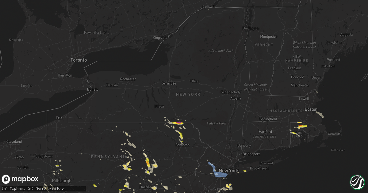
Hail Map in New York on June 29, 2019
Get this storm
June 29 map
$229
one time, instant access
Download today. No call, no setup
Keep the $229
Bought the map and want the full workflow? Apply the entire $229 to a subscription within 7 days. None of it is wasted.
Every map, not just this one
This buys you this map. Subscription and you get every map we run, in the markets you choose from a few cities to whole states to nationwide. Plus real-time alerts the moment a storm fires.
Contact data
Name, contact info, occupancy, even credit band for addresses in the footprint. You go from where it hit to who to call.
Become the source they trust
Unlimited branding weather history reports on demand. You already have the documented answer ready for the property owner, and you are the one who showed up with it.
Property data and RoofTrace estimates
Pull up any address you have got, its value and the exact code rules for that jurisdiction, straight from One Click Code. Then RoofTrace estimates the squares, pitch, and roof value, priced the way you price.
Storm reports in New York
New York
| Date | Description |
|---|---|
| 06/29/20196:39 PM CDT | Trees down |
| 06/29/20195:54 PM CDT | Tree/power line down |
| 06/29/20195:48 PM CDT | Tree and wire down. |
| 06/29/20194:42 PM CDT | Large branch down on shore parkway at coney island hospital with time estimated by radar |
| 06/29/20194:35 PM CDT | Large tree uprooted and laying across bavyiew street near the intersection of east blvd and bavyiew street with time estimated by radar |
| 06/29/20194:35 PM CDT | Large tree down on kermit place blocking the road. |
| 06/29/20194:20 PM CDT | A tree fell onto a car at caswell avenue and livermore avenue. The road is also blocked by the downed tree. |
| 06/29/20194:19 PM CDT | A tree fell on a house on windham loop. |
| 06/29/20194:18 PM CDT | Trees down on power lines around grand plaza with time estimated by radar |
| 06/29/20192:56 PM CDT | Large tree branches down between porch and fence with time estimated by radar |
| 06/29/20192:52 PM CDT | Hail with size larger than a quarter reported with time estimated by radar |
| 06/29/20191:42 PM CDT | Wires down on pennsylvania avenue |
| 06/29/20191:40 PM CDT | Multiple reports of trees down in apalachin area. Time estimated from radar. |
| 06/29/20191:38 PM CDT | Multiple reports of trees down in owego area. Time estimated from radar. |
| 06/29/20195:53 AM CDT | Several reports of wires down. Time estimated from radar. |
| 06/29/20194:38 AM CDT | Several reports of trees down |
| 06/29/20194:14 AM CDT | At 914 PM EDT, a severe thunderstorm was located near Lowville, or 18 miles southeast of Watertown, moving southeast at 40 mph. HAZARD...60 mph wind gusts. SOURCE...Radar indicated. IMPACT...Expect damage to roofs, siding, and trees. Locations impacted include... Lowville, Whetstone Gulf State Park, New Bremen, Watson, Martinsburg, Lyonsdale, Greig, Copenhagen, Port Leyden and Lyons Falls. |
| 06/29/20193:40 AM CDT | At 839 PM EDT, severe thunderstorms were located along a line extending from near Fowler to near Fort Drum, moving north at 80 mph. HAZARD...60 mph wind gusts and penny size hail. SOURCE...Radar indicated. IMPACT...Expect damage to roofs, siding, and trees. Locations impacted include... Carthage, West Carthage, Herrings, Denmark, New Bremen, Copenhagen, Harrisville, Croghan, Castorland and Belfort. |
| 06/29/20193:19 AM CDT | At 819 PM EDT, severe thunderstorms were located along a line extending from Redwood to Cedar Point State Park, moving southeast at 40 mph. HAZARD...60 mph wind gusts. SOURCE...Radar indicated. IMPACT...Expect damage to roofs, siding, and trees. Locations impacted include... Watertown, Fort Drum, Clayton, Dexter, Glen Park, Herrings, Redwood, Kring Point State Park, Wellesley Island State Park and Cedar Point State Park. This includes Interstate 81 between exits 43 and 52. |
| 06/29/20193:11 AM CDT | At 811 PM EDT, a severe thunderstorm was located near Bangor, moving southeast at 35 mph. HAZARD...60 mph wind gusts and quarter size hail. SOURCE...Radar indicated. IMPACT...Minor hail damage to vehicles is possible. Expect wind damage to trees and powerlines. Locations impacted include... Adirondack Regional Airport, Plattsburgh International Airport, Saranac Lake, Plattsburgh, Schuyler Falls, Saranac, Bangor, Parishville, Bryants Mill, Lyon Mountain, Clayburg, Debar Mountain, Dannemora, Peasleeville, Lake Ozonia, Madawaska, Harrietstown, Dickinson, Hopkinton and Santa Clara. |
| 06/29/20193:01 AM CDT | At 801 PM EDT, severe thunderstorms were located along a line extending from near Ogdensburg to 10 miles west of Cedar Island State Park, moving southeast at 35 mph. HAZARD...60 mph wind gusts and quarter size hail. SOURCE...Radar indicated. IMPACT...Minor hail damage to vehicles is possible. Expect wind damage to trees and powerlines. Locations impacted include... Gouverneur, Canton, Ogdensburg, Oswegatchie, Lisbon, De Kalb, Fowler, Colton, Morley, Degrasse, Carry Falls Reservoir, Richville, Hammond, Rensselaer Falls, Edwardsville, Hermon, Heuvelton, Star Lake, Morristown and Pierrepont. |
| 06/29/20192:30 AM CDT | At 730 PM EDT, a severe thunderstorm was located 8 miles north of Glen Park, or 11 miles northwest of Fort Drum, moving southeast at 30 mph. HAZARD...60 mph wind gusts and penny size hail. SOURCE...Radar indicated. IMPACT...Expect damage to roofs, siding, and trees. Locations impacted include... Watertown, Fort Drum, Herrings, Black River, Evans Mills, Deferiet, Great Bend, Calcium, Perch Lake and Rutland Center. This includes Interstate 81 between exits 47 and 48. |
| 06/29/20192:13 AM CDT | At 713 PM EDT, a severe thunderstorm was located 7 miles southwest of Gouverneur, moving southeast at 30 mph. HAZARD...60 mph wind gusts and nickel size hail. SOURCE...Radar indicated. IMPACT...Expect damage to roofs, siding, and trees. Locations impacted include... Carthage, West Carthage, Herrings, Denmark, Copenhagen, Harrisville, Croghan, Castorland, Deferiet and Belfort. |
| 06/29/20192:13 AM CDT | At 712 PM EDT, a severe thunderstorm was located over Hogansburg, moving east at 20 mph. HAZARD...60 mph wind gusts and quarter size hail. SOURCE...Radar indicated. IMPACT...Minor hail damage to vehicles is possible. Expect wind damage to trees and powerlines. Locations impacted include... Fort Covington, Bombay, Malone, Burke, St. Regis, Chateaugay, Helena, Brushton, Constable, Earlville, Fort Covington Center, Whippleville, South Bombay, Burke Center, Brasher Center, Hogansburg, Westville Center, St. Lawrence State Park, Ironton and Rooseveltown. |
| 06/29/20191:31 AM CDT | At 630 PM EDT, severe thunderstorms were located along a line extending from near Hammond to 11 miles northwest of Wellesley Island State Park, moving southeast at 35 mph. HAZARD...60 mph wind gusts and penny size hail. SOURCE...Radar indicated. IMPACT...Expect damage to roofs, siding, and trees. Locations impacted include... Fort Drum, Clayton, Herrings, Redwood, Kring Point State Park, Wellesley Island State Park, Cedar Point State Park, Black River, Philadelphia and Alexandria Bay. This includes Interstate 81 between exits 48 and 52. |
| 06/29/201912:28 AM CDT | At 528 PM EDT, a severe thunderstorm was located over Bay Ridge, or over The Verrazano Narrows Bridge, moving east at 45 mph. HAZARD...60 mph wind gusts and penny size hail. SOURCE...Radar indicated. IMPACT...Expect damage to trees and power lines. This severe thunderstorm will be near... Forest Hills and Canarsie around 540 PM EDT. Jamaica and Rockaway Beach around 545 PM EDT. Valley Stream and Lynbrook around 550 PM EDT. Long Beach and Oceanside around 555 PM EDT. |
| 06/28/201910:47 PM CDT | At 346 PM EDT, severe thunderstorms were located along a line extending from near Shehawken to near Gibson, moving southeast at 20 mph. HAZARD...Quarter size hail. SOURCE...Radar indicated. IMPACT...Damage to vehicles is expected. Locations impacted include... Honesdale, Damascus, Waymart, Hawley, Prompton, Bethany, Shehawken, Pleasant Mount, Rutledgedale and Browndale. |
| 06/28/201910:34 PM CDT | At 333 PM EDT, a severe thunderstorm was located over Baldwin, or over Lynbrook, moving east at 30 mph. HAZARD...60 mph wind gusts and penny size hail. SOURCE...Radar indicated. IMPACT...Expect damage to trees and power lines. This severe thunderstorm will be near... Levittown and Jones Beach around 350 PM EDT. Massapequa around 355 PM EDT. Farmingdale around 400 PM EDT. Amityville around 405 PM EDT. Lindenhurst and Gilgo State Park around 410 PM EDT. Islip and Babylon around 415 PM EDT. |
| 06/28/20199:20 PM CDT | At 219 PM EDT, severe thunderstorms were located along a line extending from near Spencer to near West Corners, moving southeast at 20 mph. HAZARD...60 mph wind gusts and quarter size hail. SOURCE...Radar indicated. IMPACT...Hail damage to vehicles is expected. Expect wind damage to roofs, siding, and trees. Locations impacted include... Vestal, Endicott, Owego, Spencer, Apalachin, Tioga Terrace, West Corners, Vestal Center, Endwell and Campville. |
| 06/28/20198:39 PM CDT | Tree down. |
| 06/28/20198:35 PM CDT | Trees and wires down on route 12 between glenfield and greig |
| 06/28/20197:34 PM CDT | A local report indicates 2.00 inch wind near RIVERSIDE |
| 06/28/20197:30 PM CDT | A local report indicates 1.75 inch wind near 1 E BLUE RIDGE MOBILE H |
| 06/28/20197:29 PM CDT | A local report indicates 1.25 inch wind near BLUE RIDGE MOBILE HOME |
All States Impacted by Hail Map on June 29, 2019
- Minnesota
- North Dakota
- New Jersey
- Oklahoma
- Texas
- Delaware
- Maryland
- Pennsylvania
- West Virginia
- Montana
- South Dakota
- Wisconsin
- New York
- Rhode Island
- Massachusetts
- Nebraska
- Illinois
- Virginia
- Ohio
- Wyoming
- Alabama
- Connecticut
- Florida
- Colorado
- Arkansas
- New Hampshire
- Georgia
- Mississippi
- Indiana
- Iowa
- Oregon
- Maine
- Kentucky
- Tennessee
- Louisiana
Cities Impacted by Hail Map on June 29, 2019
- Saint Vincent, MN
- Pembina, ND
- Lancaster, MN
- Sicklerville, NJ
- Blackwood, NJ
- Stringtown, OK
- Antlers, OK
- Daisy, OK
- Clayton, OK
- Lane, OK
- Atoka, OK
- Wolfe City, TX
- Dover, DE
- Middle River, MD
- Harmony, PA
- Fombell, PA
- Pasadena, MD
- Felton, MN
- Ponemah, MN
- Blackduck, MN
- Kelliher, MN
- Teague, TX
- Buffalo, TX
- Fairfield, TX
- Oakwood, TX
- Cummings, ND
- Mayville, ND
- Hillsboro, ND
- Portland, ND
- Richardton, ND
- Renovo, PA
- Beech Creek, PA
- Philadelphia, PA
- Waldorf, MD
- Grapeland, TX
- Houston, TX
- Pearland, TX
- Pennington, MN
- Deer River, MN
- Tenstrike, MN
- Marcell, MN
- Squaw Lake, MN
- Spring Lake, MN
- Max, MN
- Grand Rapids, MN
- Bemidji, MN
- Northome, MN
- Puposky, MN
- Talmoon, MN
- Bena, MN
- Bigfork, MN
- Hines, MN
- Cohasset, MN
- Bethany, WV
- Wellsburg, WV
- Belcamp, MD
- Bel Air, MD
- Aberdeen, MD
- Abingdon, MD
- Midlothian, TX
- Baytown, TX
- Plentywood, MT
- Webster, ND
- Coatesville, PA
- Parkesburg, PA
- Cammal, PA
- Elizabethville, PA
- Dalmatia, PA
- Mount Pleasant Mills, PA
- Port Trevorton, PA
- Liverpool, PA
- Martin, SD
- Allen, SD
- Decatur, TX
- Christiana, PA
- Strasburg, PA
- Ronks, PA
- Atglen, PA
- Paradise, PA
- Cochranville, PA
- Quarryville, PA
- Bruce, WI
- Weyerhaeuser, WI
- Conklin, NY
- Binghamton, NY
- Susquehanna, PA
- Brackney, PA
- Kirkwood, NY
- Hallstead, PA
- Windsor, NY
- Great Bend, PA
- Maddock, ND
- Lefor, ND
- Gunter, TX
- Howe, TX
- Sherman, TX
- Pawtucket, RI
- Johnston, RI
- Central Falls, RI
- Cumberland, RI
- North Attleboro, MA
- North Providence, RI
- Smithfield, RI
- Seekonk, MA
- Attleboro, MA
- Rehoboth, MA
- Providence, RI
- Lincoln, RI
- Snow, OK
- Winter, WI
- Ellsworth, NE
- Smyrna, DE
- Townsend, DE
- New Columbia, PA
- Watchung, NJ
- Plainfield, NJ
- Vincentown, NJ
- Manchester Township, NJ
- Glyndon, MN
- Webster, WI
- Salix, PA
- South Fork, PA
- Elton, PA
- Johnstown, PA
- Windber, PA
- Malden, IL
- Arlington, IL
- Spring Valley, IL
- Princeton, IL
- Cherry, IL
- Potter, NE
- Dalton, NE
- Gurley, NE
- Woodford, VA
- Fredericksburg, VA
- Crosby, ND
- Alamo, ND
- Crary, ND
- Starkweather, ND
- Devils Lake, ND
- Santa Fe, TX
- Alvin, TX
- Lansford, ND
- Maxbass, ND
- Redlake, MN
- Redby, MN
- Browns Mills, NJ
- Pemberton, NJ
- Nicholson, PA
- Kingsley, PA
- Factoryville, PA
- Fleetville, PA
- Dalton, PA
- Hop Bottom, PA
- Bellefonte, PA
- Centre Hall, PA
- State College, PA
- Kenmare, ND
- Ulster, PA
- Hammondsville, OH
- Carrollton, OH
- Kensington, OH
- Mechanicstown, OH
- Salineville, OH
- Victoria, TX
- Middle River, MN
- Gordon, NE
- Middletown, RI
- Brainerd, MN
- Lock Haven, PA
- Doylesburg, PA
- Blairs Mills, PA
- East Waterford, PA
- Blain, PA
- Mcville, ND
- Pekin, ND
- Massapequa Park, NY
- Farmingdale, NY
- Massapequa, NY
- Amityville, NY
- Lindenhurst, NY
- Copiague, NY
- Reading, PA
- Allenwood, PA
- Asbury Park, NJ
- West Long Branch, NJ
- Oakhurst, NJ
- Eatontown, NJ
- Exeland, WI
- Ojibwa, WI
- Radisson, WI
- Harrison, NE
- Lusk, WY
- Mercersburg, PA
- Towner, ND
- Rugby, ND
- Mott, ND
- Streetman, TX
- Goodridge, MN
- Corrigan, TX
- Diboll, TX
- Glenburn, ND
- Cooperstown, ND
- Finley, ND
- Hope, ND
- Waynesburg, OH
- Danville, IL
- Hoopeston, IL
- Rossville, IL
- Alvin, IL
- Bismarck, IL
- North Bend, PA
- Earleville, MD
- North East, MD
- Emory, TX
- La Grange, TX
- Giddings, TX
- Mylo, ND
- Flasher, ND
- Carson, ND
- Pingree, ND
- Danbury, WI
- Gordon, WI
- Carpenter, WY
- Watson, OK
- Powell, TX
- Kerens, TX
- Rice, TX
- Upperstrasburg, PA
- Fort Loudon, PA
- Bay City, TX
- Randolph, AL
- Penelope, TX
- Hubbard, TX
- Mertens, TX
- Frost, TX
- Malone, TX
- Laporte, MN
- Caney, OK
- Dallas, TX
- Hebron, ND
- New Leipzig, ND
- Canonsburg, PA
- Hainesport, NJ
- Mount Holly, NJ
- Lumberton, NJ
- Celeste, TX
- Farmersville, TX
- Milroy, PA
- Remer, MN
- Henning, IL
- Alexandria, VA
- Lewisburg, PA
- Canton, TX
- Bandera, TX
- Kutztown, PA
- Mertztown, PA
- Celina, TX
- Isle, MN
- Friendsville, PA
- Montrose, PA
- Ennis, TX
- Barry, TX
- Caddo Mills, TX
- Backus, MN
- Kilgore, NE
- Danville, PA
- Shrewsbury, NJ
- Long Branch, NJ
- Oceanport, NJ
- Red Bank, NJ
- Little Silver, NJ
- Deal, NJ
- Fort Monmouth, NJ
- Foster, RI
- Coventry, RI
- Greene, RI
- Saint Thomas, PA
- New Canaan, CT
- New Port Richey, FL
- Moundsville, WV
- Elgin, ND
- Colts Neck, NJ
- Monmouth Beach, NJ
- Rumson, NJ
- Bessemer, AL
- Oakman, AL
- Kemp, TX
- La Moille, IL
- Valley Stream, NY
- Lynbrook, NY
- West Hempstead, NY
- Malverne, NY
- Rockville Centre, NY
- Fleetwood, PA
- Shoemakersville, PA
- Willow City, ND
- Oxford, PA
- Elkton, MD
- Nottingham, PA
- Rising Sun, MD
- Warwick, MD
- Middletown, DE
- Chesapeake City, MD
- Winfield, PA
- Selinsgrove, PA
- Birchwood, WI
- Thief River Falls, MN
- Owego, NY
- Nichols, NY
- Jemison, AL
- Maplesville, AL
- Lawley, AL
- Brigantine, NJ
- Bottineau, ND
- Newburyport, MA
- Salisbury, MA
- Mifflintown, PA
- Atlanta, TX
- Cumby, TX
- Onarga, IL
- Gilman, IL
- Keller, TX
- Zahl, ND
- Grenora, ND
- Malvern, PA
- Monroeville, NJ
- Liverpool, TX
- Kearneysville, WV
- Kramer, ND
- Galeton, PA
- Nanticoke, MD
- Grampian, PA
- Freehold, NJ
- Jackson, NJ
- Curtis Bay, MD
- Newburg, ND
- Upham, ND
- Strasburg, CO
- Byers, CO
- Fort Washington, MD
- Shamokin, PA
- Sunbury, PA
- Paxinos, PA
- Courtenay, ND
- Spraggs, PA
- Waynesburg, PA
- Palestine, TX
- Trinity, TX
- Carr, CO
- Aliquippa, PA
- Taneytown, MD
- Keymar, MD
- Emily, MN
- Arley, AL
- Jasper, AL
- Gonvick, MN
- Hummelstown, PA
- Middletown, PA
- Harrisburg, PA
- Hershey, PA
- Elizabethtown, PA
- Clearbrook, MN
- Shermans Dale, PA
- New Bloomfield, PA
- Elliottsburg, PA
- Landisburg, PA
- Upper Marlboro, MD
- Bowie, MD
- Davidsonville, MD
- King George, VA
- Colbert, OK
- Hendrix, OK
- Calera, OK
- Durant, OK
- Huntsville, TX
- Knox, ND
- Leeds, ND
- Wolford, ND
- York, ND
- Spring Mills, PA
- Brooklyn, MD
- Greenville, TX
- Harrisburg, NE
- Palmyra, PA
- Montgomery, PA
- Ulysses, PA
- De Queen, AR
- Danforth, IL
- Kempton, IL
- Piper City, IL
- Merriman, NE
- Cody, NE
- Dayville, CT
- Danielson, CT
- Purdon, TX
- Dawson, TX
- Woonsocket, RI
- Sheyenne, ND
- Carrington, ND
- Lyme, NH
- East Rochester, OH
- Minerva, OH
- Paxton, IL
- Woodstown, NJ
- Swedesboro, NJ
- Mullica Hill, NJ
- Williamsport, MD
- Nashoba, OK
- Matagorda, TX
- Prince Frederick, MD
- Port Penn, DE
- New Castle, DE
- Longville, MN
- Marsland, NE
- Felton, DE
- Milford, DE
- Harrington, DE
- Frederica, DE
- New Rockford, ND
- Grygla, MN
- Cook, MN
- Mora, MN
- Rolette, ND
- Hawkinsville, GA
- Floodwood, MN
- Wright, MN
- Pine River, MN
- New Auburn, WI
- Chetek, WI
- Bokchito, OK
- Portal, ND
- Columbus, ND
- Noonan, ND
- Emmitsburg, MD
- Union Bridge, MD
- Westminster, MD
- Fessenden, ND
- Lititz, PA
- Valentine, NE
- Glady, WV
- Bowden, WV
- Venus, TX
- Lakota, ND
- Staten Island, NY
- Newfolden, MN
- Strandquist, MN
- Wimbledon, ND
- Tremont, MS
- Almont, ND
- Glen Ullin, ND
- Loganton, PA
- Mill Hall, PA
- Cohasset, MA
- Hull, MA
- Scituate, MA
- Morristown, IN
- Allentown, PA
- Lockesburg, AR
- Mizpah, MN
- Solway, MN
- Wirt, MN
- Bovey, MN
- Cass Lake, MN
- Jewett, TX
- Ganado, TX
- Rice Lake, WI
- Fairview, WV
- Wylie, TX
- Kerrville, TX
- Shevlin, MN
- Davenport, IA
- Walcott, IA
- Beulah, ND
- Dellroy, OH
- Brogue, PA
- Felton, PA
- Roseland, VA
- Tyro, VA
- Burnet, TX
- Jacobson, MN
- Lake Nebagamon, WI
- South Range, WI
- Poplar, WI
- Crookston, NE
- Amity, PA
- Clarksville, PA
- Prosperity, PA
- Jefferson, PA
- Washington, PA
- Marianna, PA
- Beach Haven, NJ
- Pasadena, TX
- Trego, WI
- Spooner, WI
- Dauphin, PA
- Halifax, PA
- Brownsville, PA
- East Millsboro, PA
- La Belle, PA
- Denbo, PA
- Woodway, TX
- Waco, TX
- Crawford, TX
- McGregor, TX
- Magnolia, DE
- Van Alstyne, TX
- Couderay, WI
- Hayward, WI
- Parsons, WV
- Stephen, MN
- Siren, WI
- Annawan, IL
- Pequot Lakes, MN
- Dwight, IL
- Locust Grove, OK
- Chouteau, OK
- Neptune, NJ
- Farmingdale, NJ
- Stevens, PA
- Newmanstown, PA
- Ephrata, PA
- Denver, PA
- Sisters, OR
- Tuthill, SD
- Shippensburg, PA
- Biglerville, PA
- Crosslake, MN
- La Porte, TX
- Seabrook, TX
- Lovelady, TX
- Springbrook, WI
- Gatzke, MN
- New Milford, PA
- Scio, OH
- Downingtown, PA
- Elverson, PA
- Morgantown, PA
- Glenmoore, PA
- Narvon, PA
- Honey Brook, PA
- Strathcona, MN
- Leonard, MN
- Brookston, MN
- Eustace, TX
- Bisbee, ND
- Fergus Falls, MN
- Perrysville, IN
- Georgetown, IL
- Cayuga, IN
- Justin, TX
- Haslet, TX
- Cullom, IL
- Callery, PA
- Evans City, PA
- Mars, PA
- Maud, TX
- Hooks, TX
- Cochran, GA
- Elm Mott, TX
- West, TX
- Clearville, PA
- Binford, ND
- Sutton, ND
- Glenfield, ND
- Cissna Park, IL
- Covington, IN
- Potomac, IL
- Rankin, IL
- Wellington, IL
- Williamsport, IN
- State Line, IN
- Lewisville, OH
- Summerfield, OH
- Bruceton Mills, WV
- Freeport, TX
- Morgantown, WV
- Dilliner, PA
- Maidsville, WV
- Mount Morris, PA
- Prosper, TX
- Anna, TX
- Crosby, MN
- Amsterdam, OH
- Lebanon, PA
- Chatsworth, NJ
- Barnegat, NJ
- Phoenixville, PA
- Chester Springs, PA
- Essex, MD
- Gunpowder, MD
- Rosedale, MD
- Minong, WI
- Merrifield, MN
- Glassboro, NJ
- Pitman, NJ
- Sewell, NJ
- Newport, NJ
- Elysburg, PA
- Vestal, NY
- Italy, TX
- Texarkana, TX
- Marietta, PA
- Mount Joy, PA
- Annapolis, MD
- Bowdoin, ME
- Litchfield, ME
- Sabattus, ME
- Elkins, WV
- Sabin, MN
- Hawley, MN
- Martinsburg, WV
- Inwood, WV
- Ranson, WV
- Charles Town, WV
- Shenandoah Junction, WV
- Parmelee, SD
- Manassas, VA
- Nashwauk, MN
- Hibbing, MN
- Grace City, ND
- Gibbon Glade, PA
- Farmington, PA
- Berkeley Springs, WV
- Mcgregor, MN
- Palisade, MN
- Williamstown, NJ
- Roseau, MN
- Plummer, MN
- Harwood, MD
- Edgewater, MD
- Nevada, TX
- Lusby, MD
- Hopkinsville, KY
- Manchester, NH
- Chester, NH
- Kingston, NH
- Auburn, NH
- Derry, NH
- Sandown, NH
- Londonderry, NH
- Danville, NH
- Cranberry Township, PA
- Baden, PA
- Freedom, PA
- Honey Grove, PA
- New Germantown, PA
- Newville, PA
- Oley, PA
- Petersburg, ND
- Davis, WV
- Eglon, WV
- Oakland, MD
- Cando, ND
- Neelyton, PA
- Dry Run, PA
- Cross Plains, TX
- Federal Dam, MN
- Finlayson, MN
- McGrath, MN
- Rome, PA
- Stillwater, PA
- Greencastle, PA
- Fairfield, PA
- Waynesboro, PA
- North Scituate, RI
- Chepachet, RI
- Millersville, PA
- Conestoga, PA
- Lancaster, PA
- Washington Boro, PA
- Candor, NY
- Saint Francis, SD
- Medford, NJ
- Casselton, ND
- Tamarack, MN
- Aurora, WV
- Terra Alta, WV
- Dornsife, PA
- Herndon, PA
- North Kingstown, RI
- Crane Hill, AL
- Boalsburg, PA
- Wilton, IA
- Moscow, IA
- Eagle Rock, VA
- Cove, AR
- Port Republic, MD
- Huntingtown, MD
- Oberon, ND
- Toulon, IL
- Galva, IL
- Badger, MN
- Norton, MA
- Greenville, RI
- Jamestown, ND
- Wellsville, OH
- Douglassville, TX
- Hull, TX
- Minnewaukan, ND
- Karlstad, MN
- Greenbush, MN
- Wrenshall, MN
- Barnum, MN
- Cloquet, MN
- Carlton, MN
- Joppa, MD
- Rushville, NE
- Covington, VA
- Memphis, TN
- Alto, TX
- Deerwood, MN
- Morristown, NJ
- Basking Ridge, NJ
- New Vernon, NJ
- Port Allegany, PA
- Malvern, OH
- Kitzmiller, MD
- Severn, MD
- Boonsboro, MD
- Corsicana, TX
- Burke, VA
- Fairfax Station, VA
- Springfield, VA
- Rappahannock Academy, VA
- Rock Island, IL
- Ambridge, PA
- Monaca, PA
- Sonora, KY
- Upton, KY
- Tolna, ND
- Park Rapids, MN
- Blooming Grove, TX
- Anamoose, ND
- Martin, ND
- Middleburg, PA
- Beavertown, PA
- Houston, PA
- Meadow Lands, PA
- Hickory, PA
- Trail, MN
- Gully, MN
- Valencia, PA
- Ohiopyle, PA
- Dunbar, PA
- Bynum, TX
- Pipe Creek, TX
- Mico, TX
- Saint Leonard, MD
- La Marque, TX
- Hitchcock, TX
- Texas City, TX
- Dickinson, TX
- Stone Lake, WI
- Anderson, TX
- Chesapeake Beach, MD
- Sunderland, MD
- Owings, MD
- Jermyn, PA
- Olyphant, PA
- Newton, NJ
- Andover, NJ
- Ironton, MN
- Aitkin, MN
- China Spring, TX
- Valley Mills, TX
- Stockton, IA
- Brandywine, MD
- Dunkirk, MD
- Holyoke, MN
- Conroe, TX
- Porter, TX
- Red Lake Falls, MN
- Blackstone, MA
- North Smithfield, RI
- Bellingham, MA
- Albright, WV
- Outing, MN
- Bagley, MN
- Swatara, MN
- Walker, MN
- Hill City, MN
- Galesburg, ND
- Clifford, ND
- Bedford, PA
- Pennsville, NJ
- Warren Center, PA
- Le Raysville, PA
- McVeytown, PA
- Lewistown, PA
- Meadowlands, MN
- Barnesville, MN
- Moorhead, MN
- Coudersport, PA
- Senecaville, OH
- Accident, MD
- Friendsville, MD
- McHenry, MD
- Swanton, MD
- Aquasco, MD
- Follansbee, WV
- Brilliant, OH
- Claysville, PA
- West Alexander, PA
- Mingo Junction, OH
- Steubenville, OH
- Colliers, WV
- Avella, PA
- Forreston, TX
- Waxahachie, TX
- Blue Grass, IA
- Bridgewater, NJ
- Bedminster, NJ
- Kerens, WV
- Montrose, WV
- Doddridge, AR
- Bivins, TX
- Rodessa, LA
- Jud, ND
- Kittery, ME
- Clarence, IA
- Tipton, IA
- Bennett, IA
- Shade Gap, PA
- Burnt Cabins, PA
- Orbisonia, PA
- Pontiac, IL
- Salem, NJ
- Bear, DE
- Red Oak, TX
- Monmouth, ME
- Greene, ME
- Burlington, WV
- Little Meadows, PA
- Apalachin, NY
- Cambridge, OH
- Dilworth, MN
- Williamsport, PA
- Alvarado, TX
- Crockett, TX
- West Branch, IA
- Ravenna, TX
- Coleman, TX
- Wickes, AR
- Gap, PA
- Willow River, MN
- Natural Dam, AR
- Chestertown, MD
- Coal Township, PA
- Northumberland, PA
- Milton, PA
- Millersburg, PA
- West Milton, PA
- Trevorton, PA
- Shamokin Dam, PA
- Holbrook, PA
- Lisbon, OH
- Hanoverton, OH
- Clinton, MD
- Bingham, NE
- Renfrew, PA
- Annville, PA
- League City, TX
- Denison, TX
- White Marsh, MD
- Nottingham, MD
- Niagara, ND
- Moatsville, WV
- Scurry, TX
- Cross Fork, PA
- Reserve, MT
- Succasunna, NJ
- Mine Hill, NJ
- Randolph, NJ
- Dover, NJ
- Stanhope, NJ
- Landing, NJ
- Mount Arlington, NJ
- Ledgewood, NJ
- Kenvil, NJ
- Jersey Mills, PA
- Waterville, PA
- Orrtanna, PA
- Gardners, PA
- Centreville, MD
- Church Hill, MD
- Howard, PA
- Madisonburg, PA
- Ladysmith, WI
- Burgettstown, PA
- Kemah, TX
- New Boston, TX
- Ashdown, AR
- Fort Worth, TX
- Grand Saline, TX
- Portersville, PA
- New Castle, PA
- Centerville, TX
- Wilmington, DE
- Esmond, ND
- Fincastle, VA
- Dudley, GA
- Forbes, MN
- Purgitsville, WV
- Cleveland, TX
- Stevensville, MD
- Saginaw, MN
- Alborn, MN
- Sandstone, MN
- Akeley, MN
- Wiggins, CO
- Granville, WV
- Willow Hill, PA
- Fannettsburg, PA
- Hackensack, MN
- Hope, RI
- Sterling, CT
- East Greenwich, RI
- West Warwick, RI
- Rio Medina, TX
- Mather, PA
- Fargo, ND
- Mapleton, ND
- West Fargo, ND
- Emington, IL
- Elkridge, MD
- Newark, DE
- Gatesville, TX
- Kinzers, PA
- Jacksonville, TX
- Slippery Rock, PA
- Warwick, ND
- Lancaster, TX
- Hutchins, TX
- Humble, TX
- Friendswood, TX
- Plainville, MA
- Commerce, TX
- Paw Paw, WV
- Bloomery, WV
- Talbotton, GA
- Plaza, ND
- Harvey, ND
- South Plainfield, NJ
- Dunellen, NJ
- Warren, NJ
- Piscataway, NJ
- Scotch Plains, NJ
- Rowlesburg, WV
- Jackson, PA
- Thompson, PA
- Keyser, WV
- Lexington, VA
- Glasgow, VA
- Natural Bridge, VA
- Kopperl, TX
- Center Point, TX
- Goldsboro, MD
- Henderson, MD
- Carrollton, TX
- The Colony, TX
- Blanchard, PA
- Wexford, PA
- Bradfordwoods, PA
- Butler, PA
- New Kensington, PA
- Newmarket, NH
- Durham, NH
- Outlook, MT
- Akron, OH
- Mount Wolf, PA
- Manchester, PA
- York, PA
- Andrews Air Force Base, MD
- Temple Hills, MD
- Suitland, MD
- Mckinney, TX
- Greenfield, IN
- Shelbyville, IN
- Fountaintown, IN
- Massena, NY
- Mitchell, OR
- Big Falls, MN
- Rusk, TX
- Chester, TX
- Glen Burnie, MD
- Tow, TX
- Glen Rose, TX
- Saint Hilaire, MN
- Parkville, MD
- Baltimore, MD
- Rockbridge Baths, VA
- Lampasas, TX
- Mchenry, ND
- Markleysburg, PA
- Woodbridge, VA
- Howell, NJ
- Belmar, NJ
- Tuscumbia, AL
- Beaver, PA
- Rochester, PA
- Mifflin, PA
- Sturgeon Lake, MN
- Gracey, KY
- Linden, TX
- Argyle, MN
- Easton, PA
- Bangor, PA
- Phillipsburg, NJ
- Paris, OH
- McDonald, PA
- Wheeling, WV
- Westport, PA
- Rocky Ridge, MD
- Thurmont, MD
- Selma, VA
- Effie, MN
- Gillham, AR
- Dunseith, ND
- Agate, ND
- Camden Wyoming, DE
- Clayton, DE
- Dover Afb, DE
- Hartly, DE
- Woodside, DE
- Marydel, MD
- Marydel, DE
- Viola, DE
- Cheswold, DE
- Scranton, PA
- Clarks Summit, PA
- Sugar Land, TX
- Drake, ND
- Donahue, IA
- Long Grove, IA
- Strattanville, PA
- Summerville, PA
- Spring Glen, PA
- Williamstown, PA
- Mountainburg, AR
- Cross Junction, VA
- McConnellsburg, PA
- Lawton, ND
- Hinckley, MN
- Kingsville, MD
- Perry Hall, MD
- Glen Arm, MD
- Upper Falls, MD
- Asbury, NJ
- Horatio, AR
- Haddonfield, NJ
- Oaklyn, NJ
- Audubon, NJ
- Collingswood, NJ
- Hopwood, PA
- Gaines, PA
- Portage, PA
- Hughesville, MD
- Mannington, WV
- Duncannon, PA
- Newport, PA
- Lincoln University, PA
- Landenberg, PA
- Three Springs, PA
- Silver Spring, MD
- Delaware City, DE
- Saint Georges, DE
- Bethpage, NY
- Exeter, NH
- East Kingston, NH
- Gladstone, ND
- Dickinson, ND
- Taylor, ND
- Mesquite, TX
- Carteret, NJ
- Middlesex, NJ
- Budd Lake, NJ
- Metuchen, NJ
- Gillette, NJ
- Rahway, NJ
- Elizabeth, NJ
- Colonia, NJ
- Millington, NJ
- Mendham, NJ
- Iselin, NJ
- Linden, NJ
- Fanwood, NJ
- Hopatcong, NJ
- Mountainside, NJ
- Westfield, NJ
- Avenel, NJ
- Clark, NJ
- Cranford, NJ
- Stirling, NJ
- Sewaren, NJ
- Garwood, NJ
- Flanders, NJ
- Denville, NJ
- Morris Plains, NJ
- Bayonne, NJ
- Edison, NJ
- Port Reading, NJ
- Fords, NJ
- Netcong, NJ
- Roselle, NJ
- Woodbridge, NJ
- Roselle Park, NJ
- Berkeley Heights, NJ
- Bernardsville, NJ
- Elizabethport, NJ
- Sidman, PA
- Chambersburg, PA
- Walnut Bottom, PA
- Pedricktown, NJ
- Berlin, NJ
- Arthur, ND
- Argusville, ND
- Harwood, ND
- Gardner, ND
- Georgetown, MN
- Grandin, ND
- Hunter, ND
- Amenia, ND
- Horace, ND
- Blanchard, ND


