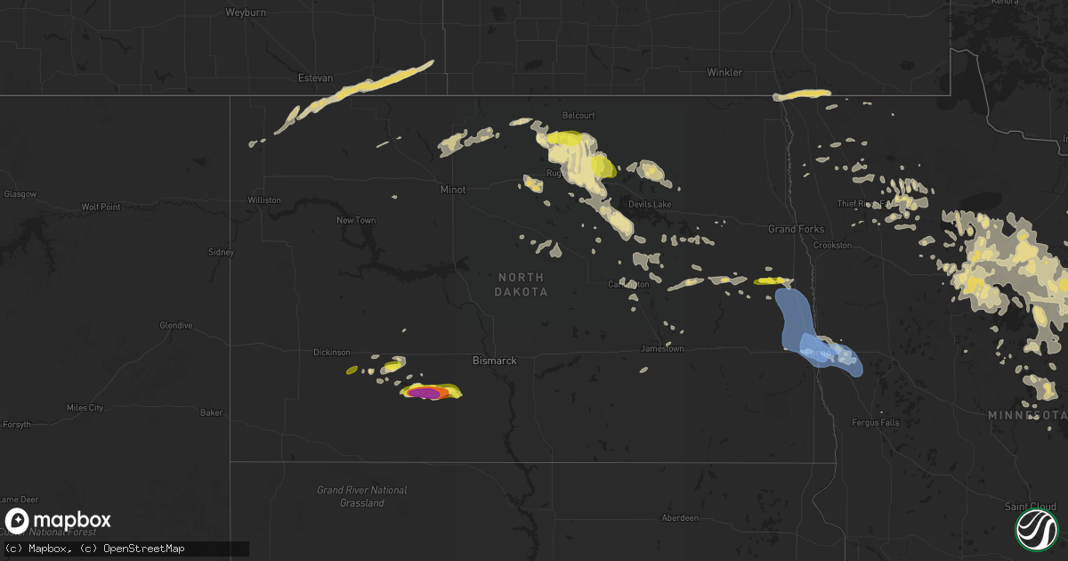
Hail Map in North Dakota on June 29, 2019
Get this storm
June 29 map
$229
one time, instant access
Download today. No call, no setup
Keep the $229
Bought the map and want the full workflow? Apply the entire $229 to a subscription within 7 days. None of it is wasted.
Every map, not just this one
This buys you this map. Subscription and you get every map we run, in the markets you choose from a few cities to whole states to nationwide. Plus real-time alerts the moment a storm fires.
Contact data
Name, contact info, occupancy, even credit band for addresses in the footprint. You go from where it hit to who to call.
Become the source they trust
Unlimited branding weather history reports on demand. You already have the documented answer ready for the property owner, and you are the one who showed up with it.
Property data and RoofTrace estimates
Pull up any address you have got, its value and the exact code rules for that jurisdiction, straight from One Click Code. Then RoofTrace estimates the squares, pitch, and roof value, priced the way you price.
Storm reports in North Dakota
North Dakota
| Date | Description |
|---|---|
| 06/29/20191:35 PM CDT | Report and photo posted via social media. Time estimated based on radar. |
| 06/29/20191:35 PM CDT | Report and photo posted via social media. Time estimated based on radar. |
| 06/29/20191:30 PM CDT | Report and photo posted via social media. Time estimated based on radar. |
| 06/29/20191:02 PM CDT | Peak winds measured at the fargo airport /kfar/. Several large trees were snapped in the north fargo area. |
| 06/29/201912:55 PM CDT | A pickup truck and trailer were blownover and blocking the northbound lane of interstate 28. Time estimated based on radar. |
| 06/29/201912:55 PM CDT | A pickup truck and trailer were blownover and blocking the northbound lane of interstate 28. Time estimated based on radar. A semi truck an trailer were also blown over |
| 06/29/201912:49 PM CDT | Tree branches up to baseball bat thickness /maximum 3 to 5 inch diamter/ were broken down by winds. |
| 06/29/201912:46 PM CDT | Peak winds measured at the fargo airport /kfar/. |
| 06/29/201912:45 PM CDT | Numerous large trees snapped around the city. A few garage doors were blown in and garage sidewalls blown out in at least two apartment complexes. A semi was tumbled on |
| 06/29/201912:35 PM CDT | Peak winds measured at the fargo airport /kfar/. |
| 06/29/201912:35 PM CDT | Winds at 40 mph gusting to 65 mph reported on the rwis station on the red river bridge. |
| 06/29/201912:34 PM CDT | Power poles broken and small trees snapped in south fargo. |
| 06/29/201912:28 PM CDT | Shingles and construction materials flying in the winds. Multiple spotter report winds gusting to 60 mph or higher. |
| 06/29/201912:25 PM CDT | Several 3 to 5 inch diameter tree branches broken down. |
| 06/29/201912:03 PM CDT | A local report indicates 58 MPH wind near 5 NW PROSPER |
| 06/29/201912:00 PM CDT | Peak winds measured by a mobile mesonet station. |
| 06/29/201910:45 AM CDT | Severe winds... Torrential rains... And marble sized hail were reported. |
| 06/29/201910:40 AM CDT | Peak winds measured. Noted that four 9 inch diameter pine trees were snapped at the base around 1033 am cdt. |
| 06/29/201910:33 AM CDT | Peak winds measured. Noted that four 9 inch diameter pine trees were snapped at the base around 1033 am cdt. |
| 06/29/201910:07 AM CDT | Delayed report. |
| 06/29/20199:25 AM CDT | Several large branches were broken down along with torrential rains and some pea to penny sized hail across northern freeborn township... From about 920 through 930 am |
| 06/29/20198:50 AM CDT | A few large tree 3 to 5 inch diameter branches broken down... Along with some dime to nickel sized hail and very heavy rains. Wind was very strong between 845 and 9 am |
| 06/29/20198:02 AM CDT | Large tree branches and limbs broken down. Winds estimated to 60 mph or greater. |
| 06/29/20197:53 AM CDT | At 1252 PM CDT, a severe thunderstorm was located near Finley, or 40 miles north of Valley City, moving east at 45 mph. HAZARD...Quarter size hail. SOURCE...Radar indicated. IMPACT...Damage to vehicles is expected. This severe thunderstorm will be near... Finley and Sharon around 100 PM CDT. Sherbrooke around 105 PM CDT. Golden Lake around 115 PM CDT. Hatton around 125 PM CDT. Mayville and Portland around 130 PM CDT. |
| 06/29/20197:50 AM CDT | Strong winds and torrential rains occurred with the hail. |
| 06/29/20197:50 AM CDT | Trained storm spotter reported thunderstorm wind damage in wolford with a tree split in half... Mid-way up the tree trunk. Small and large branches were also broken off |
| 06/29/20197:37 AM CDT | At 1237 PM CDT, a severe thunderstorm was located near Jessie, or 39 miles north of Valley City, moving east at 35 mph. HAZARD...Quarter size hail. SOURCE...Radar indicated. IMPACT...Damage to vehicles is expected. This severe thunderstorm will be near... Cooperstown around 1245 PM CDT. |
| 06/29/20197:34 AM CDT | Reports of dime to quarter sized hail and very heavy rain. |
| 06/29/20197:33 AM CDT | At 1233 PM CDT, severe thunderstorms were located along a line extending from near West Fargo to near Kindred, moving east at 25 mph. HAZARD...60 mph wind gusts. SOURCE...Trained weather spotters. IMPACT...Expect damage to roofs, siding, and trees. Severe thunderstorms will be near... West Fargo around 1235 PM CDT. Reile's Acres and Horace around 1240 PM CDT. Hickson, Fargo and Prairie Rose around 1245 PM CDT. Oxbow, Oakport and Wild Rice around 1250 PM CDT. Moorhead, Comstock and Rustad around 1255 PM CDT.Other locations impacted by these severe thunderstorms includeMoorhead Airport.This includes the following highways... Interstate 29 between mile markers 49 and 68. Interstate 94 in North Dakota between mile markers 341 and 352. Interstate 94 in Minnesota between mile markers 1 and 25. |
| 06/29/20195:01 AM CDT | At 1001 AM CDT, a severe thunderstorm was located near Lansford, or 13 miles southeast of Mohall, moving northeast at 55 mph. HAZARD...Quarter size hail. SOURCE...Radar indicated. IMPACT...Damage to vehicles is expected. This severe thunderstorm will be near... Maxbass around 1010 AM CDT. Newburg around 1020 AM CDT.Other locations impacted by this severe thunderstorm include Eckman,Russell and Landa. |
| 06/29/20194:58 AM CDT | At 957 AM CDT, severe thunderstorms were located along a line extending from near Adams to 7 miles south of Mapes to Glenfield, moving east at 35 mph. HAZARD...60 mph wind gusts and quarter size hail. SOURCE...Radar indicated. IMPACT...Hail damage to vehicles is expected. Expect wind damage to roofs, siding, and trees. Severe thunderstorms will be near... Mapes around 1000 AM CDT. Adams and Michigan around 1005 AM CDT. Petersburg and Binford around 1015 AM CDT. Lankin and Niagara around 1020 AM CDT. Jessie around 1025 AM CDT. |
| 06/29/20194:13 AM CDT | At 913 AM CDT, severe thunderstorms were located along a line extending from near Lawton to Warwick to near Carrington, moving southeast at 35 mph. HAZARD...60 mph wind gusts and quarter size hail. SOURCE...Radar indicated. IMPACT...Hail damage to vehicles is expected. Expect wind damage to roofs, siding, and trees. Severe thunderstorms will be near... Warwick around 915 AM CDT. Hamar around 920 AM CDT. Tolna around 925 AM CDT. Brocket around 930 AM CDT. Red Willow Lake, Whitman and Mose around 945 AM CDT. |
| 06/29/20193:45 AM CDT | At 844 AM CDT, severe thunderstorms were located along a line extending from near Starkweather to near Minnewaukan to Hamberg, moving southeast at 35 mph. HAZARD...60 mph wind gusts and quarter size hail. SOURCE...Radar indicated. IMPACT...Hail damage to vehicles is expected. Expect wind damage to roofs, siding, and trees. Severe thunderstorms will be near... Starkweather around 845 AM CDT. Grahams Island State Park around 850 AM CDT. Fort Totten, Lakewood Park and Devils Lake around 855 AM CDT. St Michael, Camp Grafton and Derrick around 900 AM CDT. Tokio around 905 AM CDT. |
| 06/29/20193:33 AM CDT | At 833 PM CDT, a severe thunderstorm was located near Flasher, or 26 miles east of Elgin, moving east at 30 mph. HAZARD...Two inch hail and 70 mph wind gusts. SOURCE...Trained weather spotters. IMPACT...People and animals outdoors will be injured. Expect hail damage to roofs, siding, windows, and vehicles. Expect considerable tree damage. Wind damage is also likely to mobile homes, roofs, and outbuildings. This severe thunderstorm will be near... Flasher around 840 PM CDT. St. Anthony around 915 PM CDT. |
| 06/29/20193:07 AM CDT | At 806 AM CDT, severe thunderstorms were located along a line extending from near Perth to near Maza to 6 miles south of Esmond, moving east at 30 mph. HAZARD...60 mph wind gusts and quarter size hail. SOURCE...Radar indicated. IMPACT...Hail damage to vehicles is expected. Expect wind damage to roofs, siding, and trees. Severe thunderstorms will be near... Cando around 815 AM CDT. Maza, Rocklake and Churchs Ferry around 820 AM CDT. Maddock and Arndt around 830 AM CDT. Egeland and Flora around 840 AM CDT. Webster and Garske around 850 AM CDT. |
| 06/29/20192:43 AM CDT | At 743 AM CDT, severe thunderstorms were located along a line extending from near Rolette to 7 miles northeast of Wolford to 12 miles northwest of Leeds, moving northeast at 30 mph. HAZARD...60 mph wind gusts and quarter size hail. SOURCE...Radar indicated. IMPACT...Hail damage to vehicles is expected. Expect wind damage to roofs, siding, and trees. Severe thunderstorms will be near... Belcourt around 755 AM CDT. Rolla around 810 AM CDT.Other locations impacted by these severe thunderstorms include Agate,Thorne, Nanson, Mylo and Shell Valley. |
| 06/29/20192:18 AM CDT | At 717 AM CDT, severe thunderstorms were located along a line extending from near Shell Valley to near Pleasant Lake to Orrin, moving east at 45 mph. HAZARD...70 mph wind gusts and quarter size hail. SOURCE...Radar indicated. IMPACT...Hail damage to vehicles is expected. Expect considerable tree damage. Wind damage is also likely to mobile homes, roofs, and outbuildings. Severe thunderstorms will be near... Pleasant Lake around 725 AM CDT. Knox around 730 AM CDT. York around 740 AM CDT. Esmond, Leeds and Perth around 745 AM CDT. Bisbee, Brinsmade and Rocklake around 755 AM CDT. |
| 06/29/20192:03 AM CDT | At 702 PM CDT/602 PM MDT/, a severe thunderstorm was located 10 miles southwest of Glen Ullin, moving east at 30 mph. HAZARD...60 mph wind gusts and half dollar size hail. SOURCE...Radar indicated. IMPACT...Hail damage to vehicles is expected. Expect wind damage to roofs, siding, and trees. This severe thunderstorm will be near... Glen Ullin around 720 PM CDT. Almont around 745 PM CDT. New Salem around 755 PM CDT. |
| 06/29/20191:50 AM CDT | At 648 AM CDT, severe thunderstorms were located along a line extending from near Bottineau to 7 miles north of Towner to 5 miles north of Karlsruhe, moving east at 50 mph. HAZARD...70 mph wind gusts and quarter size hail. SOURCE...Radar indicated. IMPACT...Hail damage to vehicles is expected. Expect considerable tree damage. Wind damage is also likely to mobile homes, roofs, and outbuildings. Severe thunderstorms will be near... Barton around 700 AM CDT. Rugby and Dunseith around 710 AM CDT. Rolette and Balta around 720 AM CDT. Wolford and Belcourt around 725 AM CDT. Rolla around 735 AM CDT.Other locations impacted by these severe thunderstorms includeNanson, Silva, Shell Valley, Agate, Thorne, Mylo and Overly. |
| 06/29/20191:30 AM CDT | At 630 PM MDT, a severe thunderstorm was located near Heart Butte Dam, or 10 miles north of Elgin, moving east at 25 mph. HAZARD...Ping pong ball size hail and 60 mph wind gusts. SOURCE...Radar indicated. IMPACT...People and animals outdoors will be injured. Expect hail damage to roofs, siding, windows, and vehicles. Expect wind damage to roofs, siding, and trees. This severe thunderstorm will remain over mainly rural areas of northwestern Grant County, including the following locations... Lark. |
| 06/29/20191:09 AM CDT | At 609 AM CDT, severe thunderstorms were located along a line extending from 4 miles north of Maxbass to near Deering to 6 miles south of Minot, moving east at 45 mph. HAZARD...70 mph wind gusts and quarter size hail. SOURCE...Radar indicated. IMPACT...Hail damage to vehicles is expected. Expect considerable tree damage. Wind damage is also likely to mobile homes, roofs, and outbuildings. Severe thunderstorms will be near... Deering around 615 AM CDT. Surrey around 620 AM CDT. Granville and Newburg around 625 AM CDT. Denbigh around 640 AM CDT. Bottineau and Towner around 650 AM CDT.Other locations impacted by these severe thunderstorms includeCarbury, Russell, Logan, Wolseth, Norwich, Bantry, Omemee, Gardena,Berwick and Eckman. |
| 06/29/201912:29 AM CDT | At 528 AM CDT, severe thunderstorms were located along a line extending from near Donnybrook to near Berthold to 10 miles north of Plaza, moving east at 40 mph. HAZARD...60 mph wind gusts and quarter size hail. SOURCE...Radar indicated. IMPACT...Hail damage to vehicles is expected. Expect wind damage to roofs, siding, and trees. Severe thunderstorms will be near... Berthold and Carpio around 535 AM CDT. Foxholm around 545 AM CDT. Des Lacs around 555 AM CDT. Minot Air Force Base around 600 AM CDT. Burlington around 605 AM CDT. Glenburn around 615 AM CDT. Minot around 620 AM CDT. Surrey around 630 AM CDT.Other locations impacted by these severe thunderstorms includeHartland, Logan, Coulee and Wolseth. |
| 06/29/201912:11 AM CDT | At 511 AM CDT, a severe thunderstorm was located 5 miles south of Palermo, or 9 miles east of Stanley, moving east at 20 mph. HAZARD...60 mph wind gusts and quarter size hail. SOURCE...Radar indicated. IMPACT...Hail damage to vehicles is expected. Expect wind damage to roofs, siding, and trees. This severe thunderstorm will be near... Blaisdell around 530 AM CDT.Other locations impacted by this severe thunderstorm include Couleeand Tagus. |
| 06/29/201912:11 AM CDT | At 511 PM MDT, a severe thunderstorm was located 9 miles southeast of Gladstone, or 18 miles southeast of Dickinson, moving east at 30 mph. HAZARD...Ping pong ball size hail and 60 mph wind gusts. SOURCE...Radar indicated. IMPACT...People and animals outdoors will be injured. Expect hail damage to roofs, siding, windows, and vehicles. Expect wind damage to roofs, siding, and trees. This severe thunderstorm will be near... Richardton around 530 PM MDT.Other locations impacted by this severe thunderstorm include Lefor. |
| 06/28/201911:40 PM CDT | At 440 AM CDT, a severe thunderstorm was located 7 miles west of Ross, or 15 miles west of Stanley, moving east at 20 mph. HAZARD...60 mph wind gusts and half dollar size hail. SOURCE...Radar indicated. IMPACT...Hail damage to vehicles is expected. Expect wind damage to roofs, siding, and trees. This severe thunderstorm will be near... Ross around 505 AM CDT. Stanley around 525 AM CDT. Palermo around 545 AM CDT.Other locations impacted by this severe thunderstorm include WhiteEarth. |
| 06/28/201911:08 PM CDT | At 408 AM CDT, a severe thunderstorm was located 5 miles southwest of Lostwood, or 9 miles northwest of Stanley, moving northeast at 20 mph. HAZARD...Quarter size hail. SOURCE...Radar indicated. IMPACT...Damage to vehicles is expected. This severe thunderstorm will be near... Lostwood around 425 AM CDT. |
| 06/28/201910:53 PM CDT | At 352 AM CDT, a severe thunderstorm was located 7 miles southeast of Epping, or 15 miles east of Williston, moving east at 30 mph. HAZARD...Quarter size hail. SOURCE...Radar indicated. IMPACT...Damage to vehicles is expected. This severe thunderstorm will remain over mainly rural areas of southeastern Williams County, including the following locations... White Tail Bay Recreation Area and Lewis And Clark State Park. |
| 06/28/201910:26 PM CDT | At 325 PM CDT, a severe thunderstorm was located 6 miles northeast of Noonan, or 17 miles east of Crosby, moving northeast at 35 mph. HAZARD...60 mph wind gusts and quarter size hail. SOURCE...Radar indicated. IMPACT...Hail damage to vehicles is expected. Expect wind damage to roofs, siding, and trees. This severe thunderstorm will be near... Columbus around 330 PM CDT.Other locations impacted by this severe thunderstorm include Larson. |
| 06/28/201910:21 PM CDT | At 320 AM MDT, a severe thunderstorm was located near Sidney, moving east at 35 mph. HAZARD...Quarter size hail. SOURCE...Radar indicated. IMPACT...Damage to vehicles is expected. Locations impacted include... Sidney and Wooley. |
| 06/28/201910:10 PM CDT | At 310 AM CDT, a severe thunderstorm was located 6 miles east of Alamo, or 22 miles south of Crosby, moving northeast at 35 mph. HAZARD...Quarter size hail. SOURCE...Radar indicated. IMPACT...Damage to vehicles is expected. This severe thunderstorm will be near... Wildrose around 320 AM CDT.Other locations impacted by this severe thunderstorm include Corinth,Hamlet and Mcgregor. |
| 06/28/20199:53 PM CDT | At 253 PM CDT, a severe thunderstorm was located near Crosby, moving northeast at 25 mph. HAZARD...60 mph wind gusts and quarter size hail. SOURCE...Radar indicated. IMPACT...Hail damage to vehicles is expected. Expect wind damage to roofs, siding, and trees. This severe thunderstorm will be near... Noonan around 310 PM CDT. |
| 06/28/20198:41 PM CDT | A local report indicates 1.50 inch wind near 8 N LARK |
| 06/28/20198:20 PM CDT | Estimated distance north of carson with radar. Estimated hail size by picture. Report relayed by broadcast media. |
| 06/28/20198:13 PM CDT | Via nws chat. |
All States Impacted by Hail Map on June 29, 2019
- Minnesota
- North Dakota
- New Jersey
- Oklahoma
- Texas
- Delaware
- Maryland
- Pennsylvania
- West Virginia
- Montana
- South Dakota
- Wisconsin
- New York
- Rhode Island
- Massachusetts
- Nebraska
- Illinois
- Virginia
- Ohio
- Wyoming
- Alabama
- Connecticut
- Florida
- Colorado
- Arkansas
- New Hampshire
- Georgia
- Mississippi
- Indiana
- Iowa
- Oregon
- Maine
- Kentucky
- Tennessee
- Louisiana
Cities Impacted by Hail Map on June 29, 2019
- Saint Vincent, MN
- Pembina, ND
- Lancaster, MN
- Sicklerville, NJ
- Blackwood, NJ
- Stringtown, OK
- Antlers, OK
- Daisy, OK
- Clayton, OK
- Lane, OK
- Atoka, OK
- Wolfe City, TX
- Dover, DE
- Middle River, MD
- Harmony, PA
- Fombell, PA
- Pasadena, MD
- Felton, MN
- Ponemah, MN
- Blackduck, MN
- Kelliher, MN
- Teague, TX
- Buffalo, TX
- Fairfield, TX
- Oakwood, TX
- Cummings, ND
- Mayville, ND
- Hillsboro, ND
- Portland, ND
- Richardton, ND
- Renovo, PA
- Beech Creek, PA
- Philadelphia, PA
- Waldorf, MD
- Grapeland, TX
- Houston, TX
- Pearland, TX
- Pennington, MN
- Deer River, MN
- Tenstrike, MN
- Marcell, MN
- Squaw Lake, MN
- Spring Lake, MN
- Max, MN
- Grand Rapids, MN
- Bemidji, MN
- Northome, MN
- Puposky, MN
- Talmoon, MN
- Bena, MN
- Bigfork, MN
- Hines, MN
- Cohasset, MN
- Bethany, WV
- Wellsburg, WV
- Belcamp, MD
- Bel Air, MD
- Aberdeen, MD
- Abingdon, MD
- Midlothian, TX
- Baytown, TX
- Plentywood, MT
- Webster, ND
- Coatesville, PA
- Parkesburg, PA
- Cammal, PA
- Elizabethville, PA
- Dalmatia, PA
- Mount Pleasant Mills, PA
- Port Trevorton, PA
- Liverpool, PA
- Martin, SD
- Allen, SD
- Decatur, TX
- Christiana, PA
- Strasburg, PA
- Ronks, PA
- Atglen, PA
- Paradise, PA
- Cochranville, PA
- Quarryville, PA
- Bruce, WI
- Weyerhaeuser, WI
- Conklin, NY
- Binghamton, NY
- Susquehanna, PA
- Brackney, PA
- Kirkwood, NY
- Hallstead, PA
- Windsor, NY
- Great Bend, PA
- Maddock, ND
- Lefor, ND
- Gunter, TX
- Howe, TX
- Sherman, TX
- Pawtucket, RI
- Johnston, RI
- Central Falls, RI
- Cumberland, RI
- North Attleboro, MA
- North Providence, RI
- Smithfield, RI
- Seekonk, MA
- Attleboro, MA
- Rehoboth, MA
- Providence, RI
- Lincoln, RI
- Snow, OK
- Winter, WI
- Ellsworth, NE
- Smyrna, DE
- Townsend, DE
- New Columbia, PA
- Watchung, NJ
- Plainfield, NJ
- Vincentown, NJ
- Manchester Township, NJ
- Glyndon, MN
- Webster, WI
- Salix, PA
- South Fork, PA
- Elton, PA
- Johnstown, PA
- Windber, PA
- Malden, IL
- Arlington, IL
- Spring Valley, IL
- Princeton, IL
- Cherry, IL
- Potter, NE
- Dalton, NE
- Gurley, NE
- Woodford, VA
- Fredericksburg, VA
- Crosby, ND
- Alamo, ND
- Crary, ND
- Starkweather, ND
- Devils Lake, ND
- Santa Fe, TX
- Alvin, TX
- Lansford, ND
- Maxbass, ND
- Redlake, MN
- Redby, MN
- Browns Mills, NJ
- Pemberton, NJ
- Nicholson, PA
- Kingsley, PA
- Factoryville, PA
- Fleetville, PA
- Dalton, PA
- Hop Bottom, PA
- Bellefonte, PA
- Centre Hall, PA
- State College, PA
- Kenmare, ND
- Ulster, PA
- Hammondsville, OH
- Carrollton, OH
- Kensington, OH
- Mechanicstown, OH
- Salineville, OH
- Victoria, TX
- Middle River, MN
- Gordon, NE
- Middletown, RI
- Brainerd, MN
- Lock Haven, PA
- Doylesburg, PA
- Blairs Mills, PA
- East Waterford, PA
- Blain, PA
- Mcville, ND
- Pekin, ND
- Massapequa Park, NY
- Farmingdale, NY
- Massapequa, NY
- Amityville, NY
- Lindenhurst, NY
- Copiague, NY
- Reading, PA
- Allenwood, PA
- Asbury Park, NJ
- West Long Branch, NJ
- Oakhurst, NJ
- Eatontown, NJ
- Exeland, WI
- Ojibwa, WI
- Radisson, WI
- Harrison, NE
- Lusk, WY
- Mercersburg, PA
- Towner, ND
- Rugby, ND
- Mott, ND
- Streetman, TX
- Goodridge, MN
- Corrigan, TX
- Diboll, TX
- Glenburn, ND
- Cooperstown, ND
- Finley, ND
- Hope, ND
- Waynesburg, OH
- Danville, IL
- Hoopeston, IL
- Rossville, IL
- Alvin, IL
- Bismarck, IL
- North Bend, PA
- Earleville, MD
- North East, MD
- Emory, TX
- La Grange, TX
- Giddings, TX
- Mylo, ND
- Flasher, ND
- Carson, ND
- Pingree, ND
- Danbury, WI
- Gordon, WI
- Carpenter, WY
- Watson, OK
- Powell, TX
- Kerens, TX
- Rice, TX
- Upperstrasburg, PA
- Fort Loudon, PA
- Bay City, TX
- Randolph, AL
- Penelope, TX
- Hubbard, TX
- Mertens, TX
- Frost, TX
- Malone, TX
- Laporte, MN
- Caney, OK
- Dallas, TX
- Hebron, ND
- New Leipzig, ND
- Canonsburg, PA
- Hainesport, NJ
- Mount Holly, NJ
- Lumberton, NJ
- Celeste, TX
- Farmersville, TX
- Milroy, PA
- Remer, MN
- Henning, IL
- Alexandria, VA
- Lewisburg, PA
- Canton, TX
- Bandera, TX
- Kutztown, PA
- Mertztown, PA
- Celina, TX
- Isle, MN
- Friendsville, PA
- Montrose, PA
- Ennis, TX
- Barry, TX
- Caddo Mills, TX
- Backus, MN
- Kilgore, NE
- Danville, PA
- Shrewsbury, NJ
- Long Branch, NJ
- Oceanport, NJ
- Red Bank, NJ
- Little Silver, NJ
- Deal, NJ
- Fort Monmouth, NJ
- Foster, RI
- Coventry, RI
- Greene, RI
- Saint Thomas, PA
- New Canaan, CT
- New Port Richey, FL
- Moundsville, WV
- Elgin, ND
- Colts Neck, NJ
- Monmouth Beach, NJ
- Rumson, NJ
- Bessemer, AL
- Oakman, AL
- Kemp, TX
- La Moille, IL
- Valley Stream, NY
- Lynbrook, NY
- West Hempstead, NY
- Malverne, NY
- Rockville Centre, NY
- Fleetwood, PA
- Shoemakersville, PA
- Willow City, ND
- Oxford, PA
- Elkton, MD
- Nottingham, PA
- Rising Sun, MD
- Warwick, MD
- Middletown, DE
- Chesapeake City, MD
- Winfield, PA
- Selinsgrove, PA
- Birchwood, WI
- Thief River Falls, MN
- Owego, NY
- Nichols, NY
- Jemison, AL
- Maplesville, AL
- Lawley, AL
- Brigantine, NJ
- Bottineau, ND
- Newburyport, MA
- Salisbury, MA
- Mifflintown, PA
- Atlanta, TX
- Cumby, TX
- Onarga, IL
- Gilman, IL
- Keller, TX
- Zahl, ND
- Grenora, ND
- Malvern, PA
- Monroeville, NJ
- Liverpool, TX
- Kearneysville, WV
- Kramer, ND
- Galeton, PA
- Nanticoke, MD
- Grampian, PA
- Freehold, NJ
- Jackson, NJ
- Curtis Bay, MD
- Newburg, ND
- Upham, ND
- Strasburg, CO
- Byers, CO
- Fort Washington, MD
- Shamokin, PA
- Sunbury, PA
- Paxinos, PA
- Courtenay, ND
- Spraggs, PA
- Waynesburg, PA
- Palestine, TX
- Trinity, TX
- Carr, CO
- Aliquippa, PA
- Taneytown, MD
- Keymar, MD
- Emily, MN
- Arley, AL
- Jasper, AL
- Gonvick, MN
- Hummelstown, PA
- Middletown, PA
- Harrisburg, PA
- Hershey, PA
- Elizabethtown, PA
- Clearbrook, MN
- Shermans Dale, PA
- New Bloomfield, PA
- Elliottsburg, PA
- Landisburg, PA
- Upper Marlboro, MD
- Bowie, MD
- Davidsonville, MD
- King George, VA
- Colbert, OK
- Hendrix, OK
- Calera, OK
- Durant, OK
- Huntsville, TX
- Knox, ND
- Leeds, ND
- Wolford, ND
- York, ND
- Spring Mills, PA
- Brooklyn, MD
- Greenville, TX
- Harrisburg, NE
- Palmyra, PA
- Montgomery, PA
- Ulysses, PA
- De Queen, AR
- Danforth, IL
- Kempton, IL
- Piper City, IL
- Merriman, NE
- Cody, NE
- Dayville, CT
- Danielson, CT
- Purdon, TX
- Dawson, TX
- Woonsocket, RI
- Sheyenne, ND
- Carrington, ND
- Lyme, NH
- East Rochester, OH
- Minerva, OH
- Paxton, IL
- Woodstown, NJ
- Swedesboro, NJ
- Mullica Hill, NJ
- Williamsport, MD
- Nashoba, OK
- Matagorda, TX
- Prince Frederick, MD
- Port Penn, DE
- New Castle, DE
- Longville, MN
- Marsland, NE
- Felton, DE
- Milford, DE
- Harrington, DE
- Frederica, DE
- New Rockford, ND
- Grygla, MN
- Cook, MN
- Mora, MN
- Rolette, ND
- Hawkinsville, GA
- Floodwood, MN
- Wright, MN
- Pine River, MN
- New Auburn, WI
- Chetek, WI
- Bokchito, OK
- Portal, ND
- Columbus, ND
- Noonan, ND
- Emmitsburg, MD
- Union Bridge, MD
- Westminster, MD
- Fessenden, ND
- Lititz, PA
- Valentine, NE
- Glady, WV
- Bowden, WV
- Venus, TX
- Lakota, ND
- Staten Island, NY
- Newfolden, MN
- Strandquist, MN
- Wimbledon, ND
- Tremont, MS
- Almont, ND
- Glen Ullin, ND
- Loganton, PA
- Mill Hall, PA
- Cohasset, MA
- Hull, MA
- Scituate, MA
- Morristown, IN
- Allentown, PA
- Lockesburg, AR
- Mizpah, MN
- Solway, MN
- Wirt, MN
- Bovey, MN
- Cass Lake, MN
- Jewett, TX
- Ganado, TX
- Rice Lake, WI
- Fairview, WV
- Wylie, TX
- Kerrville, TX
- Shevlin, MN
- Davenport, IA
- Walcott, IA
- Beulah, ND
- Dellroy, OH
- Brogue, PA
- Felton, PA
- Roseland, VA
- Tyro, VA
- Burnet, TX
- Jacobson, MN
- Lake Nebagamon, WI
- South Range, WI
- Poplar, WI
- Crookston, NE
- Amity, PA
- Clarksville, PA
- Prosperity, PA
- Jefferson, PA
- Washington, PA
- Marianna, PA
- Beach Haven, NJ
- Pasadena, TX
- Trego, WI
- Spooner, WI
- Dauphin, PA
- Halifax, PA
- Brownsville, PA
- East Millsboro, PA
- La Belle, PA
- Denbo, PA
- Woodway, TX
- Waco, TX
- Crawford, TX
- McGregor, TX
- Magnolia, DE
- Van Alstyne, TX
- Couderay, WI
- Hayward, WI
- Parsons, WV
- Stephen, MN
- Siren, WI
- Annawan, IL
- Pequot Lakes, MN
- Dwight, IL
- Locust Grove, OK
- Chouteau, OK
- Neptune, NJ
- Farmingdale, NJ
- Stevens, PA
- Newmanstown, PA
- Ephrata, PA
- Denver, PA
- Sisters, OR
- Tuthill, SD
- Shippensburg, PA
- Biglerville, PA
- Crosslake, MN
- La Porte, TX
- Seabrook, TX
- Lovelady, TX
- Springbrook, WI
- Gatzke, MN
- New Milford, PA
- Scio, OH
- Downingtown, PA
- Elverson, PA
- Morgantown, PA
- Glenmoore, PA
- Narvon, PA
- Honey Brook, PA
- Strathcona, MN
- Leonard, MN
- Brookston, MN
- Eustace, TX
- Bisbee, ND
- Fergus Falls, MN
- Perrysville, IN
- Georgetown, IL
- Cayuga, IN
- Justin, TX
- Haslet, TX
- Cullom, IL
- Callery, PA
- Evans City, PA
- Mars, PA
- Maud, TX
- Hooks, TX
- Cochran, GA
- Elm Mott, TX
- West, TX
- Clearville, PA
- Binford, ND
- Sutton, ND
- Glenfield, ND
- Cissna Park, IL
- Covington, IN
- Potomac, IL
- Rankin, IL
- Wellington, IL
- Williamsport, IN
- State Line, IN
- Lewisville, OH
- Summerfield, OH
- Bruceton Mills, WV
- Freeport, TX
- Morgantown, WV
- Dilliner, PA
- Maidsville, WV
- Mount Morris, PA
- Prosper, TX
- Anna, TX
- Crosby, MN
- Amsterdam, OH
- Lebanon, PA
- Chatsworth, NJ
- Barnegat, NJ
- Phoenixville, PA
- Chester Springs, PA
- Essex, MD
- Gunpowder, MD
- Rosedale, MD
- Minong, WI
- Merrifield, MN
- Glassboro, NJ
- Pitman, NJ
- Sewell, NJ
- Newport, NJ
- Elysburg, PA
- Vestal, NY
- Italy, TX
- Texarkana, TX
- Marietta, PA
- Mount Joy, PA
- Annapolis, MD
- Bowdoin, ME
- Litchfield, ME
- Sabattus, ME
- Elkins, WV
- Sabin, MN
- Hawley, MN
- Martinsburg, WV
- Inwood, WV
- Ranson, WV
- Charles Town, WV
- Shenandoah Junction, WV
- Parmelee, SD
- Manassas, VA
- Nashwauk, MN
- Hibbing, MN
- Grace City, ND
- Gibbon Glade, PA
- Farmington, PA
- Berkeley Springs, WV
- Mcgregor, MN
- Palisade, MN
- Williamstown, NJ
- Roseau, MN
- Plummer, MN
- Harwood, MD
- Edgewater, MD
- Nevada, TX
- Lusby, MD
- Hopkinsville, KY
- Manchester, NH
- Chester, NH
- Kingston, NH
- Auburn, NH
- Derry, NH
- Sandown, NH
- Londonderry, NH
- Danville, NH
- Cranberry Township, PA
- Baden, PA
- Freedom, PA
- Honey Grove, PA
- New Germantown, PA
- Newville, PA
- Oley, PA
- Petersburg, ND
- Davis, WV
- Eglon, WV
- Oakland, MD
- Cando, ND
- Neelyton, PA
- Dry Run, PA
- Cross Plains, TX
- Federal Dam, MN
- Finlayson, MN
- McGrath, MN
- Rome, PA
- Stillwater, PA
- Greencastle, PA
- Fairfield, PA
- Waynesboro, PA
- North Scituate, RI
- Chepachet, RI
- Millersville, PA
- Conestoga, PA
- Lancaster, PA
- Washington Boro, PA
- Candor, NY
- Saint Francis, SD
- Medford, NJ
- Casselton, ND
- Tamarack, MN
- Aurora, WV
- Terra Alta, WV
- Dornsife, PA
- Herndon, PA
- North Kingstown, RI
- Crane Hill, AL
- Boalsburg, PA
- Wilton, IA
- Moscow, IA
- Eagle Rock, VA
- Cove, AR
- Port Republic, MD
- Huntingtown, MD
- Oberon, ND
- Toulon, IL
- Galva, IL
- Badger, MN
- Norton, MA
- Greenville, RI
- Jamestown, ND
- Wellsville, OH
- Douglassville, TX
- Hull, TX
- Minnewaukan, ND
- Karlstad, MN
- Greenbush, MN
- Wrenshall, MN
- Barnum, MN
- Cloquet, MN
- Carlton, MN
- Joppa, MD
- Rushville, NE
- Covington, VA
- Memphis, TN
- Alto, TX
- Deerwood, MN
- Morristown, NJ
- Basking Ridge, NJ
- New Vernon, NJ
- Port Allegany, PA
- Malvern, OH
- Kitzmiller, MD
- Severn, MD
- Boonsboro, MD
- Corsicana, TX
- Burke, VA
- Fairfax Station, VA
- Springfield, VA
- Rappahannock Academy, VA
- Rock Island, IL
- Ambridge, PA
- Monaca, PA
- Sonora, KY
- Upton, KY
- Tolna, ND
- Park Rapids, MN
- Blooming Grove, TX
- Anamoose, ND
- Martin, ND
- Middleburg, PA
- Beavertown, PA
- Houston, PA
- Meadow Lands, PA
- Hickory, PA
- Trail, MN
- Gully, MN
- Valencia, PA
- Ohiopyle, PA
- Dunbar, PA
- Bynum, TX
- Pipe Creek, TX
- Mico, TX
- Saint Leonard, MD
- La Marque, TX
- Hitchcock, TX
- Texas City, TX
- Dickinson, TX
- Stone Lake, WI
- Anderson, TX
- Chesapeake Beach, MD
- Sunderland, MD
- Owings, MD
- Jermyn, PA
- Olyphant, PA
- Newton, NJ
- Andover, NJ
- Ironton, MN
- Aitkin, MN
- China Spring, TX
- Valley Mills, TX
- Stockton, IA
- Brandywine, MD
- Dunkirk, MD
- Holyoke, MN
- Conroe, TX
- Porter, TX
- Red Lake Falls, MN
- Blackstone, MA
- North Smithfield, RI
- Bellingham, MA
- Albright, WV
- Outing, MN
- Bagley, MN
- Swatara, MN
- Walker, MN
- Hill City, MN
- Galesburg, ND
- Clifford, ND
- Bedford, PA
- Pennsville, NJ
- Warren Center, PA
- Le Raysville, PA
- McVeytown, PA
- Lewistown, PA
- Meadowlands, MN
- Barnesville, MN
- Moorhead, MN
- Coudersport, PA
- Senecaville, OH
- Accident, MD
- Friendsville, MD
- McHenry, MD
- Swanton, MD
- Aquasco, MD
- Follansbee, WV
- Brilliant, OH
- Claysville, PA
- West Alexander, PA
- Mingo Junction, OH
- Steubenville, OH
- Colliers, WV
- Avella, PA
- Forreston, TX
- Waxahachie, TX
- Blue Grass, IA
- Bridgewater, NJ
- Bedminster, NJ
- Kerens, WV
- Montrose, WV
- Doddridge, AR
- Bivins, TX
- Rodessa, LA
- Jud, ND
- Kittery, ME
- Clarence, IA
- Tipton, IA
- Bennett, IA
- Shade Gap, PA
- Burnt Cabins, PA
- Orbisonia, PA
- Pontiac, IL
- Salem, NJ
- Bear, DE
- Red Oak, TX
- Monmouth, ME
- Greene, ME
- Burlington, WV
- Little Meadows, PA
- Apalachin, NY
- Cambridge, OH
- Dilworth, MN
- Williamsport, PA
- Alvarado, TX
- Crockett, TX
- West Branch, IA
- Ravenna, TX
- Coleman, TX
- Wickes, AR
- Gap, PA
- Willow River, MN
- Natural Dam, AR
- Chestertown, MD
- Coal Township, PA
- Northumberland, PA
- Milton, PA
- Millersburg, PA
- West Milton, PA
- Trevorton, PA
- Shamokin Dam, PA
- Holbrook, PA
- Lisbon, OH
- Hanoverton, OH
- Clinton, MD
- Bingham, NE
- Renfrew, PA
- Annville, PA
- League City, TX
- Denison, TX
- White Marsh, MD
- Nottingham, MD
- Niagara, ND
- Moatsville, WV
- Scurry, TX
- Cross Fork, PA
- Reserve, MT
- Succasunna, NJ
- Mine Hill, NJ
- Randolph, NJ
- Dover, NJ
- Stanhope, NJ
- Landing, NJ
- Mount Arlington, NJ
- Ledgewood, NJ
- Kenvil, NJ
- Jersey Mills, PA
- Waterville, PA
- Orrtanna, PA
- Gardners, PA
- Centreville, MD
- Church Hill, MD
- Howard, PA
- Madisonburg, PA
- Ladysmith, WI
- Burgettstown, PA
- Kemah, TX
- New Boston, TX
- Ashdown, AR
- Fort Worth, TX
- Grand Saline, TX
- Portersville, PA
- New Castle, PA
- Centerville, TX
- Wilmington, DE
- Esmond, ND
- Fincastle, VA
- Dudley, GA
- Forbes, MN
- Purgitsville, WV
- Cleveland, TX
- Stevensville, MD
- Saginaw, MN
- Alborn, MN
- Sandstone, MN
- Akeley, MN
- Wiggins, CO
- Granville, WV
- Willow Hill, PA
- Fannettsburg, PA
- Hackensack, MN
- Hope, RI
- Sterling, CT
- East Greenwich, RI
- West Warwick, RI
- Rio Medina, TX
- Mather, PA
- Fargo, ND
- Mapleton, ND
- West Fargo, ND
- Emington, IL
- Elkridge, MD
- Newark, DE
- Gatesville, TX
- Kinzers, PA
- Jacksonville, TX
- Slippery Rock, PA
- Warwick, ND
- Lancaster, TX
- Hutchins, TX
- Humble, TX
- Friendswood, TX
- Plainville, MA
- Commerce, TX
- Paw Paw, WV
- Bloomery, WV
- Talbotton, GA
- Plaza, ND
- Harvey, ND
- South Plainfield, NJ
- Dunellen, NJ
- Warren, NJ
- Piscataway, NJ
- Scotch Plains, NJ
- Rowlesburg, WV
- Jackson, PA
- Thompson, PA
- Keyser, WV
- Lexington, VA
- Glasgow, VA
- Natural Bridge, VA
- Kopperl, TX
- Center Point, TX
- Goldsboro, MD
- Henderson, MD
- Carrollton, TX
- The Colony, TX
- Blanchard, PA
- Wexford, PA
- Bradfordwoods, PA
- Butler, PA
- New Kensington, PA
- Newmarket, NH
- Durham, NH
- Outlook, MT
- Akron, OH
- Mount Wolf, PA
- Manchester, PA
- York, PA
- Andrews Air Force Base, MD
- Temple Hills, MD
- Suitland, MD
- Mckinney, TX
- Greenfield, IN
- Shelbyville, IN
- Fountaintown, IN
- Massena, NY
- Mitchell, OR
- Big Falls, MN
- Rusk, TX
- Chester, TX
- Glen Burnie, MD
- Tow, TX
- Glen Rose, TX
- Saint Hilaire, MN
- Parkville, MD
- Baltimore, MD
- Rockbridge Baths, VA
- Lampasas, TX
- Mchenry, ND
- Markleysburg, PA
- Woodbridge, VA
- Howell, NJ
- Belmar, NJ
- Tuscumbia, AL
- Beaver, PA
- Rochester, PA
- Mifflin, PA
- Sturgeon Lake, MN
- Gracey, KY
- Linden, TX
- Argyle, MN
- Easton, PA
- Bangor, PA
- Phillipsburg, NJ
- Paris, OH
- McDonald, PA
- Wheeling, WV
- Westport, PA
- Rocky Ridge, MD
- Thurmont, MD
- Selma, VA
- Effie, MN
- Gillham, AR
- Dunseith, ND
- Agate, ND
- Camden Wyoming, DE
- Clayton, DE
- Dover Afb, DE
- Hartly, DE
- Woodside, DE
- Marydel, MD
- Marydel, DE
- Viola, DE
- Cheswold, DE
- Scranton, PA
- Clarks Summit, PA
- Sugar Land, TX
- Drake, ND
- Donahue, IA
- Long Grove, IA
- Strattanville, PA
- Summerville, PA
- Spring Glen, PA
- Williamstown, PA
- Mountainburg, AR
- Cross Junction, VA
- McConnellsburg, PA
- Lawton, ND
- Hinckley, MN
- Kingsville, MD
- Perry Hall, MD
- Glen Arm, MD
- Upper Falls, MD
- Asbury, NJ
- Horatio, AR
- Haddonfield, NJ
- Oaklyn, NJ
- Audubon, NJ
- Collingswood, NJ
- Hopwood, PA
- Gaines, PA
- Portage, PA
- Hughesville, MD
- Mannington, WV
- Duncannon, PA
- Newport, PA
- Lincoln University, PA
- Landenberg, PA
- Three Springs, PA
- Silver Spring, MD
- Delaware City, DE
- Saint Georges, DE
- Bethpage, NY
- Exeter, NH
- East Kingston, NH
- Gladstone, ND
- Dickinson, ND
- Taylor, ND
- Mesquite, TX
- Carteret, NJ
- Middlesex, NJ
- Budd Lake, NJ
- Metuchen, NJ
- Gillette, NJ
- Rahway, NJ
- Elizabeth, NJ
- Colonia, NJ
- Millington, NJ
- Mendham, NJ
- Iselin, NJ
- Linden, NJ
- Fanwood, NJ
- Hopatcong, NJ
- Mountainside, NJ
- Westfield, NJ
- Avenel, NJ
- Clark, NJ
- Cranford, NJ
- Stirling, NJ
- Sewaren, NJ
- Garwood, NJ
- Flanders, NJ
- Denville, NJ
- Morris Plains, NJ
- Bayonne, NJ
- Edison, NJ
- Port Reading, NJ
- Fords, NJ
- Netcong, NJ
- Roselle, NJ
- Woodbridge, NJ
- Roselle Park, NJ
- Berkeley Heights, NJ
- Bernardsville, NJ
- Elizabethport, NJ
- Sidman, PA
- Chambersburg, PA
- Walnut Bottom, PA
- Pedricktown, NJ
- Berlin, NJ
- Arthur, ND
- Argusville, ND
- Harwood, ND
- Gardner, ND
- Georgetown, MN
- Grandin, ND
- Hunter, ND
- Amenia, ND
- Horace, ND
- Blanchard, ND


