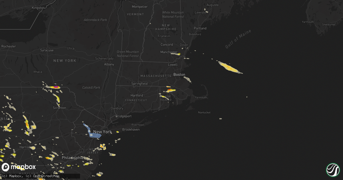
Hail Map on June 29, 2019
Get this storm
June 29 map
$229
one time, instant access
Download today. No call, no setup
Keep the $229
Bought the map and want the full workflow? Apply the entire $229 to a subscription within 7 days. None of it is wasted.
Every map, not just this one
This buys you this map. Subscription and you get every map we run, in the markets you choose from a few cities to whole states to nationwide. Plus real-time alerts the moment a storm fires.
Contact data
Name, contact info, occupancy, even credit band for addresses in the footprint. You go from where it hit to who to call.
Become the source they trust
Unlimited branding weather history reports on demand. You already have the documented answer ready for the property owner, and you are the one who showed up with it.
Property data and RoofTrace estimates
Pull up any address you have got, its value and the exact code rules for that jurisdiction, straight from One Click Code. Then RoofTrace estimates the squares, pitch, and roof value, priced the way you price.
States Impacted by Hail Map on June 29, 2019
- Minnesota
- North Dakota
- New Jersey
- Oklahoma
- Texas
- Delaware
- Maryland
- Pennsylvania
- West Virginia
- Montana
- South Dakota
- Wisconsin
- New York
- Rhode Island
- Massachusetts
- Nebraska
- Illinois
- Virginia
- Ohio
- Wyoming
- Alabama
- Connecticut
- Florida
- Colorado
- Arkansas
- New Hampshire
- Georgia
- Mississippi
- Indiana
- Iowa
- Oregon
- Maine
- Kentucky
- Tennessee
- Louisiana
Storm reports
Mississippi
| Date | Description |
|---|---|
| 06/29/20195:50 PM CDT | Aproximately 12 utility poles down near highway 51 and stateline rd on west side of southaven. |
Vermont
| Date | Description |
|---|---|
| 06/29/20196:45 PM CDT | Trees down |
| 06/29/20196:10 PM CDT | Trees down |
| 06/29/20196:03 PM CDT | Trees down |
| 06/29/20195:55 PM CDT | Trees down |
| 06/29/20195:09 AM CDT | At 1008 PM EDT, a severe thunderstorm was located over Goshen, moving southeast at 20 mph. HAZARD...60 mph wind gusts and quarter size hail. SOURCE...Radar indicated. IMPACT...Minor hail damage to vehicles is possible. Expect wind damage to trees and powerlines. Locations impacted include... Woodstock, Barnard, Hancock, Killington, Ripton, Bethel, Stockbridge, Rochester, Chittenden, Bridgewater, Leicester, Pittsfield, Goshen, Royalton, Pomfret, Salisbury, Sharon, Brandon, Plymouth and Mendon. |
| 06/29/20193:20 AM CDT | At 820 PM EDT, a severe thunderstorm was located over East Fairfield, moving southeast at 25 mph. HAZARD...60 mph wind gusts and quarter size hail. SOURCE...Radar indicated. IMPACT...Minor hail damage to vehicles is possible. Expect wind damage to trees and powerlines. Locations impacted include... Waterville, Eden, Bakersfield, Albany, Johnson, Hyde Park, Wolcott, Albany Village, Lowell, Belvidere Center, Craftsbury, Fairfield, Belvidere, Johnson Village, Sheldon, Enosburg, Montgomery, Fletcher, Hardwick and Irasburg. |
| 06/29/20193:15 AM CDT | At 815 PM EDT, a severe thunderstorm was located over Brainardsville, moving east at 45 mph. HAZARD...60 mph wind gusts and quarter size hail. SOURCE...Radar indicated. IMPACT...Minor hail damage to vehicles is possible. Expect wind damage to trees and powerlines. Locations impacted include... Essex Junction, Plattsburgh, Plattsburgh International Airport, Burlington, Beekmantown, Schuyler Falls, Chazy, Mooers, Altona, Champlain, Burke, Colchester, Essex Junction Village, Georgia, Grand Isle, St. Albans Town, South Alburgh, Alburgh, Alburgh Dunes State Park and North Hero. |
| 06/29/20193:07 AM CDT | At 806 PM EDT, a severe thunderstorm was located over Warren, moving southeast at 20 mph. HAZARD...60 mph wind gusts and quarter size hail. SOURCE...Radar indicated. IMPACT...Minor hail damage to vehicles is possible. Expect wind damage to trees and powerlines. Locations impacted include... Braintree Hill, Chelsea, Bethel, Lincoln, Randolph, Waitsfield, Fayston, Granville, Tunbridge, Warren, Northfield, Roxbury, Braintree, Royalton, Brookfield, Buels Gore, Barnard, Rochester, Vershire and Strafford. |
| 06/29/20192:27 AM CDT | At 726 PM EDT, a severe thunderstorm was located over Essex, moving southeast at 30 mph. HAZARD...60 mph wind gusts and quarter size hail. SOURCE...Radar indicated. IMPACT...Minor hail damage to vehicles is possible. Expect wind damage to trees and powerlines. Locations impacted include... Essex Junction, Barre, Montpelier, Calais, Stowe, Waterbury Village, East Montpelier, Westford, Berlin, Essex Junction Village, Worcester, Middlesex, Bolton, Underhill, Jericho, Essex, Jericho Village, Barre City, Waterbury and Underhill State Park. |
| 06/29/20191:41 AM CDT | At 641 PM EDT, a severe thunderstorm was located over Newport Center, moving southeast at 25 mph. HAZARD...60 mph wind gusts and quarter size hail. SOURCE...Radar indicated. IMPACT...Minor hail damage to vehicles is possible. Expect wind damage to trees and powerlines. Locations impacted include... Newport City, Island Pond, Lyndon, Orleans, Derby Center, Charleston, Newport Town, Jay In Franklin County, Westmore, Orleans Village, Brownington, Burke, Sutton, Coventry, Barton, Troy, Newark, Newark Hollow, Brownington Village and West Burke Village. |
| 06/29/20191:38 AM CDT | At 637 PM EDT, severe thunderstorms were located along a line extending from 27 miles north of Dixville to near Pittsburg to 11 miles northwest of Colebrook, moving southeast at 45 mph. HAZARD...60 mph wind gusts and quarter size hail. SOURCE...Radar indicated. IMPACT...Hail damage to vehicles is expected. Expect wind damage to roofs, siding, and trees. Locations impacted include... Berlin, Lancaster, Colebrook, Errol, Pittsburg, Stratford, Dixville, Columbia, Dummer, Clarksville, Milan, Stark, Wentworth Location, Northumberland and Stewartstown.This also includes... Umbagog Lake State Park, First Connecticut Lake, Kilkenny RidgeTrail, Pontook Reservoir, and Dixville Notch State Park. |
| 06/28/20197:08 PM CDT | Multiple trees down |
| 06/28/20197:06 PM CDT | Trees down |
Maryland
| Date | Description |
|---|---|
| 06/29/20194:45 PM CDT | Mddot gauge. |
| 06/29/20194:40 PM CDT | Trees down in the owings area. |
| 06/29/20194:00 PM CDT | A few tree limbs snapped and fell on power lines in the riverdale area. |
| 06/29/20193:55 PM CDT | A few tree limbs snapped and landed on power lines in the laurel area. |
| 06/29/20193:47 PM CDT | Half a dozen calls for trees down |
| 06/29/20193:45 PM CDT | Multiple trees down... Roof shingles and siding torn off houses... Damage to river docks near 322 river road. |
| 06/29/20193:45 PM CDT | Half a dozen calls for trees down |
| 06/29/20193:40 PM CDT | Tree down on bucks haven lane near bucks haven court. |
| 06/29/20193:37 PM CDT | Tree down on bucks haven lane near bucks haven court. |
| 06/29/20193:33 PM CDT | Large tree down near the intersection of race road and furnace road. |
| 06/29/20193:30 PM CDT | Trees down in the area. Time estimated from radar. |
| 06/29/20193:28 PM CDT | Several trees down along cayots corner road between md 213 and st augustine road. Time estimated from radar. |
| 06/29/20193:18 PM CDT | Tree down on annapolis rock road between hipsley mill road and the montgomery county line. |
| 06/29/20193:12 PM CDT | Several pictures of trees down around damascus... Md. |
| 06/29/20193:10 PM CDT | Several pictures of trees down around damascus... Md. |
| 06/29/20193:02 PM CDT | Social media photo of large tree blown down across blue ball road near wheatley road. More trees reported down in the area. Time estimated from radar. |
| 06/29/20192:52 PM CDT | Tree down on a car in the 3200 block of us-1 conowingo road. |
| 06/29/20192:52 PM CDT | Tree down on us-1 conowingo road near forge hill road... Blocking all lanes. |
| 06/29/20192:51 PM CDT | Thunderstorm outflow resulted in a downed tree and wires on conowingo road. Time estimated from radar. |
| 06/29/20192:40 PM CDT | Trees down near md 402 and central village dr |
| 06/29/20192:39 PM CDT | A local report indicates 1.00 inch wind near 4 N DARES BEACH |
| 06/29/20192:25 PM CDT | Tree down near the intersection of chapel point road and old warehouse road. Tree down in the 9700 block of poorhouse road. |
| 06/29/20192:08 PM CDT | Multiple trees down in the dunkirk area. |
| 06/29/20191:55 PM CDT | Several downed trees and limbs along state highway 310 south of chesapeake city. Time estimated from radar. |
| 06/29/20191:51 PM CDT | Downed trees resulted in property damage on woodstock farm lane. Time estimated from radar. |
| 06/29/20191:23 PM CDT | Branch down in the clinton area. |
| 06/29/20196:40 AM CDT | At 1139 PM EDT, severe thunderstorms were located along a line extending from Fallston to Rosedale, moving east at 35 mph. HAZARD...60 mph wind gusts. SOURCE...Radar indicated. IMPACT...Damaging winds will cause some trees and large branches to fall. This could injure those outdoors, as well as damage homes and vehicles. Roadways may become blocked by downed trees. Localized power outages are possible. Unsecured light objects may become projectiles. Locations impacted include... Middle River, Aberdeen, Havre De Grace, Aberdeen Proving Ground, Back River, Dundalk, Bel Air South, Essex, Bel Air North, Carney, Perry Hall, Rosedale, Rossville, White Marsh, Fallston, Bowleys Quarters, Riverside, Kingsville, Pleasant Hills and Perryman. |
| 06/29/20195:47 AM CDT | At 1047 PM EDT, a severe thunderstorm was located over Westminster, moving east at 35 mph. HAZARD...60 mph wind gusts and quarter size hail. SOURCE...Radar indicated. IMPACT...Damaging winds will cause some trees and large branches to fall. This could injure those outdoors, as well as damage homes and vehicles. Roadways may become blocked by downed trees. Localized power outages are possible. Unsecured light objects may become projectiles. Locations impacted include... Pikesville, Cockeysville, Westminster, Towson, Owings Mills, Reisterstown, Mays Chapel, Timonium, Hampstead, Hampton, Manchester, Lutherville-Timonium, Lutherville, New Windsor, Finksburg, Carrollton, Upperco, Riderwood, Brooklandville and Uniontown. |
| 06/29/20195:25 AM CDT | At 1025 PM EDT, severe thunderstorms were located along a line extending from 6 miles north of Boyds to Round Hill, moving southeast at 30 mph. HAZARD...60 mph wind gusts. SOURCE...Radar indicated. IMPACT...Damaging winds will cause some trees and large branches to fall. This could injure those outdoors, as well as damage homes and vehicles. Roadways may become blocked by downed trees. Localized power outages are possible. Unsecured light objects may become projectiles. Locations impacted include... Germantown, Gaithersburg, Leesburg, South Riding, Damascus, Broadlands, Lansdowne, Lowes Island, Brambleton, Poolesville, Dulles International Airport, Ashburn, Montgomery Village, Sterling, North Potomac, Chantilly, Redland, Countryside, Purcellville and Round Hill. |
| 06/29/20195:18 AM CDT | At 1018 PM EDT, a severe thunderstorm was located 9 miles south of Farmington, or 14 miles north of Kingwood, moving southeast at 35 mph. HAZARD...Wind gusts to 60 mph. SOURCE...Radar. IMPACT...Expect damage to trees and power lines, resulting in some power outages. Locations impacted include... Mountain Lake Park... Oakland... Terra Alta... Bittinger... Loch Lynn Heights... Friendsville... Deer Park... Accident... Markleysburg... Brandonville... Bruceton Mills... Valley Point... |
| 06/29/20193:44 AM CDT | At 843 PM EDT, a severe thunderstorm was located over Saint Charles, or near Waldorf, moving east at 25 mph. HAZARD...60 mph wind gusts. SOURCE...Radar indicated. IMPACT...Damaging winds will cause some trees and large branches to fall. This could injure those outdoors, as well as damage homes and vehicles. Roadways may become blocked by downed trees. Localized power outages are possible. Unsecured light objects may become projectiles. Locations impacted include... Waldorf, La Plata, Saint Charles, Accokeek, Bryans Road, Hughesville, Charlotte Hall, Aquasco, Bryantown, Pomfret, Dentsville and White Plains. |
| 06/29/20193:33 AM CDT | At 833 PM EDT, a severe thunderstorm was located near Hallowing Point, moving east at 25 mph. HAZARD...60 mph wind gusts. SOURCE...Radar indicated. IMPACT...Damaging winds will cause some trees and large branches to fall. This could injure those outdoors, as well as damage homes and vehicles. Roadways may become blocked by downed trees. Localized power outages are possible. Unsecured light objects may become projectiles. Locations impacted include... Chesapeake Ranch Estates, Prince Frederick, Sheridan Point, Flag Harbor, Calvert Cliffs, Lusby, Saint Leonard, Hughesville, Long Beach, Aquasco, Calvert Beach, Benedict, Eagle Harbor, Barstow and Port Republic. |
| 06/29/20193:19 AM CDT | At 819 PM EDT, severe thunderstorms were located along a line extending from 6 miles southwest of Clearville to near Lake Gordon, moving southeast at 30 mph. HAZARD...60 mph wind gusts. SOURCE...Radar indicated. IMPACT...Damaging winds will cause some trees and large branches to fall. This could injure those outdoors, as well as damage homes and vehicles. Roadways may become blocked by downed trees. Localized power outages are possible. Unsecured light objects may become projectiles. Locations impacted include... Hancock, Paw Paw, Greenwood, Berkeley Springs, Great Cacapon, Flintstone, Pecktonville, Big Pool, Little Orleans, Johnsons Mill, Valley View, Spohrs Crossroads, Fishers Bridge, Pumpkin Center, Oakland, Rock Gap, Smith Crossroads, Unger, New Hope and Shady Grove. |
| 06/29/20192:59 AM CDT | At 759 PM EDT, a severe thunderstorm was located near Marlton, or 7 miles southeast of Clinton, moving east at 25 mph. HAZARD...60 mph wind gusts. SOURCE...Radar indicated. IMPACT...Damaging winds will cause some trees and large branches to fall. This could injure those outdoors, as well as damage homes and vehicles. Roadways may become blocked by downed trees. Localized power outages are possible. Unsecured light objects may become projectiles. Locations impacted include... Clinton, Fort Washington, Chesapeake Beach, Prince Frederick, Breezy Point, Andrews Air Force Base, Camp Springs, Oxon Hill, Rosaryville, Friendly, Marlton, Temple Hills, Marlow Heights, Dunkirk, Accokeek, Brandywine, Huntingtown, Owings, Baden and Aquasco. |
| 06/29/201912:11 AM CDT | At 510 PM EDT, a severe thunderstorm was located near Quantico, moving southeast at 20 mph. HAZARD...60 mph wind gusts and quarter size hail. SOURCE...Radar indicated. IMPACT...Damaging winds will cause some trees and large branches to fall. This could injure those outdoors, as well as damage homes and vehicles. Roadways may become blocked by downed trees. Localized power outages are possible. Unsecured light objects may become projectiles. Locations impacted include... Waldorf, La Plata, Dahlgren, Port Tobacco River, Popes Creek, Saint Charles, Wicomico, Bryans Road, Hughesville, Potomac Heights, Bryantown, Pomfret, Port Tobacco Village, Ironsides, Bel Alton, Pisgah, Faulkner, Berthaville, Marbury and Dentsville. |
| 06/29/201912:05 AM CDT | At 505 PM EDT, a severe thunderstorm was located over Kettering, or near Bowie, moving southeast at 25 mph. HAZARD...60 mph wind gusts and quarter size hail. SOURCE...Radar indicated. IMPACT...Damaging winds will cause some trees and large branches to fall. This could injure those outdoors, as well as damage homes and vehicles. Roadways may become blocked by downed trees. Localized power outages are possible. Unsecured light objects may become projectiles. Locations impacted include... Bowie, Annapolis, Crofton, Forestville, Largo, Mayo, Shady Side, Chesapeake Beach, Deale, Naval Academy, Upper Marlboro, Severn River, South River, Breezy Point, Rhode River, Fedex Field, Odenton, Arnold, Parole and Kettering. |
| 06/28/201911:58 PM CDT | At 457 PM EDT, a severe thunderstorm was located near Gibson Island, moving southeast at 30 mph. HAZARD...60 mph wind gusts and half dollar size hail. SOURCE...Radar indicated. IMPACT...Minor damage to vehicles is possible. Wind damage to roofs, siding, trees, and power lines is possible. Locations impacted include... Easton, Centerville, Centreville, Rock Hall, Queen Anne, Grasonville, Starr, Stevensville, Skipton, Copperville, Chester, Overton, Wye Mills, Cordova, Carville, Hope, Queenstown, Stevensville South and Dominion. |
| 06/28/201911:52 PM CDT | At 452 PM EDT, a severe thunderstorm was located over Hazlettville, or near Dover, moving east at 15 mph. HAZARD...60 mph wind gusts and quarter size hail. SOURCE...Radar indicated. IMPACT...Minor damage to vehicles is possible. Wind damage to roofs, siding, trees, and power lines is possible. Locations impacted include... Dover, Milford, Camden, Bowers, Woodside, Viola, Rising Sun-Lebanon, Rising Sun, Hazlettville, Dover Base Housing, Big Stone Beach, Sandtown, Wyoming, Felton, Frederica, Magnolia, Marydel, Rodney Village, Kent Acres and Riverview. |
| 06/28/201911:45 PM CDT | At 445 PM EDT, a severe thunderstorm was located near Dale City, moving southeast at 20 mph. HAZARD...60 mph wind gusts and quarter size hail. SOURCE...Radar indicated. IMPACT...Damaging winds will cause some trees and large branches to fall. This could injure those outdoors, as well as damage homes and vehicles. Roadways may become blocked by downed trees. Localized power outages are possible. Unsecured light objects may become projectiles. Locations impacted include... Dale City, Fort Belvoir, Woodbridge, Quantico, Lake Ridge, Linton Hall, Montclair, Lorton, Triangle, Dumfries, Manassas, Cherry Hill, Independent Hill, Mason Neck, Nokesville, Occoquan and Aden. |
| 06/28/201911:43 PM CDT | At 443 PM EDT, a severe thunderstorm was located near Berkeley Springs, or 9 miles south of Hancock, moving southeast at 25 mph. HAZARD...60 mph wind gusts. SOURCE...Radar indicated. IMPACT...Damaging winds will cause some trees and large branches to fall. This could injure those outdoors, as well as damage homes and vehicles. Roadways may become blocked by downed trees. Localized power outages are possible. Unsecured light objects may become projectiles. Locations impacted include... Martinsburg, Inwood, Berkeley, Falling Waters, Hedgesville, Winebrenners Cross, Tomahawk, Johnsontown, Shanghai, Vanville, Arden, Jones Springs and Martinsburg Airport. |
| 06/28/201911:38 PM CDT | At 437 PM EDT, severe thunderstorms were located along a line extending from Port Penn to Warwick, moving southeast at 30 mph. HAZARD...60 mph wind gusts and quarter size hail. SOURCE...Radar indicated. IMPACT...Minor damage to vehicles is possible. Wind damage to roofs, siding, trees, and power lines is possible. Locations impacted include... Dover, Middletown, Smyrna, Camden, Clayton, Delaware City, Cheswold, Cecilton, Hartly, Warwick, Bohemias Mills, Hazlettville, Port Penn, Delaney Corner, Dover Base Housing, Dover Speedway, Saint Georges, Sassafras, Mount Pleasant and Green Spring. |
| 06/28/201911:34 PM CDT | At 434 PM EDT, a severe thunderstorm was located over Fort Meade, or over Severn, moving southeast at 20 mph. HAZARD...60 mph wind gusts. SOURCE...Radar indicated. IMPACT...Damaging winds will cause some trees and large branches to fall. This could injure those outdoors, as well as damage homes and vehicles. Roadways may become blocked by downed trees. Localized power outages are possible. Unsecured light objects may become projectiles. Locations impacted include... Columbia, Severn, Annapolis, Crofton, Elkridge, Riviera Beach, Mayo, Naval Academy, Baltimore-Washington Airport, Severn River, South River, Gibson Island, Bodkin Point, Sillery Bay, Pinehurst, Glen Burnie, Ellicott City, Severna Park, Odenton and Laurel. |
| 06/28/201911:24 PM CDT | At 424 PM EDT, a severe thunderstorm was located 7 miles southwest of Sykesville, or 8 miles east of Damascus, moving east at 20 mph. HAZARD...60 mph wind gusts. SOURCE...Radar indicated. IMPACT...Damaging winds will cause some trees and large branches to fall. This could injure those outdoors, as well as damage homes and vehicles. Roadways may become blocked by downed trees. Localized power outages are possible. Unsecured light objects may become projectiles. Locations impacted include... Columbia, Ellicott City, Catonsville, Woodlawn, Randallstown, Milford Mill, Savage-guilford, Scaggsville, Ilchester, Burtonsville, Savage, Fulton, Highland, Clarksville, West Friendship, Dayton, Woodstock, Granite, Roxbury Mills and Glenelg. |
| 06/28/201911:19 PM CDT | At 419 PM EDT, a severe thunderstorm was located over Severn River, moving east at 20 mph. HAZARD...60 mph wind gusts. SOURCE...Radar indicated. IMPACT...Damaging winds will cause some trees and large branches to fall. This could injure those outdoors, as well as damage homes and vehicles. Roadways may become blocked by downed trees. Localized power outages are possible. Unsecured light objects may become projectiles. Locations impacted include... Annapolis, Mayo, Naval Academy, Severn River, South River, Severna Park, Arnold, Lake Shore, Parole, Edgewater, Cape St. Claire, Highland Beach, Hillsmere Shores, Sherwood Forest, Belvedere Heights, Navy-Marine Corps Stadium, Eastport and Bay Ridge. |
| 06/28/201911:14 PM CDT | At 414 PM EDT, a severe thunderstorm was located over Chestertown, or 10 miles north of Centerville, moving southeast at 25 mph. HAZARD...60 mph wind gusts and quarter size hail. SOURCE...Radar indicated. IMPACT...Minor damage to vehicles is possible. Wind damage to roofs, siding, trees, and power lines is possible. Locations impacted include... Chestertown, Church Hill, Sudlersville, Starkey Corner, Old Town, Langford, Templeville, Barclay and Kingstown. |
| 06/28/201911:13 PM CDT | At 413 PM EDT, a severe thunderstorm was located over Woodlawn, or near Pikesville, moving east at 20 mph. HAZARD...60 mph wind gusts. SOURCE...Radar indicated. IMPACT...Damaging winds will cause some trees and large branches to fall. This could injure those outdoors, as well as damage homes and vehicles. Roadways may become blocked by downed trees. Localized power outages are possible. Unsecured light objects may become projectiles. Locations impacted include... Baltimore, Pikesville, Middle River, Riviera Beach, Baltimore-Washington Airport, North Point State Park, Sparrows Point, Back River, Millers Island, Glen Burnie, Ellicott City, Dundalk, Towson, Catonsville, Essex, Woodlawn, Randallstown, Parkville, Milford Mill and Perry Hall. |
| 06/28/201911:11 PM CDT | At 410 PM EDT, a severe thunderstorm was located over Inglesmith, or 11 miles west of Hancock, moving southeast at 25 mph. HAZARD...60 mph wind gusts and quarter size hail. SOURCE...Radar indicated. IMPACT...Damaging winds will cause some trees and large branches to fall. This could injure those outdoors, as well as damage homes and vehicles. Roadways may become blocked by downed trees. Localized power outages are possible. Unsecured light objects may become projectiles. Locations impacted include... Hancock, Berkeley Springs, Great Cacapon, Pecktonville, Big Pool, Little Orleans, Johnsons Mill, Cherry Run, Lineburg, Valley View, Spohrs Crossroads, Spruce Pine Hollow, Rock Gap, Stotlers Crossroads, Highland Ridge, Forest Park, Bellegrove, Smith Crossroads, Berryville and New Hope. |
| 06/28/201911:08 PM CDT | At 408 PM EDT, a severe thunderstorm was located over Damascus, moving southeast at 20 mph. HAZARD...60 mph wind gusts and quarter size hail. SOURCE...Radar indicated. IMPACT...Damaging winds will cause some trees and large branches to fall. This could injure those outdoors, as well as damage homes and vehicles. Roadways may become blocked by downed trees. Localized power outages are possible. Unsecured light objects may become projectiles. Locations impacted include... Germantown, Rockville, Gaithersburg, Olney, Damascus, Aspen Hill, Montgomery Village, North Potomac, Redland, Rossmoor, Scaggsville, Cloverly, Clarksburg, Burtonsville, Derwood, Fulton, Spencerville, Highland, Washington Grove and Laytonsville. |
| 06/28/201911:05 PM CDT | At 405 PM EDT, a severe thunderstorm was located over Hybla Valley, or over Groveton, moving southeast at 15 mph. HAZARD...70 mph wind gusts and quarter size hail. SOURCE...Radar indicated. IMPACT...Damaging winds will cause some trees and large branches to fall. This could injure those outdoors, as well as damage homes and vehicles. Roadways may become blocked by downed trees. Localized power outages are possible. Unsecured light objects may become projectiles. Locations impacted include... Alexandria, Waldorf, Annandale, Clinton, Springfield, Fort Washington, Fort Hunt, Groveton, Huntington, La Plata, Fort Belvoir, National Harbor, Lincolnia, Camp Springs, Lorton, Franconia, Oxon Hill, Hybla Valley, Newington and Rosaryville. |
| 06/28/201910:59 PM CDT | At 359 PM EDT, severe thunderstorms were located along a line extending from near Kennett Square to Glen Westover to Farmington, moving southeast at 35 mph. HAZARD...70 mph wind gusts and quarter size hail. SOURCE...Radar indicated. IMPACT...Minor damage to vehicles is possible. Expect considerable tree damage. Wind damage is also likely to mobile homes, roofs, and outbuildings. Locations impacted include... Wilmington, Newark, Middletown, Elkton, Calvert, Chester, Pennsville, Carneys Point, Elsmere, Kennett Square, New Castle, Penns Grove, Salem, Oxford, North East, Woodstown, Alloway, West Grove, Rising Sun and Quinton. |
| 06/28/201910:49 PM CDT | At 349 PM EDT, a severe thunderstorm was located 8 miles northeast of Lake Gordon, moving southeast at 30 mph. HAZARD...60 mph wind gusts and quarter size hail. SOURCE...Radar indicated. IMPACT...Hail damage to vehicles is expected. Expect wind damage to trees, roofs, and siding. Locations impacted include... Warfordsburg, Barnes Gap, Inglesmith, Lake Gordon and Rainsburg. This includes Interstate 70 near mile marker 162...and from milemarkers 167 to 170. |
| 06/28/201910:48 PM CDT | At 348 PM EDT, severe thunderstorms were located along a line extending from near Delta to Bel Air North, moving east at 30 mph. HAZARD...60 mph wind gusts. SOURCE...Radar indicated. IMPACT...Damaging winds will cause some trees and large branches to fall. This could injure those outdoors, as well as damage homes and vehicles. Roadways may become blocked by downed trees. Localized power outages are possible. Unsecured light objects may become projectiles. Locations impacted include... Aberdeen, Havre De Grace, Aberdeen Proving Ground, Bel Air South, Bel Air North, Fallston, Riverside, Pleasant Hills, Perryman, Edgewood, Darlington, Benson, Churchville, Carsins, Scarboro, Forest Hill, Bynum, Harford Furnace, Abingdon and Hickory. |
| 06/28/201910:47 PM CDT | Golfball size hail with damage to vehicles. |
| 06/28/201910:33 PM CDT | At 333 PM EDT, a severe thunderstorm was located 7 miles southeast of Taylors Island, moving southeast at 20 mph. HAZARD...60 mph wind gusts. SOURCE...Radar indicated. IMPACT...Expect damage to trees and powerlines. Locations impacted include... Church Creek, Madison, Woolford, Andrews, Elliott, Crocheron, Bucktown and Wingate. |
| 06/28/201910:27 PM CDT | At 327 PM EDT, a severe thunderstorm was located near Prince Frederick, moving southeast at 20 mph. HAZARD...60 mph wind gusts and quarter size hail. SOURCE...Radar indicated. IMPACT...Damaging winds will cause some trees and large branches to fall. This could injure those outdoors, as well as damage homes and vehicles. Roadways may become blocked by downed trees. Localized power outages are possible. Unsecured light objects may become projectiles. Locations impacted include... Chesapeake Ranch Estates, Prince Frederick, Breezy Point, Flag Harbor, Calvert Cliffs, Lusby, Saint Leonard, Huntingtown, Long Beach, Calvert Beach, Port Republic and Dares Beach. |
| 06/28/201910:27 PM CDT | At 326 PM EDT, severe thunderstorms were located along a line extending from near Gap to near Safe Harbor to near Stewartstown, moving east at 25 mph. HAZARD...Golf ball size hail and 70 mph wind gusts. SOURCE...Radar indicated. IMPACT...People and animals outdoors will be injured. Expect hail damage to roofs, siding, windows, and vehicles. Expect considerable tree damage. Wind damage is also likely to mobile homes, roofs, and outbuildings. Locations impacted include... Havre De Grace, Calvert, Kennett Square, Oxford, Parkesburg, North East, West Grove, Rising Sun, Homeville, Glen Roy, Zion, Blake, Cochranville, West Nottingham, Octoraro, Mount Vernon, Fair Hill, Glen Westover, Bay View and Lombard. |
| 06/28/201910:15 PM CDT | At 315 PM EDT, severe thunderstorms were located along a line extending from Rothsville to near Strasburg to near Brogue, moving east at 20 mph. HAZARD...60 mph wind gusts and quarter size hail. SOURCE...Radar indicated. IMPACT...Hail damage to vehicles is expected. Expect wind damage to trees, roofs, and siding. Locations impacted include... Lancaster, Ephrata, Columbia, Lititz, Millersville, Willow Street, Mount Joy, Red Lion, New Holland, Manheim, East Petersburg, Dallastown, Akron, Leola, Stonybrook-Wilshire, Paradise, Salunga-Landisville, Denver, Reamstown and Rothsville.This includes The Pennsylvania Turnpike from mile markers 275 to 295. |
| 06/28/20199:49 PM CDT | Over a dozen trees down along savage river road. |
| 06/28/20199:47 PM CDT | At 246 PM EDT, a severe thunderstorm was located over Cayots, or near Elkton, and moving east at 5 mph. HAZARD...60 mph wind gusts and quarter size hail. SOURCE...Radar indicated. IMPACT...Minor damage to vehicles is possible. Wind damage to roofs, siding, trees, and power lines is possible. Locations impacted include... Middletown, Warwick, Mount Pleasant, Cayots, Hollywood Beach, Bohemias Mills and Chesapeake City. |
| 06/28/20199:37 PM CDT | At 237 PM EDT, a severe thunderstorm was located over Rosaryville, or near Clinton, moving southeast at 20 mph. HAZARD...60 mph wind gusts and quarter size hail. SOURCE...Radar indicated. IMPACT...Damaging winds will cause some trees and large branches to fall. This could injure those outdoors, as well as damage homes and vehicles. Roadways may become blocked by downed trees. Localized power outages are possible. Unsecured light objects may become projectiles. Locations impacted include... Clinton, Chesapeake Beach, Prince Frederick, Breezy Point, Andrews Air Force Base, Rosaryville, Marlton, Dunkirk, Accokeek, Brandywine, Huntingtown, Owings, Baden, Aquasco, Calvert Beach, Friendship, Lower Marlboro, Port Republic, Sunderland and Cheltenham. |
| 06/28/20199:36 PM CDT | Large tree limbs down in the taneytown area. |
| 06/28/20199:28 PM CDT | At 228 PM EDT, a severe thunderstorm was located over Fredericksburg, moving southeast at 20 mph. HAZARD...60 mph wind gusts and quarter size hail. SOURCE...Radar indicated. IMPACT...Damaging winds will cause some trees and large branches to fall. This could injure those outdoors, as well as damage homes and vehicles. Roadways may become blocked by downed trees. Localized power outages are possible. Unsecured light objects may become projectiles. Locations impacted include... Stafford, Fredericksburg, King George, Fairview Beach, Aquia Creek, Massaponax, Spotsylvania, Falmouth, Passapatanzy, Stones Corner, Ramoth, Thornburg, White Oak, Sealston, Jersey, Dogue, Leeland, Rollins Fork, Arkendale and Spring Valley. |
| 06/28/20199:26 PM CDT | At 225 PM EDT, a severe thunderstorm was located over Fort Loudon, moving southeast at 35 mph. HAZARD...60 mph wind gusts and quarter size hail. SOURCE...Radar indicated. IMPACT...Hail damage to vehicles is expected. Expect wind damage to trees, roofs, and siding. Locations impacted include... Waynesboro, Greencastle, Wayne Heights, Mercersburg, McConnellsburg, Rouzerville, Marion, Fort Loudon, Big Cove Tannery, Claylick, State Line, Quincy, Williamson and Upton.This includes Interstate 81 from mile markers 0 to 9. |
| 06/28/20199:20 PM CDT | At 219 PM EDT, a severe thunderstorm was located near Dahlgren, moving southeast at 15 mph. HAZARD...60 mph wind gusts and quarter size hail. SOURCE...Radar indicated. IMPACT...Damaging winds will cause some trees and large branches to fall. This could injure those outdoors, as well as damage homes and vehicles. Roadways may become blocked by downed trees. Localized power outages are possible. Unsecured light objects may become projectiles. Locations impacted include... King George, Leonardtown, Dahlgren, Fairview Beach, Saint Clements Bay, Popes Creek, Wicomico, Cobb Island, Rock Point, Bushwood, Clements, Issue, Tompkinsville, Weedonville, Abell, Chaptico, Ninde, Bel Alton, Swan Point and Avenue. |
| 06/28/20199:19 PM CDT | At 219 PM EDT, a severe thunderstorm was located near Pine Grove Furnace, moving southeast at 45 mph. HAZARD...60 mph wind gusts and half dollar size hail. SOURCE...Radar indicated. IMPACT...Hail damage to vehicles is expected. Expect wind damage to trees, roofs, and siding. Locations impacted include... Hanover, Gettysburg, Parkville, Hampton, Codorus, McSherrystown, Lake Meade, Spring Grove, Glen Rock, Pennville, Bonneauville, New Oxford, East Berlin, Lake Heritage, Cashtown, Aspers, Orrtanna, Pine Grove Furnace, York Airport and Biglerville.This includes Interstate 83 from mile markers 6 to 7. |
| 06/28/20198:40 PM CDT | Tree down on mapleville rd. South of national pike. |
| 06/28/20198:26 PM CDT | At 126 PM EDT, a severe thunderstorm was located near Hollywood Beach, or 8 miles east of Aberdeen Proving Ground, moving southeast at 15 mph. HAZARD...60 mph wind gusts and quarter size hail. SOURCE...Radar indicated. IMPACT...Minor damage to vehicles is possible. Wind damage to roofs, siding, trees, and power lines is possible. Locations impacted include... Cecilton, Warwick, Cayots, Crumpton, Bohemias Mills, Kennedyville, Sassafras and Galena. |
| 06/28/20198:05 PM CDT | Tree down near intersection of e. Industrial blvd. And winston st. |
| 06/28/20197:49 PM CDT | Trees down in the prince frederick area. |
| 06/28/20197:32 PM CDT | Quarter size hail at chesapeake beach |
| 06/28/20197:30 PM CDT | Numerous trees down in the north beach area. |
| 06/28/20197:29 PM CDT | Quarter size hail at chesapeake beach |
| 06/28/20197:27 PM CDT | A local report indicates 1.00 inch wind near 1 SSE MOUNT HARMONY |
| 06/28/20197:26 PM CDT | A local report indicates 1.00 inch wind near 1 SSE MOUNT HARMONY |
| 06/28/20197:23 PM CDT | Multiple trees down in the owings area. |
| 06/28/20197:15 PM CDT | Multiple trees down in the dunkirk area. |
Minnesota
| Date | Description |
|---|---|
| 06/29/20191:13 PM CDT | Several large branches broken down in farmsteads across northern humboldt township. Time estimated based on nearby wind sensor reports. |
| 06/29/20191:09 PM CDT | Winds persisting at 43 mph gusting to 61 mph at the moorhead airport /kjkl/. |
| 06/29/20191:00 PM CDT | A semi truck and trailer were blown off of highway 10. Time estimated based on radar. |
| 06/29/201912:56 PM CDT | Peak winds measured at the moorhead airport /kjkl/. |
| 06/29/201912:40 PM CDT | Trees snapped in south moorhead. Time estimated based on radar and nearby wind sensor reports. |
| 06/29/20197:50 AM CDT | At 1250 PM CDT, severe thunderstorms were located along a line extending from near Dilworth to Downer to Buffalo River State Park to 7 miles south of Baker, moving east at 35 mph. HAZARD...60 mph wind gusts. SOURCE...Trained weather spotters. IMPACT...Expect damage to roofs, siding, and trees. Severe thunderstorms will be near... Barnesville and Downer around 1255 PM CDT. Buffalo River State Park around 105 PM CDT. Lawndale and Muskoda around 110 PM CDT. Rollag, Hawley and Rothsay around 115 PM CDT. Dale and Cormorant around 125 PM CDT.This includes Interstate 94 in Minnesota between mile markers 8 and41. |
| 06/29/20197:11 AM CDT | At 1210 PM CDT, severe thunderstorms were located along a line extending from near Cummings to near Gardner to near Chaffee, moving east at 35 mph. HAZARD...60 mph wind gusts. SOURCE...Public. IMPACT...Expect damage to roofs, siding, and trees. Severe thunderstorms will be near... Gardner and Argusville around 1215 PM CDT. Caledonia and Brooktree Park around 1220 PM CDT. Georgetown, Shelly and Perley around 1225 PM CDT. Mapleton around 1230 PM CDT. West Fargo around 1235 PM CDT.Other locations impacted by these severe thunderstorms includeCasselton Airport, American Crystal Sugar, Moorhead Airport and WestArgusville.This includes the following highways... Interstate 29 between mile markers 58 and 110. Interstate 94 in North Dakota between mile markers 326 and 352. Interstate 94 in Minnesota between mile markers 1 and 14. |
| 06/29/20196:31 AM CDT | At 1131 PM CDT, severe thunderstorms were located along a line extending from near Thorhult to 8 miles south of Espelie to near Dakota Junction, moving east at 40 mph. HAZARD...60 mph wind gusts and quarter size hail. SOURCE...Radar indicated. IMPACT...Hail damage to vehicles is expected. Expect wind damage to roofs, siding, and trees. Severe thunderstorms will be near... Thorhult, Fourtown and Malcolm around 1135 PM CDT. Goodridge, Upper Red Lake and High Landing around 1150 PM CDT. Espelie around 1155 PM CDT. Ponemah around 1220 AM CDT.Other locations impacted by these severe thunderstorms include ThiefRiver Falls Airport. |
| 06/29/20195:55 AM CDT | At 1055 PM CDT, a severe thunderstorm was located near Middle River, or 21 miles north of Thief River Falls, moving east at 50 mph. HAZARD...60 mph wind gusts and quarter size hail. SOURCE...Radar indicated. IMPACT...Hail damage to vehicles is expected. Expect wind damage to roofs, siding, and trees. This severe thunderstorm will be near... Gatzke around 1120 PM CDT. Torfin around 1125 PM CDT. Casperson around 1130 PM CDT. |
| 06/29/20195:39 AM CDT | At 1039 AM CDT, severe thunderstorms were located along a line extending from Forest River Colony to 6 miles southeast of Logan Center to Hannaford, moving east at 35 mph. HAZARD...60 mph wind gusts and penny size hail. SOURCE...Radar indicated. IMPACT...Expect damage to roofs, siding, and trees. Severe thunderstorms will be near... Forest River Colony, Fordville and Logan Center around 1040 AM CDT. Conway, Inkster and Orr around 1045 AM CDT. Northwood and Kempton around 1050 AM CDT. Forest River, Johnstown and Hatton around 1100 AM CDT. Ardoch and Blabon around 1110 AM CDT.Other locations impacted by these severe thunderstorms include GrandForks Airport.This includes Interstate 29 between mile markers 122 and 165. |
| 06/29/20195:28 AM CDT | At 1028 PM CDT, a severe thunderstorm was located near Stephen, or 23 miles east of Grafton, moving east at 50 mph. HAZARD...Quarter size hail. SOURCE...Radar indicated. IMPACT...Damage to vehicles is expected. This severe thunderstorm will be near... Argyle around 1030 PM CDT. Florian, Englund and Old Mill State Park around 1045 PM CDT. Strandquist around 1055 PM CDT. |
| 06/29/20195:25 AM CDT | Corrects previous tstm wnd dmg report from 3 wnw glory. Large branch fell off of tree and aqua jump flipped over. |
| 06/29/20195:13 AM CDT | A local report indicates 1.00 inch wind near MARCELL |
| 06/29/20194:45 AM CDT | Four birch trees were uprooted. Time estimated by radar. |
| 06/29/20194:45 AM CDT | A tree with a grapefruit-sized trunk snapped about 2 feet from the ground and fell over. Time estimated by radar. |
| 06/29/20194:45 AM CDT | Report relayed via social media. |
| 06/29/20194:25 AM CDT | Large branch fell off of tree and aqua jump flipped over. |
| 06/29/20194:15 AM CDT | Awos station kait aitkin airport. |
| 06/29/20193:54 AM CDT | Tall tree snapped in the middle. Time estimated by radar. |
| 06/29/20193:35 AM CDT | Uprooted tree 12 inches in diameter. Time estimated by radar. |
| 06/29/20193:30 AM CDT | Report and photo of snapped tree posted via social media. Time estimated based on radar. |
| 06/29/20193:18 AM CDT | White pine tree limbs down which were around 6 inches in diameter and 8 to 10 feet long. Time estimated by radar. |
| 06/29/20192:55 AM CDT | Corrects previous tstm wnd dmg report from keewatin. Large tree snapped in half and another tree had a large broken limb land on the roof of a house. Time estimated fro |
| 06/29/20192:42 AM CDT | A local report indicates 1.00 inch wind near 3 N SHEVLIN |
| 06/29/20192:35 AM CDT | Large hail moved across the lake irving from 235 to 245 am cdt. |
| 06/29/20192:28 AM CDT | Two tall trees uprooted and fell on a swing set. Time estimated by radar. |
| 06/29/20192:10 AM CDT | Crops showed wind and hail damage across central windsor township. |
| 06/29/20191:56 AM CDT | Social media image of a medium sized tree snapped. Time based on radar. |
| 06/29/20191:56 AM CDT | Report and photo posted via social media of multiple trees snapped between turtle river and tenstrike areas. Time estimated based on radar. |
| 06/29/201912:58 AM CDT | A few large 2 to 4 inch diameter tree branches broken down as well. |
| 06/28/201911:59 PM CDT | A local report indicates 1.25 inch wind near 1 ENE GOODRIDGE |
| 06/28/201911:35 PM CDT | Several large poplar branches and limbs broken down. Brief power outages. |
| 06/28/201910:56 PM CDT | Some dime to quarter sized hail... Along with strong winds and very heavy rains. |
| 06/28/20198:32 PM CDT | At 131 PM CDT, a severe thunderstorm was located over Portland, or 32 miles southwest of Grand Forks, moving east at 45 mph. HAZARD...Half dollar size hail. SOURCE...Radar indicated. IMPACT...Damage to vehicles is expected. This severe thunderstorm will be near... Cummings around 150 PM CDT. Caledonia around 200 PM CDT. Climax and Nielsville around 205 PM CDT.Other locations impacted by this severe thunderstorm include AmericanCrystal Sugar.This includes Interstate 29 between mile markers 104 and 118. |
| 06/28/20198:25 PM CDT | At 124 PM CDT, severe thunderstorms were located along a line extending from near Felton to near Dale to near Lawndale, moving east at 40 mph. HAZARD...70 mph wind gusts. SOURCE...Trained weather spotters. IMPACT...Expect considerable tree damage. Damage is likely to mobile homes, roofs, and outbuildings. Severe thunderstorms will be near... Dale around 130 PM CDT. Pelican Rapids and Lake Park around 135 PM CDT. Dunvilla around 140 PM CDT. Lake Lida around 145 PM CDT. Westbury, Maplewood State Park and Shoreham around 150 PM CDT. |
New Hampshire
| Date | Description |
|---|---|
| 06/29/20196:26 PM CDT | Trees on wires |
| 06/28/201910:55 PM CDT | Trees down |
| 06/28/201910:55 PM CDT | A local report indicates 1.00 inch wind near 2 NE KINGSTON |
| 06/28/201910:45 PM CDT | Several reports of trees down |
| 06/28/201910:45 PM CDT | Multiple trees down in a straight line between whitter dr and chester rd along sandown rd to include one tree landing on a barn. |
| 06/28/20198:29 PM CDT | Multiple trees and limbs down |
Georgia
| Date | Description |
|---|---|
| 06/29/201911:23 AM CDT | Several lines down near the intersection of rosemont rd and rosemont school rd. |
| 06/29/20197:48 AM CDT | At 1248 PM EDT, a severe thunderstorm was located near Nicklesville, or 9 miles east of Jeffersonville, moving north at 10 mph. HAZARD...60 mph wind gusts and quarter size hail. SOURCE...Radar indicated. IMPACT...Hail damage to vehicles is expected. Expect wind damage to roofs, siding, and trees. Locations impacted include... Irwinton, McIntyre, Toomsboro, Danville, Allentown and Nicklesville. |
| 06/29/20197:21 AM CDT | At 1221 PM EDT, a severe thunderstorm was located over Big Springs, or near LaGrange, moving north at 10 mph. HAZARD...60 mph wind gusts and quarter size hail. SOURCE...Radar indicated. IMPACT...Hail damage to vehicles is expected. Expect wind damage to roofs, siding, and trees. Locations impacted include... LaGrange, Hogansville, Mountville, Hillcrest, Big Springs, Wares Crossroads, Louise, Baughs Crossroads and Smiths Crossroad. |
| 06/28/201911:52 PM CDT | At 452 PM EDT, a severe thunderstorm was located over Baileys Park, or near Hawkinsville, moving northwest at 5 mph. HAZARD...60 mph wind gusts. SOURCE...Radar indicated. IMPACT...Expect damage to roofs, siding, and trees. Locations impacted include... Cochran, Hawkinsville, Paulk, Mobley Crossing, Pulaski State Prison, Porter and Baileys Park. |
| 06/28/201911:31 PM CDT | At 431 PM EDT, a severe thunderstorm was located near Hartford, or near Hawkinsville, and is nearly stationary. HAZARD...60 mph wind gusts. SOURCE...Radar indicated. IMPACT...Expect damage to roofs, siding, and trees. Locations impacted include... Hawkinsville, Hartford and Pulaski State Prison. |
| 06/28/201911:12 PM CDT | At 412 PM EDT, a severe thunderstorm was located over Tippettville, or 13 miles southwest of Hawkinsville, moving west at 5 mph. HAZARD...60 mph wind gusts and penny size hail. SOURCE...Radar indicated. IMPACT...Expect damage to roofs, siding, and trees. Locations impacted include... Pineview, Wallace, Mock Springs, Pleasant View and Tippettville. |
| 06/28/20199:44 PM CDT | At 243 PM EDT, a severe thunderstorm was located over Prattsburg, or 11 miles east of Talbotton, moving northwest at 20 mph. HAZARD...60 mph wind gusts. SOURCE...Radar indicated. IMPACT...Expect damage to roofs, siding, and trees. Locations impacted include... Manchester, Woodland, Sunset Village, Sprewell Bluff State Park, Crest, Pleasant Hill, Sunnyside, Prattsburg, Big Lazer Creek Wma, Wesley Church and Carsonville. |
| 06/28/20198:52 PM CDT | At 152 PM EDT, a severe thunderstorm was located over Atwater, or near Thomaston, moving north at 10 mph. HAZARD...60 mph wind gusts and quarter size hail. SOURCE...Radar indicated. IMPACT...Hail damage to vehicles is expected. Expect wind damage to roofs, siding, and trees. Locations impacted include... Zebulon, Molena, Meansville, Crest, Atwater, Hilltop, Lifsey Springs and Hannahs Mill. |
| 06/28/20198:48 PM CDT | At 148 PM EDT, a severe thunderstorm was located near Franklin, moving north at 10 mph. HAZARD...60 mph wind gusts and quarter size hail. SOURCE...Radar indicated. IMPACT...Hail damage to vehicles is expected. Expect wind damage to roofs, siding, and trees. Locations impacted include... Franklin, Ephesus, Centralhatchee, Frolona, Texas, Glenn and Powers Crossroads. |
Connecticut
| Date | Description |
|---|---|
| 06/29/20196:54 PM CDT | Large branches down off of interstate 95 between exits 17 and 18 with time estimated by radar |
| 06/29/20192:38 AM CDT | At 737 PM EDT, a severe thunderstorm was located over Westport, or over Norwalk, moving southeast at 25 mph. HAZARD...60 mph wind gusts and quarter size hail. SOURCE...Radar indicated. IMPACT...Minor hail damage to vehicles is possible. Expect wind damage to trees and power lines. Locations impacted include... Norwalk, New Canaan, Fairfield, Westport and Wilton. |
| 06/28/20197:12 PM CDT | Tree split with half of the tree down off of minor street with time estimated by radar |
| 06/28/20197:07 PM CDT | 60 mph measured at lighthouse point at 25 ft. |
| 06/28/20197:00 PM CDT | Large branches down on island lane near the west haven and milford border |
South Dakota
| Date | Description |
|---|---|
| 06/29/20194:05 PM CDT | Tornado in progress...largely stationary...but starting to drift southeast |
| 06/29/20193:36 PM CDT | Tornado reported in progress sw of allen |
| 06/28/201910:32 PM CDT | At 331 PM MDT, a severe thunderstorm was located 5 miles southwest of Hisle, or 12 miles north of Martin, moving northeast at 15 mph. HAZARD...60 mph wind gusts and quarter size hail. SOURCE...Radar indicated. IMPACT...Hail damage to vehicles is expected. Expect wind damage to roofs, siding, and trees. Locations impacted include... Hisle and Eagle Nest Butte. |
Delaware
| Date | Description |
|---|---|
| 06/29/20194:14 PM CDT | Pea to quarter size hail fell from 5:14 to 5:22 pm. |
| 06/29/20193:42 PM CDT | Mping report of tree limbs down and property damage from thunderstorm winds at this location. Time estimated from radar. |
| 06/29/20193:40 PM CDT | Several reports of tree damage in the middletown area. Time estimated from radar. |
| 06/29/20193:24 PM CDT | A tin roof was dented from the hail. Time estimated from radar. |
| 06/29/20193:19 PM CDT | Private weather station. |
| 06/29/20193:15 PM CDT | Tree damage and winds estimated to be 60-65 mph. Time estimated from radar. |
| 06/29/20193:13 PM CDT | Large tree limbs down in bear. Time estimated from radar. |
| 06/29/20193:25 AM CDT | At 825 PM EDT, a severe thunderstorm was located over Parkesburg, or 14 miles west of West Chester, moving east at 25 mph. HAZARD...60 mph wind gusts and quarter size hail. SOURCE...Radar indicated. IMPACT...Minor damage to vehicles is possible. Wind damage to roofs, siding, trees, and power lines is possible. Locations impacted include... West Chester, Coatesville, Westtown, Downingtown, Kennett Square, Parkesburg, Cochranville, Marshallton, Hockessin, West Goshen, Atglen, South Coatesville, Avondale, Modena, Thorndale, Toughkenamon and Exton. |
| 06/29/201912:26 AM CDT | At 525 PM EDT, severe thunderstorms were located along a line extending from near Bowers to near Romancoke, moving southeast at 35 mph. HAZARD...70 mph wind gusts and quarter size hail. SOURCE...Radar indicated. IMPACT...Minor damage to vehicles is possible. Expect considerable tree damage. Wind damage is also likely to mobile homes, roofs, and outbuildings. Locations impacted include... Dover, Easton, Georgetown, Centerville, Talbot, Milford, Seaford, Denton, Centreville, Millsboro, Laurel, Harrington, Camden, Lewes, Federalsburg, Milton, Selbyville, Bridgeville, Greensboro and Oakland. |
| 06/28/201911:55 PM CDT | At 455 PM EDT, a severe thunderstorm was located over Church Hill, or 9 miles northeast of Centerville, moving southeast at 25 mph. HAZARD...60 mph wind gusts and quarter size hail. SOURCE...Radar indicated. IMPACT...Minor damage to vehicles is possible. Wind damage to roofs, siding, trees, and power lines is possible. Locations impacted include... Chestertown, Greensboro, Church Hill, Millington, Sudlersville, Goldsboro, Starkey Corner, Crumpton, Henderson, Marydel, Templeville, Barclay and Kingstown. |
| 06/28/201911:24 PM CDT | At 424 PM EDT, a severe thunderstorm was located over Rising Sun-Lebanon, or near Dover, moving southeast at 25 mph. HAZARD...60 mph wind gusts and quarter size hail. SOURCE...Radar indicated. IMPACT...Minor damage to vehicles is possible. Wind damage to roofs, siding, trees, and power lines is possible. Locations impacted include... Dover, Camden, Bowers, Rising Sun-Lebanon, Rising Sun, Dover Base Housing, Big Stone Beach, Wyoming, Magnolia, Rodney Village, Kent Acres, Highland Acres and Woodside East. |
| 06/28/201910:52 PM CDT | At 352 PM EDT, severe thunderstorms were located along a line extending from near Spring Mount to near Coatesville, moving southeast at 45 mph. HAZARD...70 mph wind gusts and quarter size hail. SOURCE...Public. Several reports of wind damage and hail have been received from Berks and Chester Counties in association with these storms. IMPACT...Minor damage to vehicles is possible. Expect considerable tree damage. Wind damage is also likely to mobile homes, roofs, and outbuildings. Locations impacted include... Philadelphia, Camden, West Chester, Norristown, Chester, Pottstown, Phoenixville, Lansdale, West Norriton, East Norriton, Coatesville, Yeadon, Westtown, Downingtown, Conshohocken, Hatboro, Souderton, Folcroft, Ambler and Swarthmore. |
| 06/28/201910:13 PM CDT | At 313 PM EDT, a severe thunderstorm was located over Mount Pleasant, or near Middletown, moving east at 10 mph. HAZARD...60 mph wind gusts and quarter size hail. SOURCE...Radar indicated. IMPACT...Minor damage to vehicles is possible. Wind damage to roofs, siding, trees, and power lines is possible. Locations impacted include... Middletown, Delaware City, Saint Georges, Port Penn, Mount Pleasant and Odessa. |
| 06/28/201910:06 PM CDT | At 306 PM EDT, a severe thunderstorm was located near Woodland Beach, or near Dover, moving east at 10 mph. HAZARD...60 mph wind gusts and quarter size hail. SOURCE...Radar indicated. IMPACT...Minor damage to vehicles is possible. Wind damage to roofs, siding, trees, and power lines is possible. Locations impacted include... Smyrna, Cheswold and Leipsic. |
Ohio
| Date | Description |
|---|---|
| 06/29/20196:47 PM CDT | Report of a tree blown down on house plus wire poles blown down southeast of dellroy. Time estimated based on radar. |
| 06/29/20195:50 PM CDT | Penny to half dollar size hail along mountain road. Time estimated based on radar. |
| 06/29/20194:20 PM CDT | A few large trees blown down on hillcrest circle with strucutural damage to a home. Time estimated from radar. |
| 06/29/20194:06 PM CDT | Large tree down on house. |
| 06/29/20198:00 AM CDT | Several trees and branches down in saybrook township. |
| 06/29/20192:43 AM CDT | At 743 PM EDT, a severe thunderstorm was located over Carrollton, moving southeast at 35 mph. HAZARD...Wind gusts to 60 mph. SOURCE...Radar. IMPACT...Expect damage to trees and power lines, resulting in some power outages. Locations impacted include... Carrollton... Bergholz... Amsterdam... Harlem Springs... Kilgore... |
| 06/29/20191:30 AM CDT | At 630 PM EDT, a severe thunderstorm was located 8 miles southeast of Minerva, or 8 miles northeast of Carrollton, moving southeast at 15 mph. HAZARD...Wind gusts to 60 mph and quarter-size hail. SOURCE...Radar. IMPACT...Minor hail damage to vehicles is possible. Expect wind damage to trees and power lines, resulting in some power outages. Locations impacted include... Augusta... Salineville... Bergholz... Irondale... Summitville... Mechanicstown... |
| 06/28/20199:29 PM CDT | At 229 AM EDT, severe thunderstorms were located along a line extending from near Harmonsburg to Pymatuning Central, moving east at 30 mph. HAZARD...60 mph wind gusts and penny size hail. SOURCE...Radar indicated. IMPACT...Expect damage to trees and power lines. Locations impacted include... Meadville, Titusville, Linesville, Riceville, Harmonsburg, Adamsville, Guys Mills, Pymatuning North, Pymatuning Central, Atlantic, Lincolnville, Cochranton, Saegertown, Conneaut Lake, Jamestown, Hydetown, Blooming Valley, Townville, Woodcock and Conneaut Lakeshore. |
| 06/28/20197:10 PM CDT | Reports of lots of blown down trees in area. Time estimated based on radar. |
| 06/28/20197:08 PM CDT | Report of downed and uprooted trees plus downed power lines off deer road sw near leesville lake. |
Rhode Island
| Date | Description |
|---|---|
| 06/29/20193:04 PM CDT | A local report indicates 1.75 inch wind near CUMBERLAND |
| 06/29/20193:00 PM CDT | A local report indicates 1.75 inch wind near LINCOLN |
| 06/29/20192:51 PM CDT | A local report indicates 1.00 inch wind near SCITUATE |
Maine
| Date | Description |
|---|---|
| 06/28/201911:05 PM CDT | Kittery police report trees/limbs down in vicinity of route 103 |
| 06/28/20197:35 PM CDT | A few trees down around yarmouth. |
Pennsylvania
| Date | Description |
|---|---|
| 06/29/20196:46 PM CDT | Trees down between stahlstown and ligonier |
| 06/29/20196:42 PM CDT | Multiple trees and powerlines down in heidelberg township. |
| 06/29/20196:05 PM CDT | Multiple trees down in pine grove township. |
| 06/29/20195:50 PM CDT | Numerous trees down |
| 06/29/20195:50 PM CDT | Numerous trees down |
| 06/29/20195:30 PM CDT | Multiple trees down in lower augusta township. |
| 06/29/20195:25 PM CDT | Trees and wires down |
| 06/29/20195:16 PM CDT | Multiple trees down in shamokin township. |
| 06/29/20194:40 PM CDT | Multiple power poles down |
| 06/29/20194:40 PM CDT | 2 trees down on buildings |
| 06/29/20194:35 PM CDT | Numerous trees down |
| 06/29/20194:25 PM CDT | Tree partially blocking state route 65 |
| 06/29/20194:21 PM CDT | Several trees down |
| 06/29/20194:20 PM CDT | Trees down |
| 06/29/20194:20 PM CDT | Several trees down in walter panek park |
| 06/29/20194:20 PM CDT | Numerous trees down |
| 06/29/20194:10 PM CDT | Numerous trees down |
| 06/29/20193:51 PM CDT | Tree and wires down near 618 fern street. Time estimated from radar. |
| 06/29/20193:51 PM CDT | Photo of a large tree down. Time estimated from radar. |
| 06/29/20193:48 PM CDT | Trees down. Time estimated from radar. |
| 06/29/20193:45 PM CDT | Trees and power lines down between washington and christian streets. Time estimated from radar. |
| 06/29/20193:43 PM CDT | Tree down near roosevelt street |
| 06/29/20193:43 PM CDT | Tree down on a truck and apartment. Time estimated from radar. |
| 06/29/20193:43 PM CDT | Mping report of tree limbs down and property damage from thunderstorm winds. Time estimated from radar. |
| 06/29/20193:40 PM CDT | Downed tree severely damaged an apartment building. Time estimated from radar. |
| 06/29/20193:32 PM CDT | Social media photos of several trees down in the northeast philadelphia area. Time estimated from radar. |
| 06/29/20193:30 PM CDT | Reports of downed trees in the area. Time estimated from radar. |
| 06/29/20193:30 PM CDT | Downed tree near the intersection of chancellor avenue and northwood avenue. Time estimated from radar. |
| 06/29/20193:28 PM CDT | A local report indicates 1.00 inch wind near 1 NE CLARKS SUMMIT |
| 06/29/20193:28 PM CDT | Large tree blown down blocking stahl road near welsh road. Time estimated from radar. |
| 06/29/20193:26 PM CDT | Several trees down in this area. Time estimated from radar. |
| 06/29/20193:26 PM CDT | Downed tree on ashmead road near tookany creek parkway. Time estimated from radar. |
| 06/29/20193:25 PM CDT | Trees down near the intersection of love road and state route 949. Time estimated from radar. |
| 06/29/20193:24 PM CDT | Downed tree on oak lane road near coventry road. Time estimated from radar. |
| 06/29/20193:22 PM CDT | Road sign blown over near the intersection of argyle road and wynnewood road. Time estimated from radar. |
| 06/29/20193:22 PM CDT | Downed tree on tennis avenue near limekiln pike. Time estimated from radar. |
| 06/29/20193:18 PM CDT | Downed tree and wires near the intersection of dove lake road and black rock road. Time estimated from radar. |
| 06/29/20193:18 PM CDT | Large tree down on conshohocken state road near waverly road. Time estimated from radar. |
| 06/29/20193:18 PM CDT | Large limbs downed from the canopies of several oak and maple trees. Time estimated from radar. |
| 06/29/20193:16 PM CDT | Downed tree at barren hill road and river road. Time estimated from radar. |
| 06/29/20193:16 PM CDT | Large trees down near stony lane. Time estimated from radar. |
| 06/29/20193:15 PM CDT | Power lines down |
| 06/29/20193:14 PM CDT | Downed tree blocking interstate 76 exit ramp to balligomingo road. Time estimated from radar. |
| 06/29/20193:14 PM CDT | Downed tree near the intersection of old eagle school road and valley road. Time estimated from radar. |
| 06/29/20193:14 PM CDT | Downed tree on state highway 352 near middletown road. All lanes closed. Time estimated from radar. |
| 06/29/20193:12 PM CDT | Downed tree near the intersection of upper gulph road and wentworth road. Time estimated from radar. |
| 06/29/20193:08 PM CDT | Downed tree near the intersection of valley road and swedesford road. Time estimated from radar. |
| 06/29/20193:08 PM CDT | Downed tree near the intersection of oriole drive and chandler mill road. Time estimated from radar. |
| 06/29/20193:08 PM CDT | Corrects previous tstm wnd dmg report from 1 wsw gradyville. Downed tree on gradyville road near valley road. All lanes closed. Time estimated from radar. |
| 06/29/20193:08 PM CDT | Power lines down |
| 06/29/20193:06 PM CDT | Reports of downed trees and limbs in several locations in and near west chester. Time estimated from social media reports and radar. |
| 06/29/20193:06 PM CDT | Downed tree on state highway 352 near valley road. All lanes closed. Time estimated from radar. |
| 06/29/20193:05 PM CDT | Trees down. Time estimated from radar. |
| 06/29/20193:05 PM CDT | Tree down across roadway in benton township. Time estimated from radar. |
| 06/29/20193:03 PM CDT | Large tree limbs downed. Time estimated from radar. |
| 06/29/20193:02 PM CDT | Downed tree blocking boot road near king road in west whiteland twp. Time estimated from radar. |
| 06/29/20193:02 PM CDT | Downed tree near stellas way and level road. Time estimated from radar. |
| 06/29/20192:58 PM CDT | Downed tree in wires at the intersection of bethel church road and kolb road. Lane closures required. Time estimated from radar. |
| 06/29/20192:58 PM CDT | Downed tree on stony run road near schuylkill road in east vincent twp. Time estimated from radar. |
| 06/29/20192:58 PM CDT | Downed tree near the intersection of woodland drive and santillo way. Time estimated from radar. |
| 06/29/20192:57 PM CDT | A local report indicates 1.00 inch wind near 2 SSW WEST LENOX |
| 06/29/20192:54 PM CDT | Downed tree blocking dorian mill road near robert dean drive. Time estimated from radar. |
| 06/29/20192:52 PM CDT | Photo shows a large tree down on a fence and power lines. Time estimated from radar. |
| 06/29/20192:51 PM CDT | Corrects previous tstm wnd dmg report from coatesville. Photo of a large tree down. Time estimated from radar. |
| 06/29/20192:51 PM CDT | Downed tree near the intersection of william salesbury drive and hickory drive. Time estimated from radar. |
| 06/29/20192:48 PM CDT | Tree down across roadway. |
| 06/29/20192:47 PM CDT | Downed tree near the intersection of strasburg road and youngsburg road. Time estimated from radar. |
| 06/29/20192:45 PM CDT | Several reports of downed trees and wires on freemansburg avenue. Time estimated from radar. |
| 06/29/20192:41 PM CDT | Downed tree blocking limestone road near highland road. Time estimated from radar. |
| 06/29/20192:39 PM CDT | Downed tree on jacksonville road near macada road. Time estimated from radar. |
| 06/29/20192:39 PM CDT | Social media video footage of numerous trees down and property damage in the potter street and tioga street sections of allentown. Time estimated from radar. |
| 06/29/20192:37 PM CDT | Tree down on harford road. Time estimated from radar. |
| 06/29/20192:37 PM CDT | Downed tree on gap newport pike near glen run road. Time estimated from radar. |
| 06/29/20192:35 PM CDT | Downed tree in wires at the intersection of chestnut street and kings highway. Lane closures in place. Time estimated from radar. |
| 06/29/20192:33 PM CDT | Time estimated from radar. |
| 06/29/20192:33 PM CDT | Downed tree blocking monacy road near manor road. Time estimated from radar. |
| 06/29/20192:32 PM CDT | Numerous trees and powerlines down in the area south of susquehanna st. A few roads blocked. Time estimated from radar. |
| 06/29/20192:31 PM CDT | A local report indicates 1.00 inch wind near WAGONTOWN |
| 06/29/20192:31 PM CDT | Downed trees and power lines on and near fallowfield road. Time estimated from radar. |
| 06/29/20192:29 PM CDT | Downed tree near the intersection of limestone road and old racetrack road. Time estimated from radar.. |
| 06/29/20192:29 PM CDT | Wires down along route 706. Time estimated from radar. |
| 06/29/20192:29 PM CDT | Downed tree at the intersection of christy court and white bear road. Time estimated from radar. |
| 06/29/20192:28 PM CDT | Wires down blocking entire roadway |
| 06/29/20192:26 PM CDT | Downed tree blocking the roadway at the intersection of kings highway and ash road. Time estimated from radar. |
| 06/29/20192:26 PM CDT | Downed tree near the intersection of airport road and ash road. Time estimated from radar. |
| 06/29/20192:26 PM CDT | Downed tree on cedar knoll road in west caln twp. Time estimated from radar. |
| 06/29/20192:24 PM CDT | Downed tree blocking the roadway at the intersection of sandy hill road and tyler drive. Time estimated from radar. |
| 06/29/20192:22 PM CDT | Downed tree onto a house on commonwealth blvd in kenhorst boro. Time estimated from radar. |
| 06/29/20192:22 PM CDT | Downed tree on wires on welsh road in cumru twp. Time estimated from radar. |
| 06/29/20192:21 PM CDT | Multiple reports of trees down in the area of intersection of warner road and chestnut ridge road. Time estimated from radar. |
| 06/29/20192:20 PM CDT | Multiple trees down in manheim twp. |
| 06/29/20192:20 PM CDT | Multiple trees down in east cocalico twp. |
| 06/29/20192:16 PM CDT | Downed tree on hoch road. Time estimated from radar. |
| 06/29/20192:08 PM CDT | Downed tree on gradyville road near valley road. All lanes closed. Time estimated from radar. |
| 06/29/20192:00 PM CDT | Several large trees down. |
| 06/29/20191:57 PM CDT | Trees and wires down |
| 06/29/20191:55 PM CDT | Trees and wires down |
| 06/29/20191:50 PM CDT | Multiple trees down on water street |
| 06/29/20191:44 PM CDT | Multiple trees down |
| 06/29/20191:15 PM CDT | Multiple trees down |
| 06/29/201912:50 PM CDT | Numerous trees down |
| 06/29/201912:35 PM CDT | Multiple trees down |
| 06/29/201912:25 PM CDT | Numerous trees down |
| 06/29/201912:22 PM CDT | Multiple trees and wires down |
| 06/29/201912:20 PM CDT | *** 20 inj *** over a dozen trees down. Multiple camping tents blown over... One large party tent knocked over. Numerous injuries reported... Most minor. |
| 06/29/201912:05 PM CDT | Numerous trees down |
| 06/29/201911:45 AM CDT | Multiple trees and wires down |
| 06/29/201911:38 AM CDT | Mix of dime and quarter size hail. |
| 06/29/201911:20 AM CDT | Numerous trres and wires down |
| 06/29/201911:20 AM CDT | Two trees down near rockview prison |
| 06/29/201911:17 AM CDT | Two trees down near prison |
| 06/29/201910:42 AM CDT | Trees down... Time estimated from radar |
| 06/29/20197:59 AM CDT | At 1258 PM EDT, a severe thunderstorm was located near Trough Creek State Park, moving southeast at 35 mph. HAZARD...60 mph wind gusts and quarter size hail. SOURCE...Radar indicated. IMPACT...Hail damage to vehicles is expected. Expect wind damage to trees, roofs, and siding. Locations impacted include... Chambersburg, Shippensburg, Guilford, Mount Union, Scotland, Newville, Rockhill Furnace, Raystown Dam, Willow Hill, Fannettsburg, Roxbury, Big Spring State Park, Doylesburg, Upper Strasburg, Trough Creek State Park, McConnellstown, Three Springs, Mapleton, Orbisonia and Saltillo.This includes the following Interstates... The Pennsylvania Turnpike from mile markers 184 to 215. Interstate 81 from mile markers 13 to 29. |
| 06/29/20197:45 AM CDT | At 1245 PM EDT, a severe thunderstorm was located near Reeds Gap State Park, moving east at 30 mph. HAZARD...60 mph wind gusts and quarter size hail. SOURCE...Radar indicated. IMPACT...Hail damage to vehicles is expected. Expect wind damage to trees, roofs, and siding. Locations impacted include... Burnham, Milroy, Yeagertown, Mcalisterville, McClure, Beaver Springs, Reedsville, Troxelville, Alfarata, Belltown, Weikert, Snyder-Middleswart State Park, Laurelton Center, Seven Mountains, Reeds Gap State Park, Beavertown, Hartleton, Wagner and Siglerville. |
| 06/29/20197:40 AM CDT | At 1240 PM EDT, a severe thunderstorm was located over Mars, or near Cranberry, moving southeast at 15 mph. HAZARD...Wind gusts to 60 mph and quarter-size hail. SOURCE...Radar. IMPACT...Minor hail damage to vehicles is possible. Expect wind damage to trees and power lines, resulting in some power outages. Locations impacted include... Cranberry... Seven Fields... Gibsonia... Sarver... Evans City... Mars... Saxonburg... Russellton... Nixon... Curtisville... Valencia... Connoquenessing... |
| 06/29/20197:28 AM CDT | At 1227 PM EDT, a severe thunderstorm was located near Renovo, moving southeast at 35 mph. HAZARD...60 mph wind gusts and quarter size hail. SOURCE...Radar indicated. IMPACT...Hail damage to vehicles is expected. Expect wind damage to trees, roofs, and siding. Locations impacted include... Renovo, Waterville, Hyner, Little Pine State Park and Cammal. |
| 06/29/20197:20 AM CDT | At 1220 PM EDT, a severe thunderstorm was located over Pleasant Gap, moving east at 35 mph. HAZARD...60 mph wind gusts and quarter size hail. SOURCE...Radar indicated. IMPACT...Hail damage to vehicles is expected. Expect wind damage to trees, roofs, and siding. Locations impacted include... State College, Bellefonte, Woodward, Boalsburg, Pleasant Gap, Lemont, Zion, Houserville, Centre Hall, Milesburg, Millheim, Aaronsburg, Rebersburg, Spring Mills, Coburn, Madisonburg, Potters Mills, Poe Valley State Park, Seven Mountains and Tussey Mountain Ski Area.For those driving on Interstate 80, this includes areas between theMilesburg and Lamar exits, specifically from mile markers 158 to 162.This includes Interstate 99 from mile markers 77 to 85. |
| 06/29/20197:07 AM CDT | At 1207 PM EDT, a severe thunderstorm was located near Zelienople, or 11 miles northeast of Beaver Falls, moving southeast at 20 mph. HAZARD...Wind gusts to 60 mph and quarter-size hail. SOURCE...Radar. IMPACT...Minor hail damage to vehicles is possible. Expect wind damage to trees and power lines, resulting in some power outages. Locations impacted include... Meridian... Zelienople... Evans City... Prospect... Harmony... Connoquenessing... Portersville... |
| 06/29/20196:38 AM CDT | At 1137 AM EDT, a severe thunderstorm was located near North Philipsburg, moving east at 35 mph. HAZARD...60 mph wind gusts and quarter size hail. SOURCE...Radar indicated. IMPACT...Hail damage to vehicles is expected. Expect wind damage to trees, roofs, and siding. Locations impacted include... Philipsburg, Lemont, Houserville, Milesburg, Chester Hill, Snow Shoe, North Philipsburg, Clarence, South Philipsburg, Moshannon, Julian, Black Moshannon State Park, Morrisdale, West Decatur, Grassflat, Kylertown, Wallaceton, Unionville and University Park Airport.For those driving on Interstate 80, this includes areas between theWoodland and Milesburg exits, specifically from mile markers 127 to155.This includes Interstate 99 near mile marker 67...and from milemarkers 73 to 76. |
| 06/29/20195:23 AM CDT | At 1023 PM EDT, a severe thunderstorm was located over Emmitsburg, moving east at 25 mph. HAZARD...60 mph wind gusts and quarter size hail. SOURCE...Radar indicated. IMPACT...Damaging winds will cause some trees and large branches to fall. This could injure those outdoors, as well as damage homes and vehicles. Roadways may become blocked by downed trees. Localized power outages are possible. Unsecured light objects may become projectiles. Locations impacted include... Westminster, Emmitsburg, Taneytown, New Windsor, Union Bridge, Harney, Linwood, Detour, Uniontown, Wagners Mill, Keysville, Marston and Keymar. |
| 06/29/20194:42 AM CDT | At 942 PM EDT, a severe thunderstorm was located near Triadelphia, moving southeast at 25 mph. HAZARD...Wind gusts to 60 mph and quarter-size hail. SOURCE...Radar. IMPACT...Minor hail damage to vehicles is possible. Expect wind damage to trees and power lines, resulting in some power outages. Locations impacted include... Moundsville... Glen Dale... Cameron... Rogersville... Aleppo... New Freeport... Glendale... Rocklick... Lone Oak... Glen Easton... Grand Vue Park... Dallas... |
| 06/29/20194:18 AM CDT | At 917 PM EDT, severe thunderstorms were located along a line extending from near Williamsport to near Greenwood, moving southeast at 25 mph. HAZARD...60 mph wind gusts. SOURCE...Radar indicated. IMPACT...Damaging winds will cause some trees and large branches to fall. This could injure those outdoors, as well as damage homes and vehicles. Roadways may become blocked by downed trees. Localized power outages are possible. Unsecured light objects may become projectiles. Locations impacted include... Hagerstown, Martinsburg, Charles Town, Shepherdstown, Hancock, Paw Paw, Municipal Stadium, Greenwood, Robinwood, Fountainhead-Orchard Hills, Ranson, Boonsboro, Smithsburg, Inwood, Paramount-Long Meadow, Wilson-Conococheague, Williamsport, Berkeley Springs, Mount Aetna and Mount Lena. |
| 06/29/20194:17 AM CDT | At 917 PM EDT, a severe thunderstorm was located 8 miles northwest of Jefferson Boro, or 8 miles north of Waynesburg, moving southeast at 30 mph. HAZARD...Wind gusts to 60 mph and quarter-size hail. SOURCE...Radar. IMPACT...Minor hail damage to vehicles is possible. Expect wind damage to trees and power lines, resulting in some power outages. Locations impacted include... Waynesburg... Masontown... Brownsville... Fredericktown-Millsboro... Fairdale... Jefferson Boro... Isabella... West Brownsville... Deemston... Bobtown... Republic... Nemacolin... |
| 06/29/20193:43 AM CDT | At 843 PM EDT, a severe thunderstorm was located over Lanesboro, or 10 miles southwest of Deposit, moving east at 30 mph. HAZARD...Half dollar size hail. SOURCE...Radar indicated. IMPACT...Damage to vehicles is expected. Locations impacted include... Susquehanna, Deposit, Susquehanna Depot, Hancock, Lanesboro, Starrucca, Hiawatha, Shehawken, Starlight and Starruca. |
| 06/29/20193:41 AM CDT | At 841 PM EDT, a severe thunderstorm was located near Wellsburg, moving southeast at 20 mph. HAZARD...Wind gusts to 60 mph and quarter-size hail. SOURCE...Radar. IMPACT...Minor hail damage to vehicles is possible. Expect wind damage to trees and power lines, resulting in some power outages. Locations impacted include... Washington... Canonsburg... Wellsburg... West Liberty... Avella... Valley Grove... Wolfdale... McGovern... Houston... Bethany... Claysville... Franklin... |
| 06/29/20193:16 AM CDT | At 815 PM EDT, a severe thunderstorm was located over Hooverson Heights, or near Avella, moving southeast at 25 mph. HAZARD...Wind gusts to 60 mph and quarter-size hail. SOURCE...Radar. IMPACT...Minor hail damage to vehicles is possible. Expect wind damage to trees and power lines, resulting in some power outages. Locations impacted include... Weirton... Avella... Wolfdale... Hooverson Heights... Franklin... Hickory... Taylorstown... West Middletown... Rockdale... Atlasburg... |
| 06/29/20193:00 AM CDT | At 800 PM EDT, a severe thunderstorm was located over McGovern, or over Canonsburg, moving southeast at 25 mph. HAZARD...Wind gusts to 60 mph and quarter-size hail. SOURCE...Radar. IMPACT...Minor hail damage to vehicles is possible. Expect wind damage to trees and power lines, resulting in some power outages. Locations impacted include... McMurray... Washington... Canonsburg... Monongahela... Wolfdale... McGovern... Bentleyville... East Washington... New Eagle... Wickerham Manor-Fisher... Baidland... Houston... |
| 06/29/20192:59 AM CDT | At 759 PM EDT, a severe thunderstorm was located over Follansbee, or over Steubenville, moving southeast at 30 mph. HAZARD...Wind gusts to 60 mph and quarter-size hail. SOURCE...Radar. IMPACT...Minor hail damage to vehicles is possible. Expect wind damage to trees and power lines, resulting in some power outages. Locations impacted include... Weirton... Steubenville... Avella... Mingo Junction... Follansbee... Hooverson Heights... Franklin... Atlasburg... Rockdale... Colliers... Langeloth... East Steubenville... |
| 06/29/20192:55 AM CDT | At 755 PM EDT, a severe thunderstorm was located over Little Meadows, or 7 miles south of Endicott, moving east at 25 mph. HAZARD...Quarter size hail. SOURCE...Radar indicated. IMPACT...Damage to vehicles is expected. Locations impacted include... Endicott, Susquehanna, Susquehanna Depot, Montrose, Harford, Hallstead, New Milford, Great Bend, Lanesboro and Little Meadows. |
| 06/29/20192:53 AM CDT | At 752 PM EDT, a severe thunderstorm was located near Ephrata, moving southeast at 40 mph. HAZARD...60 mph wind gusts and nickel size hail. SOURCE...Radar indicated. IMPACT...Expect damage to trees, roofs, and siding. Locations impacted include... Ephrata, Lititz, New Holland, Akron, Leola, Paradise, Denver, Reamstown, Rothsville, Gap, Adamstown, Brickerville, Terre Hill, Churchtown, Leacock, Bareville, Bowmansville, Reinholds, Intercourse and Christiana.This includes The Pennsylvania Turnpike from mile markers 273 to 295. |
| 06/29/20192:41 AM CDT | At 740 PM EDT, severe thunderstorms were located along a line extending from near Warren Center to near East Smithfield, moving southeast at 25 mph. HAZARD...60 mph wind gusts and quarter size hail. SOURCE...Radar indicated. IMPACT...Hail damage to vehicles is expected. Expect wind damage to roofs, siding, and trees. Locations impacted include... Rush, Athens, Towanda, Wysox, Sheshequin, Ulster, Orwell, North Towanda, Windham and Herrick. |
| 06/29/20191:45 AM CDT | At 644 PM EDT, severe thunderstorms were located along a line extending from Leck Kill to near Urban to Port Trevorton, moving southeast at 45 mph. HAZARD...60 mph wind gusts and penny size hail. SOURCE...Radar indicated. IMPACT...Expect damage to trees, roofs, and siding. Locations impacted include... Linglestown, Skyline View, Valley View, Millersburg, Pine Grove, Lykens, Tremont, Elizabethville, Williamstown, Tower City, Port Trevorton, Donaldson, Klingerstown, Harper Tavern, Leck Kill, Urban, Dehart Dam, Rebuck, Meiserville and Lickdale.This includes the following Interstates... Interstate 78 near mile marker 0. Interstate 81 from mile markers 76 to 109. |
| 06/29/20191:04 AM CDT | At 603 PM EDT, a severe thunderstorm was located over Winfield, moving southeast at 35 mph. HAZARD...60 mph wind gusts and penny size hail. SOURCE...Radar indicated. IMPACT...Expect damage to trees, roofs, and siding. Locations impacted include... Sunbury, Shamokin, Milton, Mount Carmel, Lewisburg, Selinsgrove, Danville, Northumberland, Kulpmont, Winfield, Elysburg, Fairview-Ferndale, Riverside, Trevorton, Shamokin Dam, Linntown, Marshallton, Hummels Wharf, Montandon and Kratzerville.For those driving on Interstate 80, this includes areas between theLimestoneville and Danville exits, specifically from mile markers 216to 222. |
| 06/29/201912:16 AM CDT | At 515 PM EDT, a severe thunderstorm was located over Aliquippa, moving southeast at 25 mph. HAZARD...Wind gusts to 60 mph and quarter-size hail. SOURCE...Radar. IMPACT...Minor hail damage to vehicles is possible. Expect wind damage to trees and power lines, resulting in some power outages. Locations impacted include... Ross Township... McCandless Township... Moon Township... Franklin Park... Aliquippa... Monaca... Hampton Township... Robinson Township... Economy... Kennedy Township... Ambridge... Wexford... |
| 06/29/201912:01 AM CDT | At 501 PM EDT, a severe thunderstorm was located near Curwensville, moving southeast at 35 mph. HAZARD...60 mph wind gusts and penny size hail. SOURCE...Radar indicated. IMPACT...Expect damage to trees, roofs, and siding. Locations impacted include... DuBois, Clearfield, Sandy, Philipsburg, Woodland, Curwensville, Hyde, Osceola Mills, Plymptonville, Rockton, Chester Hill, Houtzdale, Jeffries, S.B. Elliot State Park, Morrisdale, Irvona, West Decatur, Coalport, Ramey and Brisbin.For those driving on Interstate 80, this includes areas between theDubois and Snow Shoe exits, specifically from mile markers 97 to 138. |
| 06/28/201911:59 PM CDT | At 458 PM EDT, severe thunderstorms were located along a line extending from near Renovo to near Williamsport, moving southeast at 35 mph. HAZARD...60 mph wind gusts and penny size hail. SOURCE...Radar indicated. IMPACT...Expect damage to trees, roofs, and siding. Locations impacted include... Williamsport, Lock Haven, Milton, Montoursville, Jersey Shore, Carroll, Lamar, Muncy, Watsontown, Mill Hall, Montgomery, Avis, Dunnstown, Flemington, Renovo, Duboistown, Castanea, New Columbia, McElhattan and South Renovo.For those driving on Interstate 80, this includes areas between theBellefonte and Danville exits, specifically from mile markers 171 to217.This includes Interstate 180 from mile markers 1 to 29. |
| 06/28/201911:36 PM CDT | At 436 PM EDT, a severe thunderstorm was located over Scranton, moving southeast at 15 mph. HAZARD...Quarter size hail. SOURCE...Radar indicated. IMPACT...Damage to vehicles is expected. Locations impacted include... Scranton, Dunmore, Old Forge, Taylor, Moosic, Moscow, Lehigh, Gouldsboro, Yostville and Springbrook Corners. |
| 06/28/201911:28 PM CDT | At 427 PM EDT, severe thunderstorms were located along a line extending from Willow Grove to near Hancocks Bridge, moving southeast at 40 mph. HAZARD...70 mph wind gusts and quarter size hail. SOURCE...Radar indicated. IMPACT...Minor damage to vehicles is possible. Expect considerable tree damage. Wind damage is also likely to mobile homes, roofs, and outbuildings. Locations impacted include... Philadelphia, Trenton, Camden, Vineland, Millville, Bridgeton, Gloucester City, Cherry Hill, Bensalem, Evesham, Mount Laurel, Ewing, Chester, Willingboro, Deptford, Voorhees, Medford, West Deptford, Glassboro and Lindenwold. |
| 06/28/201911:17 PM CDT | At 417 PM EDT, a severe thunderstorm was located 8 miles west of Brookville, moving southeast at 20 mph. HAZARD...Wind gusts to 60 mph and quarter-size hail. SOURCE...Radar. IMPACT...Minor hail damage to vehicles is possible. Expect wind damage to trees and power lines, resulting in some power outages. Locations impacted include... Brookville... Summerville... Corsica... Worthville... |
| 06/28/201911:05 PM CDT | At 405 PM EDT, a severe thunderstorm was located over Leetonia, moving southeast at 45 mph. HAZARD...60 mph wind gusts and penny size hail. SOURCE...Radar indicated. IMPACT...Expect damage to trees, roofs, and siding. Locations impacted include... Williamsport, Montoursville, Morris, Blossburg, Duboistown, Arnot, Elimsport, Waterville, Leonard Harrison State Park, Ralston, Cedar Run, Cammal, Trout Run, Barbours, Little Pine State Park, Leetonia, Cogan Station, Collomsville, Ogdensburg and Slate Run.This includes Interstate 180 from mile markers 16 to 29. |
| 06/28/201911:04 PM CDT | At 404 PM EDT, severe thunderstorms were located along a line extending from Union Dale to Glenwood, moving southeast at 30 mph. HAZARD...Half dollar size hail. SOURCE...Radar indicated. IMPACT...Damage to vehicles is expected. Locations impacted include... Scranton, Dunmore, Carbondale, Archbald, Blakely, Dickson City, Olyphant, Clarks Summit, Jessup and Throop. |
| 06/28/201910:59 PM CDT | At 358 PM EDT, a severe thunderstorm was located near Slippery Rock, or 10 miles northwest of Butler, moving east at 20 mph. HAZARD...Wind gusts to 60 mph and quarter-size hail. SOURCE...Radar. IMPACT...Minor hail damage to vehicles is possible. Expect wind damage to trees and power lines, resulting in some power outages. Locations impacted include... Butler... Homeacre-Lyndora... Shanor-Northvue... East Butler... West Liberty... West Sunbury... Hooker... Moraine State Park... |
| 06/28/201910:56 PM CDT | At 355 PM EDT, severe thunderstorms were located along a line extending from near Roxburg to near Geryville, moving southeast at 25 mph. HAZARD...60 mph wind gusts and penny size hail. SOURCE...Radar indicated. IMPACT...Damage to roofs, siding, trees, and power lines is possible. Locations impacted include... Quakertown, Perkasie, Doylestown, Byram, Souderton, Bedminster, Washington, Chalfont, Tinicum, High Bridge, Clinton, Belvidere, Harmony, Oxford, Alpha, Dublin, Glen Gardner, Ferndale, Hampton and Frenchtown. |
| 06/28/201910:31 PM CDT | At 331 PM EDT, a severe thunderstorm was located over Greendell, or near Newton, moving southeast at 20 mph. HAZARD...60 mph wind gusts and quarter size hail. SOURCE...Radar indicated. IMPACT...Minor damage to vehicles is possible. Wind damage to roofs, siding, trees, and power lines is possible. Locations impacted include... Newton, Dover, Hopatcong, Hackettstown, Wharton, Rockaway, Blairstown, Mount Arlington, Stanhope, Netcong, Hope, Chester, Victory Gardens, Delaware Water Gap, Andover, Lake Mohawk, Greendell, Millbrook, Long Valley and Green Pond. |
| 06/28/201910:29 PM CDT | At 328 PM EDT, a severe thunderstorm was located near Westminster, moving southeast at 20 mph. HAZARD...60 mph wind gusts. SOURCE...Radar indicated. IMPACT...Damaging winds will cause some trees and large branches to fall. This could injure those outdoors, as well as damage homes and vehicles. Roadways may become blocked by downed trees. Localized power outages are possible. Unsecured light objects may become projectiles. Locations impacted include... Westminster, Eldersburg, Taneytown, Hampstead, Walkersville, Manchester, Sykesville, Oakland, Gamber, New Windsor, Woodsboro, Union Bridge, Libertytown, Finksburg, Carrollton, Winfield, New Midway, Louisville, Linwood and Uniontown. |
| 06/28/201910:24 PM CDT | At 324 PM EDT, a severe thunderstorm was located over Greenville, or near Wilmington, moving east at 20 mph. HAZARD...60 mph wind gusts and quarter size hail. SOURCE...Radar indicated. IMPACT...Minor damage to vehicles is possible. Wind damage to roofs, siding, trees, and power lines is possible. Locations impacted include... Wilmington, Chester, Pennsville, Carneys Point, Elsmere, Penns Grove, Newport, Arden, Greenville, Talleyville, Hockessin, Ashland, North Star, Chester Township, Pike Creek, Marcus Hook, Trainer, Bellefonte, Ardentown and Ardencroft. |
| 06/28/201910:12 PM CDT | At 312 PM EDT, severe thunderstorms were located along a line extending from near Brackney to near Le Raysville, moving southeast at 30 mph. HAZARD...Quarter size hail. SOURCE...Radar indicated. IMPACT...Damage to vehicles is expected. Locations impacted include... Rush, Jackson, Clifford, Forest City, Montrose, Dimock, Harford, Orwell, New Milford and Vandling. |
| 06/28/201910:09 PM CDT | At 309 PM EDT, severe thunderstorms were located along a line extending from near Honey Brook to near Cochranville, moving east at 30 mph. HAZARD...60 mph wind gusts and penny size hail. SOURCE...Radar indicated. IMPACT...Damage to roofs, siding, trees, and power lines is possible. Locations impacted include... Coatesville, Downingtown, Kennett Square, Parkesburg, West Grove, Honey Brook, Cochranville, Marshallton, Ladenberg, Lionville-Marchwood, Atglen, South Coatesville, Avondale, Modena, Thorndale and Toughkenamon. |
| 06/28/20199:46 PM CDT | At 246 PM EDT, a severe thunderstorm was located near Mercersburg, or near Greencastle, moving southeast at 20 mph. HAZARD...60 mph wind gusts and quarter size hail. SOURCE...Radar indicated. IMPACT...Damaging winds will cause some trees and large branches to fall. This could injure those outdoors, as well as damage homes and vehicles. Roadways may become blocked by downed trees. Localized power outages are possible. Unsecured light objects may become projectiles. Locations impacted include... Hagerstown, Thurmont, Emmitsburg, Robinwood, Taneytown, Fountainhead-Orchard Hills, Smithsburg, Paramount-Long Meadow, Mount Aetna, Long Meadow, Wolfsville, Maugansville, Cavetown, Leitersburg, Sabillasville, Fort Ritchie, Chewsville, Ringgold, Middleburg and Warrenton. |
| 06/28/20199:45 PM CDT | At 245 PM EDT, a severe thunderstorm was located over Campbelltown, moving east at 30 mph. HAZARD...60 mph wind gusts and quarter size hail. SOURCE...Radar indicated. IMPACT...Hail damage to vehicles is expected. Expect wind damage to trees, roofs, and siding. Locations impacted include... Lancaster, Lebanon, Hershey, Ephrata, Elizabethtown, Lititz, Middletown, Mount Joy, Palmyra, Manheim, Annville, Hummelstown, East Petersburg, Cornwall, Akron, Leola, Salunga-Landisville, Denver, Campbelltown and Reamstown.This includes The Pennsylvania Turnpike from mile markers 252 to 287. |
| 06/28/20199:27 PM CDT | At 226 PM EDT, severe thunderstorms were located along a line extending from Mechanicsville to Aristes to Pine Grove to Fort Indiantown Gap, moving east at 30 mph. HAZARD...60 mph wind gusts and quarter size hail. SOURCE...Radar indicated. IMPACT...Minor damage to vehicles is possible. Wind damage to roofs, siding, trees, and power lines is possible. Locations impacted include... Reading, Wyomissing, Hamburg, Fleetwood, Sinking Spring, Laureldale, Womelsdorf, Wernersville, Newmanstown, Leesport, Shoemakersville, Bernville, Strausstown, Lenhartsville, Fairview Hgts, Spring Ridge, Centerport, Wyomissing Hills, West Lawn and Whitfield. |
| 06/28/20199:01 PM CDT | At 200 PM EDT, a severe thunderstorm was located near Klingerstown, moving east at 35 mph. HAZARD...60 mph wind gusts and quarter size hail. SOURCE...Radar indicated. IMPACT...Hail damage to vehicles is expected. Expect wind damage to trees, roofs, and siding. Locations impacted include... Pottsville, Shamokin, Mount Carmel, Schuylkill Haven, Shenandoah, Minersville, Frackville, St. Clair, Kulpmont, Ashland, Elysburg, Pine Grove, Fairview-Ferndale, Port Carbon, Trevorton, Tremont, Catawissa, Girardville, Marshallton and Williamstown.This includes Interstate 81 from mile markers 97 to 128. |
| 06/28/20198:51 PM CDT | At 150 AM EDT, a severe thunderstorm was located 8 miles northwest of Andover, or 17 miles south of Ashtabula, moving east at 35 mph. HAZARD...60 mph wind gusts and penny size hail. SOURCE...Radar indicated. IMPACT...Expect damage to trees and power lines. Locations impacted include... Andover, Linesville, Pymatuning North, Pymatuning Central, Harmonsburg, Roaming Shores, Pierpont, Cherry Valley, Conneautville, Conneaut Lake, Rock Creek, Springboro, Hartstown and Conneaut Lakeshore. |
| 06/28/20198:32 PM CDT | Trees and power lines down |
| 06/28/20198:18 PM CDT | Wire poles blown down near 100 ridge church road. |
| 06/28/20198:10 PM CDT | At 110 PM EDT, severe thunderstorms were located along a line extending from near Mcalisterville to near Spruce Hill to Blacklog, moving east at 30 mph. HAZARD...60 mph wind gusts and quarter size hail. SOURCE...Radar indicated. IMPACT...Hail damage to vehicles is expected. Expect wind damage to trees, roofs, and siding. Locations impacted include... Marysville, Newport, Duncannon, Honey Grove, New Bloomfield, Mcalisterville, Spruce Hill, Richfield, Mexico, East Waterford, New Buffalo, Loysville, Ickesburg, Colonel Denning State Park, Blacklog, Perulack, Walnut, Shermansdale, Rockville and Liverpool. |
| 06/28/20198:06 PM CDT | Roof damage to a home. |
| 06/28/20198:00 PM CDT | Trees down on gashel road in donegal twp. |
| 06/28/20198:00 PM CDT | Roof blown off of house |
| 06/28/20197:44 PM CDT | Roof blown off house on dry ridge rd |
| 06/28/20197:23 PM CDT | Trees down at intersection of sugar run road and washington pike. |
| 06/28/20197:17 PM CDT | Trees down along fallen timber road. |
| 06/28/20197:15 PM CDT | Trees down at old 71 and brewer st |
| 06/28/20197:15 PM CDT | Trees down at linden hall golf course |
| 06/28/20197:14 PM CDT | Wire poles down near 238 meadowcroft road. |
| 06/28/20197:14 PM CDT | Trees down on washington pike |
| 06/28/20197:14 PM CDT | Trees down on 400 block of rankin rd |
| 06/28/20197:09 PM CDT | Trees and wires down blocking road |
| 06/28/20197:08 PM CDT | Trees down along redds mill road in fallowfield twp. |
Louisiana
| Date | Description |
|---|---|
| 06/28/201910:04 PM CDT | At 303 AM CDT, a severe thunderstorm was located 9 miles west of Cotton Valley, or 16 miles southwest of Springhill, moving south at 15 mph. HAZARD...60 mph wind gusts and quarter size hail. SOURCE...Radar indicated. IMPACT...Hail damage to vehicles is expected. Expect wind damage to roofs, siding, and trees. Locations impacted include... Shreveport, Bossier City, Haughton, Blanchard, Benton, Plain Dealing, Belcher, Eastwood, Fosters, Dixie, Alden Bridge, Rocky Mount, Ferguson, Princeton, Fillmore, Linton, Bodcau, Bellevue, Koran and Barksdale Air Force Base. |
| 06/28/20199:47 PM CDT | At 246 AM CDT, a severe thunderstorm was located over Atlanta, moving southwest at 25 mph. HAZARD...60 mph wind gusts and quarter size hail. SOURCE...Radar indicated. IMPACT...Hail damage to vehicles is expected. Expect wind damage to roofs, siding, and trees. Locations impacted include... Atlanta, Jefferson, Linden, Hughes Springs, Queen City, Bivins, Lodi, Ravanna, McLeod, Berea, Kildare, Fairview, Avinger, Bloomburg, Red Hill and Pruett. |
West Virginia
| Date | Description |
|---|---|
| 06/29/20194:27 PM CDT | Tree down near the intersection of oak lee dr. And jack rabbit ln. |
| 06/29/20194:27 PM CDT | Power lines down at the 1500 block of flowing springs rd. |
| 06/29/20194:24 PM CDT | Power lines down at the 1500 block of flowing springs rd. |
| 06/29/20194:23 PM CDT | Tree down near the intersection of oak lee dr. And jack rabbit ln. |
| 06/29/20194:00 PM CDT | Tree down along south mill creek road. |
| 06/29/20193:43 PM CDT | Tree down on the 4500 block of johnson's mill rd. |
| 06/29/20196:11 AM CDT | At 1110 PM EDT, a severe thunderstorm was located 11 miles north of Moorefield, moving east at 35 mph. HAZARD...60 mph wind gusts, quarter size hail and intense cloud to ground lightning . SOURCE...Radar indicated. IMPACT...Damaging winds will cause some trees and large branches to fall. This could injure those outdoors, as well as damage homes and vehicles. Roadways may become blocked by downed trees. Localized power outages are possible. Unsecured light objects may become projectiles. Locations impacted include... Moorefield, Kitzmiller, Russelldale, Bean Settlement, Hartmansville, Lahmansville, Delray, Fisher, Medley, Kirby, Williamsport, Maysville, Old Fields, Sulphur City, Purgitsville, Emoryville, Martin, Scherr, Antioch and Mcneill. |
| 06/29/20195:14 AM CDT | At 1013 PM EDT, a severe thunderstorm was located over Piedmont, or over Westernport, moving southeast at 25 mph. HAZARD...60 mph wind gusts. SOURCE...Radar indicated. IMPACT...Damaging winds will cause some trees and large branches to fall. This could injure those outdoors, as well as damage homes and vehicles. Roadways may become blocked by downed trees. Localized power outages are possible. Unsecured light objects may become projectiles. Locations impacted include... Keyser, Westernport, Piedmont, Barton, Franklin, Burlington, Luke, Russelldale, Dogwood Flats, Reynolds, Headsville, New Creek, Antioch, Warnocks, Mccoole, Reeses Mill and Ridgeville. |
| 06/29/20194:05 AM CDT | At 905 PM EDT, a severe thunderstorm was located over Cumberland, moving east at 25 mph. HAZARD...60 mph wind gusts. SOURCE...Radar indicated. IMPACT...Damaging winds will cause some trees and large branches to fall. This could injure those outdoors, as well as damage homes and vehicles. Roadways may become blocked by downed trees. Localized power outages are possible. Unsecured light objects may become projectiles. Locations impacted include... Cumberland, Frostburg, Paw Paw, La Vale, Ridgeley, Cresaptown, Potomac Park, Wiley Ford, Eckhart Mines, Ellerslie, Corriganville, Green Spring, Flintstone, Oldtown, Spring Gap, Little Orleans, Pumpkin Center, North Branch, Brady and Wolfe Mill. |
| 06/29/20191:27 AM CDT | At 627 PM EDT, a severe thunderstorm was located near Parsons, moving east at 20 mph. HAZARD...Wind gusts to 60 mph and quarter-size hail. SOURCE...Radar. IMPACT...Minor hail damage to vehicles is possible. Expect wind damage to trees and power lines, resulting in some power outages. Locations impacted include... Parsons... Hendricks... Hambleton... Lead Mine... Pifer Moutain... Davisville... Saint George... Benbush... |
| 06/28/201910:20 PM CDT | Numerous trees down along patterson creek road. |
| 06/28/201910:15 PM CDT | Tree down in the 1000 block of j c markwood road. |
| 06/28/20199:40 PM CDT | Multiple trees down in the burlington area. |
| 06/28/20199:00 PM CDT | Numerous trees down in the ranson area. |
| 06/28/20198:45 PM CDT | Multiple trees down in the kearneysville area. |
| 06/28/20198:44 PM CDT | Multiple trees down in the shepherdstown area. |
| 06/28/20198:40 PM CDT | Tree down on the 900 block of madenbousch ln. |
| 06/28/20198:40 PM CDT | Multiple trees down in the shepherdstown area. |
| 06/28/20198:39 PM CDT | Tree down at the 1500 block of opequon ln. |
| 06/28/20197:48 PM CDT | Trees down along hwy 67 east/west |
| 06/28/20197:44 PM CDT | Multiple trees down on castlemans run road. |
| 06/28/20197:44 PM CDT | Trees down on hwy 88 north/south |
| 06/28/20197:43 PM CDT | Trees down on mcadoo ridge road |
Wyoming
| Date | Description |
|---|---|
| 06/29/20191:24 AM CDT | At 623 PM MDT, a severe thunderstorm was located 11 miles northwest of Harrison, or 23 miles east of Lusk, moving northeast at 20 mph. HAZARD...60 mph wind gusts and half dollar size hail. SOURCE...Radar indicated. IMPACT...Hail damage to vehicles is expected. Expect wind damage to roofs, siding, and trees. This severe thunderstorm will remain over mainly rural areas of northwestern Sioux and east central Niobrara Counties. |
Oklahoma
| Date | Description |
|---|---|
| 06/29/20194:08 AM CDT | At 907 AM CDT, a severe thunderstorm was located near Vandervoort, or 18 miles southwest of Mena, moving southwest at 10 mph. HAZARD...60 mph wind gusts and quarter size hail. SOURCE...Radar indicated. IMPACT...Hail damage to vehicles is expected. Expect wind damage to roofs, siding, and trees. Locations impacted include... Wickes... Vandervoort... Cove... Hatton... Bogg Springs... |
| 06/28/201910:03 PM CDT | At 301 PM CDT, a severe thunderstorm was located 8 miles southwest of Daisy, moving southwest at 10 mph. HAZARD...Ping pong ball size hail and 60 mph wind gusts. SOURCE...Radar indicated. IMPACT...People and animals outdoors will be injured. Expect hail damage to roofs, siding, windows, and vehicles. Expect wind damage to roofs, siding, and trees. Locations impacted include... Lane, McGee Creek Lake, and Redden. |
| 06/28/20199:31 PM CDT | At 230 PM CDT, a severe thunderstorm was located 5 miles southeast of Daisy, and is drifing slowly southwest. HAZARD...60 mph wind gusts and quarter size hail. SOURCE...Radar indicated. IMPACT...Hail damage to vehicles is expected. Expect wind damage to roofs, siding, and trees. Locations impacted include... Daisy. |
Texas
| Date | Description |
|---|---|
| 06/29/20196:05 PM CDT | Quarter-size hail near i-30 at loop 12 |
| 06/29/20195:38 PM CDT | Em reports some trees down in central sherman. |
| 06/29/20192:45 PM CDT | Media reported thousands without power along bolivar peninsula due to saturday' storms. |
| 06/29/20199:05 AM CDT | Hail mostly nickels few quarter size off hwy 67 between redwater and maud. |
| 06/29/20191:27 AM CDT | At 626 PM CDT, a severe thunderstorm was located near Prosper, or near Frisco, moving south at 30 mph. HAZARD...70 mph wind gusts and quarter size hail. SOURCE...Radar indicated. IMPACT...Hail damage to vehicles is expected. Expect considerable tree damage. Wind damage is also likely to mobile homes, roofs, and outbuildings. Locations impacted include... Dallas, Plano, Irving, McKinney, Carrollton, Frisco, Lewisville, Grapevine, Coppell, The Colony, Farmers Branch, Addison, Little Elm, Hackberry and Hebron.This includes Interstate 35E between mile markers 433 and 451. |
| 06/29/20191:00 AM CDT | At 559 PM CDT, a severe thunderstorm was located over Gunter, or 14 miles southwest of Sherman, moving southwest at 30 mph. HAZARD...65 mph wind gusts and quarter size hail. SOURCE...Radar indicated. IMPACT...Hail damage to vehicles is expected. Expect wind damage to roofs, siding, and trees. Locations impacted include... McKinney, Frisco, Prosper, Celina, Van Alstyne, Aubrey, Krugerville, Gunter and Weston. |
| 06/29/201912:39 AM CDT | At 539 PM CDT, a severe thunderstorm was located over Balch Springs, moving southwest at 5 mph. HAZARD...65 mph wind gusts. SOURCE...Radar indicated. IMPACT...Expect damage to roofs, siding, and trees. Locations impacted include... Dallas, Mesquite, Balch Springs, Seagoville, Hutchins and Wilmer. This includes the following highways... Interstate 20 between mile markers 471 and 484. Interstate 30 between mile markers 51 and 54. Interstate 45 between mile markers 271 and 282. |
| 06/29/201912:36 AM CDT | At 535 PM CDT, a severe thunderstorm was located 7 miles southeast of Fairfield, moving southwest at 5 mph. HAZARD...65 mph wind gusts. SOURCE...Radar indicated. IMPACT...Expect damage to roofs, siding, and trees. Locations impacted include... Teague, Fairfield and Buffalo. This includes Interstate 45 between mile markers 172 and 196. |
| 06/28/201911:57 PM CDT | At 456 PM CDT, severe thunderstorms were located along a line extending from 10 miles southwest of Huntsville to near Huntsville State Park, moving south at 25 mph. HAZARD...60 mph wind gusts. SOURCE...Radar indicated. IMPACT...Expect damage to roofs, siding, and trees. Locations impacted include... Conroe, Huntsville, Willis, Panorama Village, New Waverly, Montgomery, Huntsville State Park, Lake Conroe Dam, Crabbs Prairie and Dacus. |
| 06/28/201911:31 PM CDT | At 431 PM CDT, a severe thunderstorm was located near Riverside, or 10 miles northeast of Huntsville, moving south at 20 mph. HAZARD...60 mph wind gusts. SOURCE...Radar indicated. IMPACT...Expect damage to roofs, siding, and trees. Locations impacted include... Huntsville, Trinity, Riverside, Huntsville State Park and Oakhurst. |
| 06/28/201911:29 PM CDT | At 428 PM CDT, a severe thunderstorm was located 4 miles southeast of Armstrong, moving southwest at 15 mph. HAZARD...60 mph wind gusts and quarter size hail. SOURCE...Radar indicated. IMPACT...Expect wind damage to roofs, siding, and trees. Locations impacted include... Durant, Colbert, Achille, Silo, Kemp, Mead, Armstrong, Hendrix, Cartwright, Blue, eastern Lake Texoma and Calera. |
| 06/28/201911:09 PM CDT | At 408 PM CDT, a severe thunderstorm was located near Caddo Mills, or 7 miles southwest of Greenville, moving southwest at 15 mph. HAZARD...65 mph wind gusts and quarter size hail. SOURCE...Radar indicated. IMPACT...Hail damage to vehicles is expected. Expect wind damage to roofs, siding, and trees. Locations impacted include... Rockwall, Greenville, Royse City, Fate, Quinlan, Caddo Mills, Hawk Cove, Mobile City, McLendon-Chisholm, Nevada and Josephine.This includes Interstate 30 between mile markers 71 and 97. |
| 06/28/20197:30 PM CDT | Delayed report: damage to metal building on fm-39 south of tx-7. Time estimated by spotter. |
| 06/28/20197:07 PM CDT | Quarter sized hail reported in keller |
| 06/28/20197:05 PM CDT | Delayed report: damage to metal roof of commerical structure in waxahachie. Time estimated from radar. |
New York
| Date | Description |
|---|---|
| 06/29/20196:39 PM CDT | Trees down |
| 06/29/20195:54 PM CDT | Tree/power line down |
| 06/29/20195:48 PM CDT | Tree and wire down. |
| 06/29/20194:42 PM CDT | Large branch down on shore parkway at coney island hospital with time estimated by radar |
| 06/29/20194:35 PM CDT | Large tree down on kermit place blocking the road. |
| 06/29/20194:35 PM CDT | Large tree uprooted and laying across bavyiew street near the intersection of east blvd and bavyiew street with time estimated by radar |
| 06/29/20194:20 PM CDT | A tree fell onto a car at caswell avenue and livermore avenue. The road is also blocked by the downed tree. |
| 06/29/20194:19 PM CDT | A tree fell on a house on windham loop. |
| 06/29/20194:18 PM CDT | Trees down on power lines around grand plaza with time estimated by radar |
| 06/29/20192:56 PM CDT | Large tree branches down between porch and fence with time estimated by radar |
| 06/29/20192:52 PM CDT | Hail with size larger than a quarter reported with time estimated by radar |
| 06/29/20191:42 PM CDT | Wires down on pennsylvania avenue |
| 06/29/20191:40 PM CDT | Multiple reports of trees down in apalachin area. Time estimated from radar. |
| 06/29/20191:38 PM CDT | Multiple reports of trees down in owego area. Time estimated from radar. |
| 06/29/20195:53 AM CDT | Several reports of wires down. Time estimated from radar. |
| 06/29/20194:38 AM CDT | Several reports of trees down |
| 06/29/20194:14 AM CDT | At 914 PM EDT, a severe thunderstorm was located near Lowville, or 18 miles southeast of Watertown, moving southeast at 40 mph. HAZARD...60 mph wind gusts. SOURCE...Radar indicated. IMPACT...Expect damage to roofs, siding, and trees. Locations impacted include... Lowville, Whetstone Gulf State Park, New Bremen, Watson, Martinsburg, Lyonsdale, Greig, Copenhagen, Port Leyden and Lyons Falls. |
| 06/29/20193:40 AM CDT | At 839 PM EDT, severe thunderstorms were located along a line extending from near Fowler to near Fort Drum, moving north at 80 mph. HAZARD...60 mph wind gusts and penny size hail. SOURCE...Radar indicated. IMPACT...Expect damage to roofs, siding, and trees. Locations impacted include... Carthage, West Carthage, Herrings, Denmark, New Bremen, Copenhagen, Harrisville, Croghan, Castorland and Belfort. |
| 06/29/20193:19 AM CDT | At 819 PM EDT, severe thunderstorms were located along a line extending from Redwood to Cedar Point State Park, moving southeast at 40 mph. HAZARD...60 mph wind gusts. SOURCE...Radar indicated. IMPACT...Expect damage to roofs, siding, and trees. Locations impacted include... Watertown, Fort Drum, Clayton, Dexter, Glen Park, Herrings, Redwood, Kring Point State Park, Wellesley Island State Park and Cedar Point State Park. This includes Interstate 81 between exits 43 and 52. |
| 06/29/20193:11 AM CDT | At 811 PM EDT, a severe thunderstorm was located near Bangor, moving southeast at 35 mph. HAZARD...60 mph wind gusts and quarter size hail. SOURCE...Radar indicated. IMPACT...Minor hail damage to vehicles is possible. Expect wind damage to trees and powerlines. Locations impacted include... Adirondack Regional Airport, Plattsburgh International Airport, Saranac Lake, Plattsburgh, Schuyler Falls, Saranac, Bangor, Parishville, Bryants Mill, Lyon Mountain, Clayburg, Debar Mountain, Dannemora, Peasleeville, Lake Ozonia, Madawaska, Harrietstown, Dickinson, Hopkinton and Santa Clara. |
| 06/29/20193:01 AM CDT | At 801 PM EDT, severe thunderstorms were located along a line extending from near Ogdensburg to 10 miles west of Cedar Island State Park, moving southeast at 35 mph. HAZARD...60 mph wind gusts and quarter size hail. SOURCE...Radar indicated. IMPACT...Minor hail damage to vehicles is possible. Expect wind damage to trees and powerlines. Locations impacted include... Gouverneur, Canton, Ogdensburg, Oswegatchie, Lisbon, De Kalb, Fowler, Colton, Morley, Degrasse, Carry Falls Reservoir, Richville, Hammond, Rensselaer Falls, Edwardsville, Hermon, Heuvelton, Star Lake, Morristown and Pierrepont. |
| 06/29/20192:30 AM CDT | At 730 PM EDT, a severe thunderstorm was located 8 miles north of Glen Park, or 11 miles northwest of Fort Drum, moving southeast at 30 mph. HAZARD...60 mph wind gusts and penny size hail. SOURCE...Radar indicated. IMPACT...Expect damage to roofs, siding, and trees. Locations impacted include... Watertown, Fort Drum, Herrings, Black River, Evans Mills, Deferiet, Great Bend, Calcium, Perch Lake and Rutland Center. This includes Interstate 81 between exits 47 and 48. |
| 06/29/20192:13 AM CDT | At 712 PM EDT, a severe thunderstorm was located over Hogansburg, moving east at 20 mph. HAZARD...60 mph wind gusts and quarter size hail. SOURCE...Radar indicated. IMPACT...Minor hail damage to vehicles is possible. Expect wind damage to trees and powerlines. Locations impacted include... Fort Covington, Bombay, Malone, Burke, St. Regis, Chateaugay, Helena, Brushton, Constable, Earlville, Fort Covington Center, Whippleville, South Bombay, Burke Center, Brasher Center, Hogansburg, Westville Center, St. Lawrence State Park, Ironton and Rooseveltown. |
| 06/29/20192:13 AM CDT | At 713 PM EDT, a severe thunderstorm was located 7 miles southwest of Gouverneur, moving southeast at 30 mph. HAZARD...60 mph wind gusts and nickel size hail. SOURCE...Radar indicated. IMPACT...Expect damage to roofs, siding, and trees. Locations impacted include... Carthage, West Carthage, Herrings, Denmark, Copenhagen, Harrisville, Croghan, Castorland, Deferiet and Belfort. |
| 06/29/20191:31 AM CDT | At 630 PM EDT, severe thunderstorms were located along a line extending from near Hammond to 11 miles northwest of Wellesley Island State Park, moving southeast at 35 mph. HAZARD...60 mph wind gusts and penny size hail. SOURCE...Radar indicated. IMPACT...Expect damage to roofs, siding, and trees. Locations impacted include... Fort Drum, Clayton, Herrings, Redwood, Kring Point State Park, Wellesley Island State Park, Cedar Point State Park, Black River, Philadelphia and Alexandria Bay. This includes Interstate 81 between exits 48 and 52. |
| 06/29/201912:28 AM CDT | At 528 PM EDT, a severe thunderstorm was located over Bay Ridge, or over The Verrazano Narrows Bridge, moving east at 45 mph. HAZARD...60 mph wind gusts and penny size hail. SOURCE...Radar indicated. IMPACT...Expect damage to trees and power lines. This severe thunderstorm will be near... Forest Hills and Canarsie around 540 PM EDT. Jamaica and Rockaway Beach around 545 PM EDT. Valley Stream and Lynbrook around 550 PM EDT. Long Beach and Oceanside around 555 PM EDT. |
| 06/28/201910:47 PM CDT | At 346 PM EDT, severe thunderstorms were located along a line extending from near Shehawken to near Gibson, moving southeast at 20 mph. HAZARD...Quarter size hail. SOURCE...Radar indicated. IMPACT...Damage to vehicles is expected. Locations impacted include... Honesdale, Damascus, Waymart, Hawley, Prompton, Bethany, Shehawken, Pleasant Mount, Rutledgedale and Browndale. |
| 06/28/201910:34 PM CDT | At 333 PM EDT, a severe thunderstorm was located over Baldwin, or over Lynbrook, moving east at 30 mph. HAZARD...60 mph wind gusts and penny size hail. SOURCE...Radar indicated. IMPACT...Expect damage to trees and power lines. This severe thunderstorm will be near... Levittown and Jones Beach around 350 PM EDT. Massapequa around 355 PM EDT. Farmingdale around 400 PM EDT. Amityville around 405 PM EDT. Lindenhurst and Gilgo State Park around 410 PM EDT. Islip and Babylon around 415 PM EDT. |
| 06/28/20199:20 PM CDT | At 219 PM EDT, severe thunderstorms were located along a line extending from near Spencer to near West Corners, moving southeast at 20 mph. HAZARD...60 mph wind gusts and quarter size hail. SOURCE...Radar indicated. IMPACT...Hail damage to vehicles is expected. Expect wind damage to roofs, siding, and trees. Locations impacted include... Vestal, Endicott, Owego, Spencer, Apalachin, Tioga Terrace, West Corners, Vestal Center, Endwell and Campville. |
| 06/28/20198:39 PM CDT | Tree down. |
| 06/28/20198:35 PM CDT | Trees and wires down on route 12 between glenfield and greig |
| 06/28/20197:34 PM CDT | A local report indicates 2.00 inch wind near RIVERSIDE |
| 06/28/20197:30 PM CDT | A local report indicates 1.75 inch wind near 1 E BLUE RIDGE MOBILE H |
| 06/28/20197:29 PM CDT | A local report indicates 1.25 inch wind near BLUE RIDGE MOBILE HOME |
Indiana
| Date | Description |
|---|---|
| 06/29/20194:11 AM CDT | At 911 PM EDT, a severe thunderstorm was located 8 miles east of Georgetown, or 12 miles southeast of Danville, moving southeast at 25 mph. HAZARD...60 mph wind gusts and quarter size hail. SOURCE...Radar indicated. IMPACT...Hail damage to vehicles is expected. Expect wind damage to roofs, siding, and trees. Locations impacted include... Newport, Cayuga, Montezuma, Dana, Kingman, Perrysville, Bloomingdale, Marshall, Turkey Run State Park and Lodi. |
| 06/29/20192:30 AM CDT | At 730 PM CDT, a severe thunderstorm was located 7 miles north of Danville, moving southeast at 20 mph. HAZARD...60 mph wind gusts and quarter size hail. SOURCE...Emergency management. IMPACT...Hail damage to vehicles is expected. Expect wind damage to roofs, siding, and trees. Locations impacted include... Danville, Georgetown, Westville, Tilton, Belgium, Bismarck, Alvin and Vermilion County Airport.This includes Interstate 74 between mile markers 210 and 220. |
| 06/28/20197:50 PM CDT | Large tree blown down onto road at west baltimore hill road and state road 263 requiring detour of traffic. |
Montana
| Date | Description |
|---|---|
| 06/29/20192:07 PM CDT | Some reports of hail included half dollar sized hail. Reported on social media. |
| 06/29/20191:59 PM CDT | Quarter size hail falling in town of plentywood. Still falling. |
| 06/28/20198:17 PM CDT | At 117 PM MDT, a severe thunderstorm was located 7 miles southeast of Port Of Raymond, or 13 miles northeast of Plentywood, moving northeast at 45 mph. HAZARD...60 mph wind gusts and quarter size hail. SOURCE...Radar indicated. IMPACT...Hail damage to vehicles is expected. Expect wind damage to roofs, siding, and trees. Locations impacted include... Dooley. |
| 06/28/20198:06 PM CDT | At 106 PM MDT, a severe thunderstorm was located near Plentywood, moving northeast at 40 mph. HAZARD...60 mph wind gusts and quarter size hail. SOURCE...Radar indicated. IMPACT...Hail damage to vehicles is expected. Expect wind damage to roofs, siding, and trees. Locations impacted include... Plentywood, Antelope and Comertown. |
District of Columbia
| Date | Description |
|---|---|
| 06/28/201911:37 PM CDT | At 436 PM EDT, a severe thunderstorm was located over Rossmoor, or over Olney, moving southeast at 20 mph. HAZARD...60 mph wind gusts and quarter size hail. SOURCE...Radar indicated. IMPACT...Damaging winds will cause some trees and large branches to fall. This could injure those outdoors, as well as damage homes and vehicles. Roadways may become blocked by downed trees. Localized power outages are possible. Unsecured light objects may become projectiles. Locations impacted include... Rockville, Bowie, Olney, College Park, Crofton, Greenbelt, Langley Park, Beltsville, Forestville, Largo, Bladensburg, University of Maryland, Fedex Field, Aspen Hill, North Bethesda, Laurel, Fairland, Landover, Hyattsville and White Oak. |
Illinois
| Date | Description |
|---|---|
| 06/29/20193:33 AM CDT | At 832 PM EDT, a severe thunderstorm was located near Covington, or 8 miles northeast of Danville, moving southeast at 35 mph. HAZARD...60 mph wind gusts and quarter size hail. SOURCE...Radar indicated. IMPACT...Hail damage to vehicles is expected. Expect wind damage to roofs, siding, and trees. Locations impacted include... Covington, Veedersburg, Perrysville, State Line City, Foster and Gessie.This includes Interstate 74 between mile markers 1 and 15. |
| 06/29/20192:25 AM CDT | At 725 PM CDT, a severe thunderstorm was located near Gifford, or near Rantoul, moving south at 15 mph. HAZARD...60 mph wind gusts and quarter size hail. SOURCE...Radar indicated. IMPACT...Hail damage to vehicles is expected. Expect wind damage to roofs, siding, and trees. Locations impacted include... Champaign, Rantoul, Urbana, Thomasboro, Gifford, Ludlow, Royal, Penfield and Flatville.This includes Interstate 57 between mile markers 238 and 257. |
| 06/29/20192:01 AM CDT | At 701 PM CDT, a severe thunderstorm was located near Rossville, or 12 miles southeast of Claytonville, moving south at 15 mph. HAZARD...60 mph wind gusts and quarter size hail. SOURCE...Radar indicated. IMPACT...Hail damage to vehicles is expected. Expect wind damage to roofs, siding, and trees. Locations impacted include... Hoopeston, Rossville, Potomac, Bismarck, Henning, Middle Fork Wildlife Area, Collison, Alvin and Armstrong. |
| 06/29/201912:50 AM CDT | At 550 PM CDT, a severe thunderstorm was located near Cullom, or near Piper City, moving southeast at 15 mph. HAZARD...60 mph wind gusts and quarter size hail. SOURCE...Radar indicated. IMPACT...Hail damage to vehicles is expected. Expect wind damage to roofs, siding, and trees. Locations impacted include... Piper City, Gilman, Onarga, Cullom, Danforth, Melvin, Roberts and Thawville.Including the following interstate... I-57 between mile markers 275 and 289. |
| 06/29/201912:03 AM CDT | At 502 PM CDT, a severe thunderstorm was located over Dwight, moving southeast at 15 mph. Another storm south of Cornell is rapidly intensifying and could also producing strong wind gusts and hail shortly. HAZARD...60 mph wind gusts and quarter size hail. SOURCE...Radar indicated. IMPACT...Hail damage to vehicles is expected. Expect wind damage to roofs, siding, and trees. Locations impacted include... Pontiac, Dwight, Odell, Saunemin, Campus and Emington. Including the following interstate... I-55 between mile markers 189 and 223. |
| 06/28/20197:55 PM CDT | Tree reported down across shake rag road near 2350n road. |
| 06/28/20197:35 PM CDT | A local report indicates 59 MPH wind near VERMILION COUNTY AIRPOR |
| 06/28/20197:25 PM CDT | A local report indicates 1.00 inch wind near 1 NNW BISMARCK |
| 06/28/20197:15 PM CDT | Power lines reported down. |
| 06/28/20197:15 PM CDT | Power lines reported down. |
| 06/28/20197:05 PM CDT | A local report indicates 60 MPH wind near ROSSVILLE |
North Dakota
| Date | Description |
|---|---|
| 06/29/20191:35 PM CDT | Report and photo posted via social media. Time estimated based on radar. |
| 06/29/20191:35 PM CDT | Report and photo posted via social media. Time estimated based on radar. |
| 06/29/20191:30 PM CDT | Report and photo posted via social media. Time estimated based on radar. |
| 06/29/20191:02 PM CDT | Peak winds measured at the fargo airport /kfar/. Several large trees were snapped in the north fargo area. |
| 06/29/201912:55 PM CDT | A pickup truck and trailer were blownover and blocking the northbound lane of interstate 28. Time estimated based on radar. A semi truck an trailer were also blown over |
| 06/29/201912:55 PM CDT | A pickup truck and trailer were blownover and blocking the northbound lane of interstate 28. Time estimated based on radar. |
| 06/29/201912:49 PM CDT | Tree branches up to baseball bat thickness /maximum 3 to 5 inch diamter/ were broken down by winds. |
| 06/29/201912:46 PM CDT | Peak winds measured at the fargo airport /kfar/. |
| 06/29/201912:45 PM CDT | Numerous large trees snapped around the city. A few garage doors were blown in and garage sidewalls blown out in at least two apartment complexes. A semi was tumbled on |
| 06/29/201912:35 PM CDT | Peak winds measured at the fargo airport /kfar/. |
| 06/29/201912:35 PM CDT | Winds at 40 mph gusting to 65 mph reported on the rwis station on the red river bridge. |
| 06/29/201912:34 PM CDT | Power poles broken and small trees snapped in south fargo. |
| 06/29/201912:28 PM CDT | Shingles and construction materials flying in the winds. Multiple spotter report winds gusting to 60 mph or higher. |
| 06/29/201912:25 PM CDT | Several 3 to 5 inch diameter tree branches broken down. |
| 06/29/201912:03 PM CDT | A local report indicates 58 MPH wind near 5 NW PROSPER |
| 06/29/201912:00 PM CDT | Peak winds measured by a mobile mesonet station. |
| 06/29/201910:45 AM CDT | Severe winds... Torrential rains... And marble sized hail were reported. |
| 06/29/201910:40 AM CDT | Peak winds measured. Noted that four 9 inch diameter pine trees were snapped at the base around 1033 am cdt. |
| 06/29/201910:33 AM CDT | Peak winds measured. Noted that four 9 inch diameter pine trees were snapped at the base around 1033 am cdt. |
| 06/29/201910:07 AM CDT | Delayed report. |
| 06/29/20199:25 AM CDT | Several large branches were broken down along with torrential rains and some pea to penny sized hail across northern freeborn township... From about 920 through 930 am |
| 06/29/20198:50 AM CDT | A few large tree 3 to 5 inch diameter branches broken down... Along with some dime to nickel sized hail and very heavy rains. Wind was very strong between 845 and 9 am |
| 06/29/20198:02 AM CDT | Large tree branches and limbs broken down. Winds estimated to 60 mph or greater. |
| 06/29/20197:53 AM CDT | At 1252 PM CDT, a severe thunderstorm was located near Finley, or 40 miles north of Valley City, moving east at 45 mph. HAZARD...Quarter size hail. SOURCE...Radar indicated. IMPACT...Damage to vehicles is expected. This severe thunderstorm will be near... Finley and Sharon around 100 PM CDT. Sherbrooke around 105 PM CDT. Golden Lake around 115 PM CDT. Hatton around 125 PM CDT. Mayville and Portland around 130 PM CDT. |
| 06/29/20197:50 AM CDT | Strong winds and torrential rains occurred with the hail. |
| 06/29/20197:50 AM CDT | Trained storm spotter reported thunderstorm wind damage in wolford with a tree split in half... Mid-way up the tree trunk. Small and large branches were also broken off |
| 06/29/20197:37 AM CDT | At 1237 PM CDT, a severe thunderstorm was located near Jessie, or 39 miles north of Valley City, moving east at 35 mph. HAZARD...Quarter size hail. SOURCE...Radar indicated. IMPACT...Damage to vehicles is expected. This severe thunderstorm will be near... Cooperstown around 1245 PM CDT. |
| 06/29/20197:34 AM CDT | Reports of dime to quarter sized hail and very heavy rain. |
| 06/29/20197:33 AM CDT | At 1233 PM CDT, severe thunderstorms were located along a line extending from near West Fargo to near Kindred, moving east at 25 mph. HAZARD...60 mph wind gusts. SOURCE...Trained weather spotters. IMPACT...Expect damage to roofs, siding, and trees. Severe thunderstorms will be near... West Fargo around 1235 PM CDT. Reile's Acres and Horace around 1240 PM CDT. Hickson, Fargo and Prairie Rose around 1245 PM CDT. Oxbow, Oakport and Wild Rice around 1250 PM CDT. Moorhead, Comstock and Rustad around 1255 PM CDT.Other locations impacted by these severe thunderstorms includeMoorhead Airport.This includes the following highways... Interstate 29 between mile markers 49 and 68. Interstate 94 in North Dakota between mile markers 341 and 352. Interstate 94 in Minnesota between mile markers 1 and 25. |
| 06/29/20195:01 AM CDT | At 1001 AM CDT, a severe thunderstorm was located near Lansford, or 13 miles southeast of Mohall, moving northeast at 55 mph. HAZARD...Quarter size hail. SOURCE...Radar indicated. IMPACT...Damage to vehicles is expected. This severe thunderstorm will be near... Maxbass around 1010 AM CDT. Newburg around 1020 AM CDT.Other locations impacted by this severe thunderstorm include Eckman,Russell and Landa. |
| 06/29/20194:58 AM CDT | At 957 AM CDT, severe thunderstorms were located along a line extending from near Adams to 7 miles south of Mapes to Glenfield, moving east at 35 mph. HAZARD...60 mph wind gusts and quarter size hail. SOURCE...Radar indicated. IMPACT...Hail damage to vehicles is expected. Expect wind damage to roofs, siding, and trees. Severe thunderstorms will be near... Mapes around 1000 AM CDT. Adams and Michigan around 1005 AM CDT. Petersburg and Binford around 1015 AM CDT. Lankin and Niagara around 1020 AM CDT. Jessie around 1025 AM CDT. |
| 06/29/20194:13 AM CDT | At 913 AM CDT, severe thunderstorms were located along a line extending from near Lawton to Warwick to near Carrington, moving southeast at 35 mph. HAZARD...60 mph wind gusts and quarter size hail. SOURCE...Radar indicated. IMPACT...Hail damage to vehicles is expected. Expect wind damage to roofs, siding, and trees. Severe thunderstorms will be near... Warwick around 915 AM CDT. Hamar around 920 AM CDT. Tolna around 925 AM CDT. Brocket around 930 AM CDT. Red Willow Lake, Whitman and Mose around 945 AM CDT. |
| 06/29/20193:45 AM CDT | At 844 AM CDT, severe thunderstorms were located along a line extending from near Starkweather to near Minnewaukan to Hamberg, moving southeast at 35 mph. HAZARD...60 mph wind gusts and quarter size hail. SOURCE...Radar indicated. IMPACT...Hail damage to vehicles is expected. Expect wind damage to roofs, siding, and trees. Severe thunderstorms will be near... Starkweather around 845 AM CDT. Grahams Island State Park around 850 AM CDT. Fort Totten, Lakewood Park and Devils Lake around 855 AM CDT. St Michael, Camp Grafton and Derrick around 900 AM CDT. Tokio around 905 AM CDT. |
| 06/29/20193:33 AM CDT | At 833 PM CDT, a severe thunderstorm was located near Flasher, or 26 miles east of Elgin, moving east at 30 mph. HAZARD...Two inch hail and 70 mph wind gusts. SOURCE...Trained weather spotters. IMPACT...People and animals outdoors will be injured. Expect hail damage to roofs, siding, windows, and vehicles. Expect considerable tree damage. Wind damage is also likely to mobile homes, roofs, and outbuildings. This severe thunderstorm will be near... Flasher around 840 PM CDT. St. Anthony around 915 PM CDT. |
| 06/29/20193:07 AM CDT | At 806 AM CDT, severe thunderstorms were located along a line extending from near Perth to near Maza to 6 miles south of Esmond, moving east at 30 mph. HAZARD...60 mph wind gusts and quarter size hail. SOURCE...Radar indicated. IMPACT...Hail damage to vehicles is expected. Expect wind damage to roofs, siding, and trees. Severe thunderstorms will be near... Cando around 815 AM CDT. Maza, Rocklake and Churchs Ferry around 820 AM CDT. Maddock and Arndt around 830 AM CDT. Egeland and Flora around 840 AM CDT. Webster and Garske around 850 AM CDT. |
| 06/29/20192:43 AM CDT | At 743 AM CDT, severe thunderstorms were located along a line extending from near Rolette to 7 miles northeast of Wolford to 12 miles northwest of Leeds, moving northeast at 30 mph. HAZARD...60 mph wind gusts and quarter size hail. SOURCE...Radar indicated. IMPACT...Hail damage to vehicles is expected. Expect wind damage to roofs, siding, and trees. Severe thunderstorms will be near... Belcourt around 755 AM CDT. Rolla around 810 AM CDT.Other locations impacted by these severe thunderstorms include Agate,Thorne, Nanson, Mylo and Shell Valley. |
| 06/29/20192:18 AM CDT | At 717 AM CDT, severe thunderstorms were located along a line extending from near Shell Valley to near Pleasant Lake to Orrin, moving east at 45 mph. HAZARD...70 mph wind gusts and quarter size hail. SOURCE...Radar indicated. IMPACT...Hail damage to vehicles is expected. Expect considerable tree damage. Wind damage is also likely to mobile homes, roofs, and outbuildings. Severe thunderstorms will be near... Pleasant Lake around 725 AM CDT. Knox around 730 AM CDT. York around 740 AM CDT. Esmond, Leeds and Perth around 745 AM CDT. Bisbee, Brinsmade and Rocklake around 755 AM CDT. |
| 06/29/20192:03 AM CDT | At 702 PM CDT/602 PM MDT/, a severe thunderstorm was located 10 miles southwest of Glen Ullin, moving east at 30 mph. HAZARD...60 mph wind gusts and half dollar size hail. SOURCE...Radar indicated. IMPACT...Hail damage to vehicles is expected. Expect wind damage to roofs, siding, and trees. This severe thunderstorm will be near... Glen Ullin around 720 PM CDT. Almont around 745 PM CDT. New Salem around 755 PM CDT. |
| 06/29/20191:50 AM CDT | At 648 AM CDT, severe thunderstorms were located along a line extending from near Bottineau to 7 miles north of Towner to 5 miles north of Karlsruhe, moving east at 50 mph. HAZARD...70 mph wind gusts and quarter size hail. SOURCE...Radar indicated. IMPACT...Hail damage to vehicles is expected. Expect considerable tree damage. Wind damage is also likely to mobile homes, roofs, and outbuildings. Severe thunderstorms will be near... Barton around 700 AM CDT. Rugby and Dunseith around 710 AM CDT. Rolette and Balta around 720 AM CDT. Wolford and Belcourt around 725 AM CDT. Rolla around 735 AM CDT.Other locations impacted by these severe thunderstorms includeNanson, Silva, Shell Valley, Agate, Thorne, Mylo and Overly. |
| 06/29/20191:30 AM CDT | At 630 PM MDT, a severe thunderstorm was located near Heart Butte Dam, or 10 miles north of Elgin, moving east at 25 mph. HAZARD...Ping pong ball size hail and 60 mph wind gusts. SOURCE...Radar indicated. IMPACT...People and animals outdoors will be injured. Expect hail damage to roofs, siding, windows, and vehicles. Expect wind damage to roofs, siding, and trees. This severe thunderstorm will remain over mainly rural areas of northwestern Grant County, including the following locations... Lark. |
| 06/29/20191:09 AM CDT | At 609 AM CDT, severe thunderstorms were located along a line extending from 4 miles north of Maxbass to near Deering to 6 miles south of Minot, moving east at 45 mph. HAZARD...70 mph wind gusts and quarter size hail. SOURCE...Radar indicated. IMPACT...Hail damage to vehicles is expected. Expect considerable tree damage. Wind damage is also likely to mobile homes, roofs, and outbuildings. Severe thunderstorms will be near... Deering around 615 AM CDT. Surrey around 620 AM CDT. Granville and Newburg around 625 AM CDT. Denbigh around 640 AM CDT. Bottineau and Towner around 650 AM CDT.Other locations impacted by these severe thunderstorms includeCarbury, Russell, Logan, Wolseth, Norwich, Bantry, Omemee, Gardena,Berwick and Eckman. |
| 06/29/201912:29 AM CDT | At 528 AM CDT, severe thunderstorms were located along a line extending from near Donnybrook to near Berthold to 10 miles north of Plaza, moving east at 40 mph. HAZARD...60 mph wind gusts and quarter size hail. SOURCE...Radar indicated. IMPACT...Hail damage to vehicles is expected. Expect wind damage to roofs, siding, and trees. Severe thunderstorms will be near... Berthold and Carpio around 535 AM CDT. Foxholm around 545 AM CDT. Des Lacs around 555 AM CDT. Minot Air Force Base around 600 AM CDT. Burlington around 605 AM CDT. Glenburn around 615 AM CDT. Minot around 620 AM CDT. Surrey around 630 AM CDT.Other locations impacted by these severe thunderstorms includeHartland, Logan, Coulee and Wolseth. |
| 06/29/201912:11 AM CDT | At 511 PM MDT, a severe thunderstorm was located 9 miles southeast of Gladstone, or 18 miles southeast of Dickinson, moving east at 30 mph. HAZARD...Ping pong ball size hail and 60 mph wind gusts. SOURCE...Radar indicated. IMPACT...People and animals outdoors will be injured. Expect hail damage to roofs, siding, windows, and vehicles. Expect wind damage to roofs, siding, and trees. This severe thunderstorm will be near... Richardton around 530 PM MDT.Other locations impacted by this severe thunderstorm include Lefor. |
| 06/29/201912:11 AM CDT | At 511 AM CDT, a severe thunderstorm was located 5 miles south of Palermo, or 9 miles east of Stanley, moving east at 20 mph. HAZARD...60 mph wind gusts and quarter size hail. SOURCE...Radar indicated. IMPACT...Hail damage to vehicles is expected. Expect wind damage to roofs, siding, and trees. This severe thunderstorm will be near... Blaisdell around 530 AM CDT.Other locations impacted by this severe thunderstorm include Couleeand Tagus. |
| 06/28/201911:40 PM CDT | At 440 AM CDT, a severe thunderstorm was located 7 miles west of Ross, or 15 miles west of Stanley, moving east at 20 mph. HAZARD...60 mph wind gusts and half dollar size hail. SOURCE...Radar indicated. IMPACT...Hail damage to vehicles is expected. Expect wind damage to roofs, siding, and trees. This severe thunderstorm will be near... Ross around 505 AM CDT. Stanley around 525 AM CDT. Palermo around 545 AM CDT.Other locations impacted by this severe thunderstorm include WhiteEarth. |
| 06/28/201911:08 PM CDT | At 408 AM CDT, a severe thunderstorm was located 5 miles southwest of Lostwood, or 9 miles northwest of Stanley, moving northeast at 20 mph. HAZARD...Quarter size hail. SOURCE...Radar indicated. IMPACT...Damage to vehicles is expected. This severe thunderstorm will be near... Lostwood around 425 AM CDT. |
| 06/28/201910:53 PM CDT | At 352 AM CDT, a severe thunderstorm was located 7 miles southeast of Epping, or 15 miles east of Williston, moving east at 30 mph. HAZARD...Quarter size hail. SOURCE...Radar indicated. IMPACT...Damage to vehicles is expected. This severe thunderstorm will remain over mainly rural areas of southeastern Williams County, including the following locations... White Tail Bay Recreation Area and Lewis And Clark State Park. |
| 06/28/201910:26 PM CDT | At 325 PM CDT, a severe thunderstorm was located 6 miles northeast of Noonan, or 17 miles east of Crosby, moving northeast at 35 mph. HAZARD...60 mph wind gusts and quarter size hail. SOURCE...Radar indicated. IMPACT...Hail damage to vehicles is expected. Expect wind damage to roofs, siding, and trees. This severe thunderstorm will be near... Columbus around 330 PM CDT.Other locations impacted by this severe thunderstorm include Larson. |
| 06/28/201910:21 PM CDT | At 320 AM MDT, a severe thunderstorm was located near Sidney, moving east at 35 mph. HAZARD...Quarter size hail. SOURCE...Radar indicated. IMPACT...Damage to vehicles is expected. Locations impacted include... Sidney and Wooley. |
| 06/28/201910:10 PM CDT | At 310 AM CDT, a severe thunderstorm was located 6 miles east of Alamo, or 22 miles south of Crosby, moving northeast at 35 mph. HAZARD...Quarter size hail. SOURCE...Radar indicated. IMPACT...Damage to vehicles is expected. This severe thunderstorm will be near... Wildrose around 320 AM CDT.Other locations impacted by this severe thunderstorm include Corinth,Hamlet and Mcgregor. |
| 06/28/20199:53 PM CDT | At 253 PM CDT, a severe thunderstorm was located near Crosby, moving northeast at 25 mph. HAZARD...60 mph wind gusts and quarter size hail. SOURCE...Radar indicated. IMPACT...Hail damage to vehicles is expected. Expect wind damage to roofs, siding, and trees. This severe thunderstorm will be near... Noonan around 310 PM CDT. |
| 06/28/20198:41 PM CDT | A local report indicates 1.50 inch wind near 8 N LARK |
| 06/28/20198:20 PM CDT | Estimated distance north of carson with radar. Estimated hail size by picture. Report relayed by broadcast media. |
| 06/28/20198:13 PM CDT | Via nws chat. |
Massachusetts
| Date | Description |
|---|---|
| 06/29/20194:12 PM CDT | Large tree down on pond and norfolk road |
| 06/29/20194:05 PM CDT | Trees and wires down on keene street |
| 06/29/20194:01 PM CDT | Tree and wires down across road on pleasant street |
| 06/29/20193:19 PM CDT | A local report indicates 1.00 inch wind near ATTLEBORO |
| 06/29/20193:10 PM CDT | A local report indicates 1.50 inch wind near NORTH ATTLEBORO |
| 06/29/20193:05 PM CDT | A local report indicates 1.00 inch wind near NORTH ATTLEBORO |
| 06/29/20196:25 AM CDT | At 1125 PM EDT, a severe thunderstorm was located near Brentwood, or 9 miles east of Derry, moving east at 30 mph. HAZARD...60 mph wind gusts and penny size hail. SOURCE...Radar indicated. IMPACT...Expect damage to roofs, siding, and trees. Locations impacted include... Derry, Portsmouth, Hampton, Exeter, Salem, Epping, Brentwood, Greenland, Raymond, Seabrook, Rye, Stratham, Londonderry, Hampstead, Atkinson, Kingston, Chester, Danville, Fremont and Candia.This includes the following highways... Interstate 93 between mile markers 13 and 17. Interstate 95 in New Hampshire between mile markers 0 and 11.This also includes... Hampton Beach. |
| 06/29/201912:54 AM CDT | At 553 AM EDT, a severe thunderstorm was located over Princeton, or near Leominster, moving east at 30 mph. HAZARD...60 mph wind gusts and quarter size hail. SOURCE...Radar indicated. IMPACT...Hail damage to vehicles is possible. Expect damage to trees and power lines. Locations impacted include... Framingham, Leominster, Fitchburg, Billerica, Marlborough, Natick, Wellesley, Westford, Acton, Gardner, Hudson, Concord, Sudbury, Holden, Northborough, Clinton, Bedford, Wayland, Weston and Maynard. |
| 06/29/201912:23 AM CDT | At 522 PM EDT, a severe thunderstorm was located over Middletown, or near Newport, moving southeast at 25 mph. HAZARD...60 mph wind gusts and quarter size hail. SOURCE...Radar indicated. IMPACT...Hail damage to vehicles is possible. Expect damage to trees and power lines. Locations impacted include... North Kingstown, Newport, Portsmouth, Middletown, Tiverton, Westport, Jamestown, Little Compton and Prudence Island. |
| 06/28/201911:48 PM CDT | At 448 PM EDT, a severe thunderstorm was located over Halifax, or near Bridgewater, moving east at 35 mph. HAZARD...60 mph wind gusts and penny size hail. SOURCE...Radar indicated. IMPACT...Expect damage to trees and power lines. Locations impacted include... Plymouth, Bridgewater, Marshfield, Middleborough, Pembroke, Duxbury, Whitman, East Bridgewater, Kingston, Carver, Hanson, Halifax and Plympton. |
| 06/28/201911:14 PM CDT | At 413 PM EDT, a severe thunderstorm was located near Warwick, moving southeast at 20 mph. HAZARD...60 mph wind gusts and quarter size hail. SOURCE...Radar indicated. IMPACT...Hail damage to vehicles is possible. Expect damage to trees and power lines. Locations impacted include... New Bedford, Fall River, Warwick, Cranston, Dartmouth, West Warwick, North Kingstown, Newport, Bristol, Portsmouth, Barrington, Middletown, Tiverton, Westport, East Greenwich, Warren, Exeter, West Greenwich, Jamestown and Little Compton. |
| 06/28/201911:08 PM CDT | At 407 PM EDT, a severe thunderstorm was located over Chelsea, moving east at 15 mph. HAZARD...60 mph wind gusts and nickel size hail. SOURCE...Radar indicated. IMPACT...Expect damage to trees and power lines. Locations impacted include... Boston, Cambridge, Quincy, Lynn, Somerville, Malden, Brookline, Medford, Revere, Peabody, Arlington, Everett, Salem, Woburn, Chelsea, Watertown, Melrose, Saugus, Wakefield and Stoneham. |
| 06/28/201910:35 PM CDT | At 334 PM EDT, a severe thunderstorm was located near Glocester, or near Johnston, moving east at 30 mph. HAZARD...60 mph wind gusts and penny size hail. SOURCE...Radar indicated. IMPACT...Expect damage to trees and power lines. Locations impacted include... Providence, Pawtucket, Taunton, East Providence, Cumberland, North Providence, Johnston, North Attleborough, Attleboro, Mansfield, Easton, Smithfield, Lincoln, Central Falls, Norton, Burrillville, Seekonk, Raynham, North Smithfield and Rehoboth. |
| 06/28/201910:21 PM CDT | At 320 PM EDT, a severe thunderstorm was located over Foster, or near Coventry, moving east at 25 mph. HAZARD...60 mph wind gusts and penny size hail. SOURCE...Radar indicated. IMPACT...Expect damage to trees and power lines. Locations impacted include... Providence, Fall River, Warwick, Cranston, East Providence, Coventry, Dartmouth, North Providence, West Warwick, Johnston, North Kingstown, Bristol, Somerset, Portsmouth, Barrington, Swansea, Tiverton, Westport, Seekonk and East Greenwich. |
| 06/28/201910:17 PM CDT | At 317 PM EDT, a severe thunderstorm was located over Bedford, or near Billerica, moving east at 20 mph. HAZARD...60 mph wind gusts and penny size hail. SOURCE...Radar indicated. IMPACT...Expect damage to trees and power lines. Locations impacted include... Boston, Lowell, Lynn, Somerville, Waltham, Malden, Medford, Revere, Peabody, Arlington, Everett, Salem, Billerica, Beverly, Woburn, Chelsea, Chelmsford, Andover, Lexington and Tewksbury. |
Kentucky
| Date | Description |
|---|---|
| 06/29/20192:46 AM CDT | At 746 PM EDT, a severe thunderstorm was located near Hodgenville, moving southeast at 15 mph. HAZARD...60 mph wind gusts and penny size hail. SOURCE...Radar indicated. IMPACT...Expect damage to roofs, siding, and trees. Locations impacted include... Upton, Sonora, Talley, Boundary Oak, Mathers Mill, Maxine, Tanner and Magnolia. |
Virginia
| Date | Description |
|---|---|
| 06/29/20194:35 PM CDT | Tree down on power lines on west catharpin road near danielville drive. |
| 06/29/20194:27 PM CDT | Tree down blocking scuffletown road. Time estimated by radar. |
| 06/29/20194:18 PM CDT | Tree down along red house road. Road closed. Time based on radar. |
| 06/29/20194:03 PM CDT | Numerous trees down in the lake jackson area northwest of independent hill. |
| 06/29/20193:50 PM CDT | Power lines down along the 11300 block of lucasville rd. |
| 06/29/20193:50 PM CDT | Tree down at the intersection of w main st. And twyman st. In the city of orange |
| 06/29/20193:42 PM CDT | Tree down on red house road near intersection with mollies creek road. Time estimated by radar. |
| 06/29/20193:38 PM CDT | Thunderstorm winds blew a tree down blocking and closing route 641 near intersection of calloway rd and antioch rd. |
| 06/29/20193:35 PM CDT | Tree down at the intersection of rosebrook rd. And haneytown rd. |
| 06/29/20193:30 PM CDT | One large limb down... Plus smaller branches... And pea sized hail. |
| 06/29/20193:15 PM CDT | Hail up to ping pong ball size covering the ground |
| 06/29/20193:12 PM CDT | A local report indicates 1.00 inch wind near 1 NNW HYBLA VALLEY |
| 06/29/20193:10 PM CDT | Quarter zize hail at intersection of route 1 and quander rd. |
| 06/29/20192:57 PM CDT | Outside wall of building under construction was blown over. Time estimated by radar. |
| 06/29/20192:57 PM CDT | One large tree blown down. |
| 06/29/20192:56 PM CDT | Tree down at the intersection of seminole trail and lewis and clark dr. |
| 06/29/20192:47 PM CDT | Scanner report of a tree down on a house in the 5000 block of lynchburg salem turnpike in thaxton. No injuries. Relayed by wset and a trained spotter. |
| 06/29/20191:54 PM CDT | Tree down blocking the roadway in the 9400 block of thorton rolling road. |
| 06/29/20191:52 PM CDT | Tree down blocking the roadway in the 9400 block of thorton rolling road. |
| 06/29/20191:40 PM CDT | About a dozen reports of trees down across the city of fredericksburg. |
| 06/29/20191:37 PM CDT | About a dozen reports of trees down across the city of fredericksburg. |
| 06/29/201912:24 PM CDT | Few trees down. Time estimated by radar. |
| 06/29/20194:57 AM CDT | At 957 PM EDT, severe thunderstorms with a history of producing wind damage were located along a line extending from near Harpers Ferry to near Corporation Of Ranson, moving southeast at 30 mph. HAZARD...60 to 70 mph wind gusts and quarter size hail. SOURCE...Radar indicated. IMPACT...Damaging winds will cause some trees and large branches to fall. This could injure those outdoors, as well as damage homes and vehicles. Roadways may become blocked by downed trees. Localized power outages are possible. Unsecured light objects may become projectiles. Locations impacted include... Charles Town, Purcellville, Brunswick, Ranson, Round Hill, Harpers Ferry, Point Of Rocks, Corporation Of Ranson, Bluemont, Lovettsville, Bolivar, Hamilton, Rosemont, Hillsboro, Waterford, Petersville, Philomont, Millville, Lincoln and Rippon. |
| 06/29/20194:46 AM CDT | At 946 PM EDT, a severe thunderstorm was located near Greenwood, moving southeast at 40 mph. HAZARD...60 mph wind gusts. SOURCE...Radar indicated. IMPACT...Damaging winds will cause some trees and large branches to fall. This could injure those outdoors, as well as damage homes and vehicles. Roadways may become blocked by downed trees. Localized power outages are possible. Unsecured light objects may become projectiles. Locations impacted include... Winchester, Millwood Pike, Stephens City, Brucetown, Greenwood, Gainesboro, Cedar Grove, Clear Brook, Armel, Bloomery, Stephenson, Wadesville, Cross Junction, Cedar Hill, Albin, Gore, Whitacre, Timber Ridge and Largent. |
| 06/29/20191:49 AM CDT | At 649 PM EDT, a severe thunderstorm was located over Haymarket, or 9 miles southwest of South Riding, moving east at 20 mph. HAZARD...60 mph wind gusts. SOURCE...Radar indicated. IMPACT...Damaging winds will cause some trees and large branches to fall. This could injure those outdoors, as well as damage homes and vehicles. Roadways may become blocked by downed trees. Localized power outages are possible. Unsecured light objects may become projectiles. Locations impacted include... Linton Hall, Bull Run, Haymarket, Sudley, Gainesville, Nokesville and Greenwich. |
| 06/29/201912:38 AM CDT | At 538 PM EDT, a severe thunderstorm was located near Culpeper, moving east at 15 mph. HAZARD...60 mph wind gusts and quarter size hail. SOURCE...Radar indicated. IMPACT...Damaging winds will cause some trees and large branches to fall. This could injure those outdoors, as well as damage homes and vehicles. Roadways may become blocked by downed trees. Localized power outages are possible. Unsecured light objects may become projectiles. Locations impacted include... Lignum and Stevensburg. |
| 06/29/201912:25 AM CDT | At 525 PM EDT, a severe thunderstorm was located 12 miles west of Spotsylvania, or 16 miles east of Orange, moving east at 25 mph. HAZARD...60 mph wind gusts. SOURCE...Radar indicated. IMPACT...Damaging winds will cause some trees and large branches to fall. This could injure those outdoors, as well as damage homes and vehicles. Roadways may become blocked by downed trees. Localized power outages are possible. Unsecured light objects may become projectiles. Locations impacted include... Fredericksburg, Massaponax, Spotsylvania, Mine Run, Rhoadesville, Parker, Verdiersville, Locust Grove, Alsop, Gold Dale, Chancellorsville, Logan, Post Oak, Dunavant, Lake Of The Woods and Cookstown. |
| 06/29/201912:15 AM CDT | At 515 PM EDT, a severe thunderstorm was located near Kearneysville, or near Martinsburg, moving southeast at 25 mph. HAZARD...60 mph wind gusts. SOURCE...Radar indicated. IMPACT...Damaging winds will cause some trees and large branches to fall. This could injure those outdoors, as well as damage homes and vehicles. Roadways may become blocked by downed trees. Localized power outages are possible. Unsecured light objects may become projectiles. Locations impacted include... Charles Town, Shepherdstown, Ranson, Harpers Ferry, Kearneysville, Corporation Of Ranson, Bolivar, Shenandoah Junction, Middleway, Moler Crossroads, Halltown, Millville, Bakerton and Rippon. |
| 06/29/201912:14 AM CDT | At 513 PM EDT, a severe thunderstorm was located over Phenix, moving southeast at 25 mph. HAZARD...60 mph wind gusts and quarter size hail. SOURCE...Radar indicated. IMPACT...Hail damage to vehicles is expected. Expect wind damage to roofs, siding, and trees. Locations impacted include... Keysville... Charlotte Court House... Phenix... Red House... and Redoak. |
| 06/28/201911:26 PM CDT | At 426 PM EDT, a severe thunderstorm was located 7 miles southeast of Stanardsville, or 9 miles south of Madison, moving southeast at 15 mph. HAZARD...60 mph wind gusts. SOURCE...Radar indicated. IMPACT...Damaging winds will cause some trees and large branches to fall. This could injure those outdoors, as well as damage homes and vehicles. Roadways may become blocked by downed trees. Localized power outages are possible. Unsecured light objects may become projectiles. Locations impacted include... Orange, Stanardsville, Gordonsville, Ruckersville, Mcmullen, Quinque, Eheart, Lydia, Barboursville, Madison Run, Haneytown, Montpelier Station, Rochelle, Newtown, Montford, Old Somerset, Amicus, Dawsonville, Saint George and Somerset. |
| 06/28/201911:23 PM CDT | At 422 PM EDT, a severe thunderstorm was located over Wirtz, moving southeast at 20 mph. HAZARD...60 mph wind gusts and quarter size hail. SOURCE...Radar indicated. IMPACT...Hail damage to vehicles is expected. Expect wind damage to roofs, siding, and trees. Locations impacted include... Rocky Mount... Boones Mill... Sydnorsville... Penhook... and Ferrum. |
| 06/28/201910:54 PM CDT | At 354 PM EDT, a severe thunderstorm was located near Free Union, or just north of the City of Charlottesville, moving east at 10 mph. HAZARD...60 mph wind gusts. SOURCE...Radar indicated. IMPACT...Damaging winds will cause some trees and large branches to fall. This could injure those outdoors, as well as damage homes and vehicles. Roadways may become blocked by downed trees. Localized power outages are possible. Unsecured light objects may become projectiles. Locations impacted include... Charlottesville, Free Union, Westmoreland, Hollymead, Cobham, Cismont, Stony Point, Carrsbrook and Earlysville. |
| 06/28/201910:23 PM CDT | At 322 PM EDT, a severe thunderstorm was located over Free Union, or 8 miles northwest of Charlottesville, moving east at 5 mph. HAZARD...60 mph wind gusts and quarter size hail. SOURCE...Radar indicated. IMPACT...Damaging winds will cause some trees and large branches to fall. This could injure those outdoors, as well as damage homes and vehicles. Roadways may become blocked by downed trees. Localized power outages are possible. Unsecured light objects may become projectiles. Locations impacted include... Charlottesville, Free Union, Westmoreland, Hollymead, Ivy, Newcomb Hall, Monticello, Flordon, Carrsbrook, Earlysville, Barracks, Scott Stadium and White Hall. |
| 06/28/20199:55 PM CDT | At 255 PM EDT, a severe thunderstorm was located near Wintergreen, or 13 miles north of Clifford, moving southeast at 15 mph. HAZARD...60 mph wind gusts. SOURCE...Radar indicated. IMPACT...Damaging winds will cause some trees and large branches to fall. This could injure those outdoors, as well as damage homes and vehicles. Roadways may become blocked by downed trees. Localized power outages are possible. Unsecured light objects may become projectiles. Locations impacted include... Shipman, Schuyler, Wintergreen, Nellysford, Arrington, Lovingston, Bryant, Piney River, Tye River, Allens Creek, Roseland, Tyro, Rockfish, Buffalo Springs, Norwood, Five Forks, Jonesboro, Gladstone, Elma and Faber. |
| 06/28/20199:26 PM CDT | Large tree limbs down on allden school road. |
| 06/28/20199:14 PM CDT | Power lines down in clear brook. |
Nebraska
| Date | Description |
|---|---|
| 06/29/20193:25 AM CDT | At 825 PM MDT, a severe thunderstorm was located over Potter, or 17 miles west of Sidney, moving northeast at 20 mph. HAZARD...60 mph wind gusts and quarter size hail. SOURCE...Radar indicated. IMPACT...Hail damage to vehicles is expected. Expect wind damage to roofs, siding, and trees. Locations impacted include... Potter, Dalton and Gurley. This includes Interstate 80 in Nebraska between mile markers 33 and51. |
| 06/29/20191:39 AM CDT | At 638 PM MDT, a severe thunderstorm was located 12 miles west of Montrose, or 25 miles south of Edgemont, moving north at 25 mph. HAZARD...Half dollar size hail. SOURCE...Radar indicated. IMPACT...Damage to vehicles is expected. Locations impacted include... Provo and Rumford. |
| 06/29/201912:42 AM CDT | At 541 PM MDT, a severe thunderstorm was located 7 miles southeast of Agate Bed National Monument, or 32 miles northeast of Torrington, moving east at 25 mph. HAZARD...60 mph wind gusts and quarter size hail. SOURCE...Radar indicated. IMPACT...Hail damage to vehicles is expected. Expect wind damage to roofs, siding, and trees. Locations impacted include... Flahertys Corner. |
| 06/29/201912:10 AM CDT | At 510 PM MDT, a severe thunderstorm was located near Agate Bed National Monument, or 28 miles northeast of Torrington, moving east at 25 mph. HAZARD...60 mph wind gusts and quarter size hail. SOURCE...Radar indicated. IMPACT...Hail damage to vehicles is expected. Expect wind damage to roofs, siding, and trees. Locations impacted include... Agate Bed National Monument and Fort Robinson Campground. |
New Jersey
| Date | Description |
|---|---|
| 06/29/20195:02 PM CDT | Weatherflow gauge. |
| 06/29/20194:46 PM CDT | Multiple trees down on homes with wires down throughout south toms river. |
| 06/29/20194:45 PM CDT | Several reports of trees and limbs down in eatontown. Time estimated from radar. |
| 06/29/20194:45 PM CDT | Several reports of trees and wires down in this area from 530 to 600 pm. Time based on a combination of radar... Nearby surface observations... And social media reports |
| 06/29/20194:40 PM CDT | Several downed trees... Branches... And power lines reported. Time estimated from radar. |
| 06/29/20194:38 PM CDT | Damage to an outdoor stage and equipment owing to thunderstorm winds. Time estimated from radar. |
| 06/29/20194:37 PM CDT | Golf ball size hail in west long branch. Time estimated from radar. |
| 06/29/20194:36 PM CDT | A local report indicates 61 MPH wind near SANDY HOOK |
| 06/29/20194:36 PM CDT | Time estimated from radar. |
| 06/29/20194:24 PM CDT | Tree down on john f kennedy boulevard with time estimated by radar |
| 06/29/20194:21 PM CDT | A local report indicates 68 MPH wind near PORT READING |
| 06/29/20194:18 PM CDT | Large tree uprooted and blow down in street |
| 06/29/20194:18 PM CDT | Large branch off a magnolia tree broken and down in union |
| 06/29/20194:18 PM CDT | Numerous trees and wires down throughout cranford with time estimated by radar |
| 06/29/20194:16 PM CDT | Large tree branches down at the intersection of west inman avenue and cornell avenue blocking the road with time estimated by radar |
| 06/29/20194:15 PM CDT | Downed tree on state highway 27 near new dover road. Time estimated from radar. |
| 06/29/20194:13 PM CDT | Report of a large tree down blocking both direction of middlesex avenue in metuchen. Time estimated from radar. |
| 06/29/20194:12 PM CDT | A couple of trees down and branches down in backyard of home along raritan road |
| 06/29/20194:12 PM CDT | Trees reported down in westfield |
| 06/29/20194:12 PM CDT | Large tree limbs and branches reported down with time estimated by radar |
| 06/29/20194:11 PM CDT | Trees split. Time estimated from radar. |
| 06/29/20194:10 PM CDT | Trees and branches reported down around town... Time estimated by radar |
| 06/29/20194:09 PM CDT | Reports of trees down near and west of estell manor. Time estimated from radar. |
| 06/29/20194:07 PM CDT | Photos of multiple trees down. Time estimated from radar. |
| 06/29/20194:06 PM CDT | Fort dix road closed between pointville road and odd fellows road from downed trees. Time estimated from radar. |
| 06/29/20194:06 PM CDT | Downed tree on state highway 68 near monmouth road. All lanes closed. Time estimated from radar. |
| 06/29/20194:05 PM CDT | Photo of several hardwood trees down in country lakes. Time estimated from radar. |
| 06/29/20194:00 PM CDT | Mping report of trees and power lines down at this location. Time estimated from radar. |
| 06/29/20193:57 PM CDT | A tree fell onto a house in mount holly. Time estimated from radar. |
| 06/29/20193:57 PM CDT | A few trees and branches taking power lines and a fence down on grand street |
| 06/29/20193:56 PM CDT | Downed tree on interstate 287 northbound ramp to exit 36. Time estimated from radar. |
| 06/29/20193:56 PM CDT | A tree and a few large limbs down. Time estimated from radar. |
| 06/29/20193:55 PM CDT | Photos of several trees down in the area. Time estimated from radar. |
| 06/29/20193:54 PM CDT | Mping report of tree limbs down and property damage from thunderstorm damage at this location. Time estimated from radar. |
| 06/29/20193:47 PM CDT | Photo of a large tree down over a roadway and limb down on a car. Time estimated from radar. |
| 06/29/20193:46 PM CDT | Downed tree at a residence. Time estimated from radar. |
| 06/29/20193:42 PM CDT | A large tree uprooted and brought down on top of power lines with time estimated by radar |
| 06/29/20193:36 PM CDT | Downed tree on u.s. Highway 46 eastbound near main street. All lanes closed. Time estimated from radar. |
| 06/29/20193:34 PM CDT | Trees and large tree limbs down. Time estimated from radar. |
| 06/29/20193:34 PM CDT | Multiple photos and reports of power lines down. Time estimated from radar. |
| 06/29/20193:34 PM CDT | Downed tree on state highway 10 eastbound near main street. All lanes closed. Time estimated from radar. |
| 06/29/20193:32 PM CDT | Mping report of tree limbs down and property damage from thunderstorm winds at this location. Time estimated from radar. |
| 06/29/20193:30 PM CDT | Downed tree on u.s. Highway 206 north of interstate 80. All lanes closed. Time estimated from radar. |
| 06/29/20193:29 PM CDT | Private weather station. |
| 06/29/20193:28 PM CDT | Downed tree near the intersection of pleasant grove road and stephenburg road. Time estimated from radar. |
| 06/29/20193:22 PM CDT | Photo of a large tree down. Time estimated from radar. |
| 06/29/20193:20 PM CDT | Telephone poles and wires down. |
| 06/29/20193:06 PM CDT | Downed tree on u.s. Highway 22 near memorial parkway. Time estimated from radar. |
| 06/29/20193:00 PM CDT | Downed tree near the intersection of hudson street and washington street. Time estimated from radar. |
| 06/29/20192:42 PM CDT | Numerous trees reported down in the area. Time estimated from radar. |
| 06/29/20192:40 PM CDT | Two trees blown down. |
| 06/29/20192:40 PM CDT | A local report indicates 1.00 inch wind near 1 NNE SOUTH HARRISON TW |
| 06/29/20192:17 PM CDT | Photo showing nickel to quarter size hail. |
| 06/29/201912:43 AM CDT | At 543 PM EDT, severe thunderstorms were located along a line extending from Allenwood to Somers Point, moving east at 35 mph. HAZARD...60 mph wind gusts. SOURCE...Radar indicated. IMPACT...Damage to roofs, siding, trees, and power lines is possible. Locations impacted include... Toms River, Atlantic City, Ocean City, Lakewood, Barnegat, Pleasantville, Beachwood, Somers Point, Ventnor City, Brigantine, Northfield, Absecon, Margate City, Manasquan, Point Pleasant Beach, Tuckerton, Seaside Heights, Estell Manor, Surf City and Port Republic.People attending Vanns Warped Tour at Atlantic City should seek safeshelter immediately! |
| 06/29/201912:32 AM CDT | At 532 PM EDT, severe thunderstorms were located along a line extending from near Huguenot to near Vista Center, moving east at 45 mph. HAZARD...60 mph wind gusts and penny size hail. SOURCE...Radar indicated. IMPACT...Damage to roofs, siding, trees, and power lines is possible. Locations impacted include... Long Branch, Asbury Park, Sandy Hook, Middletown, Howell, Marlboro, Tinton Falls, Holmdel, Red Bank, Matawan, Highlands, Farmingdale, Allenwood, East Freehold, Six Flags Theme Park, West Freehold, Adelphia, Vista Center, Yorketown and Elberon. |
| 06/29/201912:08 AM CDT | At 508 PM EDT, a severe thunderstorm was located over Dividing Creek, or 9 miles south of Millville, moving east at 40 mph. HAZARD...60 mph wind gusts. SOURCE...Radar indicated. IMPACT...Damage to roofs, siding, trees, and power lines is possible. Locations impacted include... Vineland, Millville, Ocean City, Cape May, Cumberland, Somers Point, North Wildwood, Laurel Lake, Wildwood Crest, Woodbine, Sea Isle City, Estell Manor, Avalon, West Cape May, Stone Harbor, Corbin City, Newport, Cape May Court House, Leesburg and Scotch Bonnet. |
| 06/29/201912:05 AM CDT | At 504 PM EDT, a severe thunderstorm was located over Presidential Lakes Estates, or 18 miles west of Toms River, moving east at 20 mph. This replaces the previous severe thunderstorm warning in effect for the area. HAZARD...70 mph wind gusts and quarter size hail. SOURCE...Radar indicated. IMPACT...Minor damage to vehicles is possible. Expect considerable tree damage. Wind damage is also likely to mobile homes, roofs, and outbuildings. Locations impacted include... Toms River, Lakewood, Jackson, Barnegat, Beachwood, Tabernacle, Shamong, Manasquan, Point Pleasant Beach, Presidential Lakes Estates, Seaside Heights, Lakehurst, Pemberton, Surf City, Wrightstown, Mantoloking, Allenwood, Atsion, Six Flags Theme Park and Leisuretowne. |
| 06/29/201912:03 AM CDT | At 502 PM EDT, a severe thunderstorm was located over Society Hill, or near New Brunswick, moving east at 25 mph. HAZARD...60 mph wind gusts and quarter size hail. SOURCE...Radar indicated. IMPACT...Damage to vehicles is possible. Wind damage to roofs, siding, trees, and power lines is possible. Locations impacted include... New Brunswick, Perth Amboy, Somerset, Edison, East Brunswick, Carteret, Middlesex, Bound Brook, Colonia, Martinsville, Society Hill, North Brunswick Township, Woodbridge, South Plainfield, North Plainfield, Highland Park, Metuchen, Dunellen, Watchung and South Bound Brook. |
| 06/28/201911:59 PM CDT | At 458 PM EDT, a severe thunderstorm was located over Madison, or over Morristown, moving southeast at 40 mph. HAZARD...60 mph wind gusts. SOURCE...Radar indicated. IMPACT...Expect damage to trees and power lines. This severe thunderstorm will be near... Summit around 510 PM EDT. Plainfield and Millburn around 515 PM EDT. Clark and Union around 525 PM EDT. Newark and Elizabeth around 535 PM EDT. Bayonne and Todt Hill around 545 PM EDT. Huguenot around 550 PM EDT. The Verrazano Narrows Bridge and Tompkinsville around 555 PM EDT. |
| 06/28/201911:53 PM CDT | At 453 PM EDT, a severe thunderstorm was located over Morris Plains, or near Morristown, moving southeast at 30 mph. HAZARD...70 mph wind gusts. SOURCE...Radar indicated. IMPACT...Expect considerable tree damage. Damage is likely to mobile homes, roofs, and outbuildings. Locations impacted include... Morristown, Dover, Madison, Florham Park, East Hanover, Chatham, Boonton, Wharton, Rockaway, Morris Plains, Mendham, Mountain Lakes, Victory Gardens, Parsippany, Bernardsville, White Meadow Lake and Hanover Township. |
| 06/28/201911:27 PM CDT | At 427 PM EDT, a severe thunderstorm was located over Budd Lake, or 10 miles south of Newton, moving southeast at 30 mph. HAZARD...60 mph wind gusts and quarter size hail. SOURCE...Radar indicated. IMPACT...Minor damage to vehicles is possible. Wind damage to roofs, siding, trees, and power lines is possible. Locations impacted include... Morristown, Madison, Hackettstown, Morris Plains, Mendham, Stanhope, Netcong, Peapack And Gladstone, Chester, Far Hills, Allamuchy-Panther Valley, Succasunna, Succasunna-Kenvil, Long Valley, Budd Lake, Millington, Basking Ridge, Beatyestown, Bernardsville and Beattyestown. |
| 06/28/201911:27 PM CDT | At 426 PM EDT, a severe thunderstorm was located over Bloomfield, moving east at 35 mph. HAZARD...60 mph wind gusts and penny size hail. SOURCE...Radar indicated. IMPACT...Expect damage to trees and power lines. This severe thunderstorm will be near... Paterson around 430 PM EDT. Bloomfield around 435 PM EDT. Passaic around 440 PM EDT. Harrison around 445 PM EDT. Lyndhurst and Rutherford around 450 PM EDT. Hackensack and Kearny around 455 PM EDT. Secaucus around 500 PM EDT. Jersey City and Ridgefield around 505 PM EDT. Union City and Englewood around 510 PM EDT. Fort Lee around 515 PM EDT. |
| 06/28/201911:25 PM CDT | At 425 PM EDT, a severe thunderstorm was located over Lumberton, or 15 miles east of Camden, moving east at 30 mph. HAZARD...60 mph wind gusts and quarter size hail. SOURCE...Radar indicated. IMPACT...Minor damage to vehicles is possible. Wind damage to roofs, siding, trees, and power lines is possible. Locations impacted include... Medford, Lumberton, Mount Holly, Presidential Lakes Estates, Pemberton, Wrightstown, Presidential Lakes, Cedar Glen Lakes, Whiting, Browns Mills, Leisuretowne, Chatsworth, Old Halfway, Country Lake Estates, Nws Office, Pemberton Heights, Fort Dix and Crestwood Village. |
| 06/28/201911:23 PM CDT | At 423 PM EDT, a severe thunderstorm was located over Presidential Lakes Estates, or 19 miles west of Toms River, moving east at 30 mph. HAZARD...60 mph wind gusts and quarter size hail. SOURCE...Radar indicated. IMPACT...Minor damage to vehicles is possible. Wind damage to roofs, siding, trees, and power lines is possible. Locations impacted include... Toms River, Beachwood, Presidential Lakes Estates, Presidential Lakes, Holiday City-Berkeley, Bamber Lake, Cedar Glen Lakes, Whiting, Holiday City South, Pine Ridge At Crestwood, Browns Mills, Old Halfway, South Toms River, Island Heights, Country Lake Estates, Silver Ridge, Crestwood Village, Gilford Park, Holiday City and Holiday Heights. |
| 06/28/201911:15 PM CDT | At 415 PM EDT, a severe thunderstorm was located over Port Republic, or 9 miles north of Atlantic City, moving east at 25 mph. HAZARD...60 mph wind gusts and quarter size hail. SOURCE...Radar indicated. IMPACT...Minor damage to vehicles is possible. Wind damage to roofs, siding, trees, and power lines is possible. Locations impacted include... Brigantine, Absecon, Port Republic and Mystic Island. |
| 06/28/201911:11 PM CDT | At 410 PM EDT, a severe thunderstorm was located over Andover, or near Newton, moving southeast at 15 mph. HAZARD...60 mph wind gusts and quarter size hail. SOURCE...Radar indicated. IMPACT...Minor damage to vehicles is possible. Wind damage to roofs, siding, trees, and power lines is possible. Locations impacted include... Morristown, Newton, Dover, Hopatcong, Kinnelon, Boonton, Butler, Wharton, Rockaway, Morris Plains, Mount Arlington, Mountain Lakes, Stanhope, Riverdale, Netcong, Victory Gardens, Andover, Lake Mohawk, Parsippany and Lake Telemark. |
| 06/28/201910:55 PM CDT | At 355 PM EDT, a severe thunderstorm was located over Presidential Lakes, or 20 miles west of Toms River, moving east at 30 mph. HAZARD...60 mph wind gusts and quarter size hail. SOURCE...Radar indicated. IMPACT...Minor damage to vehicles is possible. Wind damage to roofs, siding, trees, and power lines is possible. Locations impacted include... Barnegat, Beachwood, Presidential Lakes Estates, Presidential Lakes, Bamber Lake, Cedar Glen Lakes, Whiting, Brookville, Warren Grove, Pine Ridge At Crestwood, Browns Mills, Chatsworth, Old Halfway, Holiday City South, Holiday City-Berkeley, South Toms River, Island Heights, Country Lake Estates, Crestwood Village and Ocean Acres. |
| 06/28/201910:45 PM CDT | At 345 PM EDT, a severe thunderstorm was located over Wharton State Forest, or 25 miles northeast of Vineland, moving east at 25 mph. HAZARD...60 mph wind gusts and quarter size hail. SOURCE...Radar indicated. IMPACT...Minor damage to vehicles is possible. Wind damage to roofs, siding, trees, and power lines is possible. Locations impacted include... Barnegat, Hammonton, Shamong, Wharton State Forest, Bamber Lake, Atsion, Brookville, Holiday City South, Warren Grove, Batsto, Chatsworth, Old Halfway, Penn State Forest, Beach Haven West, Ocean Acres, Manahawkin, Holiday Heights, Waretown and Silver Ridge. |
| 06/28/201910:20 PM CDT | At 320 PM EDT, severe thunderstorms were located along a line extending from near New Mahoning to near Kutztown to near Wernersville to Coatesville, moving east at 40 mph. HAZARD...60 mph wind gusts and quarter size hail. SOURCE...Radar indicated. IMPACT...Minor damage to vehicles is possible. Wind damage to roofs, siding, trees, and power lines is possible. Locations impacted include... Allentown, Reading, Easton, Bethlehem, Pottstown, Forks, Emmaus, Wyomissing, Northampton, Wilson, Hellertown, Nazareth, Bangor, Birdsboro, Kutztown, Slatington, Fleetwood, Sinking Spring, Laureldale and Pen Argyl. |
| 06/28/201910:17 PM CDT | At 317 PM EDT, a severe thunderstorm was located over Wading River, or 17 miles north of Atlantic City, moving southeast at 30 mph. HAZARD...60 mph wind gusts and quarter size hail. SOURCE...Radar indicated. IMPACT...Minor damage to vehicles is possible. Wind damage to roofs, siding, trees, and power lines is possible. Locations impacted include... Brigantine, Egg Harbor City, Tuckerton, Port Republic, Bass River State Forest, New Gretna, Wading River and Mystic Island. |
| 06/28/201910:14 PM CDT | At 314 PM EDT, a severe thunderstorm was located over Swedesboro, or 10 miles east of Wilmington, moving southeast at 20 mph. HAZARD...60 mph wind gusts and quarter size hail. SOURCE...Radar indicated. IMPACT...Minor damage to vehicles is possible. Wind damage to roofs, siding, trees, and power lines is possible. Locations impacted include... Glassboro, Clayton, Woodstown, Swedesboro, Elmer, Beckett, Franklinville, Olivet, Mullica Hill, Seabrook Farms and Centerton. |
Cities Impacted by Hail Map on June 29, 2019
- Saint Vincent, MN
- Pembina, ND
- Lancaster, MN
- Sicklerville, NJ
- Blackwood, NJ
- Stringtown, OK
- Antlers, OK
- Daisy, OK
- Clayton, OK
- Lane, OK
- Atoka, OK
- Wolfe City, TX
- Dover, DE
- Middle River, MD
- Harmony, PA
- Fombell, PA
- Pasadena, MD
- Felton, MN
- Ponemah, MN
- Blackduck, MN
- Kelliher, MN
- Teague, TX
- Buffalo, TX
- Fairfield, TX
- Oakwood, TX
- Cummings, ND
- Mayville, ND
- Hillsboro, ND
- Portland, ND
- Richardton, ND
- Renovo, PA
- Beech Creek, PA
- Philadelphia, PA
- Waldorf, MD
- Grapeland, TX
- Houston, TX
- Pearland, TX
- Pennington, MN
- Deer River, MN
- Tenstrike, MN
- Marcell, MN
- Squaw Lake, MN
- Spring Lake, MN
- Max, MN
- Grand Rapids, MN
- Bemidji, MN
- Northome, MN
- Puposky, MN
- Talmoon, MN
- Bena, MN
- Bigfork, MN
- Hines, MN
- Cohasset, MN
- Bethany, WV
- Wellsburg, WV
- Belcamp, MD
- Bel Air, MD
- Aberdeen, MD
- Abingdon, MD
- Midlothian, TX
- Baytown, TX
- Plentywood, MT
- Webster, ND
- Coatesville, PA
- Parkesburg, PA
- Cammal, PA
- Elizabethville, PA
- Dalmatia, PA
- Mount Pleasant Mills, PA
- Port Trevorton, PA
- Liverpool, PA
- Martin, SD
- Allen, SD
- Decatur, TX
- Christiana, PA
- Strasburg, PA
- Ronks, PA
- Atglen, PA
- Paradise, PA
- Cochranville, PA
- Quarryville, PA
- Bruce, WI
- Weyerhaeuser, WI
- Conklin, NY
- Binghamton, NY
- Susquehanna, PA
- Brackney, PA
- Kirkwood, NY
- Hallstead, PA
- Windsor, NY
- Great Bend, PA
- Maddock, ND
- Lefor, ND
- Gunter, TX
- Howe, TX
- Sherman, TX
- Pawtucket, RI
- Johnston, RI
- Central Falls, RI
- Cumberland, RI
- North Attleboro, MA
- North Providence, RI
- Smithfield, RI
- Seekonk, MA
- Attleboro, MA
- Rehoboth, MA
- Providence, RI
- Lincoln, RI
- Snow, OK
- Winter, WI
- Ellsworth, NE
- Smyrna, DE
- Townsend, DE
- New Columbia, PA
- Watchung, NJ
- Plainfield, NJ
- Vincentown, NJ
- Manchester Township, NJ
- Glyndon, MN
- Webster, WI
- Salix, PA
- South Fork, PA
- Elton, PA
- Johnstown, PA
- Windber, PA
- Malden, IL
- Arlington, IL
- Spring Valley, IL
- Princeton, IL
- Cherry, IL
- Potter, NE
- Dalton, NE
- Gurley, NE
- Woodford, VA
- Fredericksburg, VA
- Crosby, ND
- Alamo, ND
- Crary, ND
- Starkweather, ND
- Devils Lake, ND
- Santa Fe, TX
- Alvin, TX
- Lansford, ND
- Maxbass, ND
- Redlake, MN
- Redby, MN
- Browns Mills, NJ
- Pemberton, NJ
- Nicholson, PA
- Kingsley, PA
- Factoryville, PA
- Fleetville, PA
- Dalton, PA
- Hop Bottom, PA
- Bellefonte, PA
- Centre Hall, PA
- State College, PA
- Kenmare, ND
- Ulster, PA
- Hammondsville, OH
- Carrollton, OH
- Kensington, OH
- Mechanicstown, OH
- Salineville, OH
- Victoria, TX
- Middle River, MN
- Gordon, NE
- Middletown, RI
- Brainerd, MN
- Lock Haven, PA
- Doylesburg, PA
- Blairs Mills, PA
- East Waterford, PA
- Blain, PA
- Mcville, ND
- Pekin, ND
- Massapequa Park, NY
- Farmingdale, NY
- Massapequa, NY
- Amityville, NY
- Lindenhurst, NY
- Copiague, NY
- Reading, PA
- Allenwood, PA
- Asbury Park, NJ
- West Long Branch, NJ
- Oakhurst, NJ
- Eatontown, NJ
- Exeland, WI
- Ojibwa, WI
- Radisson, WI
- Harrison, NE
- Lusk, WY
- Mercersburg, PA
- Towner, ND
- Rugby, ND
- Mott, ND
- Streetman, TX
- Goodridge, MN
- Corrigan, TX
- Diboll, TX
- Glenburn, ND
- Cooperstown, ND
- Finley, ND
- Hope, ND
- Waynesburg, OH
- Danville, IL
- Hoopeston, IL
- Rossville, IL
- Alvin, IL
- Bismarck, IL
- North Bend, PA
- Earleville, MD
- North East, MD
- Emory, TX
- La Grange, TX
- Giddings, TX
- Mylo, ND
- Flasher, ND
- Carson, ND
- Pingree, ND
- Danbury, WI
- Gordon, WI
- Carpenter, WY
- Watson, OK
- Powell, TX
- Kerens, TX
- Rice, TX
- Upperstrasburg, PA
- Fort Loudon, PA
- Bay City, TX
- Randolph, AL
- Penelope, TX
- Hubbard, TX
- Mertens, TX
- Frost, TX
- Malone, TX
- Laporte, MN
- Caney, OK
- Dallas, TX
- Hebron, ND
- New Leipzig, ND
- Canonsburg, PA
- Hainesport, NJ
- Mount Holly, NJ
- Lumberton, NJ
- Celeste, TX
- Farmersville, TX
- Milroy, PA
- Remer, MN
- Henning, IL
- Alexandria, VA
- Lewisburg, PA
- Canton, TX
- Bandera, TX
- Kutztown, PA
- Mertztown, PA
- Celina, TX
- Isle, MN
- Friendsville, PA
- Montrose, PA
- Ennis, TX
- Barry, TX
- Caddo Mills, TX
- Backus, MN
- Kilgore, NE
- Danville, PA
- Shrewsbury, NJ
- Long Branch, NJ
- Oceanport, NJ
- Red Bank, NJ
- Little Silver, NJ
- Deal, NJ
- Fort Monmouth, NJ
- Foster, RI
- Coventry, RI
- Greene, RI
- Saint Thomas, PA
- New Canaan, CT
- New Port Richey, FL
- Moundsville, WV
- Elgin, ND
- Colts Neck, NJ
- Monmouth Beach, NJ
- Rumson, NJ
- Bessemer, AL
- Oakman, AL
- Kemp, TX
- La Moille, IL
- Valley Stream, NY
- Lynbrook, NY
- West Hempstead, NY
- Malverne, NY
- Rockville Centre, NY
- Fleetwood, PA
- Shoemakersville, PA
- Willow City, ND
- Oxford, PA
- Elkton, MD
- Nottingham, PA
- Rising Sun, MD
- Warwick, MD
- Middletown, DE
- Chesapeake City, MD
- Winfield, PA
- Selinsgrove, PA
- Birchwood, WI
- Thief River Falls, MN
- Owego, NY
- Nichols, NY
- Jemison, AL
- Maplesville, AL
- Lawley, AL
- Brigantine, NJ
- Bottineau, ND
- Newburyport, MA
- Salisbury, MA
- Mifflintown, PA
- Atlanta, TX
- Cumby, TX
- Onarga, IL
- Gilman, IL
- Keller, TX
- Zahl, ND
- Grenora, ND
- Malvern, PA
- Monroeville, NJ
- Liverpool, TX
- Kearneysville, WV
- Kramer, ND
- Galeton, PA
- Nanticoke, MD
- Grampian, PA
- Freehold, NJ
- Jackson, NJ
- Curtis Bay, MD
- Newburg, ND
- Upham, ND
- Strasburg, CO
- Byers, CO
- Fort Washington, MD
- Shamokin, PA
- Sunbury, PA
- Paxinos, PA
- Courtenay, ND
- Spraggs, PA
- Waynesburg, PA
- Palestine, TX
- Trinity, TX
- Carr, CO
- Aliquippa, PA
- Taneytown, MD
- Keymar, MD
- Emily, MN
- Arley, AL
- Jasper, AL
- Gonvick, MN
- Hummelstown, PA
- Middletown, PA
- Harrisburg, PA
- Hershey, PA
- Elizabethtown, PA
- Clearbrook, MN
- Shermans Dale, PA
- New Bloomfield, PA
- Elliottsburg, PA
- Landisburg, PA
- Upper Marlboro, MD
- Bowie, MD
- Davidsonville, MD
- King George, VA
- Colbert, OK
- Hendrix, OK
- Calera, OK
- Durant, OK
- Huntsville, TX
- Knox, ND
- Leeds, ND
- Wolford, ND
- York, ND
- Spring Mills, PA
- Brooklyn, MD
- Greenville, TX
- Harrisburg, NE
- Palmyra, PA
- Montgomery, PA
- Ulysses, PA
- De Queen, AR
- Danforth, IL
- Kempton, IL
- Piper City, IL
- Merriman, NE
- Cody, NE
- Dayville, CT
- Danielson, CT
- Purdon, TX
- Dawson, TX
- Woonsocket, RI
- Sheyenne, ND
- Carrington, ND
- Lyme, NH
- East Rochester, OH
- Minerva, OH
- Paxton, IL
- Woodstown, NJ
- Swedesboro, NJ
- Mullica Hill, NJ
- Williamsport, MD
- Nashoba, OK
- Matagorda, TX
- Prince Frederick, MD
- Port Penn, DE
- New Castle, DE
- Longville, MN
- Marsland, NE
- Felton, DE
- Milford, DE
- Harrington, DE
- Frederica, DE
- New Rockford, ND
- Grygla, MN
- Cook, MN
- Mora, MN
- Rolette, ND
- Hawkinsville, GA
- Floodwood, MN
- Wright, MN
- Pine River, MN
- New Auburn, WI
- Chetek, WI
- Bokchito, OK
- Portal, ND
- Columbus, ND
- Noonan, ND
- Emmitsburg, MD
- Union Bridge, MD
- Westminster, MD
- Fessenden, ND
- Lititz, PA
- Valentine, NE
- Glady, WV
- Bowden, WV
- Venus, TX
- Lakota, ND
- Staten Island, NY
- Newfolden, MN
- Strandquist, MN
- Wimbledon, ND
- Tremont, MS
- Almont, ND
- Glen Ullin, ND
- Loganton, PA
- Mill Hall, PA
- Cohasset, MA
- Hull, MA
- Scituate, MA
- Morristown, IN
- Allentown, PA
- Lockesburg, AR
- Mizpah, MN
- Solway, MN
- Wirt, MN
- Bovey, MN
- Cass Lake, MN
- Jewett, TX
- Ganado, TX
- Rice Lake, WI
- Fairview, WV
- Wylie, TX
- Kerrville, TX
- Shevlin, MN
- Davenport, IA
- Walcott, IA
- Beulah, ND
- Dellroy, OH
- Brogue, PA
- Felton, PA
- Roseland, VA
- Tyro, VA
- Burnet, TX
- Jacobson, MN
- Lake Nebagamon, WI
- South Range, WI
- Poplar, WI
- Crookston, NE
- Amity, PA
- Clarksville, PA
- Prosperity, PA
- Jefferson, PA
- Washington, PA
- Marianna, PA
- Beach Haven, NJ
- Pasadena, TX
- Trego, WI
- Spooner, WI
- Dauphin, PA
- Halifax, PA
- Brownsville, PA
- East Millsboro, PA
- La Belle, PA
- Denbo, PA
- Woodway, TX
- Waco, TX
- Crawford, TX
- McGregor, TX
- Magnolia, DE
- Van Alstyne, TX
- Couderay, WI
- Hayward, WI
- Parsons, WV
- Stephen, MN
- Siren, WI
- Annawan, IL
- Pequot Lakes, MN
- Dwight, IL
- Locust Grove, OK
- Chouteau, OK
- Neptune, NJ
- Farmingdale, NJ
- Stevens, PA
- Newmanstown, PA
- Ephrata, PA
- Denver, PA
- Sisters, OR
- Tuthill, SD
- Shippensburg, PA
- Biglerville, PA
- Crosslake, MN
- La Porte, TX
- Seabrook, TX
- Lovelady, TX
- Springbrook, WI
- Gatzke, MN
- New Milford, PA
- Scio, OH
- Downingtown, PA
- Elverson, PA
- Morgantown, PA
- Glenmoore, PA
- Narvon, PA
- Honey Brook, PA
- Strathcona, MN
- Leonard, MN
- Brookston, MN
- Eustace, TX
- Bisbee, ND
- Fergus Falls, MN
- Perrysville, IN
- Georgetown, IL
- Cayuga, IN
- Justin, TX
- Haslet, TX
- Cullom, IL
- Callery, PA
- Evans City, PA
- Mars, PA
- Maud, TX
- Hooks, TX
- Cochran, GA
- Elm Mott, TX
- West, TX
- Clearville, PA
- Binford, ND
- Sutton, ND
- Glenfield, ND
- Cissna Park, IL
- Covington, IN
- Potomac, IL
- Rankin, IL
- Wellington, IL
- Williamsport, IN
- State Line, IN
- Lewisville, OH
- Summerfield, OH
- Bruceton Mills, WV
- Freeport, TX
- Morgantown, WV
- Dilliner, PA
- Maidsville, WV
- Mount Morris, PA
- Prosper, TX
- Anna, TX
- Crosby, MN
- Amsterdam, OH
- Lebanon, PA
- Chatsworth, NJ
- Barnegat, NJ
- Phoenixville, PA
- Chester Springs, PA
- Essex, MD
- Gunpowder, MD
- Rosedale, MD
- Minong, WI
- Merrifield, MN
- Glassboro, NJ
- Pitman, NJ
- Sewell, NJ
- Newport, NJ
- Elysburg, PA
- Vestal, NY
- Italy, TX
- Texarkana, TX
- Marietta, PA
- Mount Joy, PA
- Annapolis, MD
- Bowdoin, ME
- Litchfield, ME
- Sabattus, ME
- Elkins, WV
- Sabin, MN
- Hawley, MN
- Martinsburg, WV
- Inwood, WV
- Ranson, WV
- Charles Town, WV
- Shenandoah Junction, WV
- Parmelee, SD
- Manassas, VA
- Nashwauk, MN
- Hibbing, MN
- Grace City, ND
- Gibbon Glade, PA
- Farmington, PA
- Berkeley Springs, WV
- Mcgregor, MN
- Palisade, MN
- Williamstown, NJ
- Roseau, MN
- Plummer, MN
- Harwood, MD
- Edgewater, MD
- Nevada, TX
- Lusby, MD
- Hopkinsville, KY
- Manchester, NH
- Chester, NH
- Kingston, NH
- Auburn, NH
- Derry, NH
- Sandown, NH
- Londonderry, NH
- Danville, NH
- Cranberry Township, PA
- Baden, PA
- Freedom, PA
- Honey Grove, PA
- New Germantown, PA
- Newville, PA
- Oley, PA
- Petersburg, ND
- Davis, WV
- Eglon, WV
- Oakland, MD
- Cando, ND
- Neelyton, PA
- Dry Run, PA
- Cross Plains, TX
- Federal Dam, MN
- Finlayson, MN
- McGrath, MN
- Rome, PA
- Stillwater, PA
- Greencastle, PA
- Fairfield, PA
- Waynesboro, PA
- North Scituate, RI
- Chepachet, RI
- Millersville, PA
- Conestoga, PA
- Lancaster, PA
- Washington Boro, PA
- Candor, NY
- Saint Francis, SD
- Medford, NJ
- Casselton, ND
- Tamarack, MN
- Aurora, WV
- Terra Alta, WV
- Dornsife, PA
- Herndon, PA
- North Kingstown, RI
- Crane Hill, AL
- Boalsburg, PA
- Wilton, IA
- Moscow, IA
- Eagle Rock, VA
- Cove, AR
- Port Republic, MD
- Huntingtown, MD
- Oberon, ND
- Toulon, IL
- Galva, IL
- Badger, MN
- Norton, MA
- Greenville, RI
- Jamestown, ND
- Wellsville, OH
- Douglassville, TX
- Hull, TX
- Minnewaukan, ND
- Karlstad, MN
- Greenbush, MN
- Wrenshall, MN
- Barnum, MN
- Cloquet, MN
- Carlton, MN
- Joppa, MD
- Rushville, NE
- Covington, VA
- Memphis, TN
- Alto, TX
- Deerwood, MN
- Morristown, NJ
- Basking Ridge, NJ
- New Vernon, NJ
- Port Allegany, PA
- Malvern, OH
- Kitzmiller, MD
- Severn, MD
- Boonsboro, MD
- Corsicana, TX
- Burke, VA
- Fairfax Station, VA
- Springfield, VA
- Rappahannock Academy, VA
- Rock Island, IL
- Ambridge, PA
- Monaca, PA
- Sonora, KY
- Upton, KY
- Tolna, ND
- Park Rapids, MN
- Blooming Grove, TX
- Anamoose, ND
- Martin, ND
- Middleburg, PA
- Beavertown, PA
- Houston, PA
- Meadow Lands, PA
- Hickory, PA
- Trail, MN
- Gully, MN
- Valencia, PA
- Ohiopyle, PA
- Dunbar, PA
- Bynum, TX
- Pipe Creek, TX
- Mico, TX
- Saint Leonard, MD
- La Marque, TX
- Hitchcock, TX
- Texas City, TX
- Dickinson, TX
- Stone Lake, WI
- Anderson, TX
- Chesapeake Beach, MD
- Sunderland, MD
- Owings, MD
- Jermyn, PA
- Olyphant, PA
- Newton, NJ
- Andover, NJ
- Ironton, MN
- Aitkin, MN
- China Spring, TX
- Valley Mills, TX
- Stockton, IA
- Brandywine, MD
- Dunkirk, MD
- Holyoke, MN
- Conroe, TX
- Porter, TX
- Red Lake Falls, MN
- Blackstone, MA
- North Smithfield, RI
- Bellingham, MA
- Albright, WV
- Outing, MN
- Bagley, MN
- Swatara, MN
- Walker, MN
- Hill City, MN
- Galesburg, ND
- Clifford, ND
- Bedford, PA
- Pennsville, NJ
- Warren Center, PA
- Le Raysville, PA
- McVeytown, PA
- Lewistown, PA
- Meadowlands, MN
- Barnesville, MN
- Moorhead, MN
- Coudersport, PA
- Senecaville, OH
- Accident, MD
- Friendsville, MD
- McHenry, MD
- Swanton, MD
- Aquasco, MD
- Follansbee, WV
- Brilliant, OH
- Claysville, PA
- West Alexander, PA
- Mingo Junction, OH
- Steubenville, OH
- Colliers, WV
- Avella, PA
- Forreston, TX
- Waxahachie, TX
- Blue Grass, IA
- Bridgewater, NJ
- Bedminster, NJ
- Kerens, WV
- Montrose, WV
- Doddridge, AR
- Bivins, TX
- Rodessa, LA
- Jud, ND
- Kittery, ME
- Clarence, IA
- Tipton, IA
- Bennett, IA
- Shade Gap, PA
- Burnt Cabins, PA
- Orbisonia, PA
- Pontiac, IL
- Salem, NJ
- Bear, DE
- Red Oak, TX
- Monmouth, ME
- Greene, ME
- Burlington, WV
- Little Meadows, PA
- Apalachin, NY
- Cambridge, OH
- Dilworth, MN
- Williamsport, PA
- Alvarado, TX
- Crockett, TX
- West Branch, IA
- Ravenna, TX
- Coleman, TX
- Wickes, AR
- Gap, PA
- Willow River, MN
- Natural Dam, AR
- Chestertown, MD
- Coal Township, PA
- Northumberland, PA
- Milton, PA
- Millersburg, PA
- West Milton, PA
- Trevorton, PA
- Shamokin Dam, PA
- Holbrook, PA
- Lisbon, OH
- Hanoverton, OH
- Clinton, MD
- Bingham, NE
- Renfrew, PA
- Annville, PA
- League City, TX
- Denison, TX
- White Marsh, MD
- Nottingham, MD
- Niagara, ND
- Moatsville, WV
- Scurry, TX
- Cross Fork, PA
- Reserve, MT
- Succasunna, NJ
- Mine Hill, NJ
- Randolph, NJ
- Dover, NJ
- Stanhope, NJ
- Landing, NJ
- Mount Arlington, NJ
- Ledgewood, NJ
- Kenvil, NJ
- Jersey Mills, PA
- Waterville, PA
- Orrtanna, PA
- Gardners, PA
- Centreville, MD
- Church Hill, MD
- Howard, PA
- Madisonburg, PA
- Ladysmith, WI
- Burgettstown, PA
- Kemah, TX
- New Boston, TX
- Ashdown, AR
- Fort Worth, TX
- Grand Saline, TX
- Portersville, PA
- New Castle, PA
- Centerville, TX
- Wilmington, DE
- Esmond, ND
- Fincastle, VA
- Dudley, GA
- Forbes, MN
- Purgitsville, WV
- Cleveland, TX
- Stevensville, MD
- Saginaw, MN
- Alborn, MN
- Sandstone, MN
- Akeley, MN
- Wiggins, CO
- Granville, WV
- Willow Hill, PA
- Fannettsburg, PA
- Hackensack, MN
- Hope, RI
- Sterling, CT
- East Greenwich, RI
- West Warwick, RI
- Rio Medina, TX
- Mather, PA
- Fargo, ND
- Mapleton, ND
- West Fargo, ND
- Emington, IL
- Elkridge, MD
- Newark, DE
- Gatesville, TX
- Kinzers, PA
- Jacksonville, TX
- Slippery Rock, PA
- Warwick, ND
- Lancaster, TX
- Hutchins, TX
- Humble, TX
- Friendswood, TX
- Plainville, MA
- Commerce, TX
- Paw Paw, WV
- Bloomery, WV
- Talbotton, GA
- Plaza, ND
- Harvey, ND
- South Plainfield, NJ
- Dunellen, NJ
- Warren, NJ
- Piscataway, NJ
- Scotch Plains, NJ
- Rowlesburg, WV
- Jackson, PA
- Thompson, PA
- Keyser, WV
- Lexington, VA
- Glasgow, VA
- Natural Bridge, VA
- Kopperl, TX
- Center Point, TX
- Goldsboro, MD
- Henderson, MD
- Carrollton, TX
- The Colony, TX
- Blanchard, PA
- Wexford, PA
- Bradfordwoods, PA
- Butler, PA
- New Kensington, PA
- Newmarket, NH
- Durham, NH
- Outlook, MT
- Akron, OH
- Mount Wolf, PA
- Manchester, PA
- York, PA
- Andrews Air Force Base, MD
- Temple Hills, MD
- Suitland, MD
- Mckinney, TX
- Greenfield, IN
- Shelbyville, IN
- Fountaintown, IN
- Massena, NY
- Mitchell, OR
- Big Falls, MN
- Rusk, TX
- Chester, TX
- Glen Burnie, MD
- Tow, TX
- Glen Rose, TX
- Saint Hilaire, MN
- Parkville, MD
- Baltimore, MD
- Rockbridge Baths, VA
- Lampasas, TX
- Mchenry, ND
- Markleysburg, PA
- Woodbridge, VA
- Howell, NJ
- Belmar, NJ
- Tuscumbia, AL
- Beaver, PA
- Rochester, PA
- Mifflin, PA
- Sturgeon Lake, MN
- Gracey, KY
- Linden, TX
- Argyle, MN
- Easton, PA
- Bangor, PA
- Phillipsburg, NJ
- Paris, OH
- McDonald, PA
- Wheeling, WV
- Westport, PA
- Rocky Ridge, MD
- Thurmont, MD
- Selma, VA
- Effie, MN
- Gillham, AR
- Dunseith, ND
- Agate, ND
- Camden Wyoming, DE
- Clayton, DE
- Dover Afb, DE
- Hartly, DE
- Woodside, DE
- Marydel, MD
- Marydel, DE
- Viola, DE
- Cheswold, DE
- Scranton, PA
- Clarks Summit, PA
- Sugar Land, TX
- Drake, ND
- Donahue, IA
- Long Grove, IA
- Strattanville, PA
- Summerville, PA
- Spring Glen, PA
- Williamstown, PA
- Mountainburg, AR
- Cross Junction, VA
- McConnellsburg, PA
- Lawton, ND
- Hinckley, MN
- Kingsville, MD
- Perry Hall, MD
- Glen Arm, MD
- Upper Falls, MD
- Asbury, NJ
- Horatio, AR
- Haddonfield, NJ
- Oaklyn, NJ
- Audubon, NJ
- Collingswood, NJ
- Hopwood, PA
- Gaines, PA
- Portage, PA
- Hughesville, MD
- Mannington, WV
- Duncannon, PA
- Newport, PA
- Lincoln University, PA
- Landenberg, PA
- Three Springs, PA
- Silver Spring, MD
- Delaware City, DE
- Saint Georges, DE
- Bethpage, NY
- Exeter, NH
- East Kingston, NH
- Gladstone, ND
- Dickinson, ND
- Taylor, ND
- Mesquite, TX
- Carteret, NJ
- Middlesex, NJ
- Budd Lake, NJ
- Metuchen, NJ
- Gillette, NJ
- Rahway, NJ
- Elizabeth, NJ
- Colonia, NJ
- Millington, NJ
- Mendham, NJ
- Iselin, NJ
- Linden, NJ
- Fanwood, NJ
- Hopatcong, NJ
- Mountainside, NJ
- Westfield, NJ
- Avenel, NJ
- Clark, NJ
- Cranford, NJ
- Stirling, NJ
- Sewaren, NJ
- Garwood, NJ
- Flanders, NJ
- Denville, NJ
- Morris Plains, NJ
- Bayonne, NJ
- Edison, NJ
- Port Reading, NJ
- Fords, NJ
- Netcong, NJ
- Roselle, NJ
- Woodbridge, NJ
- Roselle Park, NJ
- Berkeley Heights, NJ
- Bernardsville, NJ
- Elizabethport, NJ
- Sidman, PA
- Chambersburg, PA
- Walnut Bottom, PA
- Pedricktown, NJ
- Berlin, NJ
- Arthur, ND
- Argusville, ND
- Harwood, ND
- Gardner, ND
- Georgetown, MN
- Grandin, ND
- Hunter, ND
- Amenia, ND
- Horace, ND
- Blanchard, ND