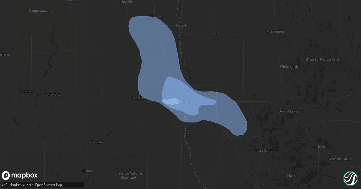
Hail Map in Fargo, ND on June 29, 2019
Get this storm
June 29 map
$229
one time, instant access
Download today. No call, no setup
Keep the $229
Bought the map and want the full workflow? Apply the entire $229 to a subscription within 7 days. None of it is wasted.
Every map, not just this one
This buys you this map. Subscription and you get every map we run, in the markets you choose from a few cities to whole states to nationwide. Plus real-time alerts the moment a storm fires.
Contact data
Name, contact info, occupancy, even credit band for addresses in the footprint. You go from where it hit to who to call.
Become the source they trust
Unlimited branding weather history reports on demand. You already have the documented answer ready for the property owner, and you are the one who showed up with it.
Property data and RoofTrace estimates
Pull up any address you have got, its value and the exact code rules for that jurisdiction, straight from One Click Code. Then RoofTrace estimates the squares, pitch, and roof value, priced the way you price.
Storm reports in Fargo, ND
Fargo, ND
| Date | Description |
|---|---|
| 06/29/20191:02 PM CDT | Peak winds measured at the fargo airport /kfar/. Several large trees were snapped in the north fargo area. |
| 06/29/201912:55 PM CDT | A pickup truck and trailer were blownover and blocking the northbound lane of interstate 28. Time estimated based on radar. |
| 06/29/201912:46 PM CDT | Peak winds measured at the fargo airport /kfar/. |
| 06/29/201912:45 PM CDT | Numerous large trees snapped around the city. A few garage doors were blown in and garage sidewalls blown out in at least two apartment complexes. A semi was tumbled on |
| 06/29/201912:35 PM CDT | Peak winds measured at the fargo airport /kfar/. |
| 06/29/201912:35 PM CDT | Winds at 40 mph gusting to 65 mph reported on the rwis station on the red river bridge. |
| 06/29/201912:34 PM CDT | Power poles broken and small trees snapped in south fargo. |
| 06/29/201912:28 PM CDT | Shingles and construction materials flying in the winds. Multiple spotter report winds gusting to 60 mph or higher. |
All States Impacted by Hail Map on June 29, 2019
- Minnesota
- North Dakota
- New Jersey
- Oklahoma
- Texas
- Delaware
- Maryland
- Pennsylvania
- West Virginia
- Montana
- South Dakota
- Wisconsin
- New York
- Rhode Island
- Massachusetts
- Nebraska
- Illinois
- Virginia
- Ohio
- Wyoming
- Alabama
- Connecticut
- Florida
- Colorado
- Arkansas
- New Hampshire
- Georgia
- Mississippi
- Indiana
- Iowa
- Oregon
- Maine
- Kentucky
- Tennessee
- Louisiana
All Cities Impacted by Hail Map on June 29, 2019
- Saint Vincent, MN
- Pembina, ND
- Lancaster, MN
- Sicklerville, NJ
- Blackwood, NJ
- Stringtown, OK
- Antlers, OK
- Daisy, OK
- Clayton, OK
- Lane, OK
- Atoka, OK
- Wolfe City, TX
- Dover, DE
- Middle River, MD
- Harmony, PA
- Fombell, PA
- Pasadena, MD
- Felton, MN
- Ponemah, MN
- Blackduck, MN
- Kelliher, MN
- Teague, TX
- Buffalo, TX
- Fairfield, TX
- Oakwood, TX
- Cummings, ND
- Mayville, ND
- Hillsboro, ND
- Portland, ND
- Richardton, ND
- Renovo, PA
- Beech Creek, PA
- Philadelphia, PA
- Waldorf, MD
- Grapeland, TX
- Houston, TX
- Pearland, TX
- Pennington, MN
- Deer River, MN
- Tenstrike, MN
- Marcell, MN
- Squaw Lake, MN
- Spring Lake, MN
- Max, MN
- Grand Rapids, MN
- Bemidji, MN
- Northome, MN
- Puposky, MN
- Talmoon, MN
- Bena, MN
- Bigfork, MN
- Hines, MN
- Cohasset, MN
- Bethany, WV
- Wellsburg, WV
- Belcamp, MD
- Bel Air, MD
- Aberdeen, MD
- Abingdon, MD
- Midlothian, TX
- Baytown, TX
- Plentywood, MT
- Webster, ND
- Coatesville, PA
- Parkesburg, PA
- Cammal, PA
- Elizabethville, PA
- Dalmatia, PA
- Mount Pleasant Mills, PA
- Port Trevorton, PA
- Liverpool, PA
- Martin, SD
- Allen, SD
- Decatur, TX
- Christiana, PA
- Strasburg, PA
- Ronks, PA
- Atglen, PA
- Paradise, PA
- Cochranville, PA
- Quarryville, PA
- Bruce, WI
- Weyerhaeuser, WI
- Conklin, NY
- Binghamton, NY
- Susquehanna, PA
- Brackney, PA
- Kirkwood, NY
- Hallstead, PA
- Windsor, NY
- Great Bend, PA
- Maddock, ND
- Lefor, ND
- Gunter, TX
- Howe, TX
- Sherman, TX
- Pawtucket, RI
- Johnston, RI
- Central Falls, RI
- Cumberland, RI
- North Attleboro, MA
- North Providence, RI
- Smithfield, RI
- Seekonk, MA
- Attleboro, MA
- Rehoboth, MA
- Providence, RI
- Lincoln, RI
- Snow, OK
- Winter, WI
- Ellsworth, NE
- Smyrna, DE
- Townsend, DE
- New Columbia, PA
- Watchung, NJ
- Plainfield, NJ
- Vincentown, NJ
- Manchester Township, NJ
- Glyndon, MN
- Webster, WI
- Salix, PA
- South Fork, PA
- Elton, PA
- Johnstown, PA
- Windber, PA
- Malden, IL
- Arlington, IL
- Spring Valley, IL
- Princeton, IL
- Cherry, IL
- Potter, NE
- Dalton, NE
- Gurley, NE
- Woodford, VA
- Fredericksburg, VA
- Crosby, ND
- Alamo, ND
- Crary, ND
- Starkweather, ND
- Devils Lake, ND
- Santa Fe, TX
- Alvin, TX
- Lansford, ND
- Maxbass, ND
- Redlake, MN
- Redby, MN
- Browns Mills, NJ
- Pemberton, NJ
- Nicholson, PA
- Kingsley, PA
- Factoryville, PA
- Fleetville, PA
- Dalton, PA
- Hop Bottom, PA
- Bellefonte, PA
- Centre Hall, PA
- State College, PA
- Kenmare, ND
- Ulster, PA
- Hammondsville, OH
- Carrollton, OH
- Kensington, OH
- Mechanicstown, OH
- Salineville, OH
- Victoria, TX
- Middle River, MN
- Gordon, NE
- Middletown, RI
- Brainerd, MN
- Lock Haven, PA
- Doylesburg, PA
- Blairs Mills, PA
- East Waterford, PA
- Blain, PA
- Mcville, ND
- Pekin, ND
- Massapequa Park, NY
- Farmingdale, NY
- Massapequa, NY
- Amityville, NY
- Lindenhurst, NY
- Copiague, NY
- Reading, PA
- Allenwood, PA
- Asbury Park, NJ
- West Long Branch, NJ
- Oakhurst, NJ
- Eatontown, NJ
- Exeland, WI
- Ojibwa, WI
- Radisson, WI
- Harrison, NE
- Lusk, WY
- Mercersburg, PA
- Towner, ND
- Rugby, ND
- Mott, ND
- Streetman, TX
- Goodridge, MN
- Corrigan, TX
- Diboll, TX
- Glenburn, ND
- Cooperstown, ND
- Finley, ND
- Hope, ND
- Waynesburg, OH
- Danville, IL
- Hoopeston, IL
- Rossville, IL
- Alvin, IL
- Bismarck, IL
- North Bend, PA
- Earleville, MD
- North East, MD
- Emory, TX
- La Grange, TX
- Giddings, TX
- Mylo, ND
- Flasher, ND
- Carson, ND
- Pingree, ND
- Danbury, WI
- Gordon, WI
- Carpenter, WY
- Watson, OK
- Powell, TX
- Kerens, TX
- Rice, TX
- Upperstrasburg, PA
- Fort Loudon, PA
- Bay City, TX
- Randolph, AL
- Penelope, TX
- Hubbard, TX
- Mertens, TX
- Frost, TX
- Malone, TX
- Laporte, MN
- Caney, OK
- Dallas, TX
- Hebron, ND
- New Leipzig, ND
- Canonsburg, PA
- Hainesport, NJ
- Mount Holly, NJ
- Lumberton, NJ
- Celeste, TX
- Farmersville, TX
- Milroy, PA
- Remer, MN
- Henning, IL
- Alexandria, VA
- Lewisburg, PA
- Canton, TX
- Bandera, TX
- Kutztown, PA
- Mertztown, PA
- Celina, TX
- Isle, MN
- Friendsville, PA
- Montrose, PA
- Ennis, TX
- Barry, TX
- Caddo Mills, TX
- Backus, MN
- Kilgore, NE
- Danville, PA
- Shrewsbury, NJ
- Long Branch, NJ
- Oceanport, NJ
- Red Bank, NJ
- Little Silver, NJ
- Deal, NJ
- Fort Monmouth, NJ
- Foster, RI
- Coventry, RI
- Greene, RI
- Saint Thomas, PA
- New Canaan, CT
- New Port Richey, FL
- Moundsville, WV
- Elgin, ND
- Colts Neck, NJ
- Monmouth Beach, NJ
- Rumson, NJ
- Bessemer, AL
- Oakman, AL
- Kemp, TX
- La Moille, IL
- Valley Stream, NY
- Lynbrook, NY
- West Hempstead, NY
- Malverne, NY
- Rockville Centre, NY
- Fleetwood, PA
- Shoemakersville, PA
- Willow City, ND
- Oxford, PA
- Elkton, MD
- Nottingham, PA
- Rising Sun, MD
- Warwick, MD
- Middletown, DE
- Chesapeake City, MD
- Winfield, PA
- Selinsgrove, PA
- Birchwood, WI
- Thief River Falls, MN
- Owego, NY
- Nichols, NY
- Jemison, AL
- Maplesville, AL
- Lawley, AL
- Brigantine, NJ
- Bottineau, ND
- Newburyport, MA
- Salisbury, MA
- Mifflintown, PA
- Atlanta, TX
- Cumby, TX
- Onarga, IL
- Gilman, IL
- Keller, TX
- Zahl, ND
- Grenora, ND
- Malvern, PA
- Monroeville, NJ
- Liverpool, TX
- Kearneysville, WV
- Kramer, ND
- Galeton, PA
- Nanticoke, MD
- Grampian, PA
- Freehold, NJ
- Jackson, NJ
- Curtis Bay, MD
- Newburg, ND
- Upham, ND
- Strasburg, CO
- Byers, CO
- Fort Washington, MD
- Shamokin, PA
- Sunbury, PA
- Paxinos, PA
- Courtenay, ND
- Spraggs, PA
- Waynesburg, PA
- Palestine, TX
- Trinity, TX
- Carr, CO
- Aliquippa, PA
- Taneytown, MD
- Keymar, MD
- Emily, MN
- Arley, AL
- Jasper, AL
- Gonvick, MN
- Hummelstown, PA
- Middletown, PA
- Harrisburg, PA
- Hershey, PA
- Elizabethtown, PA
- Clearbrook, MN
- Shermans Dale, PA
- New Bloomfield, PA
- Elliottsburg, PA
- Landisburg, PA
- Upper Marlboro, MD
- Bowie, MD
- Davidsonville, MD
- King George, VA
- Colbert, OK
- Hendrix, OK
- Calera, OK
- Durant, OK
- Huntsville, TX
- Knox, ND
- Leeds, ND
- Wolford, ND
- York, ND
- Spring Mills, PA
- Brooklyn, MD
- Greenville, TX
- Harrisburg, NE
- Palmyra, PA
- Montgomery, PA
- Ulysses, PA
- De Queen, AR
- Danforth, IL
- Kempton, IL
- Piper City, IL
- Merriman, NE
- Cody, NE
- Dayville, CT
- Danielson, CT
- Purdon, TX
- Dawson, TX
- Woonsocket, RI
- Sheyenne, ND
- Carrington, ND
- Lyme, NH
- East Rochester, OH
- Minerva, OH
- Paxton, IL
- Woodstown, NJ
- Swedesboro, NJ
- Mullica Hill, NJ
- Williamsport, MD
- Nashoba, OK
- Matagorda, TX
- Prince Frederick, MD
- Port Penn, DE
- New Castle, DE
- Longville, MN
- Marsland, NE
- Felton, DE
- Milford, DE
- Harrington, DE
- Frederica, DE
- New Rockford, ND
- Grygla, MN
- Cook, MN
- Mora, MN
- Rolette, ND
- Hawkinsville, GA
- Floodwood, MN
- Wright, MN
- Pine River, MN
- New Auburn, WI
- Chetek, WI
- Bokchito, OK
- Portal, ND
- Columbus, ND
- Noonan, ND
- Emmitsburg, MD
- Union Bridge, MD
- Westminster, MD
- Fessenden, ND
- Lititz, PA
- Valentine, NE
- Glady, WV
- Bowden, WV
- Venus, TX
- Lakota, ND
- Staten Island, NY
- Newfolden, MN
- Strandquist, MN
- Wimbledon, ND
- Tremont, MS
- Almont, ND
- Glen Ullin, ND
- Loganton, PA
- Mill Hall, PA
- Cohasset, MA
- Hull, MA
- Scituate, MA
- Morristown, IN
- Allentown, PA
- Lockesburg, AR
- Mizpah, MN
- Solway, MN
- Wirt, MN
- Bovey, MN
- Cass Lake, MN
- Jewett, TX
- Ganado, TX
- Rice Lake, WI
- Fairview, WV
- Wylie, TX
- Kerrville, TX
- Shevlin, MN
- Davenport, IA
- Walcott, IA
- Beulah, ND
- Dellroy, OH
- Brogue, PA
- Felton, PA
- Roseland, VA
- Tyro, VA
- Burnet, TX
- Jacobson, MN
- Lake Nebagamon, WI
- South Range, WI
- Poplar, WI
- Crookston, NE
- Amity, PA
- Clarksville, PA
- Prosperity, PA
- Jefferson, PA
- Washington, PA
- Marianna, PA
- Beach Haven, NJ
- Pasadena, TX
- Trego, WI
- Spooner, WI
- Dauphin, PA
- Halifax, PA
- Brownsville, PA
- East Millsboro, PA
- La Belle, PA
- Denbo, PA
- Woodway, TX
- Waco, TX
- Crawford, TX
- McGregor, TX
- Magnolia, DE
- Van Alstyne, TX
- Couderay, WI
- Hayward, WI
- Parsons, WV
- Stephen, MN
- Siren, WI
- Annawan, IL
- Pequot Lakes, MN
- Dwight, IL
- Locust Grove, OK
- Chouteau, OK
- Neptune, NJ
- Farmingdale, NJ
- Stevens, PA
- Newmanstown, PA
- Ephrata, PA
- Denver, PA
- Sisters, OR
- Tuthill, SD
- Shippensburg, PA
- Biglerville, PA
- Crosslake, MN
- La Porte, TX
- Seabrook, TX
- Lovelady, TX
- Springbrook, WI
- Gatzke, MN
- New Milford, PA
- Scio, OH
- Downingtown, PA
- Elverson, PA
- Morgantown, PA
- Glenmoore, PA
- Narvon, PA
- Honey Brook, PA
- Strathcona, MN
- Leonard, MN
- Brookston, MN
- Eustace, TX
- Bisbee, ND
- Fergus Falls, MN
- Perrysville, IN
- Georgetown, IL
- Cayuga, IN
- Justin, TX
- Haslet, TX
- Cullom, IL
- Callery, PA
- Evans City, PA
- Mars, PA
- Maud, TX
- Hooks, TX
- Cochran, GA
- Elm Mott, TX
- West, TX
- Clearville, PA
- Binford, ND
- Sutton, ND
- Glenfield, ND
- Cissna Park, IL
- Covington, IN
- Potomac, IL
- Rankin, IL
- Wellington, IL
- Williamsport, IN
- State Line, IN
- Lewisville, OH
- Summerfield, OH
- Bruceton Mills, WV
- Freeport, TX
- Morgantown, WV
- Dilliner, PA
- Maidsville, WV
- Mount Morris, PA
- Prosper, TX
- Anna, TX
- Crosby, MN
- Amsterdam, OH
- Lebanon, PA
- Chatsworth, NJ
- Barnegat, NJ
- Phoenixville, PA
- Chester Springs, PA
- Essex, MD
- Gunpowder, MD
- Rosedale, MD
- Minong, WI
- Merrifield, MN
- Glassboro, NJ
- Pitman, NJ
- Sewell, NJ
- Newport, NJ
- Elysburg, PA
- Vestal, NY
- Italy, TX
- Texarkana, TX
- Marietta, PA
- Mount Joy, PA
- Annapolis, MD
- Bowdoin, ME
- Litchfield, ME
- Sabattus, ME
- Elkins, WV
- Sabin, MN
- Hawley, MN
- Martinsburg, WV
- Inwood, WV
- Ranson, WV
- Charles Town, WV
- Shenandoah Junction, WV
- Parmelee, SD
- Manassas, VA
- Nashwauk, MN
- Hibbing, MN
- Grace City, ND
- Gibbon Glade, PA
- Farmington, PA
- Berkeley Springs, WV
- Mcgregor, MN
- Palisade, MN
- Williamstown, NJ
- Roseau, MN
- Plummer, MN
- Harwood, MD
- Edgewater, MD
- Nevada, TX
- Lusby, MD
- Hopkinsville, KY
- Manchester, NH
- Chester, NH
- Kingston, NH
- Auburn, NH
- Derry, NH
- Sandown, NH
- Londonderry, NH
- Danville, NH
- Cranberry Township, PA
- Baden, PA
- Freedom, PA
- Honey Grove, PA
- New Germantown, PA
- Newville, PA
- Oley, PA
- Petersburg, ND
- Davis, WV
- Eglon, WV
- Oakland, MD
- Cando, ND
- Neelyton, PA
- Dry Run, PA
- Cross Plains, TX
- Federal Dam, MN
- Finlayson, MN
- McGrath, MN
- Rome, PA
- Stillwater, PA
- Greencastle, PA
- Fairfield, PA
- Waynesboro, PA
- North Scituate, RI
- Chepachet, RI
- Millersville, PA
- Conestoga, PA
- Lancaster, PA
- Washington Boro, PA
- Candor, NY
- Saint Francis, SD
- Medford, NJ
- Casselton, ND
- Tamarack, MN
- Aurora, WV
- Terra Alta, WV
- Dornsife, PA
- Herndon, PA
- North Kingstown, RI
- Crane Hill, AL
- Boalsburg, PA
- Wilton, IA
- Moscow, IA
- Eagle Rock, VA
- Cove, AR
- Port Republic, MD
- Huntingtown, MD
- Oberon, ND
- Toulon, IL
- Galva, IL
- Badger, MN
- Norton, MA
- Greenville, RI
- Jamestown, ND
- Wellsville, OH
- Douglassville, TX
- Hull, TX
- Minnewaukan, ND
- Karlstad, MN
- Greenbush, MN
- Wrenshall, MN
- Barnum, MN
- Cloquet, MN
- Carlton, MN
- Joppa, MD
- Rushville, NE
- Covington, VA
- Memphis, TN
- Alto, TX
- Deerwood, MN
- Morristown, NJ
- Basking Ridge, NJ
- New Vernon, NJ
- Port Allegany, PA
- Malvern, OH
- Kitzmiller, MD
- Severn, MD
- Boonsboro, MD
- Corsicana, TX
- Burke, VA
- Fairfax Station, VA
- Springfield, VA
- Rappahannock Academy, VA
- Rock Island, IL
- Ambridge, PA
- Monaca, PA
- Sonora, KY
- Upton, KY
- Tolna, ND
- Park Rapids, MN
- Blooming Grove, TX
- Anamoose, ND
- Martin, ND
- Middleburg, PA
- Beavertown, PA
- Houston, PA
- Meadow Lands, PA
- Hickory, PA
- Trail, MN
- Gully, MN
- Valencia, PA
- Ohiopyle, PA
- Dunbar, PA
- Bynum, TX
- Pipe Creek, TX
- Mico, TX
- Saint Leonard, MD
- La Marque, TX
- Hitchcock, TX
- Texas City, TX
- Dickinson, TX
- Stone Lake, WI
- Anderson, TX
- Chesapeake Beach, MD
- Sunderland, MD
- Owings, MD
- Jermyn, PA
- Olyphant, PA
- Newton, NJ
- Andover, NJ
- Ironton, MN
- Aitkin, MN
- China Spring, TX
- Valley Mills, TX
- Stockton, IA
- Brandywine, MD
- Dunkirk, MD
- Holyoke, MN
- Conroe, TX
- Porter, TX
- Red Lake Falls, MN
- Blackstone, MA
- North Smithfield, RI
- Bellingham, MA
- Albright, WV
- Outing, MN
- Bagley, MN
- Swatara, MN
- Walker, MN
- Hill City, MN
- Galesburg, ND
- Clifford, ND
- Bedford, PA
- Pennsville, NJ
- Warren Center, PA
- Le Raysville, PA
- McVeytown, PA
- Lewistown, PA
- Meadowlands, MN
- Barnesville, MN
- Moorhead, MN
- Coudersport, PA
- Senecaville, OH
- Accident, MD
- Friendsville, MD
- McHenry, MD
- Swanton, MD
- Aquasco, MD
- Follansbee, WV
- Brilliant, OH
- Claysville, PA
- West Alexander, PA
- Mingo Junction, OH
- Steubenville, OH
- Colliers, WV
- Avella, PA
- Forreston, TX
- Waxahachie, TX
- Blue Grass, IA
- Bridgewater, NJ
- Bedminster, NJ
- Kerens, WV
- Montrose, WV
- Doddridge, AR
- Bivins, TX
- Rodessa, LA
- Jud, ND
- Kittery, ME
- Clarence, IA
- Tipton, IA
- Bennett, IA
- Shade Gap, PA
- Burnt Cabins, PA
- Orbisonia, PA
- Pontiac, IL
- Salem, NJ
- Bear, DE
- Red Oak, TX
- Monmouth, ME
- Greene, ME
- Burlington, WV
- Little Meadows, PA
- Apalachin, NY
- Cambridge, OH
- Dilworth, MN
- Williamsport, PA
- Alvarado, TX
- Crockett, TX
- West Branch, IA
- Ravenna, TX
- Coleman, TX
- Wickes, AR
- Gap, PA
- Willow River, MN
- Natural Dam, AR
- Chestertown, MD
- Coal Township, PA
- Northumberland, PA
- Milton, PA
- Millersburg, PA
- West Milton, PA
- Trevorton, PA
- Shamokin Dam, PA
- Holbrook, PA
- Lisbon, OH
- Hanoverton, OH
- Clinton, MD
- Bingham, NE
- Renfrew, PA
- Annville, PA
- League City, TX
- Denison, TX
- White Marsh, MD
- Nottingham, MD
- Niagara, ND
- Moatsville, WV
- Scurry, TX
- Cross Fork, PA
- Reserve, MT
- Succasunna, NJ
- Mine Hill, NJ
- Randolph, NJ
- Dover, NJ
- Stanhope, NJ
- Landing, NJ
- Mount Arlington, NJ
- Ledgewood, NJ
- Kenvil, NJ
- Jersey Mills, PA
- Waterville, PA
- Orrtanna, PA
- Gardners, PA
- Centreville, MD
- Church Hill, MD
- Howard, PA
- Madisonburg, PA
- Ladysmith, WI
- Burgettstown, PA
- Kemah, TX
- New Boston, TX
- Ashdown, AR
- Fort Worth, TX
- Grand Saline, TX
- Portersville, PA
- New Castle, PA
- Centerville, TX
- Wilmington, DE
- Esmond, ND
- Fincastle, VA
- Dudley, GA
- Forbes, MN
- Purgitsville, WV
- Cleveland, TX
- Stevensville, MD
- Saginaw, MN
- Alborn, MN
- Sandstone, MN
- Akeley, MN
- Wiggins, CO
- Granville, WV
- Willow Hill, PA
- Fannettsburg, PA
- Hackensack, MN
- Hope, RI
- Sterling, CT
- East Greenwich, RI
- West Warwick, RI
- Rio Medina, TX
- Mather, PA
- Fargo, ND
- Mapleton, ND
- West Fargo, ND
- Emington, IL
- Elkridge, MD
- Newark, DE
- Gatesville, TX
- Kinzers, PA
- Jacksonville, TX
- Slippery Rock, PA
- Warwick, ND
- Lancaster, TX
- Hutchins, TX
- Humble, TX
- Friendswood, TX
- Plainville, MA
- Commerce, TX
- Paw Paw, WV
- Bloomery, WV
- Talbotton, GA
- Plaza, ND
- Harvey, ND
- South Plainfield, NJ
- Dunellen, NJ
- Warren, NJ
- Piscataway, NJ
- Scotch Plains, NJ
- Rowlesburg, WV
- Jackson, PA
- Thompson, PA
- Keyser, WV
- Lexington, VA
- Glasgow, VA
- Natural Bridge, VA
- Kopperl, TX
- Center Point, TX
- Goldsboro, MD
- Henderson, MD
- Carrollton, TX
- The Colony, TX
- Blanchard, PA
- Wexford, PA
- Bradfordwoods, PA
- Butler, PA
- New Kensington, PA
- Newmarket, NH
- Durham, NH
- Outlook, MT
- Akron, OH
- Mount Wolf, PA
- Manchester, PA
- York, PA
- Andrews Air Force Base, MD
- Temple Hills, MD
- Suitland, MD
- Mckinney, TX
- Greenfield, IN
- Shelbyville, IN
- Fountaintown, IN
- Massena, NY
- Mitchell, OR
- Big Falls, MN
- Rusk, TX
- Chester, TX
- Glen Burnie, MD
- Tow, TX
- Glen Rose, TX
- Saint Hilaire, MN
- Parkville, MD
- Baltimore, MD
- Rockbridge Baths, VA
- Lampasas, TX
- Mchenry, ND
- Markleysburg, PA
- Woodbridge, VA
- Howell, NJ
- Belmar, NJ
- Tuscumbia, AL
- Beaver, PA
- Rochester, PA
- Mifflin, PA
- Sturgeon Lake, MN
- Gracey, KY
- Linden, TX
- Argyle, MN
- Easton, PA
- Bangor, PA
- Phillipsburg, NJ
- Paris, OH
- McDonald, PA
- Wheeling, WV
- Westport, PA
- Rocky Ridge, MD
- Thurmont, MD
- Selma, VA
- Effie, MN
- Gillham, AR
- Dunseith, ND
- Agate, ND
- Camden Wyoming, DE
- Clayton, DE
- Dover Afb, DE
- Hartly, DE
- Woodside, DE
- Marydel, MD
- Marydel, DE
- Viola, DE
- Cheswold, DE
- Scranton, PA
- Clarks Summit, PA
- Sugar Land, TX
- Drake, ND
- Donahue, IA
- Long Grove, IA
- Strattanville, PA
- Summerville, PA
- Spring Glen, PA
- Williamstown, PA
- Mountainburg, AR
- Cross Junction, VA
- McConnellsburg, PA
- Lawton, ND
- Hinckley, MN
- Kingsville, MD
- Perry Hall, MD
- Glen Arm, MD
- Upper Falls, MD
- Asbury, NJ
- Horatio, AR
- Haddonfield, NJ
- Oaklyn, NJ
- Audubon, NJ
- Collingswood, NJ
- Hopwood, PA
- Gaines, PA
- Portage, PA
- Hughesville, MD
- Mannington, WV
- Duncannon, PA
- Newport, PA
- Lincoln University, PA
- Landenberg, PA
- Three Springs, PA
- Silver Spring, MD
- Delaware City, DE
- Saint Georges, DE
- Bethpage, NY
- Exeter, NH
- East Kingston, NH
- Gladstone, ND
- Dickinson, ND
- Taylor, ND
- Mesquite, TX
- Carteret, NJ
- Middlesex, NJ
- Budd Lake, NJ
- Metuchen, NJ
- Gillette, NJ
- Rahway, NJ
- Elizabeth, NJ
- Colonia, NJ
- Millington, NJ
- Mendham, NJ
- Iselin, NJ
- Linden, NJ
- Fanwood, NJ
- Hopatcong, NJ
- Mountainside, NJ
- Westfield, NJ
- Avenel, NJ
- Clark, NJ
- Cranford, NJ
- Stirling, NJ
- Sewaren, NJ
- Garwood, NJ
- Flanders, NJ
- Denville, NJ
- Morris Plains, NJ
- Bayonne, NJ
- Edison, NJ
- Port Reading, NJ
- Fords, NJ
- Netcong, NJ
- Roselle, NJ
- Woodbridge, NJ
- Roselle Park, NJ
- Berkeley Heights, NJ
- Bernardsville, NJ
- Elizabethport, NJ
- Sidman, PA
- Chambersburg, PA
- Walnut Bottom, PA
- Pedricktown, NJ
- Berlin, NJ
- Arthur, ND
- Argusville, ND
- Harwood, ND
- Gardner, ND
- Georgetown, MN
- Grandin, ND
- Hunter, ND
- Amenia, ND
- Horace, ND
- Blanchard, ND


