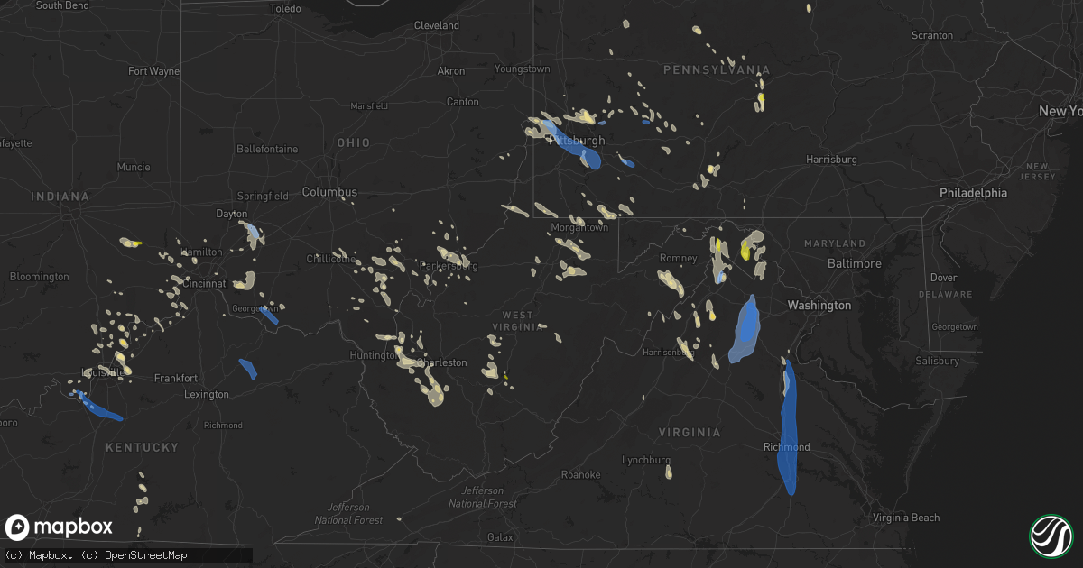
Hail Map in West Virginia on June 22, 2022
Get this storm
June 22 map
$229
one time, instant access
Download today. No call, no setup
Keep the $229
Bought the map and want the full workflow? Apply the entire $229 to a subscription within 7 days. None of it is wasted.
Every map, not just this one
This buys you this map. Subscription and you get every map we run, in the markets you choose from a few cities to whole states to nationwide. Plus real-time alerts the moment a storm fires.
Contact data
Name, contact info, occupancy, even credit band for addresses in the footprint. You go from where it hit to who to call.
Become the source they trust
Unlimited branding weather history reports on demand. You already have the documented answer ready for the property owner, and you are the one who showed up with it.
Property data and RoofTrace estimates
Pull up any address you have got, its value and the exact code rules for that jurisdiction, straight from One Click Code. Then RoofTrace estimates the squares, pitch, and roof value, priced the way you price.
Storm reports in West Virginia
West Virginia
| Date | Description |
|---|---|
| 06/22/20226:58 PM CDT | 2 trees down. |
| 06/22/20226:50 PM CDT | Tree down along o brion road. |
| 06/22/20226:47 PM CDT | Tree down. |
| 06/22/20226:41 PM CDT | Tree down across cumberland rd near potomac ave |
| 06/22/20226:41 PM CDT | A few trees down on horseshoe run road. |
| 06/22/20226:40 PM CDT | Trees snapped or uprooted |
| 06/22/20226:40 PM CDT | Trees reported blown down and one over powerlines along country club road. |
| 06/22/20226:32 PM CDT | Tree fell onto apartment complex. |
| 06/22/20226:32 PM CDT | Tree down blocking road. |
| 06/22/20226:30 PM CDT | Trees reported blown down along chestnut ridge road. |
| 06/22/20226:28 PM CDT | Several trees blown down |
| 06/22/20226:23 PM CDT | Large tree down. Mossman avenue closed. |
| 06/22/20226:20 PM CDT | Tree down on mcmullen hwy near dawson. |
| 06/22/20225:43 PM CDT | Preston county ema reported multiple trees down and a few damaged barns. |
| 06/22/20225:09 PM CDT | Tree down. |
| 06/22/20224:37 PM CDT | Tree down blocking intersection. |
| 06/22/20224:31 PM CDT | Tree down. |
| 06/22/20224:13 PM CDT | Tree down blocking intersection. |
| 06/22/20223:49 PM CDT | A tree blew down near valley rd and fred michael ln. |
| 06/22/20223:38 PM CDT | A few trees blew down near the 2500 block of timber ridge rd. |
| 06/22/20223:25 PM CDT | Numerous trees and wires blew down between charles town and shepherdstown. |
| 06/22/20223:02 PM CDT | Numerous trees and wires blew down near the jefferson/loudoun county line. |
| 06/22/20222:55 PM CDT | Numerous trees and wires blew down between charles town and shepherdstown. |
| 06/22/20222:55 PM CDT | A local report indicates 1.00 inch wind near 2 E MARTINSBURG |
| 06/22/20222:55 PM CDT | Report of damage to trees and penny sized hail near the 470 block of gosling marsh rd. |
| 06/22/20228:42 AM CDT | Multiple trees down between hilldale and talcott. Time estimated from radar. |
| 06/22/20228:35 AM CDT | Trees down along route 20 in hinton. Time estimated from radar. |
| 06/22/20224:10 AM CDT | At 910 PM EDT, a severe thunderstorm was located near Madison, moving southeast at 20 mph. HAZARD...60 mph wind gusts and quarter size hail. SOURCE...Radar indicated. IMPACT...Hail damage to vehicles is expected. Expect wind damage to roofs, siding, and trees. Locations impacted include... Madison, Van, Wharton, Bald Knob, Julian, Amherstdale-Robinette, Danville, Whitesville, Sylvester, Seth, Turtle Creek, Prenter, Woodville, Ashford, Dorothy, Foster, Stickney, Blair, Artie and Sharples.This includes Route 119 between mile markers 46 and 60. |
| 06/22/20223:54 AM CDT | At 854 PM EDT, a severe thunderstorm was located 8 miles northeast of Madison, moving southeast at 15 mph. HAZARD...60 mph wind gusts and quarter size hail. SOURCE...Radar indicated. IMPACT...Hail damage to vehicles is expected. Expect wind damage to roofs, siding, and trees. Locations impacted include... Madison, Marmet, Van, Burnwell, Whitesville, Sylvester, Seth, Leewood, Prenter, Ashford, Eskdale, Foster and Racine.This includes West Virginia Turnpike between mile markers 68 and 70. |
| 06/22/20223:41 AM CDT | At 840 PM EDT, a severe thunderstorm was located over Quinwood, moving southeast at 35 mph. HAZARD...60 mph wind gusts and quarter size hail. SOURCE...Radar indicated. IMPACT...Hail damage to vehicles is expected. Expect wind damage to roofs, siding, and trees. Locations impacted include... Rainelle... Rupert... Quinwood... Bingham... Trout... Williamsburg... and Meadow Bluff. |
| 06/22/20223:31 AM CDT | At 831 PM EDT, a severe thunderstorm was located 7 miles southwest of Summersville, moving southeast at 20 mph. HAZARD...60 mph wind gusts and quarter size hail. SOURCE...Radar indicated. IMPACT...Hail damage to vehicles is expected. Expect wind damage to roofs, siding, and trees. Locations impacted include... Summersville, Kesslers Cross Lanes, Mount Nebo and Drennan. This includes Route 19 between mile markers 25 and 41. |
| 06/22/20223:29 AM CDT | At 829 PM EDT, a severe thunderstorm was located near Culloden, or 7 miles northeast of Hamlin, moving southeast at 20 mph. HAZARD...60 mph wind gusts and quarter size hail. SOURCE...Radar indicated. IMPACT...Hail damage to vehicles is expected. Expect wind damage to roofs, siding, and trees. Locations impacted include... Tornado, Alum Creek, Julian, Griffithsville, Sod, Woodville, Alkol and Yawkey.This includes Route 119 between mile markers 58 and 71. |
| 06/22/20223:16 AM CDT | At 816 PM EDT, a severe thunderstorm was located over Philippi, moving south at 70 mph. HAZARD...60 mph wind gusts and quarter size hail. SOURCE...Radar indicated. IMPACT...Hail damage to vehicles is expected. Expect wind damage to roofs, siding, and trees. Locations impacted include... Grafton, Philippi, Audra State Park, Belington, Flemington, Montrose, Moatsville, Volga, Knottsville, Nestorville, Tygart Lake State Park, Kerens, Galloway and Thornton. |
| 06/22/20223:05 AM CDT | At 805 PM EDT, a severe thunderstorm was located over Milton, or 12 miles north of Hamlin, moving east at 30 mph. HAZARD...60 mph wind gusts and quarter size hail. SOURCE...Radar indicated. IMPACT...Hail damage to vehicles is expected. Expect wind damage to roofs, siding, and trees. Locations impacted include... Nitro, Hurricane, Milton, Poca, Culloden, Teays Valley and Alum Creek.This includes Interstate 64 in West Virginia between mile markers 23and 45. |
| 06/22/20223:02 AM CDT | At 801 PM EDT, a severe thunderstorm was located near Moorefield, moving southeast at 40 mph. HAZARD...60 mph wind gusts and quarter size hail. SOURCE...Radar indicated. IMPACT...Damaging winds will cause some trees and large branches to fall. This could injure those outdoors, as well as damage homes and vehicles. Roadways may become blocked by downed trees. Localized power outages are possible. Unsecured light objects may become projectiles. Locations impacted include... Woodstock, Moorefield, Basye-Bryce Mountain, Mathias, Basye, Edinburg, Orkney Springs, Bean Settlement, Old Fields, Harmony, Mcneill, Perry, Lost City, Lost River, Fisher, Baker, Mount Clifton, Inkerman, Jerome and Mccauley. |
| 06/22/20222:57 AM CDT | At 757 PM EDT, severe thunderstorms were located along a line extending from 8 miles northeast of Terra Alta to near Pleasant Valley, moving southeast at 30 mph. HAZARD...60 mph wind gusts. SOURCE...Radar indicated. IMPACT...Expect damage to trees and power lines, resulting in some power outages. Locations impacted include... Fairmont, Kingwood, Parsons, Terra Alta, Davis, Thomas, Rowlesburg, Pleasant Valley, Newburg, Hendricks, Hambleton, and Reedsville. |
| 06/22/20222:49 AM CDT | At 749 PM EDT, a severe thunderstorm was located near Grafton, moving south at 50 mph. HAZARD...60 mph wind gusts and quarter size hail. SOURCE...Radar indicated. IMPACT...Hail damage to vehicles is expected. Expect wind damage to roofs, siding, and trees. Locations impacted include... Clarksburg, Grafton, Philippi, Bridgeport, Shinnston, Stonewood, Nutter Fort, Lumberport, Anmoore, Enterprise, Flemington, Montrose, Moatsville, Rosemont, Knottsville, Nestorville, Meadland, Tygart Lake State Park, Thornton and McGee.This includes the following highways... Interstate 79 between mile markers 116 and 128. Route 50 in West Virginia between mile markers 77 and 82. |
| 06/22/20222:41 AM CDT | At 740 PM EDT, a severe thunderstorm was located near Belmont, or 7 miles south of St. Marys, moving east at 35 mph. HAZARD...60 mph wind gusts and quarter size hail. SOURCE...Radar indicated. IMPACT...Hail damage to vehicles is expected. Expect wind damage to roofs, siding, and trees. Locations impacted include... Harrisville, Pennsboro, North Bend State Park, Ellenboro, Cairo, Schultz, Pike, Nutter Farm and Highland.This includes Route 50 in West Virginia between mile markers 21 and45. |
| 06/22/20222:38 AM CDT | At 737 PM EDT, a severe thunderstorm was located 7 miles southeast of Big Otter, or 9 miles northeast of Clay, moving southeast at 40 mph. HAZARD...60 mph wind gusts and quarter size hail. SOURCE...Radar indicated. IMPACT...Hail damage to vehicles is expected. Expect wind damage to roofs, siding, and trees. Locations impacted include... Clay, Birch River, Harrison, Widen, Strange Creek, Ivydale and Muddlety.This includes the following highways... Interstate 79 between mile markers 52 and 55. Route 19 between mile markers 47 and 65. |
| 06/22/20222:19 AM CDT | At 719 PM EDT, a severe thunderstorm was located near Boaz, or near Marietta, moving east at 50 mph. HAZARD...60 mph wind gusts and quarter size hail. SOURCE...Radar indicated. IMPACT...Hail damage to vehicles is expected. Expect wind damage to roofs, siding, and trees. Locations impacted include... Parkersburg, Marietta, Belpre, Vienna, Williamstown, Belmont, Boaz, Mineralwells, North Hills, Willow Island, Schultz, Waverly, Fleming and Davisville.This includes the following highways... Interstate 77 in West Virginia between mile markers 171 and 186. Interstate 77 in Ohio between mile markers 1 and 2. Route 50 in West Virginia between mile markers 5 and 23. |
| 06/22/20222:15 AM CDT | At 715 PM EDT, a cluster of severe thunderstorms was centered near Kingwood, moving southeast at 25 mph. HAZARD...60 mph wind gusts. SOURCE...Radar indicated. IMPACT...Expect damage to trees and power lines, resulting in some power outages. Locations impacted include... Kingwood, Terra Alta, Thomas, Rowlesburg, Newburg, Reedsville, Masontown, Albright, Tunnelton, Hannahsville, Valley Point, and Elgon. |
| 06/22/20222:07 AM CDT | At 707 PM EDT, severe thunderstorms were located along a line extending from La Vale to near Kingwood, moving south at 30 mph. HAZARD...60 mph wind gusts and quarter size hail. SOURCE...Radar indicated. IMPACT...Damaging winds will cause some trees and large branches to fall. This could injure those outdoors, as well as damage homes and vehicles. Roadways may become blocked by downed trees. Localized power outages are possible. Unsecured light objects may become projectiles. Locations impacted include... Frostburg, Keyser, Mountain Lake Park, Oakland, Westernport, Bel Air, Bayard, Bittinger, Lonaconing, Piedmont, Loch Lynn Heights, Deer Park, Accident, Elk Garden, Kitzmiller, Cresaptown, Eckhart Mines, Mount Savage, Rawlings and Barton. |
| 06/22/20221:57 AM CDT | At 657 PM EDT, a severe thunderstorm was located 8 miles west of Rutland, moving southeast at 40 mph. HAZARD...60 mph wind gusts and quarter size hail. SOURCE...Radar indicated. IMPACT...Hail damage to vehicles is expected. Expect wind damage to roofs, siding, and trees. Locations impacted include... Point Pleasant, Pomeroy, Racine, Rutland, New Haven, Mason, Middleport, Syracuse, Hartford City, Vinton, Wilkesville, Cheshire, Lakin, Dyesville, Salem Center, Harrisonville, Dexter and Kyger. |
| 06/22/20221:56 AM CDT | At 656 PM EDT, a severe thunderstorm was located 7 miles northeast of Cameron, or 13 miles west of Waynesburg, moving southeast at 30 mph. HAZARD...60 mph wind gusts. SOURCE...Radar indicated. IMPACT...Expect damage to trees and power lines, resulting in some power outages. Locations impacted include... Waynesburg, Cassville, Rogersville, Aleppo, Blacksville, Mount Morris, New Freeport, Spraggs, McCurdyville, Pentress, Wana, and Brave. |
| 06/22/20221:26 AM CDT | At 626 PM EDT, severe thunderstorms were located along a line extending from near Meyersdale to Point Marion, moving southeast at 40 mph. HAZARD...60 mph wind gusts and quarter size hail. SOURCE...Radar indicated. IMPACT...Damaging winds will cause some trees and large branches to fall. This could injure those outdoors, as well as damage homes and vehicles. Roadways may become blocked by downed trees. Localized power outages are possible. Unsecured light objects may become projectiles. Locations impacted include... Frostburg, Mountain Lake Park, Oakland, Westernport, Bel Air, Bayard, Bittinger, La Vale, Lonaconing, Piedmont, Grantsville, Loch Lynn Heights, Friendsville, Deer Park, Accident, Cresaptown, Potomac Park, Eckhart Mines, Mount Savage and Rawlings. |
| 06/22/202212:52 AM CDT | At 552 PM EDT, a severe thunderstorm was located 8 miles southwest of Belmont, or 9 miles east of Parkersburg, moving southeast at 20 mph. HAZARD...60 mph wind gusts and half dollar size hail. SOURCE...Radar indicated. IMPACT...Hail damage to vehicles is expected. Expect wind damage to roofs, siding, and trees. Locations impacted include... North Bend State Park, Ellenboro, Cairo, Schultz, Nutter Farm and Pike.This includes Route 50 in West Virginia between mile markers 17 and36. |
| 06/22/202212:26 AM CDT | At 526 PM EDT, a severe thunderstorm was located near Vienna, or near Belpre, moving southeast at 25 mph. HAZARD...60 mph wind gusts and quarter size hail. SOURCE...Radar indicated. IMPACT...Hail damage to vehicles is expected. Expect wind damage to roofs, siding, and trees. Locations impacted include... Parkersburg, Marietta, Belpre, Vienna, Williamstown, Boaz, North Hills, Waverly, Fleming and Willow Island.This includes the following highways... Interstate 77 in West Virginia between mile markers 173 and 186. Route 50 in West Virginia between mile markers 6 and 17. |
| 06/22/202212:22 AM CDT | At 522 PM EDT, a severe thunderstorm was located over Washington, or near Belpre, moving southeast at 20 mph. HAZARD...60 mph wind gusts and quarter size hail. SOURCE...Radar indicated. IMPACT...Hail damage to vehicles is expected. Expect wind damage to roofs, siding, and trees. Locations impacted include... Parkersburg, Belpre, Lubeck, Washington, Mineralwells, Blennerhassett, Davisville and Little Hocking.This includes the following highways... Interstate 77 in West Virginia between mile markers 164 and 176. Route 50 in West Virginia between mile markers 1 and 15. |
| 06/21/202211:27 PM CDT | At 427 PM EDT, a severe thunderstorm was located near Inwood, or near Greenwood, moving southeast at 35 mph. HAZARD...60 mph wind gusts and quarter size hail. SOURCE...Radar indicated. IMPACT...Damaging winds will cause some trees and large branches to fall. This could injure those outdoors, as well as damage homes and vehicles. Roadways may become blocked by downed trees. Localized power outages are possible. Unsecured light objects may become projectiles. Locations impacted include... Winchester, Millwood Pike, Berryville, Inwood, Cedar Grove, Gaylord, Clear Brook, Ridgeway, Bunker Hill, Oakland, Stephenson, Cedar Hill, Albin, Unger, Stringtown, Brucetown, Glengary, Omps, Greenwood and Shanghai. |
| 06/21/202211:08 PM CDT | At 407 PM EDT, severe thunderstorms were located along a line extending from near Martinsburg to near Oatlands, moving southwest at 30 mph. HAZARD...60 mph wind gusts and quarter size hail. SOURCE...Radar indicated. IMPACT...Damaging winds will cause some trees and large branches to fall. This could injure those outdoors, as well as damage homes and vehicles. Roadways may become blocked by downed trees. Localized power outages are possible. Unsecured light objects may become projectiles. Locations impacted include... Leesburg, Winchester, Martinsburg, Charles Town, Millwood Pike, Purcellville, Ranson, Berryville, Inwood, Middleburg, Round Hill, The Plains, Delaplane, Oatlands, Corporation Of Ranson, Bluemont, Marshall, Boyce, Hamilton and Middleway. |
| 06/21/202210:59 PM CDT | At 359 PM EDT, a severe thunderstorm was located over Chester, or over East Liverpool, moving southeast at 25 mph. HAZARD...60 mph wind gusts. SOURCE...Radar indicated. IMPACT...Expect damage to trees and power lines, resulting in some power outages. Locations impacted include... Weirton, East Liverpool, Wellsville, Calcutta, Ohioville, Chester, Burgettstown, Newell, New Manchester, Georgetown, Hookstown, and Frankfort Springs. |
| 06/21/202210:49 PM CDT | At 348 PM EDT, a severe thunderstorm was located 7 miles northwest of Timberville, or 17 miles north of Harrisonburg, moving southeast at 35 mph. HAZARD...60 mph wind gusts and quarter size hail. SOURCE...Radar indicated. IMPACT...Damaging winds will cause some trees and large branches to fall. This could injure those outdoors, as well as damage homes and vehicles. Roadways may become blocked by downed trees. Localized power outages are possible. Unsecured light objects may become projectiles. Locations impacted include... Harrisonburg, Broadway, Timberville, Shenandoah, Massanutten, Elkton, Tunis, Penn Laird, Yankeetown, Cherry Grove, Lacey Spring, Fulks Run, Singers Glen, Linville, Bergton and Keezletown. |
| 06/21/20229:02 PM CDT | Tree down along pete amos road near rock camp. |
| 06/21/20228:57 PM CDT | Tree down near greenville. |
| 06/21/20228:55 PM CDT | Tree down near bozoo. |
| 06/21/20228:52 PM CDT | Tree down near ballard. |
| 06/21/20228:51 PM CDT | 2 trees down on highway 219 near pickaway. |
| 06/21/20228:42 PM CDT | Corrects previous tstm wnd dmg report from 1 wsw talcott. Multiple trees down between hilldale and talcott. Time estimated from radar. |
| 06/21/20228:35 PM CDT | Corrects previous tstm wnd dmg report from 1 ne hinton. Trees down along route 20 in hinton. Time estimated from radar. |
| 06/21/20228:31 PM CDT | Several trees snapped or blown down near brooks... Along the new river. |
| 06/21/20228:20 PM CDT | Corrects report type of previous flash flood report from 8 ne madison. Multiple trees down along daniel boone parkway in peytona. |
| 06/21/20228:12 PM CDT | Large limbs down along raders valley road. |
| 06/21/20228:10 PM CDT | Trees down along county road 9 from thunderstorm gust-front. |
| 06/21/20228:10 PM CDT | Several trees down in nellis. |
| 06/21/20228:10 PM CDT | Trees and power lines down in danville along price branch road. |
| 06/21/20228:05 PM CDT | Trees down along kieffer road. |
| 06/21/20228:05 PM CDT | Tree down at home in crawley from thunderstorm gust-front. |
| 06/21/20228:01 PM CDT | Tree down along farmdale road from thunderstorm gust-front. |
| 06/21/20227:55 PM CDT | A tree and power lines were blown down. |
| 06/21/20227:50 PM CDT | Multiple trees down in the charmco area. |
| 06/21/20227:44 PM CDT | Tree down near nicholas county line. Time estimated from radar. |
| 06/21/20227:40 PM CDT | Tree blown down near alum creek. |
| 06/21/20227:38 PM CDT | A local report indicates 1.00 inch wind near 6 S SUMMERSVILLE |
| 06/21/20227:30 PM CDT | Multple trees down throughout the city of charleston. A few roads along which trees fell include hickory road... Sissonville drive... Woodbridge drive... Kanawha blvd.. |
| 06/21/20227:22 PM CDT | Multiple trees down along chestnut ridge rd. Time estimated from radar. |
| 06/21/20227:20 PM CDT | Multiple trees down along main street in hurricane. |
| 06/21/20227:10 PM CDT | Trees down in ona. |
| 06/21/20227:10 PM CDT | Tree down along coleman creek rd. Time estimated from radar. |
| 06/21/20227:09 PM CDT | A few trees down on mountaineer highway. |
| 06/21/20227:05 PM CDT | Multiple trees down in grafton along sandy creek road... Haymond road... Plum run road... Yates avenue... And victory avenue. |
| 06/21/20227:00 PM CDT | Tree blown down along irontown road in independence. |
All States Impacted by Hail Map on June 22, 2022
Cities Impacted by Hail Map on June 22, 2022
- Bedford, PA
- Xenia, OH
- Jamestown, OH
- New Lexington, OH
- Somerset, OH
- Blossburg, PA
- Wellsboro, PA
- Clifton Springs, NY
- Shortsville, NY
- Caldwell, OH
- Macksburg, OH
- Dexter City, OH
- Greensburg, PA
- Benezett, PA
- Huntingdon, PA
- State College, PA
- Boalsburg, PA
- Markleysburg, PA
- Palmyra, NY
- Bloomingdale, OH
- Coolville, OH
- Guysville, OH
- Frenchville, PA
- Cumberland, MD
- Oldtown, MD
- Chillicothe, OH
- Philippi, WV
- Lost Creek, WV
- Bridgeport, WV
- Mount Clare, WV
- Brave, PA
- Blacksville, WV
- Spraggs, PA
- Holbrook, PA
- New Freeport, PA
- Aleppo, PA
- Wind Ridge, PA
- West Point, KY
- Cedar Grove, IN
- New Trenton, IN
- West Harrison, IN
- Brookville, IN
- South Webster, OH
- Minford, OH
- Bush, LA
- Covington, LA
- Franklinton, LA
- Cincinnati, OH
- Harrison, OH
- Burkesville, KY
- Henryville, IN
- Memphis, IN
- Borden, IN
- Hopewell, PA
- Saxton, PA
- Woodbury, PA
- Keedysville, MD
- Fairplay, MD
- Sharpsburg, MD
- Shepherdstown, WV
- Falling Waters, WV
- Boonsboro, MD
- Martinsburg, WV
- Kearneysville, WV
- Hagerstown, MD
- Williamsport, MD
- Gerrardstown, WV
- Clear Brook, VA
- Winchester, VA
- Berkeley Springs, WV
- Gore, VA
- Cross Junction, VA
- Stephenson, VA
- Glengary, WV
- Stephens City, VA
- Hedgesville, WV
- Wellington, KS
- Caldwell, KS
- Ray, OH
- South Bloomingville, OH
- McArthur, OH
- Londonderry, OH
- Oregonia, OH
- Clarksville, OH
- Milroy, IN
- Greensburg, IN
- Rushville, IN
- Bloomfield, IN
- Saint Marys, PA
- Hebron, KY
- North Bend, OH
- Addyston, OH
- Cleves, OH
- Latrobe, PA
- Newkirk, OK
- Mineral Wells, WV
- Flemington, WV
- Moatsville, WV
- Luray, VA
- Strasburg, VA
- Rileyville, VA
- Bentonville, VA
- Front Royal, VA
- Fort Valley, VA
- New Washington, IN
- Nabb, IN
- Charlestown, IN
- Westport, KY
- Marysville, IN
- Harpers Ferry, WV
- Shenandoah Junction, WV
- Halstead, KS
- Valley Center, KS
- Sedgwick, KS
- Bentley, KS
- Colwich, KS
- Aurora, IN
- Rising Sun, IN
- Romney, WV
- Shanks, WV
- Bidwell, OH
- Vinton, OH
- Gallipolis, OH
- Ganado, AZ
- Milton, WV
- Glenwood, WV
- Ashton, WV
- Greensburg, KS
- Haviland, KS
- Hickman, KY
- Union City, TN
- Duck, WV
- Nelsonville, OH
- New Marshfield, OH
- Elkton, VA
- Shenandoah, VA
- Harrisonburg, VA
- Broadway, VA
- Fisherville, KY
- Simpsonville, KY
- Patriot, IN
- Martin, TN
- Chester, WV
- Aliquippa, PA
- Oakdale, PA
- New Cumberland, WV
- Burgettstown, PA
- Industry, PA
- Midland, PA
- Hookstown, PA
- Georgetown, PA
- Imperial, PA
- Coraopolis, PA
- McDonald, PA
- Clinton, PA
- New Manchester, WV
- Crescent, PA
- Monaca, PA
- East Liverpool, OH
- Shippingport, PA
- Byrdstown, TN
- Louisville, KY
- Belpre, OH
- Fleming, OH
- Marietta, OH
- Stafford, KS
- Butler, KY
- Foster, KY
- Albany, OH
- Athens, OH
- Mullinville, KS
- Oak Hill, OH
- West Union, OH
- Seaman, OH
- Winchester, OH
- Wilkesville, OH
- Langsville, OH
- Kingman, KS
- Offerle, KS
- Bucklin, KS
- Willcox, AZ
- Warsaw, KY
- Lexington, IN
- Needham, AL
- Goshen, KY
- Crestwood, KY
- Prospect, KY
- Coldwater, KS
- Purgitsville, WV
- Baker, WV
- Rio, WV
- Old Fields, WV
- Moorefield, WV
- Buffalo, WV
- Culloden, WV
- Hamlin, WV
- Hurricane, WV
- Medicine Lodge, KS
- Nashville, KS
- Garden Plain, KS
- Andale, KS
- Newton, KS
- Goddard, KS
- Mount Hope, KS
- Isabel, KS
- Wilmore, KS
- Morgantown, WV
- Maidsville, WV
- Waverly, WV
- Crown City, OH
- Lesage, WV
- Fairfield, OH
- Hamilton, OH
- Batavia, OH
- Williamsburg, OH
- Sylvia, KS
- St John, KS
- Costa, WV
- Ridgeview, WV
- Ashford, WV
- Alum Creek, WV
- Nellis, WV
- Ona, WV
- Summersville, WV
- Drennen, WV
- Haven, KS
- Ebensburg, PA
- Colver, PA
- Cranberry, PA
- Knox, PA
- Waterford, OH
- Stockport, OH
- Adah, PA
- New Salem, PA
- McClellandtown, PA
- Bath, IN
- Oxford, OH
- Glouster, OH
- Griffithsville, WV
- Sod, WV
- Centre Hall, PA
- Bellefonte, PA
- Spivey, KS
- Norwich, KS
- Tornado, WV
- Saint Albans, WV
- Ivydale, WV
- Foster, WV
- Danville, WV
- Madison, WV
- Loysburg, PA
- Mercersburg, PA
- Altoona, PA
- Dysart, PA
- Howard, PA
- Brockport, NY
- Hamlin, NY
- Hilton, NY
- New Bethlehem, PA
- Milesburg, PA
- Okeana, OH
- Weedville, PA
- Lilly, PA
- Cassandra, PA
- Fredericksburg, VA
- Farmington, PA
- Bruceton Mills, WV
- Fairchance, PA
- Gibbon Glade, PA
- Jane Lew, WV
- Salem, WV
- Minneola, KS
- Milton, KY
- Pool, WV
- Quinwood, WV
- Mount Nebo, WV
- Wasco, CA
- Birch Tree, MO
- Winona, MO
- Bloomery, WV
- Great Cacapon, WV
- Greenville, VA
- Milam, WV
- Moundsville, WV
- Glen Easton, WV
- Proctor, WV
- Williamsville, MO
- Plevna, KS
- Dudley, MO
- Elk Horn, KY
- Columbia, KY
- Hacker Valley, WV
- Edinburg, VA
- Lucasville, OH
- Fairmont, WV
- Thornton, WV
- Bedford, KY
- Winfield, WV
- Eleanor, WV
- Scott Depot, WV
- Red House, WV
- Belle Plaine, KS
- Arkansas City, KS
- Oxford, KS
- Geuda Springs, KS
- South Haven, KS
- Honeoye Falls, NY
- Mendon, NY
- Pittsford, NY
- Madison, VA
- Rochelle, VA
- Vienna, WV
- Williamstown, WV
- Parkersburg, WV
- Clay, WV
- Victor, WV
- Swiss, WV
- Seth, WV
- Peytona, WV
- Dayton, PA
- White, PA
- Scottdale, PA
- Acme, PA
- Indiana, PA
- Coudersport, PA
- Markleton, PA
- Confluence, PA
- Lowell, OH
- Beverly, OH
- Jackson, OH
- Wallace, WV
- Clarksburg, WV
- Frankfort, OH
- Lovettsville, VA
- Purcellville, VA
- Charles Town, WV
- Round Hill, VA
- Moores Hill, IN
- Dillsboro, IN
- Elizabeth, IN
- Laconia, IN
- North Vernon, IN
- Scipio, IN
- Westport, IN
- Stafford, VA
- Fulks Run, VA
- Bergton, VA
- Corydon, IN
- Apple Grove, WV
- Fraziers Bottom, WV
- Orgas, WV
- Comfort, WV
- Spout Spring, VA
- Red House, VA
- Appomattox, VA
- Concord, VA
- Addison, PA
- West Hamlin, WV
- Scottown, OH
- Cubero, NM
- Bloomfield, NY
- Victor, NY
- Pittsburgh, PA
- Fallentimber, PA
- Walker, WV
- Newport, OH
- Saint Marys, WV
- Tarentum, PA
- Saxonburg, PA
- Gibsonia, PA
- Russellton, PA
- Valencia, PA
- Cheswick, PA
- Bairdford, PA
- Belleville, WV
- Ravenswood, WV
- Butlerville, IN
- Glassport, PA
- Mckeesport, PA
- Elrama, PA
- Dravosburg, PA
- Clairton, PA
- Webster, PA
- Monongahela, PA
- Finleyville, PA
- West Mifflin, PA
- West Elizabeth, PA
- Belle Vernon, PA
- Elizabeth, PA
- Deputy, IN
- Long Bottom, OH
- Reedsville, OH
- Breeding, KY
- North Newton, KS
- Walton, KS
- Hardtner, KS
- Monterville, WV
- Pickens, WV
- Sardinia, OH
- Madison, IN
- Masonic Home, KY
- New Albany, IN
- Jeffersonville, IN
- Clarksville, IN
- South Charleston, WV
- Georgetown, IN
- Lanesville, IN
- Pratt, KS
- Conway Springs, KS
- Grandin, MO
- Vincent, OH
- Reno, OH
- Ambridge, PA
- Baden, PA
- Beaver, PA
- Freedom, PA
- Sewickley, PA
- Shubuta, MS
- Vossburg, MS
- Vail, AZ
- Elgin, AZ
- Julian, WV
- Alkol, WV
- Yawkey, WV
- Russellville, OH
- Georgetown, OH
- Sanders, KY
- Vevay, IN
- Worthville, KY
- Ghent, KY
- Inman, KS
- Twilight, WV
- Jeffrey, WV
- Racine, WV
- Bob White, WV
- Gordon, WV
- Bim, WV
- Van, WV
- Dexter, KS
- Maple City, KS
- Scottsburg, IN
- Underwood, IN
- Grafton, WV
- Independence, WV
- Homer City, PA
- Penn Run, PA
- Wilmington, OH
- Ford City, PA
- Bulger, PA
- Petersburg, KY
- Hanover, IN
- Kendall, NY
- Holley, NY
- Home, PA
- Clymer, PA
- Marion Center, PA
- Martinsburg, PA
- Lansing, WV
- Lookout, WV
- Edmond, WV
- Waterloo, OH
- Smithfield, PA
- Uniontown, PA
- Masontown, PA
- La Grange, KY
- Newburg, WV
- Farmington, WV
- Barrackville, WV
- Tunnelton, WV
- Pomeroy, OH
- Winfield, KS
- Waterport, NY
- Aroda, VA
- Pratts, VA
- New Middletown, IN
- Murdock, KS
- Bogalusa, LA
- Milan, KS
- Argonia, KS
- Springville, TN
- Buchanan, TN
- Big Sandy, TN
- Pewee Valley, KY
- Maize, KS
- Vandergrift, PA
- Leechburg, PA
- Fort Hill, PA
- Everett, PA
- Creighton, PA
- Bakerstown, PA
- Commodore, PA
- Lost City, WV
- Wardensville, WV
- Hamden, OH
- Kingston, OH
- Woodford, VA
- Glens Fork, KY
- Mayfield, KS
- Trenton, OH
- Gloster, MS
- Anacoco, LA
- Willow Wood, OH
- Hutchinson, KS
- Partridge, KS
- Pickerington, OH
- Carroll, OH
- Adena, OH
- Cadiz, OH
- Rockport, WV
- West College Corner, IN
- Harmony, PA
- Paris Crossing, IN
- Wallback, WV
- Nebo, WV
- Nitro, WV
- Charleston, WV
- Palestine, WV
- Creston, WV
- Leon, WV
- Cranberry Township, PA
- Allison Park, PA
- Mars, PA
- Bradfordwoods, PA
- Wexford, PA
- Natrona Heights, PA
- Sarver, PA
- Warrendale, PA
- Guilford, IN
- Lawrenceburg, IN
- Bellbrook, OH
- Spring Valley, OH
- Port William, OH
- Dayton, OH
- Waynesville, OH
- Owensville, OH
- Fayetteville, OH
- Mount Orab, OH
- Blanchester, OH
- Quicksburg, VA
- Mount Jackson, VA
- Basye, VA
- Turon, KS
- Iuka, KS
- Castlewood, VA
- Lebanon, VA
- Evans City, PA
- Newark, NY
- New Enterprise, PA
- Rochester, NY
- Campbellsburg, KY
- Kittanning, PA
- Worthington, PA
- Midland, OH
- Bradford, PA
- Salamanca, NY
- Woodstock, VA
- Marienville, PA
- Tionesta, PA
- Karthaus, PA
- Canal Winchester, OH
- Leesville, LA
- Elizabeth, WV
- Petroleum, WV
- Mayport, PA
- Punxsutawney, PA
- Timblin, PA
- Kent, NY
- Lebanon, OH
- Poplar Bluff, MO
- Creekside, PA
- Shelocta, PA
- Rural Valley, PA
- Millfield, OH
- Chauncey, OH
- Belva, WV
- Madera, CA
- Cameron, WV
- Clarington, OH
- Powhatan Point, OH
- Parkhill, PA
- Johnstown, PA
- Washington, WV
- Creola, OH
- Zaleski, OH
- New Plymouth, OH
- Stanley, VA
- Carrollton, KY
- Sparta, KY
- Mesquite, NM
- Osage, WV
- Mount Morris, PA
- Dilliner, PA
- Stewart, OH
- Pottersdale, PA
- Freeport, PA
- Whipple, OH
- Lower Salem, OH
- Mannington, WV
- Northern Cambria, PA
- Shade, OH
- Russell Springs, KY
- Puxico, MO
- Wappapello, MO
- Abbyville, KS
- Syria, VA
- Union, KY
- Walton, KY
- Verona, KY
- Vidalia, LA
- Otisco, IN
- Sellersburg, IN
- Peck, KS
- Manchester, OH
- Vanceburg, KY
- Ripley, OH
- Buena Vista, PA
- Yukon, PA
- Herminie, PA
- Smithton, PA
- Bridgeville, PA
- Carnegie, PA
- Homestead, PA
- Greenock, PA
- Presto, PA
- Bethel Park, PA
- South Park, PA
- Lowber, PA
- West Newton, PA
- Duquesne, PA
- Rillton, PA
- McKees Rocks, PA
- Irwin, PA
- Wyano, PA
- Sutersville, PA
- New Kensington, PA
- Ligonier, PA
- Ranson, WV
- Inwood, WV
- Mauckport, IN
- Fort Knox, KY
- Bardstown, KY
- Boston, KY
- Lebanon Junction, KY
- Shepherdsville, KY
- Olympia, KY
- Carlisle, KY
- Sharpsburg, KY
- Moorefield, KY
- Owingsville, KY
- Laurel, IN
- Fort Lee, VA
- Henrico, VA
- Petersburg, VA
- Bowling Green, VA
- Sandston, VA
- Ashland, VA
- Richmond, VA
- Milford, VA
- Mechanicsville, VA
- Ruther Glen, VA
- Prince George, VA
- King George, VA
- Disputanta, VA
- Chesterfield, VA
- Hanover, VA
- Port Royal, VA
- Hopewell, VA
- Colonial Heights, VA
- Chester, VA
- Glen Allen, VA
- Doswell, VA
- Mitchells, VA
- Culpeper, VA
- Elkwood, VA
- Marshall, VA
- Stevensburg, VA
- Reva, VA
- Delaplane, VA
- Brandy Station, VA
- Brightwood, VA
- Hume, VA
- Midland, VA
- Warrenton, VA
- Remington, VA
- Castleton, VA
- The Plains, VA
- Amissville, VA
- Rapidan, VA
- Rixeyville, VA
- Jeffersonton, VA
- Upperville, VA
- Broad Run, VA
- Locust Dale, VA
- Bealeton, VA


