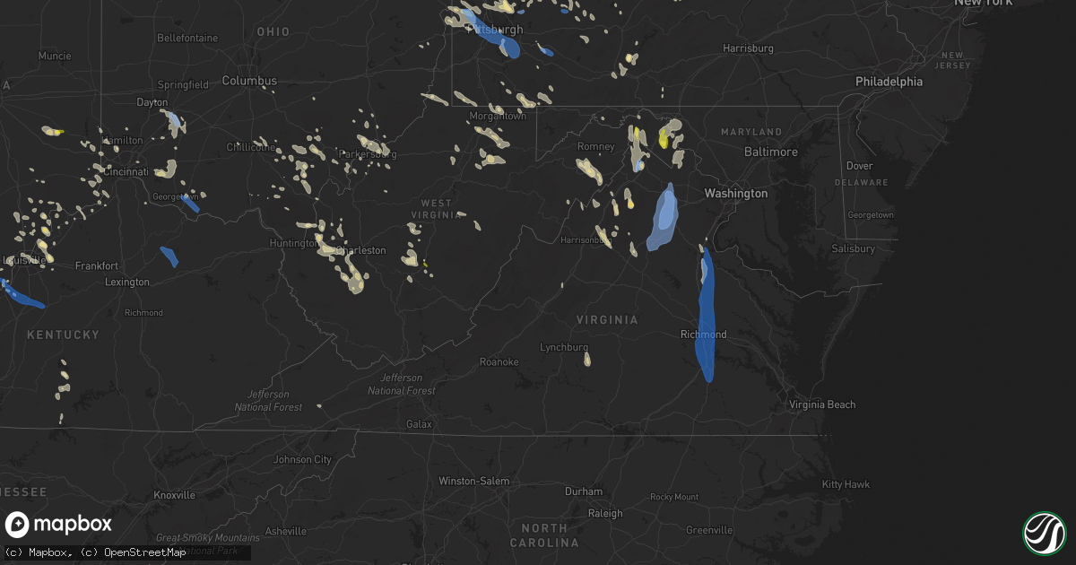
Hail Map in Virginia on June 22, 2022
Get this storm
June 22 map
$229
one time, instant access
Download today. No call, no setup
Keep the $229
Bought the map and want the full workflow? Apply the entire $229 to a subscription within 7 days. None of it is wasted.
Every map, not just this one
This buys you this map. Subscription and you get every map we run, in the markets you choose from a few cities to whole states to nationwide. Plus real-time alerts the moment a storm fires.
Contact data
Name, contact info, occupancy, even credit band for addresses in the footprint. You go from where it hit to who to call.
Become the source they trust
Unlimited branding weather history reports on demand. You already have the documented answer ready for the property owner, and you are the one who showed up with it.
Property data and RoofTrace estimates
Pull up any address you have got, its value and the exact code rules for that jurisdiction, straight from One Click Code. Then RoofTrace estimates the squares, pitch, and roof value, priced the way you price.
Storm reports in Virginia
Virginia
| Date | Description |
|---|---|
| 06/22/20226:59 PM CDT | Winds from a gust front of a thunderstorm blew down several trees near the intersection of maury river road and walkers creek road. |
| 06/22/20226:52 PM CDT | Winds from a gust front of a thunderstorm blew down several trees near the intersection of sterrett road and north lee highway. |
| 06/22/20226:51 PM CDT | Large tree branches down. |
| 06/22/20226:39 PM CDT | Tree down on rt. 727 north... In the vicinity of cub creek rd. |
| 06/22/20226:38 PM CDT | Tree down along red house road near richwood estates rd. |
| 06/22/20226:30 PM CDT | Winds from a gust front of a thunderstorm blew down one tree along the 1700 block of richmond highway and close to riverville road. |
| 06/22/20226:23 PM CDT | Winds from a gust front of a thunderstorm blew down one tree near the intersection of patrick henry highway and turkey mountain road and fletchers level road. |
| 06/22/20226:04 PM CDT | Tree down along w james anderson hwy. |
| 06/22/20226:02 PM CDT | One tree down on us-60 east in the county of buckingham... In the vicinity of alcoma rd. |
| 06/22/20225:58 PM CDT | Tree down on va-20 in the county of buckingham... In the vicinity of copper mine rd. |
| 06/22/20225:33 PM CDT | Numerous trees down across the stanardsville area |
| 06/22/20225:19 PM CDT | Trees down in ivy |
| 06/22/20225:04 PM CDT | Trees blew down near berryville and stringtown... Including along va-611 summit point road. |
| 06/22/20224:39 PM CDT | Tree down across redman store rd just east of buisness us 340 |
| 06/22/20224:34 PM CDT | About a dozen trees down south of st davids church on fort valley road towards the edinburg gap road intersection. |
| 06/22/20224:29 PM CDT | Tree reported down on oak grove road. |
| 06/22/20224:25 PM CDT | A few trees blew down between zeus and brightwood. |
| 06/22/20224:20 PM CDT | A few trees blew down near rapidan. |
| 06/22/20224:18 PM CDT | 3 to 4 trees down. |
| 06/22/20224:11 PM CDT | Tree reported down on ikes crossing lane near us 340. |
| 06/22/20224:10 PM CDT | Tree down across reliance rd at crooked run creek |
| 06/22/20224:05 PM CDT | Trees blew down near the intersection of va-631 marlboro road and va-628 middle road. |
| 06/22/20224:05 PM CDT | Tree down across simmons gap rd near wildview lane |
| 06/22/20224:00 PM CDT | A few trees blew down near white post. |
| 06/22/20224:00 PM CDT | Several trees and wires blew down around culpeper. |
| 06/22/20223:59 PM CDT | Numerous trees down around sperryville. |
| 06/22/20223:57 PM CDT | Tree down across spotswood trail near turkey ridge rd |
| 06/22/20223:55 PM CDT | Several trees and wires blew down around amissville. |
| 06/22/20223:55 PM CDT | Several trees and wires blew down around amissville. |
| 06/22/20223:55 PM CDT | Several trees and wires blew down around rixeyville. |
| 06/22/20223:54 PM CDT | A tree blew down on resettlement rd. |
| 06/22/20223:52 PM CDT | Numerous trees reported down in castleton. |
| 06/22/20223:47 PM CDT | Numerous trees down from 2 miles east of warrenton to opal on rt 29. |
| 06/22/20223:45 PM CDT | Several trees and wires blew down around jeffersonton. |
| 06/22/20223:45 PM CDT | A couple dozen trees and wires blew down across the city of winchester. |
| 06/22/20223:45 PM CDT | Trees and wires blew down in the 2900 block of us-50 northwestern pike. |
| 06/22/20223:40 PM CDT | Hundreds of trees blown down... Many onto homes with at least 3 structure collapses over west-central fauquier county. |
| 06/22/20223:35 PM CDT | Numerous trees blew down blocking us-15/us-29 lee highway between warrenton and new baltimore. |
| 06/22/20223:30 PM CDT | Tree down across shenandoah river rd at jr rd |
| 06/22/20223:30 PM CDT | Numerous trees blew down blocking us-17 winchester road near old tavern. |
| 06/22/20223:30 PM CDT | A local report indicates 62 MPH wind near 2 SW BIG MEADOWS |
| 06/22/20223:25 PM CDT | Dozens of trees blew down along i-66 near marshall. |
| 06/22/20223:23 PM CDT | Several trees down onto powerlines along cobbler mountain rd |
| 06/22/20223:22 PM CDT | Over 200 power outages due to storm in carson. Time estimated from radar. |
| 06/22/20223:20 PM CDT | Several trees blew down along va-649 frogtown road. |
| 06/22/20223:15 PM CDT | Tree down blocking roadway near intersection of n valley pike and llama ln. |
| 06/22/20223:15 PM CDT | Numerous trees and branches down between middleburg and upperville |
| 06/22/20223:15 PM CDT | Trees blew down along va-606 river road near bluemont. |
| 06/22/20223:15 PM CDT | Several trees blew down along va-723 millwood road between boyce and millwood. |
| 06/22/20223:15 PM CDT | Trees down at mm 60 and mm 65 on interstate 85. Time estimated. |
| 06/22/20223:15 PM CDT | A few trees blew down along us-50 john mosby highway near blandy farm. |
| 06/22/20223:14 PM CDT | A tree blew down... Blocking one lane of traffic... On hwy 50 one mile east of boyce. |
| 06/22/20223:14 PM CDT | Nearly 2...000 power outages due to storm. This likely occurred with the passage of the gust front. Time estimated. |
| 06/22/20223:13 PM CDT | Tree down onto road near intersection of n valley pike and endless cavern rd |
| 06/22/20223:12 PM CDT | Several large trees and several powerlines down along st. Louis rd |
| 06/22/20223:10 PM CDT | Trees and wires blew down near the intersection of va-259 maryland road and va-873 wentworth drive. |
| 06/22/20223:10 PM CDT | Trees down on route 460. |
| 06/22/20223:10 PM CDT | Tree down onto powerline near intersection of phillips store rd and mayland rd |
| 06/22/20223:10 PM CDT | A roof was torn from a house on va-619 wampler road near broadway. |
| 06/22/20223:07 PM CDT | Estimated wind gust of at least 50 knots. |
| 06/22/20223:07 PM CDT | Tree down onto road at 3800 block of holsinger rd |
| 06/22/20223:01 PM CDT | Tree down over route 7. |
| 06/22/20222:58 PM CDT | Nearly 4...000 power outages due to storm in petersburg. Time estimated from radar. |
| 06/22/20222:54 PM CDT | Tree fell and punctured the roof of river view on the appomattox health and rehab center. |
| 06/22/20222:54 PM CDT | Multiple trees down near howlett park. Time estimated. |
| 06/22/20222:54 PM CDT | Numerous trees down on woods edge road. Time estimated from radar. |
| 06/22/20222:54 PM CDT | Over 1...200 power outages due to storm just south of bellwood. Time estimated. |
| 06/22/20222:50 PM CDT | Tree down near the intersection of vauxhall and selwood road. Time estimated. |
| 06/22/20222:49 PM CDT | Multiple trees down at richmond highway and terminal avenue. Time estimated from radar. |
| 06/22/20222:45 PM CDT | Tree down on home on swan drive. Time estimated. |
| 06/22/20222:42 PM CDT | Tree down at the intersection of stonewall ave and w 20th street. Time estimated. |
| 06/22/20222:42 PM CDT | Tree fell and smashed into a home. |
| 06/22/20222:35 PM CDT | Numerous trees and wires down in the city of richmond. Time estimated. |
| 06/22/20222:35 PM CDT | Measured 60 mph gust at kric. |
| 06/22/20222:32 PM CDT | Roof ripped off of apartment complex near arthur ashe blvd and broad st. Time estimated. |
| 06/22/20222:32 PM CDT | Report from mping: 3-inch tree limbs broken; power poles broken. Time estimated from radar. |
| 06/22/20222:31 PM CDT | Report from mping: 1-inch tree limbs broken; shingles blown off. |
| 06/22/20222:30 PM CDT | Report from mping: 1-inch tree limbs broken; shingles blown off. |
| 06/22/20222:28 PM CDT | Around 5...000 power outages due to storm between mechanicsville and studley. Time estimated. |
| 06/22/20222:18 PM CDT | Multiple trees down on roadway near the intersection of new ashcake and sliding hill road. Time estimated. |
| 06/22/20222:17 PM CDT | Numerous trees and wires down in ashland. Report from nwschat. Time estimated. |
| 06/22/20222:15 PM CDT | Numerous trees and wires down in hanover courthouse area. Report from nwschat. Time estimated. |
| 06/22/20222:10 PM CDT | Cluster of nearly 1...000 power outages a few miles west of beulahville. Time estimated. |
| 06/22/20222:04 PM CDT | Downed tree blocking jefferson davis highway near hillcrest drive. |
| 06/22/20222:00 PM CDT | Numerous three foot diameter trees were downed between bowling green and carmel church near route 207. One tree was downed on a house roof knocking chimney off. |
| 06/22/20221:55 PM CDT | Around 1...000 power outages clustered just to the west and southwest of bowling green. Time estimated from radar. |
| 06/22/20221:40 PM CDT | Very large tree down blocking the entire road just south of the intersection of woodford road and fredericksburg turnpike. |
| 06/22/20221:40 PM CDT | Large tree down on vehicle on rozell road about one half mile from woodford road. |
| 06/22/20221:40 PM CDT | Large tree down on stonewall jackson road. |
| 06/22/20221:30 PM CDT | Dozens of trees... Large tree limbs... And wires blew down over northeastern spotsylvania county... Including along us-17 mills drive and va-636 mine road. |
| 06/22/20221:24 PM CDT | Reports of large trees snapped... Siding removed... And a shed shifted off its foundation in neighborhoods surrounding maury stadium |
| 06/22/20221:22 PM CDT | Dozens of trees and wires blown down in the city of fredericksburg. |
| 06/22/20221:18 PM CDT | A tree blew down near the 200 block of jett dr. |
| 06/22/20221:13 PM CDT | A local report indicates 62 MPH wind near QUANTICO MARINE CORP |
| 06/22/20221:11 PM CDT | Tree down on kellog mill rd near mountain view rd |
| 06/22/20221:11 PM CDT | Tree down in 700 block of kellog mill rd |
| 06/22/20221:06 PM CDT | Several large trees down near spotter's residence... Causing damage to property. |
| 06/22/20221:06 PM CDT | A tree blew down near the 180 block of ramoth church rd. |
| 06/22/202212:52 PM CDT | One large tree blew down near express dr and dawson beach rd. |
| 06/22/20224:42 AM CDT | At 942 PM EDT, a severe thunderstorm was located near Flat Top, or 9 miles north of Camp Creek, moving southeast at 50 mph. HAZARD...60 mph wind gusts. SOURCE...Radar indicated. IMPACT...Expect damage to roofs, siding, and trees. Locations impacted include... Princeton... Athens... Peterstown... Pipestem... Camp Creek... Oakvale... and Red Sulphur Spring. |
| 06/22/20224:24 AM CDT | At 924 PM EDT, a severe thunderstorm was located near Wise, moving southeast at 30 mph. HAZARD...60 mph wind gusts and penny size hail. SOURCE...Radar indicated. IMPACT...Expect damage to roofs, siding, and trees. Locations impacted include... Norton, Wise, Coeburn and Pound. |
| 06/22/20224:23 AM CDT | At 923 PM EDT, a severe thunderstorm was located near Babcock State Park, moving southeast at 40 mph. HAZARD...60 mph wind gusts. SOURCE...Radar indicated. IMPACT...Expect damage to roofs, siding, and trees. Locations impacted include... Lewisburg... White Sulphur Springs... Ronceverte... Rainelle... Alderson... Rupert... and Union.This includes The following Location The West Virginia StateFairgrounds. |
| 06/22/20223:47 AM CDT | At 846 PM EDT, a severe thunderstorm was located over Slemp, or 11 miles south of Hazard, moving southeast at 30 mph. HAZARD...60 mph wind gusts. SOURCE...Radar indicated. IMPACT...Expect damage to roofs, siding, and trees. This severe thunderstorm will be near... Daisy around 850 PM EDT. Slemp around 855 PM EDT. Delphia around 900 PM EDT.Other locations in the path of this severe thunderstorm includeGordon, Cumberland and Lynch. |
| 06/22/20223:03 AM CDT | At 803 PM EDT, a severe thunderstorm was located over Wren, or near Phenix, moving south at 40 mph. HAZARD...60 mph wind gusts and quarter size hail. SOURCE...Radar indicated. IMPACT...Hail damage to vehicles is expected. Expect wind damage to roofs, siding, and trees. Locations impacted include... South Boston... Halifax... Brookneal... Keysville... Charlotte Court House... Phenix... and Turbeville. |
| 06/22/20222:37 AM CDT | At 737 PM EDT, a severe thunderstorm was located near Stuarts Draft, or 11 miles southwest of Staunton, moving south at 25 mph. HAZARD...60 mph wind gusts and quarter size hail. SOURCE...Radar indicated. IMPACT...Hail damage to vehicles is expected. Expect wind damage to roofs, siding, and trees. Locations impacted include... Buena Vista... Forks Of Buffalo... Cornwall... Lowesville... Alto... Fairfield... and Oronoco. |
| 06/22/20222:29 AM CDT | At 729 PM EDT, a severe thunderstorm was located near Appomattox National Historic Park, or near Appomattox, moving southeast at 30 mph. HAZARD...60 mph wind gusts and quarter size hail. SOURCE...Radar indicated. IMPACT...Hail damage to vehicles is expected. Expect wind damage to roofs, siding, and trees. Locations impacted include... Appomattox... Charlotte Court House... Phenix... Red House... Concord... Pamplin City... and Madisonville. |
| 06/22/20221:39 AM CDT | At 639 PM EDT, a severe thunderstorm was located over Centenary, or 10 miles north of Buckingham, moving south at 65 mph. HAZARD...60 mph wind gusts and quarter size hail. SOURCE...Radar indicated. IMPACT...Hail damage to vehicles is expected. Expect wind damage to roofs, siding, and trees. Locations impacted include... Buckingham... Appomattox... Dillwyn... Phenix... Bent Creek... Pamplin City... and Madisonville. |
| 06/22/20221:20 AM CDT | At 620 PM EDT, a severe thunderstorm was located over Shenandoah, or 14 miles east of Harrisonburg, moving south at 25 mph. HAZARD...60 mph wind gusts and quarter size hail. SOURCE...Radar indicated. IMPACT...Damaging winds will cause some trees and large branches to fall. This could injure those outdoors, as well as damage homes and vehicles. Roadways may become blocked by downed trees. Localized power outages are possible. Unsecured light objects may become projectiles. Locations impacted include... Shenandoah, Massanutten, Stanardsville, Elkton, Mcmullen, Newport, Ingham, Boonesville, Lydia, Haneytown, Mission Home, Swift Run, Amicus, Fletcher, Jollett, Saint George and Shady Grove. |
| 06/22/202212:46 AM CDT | At 545 PM EDT, a severe thunderstorm was located near Louisa, moving south at 45 mph. HAZARD...60 mph wind gusts. SOURCE...Radar indicated. IMPACT...Expect damage to trees and powerlines. This severe thunderstorm will be near... Ferncliff around 555 PM EDT. Kents Store and Troy around 600 PM EDT. Palmyra around 605 PM EDT. Fork Union and Columbia around 615 PM EDT.Other locations impacted by this severe thunderstorm include Dixie,Nahor, Louisa Airport, Green Springs, Stage Junction, Shores, ZionCrossroads, Central Plains, Antioch and Union Mills. |
| 06/22/202212:41 AM CDT | At 540 PM EDT, severe thunderstorms were located along a line extending from near Stanardsville to near Bumpass, moving south at 40 mph. HAZARD...60 mph wind gusts. SOURCE...Radar indicated. IMPACT...Damaging winds will cause some trees and large branches to fall. This could injure those outdoors, as well as damage homes and vehicles. Roadways may become blocked by downed trees. Localized power outages are possible. Unsecured light objects may become projectiles. Locations impacted include... Charlottesville, Orange, Stanardsville, Free Union, Campbell, Westmoreland, Hollymead, Gordonsville, Ruckersville, Ivy, Scottsville, Quinque, North Garden, Eheart, Barboursville, Stony Point, Flordon, Montpelier Station, Newtown and Thornhill. |
| 06/22/202212:35 AM CDT | At 534 PM EDT, a severe thunderstorm was located 7 miles northwest of Luray, or 7 miles south of Woodstock, moving south at 30 mph. HAZARD...60 mph wind gusts and quarter size hail. SOURCE...Radar indicated. IMPACT...Damaging winds will cause some trees and large branches to fall. This could injure those outdoors, as well as damage homes and vehicles. Roadways may become blocked by downed trees. Localized power outages are possible. Unsecured light objects may become projectiles. Locations impacted include... Luray, Stanley, Big Meadows, Edinburg, Alma, Kimball, Honeyville, Ingham, Kings Crossing, Leaksville, Ida, Hamburg, Fairview, Saint Davids Church, Pine Grove and Skyland. |
| 06/22/202212:11 AM CDT | At 511 PM EDT, a severe thunderstorm was located 7 miles southeast of Culpeper, moving south at 40 mph. HAZARD...70 mph wind gusts and quarter size hail. SOURCE...Radar indicated. IMPACT...Damaging winds will cause some trees and large branches to fall. This could injure those outdoors, as well as damage homes and vehicles. Roadways may become blocked by downed trees. Localized power outages are possible. Unsecured light objects may become projectiles. Locations impacted include... Culpeper, Orange, Mine Run, Stevensburg, Oakpark, Everona, Verdiersville, Montpelier Station, Locust Grove, Thornhill, Nasons, Winston, Madison Mills, Montford, Mitchells, Unionville, Somerset, Locust Dale, Raccoon Ford and Rhoadesville. |
| 06/22/202212:08 AM CDT | At 508 PM EDT, a severe thunderstorm was located 9 miles northeast of Luray, or 10 miles southeast of Woodstock, moving south at 30 mph. HAZARD...70 mph wind gusts and quarter size hail. SOURCE...Radar indicated. IMPACT...Damaging winds will cause some trees and large branches to fall. This could injure those outdoors, as well as damage homes and vehicles. Roadways may become blocked by downed trees. Localized power outages are possible. Unsecured light objects may become projectiles. Locations impacted include... Luray, Stanley, Big Meadows, Fairview, Kimball, Bentonville, Compton, Panorama, Ida, Pine Grove, Skyland and Rileyville. |
| 06/21/202211:58 PM CDT | At 457 PM EDT, a severe thunderstorm was located over Stephens City, or near Millwood Pike, moving south at 30 mph. HAZARD...70 mph wind gusts and quarter size hail. SOURCE...Radar indicated. IMPACT...Damaging winds will cause some trees and large branches to fall. This could injure those outdoors, as well as damage homes and vehicles. Roadways may become blocked by downed trees. Localized power outages are possible. Unsecured light objects may become projectiles. Locations impacted include... Winchester, Front Royal, Strasburg, Millwood Pike, Stephens City, Middletown, Fort Valley, Arco, Greenwood, Seven Fountains, Dilbeck, Riverton, Reliance, Armel, Karo, Glen Echo, Nineveh, Cedarville, Buckton and Riverside. |
| 06/21/202211:47 PM CDT | At 447 PM EDT, a severe thunderstorm was located 9 miles southwest of Front Royal, moving southeast at 30 mph. HAZARD...60 mph wind gusts and quarter size hail. SOURCE...Radar indicated. IMPACT...Damaging winds will cause some trees and large branches to fall. This could injure those outdoors, as well as damage homes and vehicles. Roadways may become blocked by downed trees. Localized power outages are possible. Unsecured light objects may become projectiles. Locations impacted include... Karo, Glen Echo, Bentonville, Compton, Seven Fountains, Browntown and Rileyville. |
| 06/21/202211:41 PM CDT | At 440 PM EDT, a severe thunderstorm was located near Hume, or 12 miles southeast of Front Royal, moving southwest at 45 mph. HAZARD...60 mph wind gusts and quarter size hail. SOURCE...Radar indicated. IMPACT...Damaging winds will cause some trees and large branches to fall. This could injure those outdoors, as well as damage homes and vehicles. Roadways may become blocked by downed trees. Localized power outages are possible. Unsecured light objects may become projectiles. Locations impacted include... Sperryville, Flint Hill, Washington, Huntly, Five Forks, Rock Mills, Woodville, Hackleys Crossroads, Fourway and Cresthill. |
| 06/21/202211:39 PM CDT | At 438 PM EDT, a severe thunderstorm was located near Warrenton, moving south at 55 mph. THIS IS A DESTRUCTIVE STORM FOR WARRENTON MOVING SOUTH. HAZARD...80 mph wind gusts and quarter size hail. SOURCE...Radar indicated. IMPACT...Expect considerable damage to trees and power lines. Your life is at significant risk if outdoors. In addition to some trees falling into homes, wind damage is possible to roofs, sheds, open garages, and mobile homes. Locations impacted include... Culpeper, Warrenton, Bealeton, Opal, Remington, Midland, Elkwood, Catalpa, Stevensburg, Brandy Station, Amissville, Jeffersonton, Flat Run, Turnbull, Winston, Cardova, Mitchells, Rixeyville, Lake Of The Woods and Alanthus. |
| 06/21/202211:29 PM CDT | At 429 PM EDT, a severe thunderstorm was located over Shenandoah, or 11 miles east of Harrisonburg, moving southeast at 30 mph. HAZARD...60 mph wind gusts and quarter size hail. SOURCE...Radar indicated. IMPACT...Damaging winds will cause some trees and large branches to fall. This could injure those outdoors, as well as damage homes and vehicles. Roadways may become blocked by downed trees. Localized power outages are possible. Unsecured light objects may become projectiles. Locations impacted include... Shenandoah, Massanutten, Stanardsville, Elkton, Mcmullen, Boonesville, Lydia, Haneytown, Mission Home, Swift Run, Amicus, Saint George and Shady Grove. |
| 06/21/202211:18 PM CDT | At 417 PM EDT, a severe thunderstorm was located near Middleburg, or 14 miles west of Brambleton, moving south at 45 mph. THIS IS A DESTRUCTIVE STORM FOR NEAR MIDDLEBURG MOVING SOUTH TOWARDS MARSHALL. HAZARD...80 mph wind gusts and quarter size hail. SOURCE...Radar indicated. IMPACT...Expect considerable damage to trees and power lines. Your life is at significant risk if outdoors. In addition to some trees falling into homes, wind damage is possible to roofs, sheds, open garages, and mobile homes. Locations impacted include... Warrenton, Middleburg, The Plains, Delaplane, New Baltimore, Marshall, Broken Hill, Auburn, Casanova, Rectortown, Orlean, Meadowville, Halfway, Upperville, Airlie, Broad Run, Ashville and Ada. |
| 06/21/202211:18 PM CDT | At 418 PM EDT, severe thunderstorms were located along a line extending from near Claremont to near Waverly to near Carson to Dinwiddie to 6 miles northwest of Sutherland, moving south at 45 mph. HAZARD...60 mph wind gusts. SOURCE...Radar indicated. IMPACT...Expect damage to trees and powerlines. Severe thunderstorms will be near... Waverly and Stony Creek around 425 PM EDT. Sussex, Elberon and Homeville around 430 PM EDT. Dendron around 435 PM EDT. Wakefield around 440 PM EDT. Emporia, Courtland, Jarratt, Ivor, Sedley, Zuni and Green Plain around 445 PM EDT.Other locations impacted by these severe thunderstorms includeVicksville, Grizzard, Booker, Yale, Lumberton, Wharfs Store, Hilda,Dory, Gwaltney Corner and Story. |
| 06/21/202210:59 PM CDT | At 359 PM EDT, severe thunderstorms were located along a line extending from Jordans Point to Colonial Heights to 8 miles southwest of Chesterfield Court House, moving south at 50 mph. HAZARD...60 mph wind gusts and nickel size hail. SOURCE...Radar indicated. IMPACT...Expect damage to trees and powerlines. Severe thunderstorms will be near... Petersburg and Prince George around 405 PM EDT. Sutherland around 410 PM EDT. Disputanta around 415 PM EDT. Dinwiddie, Carson and Dewitt around 420 PM EDT. McKenney and Stony Creek around 425 PM EDT. Sussex around 430 PM EDT.Other locations impacted by these severe thunderstorms includeNewville, Winterpock, Burgess, Birchett Estate, Addison, Booker,Reams, Jordan Point Country Club, Wharfs Store and PetersburgNational Battlefield. |
| 06/21/202210:27 PM CDT | At 327 PM EDT, severe thunderstorms were located along a line extending from Braddock Heights to near Williamsport, moving south at 35 mph. HAZARD...60 mph wind gusts. SOURCE...Radar indicated. IMPACT...Damaging winds will cause some trees and large branches to fall. This could injure those outdoors, as well as damage homes and vehicles. Roadways may become blocked by downed trees. Localized power outages are possible. Unsecured light objects may become projectiles. Locations impacted include... Martinsburg, Charles Town, Shepherdstown, Brunswick, Ranson, Boonsboro, Wilson-Conococheague, Williamsport, San Mar, Harpers Ferry, Kearneysville, Corporation Of Ranson, Saint James, Berkeley, Halfway, Myersville, Lovettsville, Keedysville, Falling Waters and Sharpsburg. |
| 06/21/202210:08 PM CDT | At 307 PM EDT, severe thunderstorms were located along a line extending from near Mangohick to near Montpelier, moving south at 40 mph. THESE ARE DESTRUCTIVE STORMS FOR THE RICHMOND METRO AND SURROUNDING AREAS. HAZARD...80 mph wind gusts and quarter size hail. SOURCE...Radar indicated. IMPACT...Flying debris will be dangerous to those caught without shelter. Mobile homes will be heavily damaged. Expect considerable damage to roofs, windows, and vehicles. Extensive tree damage and power outages are likely. Severe thunderstorms will be near... Randolph Macon College around 315 PM EDT. Mechanicsville, Wyndham, Studley and Laurel around 325 PM EDT. Richmond, Tuckahoe, East Highland Park and Lakeside around 330 PM EDT. Highland Springs, Virginia Union University, Virginia Commonwealth University and Manakin around 335 PM EDT. Bon Air, University Of Richmond and Downtown Richmond around 340 PM EDT. Bellwood and Bensley around 345 PM EDT. Chester around 350 PM EDT. Moseley around 355 PM EDT.Other locations impacted by these severe thunderstorms includeEnfield, Richmond Heights, Gum Tree, Johnsons Springs, Elmont, EtnaMills, Montrose, Petersburg National Battlefield, Sandston andEpworth. |
| 06/21/20229:53 PM CDT | At 252 PM EDT, a severe thunderstorm was located over Milford, moving south at 45 mph. THIS IS A DESTRUCTIVE STORM FOR HANOVER AND VICINITY! HAZARD...80 mph wind gusts and quarter size hail. SOURCE...Radar indicated. IMPACT...Flying debris will be dangerous to those caught without shelter. Mobile homes will be heavily damaged. Expect considerable damage to roofs, windows, and vehicles. Extensive tree damage and power outages are likely. This severe thunderstorm will be near... Dawn and Kings Dominion around 305 PM EDT. Ashland and Mangohick around 310 PM EDT. Hanover around 315 PM EDT.Other locations impacted by this severe thunderstorm include Calno,Burruss Corner, Globe, Hanover Airport, Doswell, Duane Fork, Penola,Epworth and Etna Mills. |
| 06/21/20229:30 PM CDT | Tree down across peppers ferry road. |
| 06/21/20229:30 PM CDT | Corrects previous tstm wnd dmg report from 3 ene dublin. Tree down across peppers ferry road. |
| 06/21/20229:25 PM CDT | Large limbs blown down off mountain view lane. |
| 06/21/20228:43 PM CDT | Large power outage with over 1000 customers without power near coeburn. |
| 06/21/20228:33 PM CDT | Power outages and trees down area-wide. Larger power outage just to the ne of wise reported as the storm went through. |
| 06/21/20227:41 PM CDT | Tree down along mt. Laurel near green valley rd. |
| 06/21/20227:28 PM CDT | Two trees down on wolf gap road near the wv state line. |
| 06/21/20227:25 PM CDT | One tree down on lennig road. |
| 06/21/20227:03 PM CDT | Tree down along juniper cliff road near hunter road. |
All States Impacted by Hail Map on June 22, 2022
Cities Impacted by Hail Map on June 22, 2022
- Bedford, PA
- Xenia, OH
- Jamestown, OH
- New Lexington, OH
- Somerset, OH
- Blossburg, PA
- Wellsboro, PA
- Clifton Springs, NY
- Shortsville, NY
- Caldwell, OH
- Macksburg, OH
- Dexter City, OH
- Greensburg, PA
- Benezett, PA
- Huntingdon, PA
- State College, PA
- Boalsburg, PA
- Markleysburg, PA
- Palmyra, NY
- Bloomingdale, OH
- Coolville, OH
- Guysville, OH
- Frenchville, PA
- Cumberland, MD
- Oldtown, MD
- Chillicothe, OH
- Philippi, WV
- Lost Creek, WV
- Bridgeport, WV
- Mount Clare, WV
- Brave, PA
- Blacksville, WV
- Spraggs, PA
- Holbrook, PA
- New Freeport, PA
- Aleppo, PA
- Wind Ridge, PA
- West Point, KY
- Cedar Grove, IN
- New Trenton, IN
- West Harrison, IN
- Brookville, IN
- South Webster, OH
- Minford, OH
- Bush, LA
- Covington, LA
- Franklinton, LA
- Cincinnati, OH
- Harrison, OH
- Burkesville, KY
- Henryville, IN
- Memphis, IN
- Borden, IN
- Hopewell, PA
- Saxton, PA
- Woodbury, PA
- Keedysville, MD
- Fairplay, MD
- Sharpsburg, MD
- Shepherdstown, WV
- Falling Waters, WV
- Boonsboro, MD
- Martinsburg, WV
- Kearneysville, WV
- Hagerstown, MD
- Williamsport, MD
- Gerrardstown, WV
- Clear Brook, VA
- Winchester, VA
- Berkeley Springs, WV
- Gore, VA
- Cross Junction, VA
- Stephenson, VA
- Glengary, WV
- Stephens City, VA
- Hedgesville, WV
- Wellington, KS
- Caldwell, KS
- Ray, OH
- South Bloomingville, OH
- McArthur, OH
- Londonderry, OH
- Oregonia, OH
- Clarksville, OH
- Milroy, IN
- Greensburg, IN
- Rushville, IN
- Bloomfield, IN
- Saint Marys, PA
- Hebron, KY
- North Bend, OH
- Addyston, OH
- Cleves, OH
- Latrobe, PA
- Newkirk, OK
- Mineral Wells, WV
- Flemington, WV
- Moatsville, WV
- Luray, VA
- Strasburg, VA
- Rileyville, VA
- Bentonville, VA
- Front Royal, VA
- Fort Valley, VA
- New Washington, IN
- Nabb, IN
- Charlestown, IN
- Westport, KY
- Marysville, IN
- Harpers Ferry, WV
- Shenandoah Junction, WV
- Halstead, KS
- Valley Center, KS
- Sedgwick, KS
- Bentley, KS
- Colwich, KS
- Aurora, IN
- Rising Sun, IN
- Romney, WV
- Shanks, WV
- Bidwell, OH
- Vinton, OH
- Gallipolis, OH
- Ganado, AZ
- Milton, WV
- Glenwood, WV
- Ashton, WV
- Greensburg, KS
- Haviland, KS
- Hickman, KY
- Union City, TN
- Duck, WV
- Nelsonville, OH
- New Marshfield, OH
- Elkton, VA
- Shenandoah, VA
- Harrisonburg, VA
- Broadway, VA
- Fisherville, KY
- Simpsonville, KY
- Patriot, IN
- Martin, TN
- Chester, WV
- Aliquippa, PA
- Oakdale, PA
- New Cumberland, WV
- Burgettstown, PA
- Industry, PA
- Midland, PA
- Hookstown, PA
- Georgetown, PA
- Imperial, PA
- Coraopolis, PA
- McDonald, PA
- Clinton, PA
- New Manchester, WV
- Crescent, PA
- Monaca, PA
- East Liverpool, OH
- Shippingport, PA
- Byrdstown, TN
- Louisville, KY
- Belpre, OH
- Fleming, OH
- Marietta, OH
- Stafford, KS
- Butler, KY
- Foster, KY
- Albany, OH
- Athens, OH
- Mullinville, KS
- Oak Hill, OH
- West Union, OH
- Seaman, OH
- Winchester, OH
- Wilkesville, OH
- Langsville, OH
- Kingman, KS
- Offerle, KS
- Bucklin, KS
- Willcox, AZ
- Warsaw, KY
- Lexington, IN
- Needham, AL
- Goshen, KY
- Crestwood, KY
- Prospect, KY
- Coldwater, KS
- Purgitsville, WV
- Baker, WV
- Rio, WV
- Old Fields, WV
- Moorefield, WV
- Buffalo, WV
- Culloden, WV
- Hamlin, WV
- Hurricane, WV
- Medicine Lodge, KS
- Nashville, KS
- Garden Plain, KS
- Andale, KS
- Newton, KS
- Goddard, KS
- Mount Hope, KS
- Isabel, KS
- Wilmore, KS
- Morgantown, WV
- Maidsville, WV
- Waverly, WV
- Crown City, OH
- Lesage, WV
- Fairfield, OH
- Hamilton, OH
- Batavia, OH
- Williamsburg, OH
- Sylvia, KS
- St John, KS
- Costa, WV
- Ridgeview, WV
- Ashford, WV
- Alum Creek, WV
- Nellis, WV
- Ona, WV
- Summersville, WV
- Drennen, WV
- Haven, KS
- Ebensburg, PA
- Colver, PA
- Cranberry, PA
- Knox, PA
- Waterford, OH
- Stockport, OH
- Adah, PA
- New Salem, PA
- McClellandtown, PA
- Bath, IN
- Oxford, OH
- Glouster, OH
- Griffithsville, WV
- Sod, WV
- Centre Hall, PA
- Bellefonte, PA
- Spivey, KS
- Norwich, KS
- Tornado, WV
- Saint Albans, WV
- Ivydale, WV
- Foster, WV
- Danville, WV
- Madison, WV
- Loysburg, PA
- Mercersburg, PA
- Altoona, PA
- Dysart, PA
- Howard, PA
- Brockport, NY
- Hamlin, NY
- Hilton, NY
- New Bethlehem, PA
- Milesburg, PA
- Okeana, OH
- Weedville, PA
- Lilly, PA
- Cassandra, PA
- Fredericksburg, VA
- Farmington, PA
- Bruceton Mills, WV
- Fairchance, PA
- Gibbon Glade, PA
- Jane Lew, WV
- Salem, WV
- Minneola, KS
- Milton, KY
- Pool, WV
- Quinwood, WV
- Mount Nebo, WV
- Wasco, CA
- Birch Tree, MO
- Winona, MO
- Bloomery, WV
- Great Cacapon, WV
- Greenville, VA
- Milam, WV
- Moundsville, WV
- Glen Easton, WV
- Proctor, WV
- Williamsville, MO
- Plevna, KS
- Dudley, MO
- Elk Horn, KY
- Columbia, KY
- Hacker Valley, WV
- Edinburg, VA
- Lucasville, OH
- Fairmont, WV
- Thornton, WV
- Bedford, KY
- Winfield, WV
- Eleanor, WV
- Scott Depot, WV
- Red House, WV
- Belle Plaine, KS
- Arkansas City, KS
- Oxford, KS
- Geuda Springs, KS
- South Haven, KS
- Honeoye Falls, NY
- Mendon, NY
- Pittsford, NY
- Madison, VA
- Rochelle, VA
- Vienna, WV
- Williamstown, WV
- Parkersburg, WV
- Clay, WV
- Victor, WV
- Swiss, WV
- Seth, WV
- Peytona, WV
- Dayton, PA
- White, PA
- Scottdale, PA
- Acme, PA
- Indiana, PA
- Coudersport, PA
- Markleton, PA
- Confluence, PA
- Lowell, OH
- Beverly, OH
- Jackson, OH
- Wallace, WV
- Clarksburg, WV
- Frankfort, OH
- Lovettsville, VA
- Purcellville, VA
- Charles Town, WV
- Round Hill, VA
- Moores Hill, IN
- Dillsboro, IN
- Elizabeth, IN
- Laconia, IN
- North Vernon, IN
- Scipio, IN
- Westport, IN
- Stafford, VA
- Fulks Run, VA
- Bergton, VA
- Corydon, IN
- Apple Grove, WV
- Fraziers Bottom, WV
- Orgas, WV
- Comfort, WV
- Spout Spring, VA
- Red House, VA
- Appomattox, VA
- Concord, VA
- Addison, PA
- West Hamlin, WV
- Scottown, OH
- Cubero, NM
- Bloomfield, NY
- Victor, NY
- Pittsburgh, PA
- Fallentimber, PA
- Walker, WV
- Newport, OH
- Saint Marys, WV
- Tarentum, PA
- Saxonburg, PA
- Gibsonia, PA
- Russellton, PA
- Valencia, PA
- Cheswick, PA
- Bairdford, PA
- Belleville, WV
- Ravenswood, WV
- Butlerville, IN
- Glassport, PA
- Mckeesport, PA
- Elrama, PA
- Dravosburg, PA
- Clairton, PA
- Webster, PA
- Monongahela, PA
- Finleyville, PA
- West Mifflin, PA
- West Elizabeth, PA
- Belle Vernon, PA
- Elizabeth, PA
- Deputy, IN
- Long Bottom, OH
- Reedsville, OH
- Breeding, KY
- North Newton, KS
- Walton, KS
- Hardtner, KS
- Monterville, WV
- Pickens, WV
- Sardinia, OH
- Madison, IN
- Masonic Home, KY
- New Albany, IN
- Jeffersonville, IN
- Clarksville, IN
- South Charleston, WV
- Georgetown, IN
- Lanesville, IN
- Pratt, KS
- Conway Springs, KS
- Grandin, MO
- Vincent, OH
- Reno, OH
- Ambridge, PA
- Baden, PA
- Beaver, PA
- Freedom, PA
- Sewickley, PA
- Shubuta, MS
- Vossburg, MS
- Vail, AZ
- Elgin, AZ
- Julian, WV
- Alkol, WV
- Yawkey, WV
- Russellville, OH
- Georgetown, OH
- Sanders, KY
- Vevay, IN
- Worthville, KY
- Ghent, KY
- Inman, KS
- Twilight, WV
- Jeffrey, WV
- Racine, WV
- Bob White, WV
- Gordon, WV
- Bim, WV
- Van, WV
- Dexter, KS
- Maple City, KS
- Scottsburg, IN
- Underwood, IN
- Grafton, WV
- Independence, WV
- Homer City, PA
- Penn Run, PA
- Wilmington, OH
- Ford City, PA
- Bulger, PA
- Petersburg, KY
- Hanover, IN
- Kendall, NY
- Holley, NY
- Home, PA
- Clymer, PA
- Marion Center, PA
- Martinsburg, PA
- Lansing, WV
- Lookout, WV
- Edmond, WV
- Waterloo, OH
- Smithfield, PA
- Uniontown, PA
- Masontown, PA
- La Grange, KY
- Newburg, WV
- Farmington, WV
- Barrackville, WV
- Tunnelton, WV
- Pomeroy, OH
- Winfield, KS
- Waterport, NY
- Aroda, VA
- Pratts, VA
- New Middletown, IN
- Murdock, KS
- Bogalusa, LA
- Milan, KS
- Argonia, KS
- Springville, TN
- Buchanan, TN
- Big Sandy, TN
- Pewee Valley, KY
- Maize, KS
- Vandergrift, PA
- Leechburg, PA
- Fort Hill, PA
- Everett, PA
- Creighton, PA
- Bakerstown, PA
- Commodore, PA
- Lost City, WV
- Wardensville, WV
- Hamden, OH
- Kingston, OH
- Woodford, VA
- Glens Fork, KY
- Mayfield, KS
- Trenton, OH
- Gloster, MS
- Anacoco, LA
- Willow Wood, OH
- Hutchinson, KS
- Partridge, KS
- Pickerington, OH
- Carroll, OH
- Adena, OH
- Cadiz, OH
- Rockport, WV
- West College Corner, IN
- Harmony, PA
- Paris Crossing, IN
- Wallback, WV
- Nebo, WV
- Nitro, WV
- Charleston, WV
- Palestine, WV
- Creston, WV
- Leon, WV
- Cranberry Township, PA
- Allison Park, PA
- Mars, PA
- Bradfordwoods, PA
- Wexford, PA
- Natrona Heights, PA
- Sarver, PA
- Warrendale, PA
- Guilford, IN
- Lawrenceburg, IN
- Bellbrook, OH
- Spring Valley, OH
- Port William, OH
- Dayton, OH
- Waynesville, OH
- Owensville, OH
- Fayetteville, OH
- Mount Orab, OH
- Blanchester, OH
- Quicksburg, VA
- Mount Jackson, VA
- Basye, VA
- Turon, KS
- Iuka, KS
- Castlewood, VA
- Lebanon, VA
- Evans City, PA
- Newark, NY
- New Enterprise, PA
- Rochester, NY
- Campbellsburg, KY
- Kittanning, PA
- Worthington, PA
- Midland, OH
- Bradford, PA
- Salamanca, NY
- Woodstock, VA
- Marienville, PA
- Tionesta, PA
- Karthaus, PA
- Canal Winchester, OH
- Leesville, LA
- Elizabeth, WV
- Petroleum, WV
- Mayport, PA
- Punxsutawney, PA
- Timblin, PA
- Kent, NY
- Lebanon, OH
- Poplar Bluff, MO
- Creekside, PA
- Shelocta, PA
- Rural Valley, PA
- Millfield, OH
- Chauncey, OH
- Belva, WV
- Madera, CA
- Cameron, WV
- Clarington, OH
- Powhatan Point, OH
- Parkhill, PA
- Johnstown, PA
- Washington, WV
- Creola, OH
- Zaleski, OH
- New Plymouth, OH
- Stanley, VA
- Carrollton, KY
- Sparta, KY
- Mesquite, NM
- Osage, WV
- Mount Morris, PA
- Dilliner, PA
- Stewart, OH
- Pottersdale, PA
- Freeport, PA
- Whipple, OH
- Lower Salem, OH
- Mannington, WV
- Northern Cambria, PA
- Shade, OH
- Russell Springs, KY
- Puxico, MO
- Wappapello, MO
- Abbyville, KS
- Syria, VA
- Union, KY
- Walton, KY
- Verona, KY
- Vidalia, LA
- Otisco, IN
- Sellersburg, IN
- Peck, KS
- Manchester, OH
- Vanceburg, KY
- Ripley, OH
- Buena Vista, PA
- Yukon, PA
- Herminie, PA
- Smithton, PA
- Bridgeville, PA
- Carnegie, PA
- Homestead, PA
- Greenock, PA
- Presto, PA
- Bethel Park, PA
- South Park, PA
- Lowber, PA
- West Newton, PA
- Duquesne, PA
- Rillton, PA
- McKees Rocks, PA
- Irwin, PA
- Wyano, PA
- Sutersville, PA
- New Kensington, PA
- Ligonier, PA
- Ranson, WV
- Inwood, WV
- Mauckport, IN
- Fort Knox, KY
- Bardstown, KY
- Boston, KY
- Lebanon Junction, KY
- Shepherdsville, KY
- Olympia, KY
- Carlisle, KY
- Sharpsburg, KY
- Moorefield, KY
- Owingsville, KY
- Laurel, IN
- Fort Lee, VA
- Henrico, VA
- Petersburg, VA
- Bowling Green, VA
- Sandston, VA
- Ashland, VA
- Richmond, VA
- Milford, VA
- Mechanicsville, VA
- Ruther Glen, VA
- Prince George, VA
- King George, VA
- Disputanta, VA
- Chesterfield, VA
- Hanover, VA
- Port Royal, VA
- Hopewell, VA
- Colonial Heights, VA
- Chester, VA
- Glen Allen, VA
- Doswell, VA
- Mitchells, VA
- Culpeper, VA
- Elkwood, VA
- Marshall, VA
- Stevensburg, VA
- Reva, VA
- Delaplane, VA
- Brandy Station, VA
- Brightwood, VA
- Hume, VA
- Midland, VA
- Warrenton, VA
- Remington, VA
- Castleton, VA
- The Plains, VA
- Amissville, VA
- Rapidan, VA
- Rixeyville, VA
- Jeffersonton, VA
- Upperville, VA
- Broad Run, VA
- Locust Dale, VA
- Bealeton, VA


