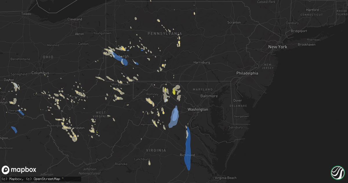
Hail Map on June 22, 2022
Get this storm
June 22 map
$229
one time, instant access
Download today. No call, no setup
Keep the $229
Bought the map and want the full workflow? Apply the entire $229 to a subscription within 7 days. None of it is wasted.
Every map, not just this one
This buys you this map. Subscription and you get every map we run, in the markets you choose from a few cities to whole states to nationwide. Plus real-time alerts the moment a storm fires.
Contact data
Name, contact info, occupancy, even credit band for addresses in the footprint. You go from where it hit to who to call.
Become the source they trust
Unlimited branding weather history reports on demand. You already have the documented answer ready for the property owner, and you are the one who showed up with it.
Property data and RoofTrace estimates
Pull up any address you have got, its value and the exact code rules for that jurisdiction, straight from One Click Code. Then RoofTrace estimates the squares, pitch, and roof value, priced the way you price.
States Impacted by Hail Map on June 22, 2022
Storm reports
Mississippi
| Date | Description |
|---|---|
| 06/22/202212:52 AM CDT | At 551 PM CDT, a severe thunderstorm was located near Bogalusa, moving southwest at 20 mph. HAZARD...60 mph wind gusts and quarter size hail. SOURCE...Radar indicated. IMPACT...Hail damage to vehicles is expected. Expect wind damage to roofs, siding, and trees. Locations impacted include... Bogalusa, Folsom, Sun, Bush and Enon. |
West Virginia
| Date | Description |
|---|---|
| 06/22/20226:58 PM CDT | 2 trees down. |
| 06/22/20226:50 PM CDT | Tree down along o brion road. |
| 06/22/20226:47 PM CDT | Tree down. |
| 06/22/20226:41 PM CDT | A few trees down on horseshoe run road. |
| 06/22/20226:41 PM CDT | Tree down across cumberland rd near potomac ave |
| 06/22/20226:40 PM CDT | Trees reported blown down and one over powerlines along country club road. |
| 06/22/20226:40 PM CDT | Trees snapped or uprooted |
| 06/22/20226:32 PM CDT | Tree fell onto apartment complex. |
| 06/22/20226:32 PM CDT | Tree down blocking road. |
| 06/22/20226:30 PM CDT | Trees reported blown down along chestnut ridge road. |
| 06/22/20226:28 PM CDT | Several trees blown down |
| 06/22/20226:23 PM CDT | Large tree down. Mossman avenue closed. |
| 06/22/20226:20 PM CDT | Tree down on mcmullen hwy near dawson. |
| 06/22/20225:43 PM CDT | Preston county ema reported multiple trees down and a few damaged barns. |
| 06/22/20225:09 PM CDT | Tree down. |
| 06/22/20224:37 PM CDT | Tree down blocking intersection. |
| 06/22/20224:31 PM CDT | Tree down. |
| 06/22/20224:13 PM CDT | Tree down blocking intersection. |
| 06/22/20223:49 PM CDT | A tree blew down near valley rd and fred michael ln. |
| 06/22/20223:38 PM CDT | A few trees blew down near the 2500 block of timber ridge rd. |
| 06/22/20223:25 PM CDT | Numerous trees and wires blew down between charles town and shepherdstown. |
| 06/22/20223:02 PM CDT | Numerous trees and wires blew down near the jefferson/loudoun county line. |
| 06/22/20222:55 PM CDT | Report of damage to trees and penny sized hail near the 470 block of gosling marsh rd. |
| 06/22/20222:55 PM CDT | A local report indicates 1.00 inch wind near 2 E MARTINSBURG |
| 06/22/20222:55 PM CDT | Numerous trees and wires blew down between charles town and shepherdstown. |
| 06/22/20228:42 AM CDT | Multiple trees down between hilldale and talcott. Time estimated from radar. |
| 06/22/20228:35 AM CDT | Trees down along route 20 in hinton. Time estimated from radar. |
| 06/22/20224:10 AM CDT | At 910 PM EDT, a severe thunderstorm was located near Madison, moving southeast at 20 mph. HAZARD...60 mph wind gusts and quarter size hail. SOURCE...Radar indicated. IMPACT...Hail damage to vehicles is expected. Expect wind damage to roofs, siding, and trees. Locations impacted include... Madison, Van, Wharton, Bald Knob, Julian, Amherstdale-Robinette, Danville, Whitesville, Sylvester, Seth, Turtle Creek, Prenter, Woodville, Ashford, Dorothy, Foster, Stickney, Blair, Artie and Sharples.This includes Route 119 between mile markers 46 and 60. |
| 06/22/20223:54 AM CDT | At 854 PM EDT, a severe thunderstorm was located 8 miles northeast of Madison, moving southeast at 15 mph. HAZARD...60 mph wind gusts and quarter size hail. SOURCE...Radar indicated. IMPACT...Hail damage to vehicles is expected. Expect wind damage to roofs, siding, and trees. Locations impacted include... Madison, Marmet, Van, Burnwell, Whitesville, Sylvester, Seth, Leewood, Prenter, Ashford, Eskdale, Foster and Racine.This includes West Virginia Turnpike between mile markers 68 and 70. |
| 06/22/20223:41 AM CDT | At 840 PM EDT, a severe thunderstorm was located over Quinwood, moving southeast at 35 mph. HAZARD...60 mph wind gusts and quarter size hail. SOURCE...Radar indicated. IMPACT...Hail damage to vehicles is expected. Expect wind damage to roofs, siding, and trees. Locations impacted include... Rainelle... Rupert... Quinwood... Bingham... Trout... Williamsburg... and Meadow Bluff. |
| 06/22/20223:31 AM CDT | At 831 PM EDT, a severe thunderstorm was located 7 miles southwest of Summersville, moving southeast at 20 mph. HAZARD...60 mph wind gusts and quarter size hail. SOURCE...Radar indicated. IMPACT...Hail damage to vehicles is expected. Expect wind damage to roofs, siding, and trees. Locations impacted include... Summersville, Kesslers Cross Lanes, Mount Nebo and Drennan. This includes Route 19 between mile markers 25 and 41. |
| 06/22/20223:29 AM CDT | At 829 PM EDT, a severe thunderstorm was located near Culloden, or 7 miles northeast of Hamlin, moving southeast at 20 mph. HAZARD...60 mph wind gusts and quarter size hail. SOURCE...Radar indicated. IMPACT...Hail damage to vehicles is expected. Expect wind damage to roofs, siding, and trees. Locations impacted include... Tornado, Alum Creek, Julian, Griffithsville, Sod, Woodville, Alkol and Yawkey.This includes Route 119 between mile markers 58 and 71. |
| 06/22/20223:16 AM CDT | At 816 PM EDT, a severe thunderstorm was located over Philippi, moving south at 70 mph. HAZARD...60 mph wind gusts and quarter size hail. SOURCE...Radar indicated. IMPACT...Hail damage to vehicles is expected. Expect wind damage to roofs, siding, and trees. Locations impacted include... Grafton, Philippi, Audra State Park, Belington, Flemington, Montrose, Moatsville, Volga, Knottsville, Nestorville, Tygart Lake State Park, Kerens, Galloway and Thornton. |
| 06/22/20223:05 AM CDT | At 805 PM EDT, a severe thunderstorm was located over Milton, or 12 miles north of Hamlin, moving east at 30 mph. HAZARD...60 mph wind gusts and quarter size hail. SOURCE...Radar indicated. IMPACT...Hail damage to vehicles is expected. Expect wind damage to roofs, siding, and trees. Locations impacted include... Nitro, Hurricane, Milton, Poca, Culloden, Teays Valley and Alum Creek.This includes Interstate 64 in West Virginia between mile markers 23and 45. |
| 06/22/20223:02 AM CDT | At 801 PM EDT, a severe thunderstorm was located near Moorefield, moving southeast at 40 mph. HAZARD...60 mph wind gusts and quarter size hail. SOURCE...Radar indicated. IMPACT...Damaging winds will cause some trees and large branches to fall. This could injure those outdoors, as well as damage homes and vehicles. Roadways may become blocked by downed trees. Localized power outages are possible. Unsecured light objects may become projectiles. Locations impacted include... Woodstock, Moorefield, Basye-Bryce Mountain, Mathias, Basye, Edinburg, Orkney Springs, Bean Settlement, Old Fields, Harmony, Mcneill, Perry, Lost City, Lost River, Fisher, Baker, Mount Clifton, Inkerman, Jerome and Mccauley. |
| 06/22/20222:57 AM CDT | At 757 PM EDT, severe thunderstorms were located along a line extending from 8 miles northeast of Terra Alta to near Pleasant Valley, moving southeast at 30 mph. HAZARD...60 mph wind gusts. SOURCE...Radar indicated. IMPACT...Expect damage to trees and power lines, resulting in some power outages. Locations impacted include... Fairmont, Kingwood, Parsons, Terra Alta, Davis, Thomas, Rowlesburg, Pleasant Valley, Newburg, Hendricks, Hambleton, and Reedsville. |
| 06/22/20222:49 AM CDT | At 749 PM EDT, a severe thunderstorm was located near Grafton, moving south at 50 mph. HAZARD...60 mph wind gusts and quarter size hail. SOURCE...Radar indicated. IMPACT...Hail damage to vehicles is expected. Expect wind damage to roofs, siding, and trees. Locations impacted include... Clarksburg, Grafton, Philippi, Bridgeport, Shinnston, Stonewood, Nutter Fort, Lumberport, Anmoore, Enterprise, Flemington, Montrose, Moatsville, Rosemont, Knottsville, Nestorville, Meadland, Tygart Lake State Park, Thornton and McGee.This includes the following highways... Interstate 79 between mile markers 116 and 128. Route 50 in West Virginia between mile markers 77 and 82. |
| 06/22/20222:41 AM CDT | At 740 PM EDT, a severe thunderstorm was located near Belmont, or 7 miles south of St. Marys, moving east at 35 mph. HAZARD...60 mph wind gusts and quarter size hail. SOURCE...Radar indicated. IMPACT...Hail damage to vehicles is expected. Expect wind damage to roofs, siding, and trees. Locations impacted include... Harrisville, Pennsboro, North Bend State Park, Ellenboro, Cairo, Schultz, Pike, Nutter Farm and Highland.This includes Route 50 in West Virginia between mile markers 21 and45. |
| 06/22/20222:38 AM CDT | At 737 PM EDT, a severe thunderstorm was located 7 miles southeast of Big Otter, or 9 miles northeast of Clay, moving southeast at 40 mph. HAZARD...60 mph wind gusts and quarter size hail. SOURCE...Radar indicated. IMPACT...Hail damage to vehicles is expected. Expect wind damage to roofs, siding, and trees. Locations impacted include... Clay, Birch River, Harrison, Widen, Strange Creek, Ivydale and Muddlety.This includes the following highways... Interstate 79 between mile markers 52 and 55. Route 19 between mile markers 47 and 65. |
| 06/22/20222:19 AM CDT | At 719 PM EDT, a severe thunderstorm was located near Boaz, or near Marietta, moving east at 50 mph. HAZARD...60 mph wind gusts and quarter size hail. SOURCE...Radar indicated. IMPACT...Hail damage to vehicles is expected. Expect wind damage to roofs, siding, and trees. Locations impacted include... Parkersburg, Marietta, Belpre, Vienna, Williamstown, Belmont, Boaz, Mineralwells, North Hills, Willow Island, Schultz, Waverly, Fleming and Davisville.This includes the following highways... Interstate 77 in West Virginia between mile markers 171 and 186. Interstate 77 in Ohio between mile markers 1 and 2. Route 50 in West Virginia between mile markers 5 and 23. |
| 06/22/20222:15 AM CDT | At 715 PM EDT, a cluster of severe thunderstorms was centered near Kingwood, moving southeast at 25 mph. HAZARD...60 mph wind gusts. SOURCE...Radar indicated. IMPACT...Expect damage to trees and power lines, resulting in some power outages. Locations impacted include... Kingwood, Terra Alta, Thomas, Rowlesburg, Newburg, Reedsville, Masontown, Albright, Tunnelton, Hannahsville, Valley Point, and Elgon. |
| 06/22/20222:07 AM CDT | At 707 PM EDT, severe thunderstorms were located along a line extending from La Vale to near Kingwood, moving south at 30 mph. HAZARD...60 mph wind gusts and quarter size hail. SOURCE...Radar indicated. IMPACT...Damaging winds will cause some trees and large branches to fall. This could injure those outdoors, as well as damage homes and vehicles. Roadways may become blocked by downed trees. Localized power outages are possible. Unsecured light objects may become projectiles. Locations impacted include... Frostburg, Keyser, Mountain Lake Park, Oakland, Westernport, Bel Air, Bayard, Bittinger, Lonaconing, Piedmont, Loch Lynn Heights, Deer Park, Accident, Elk Garden, Kitzmiller, Cresaptown, Eckhart Mines, Mount Savage, Rawlings and Barton. |
| 06/22/20221:57 AM CDT | At 657 PM EDT, a severe thunderstorm was located 8 miles west of Rutland, moving southeast at 40 mph. HAZARD...60 mph wind gusts and quarter size hail. SOURCE...Radar indicated. IMPACT...Hail damage to vehicles is expected. Expect wind damage to roofs, siding, and trees. Locations impacted include... Point Pleasant, Pomeroy, Racine, Rutland, New Haven, Mason, Middleport, Syracuse, Hartford City, Vinton, Wilkesville, Cheshire, Lakin, Dyesville, Salem Center, Harrisonville, Dexter and Kyger. |
| 06/22/20221:56 AM CDT | At 656 PM EDT, a severe thunderstorm was located 7 miles northeast of Cameron, or 13 miles west of Waynesburg, moving southeast at 30 mph. HAZARD...60 mph wind gusts. SOURCE...Radar indicated. IMPACT...Expect damage to trees and power lines, resulting in some power outages. Locations impacted include... Waynesburg, Cassville, Rogersville, Aleppo, Blacksville, Mount Morris, New Freeport, Spraggs, McCurdyville, Pentress, Wana, and Brave. |
| 06/22/20221:26 AM CDT | At 626 PM EDT, severe thunderstorms were located along a line extending from near Meyersdale to Point Marion, moving southeast at 40 mph. HAZARD...60 mph wind gusts and quarter size hail. SOURCE...Radar indicated. IMPACT...Damaging winds will cause some trees and large branches to fall. This could injure those outdoors, as well as damage homes and vehicles. Roadways may become blocked by downed trees. Localized power outages are possible. Unsecured light objects may become projectiles. Locations impacted include... Frostburg, Mountain Lake Park, Oakland, Westernport, Bel Air, Bayard, Bittinger, La Vale, Lonaconing, Piedmont, Grantsville, Loch Lynn Heights, Friendsville, Deer Park, Accident, Cresaptown, Potomac Park, Eckhart Mines, Mount Savage and Rawlings. |
| 06/22/202212:52 AM CDT | At 552 PM EDT, a severe thunderstorm was located 8 miles southwest of Belmont, or 9 miles east of Parkersburg, moving southeast at 20 mph. HAZARD...60 mph wind gusts and half dollar size hail. SOURCE...Radar indicated. IMPACT...Hail damage to vehicles is expected. Expect wind damage to roofs, siding, and trees. Locations impacted include... North Bend State Park, Ellenboro, Cairo, Schultz, Nutter Farm and Pike.This includes Route 50 in West Virginia between mile markers 17 and36. |
| 06/22/202212:26 AM CDT | At 526 PM EDT, a severe thunderstorm was located near Vienna, or near Belpre, moving southeast at 25 mph. HAZARD...60 mph wind gusts and quarter size hail. SOURCE...Radar indicated. IMPACT...Hail damage to vehicles is expected. Expect wind damage to roofs, siding, and trees. Locations impacted include... Parkersburg, Marietta, Belpre, Vienna, Williamstown, Boaz, North Hills, Waverly, Fleming and Willow Island.This includes the following highways... Interstate 77 in West Virginia between mile markers 173 and 186. Route 50 in West Virginia between mile markers 6 and 17. |
| 06/22/202212:22 AM CDT | At 522 PM EDT, a severe thunderstorm was located over Washington, or near Belpre, moving southeast at 20 mph. HAZARD...60 mph wind gusts and quarter size hail. SOURCE...Radar indicated. IMPACT...Hail damage to vehicles is expected. Expect wind damage to roofs, siding, and trees. Locations impacted include... Parkersburg, Belpre, Lubeck, Washington, Mineralwells, Blennerhassett, Davisville and Little Hocking.This includes the following highways... Interstate 77 in West Virginia between mile markers 164 and 176. Route 50 in West Virginia between mile markers 1 and 15. |
| 06/21/202211:27 PM CDT | At 427 PM EDT, a severe thunderstorm was located near Inwood, or near Greenwood, moving southeast at 35 mph. HAZARD...60 mph wind gusts and quarter size hail. SOURCE...Radar indicated. IMPACT...Damaging winds will cause some trees and large branches to fall. This could injure those outdoors, as well as damage homes and vehicles. Roadways may become blocked by downed trees. Localized power outages are possible. Unsecured light objects may become projectiles. Locations impacted include... Winchester, Millwood Pike, Berryville, Inwood, Cedar Grove, Gaylord, Clear Brook, Ridgeway, Bunker Hill, Oakland, Stephenson, Cedar Hill, Albin, Unger, Stringtown, Brucetown, Glengary, Omps, Greenwood and Shanghai. |
| 06/21/202211:08 PM CDT | At 407 PM EDT, severe thunderstorms were located along a line extending from near Martinsburg to near Oatlands, moving southwest at 30 mph. HAZARD...60 mph wind gusts and quarter size hail. SOURCE...Radar indicated. IMPACT...Damaging winds will cause some trees and large branches to fall. This could injure those outdoors, as well as damage homes and vehicles. Roadways may become blocked by downed trees. Localized power outages are possible. Unsecured light objects may become projectiles. Locations impacted include... Leesburg, Winchester, Martinsburg, Charles Town, Millwood Pike, Purcellville, Ranson, Berryville, Inwood, Middleburg, Round Hill, The Plains, Delaplane, Oatlands, Corporation Of Ranson, Bluemont, Marshall, Boyce, Hamilton and Middleway. |
| 06/21/202210:59 PM CDT | At 359 PM EDT, a severe thunderstorm was located over Chester, or over East Liverpool, moving southeast at 25 mph. HAZARD...60 mph wind gusts. SOURCE...Radar indicated. IMPACT...Expect damage to trees and power lines, resulting in some power outages. Locations impacted include... Weirton, East Liverpool, Wellsville, Calcutta, Ohioville, Chester, Burgettstown, Newell, New Manchester, Georgetown, Hookstown, and Frankfort Springs. |
| 06/21/202210:49 PM CDT | At 348 PM EDT, a severe thunderstorm was located 7 miles northwest of Timberville, or 17 miles north of Harrisonburg, moving southeast at 35 mph. HAZARD...60 mph wind gusts and quarter size hail. SOURCE...Radar indicated. IMPACT...Damaging winds will cause some trees and large branches to fall. This could injure those outdoors, as well as damage homes and vehicles. Roadways may become blocked by downed trees. Localized power outages are possible. Unsecured light objects may become projectiles. Locations impacted include... Harrisonburg, Broadway, Timberville, Shenandoah, Massanutten, Elkton, Tunis, Penn Laird, Yankeetown, Cherry Grove, Lacey Spring, Fulks Run, Singers Glen, Linville, Bergton and Keezletown. |
| 06/21/20229:02 PM CDT | Tree down along pete amos road near rock camp. |
| 06/21/20228:57 PM CDT | Tree down near greenville. |
| 06/21/20228:55 PM CDT | Tree down near bozoo. |
| 06/21/20228:52 PM CDT | Tree down near ballard. |
| 06/21/20228:51 PM CDT | 2 trees down on highway 219 near pickaway. |
| 06/21/20228:42 PM CDT | Corrects previous tstm wnd dmg report from 1 wsw talcott. Multiple trees down between hilldale and talcott. Time estimated from radar. |
| 06/21/20228:35 PM CDT | Corrects previous tstm wnd dmg report from 1 ne hinton. Trees down along route 20 in hinton. Time estimated from radar. |
| 06/21/20228:31 PM CDT | Several trees snapped or blown down near brooks... Along the new river. |
| 06/21/20228:20 PM CDT | Corrects report type of previous flash flood report from 8 ne madison. Multiple trees down along daniel boone parkway in peytona. |
| 06/21/20228:12 PM CDT | Large limbs down along raders valley road. |
| 06/21/20228:10 PM CDT | Trees and power lines down in danville along price branch road. |
| 06/21/20228:10 PM CDT | Trees down along county road 9 from thunderstorm gust-front. |
| 06/21/20228:10 PM CDT | Several trees down in nellis. |
| 06/21/20228:05 PM CDT | Trees down along kieffer road. |
| 06/21/20228:05 PM CDT | Tree down at home in crawley from thunderstorm gust-front. |
| 06/21/20228:01 PM CDT | Tree down along farmdale road from thunderstorm gust-front. |
| 06/21/20227:55 PM CDT | A tree and power lines were blown down. |
| 06/21/20227:50 PM CDT | Multiple trees down in the charmco area. |
| 06/21/20227:44 PM CDT | Tree down near nicholas county line. Time estimated from radar. |
| 06/21/20227:40 PM CDT | Tree blown down near alum creek. |
| 06/21/20227:38 PM CDT | A local report indicates 1.00 inch wind near 6 S SUMMERSVILLE |
| 06/21/20227:30 PM CDT | Multple trees down throughout the city of charleston. A few roads along which trees fell include hickory road... Sissonville drive... Woodbridge drive... Kanawha blvd.. |
| 06/21/20227:22 PM CDT | Multiple trees down along chestnut ridge rd. Time estimated from radar. |
| 06/21/20227:20 PM CDT | Multiple trees down along main street in hurricane. |
| 06/21/20227:10 PM CDT | Tree down along coleman creek rd. Time estimated from radar. |
| 06/21/20227:10 PM CDT | Trees down in ona. |
| 06/21/20227:09 PM CDT | A few trees down on mountaineer highway. |
| 06/21/20227:05 PM CDT | Multiple trees down in grafton along sandy creek road... Haymond road... Plum run road... Yates avenue... And victory avenue. |
| 06/21/20227:00 PM CDT | Tree blown down along irontown road in independence. |
Pennsylvania
| Date | Description |
|---|---|
| 06/22/20226:29 PM CDT | Numerous trees and wires down along route 26. |
| 06/22/20226:21 PM CDT | Trees down on wires. |
| 06/22/20226:19 PM CDT | Trees down on wires. |
| 06/22/20226:03 PM CDT | Numerous trees and wires down along bethel hollow road near the gravity hill. |
| 06/22/20225:46 PM CDT | Trees down on wires northeast of martinsburg. |
| 06/22/20225:42 PM CDT | Trees down on wires. |
| 06/22/20225:42 PM CDT | Numerous trees on wires from south fork to summerhill. |
| 06/22/20225:36 PM CDT | Trees down on wires. |
| 06/22/20225:34 PM CDT | Trees down blocking philippi road at johnson road west of garrett. |
| 06/22/20225:32 PM CDT | Reports of wind-induced power outage |
| 06/22/20225:30 PM CDT | Trees down on wires near ursina. |
| 06/22/20225:06 PM CDT | Tree limbs blown down |
| 06/22/20225:05 PM CDT | Trees blocking route 46 at old creek road. |
| 06/22/20225:00 PM CDT | Trees down on graham and hilltop road |
| 06/22/20225:00 PM CDT | Large tree down blocking roadway on fulton lane |
| 06/22/20225:00 PM CDT | Report of downed light poles. |
| 06/22/20224:48 PM CDT | Report of multiple trees snapped in half. Time estimated based on radar. |
| 06/22/20224:47 PM CDT | Trees down on wires. |
| 06/22/20224:36 PM CDT | Trees down |
| 06/22/20224:35 PM CDT | Trees down on wires across bullitt road. |
| 06/22/20224:30 PM CDT | Report and pictures of multiple trees down and uprooted. Time estimated based on radar. |
| 06/22/20224:30 PM CDT | Report of multiple large tree limbs snapped. Time estimated based on radar. |
| 06/22/20224:30 PM CDT | Tree limbs down. Tree down blocing potato garden run rd. |
| 06/22/20224:29 PM CDT | Trees down |
| 06/22/20224:25 PM CDT | Report of telephone poles snapped... Trees uprooted and snapped. Time estimated based on radar. |
| 06/22/20224:20 PM CDT | Report of large of trees down across unity township. Time estimated based on radar. |
| 06/22/20224:20 PM CDT | A few trees down. |
| 06/22/20224:20 PM CDT | Several large branches and a tree down |
| 06/22/20224:15 PM CDT | Trees down. Time estimate based on radar |
| 06/22/20224:13 PM CDT | Report of tree snapped in half. Time estimated based on radar. |
| 06/22/20224:12 PM CDT | Several trees down |
| 06/22/20224:10 PM CDT | Gas pump blown over |
| 06/22/20224:10 PM CDT | Mobile home roof blew off |
| 06/22/20224:08 PM CDT | Report of large tree limb snapped along bownman avenue. Time estimated based on radar. |
| 06/22/20224:08 PM CDT | Tree down at intersection of 9th / anchor ln |
| 06/22/20224:04 PM CDT | Power lines down |
| 06/22/20224:04 PM CDT | Several trees and wires down |
| 06/22/20224:02 PM CDT | Reports of wind-induced power outage |
| 06/22/20224:01 PM CDT | Large tree limbs down and power poles broken |
| 06/22/20224:01 PM CDT | Power lines down |
| 06/22/20224:01 PM CDT | Power lines down |
| 06/22/20224:00 PM CDT | Large tree limbs down |
| 06/22/20223:58 PM CDT | Several trees down blocking roadway |
| 06/22/20223:58 PM CDT | Report of medium sized tree felled along with other branches broken. Time estimated based on radar. |
| 06/22/20223:57 PM CDT | Tree down in east allegheny |
| 06/22/20223:55 PM CDT | Trees snapped or uprooted |
| 06/22/20223:52 PM CDT | A local report indicates 1.00 inch wind near 4 ENE BOALSBURG |
| 06/22/20223:50 PM CDT | Report of a destroyed swing set in west deer township. Time estimated based on radar. |
| 06/22/20223:50 PM CDT | Trees snapped or uprooted |
| 06/22/20223:50 PM CDT | Trees and wires blocking brush valley road west of centre hall. |
| 06/22/20223:43 PM CDT | Trees down along college ave near the i-99 on ramp. |
| 06/22/20223:40 PM CDT | A few trees down. |
| 06/22/20223:38 PM CDT | Report of tree blocking potato garden run road. Time estimated based on radar. |
| 06/22/20223:34 PM CDT | Multiple large trees down along shafer rd. Near stoops ferry/pa rt 51. Microburst occurred approximately 12 minutes after initial gust front passage... And was accompan |
| 06/22/20223:34 PM CDT | Multiple large trees down |
| 06/22/20223:30 PM CDT | Two large trees down |
| 06/22/20223:28 PM CDT | Reports of numerous trees down and damaged power lines. Time estimated based on radar. |
| 06/22/20223:28 PM CDT | Trees and wires down on bocktown cork road |
| 06/22/20223:25 PM CDT | Report of trees and wires down along kane road. Time estimated based on radar. |
| 06/22/20223:23 PM CDT | Four trees down along laura lane and robin rd. |
| 06/22/20223:22 PM CDT | Large tree blocking roadway |
| 06/22/20223:22 PM CDT | Wires down |
| 06/22/20223:20 PM CDT | Report of numerous trees downa cross lancaster township. Time estimated based on radar. |
| 06/22/20223:15 PM CDT | Power lines down |
| 06/22/20223:12 PM CDT | Trees and wires down on route 150 at deer field lane. |
| 06/22/20223:10 PM CDT | Trees down on woodward ave. |
| 06/22/20221:50 PM CDT | Tree down across road. |
| 06/22/20222:21 AM CDT | At 720 PM EDT, a severe thunderstorm was located over Clearville, moving southeast at 40 mph. HAZARD...60 mph wind gusts and quarter size hail. SOURCE...Radar indicated. IMPACT...Hail damage to vehicles is expected. Expect wind damage to roofs, siding, and trees. Locations impacted include... Bedford, Breezewood, Warfordsburg, Clearville, Everett, Crystal Springs, Needmore, Lake Gordon, Locust Grove, Barnes Gap, Inglesmith and Manns Choice.This includes the following Interstates... Interstate 70 from mile markers 147 to 170. The Pennsylvania Turnpike from mile markers 149 to 165. |
| 06/22/20221:58 AM CDT | At 658 PM EDT, a severe thunderstorm was located near Cameron, or 15 miles southeast of Moundsville, moving southeast at 30 mph. HAZARD...60 mph wind gusts. SOURCE...Radar indicated. IMPACT...Expect damage to trees and power lines, resulting in some power outages. Locations impacted include... Fairmont, Mannington, Barrackville, Cameron, Fairview, Hundred, Grant Town, Farmington, Worthington, New Freeport, McCurdyville, and Burton. |
| 06/22/20221:45 AM CDT | At 645 PM EDT, a severe thunderstorm was located over Ogletown, moving southeast at 40 mph. HAZARD...60 mph wind gusts and quarter size hail. SOURCE...Radar indicated. IMPACT...Hail damage to vehicles is expected. Expect wind damage to roofs, siding, and trees. Locations impacted include... Windber, Bedford, Roaring Spring, New Enterprise, Martinsburg, Everett, Claysburg, Osterburg, Davidsville, Central City, St. Clairsville and Blue Knob State Park.This includes the following Interstates... The Pennsylvania Turnpike between mile markers 132 and 151, and nearmile marker 153. Interstate 99 from mile markers 0 to 23. |
| 06/22/20221:26 AM CDT | At 625 PM EDT, severe thunderstorms were located along a line extending from Northern Cambria to Westmont, moving east at 20 mph. HAZARD...60 mph wind gusts and penny size hail. SOURCE...Radar indicated. IMPACT...Expect damage to roofs, siding, and trees. Locations impacted include... Johnstown, Westmont, Windber, Ebensburg, Belmont, Nanty-Glo, Portage, Northern Cambria, Geistown, Southmont, Patton and Cresson. |
| 06/22/202212:48 AM CDT | At 548 PM EDT, severe thunderstorms were located along a line extending from 6 miles west of Punxsutawney to 6 miles east of Ford City, moving southeast at 35 mph. HAZARD...60 mph wind gusts. SOURCE...Radar indicated. IMPACT...Expect damage to trees and power lines, resulting in some power outages. Locations impacted include... Punxsutawney, Clymer, Rural Valley, Big Run, Dayton, Chevy Chase Heights, Rossiter, Ernest, Marion Center, Cherry Tree, Elderton, and Creekside. |
| 06/22/202212:45 AM CDT | At 545 PM EDT, severe thunderstorms were located along a line extending from Keating Summit to St. Marys, moving southeast at 25 mph. HAZARD...60 mph wind gusts and quarter size hail. SOURCE...Radar indicated. IMPACT...Hail damage to vehicles is expected. Expect wind damage to roofs, siding, and trees. Locations impacted include... St. Marys, Cameron, Wharton, Emporium, Force, Benezette, Stevenson Dam, Elk River, Hicks Run, Keating Summit, Medix Run and Truman. |
| 06/22/202212:40 AM CDT | At 540 PM EDT, severe thunderstorms centered 7 miles southwest of Wintersville, or 9 miles southwest of Steubenville, moving southeast at 30 mph. HAZARD...60 mph wind gusts. SOURCE...Radar indicated. IMPACT...Expect damage to trees and power lines, resulting in some power outages. Locations impacted include... Wheeling, Steubenville, Martins Ferry, Cadiz, Warwood, Wellsburg, Bethlehem, West Liberty, Triadelphia, Clearview, Valley Grove, and Mingo Junction. |
| 06/22/202212:27 AM CDT | At 527 PM EDT, a severe thunderstorm was located over Leechburg, or over Vandergrift, moving southeast at 20 mph. HAZARD...60 mph wind gusts and quarter size hail. SOURCE...Radar indicated. IMPACT...Minor hail damage to vehicles is possible. Expect wind damage to trees and power lines, resulting in some power outages. Locations impacted include... Indiana, Vandergrift, Homer City, Apollo, New Kensington, Lower Burrell, Blairsville, Derry, Leechburg, Black Lick, North Apollo, and West Leechburg. |
| 06/22/202212:13 AM CDT | At 513 PM EDT, severe thunderstorms were located along a line extending from Bald Eagle State Park to Boalsburg, moving southeast at 20 mph. HAZARD...60 mph wind gusts and nickel size hail. SOURCE...Radar indicated. IMPACT...Expect damage to roofs, siding, and trees. Locations impacted include... State College, Lewistown, Bellefonte, Boalsburg, Pleasant Gap, Lemont, Burnham, Zion, Belleville, Houserville, Pine Grove Mills and Milroy.For those driving on Interstate 80, this includes areas between theSnow Shoe and Lamar exits, specifically from mile markers 155 to 166.This includes Interstate 99 from mile markers 74 to 85. |
| 06/22/202212:11 AM CDT | At 510 PM EDT, a severe thunderstorm was located over Lawson Heights, or over Latrobe, moving southeast at 25 mph. HAZARD...60 mph wind gusts. SOURCE...Radar indicated. IMPACT...Expect damage to trees and power lines, resulting in some power outages. Locations impacted include... Greensburg, Latrobe, McChesneytown-Loyalhanna, Derry, Lawson Heights, Ligonier, Seven Springs, Calumet-Norvelt, Youngstown, Laurel Mountain, Donegal, and Champion. |
| 06/22/202212:05 AM CDT | At 505 PM EDT, a severe thunderstorm was located 11 miles southeast of Carrollton, moving southeast at 30 mph. HAZARD...60 mph wind gusts. SOURCE...Radar indicated. IMPACT...Expect damage to trees and power lines, resulting in some power outages. Locations impacted include... Weirton, Steubenville, Wellsburg, Toronto, Wintersville, Mingo Junction, Follansbee, Hooverson Heights, New Cumberland, Salineville, Smithfield, and Franklin. |
| 06/22/202212:03 AM CDT | At 503 PM EDT, a severe thunderstorm was located over Shanor-Northvue, or near Butler, moving southeast at 15 mph. HAZARD...60 mph wind gusts. SOURCE...Radar indicated. IMPACT...Expect damage to trees and power lines, resulting in some power outages. Locations impacted include... Butler, Kittanning, Homeacre-Lyndora, Shanor-Northvue, Meridian, Meadowood, West Kittanning, Chicora, East Butler, Worthington, West Hills, and Applewold. |
| 06/22/202212:02 AM CDT | At 501 PM EDT, severe thunderstorms were centered near Mount Oliver, or over Pittsburgh, moving southeast at 30 mph. HAZARD...60 mph wind gusts. SOURCE...Radar indicated. IMPACT...Expect damage to trees and power lines, resulting in some power outages. Locations impacted include... Pittsburgh, Penn Hills, Mount Lebanon, Bethel Park, Ross Township, McCandless Township, Monroeville, McMurray, Greensburg, McKeesport, Jeannette, and Canonsburg. |
| 06/21/202211:53 PM CDT | At 453 PM EDT, a cluster of severe thunderstorms was centered near Knox, moving southeast at 30 mph. HAZARD...60 mph wind gusts. SOURCE...Radar indicated. IMPACT...Expect damage to trees and power lines, resulting in some power outages. Locations impacted include... Clarion, Brookville, Knox, New Bethlehem, Sligo, Strattanville, Summerville, Limestone, Hawthorn, Shippenville, Corsica, and Callensburg. |
| 06/21/202211:43 PM CDT | At 442 PM EDT, severe thunderstorms centered near Mars, or 8 miles east of Cranberry, are moving southeast at 30 mph. HAZARD...60 mph wind gusts. SOURCE...Radar indicated. IMPACT...Expect damage to trees and power lines, resulting in some power outages. Locations impacted include... Vandergrift, Apollo, Plum, Murrysville, Hampton Township, New Kensington, Lower Burrell, Harrison Township, Arnold, Tarentum, Natrona Heights, and Springdale. |
| 06/21/202211:36 PM CDT | At 436 PM EDT, a severe thunderstorm was located over Centre Hall, moving southeast at 20 mph. HAZARD...60 mph wind gusts and quarter size hail. SOURCE...Radar indicated. IMPACT...Hail damage to vehicles is expected. Expect wind damage to roofs, siding, and trees. Locations impacted include... Lewistown, Bellefonte, Boalsburg, Pleasant Gap, Lemont, Burnham, Zion, Houserville, Milroy, Highland Park, Centre Hall and Milesburg.For those driving on Interstate 80, this includes areas between theSnow Shoe and Lamar exits, specifically from mile markers 157 to 166.This includes Interstate 99 from mile markers 75 to 85. |
| 06/21/202211:26 PM CDT | At 425 PM EDT, a cluster of severes thunderstorm centered over Ambridge, or near Aliquippa, moving southeast at 30 mph. HAZARD...60 mph wind gusts. SOURCE...Radar indicated. IMPACT...Expect damage to trees and power lines, resulting in some power outages. Locations impacted include... Pittsburgh, Penn Hills, Mount Lebanon, Bethel Park, Ross Township, McCandless Township, Cranberry, Moon Township, McMurray, McKeesport, Franklin Park, and Aliquippa. |
| 06/21/202211:19 PM CDT | At 419 PM EDT, a severe thunderstorm was located over Arnot, moving south at 15 mph. HAZARD...60 mph wind gusts and quarter size hail. SOURCE...Radar indicated. IMPACT...Hail damage to vehicles is expected. Expect wind damage to roofs, siding, and trees. Locations impacted include... Blossburg and Arnot. |
| 06/21/202211:15 PM CDT | At 415 PM EDT, a severe thunderstorm was located near Zelienople, or 10 miles north of Cranberry, moving southeast at 20 mph. HAZARD...60 mph wind gusts. SOURCE...Radar indicated. IMPACT...Expect damage to trees and power lines, resulting in some power outages. Locations impacted include... Cranberry, Hampton Township, Homeacre-Lyndora, Meridian, Zelienople, Seven Fields, Gibsonia, Meadowood, Oak Hills, Evans City, Mars, and Saxonburg. |
| 06/21/202211:13 PM CDT | At 413 PM EDT, a severe thunderstorm was located 7 miles east of Tionesta, or 10 miles west of Marienville, moving southeast at 25 mph. HAZARD...60 mph wind gusts. SOURCE...Radar indicated. IMPACT...Expect damage to trees and power lines, resulting in some power outages. Locations impacted include... Marienville, Tionesta, Sigel, Kellettville, Leeper, Clarington, Clear Creek State Park, Cook Forest State Park, and Starr. |
| 06/21/202211:06 PM CDT | At 405 PM EDT, a severe thunderstorm was located over Avis, moving southeast at 20 mph. HAZARD...60 mph wind gusts and nickel size hail. SOURCE...Radar indicated. IMPACT...Expect damage to roofs, siding, and trees. Locations impacted include... Lock Haven, Carroll, Mill Hall, Avis, Dunnstown, Flemington, Castanea, McElhattan, Mackeyville, Loganton and Lock Haven University.For those driving on Interstate 80, this includes areas between theLamar and Mile Run exits, specifically from mile markers 174 to 194. |
| 06/21/202210:42 PM CDT | At 342 PM EDT, a severe thunderstorm was located near East Palestine, moving southeast at 20 mph. HAZARD...60 mph wind gusts. SOURCE...Radar indicated. IMPACT...Expect damage to trees and power lines, resulting in some power outages. Locations impacted include... Aliquippa, Beaver Falls, Monaca, East Palestine, Economy, Ambridge, New Brighton, Beaver, Calcutta, Baden, Rochester, and Ohioville. |
| 06/21/202210:25 PM CDT | At 325 PM EDT, a severe thunderstorm was located over Economy, or near Cranberry, moving southeast at 15 mph. HAZARD...60 mph wind gusts. SOURCE...Radar indicated. IMPACT...Expect damage to trees and power lines, resulting in some power outages. Locations impacted include... Pittsburgh, Penn Hills, Ross Township, McCandless Township, Cranberry, Franklin Park, Shaler Township, Hampton Township, Economy, O'hara Township, Bellevue, and Wexford. |
| 06/21/20229:56 PM CDT | At 255 PM EDT, severe thunderstorms were located along a line extending from near Manchester to Paramount-Long Meadow, moving south at 50 mph. HAZARD...60 mph wind gusts. SOURCE...Radar indicated. IMPACT...Damaging winds will cause some trees and large branches to fall. This could injure those outdoors, as well as damage homes and vehicles. Roadways may become blocked by downed trees. Localized power outages are possible. Unsecured light objects may become projectiles. Locations impacted include... Columbia, Germantown, Frederick, Hagerstown, Olney, Westminster, Damascus, Thurmont, Charles Town, Emmitsburg, Shepherdstown, Municipal Stadium, Harry Grove Stadium, Montgomery Village, Eldersburg, Ballenger Creek, Mount Airy, Robinwood, Taneytown and Brunswick. |
| 06/21/20229:28 PM CDT | At 228 PM EDT, a severe thunderstorm was located over Cashtown, moving south at 40 mph. HAZARD...60 mph wind gusts and nickel size hail. SOURCE...Radar indicated. IMPACT...Expect damage to roofs, siding, and trees. Locations impacted include... Waynesboro, Gettysburg, Carroll Valley, Fayetteville, Wayne Heights, Mont Alto, Scotland, Rouzerville, Cashtown, Orrtanna, Arendtsville and Fairfield.This includes Interstate 81 from mile markers 19 to 27. |
Virginia
| Date | Description |
|---|---|
| 06/22/20226:59 PM CDT | Winds from a gust front of a thunderstorm blew down several trees near the intersection of maury river road and walkers creek road. |
| 06/22/20226:52 PM CDT | Winds from a gust front of a thunderstorm blew down several trees near the intersection of sterrett road and north lee highway. |
| 06/22/20226:51 PM CDT | Large tree branches down. |
| 06/22/20226:39 PM CDT | Tree down on rt. 727 north... In the vicinity of cub creek rd. |
| 06/22/20226:38 PM CDT | Tree down along red house road near richwood estates rd. |
| 06/22/20226:30 PM CDT | Winds from a gust front of a thunderstorm blew down one tree along the 1700 block of richmond highway and close to riverville road. |
| 06/22/20226:23 PM CDT | Winds from a gust front of a thunderstorm blew down one tree near the intersection of patrick henry highway and turkey mountain road and fletchers level road. |
| 06/22/20226:04 PM CDT | Tree down along w james anderson hwy. |
| 06/22/20226:02 PM CDT | One tree down on us-60 east in the county of buckingham... In the vicinity of alcoma rd. |
| 06/22/20225:58 PM CDT | Tree down on va-20 in the county of buckingham... In the vicinity of copper mine rd. |
| 06/22/20225:33 PM CDT | Numerous trees down across the stanardsville area |
| 06/22/20225:19 PM CDT | Trees down in ivy |
| 06/22/20225:04 PM CDT | Trees blew down near berryville and stringtown... Including along va-611 summit point road. |
| 06/22/20224:39 PM CDT | Tree down across redman store rd just east of buisness us 340 |
| 06/22/20224:34 PM CDT | About a dozen trees down south of st davids church on fort valley road towards the edinburg gap road intersection. |
| 06/22/20224:29 PM CDT | Tree reported down on oak grove road. |
| 06/22/20224:25 PM CDT | A few trees blew down between zeus and brightwood. |
| 06/22/20224:20 PM CDT | A few trees blew down near rapidan. |
| 06/22/20224:18 PM CDT | 3 to 4 trees down. |
| 06/22/20224:11 PM CDT | Tree reported down on ikes crossing lane near us 340. |
| 06/22/20224:10 PM CDT | Tree down across reliance rd at crooked run creek |
| 06/22/20224:05 PM CDT | Trees blew down near the intersection of va-631 marlboro road and va-628 middle road. |
| 06/22/20224:05 PM CDT | Tree down across simmons gap rd near wildview lane |
| 06/22/20224:00 PM CDT | A few trees blew down near white post. |
| 06/22/20224:00 PM CDT | Several trees and wires blew down around culpeper. |
| 06/22/20223:59 PM CDT | Numerous trees down around sperryville. |
| 06/22/20223:57 PM CDT | Tree down across spotswood trail near turkey ridge rd |
| 06/22/20223:55 PM CDT | Several trees and wires blew down around rixeyville. |
| 06/22/20223:55 PM CDT | Several trees and wires blew down around amissville. |
| 06/22/20223:55 PM CDT | Several trees and wires blew down around amissville. |
| 06/22/20223:54 PM CDT | A tree blew down on resettlement rd. |
| 06/22/20223:52 PM CDT | Numerous trees reported down in castleton. |
| 06/22/20223:47 PM CDT | Numerous trees down from 2 miles east of warrenton to opal on rt 29. |
| 06/22/20223:45 PM CDT | A couple dozen trees and wires blew down across the city of winchester. |
| 06/22/20223:45 PM CDT | Several trees and wires blew down around jeffersonton. |
| 06/22/20223:45 PM CDT | Trees and wires blew down in the 2900 block of us-50 northwestern pike. |
| 06/22/20223:40 PM CDT | Hundreds of trees blown down... Many onto homes with at least 3 structure collapses over west-central fauquier county. |
| 06/22/20223:35 PM CDT | Numerous trees blew down blocking us-15/us-29 lee highway between warrenton and new baltimore. |
| 06/22/20223:30 PM CDT | Numerous trees blew down blocking us-17 winchester road near old tavern. |
| 06/22/20223:30 PM CDT | A local report indicates 62 MPH wind near 2 SW BIG MEADOWS |
| 06/22/20223:30 PM CDT | Tree down across shenandoah river rd at jr rd |
| 06/22/20223:25 PM CDT | Dozens of trees blew down along i-66 near marshall. |
| 06/22/20223:23 PM CDT | Several trees down onto powerlines along cobbler mountain rd |
| 06/22/20223:22 PM CDT | Over 200 power outages due to storm in carson. Time estimated from radar. |
| 06/22/20223:20 PM CDT | Several trees blew down along va-649 frogtown road. |
| 06/22/20223:15 PM CDT | Tree down blocking roadway near intersection of n valley pike and llama ln. |
| 06/22/20223:15 PM CDT | Trees blew down along va-606 river road near bluemont. |
| 06/22/20223:15 PM CDT | Several trees blew down along va-723 millwood road between boyce and millwood. |
| 06/22/20223:15 PM CDT | Trees down at mm 60 and mm 65 on interstate 85. Time estimated. |
| 06/22/20223:15 PM CDT | A few trees blew down along us-50 john mosby highway near blandy farm. |
| 06/22/20223:15 PM CDT | Numerous trees and branches down between middleburg and upperville |
| 06/22/20223:14 PM CDT | A tree blew down... Blocking one lane of traffic... On hwy 50 one mile east of boyce. |
| 06/22/20223:14 PM CDT | Nearly 2...000 power outages due to storm. This likely occurred with the passage of the gust front. Time estimated. |
| 06/22/20223:13 PM CDT | Tree down onto road near intersection of n valley pike and endless cavern rd |
| 06/22/20223:12 PM CDT | Several large trees and several powerlines down along st. Louis rd |
| 06/22/20223:10 PM CDT | Trees and wires blew down near the intersection of va-259 maryland road and va-873 wentworth drive. |
| 06/22/20223:10 PM CDT | Tree down onto powerline near intersection of phillips store rd and mayland rd |
| 06/22/20223:10 PM CDT | Trees down on route 460. |
| 06/22/20223:10 PM CDT | A roof was torn from a house on va-619 wampler road near broadway. |
| 06/22/20223:07 PM CDT | Estimated wind gust of at least 50 knots. |
| 06/22/20223:07 PM CDT | Tree down onto road at 3800 block of holsinger rd |
| 06/22/20223:01 PM CDT | Tree down over route 7. |
| 06/22/20222:58 PM CDT | Nearly 4...000 power outages due to storm in petersburg. Time estimated from radar. |
| 06/22/20222:54 PM CDT | Tree fell and punctured the roof of river view on the appomattox health and rehab center. |
| 06/22/20222:54 PM CDT | Over 1...200 power outages due to storm just south of bellwood. Time estimated. |
| 06/22/20222:54 PM CDT | Numerous trees down on woods edge road. Time estimated from radar. |
| 06/22/20222:54 PM CDT | Multiple trees down near howlett park. Time estimated. |
| 06/22/20222:50 PM CDT | Tree down near the intersection of vauxhall and selwood road. Time estimated. |
| 06/22/20222:49 PM CDT | Multiple trees down at richmond highway and terminal avenue. Time estimated from radar. |
| 06/22/20222:45 PM CDT | Tree down on home on swan drive. Time estimated. |
| 06/22/20222:42 PM CDT | Tree fell and smashed into a home. |
| 06/22/20222:42 PM CDT | Tree down at the intersection of stonewall ave and w 20th street. Time estimated. |
| 06/22/20222:35 PM CDT | Measured 60 mph gust at kric. |
| 06/22/20222:35 PM CDT | Numerous trees and wires down in the city of richmond. Time estimated. |
| 06/22/20222:32 PM CDT | Roof ripped off of apartment complex near arthur ashe blvd and broad st. Time estimated. |
| 06/22/20222:32 PM CDT | Report from mping: 3-inch tree limbs broken; power poles broken. Time estimated from radar. |
| 06/22/20222:31 PM CDT | Report from mping: 1-inch tree limbs broken; shingles blown off. |
| 06/22/20222:30 PM CDT | Report from mping: 1-inch tree limbs broken; shingles blown off. |
| 06/22/20222:28 PM CDT | Around 5...000 power outages due to storm between mechanicsville and studley. Time estimated. |
| 06/22/20222:18 PM CDT | Multiple trees down on roadway near the intersection of new ashcake and sliding hill road. Time estimated. |
| 06/22/20222:17 PM CDT | Numerous trees and wires down in ashland. Report from nwschat. Time estimated. |
| 06/22/20222:15 PM CDT | Numerous trees and wires down in hanover courthouse area. Report from nwschat. Time estimated. |
| 06/22/20222:10 PM CDT | Cluster of nearly 1...000 power outages a few miles west of beulahville. Time estimated. |
| 06/22/20222:04 PM CDT | Downed tree blocking jefferson davis highway near hillcrest drive. |
| 06/22/20222:00 PM CDT | Numerous three foot diameter trees were downed between bowling green and carmel church near route 207. One tree was downed on a house roof knocking chimney off. |
| 06/22/20221:55 PM CDT | Around 1...000 power outages clustered just to the west and southwest of bowling green. Time estimated from radar. |
| 06/22/20221:40 PM CDT | Very large tree down blocking the entire road just south of the intersection of woodford road and fredericksburg turnpike. |
| 06/22/20221:40 PM CDT | Large tree down on vehicle on rozell road about one half mile from woodford road. |
| 06/22/20221:40 PM CDT | Large tree down on stonewall jackson road. |
| 06/22/20221:30 PM CDT | Dozens of trees... Large tree limbs... And wires blew down over northeastern spotsylvania county... Including along us-17 mills drive and va-636 mine road. |
| 06/22/20221:24 PM CDT | Reports of large trees snapped... Siding removed... And a shed shifted off its foundation in neighborhoods surrounding maury stadium |
| 06/22/20221:22 PM CDT | Dozens of trees and wires blown down in the city of fredericksburg. |
| 06/22/20221:18 PM CDT | A tree blew down near the 200 block of jett dr. |
| 06/22/20221:13 PM CDT | A local report indicates 62 MPH wind near QUANTICO MARINE CORP |
| 06/22/20221:11 PM CDT | Tree down on kellog mill rd near mountain view rd |
| 06/22/20221:11 PM CDT | Tree down in 700 block of kellog mill rd |
| 06/22/20221:06 PM CDT | Several large trees down near spotter's residence... Causing damage to property. |
| 06/22/20221:06 PM CDT | A tree blew down near the 180 block of ramoth church rd. |
| 06/22/202212:52 PM CDT | One large tree blew down near express dr and dawson beach rd. |
| 06/22/20224:42 AM CDT | At 942 PM EDT, a severe thunderstorm was located near Flat Top, or 9 miles north of Camp Creek, moving southeast at 50 mph. HAZARD...60 mph wind gusts. SOURCE...Radar indicated. IMPACT...Expect damage to roofs, siding, and trees. Locations impacted include... Princeton... Athens... Peterstown... Pipestem... Camp Creek... Oakvale... and Red Sulphur Spring. |
| 06/22/20224:24 AM CDT | At 924 PM EDT, a severe thunderstorm was located near Wise, moving southeast at 30 mph. HAZARD...60 mph wind gusts and penny size hail. SOURCE...Radar indicated. IMPACT...Expect damage to roofs, siding, and trees. Locations impacted include... Norton, Wise, Coeburn and Pound. |
| 06/22/20224:23 AM CDT | At 923 PM EDT, a severe thunderstorm was located near Babcock State Park, moving southeast at 40 mph. HAZARD...60 mph wind gusts. SOURCE...Radar indicated. IMPACT...Expect damage to roofs, siding, and trees. Locations impacted include... Lewisburg... White Sulphur Springs... Ronceverte... Rainelle... Alderson... Rupert... and Union.This includes The following Location The West Virginia StateFairgrounds. |
| 06/22/20223:47 AM CDT | At 846 PM EDT, a severe thunderstorm was located over Slemp, or 11 miles south of Hazard, moving southeast at 30 mph. HAZARD...60 mph wind gusts. SOURCE...Radar indicated. IMPACT...Expect damage to roofs, siding, and trees. This severe thunderstorm will be near... Daisy around 850 PM EDT. Slemp around 855 PM EDT. Delphia around 900 PM EDT.Other locations in the path of this severe thunderstorm includeGordon, Cumberland and Lynch. |
| 06/22/20223:03 AM CDT | At 803 PM EDT, a severe thunderstorm was located over Wren, or near Phenix, moving south at 40 mph. HAZARD...60 mph wind gusts and quarter size hail. SOURCE...Radar indicated. IMPACT...Hail damage to vehicles is expected. Expect wind damage to roofs, siding, and trees. Locations impacted include... South Boston... Halifax... Brookneal... Keysville... Charlotte Court House... Phenix... and Turbeville. |
| 06/22/20222:37 AM CDT | At 737 PM EDT, a severe thunderstorm was located near Stuarts Draft, or 11 miles southwest of Staunton, moving south at 25 mph. HAZARD...60 mph wind gusts and quarter size hail. SOURCE...Radar indicated. IMPACT...Hail damage to vehicles is expected. Expect wind damage to roofs, siding, and trees. Locations impacted include... Buena Vista... Forks Of Buffalo... Cornwall... Lowesville... Alto... Fairfield... and Oronoco. |
| 06/22/20222:29 AM CDT | At 729 PM EDT, a severe thunderstorm was located near Appomattox National Historic Park, or near Appomattox, moving southeast at 30 mph. HAZARD...60 mph wind gusts and quarter size hail. SOURCE...Radar indicated. IMPACT...Hail damage to vehicles is expected. Expect wind damage to roofs, siding, and trees. Locations impacted include... Appomattox... Charlotte Court House... Phenix... Red House... Concord... Pamplin City... and Madisonville. |
| 06/22/20221:39 AM CDT | At 639 PM EDT, a severe thunderstorm was located over Centenary, or 10 miles north of Buckingham, moving south at 65 mph. HAZARD...60 mph wind gusts and quarter size hail. SOURCE...Radar indicated. IMPACT...Hail damage to vehicles is expected. Expect wind damage to roofs, siding, and trees. Locations impacted include... Buckingham... Appomattox... Dillwyn... Phenix... Bent Creek... Pamplin City... and Madisonville. |
| 06/22/20221:20 AM CDT | At 620 PM EDT, a severe thunderstorm was located over Shenandoah, or 14 miles east of Harrisonburg, moving south at 25 mph. HAZARD...60 mph wind gusts and quarter size hail. SOURCE...Radar indicated. IMPACT...Damaging winds will cause some trees and large branches to fall. This could injure those outdoors, as well as damage homes and vehicles. Roadways may become blocked by downed trees. Localized power outages are possible. Unsecured light objects may become projectiles. Locations impacted include... Shenandoah, Massanutten, Stanardsville, Elkton, Mcmullen, Newport, Ingham, Boonesville, Lydia, Haneytown, Mission Home, Swift Run, Amicus, Fletcher, Jollett, Saint George and Shady Grove. |
| 06/22/202212:46 AM CDT | At 545 PM EDT, a severe thunderstorm was located near Louisa, moving south at 45 mph. HAZARD...60 mph wind gusts. SOURCE...Radar indicated. IMPACT...Expect damage to trees and powerlines. This severe thunderstorm will be near... Ferncliff around 555 PM EDT. Kents Store and Troy around 600 PM EDT. Palmyra around 605 PM EDT. Fork Union and Columbia around 615 PM EDT.Other locations impacted by this severe thunderstorm include Dixie,Nahor, Louisa Airport, Green Springs, Stage Junction, Shores, ZionCrossroads, Central Plains, Antioch and Union Mills. |
| 06/22/202212:41 AM CDT | At 540 PM EDT, severe thunderstorms were located along a line extending from near Stanardsville to near Bumpass, moving south at 40 mph. HAZARD...60 mph wind gusts. SOURCE...Radar indicated. IMPACT...Damaging winds will cause some trees and large branches to fall. This could injure those outdoors, as well as damage homes and vehicles. Roadways may become blocked by downed trees. Localized power outages are possible. Unsecured light objects may become projectiles. Locations impacted include... Charlottesville, Orange, Stanardsville, Free Union, Campbell, Westmoreland, Hollymead, Gordonsville, Ruckersville, Ivy, Scottsville, Quinque, North Garden, Eheart, Barboursville, Stony Point, Flordon, Montpelier Station, Newtown and Thornhill. |
| 06/22/202212:35 AM CDT | At 534 PM EDT, a severe thunderstorm was located 7 miles northwest of Luray, or 7 miles south of Woodstock, moving south at 30 mph. HAZARD...60 mph wind gusts and quarter size hail. SOURCE...Radar indicated. IMPACT...Damaging winds will cause some trees and large branches to fall. This could injure those outdoors, as well as damage homes and vehicles. Roadways may become blocked by downed trees. Localized power outages are possible. Unsecured light objects may become projectiles. Locations impacted include... Luray, Stanley, Big Meadows, Edinburg, Alma, Kimball, Honeyville, Ingham, Kings Crossing, Leaksville, Ida, Hamburg, Fairview, Saint Davids Church, Pine Grove and Skyland. |
| 06/22/202212:11 AM CDT | At 511 PM EDT, a severe thunderstorm was located 7 miles southeast of Culpeper, moving south at 40 mph. HAZARD...70 mph wind gusts and quarter size hail. SOURCE...Radar indicated. IMPACT...Damaging winds will cause some trees and large branches to fall. This could injure those outdoors, as well as damage homes and vehicles. Roadways may become blocked by downed trees. Localized power outages are possible. Unsecured light objects may become projectiles. Locations impacted include... Culpeper, Orange, Mine Run, Stevensburg, Oakpark, Everona, Verdiersville, Montpelier Station, Locust Grove, Thornhill, Nasons, Winston, Madison Mills, Montford, Mitchells, Unionville, Somerset, Locust Dale, Raccoon Ford and Rhoadesville. |
| 06/22/202212:08 AM CDT | At 508 PM EDT, a severe thunderstorm was located 9 miles northeast of Luray, or 10 miles southeast of Woodstock, moving south at 30 mph. HAZARD...70 mph wind gusts and quarter size hail. SOURCE...Radar indicated. IMPACT...Damaging winds will cause some trees and large branches to fall. This could injure those outdoors, as well as damage homes and vehicles. Roadways may become blocked by downed trees. Localized power outages are possible. Unsecured light objects may become projectiles. Locations impacted include... Luray, Stanley, Big Meadows, Fairview, Kimball, Bentonville, Compton, Panorama, Ida, Pine Grove, Skyland and Rileyville. |
| 06/21/202211:58 PM CDT | At 457 PM EDT, a severe thunderstorm was located over Stephens City, or near Millwood Pike, moving south at 30 mph. HAZARD...70 mph wind gusts and quarter size hail. SOURCE...Radar indicated. IMPACT...Damaging winds will cause some trees and large branches to fall. This could injure those outdoors, as well as damage homes and vehicles. Roadways may become blocked by downed trees. Localized power outages are possible. Unsecured light objects may become projectiles. Locations impacted include... Winchester, Front Royal, Strasburg, Millwood Pike, Stephens City, Middletown, Fort Valley, Arco, Greenwood, Seven Fountains, Dilbeck, Riverton, Reliance, Armel, Karo, Glen Echo, Nineveh, Cedarville, Buckton and Riverside. |
| 06/21/202211:47 PM CDT | At 447 PM EDT, a severe thunderstorm was located 9 miles southwest of Front Royal, moving southeast at 30 mph. HAZARD...60 mph wind gusts and quarter size hail. SOURCE...Radar indicated. IMPACT...Damaging winds will cause some trees and large branches to fall. This could injure those outdoors, as well as damage homes and vehicles. Roadways may become blocked by downed trees. Localized power outages are possible. Unsecured light objects may become projectiles. Locations impacted include... Karo, Glen Echo, Bentonville, Compton, Seven Fountains, Browntown and Rileyville. |
| 06/21/202211:41 PM CDT | At 440 PM EDT, a severe thunderstorm was located near Hume, or 12 miles southeast of Front Royal, moving southwest at 45 mph. HAZARD...60 mph wind gusts and quarter size hail. SOURCE...Radar indicated. IMPACT...Damaging winds will cause some trees and large branches to fall. This could injure those outdoors, as well as damage homes and vehicles. Roadways may become blocked by downed trees. Localized power outages are possible. Unsecured light objects may become projectiles. Locations impacted include... Sperryville, Flint Hill, Washington, Huntly, Five Forks, Rock Mills, Woodville, Hackleys Crossroads, Fourway and Cresthill. |
| 06/21/202211:39 PM CDT | At 438 PM EDT, a severe thunderstorm was located near Warrenton, moving south at 55 mph. THIS IS A DESTRUCTIVE STORM FOR WARRENTON MOVING SOUTH. HAZARD...80 mph wind gusts and quarter size hail. SOURCE...Radar indicated. IMPACT...Expect considerable damage to trees and power lines. Your life is at significant risk if outdoors. In addition to some trees falling into homes, wind damage is possible to roofs, sheds, open garages, and mobile homes. Locations impacted include... Culpeper, Warrenton, Bealeton, Opal, Remington, Midland, Elkwood, Catalpa, Stevensburg, Brandy Station, Amissville, Jeffersonton, Flat Run, Turnbull, Winston, Cardova, Mitchells, Rixeyville, Lake Of The Woods and Alanthus. |
| 06/21/202211:29 PM CDT | At 429 PM EDT, a severe thunderstorm was located over Shenandoah, or 11 miles east of Harrisonburg, moving southeast at 30 mph. HAZARD...60 mph wind gusts and quarter size hail. SOURCE...Radar indicated. IMPACT...Damaging winds will cause some trees and large branches to fall. This could injure those outdoors, as well as damage homes and vehicles. Roadways may become blocked by downed trees. Localized power outages are possible. Unsecured light objects may become projectiles. Locations impacted include... Shenandoah, Massanutten, Stanardsville, Elkton, Mcmullen, Boonesville, Lydia, Haneytown, Mission Home, Swift Run, Amicus, Saint George and Shady Grove. |
| 06/21/202211:18 PM CDT | At 417 PM EDT, a severe thunderstorm was located near Middleburg, or 14 miles west of Brambleton, moving south at 45 mph. THIS IS A DESTRUCTIVE STORM FOR NEAR MIDDLEBURG MOVING SOUTH TOWARDS MARSHALL. HAZARD...80 mph wind gusts and quarter size hail. SOURCE...Radar indicated. IMPACT...Expect considerable damage to trees and power lines. Your life is at significant risk if outdoors. In addition to some trees falling into homes, wind damage is possible to roofs, sheds, open garages, and mobile homes. Locations impacted include... Warrenton, Middleburg, The Plains, Delaplane, New Baltimore, Marshall, Broken Hill, Auburn, Casanova, Rectortown, Orlean, Meadowville, Halfway, Upperville, Airlie, Broad Run, Ashville and Ada. |
| 06/21/202211:18 PM CDT | At 418 PM EDT, severe thunderstorms were located along a line extending from near Claremont to near Waverly to near Carson to Dinwiddie to 6 miles northwest of Sutherland, moving south at 45 mph. HAZARD...60 mph wind gusts. SOURCE...Radar indicated. IMPACT...Expect damage to trees and powerlines. Severe thunderstorms will be near... Waverly and Stony Creek around 425 PM EDT. Sussex, Elberon and Homeville around 430 PM EDT. Dendron around 435 PM EDT. Wakefield around 440 PM EDT. Emporia, Courtland, Jarratt, Ivor, Sedley, Zuni and Green Plain around 445 PM EDT.Other locations impacted by these severe thunderstorms includeVicksville, Grizzard, Booker, Yale, Lumberton, Wharfs Store, Hilda,Dory, Gwaltney Corner and Story. |
| 06/21/202210:59 PM CDT | At 359 PM EDT, severe thunderstorms were located along a line extending from Jordans Point to Colonial Heights to 8 miles southwest of Chesterfield Court House, moving south at 50 mph. HAZARD...60 mph wind gusts and nickel size hail. SOURCE...Radar indicated. IMPACT...Expect damage to trees and powerlines. Severe thunderstorms will be near... Petersburg and Prince George around 405 PM EDT. Sutherland around 410 PM EDT. Disputanta around 415 PM EDT. Dinwiddie, Carson and Dewitt around 420 PM EDT. McKenney and Stony Creek around 425 PM EDT. Sussex around 430 PM EDT.Other locations impacted by these severe thunderstorms includeNewville, Winterpock, Burgess, Birchett Estate, Addison, Booker,Reams, Jordan Point Country Club, Wharfs Store and PetersburgNational Battlefield. |
| 06/21/202210:27 PM CDT | At 327 PM EDT, severe thunderstorms were located along a line extending from Braddock Heights to near Williamsport, moving south at 35 mph. HAZARD...60 mph wind gusts. SOURCE...Radar indicated. IMPACT...Damaging winds will cause some trees and large branches to fall. This could injure those outdoors, as well as damage homes and vehicles. Roadways may become blocked by downed trees. Localized power outages are possible. Unsecured light objects may become projectiles. Locations impacted include... Martinsburg, Charles Town, Shepherdstown, Brunswick, Ranson, Boonsboro, Wilson-Conococheague, Williamsport, San Mar, Harpers Ferry, Kearneysville, Corporation Of Ranson, Saint James, Berkeley, Halfway, Myersville, Lovettsville, Keedysville, Falling Waters and Sharpsburg. |
| 06/21/202210:08 PM CDT | At 307 PM EDT, severe thunderstorms were located along a line extending from near Mangohick to near Montpelier, moving south at 40 mph. THESE ARE DESTRUCTIVE STORMS FOR THE RICHMOND METRO AND SURROUNDING AREAS. HAZARD...80 mph wind gusts and quarter size hail. SOURCE...Radar indicated. IMPACT...Flying debris will be dangerous to those caught without shelter. Mobile homes will be heavily damaged. Expect considerable damage to roofs, windows, and vehicles. Extensive tree damage and power outages are likely. Severe thunderstorms will be near... Randolph Macon College around 315 PM EDT. Mechanicsville, Wyndham, Studley and Laurel around 325 PM EDT. Richmond, Tuckahoe, East Highland Park and Lakeside around 330 PM EDT. Highland Springs, Virginia Union University, Virginia Commonwealth University and Manakin around 335 PM EDT. Bon Air, University Of Richmond and Downtown Richmond around 340 PM EDT. Bellwood and Bensley around 345 PM EDT. Chester around 350 PM EDT. Moseley around 355 PM EDT.Other locations impacted by these severe thunderstorms includeEnfield, Richmond Heights, Gum Tree, Johnsons Springs, Elmont, EtnaMills, Montrose, Petersburg National Battlefield, Sandston andEpworth. |
| 06/21/20229:53 PM CDT | At 252 PM EDT, a severe thunderstorm was located over Milford, moving south at 45 mph. THIS IS A DESTRUCTIVE STORM FOR HANOVER AND VICINITY! HAZARD...80 mph wind gusts and quarter size hail. SOURCE...Radar indicated. IMPACT...Flying debris will be dangerous to those caught without shelter. Mobile homes will be heavily damaged. Expect considerable damage to roofs, windows, and vehicles. Extensive tree damage and power outages are likely. This severe thunderstorm will be near... Dawn and Kings Dominion around 305 PM EDT. Ashland and Mangohick around 310 PM EDT. Hanover around 315 PM EDT.Other locations impacted by this severe thunderstorm include Calno,Burruss Corner, Globe, Hanover Airport, Doswell, Duane Fork, Penola,Epworth and Etna Mills. |
| 06/21/20229:30 PM CDT | Corrects previous tstm wnd dmg report from 3 ene dublin. Tree down across peppers ferry road. |
| 06/21/20229:30 PM CDT | Tree down across peppers ferry road. |
| 06/21/20229:25 PM CDT | Large limbs blown down off mountain view lane. |
| 06/21/20228:43 PM CDT | Large power outage with over 1000 customers without power near coeburn. |
| 06/21/20228:33 PM CDT | Power outages and trees down area-wide. Larger power outage just to the ne of wise reported as the storm went through. |
| 06/21/20227:41 PM CDT | Tree down along mt. Laurel near green valley rd. |
| 06/21/20227:28 PM CDT | Two trees down on wolf gap road near the wv state line. |
| 06/21/20227:25 PM CDT | One tree down on lennig road. |
| 06/21/20227:03 PM CDT | Tree down along juniper cliff road near hunter road. |
Kentucky
| Date | Description |
|---|---|
| 06/22/20226:43 PM CDT | Branch fell on camper...two people inside were extricated by ems. Unknown if any injuries. Also...one tree down in town. |
| 06/22/20226:40 PM CDT | Tree down on hwy 1000. |
| 06/22/20226:35 PM CDT | Tree down on hwy 191. |
| 06/22/20226:28 PM CDT | A large tree limb was blown down onto stamper branch. |
| 06/22/20226:15 PM CDT | Trees down. |
| 06/22/20226:12 PM CDT | Received report on social media of four trees down and blocking the road near exit 48 on the mountain parkway. Time estimated from radar. |
| 06/22/20226:12 PM CDT | Report from 911 dispatch stating a tree was down on calaboose ridge road. Time estimated from radar. |
| 06/22/20226:10 PM CDT | Corrects previous tstm wnd dmg report from 2 se stanton. Tree reported down at the 2000 block of furnace road in stanton... Ky. Time estimated via radar. |
| 06/22/20226:08 PM CDT | Report from 911 dispatch stating a tree came down on hiram branch road. The tree fell on a power line... Taking out power to nearby customers. Time estimated from radar |
| 06/22/20226:08 PM CDT | Received report from 911 dispatch stating multiple trees were down on glencarin road in rogers... Ky. Time estimated from radar. |
| 06/22/20226:08 PM CDT | Power lines down. |
| 06/22/20226:07 PM CDT | Tree down. |
| 06/22/20226:06 PM CDT | Tree reported down near the 1900 block of pilot road in stanton... Ky. Time estimated via radar. |
| 06/22/20226:00 PM CDT | Tree reported down on ky-60 just outside salt lick. |
| 06/22/20225:55 PM CDT | Tree reported down along ky-111. |
| 06/22/20225:35 PM CDT | Tree reported down at the intersection of stepstone and turley road. |
| 06/22/20225:35 PM CDT | A tree was reported down at 1342 indian mound drive. The tree fell on an electric line... But power was not out. Time estimated from radar and observation in mount ster |
| 06/22/20225:35 PM CDT | Tree reported down on 1675 fogg pike. |
| 06/22/20225:35 PM CDT | Tree reported down at the intersection of step and wires down along route 26. |
| 06/22/20225:30 PM CDT | Report of a few large tree limbs removed along ky-11 near mm 1. Time estimated from radar. |
| 06/22/20225:30 PM CDT | Tree reported down on 210 rogers avenue. |
| 06/22/20225:30 PM CDT | Tree reported down at the intersection of howards mill road and stepstone mill road. |
| 06/22/20225:30 PM CDT | 911 center reported a tree was down on levee road bypass. The tree was on an electric line but power did not go out. Time estimated from radar and observation in mount |
| 06/22/20225:25 PM CDT | Multiple trees reported down at 3991 grassy lick road. |
| 06/22/20225:25 PM CDT | Tree reported down at the intersection of midland trail and hinkston pike. |
| 06/22/20225:25 PM CDT | Multiple trees reported down at 3298 prewitt-grassy lick road. |
| 06/22/20225:20 PM CDT | Several trees down in the tollesboro area. Time estimated by radar. |
| 06/22/20225:06 PM CDT | Trees down on bethany rd. |
| 06/22/20225:05 PM CDT | Tree down on e union rd. Stone and turley road. |
| 06/22/20225:05 PM CDT | Tree down on e union rd. |
| 06/22/20225:00 PM CDT | Several trees down... Blocking multiple roads in mason county. This includes clarks run... Kentucky route 8 and parker road. Time estimated from radar to be between 555 |
| 06/22/20224:55 PM CDT | Tree down on clear creek rd. |
| 06/22/20224:55 PM CDT | Tree down at shadynook pike and shaw ln. |
| 06/22/20224:55 PM CDT | Tress down on delaney ferry rd. |
| 06/22/20224:55 PM CDT | A few trees were downed along state route 10. Time estimated by radar. |
| 06/22/20224:53 PM CDT | Tree down on 62e. |
| 06/22/20224:45 PM CDT | Tree down on state hwy 1284 w. |
| 06/22/20224:40 PM CDT | Tree down on ky hwy 1032 w. |
| 06/22/20224:30 PM CDT | Several trees down throughout pendleton county. Time estimated by radar to have occured between 525 pm and 535 pm. |
| 06/22/20224:30 PM CDT | Trees down on back creek rd. |
| 06/22/20224:30 PM CDT | A few trees were downed along state route 8. Time estimated by radar. |
| 06/22/20224:17 PM CDT | Trees down at cropper rd and eminence pike. |
| 06/22/20224:17 PM CDT | Trees down at cropper rd and eminence pike. |
| 06/22/20224:15 PM CDT | Trees down on fox run rd. |
| 06/22/20224:09 PM CDT | Portion of roof removed from a distillery building. Time estimated based on radar. |
| 06/22/20224:05 PM CDT | Trees in power lines on buck creek rd. |
| 06/22/20224:05 PM CDT | Trees in power lines on todds point rd. |
| 06/22/20223:50 PM CDT | A few trees down in the warsaw area. Time estimated by radar. |
| 06/22/20223:50 PM CDT | Report of a tree down across hudson lane near st. Gabriel church. Time estimated from radar. |
| 06/22/20223:35 PM CDT | Trees down on i-71s at exit 2 onto zorn avenue and on the va hospital property. |
| 06/22/20223:32 PM CDT | Report of trees and power lines down along bluegrass parkway. Time estimated from radar. |
| 06/22/20223:30 PM CDT | Tree down on house. |
| 06/22/20223:27 PM CDT | Numerous trees down across the county |
| 06/22/20223:27 PM CDT | Trees down on grinstead dr near i-64. |
| 06/22/20223:26 PM CDT | Barn roof peeled off. |
| 06/22/20223:25 PM CDT | Trees and powerlines down on the 5300 block of w hwy 524. |
| 06/22/20223:21 PM CDT | Two trees down... One on a house and another on a car |
| 06/22/20223:15 PM CDT | Trees down on rose island rd. |
| 06/22/20223:27 AM CDT | At 827 PM EDT, a severe thunderstorm was located over Toulouse, or near Hyden, moving southeast at 35 mph. HAZARD...60 mph wind gusts and penny size hail. SOURCE...Radar indicated. IMPACT...Expect damage to roofs, siding, and trees. This severe thunderstorm will be near... Avawam around 830 PM EDT. Frew around 835 PM EDT. Daley around 840 PM EDT. Viper around 845 PM EDT.Other locations in the path of this severe thunderstorm include Daisyand Slemp. |
| 06/22/20222:20 AM CDT | At 720 PM EDT, severe thunderstorms were located along a line extending from Lenox to Trent, moving east at 40 mph. HAZARD...60 mph wind gusts. SOURCE...Radar indicated. IMPACT...Expect damage to roofs, siding, and trees. Severe thunderstorms will be near... Elamton around 725 PM EDT. Silverhill around 730 PM EDT. Burkhart around 735 PM EDT. Dale around 740 PM EDT.Other locations in the path of these severe thunderstorms includeEugene. |
| 06/22/20222:07 AM CDT | At 706 PM CDT, severe thunderstorms were from 7 miles east of Burkesville to 7 miles northeast of Celina, moving southeast at 15 mph. HAZARD...60 mph wind gusts and nickel size hail. SOURCE...Radar indicated. IMPACT...Expect damage to roofs, siding, and trees. Locations impacted include... Albany, Littrell, Snow, Savage, Highway, Ida, Modoc, Green Grove, Rolan, and Decide. |
| 06/22/20221:59 AM CDT | At 658 PM EDT, a severe thunderstorm was located over Fagan, or near Frenchburg, moving east at 35 mph. HAZARD...60 mph wind gusts. SOURCE...Radar indicated. IMPACT...Expect damage to roofs, siding, and trees. This severe thunderstorm will be near... Frenchburg around 710 PM EDT. Denniston around 715 PM EDT.Other locations in the path of this severe thunderstorm includeWellington, Ebon and Kellacey. |
| 06/22/20221:42 AM CDT | At 642 PM EDT, a severe thunderstorm was located 7 miles north of Boone, moving southeast at 30 mph. HAZARD...60 mph wind gusts and nickel size hail. SOURCE...Radar indicated. IMPACT...Expect damage to roofs, siding, and trees. Locations impacted include... Richmond, Berea, Silver Creek, Caleast, Duluth, Peytontown, Bighill, Kingston, Whites, and Buggytown. |
| 06/22/20221:34 AM CDT | At 633 PM CDT, severe thunderstorms were from 8 miles northwest of Jamestown to 13 miles northwest of Cabell to near Burkesville, moving southeast at 25 mph.Trees and power lines were reported down with these storms in Adair County. HAZARD...60 mph wind gusts and quarter size hail. SOURCE...Radar indicated. IMPACT...Hail damage to vehicles is expected. Expect wind damage to roofs, siding, and trees. Locations impacted include... Jamestown, Burkesville, Russell Springs, Desda, Eli, Snow, Cundiff, Ida, Royville, and Sano. |
| 06/22/20221:21 AM CDT | At 620 PM EDT, a severe thunderstorm was located over Carlisle, or 16 miles north of Mount Sterling, moving southeast at 20 mph. HAZARD...60 mph wind gusts. SOURCE...Radar indicated. IMPACT...Expect damage to roofs, siding, and trees. This severe thunderstorm will be near... Sharpsburg around 640 PM EDT.Other locations in the path of this severe thunderstorm includeStoops and Flat Creek. |
| 06/22/20221:18 AM CDT | At 618 PM EDT, a severe thunderstorm was located over Clarktown, moving southeast at 30 mph. HAZARD...60 mph wind gusts and penny size hail. SOURCE...Radar indicated. IMPACT...Expect damage to trees and power lines. Locations impacted include... Portsmouth, Wheelersburg, New Boston, South Webster, Rosemount, Clarktown, Lucasville, Sciotodale, Portsmouth Regional Airport, Minford, Lyra and Sciotoville. |
| 06/22/20221:14 AM CDT | At 614 PM EDT, severe thunderstorms were located from 10 miles north of Rome to Maysville, moving southeast at 20 mph. HAZARD...60 mph wind gusts. SOURCE...Radar indicated. IMPACT...Expect damage to trees and power lines. Locations impacted include... Maysville, Washington, Manchester, Vanceburg, Tollesboro, Rome, Blue Creek, Concord, Trinity, Saint Paul, Rectorville, Epworth, Ribolt, Friendship, Charters, Sandy Springs, Buena Vista in Scioto County, Firebrick, Carrs and State Route 348 at State Route 125. |
| 06/22/20221:08 AM CDT | At 607 PM CDT, severe thunderstorms were from 12 miles southeast of Campbellsville to 10 miles east of Edmonton, moving southeast at 20 mph. HAZARD...60 mph wind gusts and quarter size hail. SOURCE...Radar indicated. IMPACT...Hail damage to vehicles is expected. Expect wind damage to roofs, siding, and trees. Locations impacted include... Columbia, Christine, Cundiff, Gadberry, Absher, Sano, Bliss, Fairplay, Flatwood and Gentrys Mill. |
| 06/22/202212:59 AM CDT | At 559 PM EDT, severe thunderstorms were located along a line extending from Aberdeen to 6 miles east of Cynthiana, moving southeast at 45 mph. HAZARD...60 mph wind gusts and penny size hail. SOURCE...Radar indicated. IMPACT...Expect damage to roofs, siding, and trees. These severe thunderstorms will remain over mainly rural areas of northern Fleming County, including the following locations... Ewing. |
| 06/22/202212:56 AM CDT | At 556 PM EDT, a severe thunderstorm was located 9 miles northeast of Cynthiana, moving southeast at 45 mph. HAZARD...60 mph wind gusts and penny size hail. SOURCE...Radar indicated. IMPACT...Expect damage to roofs, siding, and trees. Locations impacted include... Carlisle, Jackstown, Oddville, Ellisville, Pleasant Valley, Headquarters, Claysville, Moorefield, Myers, and Barefoot. |
| 06/22/202212:49 AM CDT | At 549 PM EDT, severe thunderstorms were located along a line extending from 10 miles south of Lawrenceburg to 12 miles southeast of Taylorsville, moving southeast at 25 mph. HAZARD...60 mph wind gusts and quarter size hail. SOURCE...Radar indicated. IMPACT...Hail damage to vehicles is expected. Expect wind damage to roofs, siding, and trees. Locations impacted include... Harrodsburg, Ballard, Burgin, Willisburg, Mackville, Tablow, Dugansville, Talmage, Cornishville, and Riverview Estates. |
| 06/22/202212:45 AM CDT | At 545 PM EDT, severe thunderstorms were located from 7 miles southeast of Brooksville to 10 miles northeast of Cynthiana, moving southeast at 25 mph. HAZARD...60 mph wind gusts. SOURCE...Radar indicated. IMPACT...Expect damage to trees and power lines. Locations impacted include... Lewisburg, Mount Olivet, Sardis, US Route 62 at State Route 875, Blue Licks Battlefield, Abigail, Murphysville, Burika, Alhambra, Stonewall, Mays Lick, Mitchells Mill, Santa Fe, Peed, Fleming-Mason Airport, Lowell, Helena, Kentontown, Piqua and US Route 62 at State Route 616. |
| 06/22/202212:40 AM CDT | At 539 PM EDT, a severe thunderstorm was located near Mount Orab, moving southeast at 25 mph. HAZARD...60 mph wind gusts. SOURCE...Radar indicated. IMPACT...Expect damage to trees and power lines. Locations impacted include... Maysville, Georgetown, Mount Orab, West Union, Ripley, Aberdeen, Sardinia, Decatur, Russellville, Hamersville, Dover, Redoak, Moranburg, Lake Waynoka, Bradysville, Bentonville, South Ripley, Tuckahoe, New Hope and Locust Ridge. |
| 06/22/202212:34 AM CDT | At 533 PM EDT, a severe thunderstorm was located near Falmouth, moving southeast at 35 mph. HAZARD...60 mph wind gusts and quarter size hail. SOURCE...Radar indicated. IMPACT...Hail damage to vehicles is expected. Expect wind damage to roofs, siding, and trees. Locations impacted include... Cynthiana, Berry, Robinson, Colemansville, Oddville, Boyd, Claysville, Antioch, Garnett, and Kelat. |
| 06/21/202211:59 PM CDT | At 459 PM EDT, severe thunderstorms were located along a line extending from near Middletown to Pioneer Village to near Shepherdsville, moving east at 25 mph. HAZARD...60 mph wind gusts and penny size hail. SOURCE...Radar indicated. IMPACT...Expect damage to roofs, siding, and trees. Locations impacted include... Jeffersontown, Shepherdsville, Pioneer Village, Hollow Creek, Hollyvilla, Spring Mill, Highview, Fern Creek, Okolona and Minor Lane Heights. |
| 06/21/202211:46 PM CDT | At 445 PM EDT, severe thunderstorms were from near Bedford to La Grange to near Middletown, moving southeast at 15 mph. HAZARD...60 mph wind gusts and nickel size hail. SOURCE...Radar indicated. IMPACT...Expect damage to roofs, siding, and trees. Locations impacted include... Shelbyville, La Grange, Middletown, New Castle, Pendleton, Crestwood, Eminence, Simpsonville, Pewee Valley and Campbellsburg. |
| 06/21/202211:36 PM CDT | At 436 PM EDT, a severe thunderstorm was located near Vevay, moving east at 30 mph. HAZARD...60 mph wind gusts. SOURCE...Radar indicated. IMPACT...Expect damage to trees and power lines. Locations impacted include... Vevay, Warsaw, Florence, Kentucky Speedway, Glencoe, Ghent, Sanders, Sparta, Ethridge, Munk, Interstate 71 at Mile Marker 52, Interstate 71 at US Route 127, Markland, Eagle Hill, Napoleon, Twin Bridges, Needmore, Holbrook, US Route 42 at State Route 184 and Elliston.This includes I-71 in Kentucky between mile markers 50 and 67. |
| 06/21/202211:14 PM CDT | At 414 PM EDT, a severe thunderstorm was located over Harrison, moving southeast at 20 mph. HAZARD...60 mph wind gusts and quarter size hail. SOURCE...Radar indicated. IMPACT...Minor hail damage to vehicles is possible. Expect wind damage to trees and power lines. Locations impacted include... Cincinnati, Harrison, Cheviot, Cleves, Shawnee, Taylor Creek, Bridgetown, Delhi Township, Miami Heights, Blue Jay, University of Cincinnati, Monfort Heights, Mack, Delhi Hills, New Haven, Grandview, Addyston, North Bend, West Harrison and Dent.This includes the following Interstates... I-71 in Ohio between mile markers 3 and 4. I-74 in Ohio between mile markers 1 and 19. I-75 in Ohio between mile markers 2 and 6. |
| 06/21/202210:54 PM CDT | At 353 PM EDT, severe thunderstorms were from near Scottsburg to 14 miles northwest of Prospect to 12 miles northwest of New Albany, moving east at 20 mph. HAZARD...60 mph wind gusts and quarter size hail. SOURCE...Radar indicated. IMPACT...Hail damage to vehicles is expected. Expect wind damage to roofs, siding, and trees. Locations impacted include... New Albany, Clarksville, Charlestown, Sellersburg, Lexington, Owen, Borden, Saint Joseph, Henryville, and Starlight. |
| 06/21/202210:50 PM CDT | At 350 PM EDT, a severe thunderstorm was located 7 miles southwest of Madison, moving southeast at 25 mph. HAZARD...60 mph wind gusts and quarter size hail. SOURCE...Radar indicated. IMPACT...Hail damage to vehicles is expected. Expect wind damage to roofs, siding, and trees. Locations impacted include... Bedford, Hanover, Saluda, Bethlehem, Milton, Monitor, Otto, Trout, Paynesville, and Hanover Beach. |
| 06/21/20229:33 PM CDT | Tree reported down at the 2000 block of furnace road in stanton... Ky. Time estimated via radar. |
| 06/21/20228:05 PM CDT | Tree fell on a house on parker street. |
| 06/21/20227:45 PM CDT | Tree down on right fork maces creek road. |
| 06/21/20227:45 PM CDT | Tree down on ky-7. Time estimated by radar. |
| 06/21/20227:40 PM CDT | Powerline down near the dollar general on cutshin road. Power outages have been reported throughout the surrounding area. |
| 06/21/20227:10 PM CDT | Tree down on bowlin road. |
Missouri
| Date | Description |
|---|---|
| 06/22/20227:39 AM CDT | At 1239 AM CDT, severe thunderstorms were located along a line extending from 7 miles north of Keytesville to near Salisbury to near Fayette, moving east at 20 mph. HAZARD...60 mph wind gusts. SOURCE...Radar indicated. IMPACT...Expect damage to roofs, siding, and trees. Locations impacted include... Moberly, Salisbury, Huntsville, Higbee, Keytesville, Clark, Callao, Cairo, Armstrong, Renick, Jacksonville, Clifton Hill, Prairie Hill and Wien. |
| 06/21/202210:13 PM CDT | At 312 PM CDT, a severe thunderstorm was located near Lake Wappapello State Park, and is nearly stationary. HAZARD...60 mph wind gusts and quarter size hail. SOURCE...Radar indicated. IMPACT...Hail damage to vehicles is expected. Expect wind damage to roofs, siding, and trees. Locations impacted include... Lake Wappapello State Park and Wappapello. |
| 06/21/20229:51 PM CDT | At 250 PM CDT, a severe thunderstorm was located near Lake Wappapello State Park, moving southeast at 5 mph. HAZARD...60 mph wind gusts. SOURCE...Radar indicated. IMPACT...Expect damage to roofs, siding, and trees. Locations impacted include... Lake Wappapello State Park and Wappapello. |
| 06/21/20228:53 PM CDT | At 153 PM CDT, a severe thunderstorm was located near Winona, or 19 miles east of Mountain View, moving east at 15 mph. HAZARD...60 mph wind gusts and quarter size hail. SOURCE...Radar indicated. IMPACT...Hail damage to vehicles is expected. Expect wind damage to roofs, siding, and trees. Locations impacted include... Winona... Greer... |
California
| Date | Description |
|---|---|
| 06/22/20225:53 PM CDT | Wind gust to 69mph measured in moore... Ca. |
| 06/22/20227:44 AM CDT | At 1242 AM PDT Doppler radar indicated a severe thunderstorm capable of producing damaging winds in excess of 60 mph. This storm was located over Mount Wilson and was moving northwest at 25 mph. Penny size hail may also accompany the damaging winds. Locations impacted include... Mount Wilson... Monrovia... Angeles Crest Highway between Mount Wilson and Mount Waterman... Sierra Madre... Arcadia... and Duarte. |
| 06/22/20225:29 AM CDT | At 1028 PM PDT, a severe thunderstorm was located over Parksdale, or over Madera, moving northwest at 10 mph. HAZARD...60 mph wind gusts and penny size hail. SOURCE...Radar indicated. IMPACT...Expect damage to roofs, siding, and trees. Locations impacted include... Madera, Chowchilla, Parkwood, Parksdale, Bonadelle Ranchos-Madera Ranchos and Madera Acres. |
| 06/22/20223:29 AM CDT | At 828 PM PDT, severe thunderstorms were located along a line extending from 13 miles southwest of Los Banos to 18 miles east of Ridgemark, moving northwest at 10 mph. HAZARD...60 mph wind gusts and quarter size hail. SOURCE...Radar indicated. IMPACT...Hail damage to vehicles is expected. Expect wind damage to roofs, siding, and trees. These severe thunderstorms will remain over mainly rural areas of southwestern Merced County. |
| 06/22/20222:13 AM CDT | At 713 PM PDT, a severe thunderstorm was located 14 miles west of Coalinga, or 36 miles north of Paso Robles, and is nearly stationary. HAZARD...60 mph wind gusts and quarter size hail. SOURCE...Radar indicated. IMPACT...Hail damage to vehicles is expected. Expect wind damage to roofs, siding, and trees. This severe thunderstorm will remain over mainly rural areas of southwestern Fresno County. |
| 06/22/202212:00 AM CDT | At 459 PM PDT, a severe thunderstorm was located over Hwy 78 Between Borrego Springs Rd And Ocotillo Wells, moving north at 25 mph. HAZARD...60 mph wind gusts and frequent lightning strikes. SOURCE...Radar indicated. IMPACT...Expect damage to roofs, siding, and trees. Locations impacted include... Hwy 78 Between Borrego Springs Rd And Ocotillo Wells, Borrego Springs, Hwy 78 Between S2 And Borrego Springs Rd, Hwy S22 Between Borrego Springs And Imperial County Line, Ocotillo Wells, Thermal, La Quinta, Mecca, Ocotillo Wells Vehicular Rec Area and Santa Rosa Mountain. |
| 06/21/202211:27 PM CDT | Correct mesonet station is pcec1. |
| 06/21/202211:27 PM CDT | Mesonet station pece1. |
| 06/21/202211:25 PM CDT | At 425 PM PDT, a severe thunderstorm was located over Borrego Palm Canyon, or 7 miles northwest of Borrego Springs, moving north at 25 mph. HAZARD...60 mph wind gusts and quarter size hail. SOURCE...Radar indicated. IMPACT...Hail damage to vehicles is expected. Expect wind damage to roofs, siding, and trees. Locations impacted include... Southeastern Palm Springs, northern Borrego Springs, eastern Anza, Borrego Palm Canyon, Hwy 74 Between Anza And Palm Desert, Hwy 74 Between Mountain Center And Anza, La Quinta, Santa Rosa Mountain and Los Coyotes Indian Reservation. |
| 06/21/202210:45 PM CDT | At 344 AM PDT, a severe thunderstorm was located 13 miles east of McFarland, or 15 miles east of Delano, moving north at 30 mph. HAZARD...Quarter size hail. SOURCE...Radar indicated. IMPACT...Damage to vehicles is expected. Locations impacted include... Ducor, Richgrove and Fountain Springs. |
| 06/21/20228:10 PM CDT | At 110 AM PDT, a severe thunderstorm was located 9 miles northeast of Mount Wilson, moving north at 15 mph. HAZARD...60 mph wind gusts and penny size hail. SOURCE...Radar indicated. IMPACT...Expect damage to roofs, siding, and trees. Locations impacted include... Pearblossom... Llano... Valyermo... and Angeles Crest Highway between Mount Wilson and Mount Waterman. |
Ohio
| Date | Description |
|---|---|
| 06/22/20226:35 PM CDT | Tree down. |
| 06/22/20225:45 PM CDT | Tree down. |
| 06/22/20225:42 PM CDT | A few trees down along careys run road. Time estimated by radar. |
| 06/22/20225:37 PM CDT | Tree down. |
| 06/22/20225:35 PM CDT | Tree down. |
| 06/22/20225:33 PM CDT | 5 trees down in the area. |
| 06/22/20225:30 PM CDT | Corrects previous tornado report from 3 ne albany. Person who submitted the report confirmed that all trees were laying in the same direction. Reports of severe damage |
| 06/22/20225:27 PM CDT | 5 trees down in the area. |
| 06/22/20225:27 PM CDT | Tree down. |
| 06/22/20225:27 PM CDT | Tree down. |
| 06/22/20225:27 PM CDT | Tree down. |
| 06/22/20225:20 PM CDT | A few trees were downed along blue run township road. Time estimated by radar. |
| 06/22/20225:20 PM CDT | Tree down. |
| 06/22/20225:16 PM CDT | A few trees down along thomas hollow road. Time estimated rom radar. |
| 06/22/20225:06 PM CDT | Tree down. |
| 06/22/20224:50 PM CDT | A couple of trees down on wires in the georgetown area.time estimated by radar. |
| 06/22/20224:48 PM CDT | A tree was downed along russellville-winchester road. Time estimated from radar. |
| 06/22/20224:10 PM CDT | A few trees down across northern fairfield county. Time estimated by radar. |
| 06/22/20224:06 PM CDT | Tree reported down on secondary road. |
| 06/22/20224:05 PM CDT | Tree down at intersection. |
| 06/22/20223:50 PM CDT | Large tree limbs down |
| 06/22/20223:27 PM CDT | Erroneous report from a previous day regarding damage in reading |
| 06/22/20223:27 PM CDT | Several large trees down at saints peter and paul cemetery in reading. Via social media |
| 06/22/20223:27 PM CDT | A few trees were downed in whitewater township. Time estimated by radar. |
| 06/22/20223:22 PM CDT | Report of trees down in the area. Time estiamted based on radar. |
| 06/22/20223:13 PM CDT | Large branhes down on wires. Time estimated by radar. |
| 06/22/20223:13 PM CDT | Two large healthy tree branches reported down. Branches fell on wooden fence causing damage. Time estimated from radar. |
| 06/22/20223:05 PM CDT | Report of multiple trees down. Time estimated based on radar. |
| 06/22/20223:03 PM CDT | Several trees down in ross township along hamilton cleves road. Time estimated by radar. |
| 06/22/20223:00 PM CDT | A tree was doen on jack road near the intersection of phillips road. Time estimated from radar. |
| 06/22/20223:00 PM CDT | A large tree fell through the top of a park building. Time estimated by radar. |
| 06/22/20222:35 PM CDT | Numerous trees down across southern green county. Time estimated from radar to be from 335 pm until about 345 pm. |
| 06/22/20222:35 PM CDT | Trees down near the intersection of us35 and sr380. Time estimated from radar. |
| 06/22/20222:27 PM CDT | Some large branches and a small tree were downed near the intesection of hewitt avenue and whipp road. Time estimated by radar. |
| 06/22/20222:45 AM CDT | At 745 PM EDT, a severe thunderstorm was located 11 miles north of Ona, or 11 miles northeast of Proctorville, moving east at 30 mph. HAZARD...60 mph wind gusts and quarter size hail. SOURCE...Radar indicated. IMPACT...Hail damage to vehicles is expected. Expect wind damage to roofs, siding, and trees. Locations impacted include... Winfield, Hurricane, Milton, Eleanor, Buffalo, Teays Valley, Culloden, Crown City, Athalia, Scottown, Ashton, Green Bottom and Fraziers Bottom.This includes Interstate 64 in West Virginia between mile markers 27and 29, and between mile markers 31 and 39. |
| 06/22/20221:52 AM CDT | At 652 PM EDT, severe thunderstorms were located along a line extending from near Clarktown to Stoops, moving south at 45 mph. HAZARD...60 mph wind gusts. SOURCE...Radar indicated. IMPACT...Expect damage to roofs, siding, and trees. Locations impacted include... Ashland, Ironton, Grayson, Gallipolis, Coal Grove, Olive Hill, Oak Hill, Rio Grande, Cannonsburg, Lake Vesuvius, Grayson Lake State Park, Carter Caves State Park, Greenup, Coalton, Denton, Gesling, Greenbo Lake, Oldtown, Load and Letitia.This includes Interstate 64 in Kentucky between mile markers 149 and184. |
| 06/22/20221:45 AM CDT | At 644 PM EDT, a severe thunderstorm was located 10 miles north of Marietta, moving southeast at 25 mph. HAZARD...60 mph wind gusts and quarter size hail. SOURCE...Radar indicated. IMPACT...Hail damage to vehicles is expected. Expect wind damage to roofs, siding, and trees. Locations impacted include... Marietta, Macksburg, Lower Salem and Devola. This includes Interstate 77 in Ohio between mile markers 3 and 17. |
| 06/22/20221:42 AM CDT | At 642 PM EDT, a severe thunderstorm was located near Athens, moving southeast at 25 mph. HAZARD...60 mph wind gusts and quarter size hail. SOURCE...Radar indicated. IMPACT...Hail damage to vehicles is expected. Expect wind damage to roofs, siding, and trees. Locations impacted include... Athens. |
| 06/22/20221:35 AM CDT | At 634 PM EDT, severe thunderstorms were located from 6 miles southwest of Rosemount to near Vanceburg to near Foxport, moving east at 20 mph. HAZARD...60 mph wind gusts. SOURCE...Radar indicated. IMPACT...Expect damage to trees and power lines. Locations impacted include... Portsmouth, Wheelersburg, New Boston, Vanceburg, Head of Grassy, Rosemount, Camp Dix, Franklin Furnace, Sciotodale, Saint Paul, Kinniconick, Friendship, Petersville, Stricklett, Rexton, Sandy Springs, Buena Vista in Scioto County, Firebrick, West Portsmouth and Harris. |
| 06/22/20221:23 AM CDT | At 623 PM EDT, a cluster of severe thunderstorms was centered near Powhatan Point, or 9 miles south of Moundsville, moving southeast at 30 mph. HAZARD...60 mph wind gusts. SOURCE...Radar indicated. IMPACT...Expect damage to trees and power lines, resulting in some power outages. Locations impacted include... Moundsville, New Martinsville, Shadyside, Powhatan Point, Glen Dale, Pine Grove, Hundred, Jacksonburg, Clarington, Smithfield, Cameron, and New Freeport. |
| 06/22/20221:23 AM CDT | At 623 PM EDT, severe thunderstorms were located along a line extending from near Lake Hope State Park to 9 miles east of Waverly, moving southeast at 35 mph. HAZARD...60 mph wind gusts and quarter size hail. SOURCE...Radar indicated. IMPACT...Hail damage to vehicles is expected. Expect wind damage to roofs, siding, and trees. Locations impacted include... Jackson, Wellston, Mcarthur, Albany, Lake Hope State Park, Hamden, Coalton, Zaleski, Creola, Radcliffe, Allensville, Byer and Carpenter. |
| 06/22/20221:12 AM CDT | At 612 PM EDT, a severe thunderstorm was located over Glouster, moving southeast at 15 mph. HAZARD...60 mph wind gusts and quarter size hail. SOURCE...Radar indicated. IMPACT...Hail damage to vehicles is expected. Expect wind damage to roofs, siding, and trees. Locations impacted include... Glouster, Chesterhill, Jacksonville, Trimble, Amesville and Burr Oak State Park. |
| 06/22/20221:09 AM CDT | At 609 PM EDT, a severe thunderstorm was located over Nelsonville, moving southeast at 15 mph. HAZARD...60 mph wind gusts and quarter size hail. SOURCE...Radar indicated. IMPACT...Hail damage to vehicles is expected. Expect wind damage to roofs, siding, and trees. Locations impacted include... Athens, Nelsonville, Chauncey, Buchtel, Amesville and The Plains. |
| 06/22/20221:09 AM CDT | At 609 PM EDT, a severe thunderstorm was located near Caldwell, moving southeast at 30 mph. HAZARD...60 mph wind gusts. SOURCE...Radar indicated. IMPACT...Expect damage to trees and power lines, resulting in some power outages. Locations impacted include... Caldwell, Dudley, Pleasant City, Summerfield, Belle Valley, Sarahsville, Dexter City, Antioch, Stafford, Graysville, Harriettsville, and Wolf Run State Park. |
| 06/22/20221:08 AM CDT | At 608 PM EDT, a severe thunderstorm was located 9 miles northwest of Mcarthur, moving southeast at 15 mph. HAZARD...60 mph wind gusts and penny size hail. SOURCE...Radar indicated. IMPACT...Expect damage to roofs, siding, and trees. Locations impacted include... Mcarthur, Zaleski, Byer, Creola, Allensville and Eagle Mills. |
| 06/22/202212:56 AM CDT | At 556 PM EDT, a severe thunderstorm was located over Perry State Forest, moving southeast at 20 mph. HAZARD...60 mph wind gusts and penny size hail. SOURCE...Radar indicated. IMPACT...Expect damage to roofs, siding, and trees. Locations impacted include... Perry State Forest and Crooksville. |
| 06/22/202212:47 AM CDT | At 547 PM EDT, a severe thunderstorm was located 10 miles east of Chillicothe, moving southeast at 35 mph. HAZARD...60 mph wind gusts and quarter size hail. SOURCE...Radar indicated. IMPACT...Minor hail damage to vehicles is possible. Expect wind damage to trees and power lines. Locations impacted include... Londonderry and Mooresville. |
| 06/22/202212:27 AM CDT | At 527 PM EDT, severe thunderstorms were located from near Neville to Falmouth to near Williamstown, moving south at 20 mph. HAZARD...60 mph wind gusts. SOURCE...Radar indicated. IMPACT...Expect damage to trees and power lines. Locations impacted include... Falmouth, Brooksville, Butler, Neville, Morgan, Moscow, Mount Auburn, Browning Corner, Willow Grove, Bradford, Stonewall, Powersville, Peach Grove, Ivor, Johnsville, Hittville, Goforth, Woolcutt, Neave and Milford. |
| 06/22/202212:24 AM CDT | At 524 PM EDT, a severe thunderstorm was located over Forked Run State Park, moving southeast at 20 mph. HAZARD...60 mph wind gusts and quarter size hail. SOURCE...Radar indicated. IMPACT...Hail damage to vehicles is expected. Expect wind damage to roofs, siding, and trees. Locations impacted include... Forked Run State Park, Ravenswood, Belleville, Reedsville and Portland.This includes Interstate 77 in West Virginia between mile markers 146and 160. |
| 06/22/202212:21 AM CDT | At 521 PM EDT, a severe thunderstorm was located near Mount Orab, moving south at 10 mph. HAZARD...60 mph wind gusts. SOURCE...Radar indicated. IMPACT...Expect damage to trees and power lines. Locations impacted include... Mount Orab, Sardinia, Fayetteville, St. Martin, State Route 32 at US Route 68, Chasetown, Greenbush, Locust Ridge, Buford, Lake Lorelei and New Hope. |
| 06/22/202212:14 AM CDT | At 513 PM EDT, a severe thunderstorm was located over New Cumberland, or near Wellsville, moving southeast at 25 mph. HAZARD...60 mph wind gusts. SOURCE...Radar indicated. IMPACT...Expect damage to trees and power lines, resulting in some power outages. Locations impacted include... Weirton, Toronto, Chester, Imperial, New Cumberland, Burgettstown, New Manchester, Empire, Stratton, Frankfort Springs, Atlasburg, and Slovan. |
| 06/21/202211:53 PM CDT | At 453 PM EDT, a severe thunderstorm was located near Beverly, moving southeast at 10 mph. HAZARD...60 mph wind gusts and quarter size hail. SOURCE...Radar indicated. IMPACT...Hail damage to vehicles is expected. Expect wind damage to roofs, siding, and trees. Locations impacted include... Beverly and Lowell. |
| 06/21/202211:46 PM CDT | At 446 PM EDT, a severe thunderstorm was located over Pickerington, moving southeast at 20 mph. HAZARD...60 mph wind gusts and quarter size hail. SOURCE...Radar indicated. IMPACT...Minor hail damage to vehicles is possible. Expect wind damage to trees and power lines. Locations impacted include... Columbus, Lancaster, Pickerington, Canal Winchester, Groveport, Baltimore, Pleasantville, Obetz, Royalton, Lithopolis, Amanda, Thurston, Carroll, Fairfield County Airport, US Route 22 at State Route 159, Slate Run Metro Park, Clearport, Dumontville and Blacklick Estates. |
| 06/21/202211:29 PM CDT | At 429 PM EDT, a severe thunderstorm was located 7 miles southwest of Albany, moving southeast at 10 mph. HAZARD...60 mph wind gusts and quarter size hail. SOURCE...Radar indicated. IMPACT...Hail damage to vehicles is expected. Expect wind damage to roofs, siding, and trees. Locations impacted include... Dyesville, Dexter and Carpenter. |
| 06/21/202211:11 PM CDT | At 411 PM EDT, a severe thunderstorm was located 9 miles south of New Concord, or 12 miles southwest of Cambridge, moving southeast at 10 mph. HAZARD...60 mph wind gusts. SOURCE...Radar indicated. IMPACT...Expect damage to trees and power lines, resulting in some power outages. Locations impacted include... Caldwell, Dudley, Cumberland, Belle Valley, Sarahsville, High Hill, and Wolf Run State Park. |
| 06/21/202211:03 PM CDT | At 402 PM EDT, a severe thunderstorm was located over Wilmington, moving southeast at 20 mph. HAZARD...60 mph wind gusts and quarter size hail. SOURCE...Radar indicated. IMPACT...Minor hail damage to vehicles is possible. Expect wind damage to trees and power lines. Locations impacted include... Wilmington, Sabina, Lynchburg, Leesburg, New Vienna, Martinsville, Highland, Melvin, Bloomington, New Antioch, Cuba, Lees Creek, Reesville, Morrisville, Ogden, Burtonville and Cowan Lake State Park.This includes I-71 in Ohio between mile markers 54 and 56. |
| 06/21/202210:47 PM CDT | At 347 PM EDT, a severe thunderstorm was located 9 miles northwest of Wellston, moving southeast at 10 mph. HAZARD...60 mph wind gusts and nickel size hail. SOURCE...Radar indicated. IMPACT...Expect damage to roofs, siding, and trees. Locations impacted include... Wellston, Hamden, Coalton and Byer. |
| 06/21/202210:46 PM CDT | At 346 PM EDT, a severe thunderstorm was located 9 miles northwest of Wellston, moving southeast at 10 mph. HAZARD...60 mph wind gusts and nickel size hail. SOURCE...Radar indicated. IMPACT...Expect damage to roofs, siding, and trees. Locations impacted include... Wellston, Hamden, Coalton and Byer. |
| 06/21/202210:40 PM CDT | At 340 PM EDT, a severe thunderstorm was located near Cadiz, moving southeast at 15 mph. HAZARD...60 mph wind gusts. SOURCE...Radar indicated. IMPACT...Expect damage to trees and power lines, resulting in some power outages. Locations impacted include... Cadiz, Hopedale, Smithfield, Adena, Jewett, Dillonvale, Mount Pleasant, Harrisville, and Newell. |
| 06/21/202210:40 PM CDT | At 340 PM EDT, a severe thunderstorm was located over Perry State Forest, moving southeast at 10 mph. HAZARD...60 mph wind gusts and penny size hail. SOURCE...Radar indicated. IMPACT...Expect damage to roofs, siding, and trees. Locations impacted include... New Lexington, Perry State Forest and Crooksville. |
| 06/21/202210:39 PM CDT | At 339 PM EDT, a severe thunderstorm was located over Trenton, moving southeast at 10 mph. HAZARD...60 mph wind gusts and quarter size hail. SOURCE...Radar indicated. IMPACT...Minor hail damage to vehicles is possible. Expect wind damage to trees and power lines. Locations impacted include... Middletown, Mason, Monroe, Trenton, Franklin, South Middletown, Seven Mile, Hunter, Williamsdale, Four Bridges, Wetherington, Jacksonburg, Hughes and Maustown.This includes I-75 in Ohio between mile markers 23 and 36. |
| 06/21/202210:38 PM CDT | At 337 PM EDT, a severe thunderstorm was located near Xenia, moving southeast at 25 mph. HAZARD...60 mph wind gusts and quarter size hail. SOURCE...Radar indicated. IMPACT...Minor hail damage to vehicles is possible. Expect wind damage to trees and power lines. Locations impacted include... Xenia, Wilmington, Bellbrook, Wilberforce, New Jasper, Harveysburg, Spring Valley, Bowersville, Port William, Centerville, Paintersville, Bloomington, Lumberton, Middleton Corner, Mount Holly, Roxanna, Oakland, Oldtown, Ogden and Kingman.This includes I-71 in Ohio between mile markers 43 and 59. |
North Carolina
| Date | Description |
|---|---|
| 06/21/20228:17 PM CDT | Thunderstorm winds destroyed a historical building... Severely damaged an unoccupied trailer... Brought down trees... Including one on a vehicle... And caused minor roo |
Kansas
| Date | Description |
|---|---|
| 06/22/20226:03 PM CDT | Semi trailer blown over. |
| 06/22/20226:00 PM CDT | Power pole and tree downed. |
| 06/22/20225:46 PM CDT | Corrects previous hail report from bentley. 1 to 1.25 inch hail. Lots of tree limbs broken... Power pole damage & lines down. |
| 06/22/20225:33 PM CDT | Delayed report. Very large tree down via social media. Time est based on radar. |
| 06/22/20225:30 PM CDT | Also reported 60mph winds. |
| 06/22/20225:10 PM CDT | Ping pong ball sized hail and significant tree limbs down. |
| 06/22/20225:05 PM CDT | Damage to house roof and barn roof... Time est. Based on radar. |
| 06/22/20225:05 PM CDT | Sig. Tree damage via social media. |
| 06/22/20225:00 PM CDT | Social media images. |
| 06/22/20224:55 PM CDT | Multiple limbs ... Power poles damaged and lines down in several places. Time est. Based on radar. |
| 06/22/20224:53 PM CDT | City of bentley police chief reported they had ping pong ball sized hail and estimated 70 mph straight line winds. Damaged to 4 houses with both roof and window damage. |
| 06/22/20224:35 PM CDT | Has nickel and quarter sized hail... E70 mph wind. Tree limbs down and damage light poles. |
| 06/22/20224:30 PM CDT | Delayed report. Quite a bit of damage in the andale area... Including some fences and trees blown down... Along with a damaged light pole. An air conditioner was moved |
| 06/22/20224:30 PM CDT | Delayed report. Was accompanied by 70 to 80 mph winds. |
| 06/22/20224:16 PM CDT | Delayed report... Strong straight-line winds out of the east. Cars and trucks shaking and pulled over on i-35. Estimated 60-70 mph winds. |
| 06/22/20224:02 PM CDT | Dime size hail and 60 mph winds reported just east of wellington. |
| 06/22/20224:00 PM CDT | Est. 70-75 mph winds. |
| 06/22/20222:56 AM CDT | At 756 PM CDT, a severe thunderstorm was located near Bucklin, moving northeast at 20 mph. HAZARD...60 mph wind gusts and half dollar size hail. SOURCE...Radar indicated. IMPACT...Hail damage to vehicles is expected. Expect wind damage to roofs, siding, and trees. This severe thunderstorm will be near... Windhorst around 810 PM CDT.Other locations in the path of this severe thunderstorm includeOfferle. |
| 06/22/20221:59 AM CDT | At 659 PM CDT, a severe thunderstorm was located 7 miles north of Sylvia, or 7 miles northeast of Zenith, moving northeast at 20 mph. HAZARD...60 mph wind gusts and half dollar size hail. SOURCE...Radar indicated. IMPACT...Hail damage to vehicles is expected. Expect wind damage to roofs, siding, and trees. This severe thunderstorm will remain over mainly rural areas of northwestern Reno County. |
| 06/22/20221:34 AM CDT | At 634 PM CDT, a severe thunderstorm was located 10 miles southeast of Wilmore, moving northeast at 20 mph. HAZARD...60 mph wind gusts and quarter size hail. SOURCE...Radar indicated. IMPACT...Hail damage to vehicles is expected. Expect wind damage to roofs, siding, and trees. Locations impacted include... Sun City. |
| 06/22/20221:10 AM CDT | At 609 PM CDT, a severe thunderstorm was located very near Neola, moving north at 15 mph. HAZARD...60 mph wind gusts and quarter size hail. SOURCE...Radar indicated. IMPACT...Hail damage to vehicles is expected. Expect wind damage to roofs, siding, and trees. This severe thunderstorm will be near... Neola around 615 PM CDT.Other locations in the path of this severe thunderstorm includeStafford and Zenith. |
| 06/22/20221:04 AM CDT | At 603 PM CDT, a severe thunderstorm was located near Hardy, moving east at 10 mph. HAZARD...60 mph wind gusts and quarter size hail. SOURCE...Radar indicated. IMPACT...Hail damage to vehicles is expected. Expect wind damage to roofs, siding, and trees. Locations impacted include... Hardy. |
| 06/22/202212:36 AM CDT | At 536 PM CDT, a severe thunderstorm was located near Greensburg, moving east at 25 mph. HAZARD...60 mph wind gusts and nickel size hail. SOURCE...Radar indicated. IMPACT...Expect damage to roofs, siding, and trees. This severe thunderstorm will be near... Haviland around 550 PM CDT.Other locations in the path of this severe thunderstorm includeWellsford, Croft and Cullison. |
| 06/21/202211:55 PM CDT | At 454 PM CDT, a severe thunderstorm was located over Bentley, or near Sedgwick, moving northeast at 20 mph. HAZARD...70 mph wind gusts and ping pong ball size hail. SOURCE...Radar indicated. IMPACT...People and animals outdoors will be injured. Expect hail damage to roofs, siding, windows, and vehicles. Expect considerable tree damage. Wind damage is also likely to mobile homes, roofs, and outbuildings. Locations impacted include... Newton, Hesston, Halstead, North Newton, Sedgwick, Burrton, Walton and Newton Airport.This includes Interstate 135 between Mile Markers 23 and 43. |
| 06/21/202211:26 PM CDT | At 426 PM CDT, a severe thunderstorm was located near Oxford, moving east at 10 mph. HAZARD...60 mph wind gusts and penny size hail. SOURCE...Radar indicated. IMPACT...Expect damage to roofs, siding, and trees. Locations impacted include... Arkansas City, Winfield, Wellington, Mulvane, Belle Plaine, Oxford, Udall, South Haven, Geuda Springs, Rock, Hunnewell, Perth, Riverdale, Strother Field Airport, Wellington Airport and Winfield City Lake.This includes Interstate 35 between Mile Markers 1 and 33. |
| 06/21/202211:18 PM CDT | At 417 PM CDT, a severe thunderstorm was located near Goddard, moving east at 10 mph. HAZARD...60 mph wind gusts and quarter size hail. SOURCE...Radar indicated. IMPACT...Hail damage to vehicles is expected. Expect wind damage to roofs, siding, and trees. Locations impacted include... Wichita, Derby, Andover, Haysville, Park City, Valley Center, Bel Aire, Mulvane, Goddard, Rose Hill, Maize, Clearwater, Cheney, Sedgwick, Colwich, Garden Plain, Mount Hope, Downtown Wichita, Kechi and Andale.This includes the following highways... Interstate 135 between Mile Markers 0 and 22. Interstate 35 between Mile Markers 34 and 54. |
| 06/21/202210:59 PM CDT | At 359 PM CDT, a severe thunderstorm was located near Wellington, moving east at 15 mph. HAZARD...60 mph wind gusts and quarter size hail. SOURCE...Radar indicated. IMPACT...Hail damage to vehicles is expected. Expect wind damage to roofs, siding, and trees. Locations impacted include... Mulvane, Belle Plaine and Oxford. |
| 06/21/202210:24 PM CDT | At 324 PM CDT, a severe thunderstorm was located near Wellington, moving east at 10 mph. HAZARD...60 mph wind gusts and quarter size hail. SOURCE...Radar indicated. IMPACT...Hail damage to vehicles is expected. Expect wind damage to roofs, siding, and trees. Locations impacted include... Wellington, Conway Springs, Argonia, Mayfield, Milan, Riverdale and Wellington Airport.This includes Interstate 35 between Mile Markers 13 and 32. |
| 06/21/20229:02 PM CDT | A local report indicates 67 MPH wind near 3 ESE MISSLER |
| 06/21/20228:01 PM CDT | Mesonet station ur350 4.4 ne hayne |
District of Columbia
| Date | Description |
|---|---|
| 06/22/202212:37 PM CDT | Large tree branch down at the 4900 block 36th st. Nw in district of columbia |
Indiana
| Date | Description |
|---|---|
| 06/22/20223:57 PM CDT | Several large branches down. Time estimated by radar. |
| 06/22/20223:25 PM CDT | Tree down on top of car on 111s. |
| 06/22/20223:25 PM CDT | Tree down on house. |
| 06/22/20223:20 PM CDT | Tree down on west st. |
| 06/22/20223:13 PM CDT | A large tree limb fell on a fence on bartholomew boulevard. |
| 06/22/20223:10 PM CDT | Trees and large limbs down on sr 403. |
| 06/22/20223:10 PM CDT | Downed power line hanging over street. |
| 06/22/20223:03 PM CDT | Trees down at intersection of us 31 and biggs rd. |
| 06/22/20222:50 PM CDT | Tree down across voyles rd. |
| 06/22/20222:47 PM CDT | Trees down on daisy hill rd. |
| 06/22/20222:42 PM CDT | Report of a tree down in lexington. Time estimated from radar. |
| 06/22/20222:30 PM CDT | Several large branches down in the western part of franklin county. Time estimated from radar. |
| 06/22/20222:22 PM CDT | Uprooted tree of unknown size and health at this location. |
| 06/21/202211:50 PM CDT | At 449 PM EDT, a severe thunderstorm was located 10 miles southwest of Valley Station, moving east at 35 mph. HAZARD...60 mph wind gusts. SOURCE...Radar indicated. IMPACT...Expect damage to roofs, siding, and trees. Locations impacted include... Fort Knox, Shepherdsville, Lebanon Junction, Muldraugh, West Point, Bardstown Junction, Hobbs, Cedar Grove, Belmont, Pitts Point and Howard. |
| 06/21/202211:31 PM CDT | At 430 PM EDT, severe thunderstorms were from Glenview to Shively to 7 miles southwest of Valley Station, moving east at 25 mph. HAZARD...60 mph wind gusts and quarter size hail. SOURCE...Radar indicated. IMPACT...Hail damage to vehicles is expected. Expect wind damage to roofs, siding, and trees. Locations impacted include... Louisville, Jeffersonville, New Albany, Jeffersontown, St. Matthews, Shively, Lyndon, Middletown, Douglass Hills, and Prospect. |
| 06/21/202211:27 PM CDT | At 427 PM EDT, severe thunderstorms were located from near Delhi Township to near Rising Sun, moving southeast at 25 mph. HAZARD...60 mph wind gusts. SOURCE...Radar indicated. IMPACT...Expect damage to trees and power lines. Locations impacted include... Cincinnati, Covington, Florence, Independence, Erlanger, Edgewood, Elsmere, Fort Mitchell, Villa Hills, Taylor Mill, Fort Wright, Crescent Springs, Aurora, Walton, Crestview Hills, Lakeside Park, Rising Sun, Oakbrook, Burlington and Claryville.This includes the following Interstates... I-71 in Kentucky between mile markers 62 and 77. I-75 in Kentucky between mile markers 165 and 186. |
| 06/21/202211:19 PM CDT | At 418 PM EDT, severe thunderstorms were from near Bedford to 9 miles northwest of La Grange to near Prospect, moving east at 15 mph. HAZARD...60 mph wind gusts and quarter size hail. SOURCE...Radar indicated. IMPACT...Hail damage to vehicles is expected. Expect wind damage to roofs, siding, and trees. Locations impacted include... La Grange, Bedford, Pendleton, Crestwood, Orchard Grass Hills, Pewee Valley, Owen, Goshen, Campbellsburg and Bethlehem. |
| 06/21/202211:13 PM CDT | At 413 PM EDT, severe thunderstorms were from near New Albany to near Corydon to 9 miles southwest of Brandenburg, moving east at 25 mph. HAZARD...60 mph wind gusts and quarter size hail. SOURCE...Radar indicated. IMPACT...Hail damage to vehicles is expected. Expect wind damage to roofs, siding, and trees. Locations impacted include... Louisville, Jeffersonville, New Albany, Shively, Corydon, Brandenburg, Glenview, Mockingbird Valley, Pleasure Ridge Par and Pleasure Ridge Park. |
| 06/21/202210:15 PM CDT | At 315 PM EDT, a severe thunderstorm was located near Lake Santee, moving southeast at 10 mph. HAZARD...60 mph wind gusts and quarter size hail. SOURCE...Radar indicated. IMPACT...Minor hail damage to vehicles is possible. Expect wind damage to trees and power lines. Locations impacted include... Batesville, Oldenburg, Lake Santee, Blooming Grove, Metamora, Laurel, Peppertown, Andersonville, Hamburg and Buena Vista. |
| 06/21/202210:08 PM CDT | At 308 PM EDT, a severe thunderstorm was located 8 miles south of Rushville, or 18 miles northwest of Batesville, moving southeast at 25 mph. HAZARD...60 mph wind gusts and quarter size hail. SOURCE...Radar indicated. IMPACT...Hail damage to vehicles is expected. Expect wind damage to roofs, siding, and trees. This severe thunderstorm will be near... Clarksburg around 325 PM EDT.Other locations in the path of this severe thunderstorm include LakeSantee. |
Maryland
| Date | Description |
|---|---|
| 06/22/20226:48 PM CDT | Two trees down on green ridge road ne near the mason-dixon line. |
| 06/22/20226:31 PM CDT | Two trees down in oldtown. |
| 06/22/20226:00 PM CDT | Tree down on national trail at hemlock loop |
| 06/22/20222:25 PM CDT | Trees and wires down near the intersection of bolivar road and reno monument road. |
| 06/22/20222:22 PM CDT | Several trees... Wires and poles down in the haflway area. |
| 06/22/20222:29 AM CDT | At 729 PM EDT, severe thunderstorms were located along a line extending from near Warfordsburg to near Lake Gordon, moving south at 45 mph. HAZARD...60 mph wind gusts and quarter size hail. SOURCE...Radar indicated. IMPACT...Damaging winds will cause some trees and large branches to fall. This could injure those outdoors, as well as damage homes and vehicles. Roadways may become blocked by downed trees. Localized power outages are possible. Unsecured light objects may become projectiles. Locations impacted include... Cumberland, Romney, Hancock, Paw Paw, Greenwood, Fort Ashby, Berkeley Springs, Springfield, Great Cacapon, Green Spring, Flintstone, Oldtown, Spring Gap, Little Orleans, Valley View, Fishers Bridge, Pumpkin Center, North Branch, Oakland and Unger. |
| 06/22/20222:22 AM CDT | At 722 PM EDT, severe thunderstorms were located along a line extending from 8 miles southwest of Farmington to 7 miles northeast of Hundred, moving southeast at 40 mph. HAZARD...60 mph wind gusts. SOURCE...Radar indicated. IMPACT...Expect damage to trees and power lines, resulting in some power outages. Locations impacted include... Morgantown, Fairmont, Westover, Mannington, Star City, Pleasant Valley, Winfield, Barrackville, Point Marion, Monongah, Granville, and Fairview. |
| 06/22/20221:43 AM CDT | At 642 PM EDT, a severe thunderstorm was located 9 miles south of Farmington, or 15 miles north of Kingwood, moving southeast at 25 mph. HAZARD...60 mph wind gusts. SOURCE...Radar indicated. IMPACT...Expect damage to trees and power lines, resulting in some power outages. Locations impacted include... Kingwood, Terra Alta, Farmington, Albright, Markleysburg, Brandonville, Bruceton Mills, Valley Point, Elgon, Laurel Run, Hazelton, and Cranesville. |
| 06/22/20221:21 AM CDT | At 621 PM EDT, a severe thunderstorm was located over New Centerville, moving southeast at 30 mph. HAZARD...60 mph wind gusts and penny size hail. SOURCE...Radar indicated. IMPACT...Expect damage to roofs, siding, and trees. Locations impacted include... Meyersdale, Ursina, New Centerville, Mount Davis, Rockwood, Confluence, Salisbury, Garrett, Addison, Wellersburg, Casselman and Callimont. |
| 06/22/202212:53 AM CDT | At 552 PM EDT, a cluster of severe thunderstorms was centered over Fredericktown-Millsboro, or 9 miles northeast of Waynesburg, moving southeast at 30 mph. HAZARD...60 mph wind gusts. SOURCE...Radar indicated. IMPACT...Expect damage to trees and power lines, resulting in some power outages. Locations impacted include... Morgantown, Uniontown, Waynesburg, California, Masontown, Bentleyville, Brownsville, Fredericktown-Millsboro, Farmington, Fairdale, Jefferson Boro, and Point Marion. |
| 06/22/202212:42 AM CDT | At 542 PM EDT, a severe thunderstorm was located near West Newton, or 12 miles south of McKeesport, moving southeast at 30 mph. HAZARD...60 mph wind gusts. SOURCE...Radar indicated. IMPACT...Expect damage to trees and power lines, resulting in some power outages. Locations impacted include... Connellsville, Monessen, California, Donora, Mount Pleasant, Scottdale, Charleroi, Youngwood, West Newton, New Stanton, South Connellsville, and Perryopolis. |
| 06/21/202210:37 PM CDT | At 337 PM EDT, severe thunderstorms were located along a line extending from near Williamsport to near Brunswick, moving southwest at 35 mph. HAZARD...60 mph wind gusts. SOURCE...Radar indicated. IMPACT...Damaging winds will cause some trees and large branches to fall. This could injure those outdoors, as well as damage homes and vehicles. Roadways may become blocked by downed trees. Localized power outages are possible. Unsecured light objects may become projectiles. Locations impacted include... Winchester, Martinsburg, Charles Town, Shepherdstown, Purcellville, Brunswick, Ranson, Berryville, Inwood, Round Hill, Harpers Ferry, Corporation Of Ranson, Kearneysville, Bluemont, Berkeley, Lovettsville, Bolivar, Falling Waters, Sharpsburg and Shenandoah Junction. |
| 06/21/20228:58 PM CDT | At 158 PM EDT, severe thunderstorms were located along a line extending from Woodbridge to 10 miles northwest of Stafford, moving south at 40 mph. HAZARD...60 mph wind gusts. SOURCE...Radar indicated. IMPACT...Damaging winds will cause some trees and large branches to fall. This could injure those outdoors, as well as damage homes and vehicles. Roadways may become blocked by downed trees. Localized power outages are possible. Unsecured light objects may become projectiles. Locations impacted include... Stafford, Dale City, Fredericksburg, King George, Woodbridge, Quantico, Fairview Beach, Aquia Creek, Potomac Creek, Lake Ridge, Montclair, Triangle, Dumfries, Massaponax, Spotsylvania, Cherry Hill, Independent Hill, Falmouth, Mason Neck and Passapatanzy. |
Tennessee
| Date | Description |
|---|---|
| 06/22/20222:48 AM CDT | At 748 PM EDT, a severe thunderstorm was located near Jamestown, or 14 miles northwest of Monticello, moving southeast at 35 mph. HAZARD...60 mph wind gusts and penny size hail. SOURCE...Radar indicated. IMPACT...Expect damage to roofs, siding, and trees. This severe thunderstorm will be near... Cabell around 800 PM EDT. Parnell around 805 PM EDT.Other locations in the path of this severe thunderstorm includeCooper, Oil Valley and Coopersville. |
New York
| Date | Description |
|---|---|
| 06/22/20223:43 PM CDT | Trees down. |
| 06/22/20222:11 PM CDT | Trees and wires down. |
| 06/21/202211:32 PM CDT | At 431 PM EDT, a severe thunderstorm was located near Springville, or 18 miles south of East Aurora, moving southeast at 30 mph. HAZARD...60 mph wind gusts. SOURCE...Radar indicated. IMPACT...Expect damage to trees and power lines. Locations impacted include... Springville, Ashford, Arcade, Franklinville, Rushford, East Concord, Ashford Hollow, Chaffee, Houghton and Concord. |
Cities Impacted by Hail Map on June 22, 2022
- Bedford, PA
- Xenia, OH
- Jamestown, OH
- New Lexington, OH
- Somerset, OH
- Blossburg, PA
- Wellsboro, PA
- Clifton Springs, NY
- Shortsville, NY
- Caldwell, OH
- Macksburg, OH
- Dexter City, OH
- Greensburg, PA
- Benezett, PA
- Huntingdon, PA
- State College, PA
- Boalsburg, PA
- Markleysburg, PA
- Palmyra, NY
- Bloomingdale, OH
- Coolville, OH
- Guysville, OH
- Frenchville, PA
- Cumberland, MD
- Oldtown, MD
- Chillicothe, OH
- Philippi, WV
- Lost Creek, WV
- Bridgeport, WV
- Mount Clare, WV
- Brave, PA
- Blacksville, WV
- Spraggs, PA
- Holbrook, PA
- New Freeport, PA
- Aleppo, PA
- Wind Ridge, PA
- West Point, KY
- Cedar Grove, IN
- New Trenton, IN
- West Harrison, IN
- Brookville, IN
- South Webster, OH
- Minford, OH
- Bush, LA
- Covington, LA
- Franklinton, LA
- Cincinnati, OH
- Harrison, OH
- Burkesville, KY
- Henryville, IN
- Memphis, IN
- Borden, IN
- Hopewell, PA
- Saxton, PA
- Woodbury, PA
- Keedysville, MD
- Fairplay, MD
- Sharpsburg, MD
- Shepherdstown, WV
- Falling Waters, WV
- Boonsboro, MD
- Martinsburg, WV
- Kearneysville, WV
- Hagerstown, MD
- Williamsport, MD
- Gerrardstown, WV
- Clear Brook, VA
- Winchester, VA
- Berkeley Springs, WV
- Gore, VA
- Cross Junction, VA
- Stephenson, VA
- Glengary, WV
- Stephens City, VA
- Hedgesville, WV
- Wellington, KS
- Caldwell, KS
- Ray, OH
- South Bloomingville, OH
- McArthur, OH
- Londonderry, OH
- Oregonia, OH
- Clarksville, OH
- Milroy, IN
- Greensburg, IN
- Rushville, IN
- Bloomfield, IN
- Saint Marys, PA
- Hebron, KY
- North Bend, OH
- Addyston, OH
- Cleves, OH
- Latrobe, PA
- Newkirk, OK
- Mineral Wells, WV
- Flemington, WV
- Moatsville, WV
- Luray, VA
- Strasburg, VA
- Rileyville, VA
- Bentonville, VA
- Front Royal, VA
- Fort Valley, VA
- New Washington, IN
- Nabb, IN
- Charlestown, IN
- Westport, KY
- Marysville, IN
- Harpers Ferry, WV
- Shenandoah Junction, WV
- Halstead, KS
- Valley Center, KS
- Sedgwick, KS
- Bentley, KS
- Colwich, KS
- Aurora, IN
- Rising Sun, IN
- Romney, WV
- Shanks, WV
- Bidwell, OH
- Vinton, OH
- Gallipolis, OH
- Ganado, AZ
- Milton, WV
- Glenwood, WV
- Ashton, WV
- Greensburg, KS
- Haviland, KS
- Hickman, KY
- Union City, TN
- Duck, WV
- Nelsonville, OH
- New Marshfield, OH
- Elkton, VA
- Shenandoah, VA
- Harrisonburg, VA
- Broadway, VA
- Fisherville, KY
- Simpsonville, KY
- Patriot, IN
- Martin, TN
- Chester, WV
- Aliquippa, PA
- Oakdale, PA
- New Cumberland, WV
- Burgettstown, PA
- Industry, PA
- Midland, PA
- Hookstown, PA
- Georgetown, PA
- Imperial, PA
- Coraopolis, PA
- McDonald, PA
- Clinton, PA
- New Manchester, WV
- Crescent, PA
- Monaca, PA
- East Liverpool, OH
- Shippingport, PA
- Byrdstown, TN
- Louisville, KY
- Belpre, OH
- Fleming, OH
- Marietta, OH
- Stafford, KS
- Butler, KY
- Foster, KY
- Albany, OH
- Athens, OH
- Mullinville, KS
- Oak Hill, OH
- West Union, OH
- Seaman, OH
- Winchester, OH
- Wilkesville, OH
- Langsville, OH
- Kingman, KS
- Offerle, KS
- Bucklin, KS
- Willcox, AZ
- Warsaw, KY
- Lexington, IN
- Needham, AL
- Goshen, KY
- Crestwood, KY
- Prospect, KY
- Coldwater, KS
- Purgitsville, WV
- Baker, WV
- Rio, WV
- Old Fields, WV
- Moorefield, WV
- Buffalo, WV
- Culloden, WV
- Hamlin, WV
- Hurricane, WV
- Medicine Lodge, KS
- Nashville, KS
- Garden Plain, KS
- Andale, KS
- Newton, KS
- Goddard, KS
- Mount Hope, KS
- Isabel, KS
- Wilmore, KS
- Morgantown, WV
- Maidsville, WV
- Waverly, WV
- Crown City, OH
- Lesage, WV
- Fairfield, OH
- Hamilton, OH
- Batavia, OH
- Williamsburg, OH
- Sylvia, KS
- St John, KS
- Costa, WV
- Ridgeview, WV
- Ashford, WV
- Alum Creek, WV
- Nellis, WV
- Ona, WV
- Summersville, WV
- Drennen, WV
- Haven, KS
- Ebensburg, PA
- Colver, PA
- Cranberry, PA
- Knox, PA
- Waterford, OH
- Stockport, OH
- Adah, PA
- New Salem, PA
- McClellandtown, PA
- Bath, IN
- Oxford, OH
- Glouster, OH
- Griffithsville, WV
- Sod, WV
- Centre Hall, PA
- Bellefonte, PA
- Spivey, KS
- Norwich, KS
- Tornado, WV
- Saint Albans, WV
- Ivydale, WV
- Foster, WV
- Danville, WV
- Madison, WV
- Loysburg, PA
- Mercersburg, PA
- Altoona, PA
- Dysart, PA
- Howard, PA
- Brockport, NY
- Hamlin, NY
- Hilton, NY
- New Bethlehem, PA
- Milesburg, PA
- Okeana, OH
- Weedville, PA
- Lilly, PA
- Cassandra, PA
- Fredericksburg, VA
- Farmington, PA
- Bruceton Mills, WV
- Fairchance, PA
- Gibbon Glade, PA
- Jane Lew, WV
- Salem, WV
- Minneola, KS
- Milton, KY
- Pool, WV
- Quinwood, WV
- Mount Nebo, WV
- Wasco, CA
- Birch Tree, MO
- Winona, MO
- Bloomery, WV
- Great Cacapon, WV
- Greenville, VA
- Milam, WV
- Moundsville, WV
- Glen Easton, WV
- Proctor, WV
- Williamsville, MO
- Plevna, KS
- Dudley, MO
- Elk Horn, KY
- Columbia, KY
- Hacker Valley, WV
- Edinburg, VA
- Lucasville, OH
- Fairmont, WV
- Thornton, WV
- Bedford, KY
- Winfield, WV
- Eleanor, WV
- Scott Depot, WV
- Red House, WV
- Belle Plaine, KS
- Arkansas City, KS
- Oxford, KS
- Geuda Springs, KS
- South Haven, KS
- Honeoye Falls, NY
- Mendon, NY
- Pittsford, NY
- Madison, VA
- Rochelle, VA
- Vienna, WV
- Williamstown, WV
- Parkersburg, WV
- Clay, WV
- Victor, WV
- Swiss, WV
- Seth, WV
- Peytona, WV
- Dayton, PA
- White, PA
- Scottdale, PA
- Acme, PA
- Indiana, PA
- Coudersport, PA
- Markleton, PA
- Confluence, PA
- Lowell, OH
- Beverly, OH
- Jackson, OH
- Wallace, WV
- Clarksburg, WV
- Frankfort, OH
- Lovettsville, VA
- Purcellville, VA
- Charles Town, WV
- Round Hill, VA
- Moores Hill, IN
- Dillsboro, IN
- Elizabeth, IN
- Laconia, IN
- North Vernon, IN
- Scipio, IN
- Westport, IN
- Stafford, VA
- Fulks Run, VA
- Bergton, VA
- Corydon, IN
- Apple Grove, WV
- Fraziers Bottom, WV
- Orgas, WV
- Comfort, WV
- Spout Spring, VA
- Red House, VA
- Appomattox, VA
- Concord, VA
- Addison, PA
- West Hamlin, WV
- Scottown, OH
- Cubero, NM
- Bloomfield, NY
- Victor, NY
- Pittsburgh, PA
- Fallentimber, PA
- Walker, WV
- Newport, OH
- Saint Marys, WV
- Tarentum, PA
- Saxonburg, PA
- Gibsonia, PA
- Russellton, PA
- Valencia, PA
- Cheswick, PA
- Bairdford, PA
- Belleville, WV
- Ravenswood, WV
- Butlerville, IN
- Glassport, PA
- Mckeesport, PA
- Elrama, PA
- Dravosburg, PA
- Clairton, PA
- Webster, PA
- Monongahela, PA
- Finleyville, PA
- West Mifflin, PA
- West Elizabeth, PA
- Belle Vernon, PA
- Elizabeth, PA
- Deputy, IN
- Long Bottom, OH
- Reedsville, OH
- Breeding, KY
- North Newton, KS
- Walton, KS
- Hardtner, KS
- Monterville, WV
- Pickens, WV
- Sardinia, OH
- Madison, IN
- Masonic Home, KY
- New Albany, IN
- Jeffersonville, IN
- Clarksville, IN
- South Charleston, WV
- Georgetown, IN
- Lanesville, IN
- Pratt, KS
- Conway Springs, KS
- Grandin, MO
- Vincent, OH
- Reno, OH
- Ambridge, PA
- Baden, PA
- Beaver, PA
- Freedom, PA
- Sewickley, PA
- Shubuta, MS
- Vossburg, MS
- Vail, AZ
- Elgin, AZ
- Julian, WV
- Alkol, WV
- Yawkey, WV
- Russellville, OH
- Georgetown, OH
- Sanders, KY
- Vevay, IN
- Worthville, KY
- Ghent, KY
- Inman, KS
- Twilight, WV
- Jeffrey, WV
- Racine, WV
- Bob White, WV
- Gordon, WV
- Bim, WV
- Van, WV
- Dexter, KS
- Maple City, KS
- Scottsburg, IN
- Underwood, IN
- Grafton, WV
- Independence, WV
- Homer City, PA
- Penn Run, PA
- Wilmington, OH
- Ford City, PA
- Bulger, PA
- Petersburg, KY
- Hanover, IN
- Kendall, NY
- Holley, NY
- Home, PA
- Clymer, PA
- Marion Center, PA
- Martinsburg, PA
- Lansing, WV
- Lookout, WV
- Edmond, WV
- Waterloo, OH
- Smithfield, PA
- Uniontown, PA
- Masontown, PA
- La Grange, KY
- Newburg, WV
- Farmington, WV
- Barrackville, WV
- Tunnelton, WV
- Pomeroy, OH
- Winfield, KS
- Waterport, NY
- Aroda, VA
- Pratts, VA
- New Middletown, IN
- Murdock, KS
- Bogalusa, LA
- Milan, KS
- Argonia, KS
- Springville, TN
- Buchanan, TN
- Big Sandy, TN
- Pewee Valley, KY
- Maize, KS
- Vandergrift, PA
- Leechburg, PA
- Fort Hill, PA
- Everett, PA
- Creighton, PA
- Bakerstown, PA
- Commodore, PA
- Lost City, WV
- Wardensville, WV
- Hamden, OH
- Kingston, OH
- Woodford, VA
- Glens Fork, KY
- Mayfield, KS
- Trenton, OH
- Gloster, MS
- Anacoco, LA
- Willow Wood, OH
- Hutchinson, KS
- Partridge, KS
- Pickerington, OH
- Carroll, OH
- Adena, OH
- Cadiz, OH
- Rockport, WV
- West College Corner, IN
- Harmony, PA
- Paris Crossing, IN
- Wallback, WV
- Nebo, WV
- Nitro, WV
- Charleston, WV
- Palestine, WV
- Creston, WV
- Leon, WV
- Cranberry Township, PA
- Allison Park, PA
- Mars, PA
- Bradfordwoods, PA
- Wexford, PA
- Natrona Heights, PA
- Sarver, PA
- Warrendale, PA
- Guilford, IN
- Lawrenceburg, IN
- Bellbrook, OH
- Spring Valley, OH
- Port William, OH
- Dayton, OH
- Waynesville, OH
- Owensville, OH
- Fayetteville, OH
- Mount Orab, OH
- Blanchester, OH
- Quicksburg, VA
- Mount Jackson, VA
- Basye, VA
- Turon, KS
- Iuka, KS
- Castlewood, VA
- Lebanon, VA
- Evans City, PA
- Newark, NY
- New Enterprise, PA
- Rochester, NY
- Campbellsburg, KY
- Kittanning, PA
- Worthington, PA
- Midland, OH
- Bradford, PA
- Salamanca, NY
- Woodstock, VA
- Marienville, PA
- Tionesta, PA
- Karthaus, PA
- Canal Winchester, OH
- Leesville, LA
- Elizabeth, WV
- Petroleum, WV
- Mayport, PA
- Punxsutawney, PA
- Timblin, PA
- Kent, NY
- Lebanon, OH
- Poplar Bluff, MO
- Creekside, PA
- Shelocta, PA
- Rural Valley, PA
- Millfield, OH
- Chauncey, OH
- Belva, WV
- Madera, CA
- Cameron, WV
- Clarington, OH
- Powhatan Point, OH
- Parkhill, PA
- Johnstown, PA
- Washington, WV
- Creola, OH
- Zaleski, OH
- New Plymouth, OH
- Stanley, VA
- Carrollton, KY
- Sparta, KY
- Mesquite, NM
- Osage, WV
- Mount Morris, PA
- Dilliner, PA
- Stewart, OH
- Pottersdale, PA
- Freeport, PA
- Whipple, OH
- Lower Salem, OH
- Mannington, WV
- Northern Cambria, PA
- Shade, OH
- Russell Springs, KY
- Puxico, MO
- Wappapello, MO
- Abbyville, KS
- Syria, VA
- Union, KY
- Walton, KY
- Verona, KY
- Vidalia, LA
- Otisco, IN
- Sellersburg, IN
- Peck, KS
- Manchester, OH
- Vanceburg, KY
- Ripley, OH
- Buena Vista, PA
- Yukon, PA
- Herminie, PA
- Smithton, PA
- Bridgeville, PA
- Carnegie, PA
- Homestead, PA
- Greenock, PA
- Presto, PA
- Bethel Park, PA
- South Park, PA
- Lowber, PA
- West Newton, PA
- Duquesne, PA
- Rillton, PA
- McKees Rocks, PA
- Irwin, PA
- Wyano, PA
- Sutersville, PA
- New Kensington, PA
- Ligonier, PA
- Ranson, WV
- Inwood, WV
- Mauckport, IN
- Fort Knox, KY
- Bardstown, KY
- Boston, KY
- Lebanon Junction, KY
- Shepherdsville, KY
- Olympia, KY
- Carlisle, KY
- Sharpsburg, KY
- Moorefield, KY
- Owingsville, KY
- Laurel, IN
- Fort Lee, VA
- Henrico, VA
- Petersburg, VA
- Bowling Green, VA
- Sandston, VA
- Ashland, VA
- Richmond, VA
- Milford, VA
- Mechanicsville, VA
- Ruther Glen, VA
- Prince George, VA
- King George, VA
- Disputanta, VA
- Chesterfield, VA
- Hanover, VA
- Port Royal, VA
- Hopewell, VA
- Colonial Heights, VA
- Chester, VA
- Glen Allen, VA
- Doswell, VA
- Mitchells, VA
- Culpeper, VA
- Elkwood, VA
- Marshall, VA
- Stevensburg, VA
- Reva, VA
- Delaplane, VA
- Brandy Station, VA
- Brightwood, VA
- Hume, VA
- Midland, VA
- Warrenton, VA
- Remington, VA
- Castleton, VA
- The Plains, VA
- Amissville, VA
- Rapidan, VA
- Rixeyville, VA
- Jeffersonton, VA
- Upperville, VA
- Broad Run, VA
- Locust Dale, VA
- Bealeton, VA