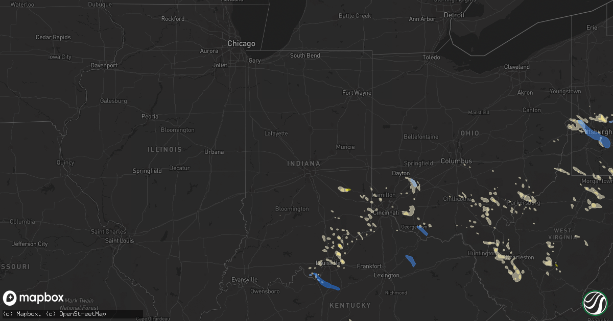
Hail Map in Indiana on June 22, 2022
Get this storm
June 22 map
$229
one time, instant access
Download today. No call, no setup
Keep the $229
Bought the map and want the full workflow? Apply the entire $229 to a subscription within 7 days. None of it is wasted.
Every map, not just this one
This buys you this map. Subscription and you get every map we run, in the markets you choose from a few cities to whole states to nationwide. Plus real-time alerts the moment a storm fires.
Contact data
Name, contact info, occupancy, even credit band for addresses in the footprint. You go from where it hit to who to call.
Become the source they trust
Unlimited branding weather history reports on demand. You already have the documented answer ready for the property owner, and you are the one who showed up with it.
Property data and RoofTrace estimates
Pull up any address you have got, its value and the exact code rules for that jurisdiction, straight from One Click Code. Then RoofTrace estimates the squares, pitch, and roof value, priced the way you price.
Storm reports in Indiana
Indiana
| Date | Description |
|---|---|
| 06/22/20223:57 PM CDT | Several large branches down. Time estimated by radar. |
| 06/22/20223:25 PM CDT | Tree down on house. |
| 06/22/20223:25 PM CDT | Tree down on top of car on 111s. |
| 06/22/20223:20 PM CDT | Tree down on west st. |
| 06/22/20223:13 PM CDT | A large tree limb fell on a fence on bartholomew boulevard. |
| 06/22/20223:10 PM CDT | Trees and large limbs down on sr 403. |
| 06/22/20223:10 PM CDT | Downed power line hanging over street. |
| 06/22/20223:03 PM CDT | Trees down at intersection of us 31 and biggs rd. |
| 06/22/20222:50 PM CDT | Tree down across voyles rd. |
| 06/22/20222:47 PM CDT | Trees down on daisy hill rd. |
| 06/22/20222:42 PM CDT | Report of a tree down in lexington. Time estimated from radar. |
| 06/22/20222:30 PM CDT | Several large branches down in the western part of franklin county. Time estimated from radar. |
| 06/22/20222:22 PM CDT | Uprooted tree of unknown size and health at this location. |
| 06/21/202211:50 PM CDT | At 449 PM EDT, a severe thunderstorm was located 10 miles southwest of Valley Station, moving east at 35 mph. HAZARD...60 mph wind gusts. SOURCE...Radar indicated. IMPACT...Expect damage to roofs, siding, and trees. Locations impacted include... Fort Knox, Shepherdsville, Lebanon Junction, Muldraugh, West Point, Bardstown Junction, Hobbs, Cedar Grove, Belmont, Pitts Point and Howard. |
| 06/21/202211:31 PM CDT | At 430 PM EDT, severe thunderstorms were from Glenview to Shively to 7 miles southwest of Valley Station, moving east at 25 mph. HAZARD...60 mph wind gusts and quarter size hail. SOURCE...Radar indicated. IMPACT...Hail damage to vehicles is expected. Expect wind damage to roofs, siding, and trees. Locations impacted include... Louisville, Jeffersonville, New Albany, Jeffersontown, St. Matthews, Shively, Lyndon, Middletown, Douglass Hills, and Prospect. |
| 06/21/202211:27 PM CDT | At 427 PM EDT, severe thunderstorms were located from near Delhi Township to near Rising Sun, moving southeast at 25 mph. HAZARD...60 mph wind gusts. SOURCE...Radar indicated. IMPACT...Expect damage to trees and power lines. Locations impacted include... Cincinnati, Covington, Florence, Independence, Erlanger, Edgewood, Elsmere, Fort Mitchell, Villa Hills, Taylor Mill, Fort Wright, Crescent Springs, Aurora, Walton, Crestview Hills, Lakeside Park, Rising Sun, Oakbrook, Burlington and Claryville.This includes the following Interstates... I-71 in Kentucky between mile markers 62 and 77. I-75 in Kentucky between mile markers 165 and 186. |
| 06/21/202211:19 PM CDT | At 418 PM EDT, severe thunderstorms were from near Bedford to 9 miles northwest of La Grange to near Prospect, moving east at 15 mph. HAZARD...60 mph wind gusts and quarter size hail. SOURCE...Radar indicated. IMPACT...Hail damage to vehicles is expected. Expect wind damage to roofs, siding, and trees. Locations impacted include... La Grange, Bedford, Pendleton, Crestwood, Orchard Grass Hills, Pewee Valley, Owen, Goshen, Campbellsburg and Bethlehem. |
| 06/21/202211:13 PM CDT | At 413 PM EDT, severe thunderstorms were from near New Albany to near Corydon to 9 miles southwest of Brandenburg, moving east at 25 mph. HAZARD...60 mph wind gusts and quarter size hail. SOURCE...Radar indicated. IMPACT...Hail damage to vehicles is expected. Expect wind damage to roofs, siding, and trees. Locations impacted include... Louisville, Jeffersonville, New Albany, Shively, Corydon, Brandenburg, Glenview, Mockingbird Valley, Pleasure Ridge Par and Pleasure Ridge Park. |
| 06/21/202210:15 PM CDT | At 315 PM EDT, a severe thunderstorm was located near Lake Santee, moving southeast at 10 mph. HAZARD...60 mph wind gusts and quarter size hail. SOURCE...Radar indicated. IMPACT...Minor hail damage to vehicles is possible. Expect wind damage to trees and power lines. Locations impacted include... Batesville, Oldenburg, Lake Santee, Blooming Grove, Metamora, Laurel, Peppertown, Andersonville, Hamburg and Buena Vista. |
| 06/21/202210:08 PM CDT | At 308 PM EDT, a severe thunderstorm was located 8 miles south of Rushville, or 18 miles northwest of Batesville, moving southeast at 25 mph. HAZARD...60 mph wind gusts and quarter size hail. SOURCE...Radar indicated. IMPACT...Hail damage to vehicles is expected. Expect wind damage to roofs, siding, and trees. This severe thunderstorm will be near... Clarksburg around 325 PM EDT.Other locations in the path of this severe thunderstorm include LakeSantee. |
All States Impacted by Hail Map on June 22, 2022
Cities Impacted by Hail Map on June 22, 2022
- Bedford, PA
- Xenia, OH
- Jamestown, OH
- New Lexington, OH
- Somerset, OH
- Blossburg, PA
- Wellsboro, PA
- Clifton Springs, NY
- Shortsville, NY
- Caldwell, OH
- Macksburg, OH
- Dexter City, OH
- Greensburg, PA
- Benezett, PA
- Huntingdon, PA
- State College, PA
- Boalsburg, PA
- Markleysburg, PA
- Palmyra, NY
- Bloomingdale, OH
- Coolville, OH
- Guysville, OH
- Frenchville, PA
- Cumberland, MD
- Oldtown, MD
- Chillicothe, OH
- Philippi, WV
- Lost Creek, WV
- Bridgeport, WV
- Mount Clare, WV
- Brave, PA
- Blacksville, WV
- Spraggs, PA
- Holbrook, PA
- New Freeport, PA
- Aleppo, PA
- Wind Ridge, PA
- West Point, KY
- Cedar Grove, IN
- New Trenton, IN
- West Harrison, IN
- Brookville, IN
- South Webster, OH
- Minford, OH
- Bush, LA
- Covington, LA
- Franklinton, LA
- Cincinnati, OH
- Harrison, OH
- Burkesville, KY
- Henryville, IN
- Memphis, IN
- Borden, IN
- Hopewell, PA
- Saxton, PA
- Woodbury, PA
- Keedysville, MD
- Fairplay, MD
- Sharpsburg, MD
- Shepherdstown, WV
- Falling Waters, WV
- Boonsboro, MD
- Martinsburg, WV
- Kearneysville, WV
- Hagerstown, MD
- Williamsport, MD
- Gerrardstown, WV
- Clear Brook, VA
- Winchester, VA
- Berkeley Springs, WV
- Gore, VA
- Cross Junction, VA
- Stephenson, VA
- Glengary, WV
- Stephens City, VA
- Hedgesville, WV
- Wellington, KS
- Caldwell, KS
- Ray, OH
- South Bloomingville, OH
- McArthur, OH
- Londonderry, OH
- Oregonia, OH
- Clarksville, OH
- Milroy, IN
- Greensburg, IN
- Rushville, IN
- Bloomfield, IN
- Saint Marys, PA
- Hebron, KY
- North Bend, OH
- Addyston, OH
- Cleves, OH
- Latrobe, PA
- Newkirk, OK
- Mineral Wells, WV
- Flemington, WV
- Moatsville, WV
- Luray, VA
- Strasburg, VA
- Rileyville, VA
- Bentonville, VA
- Front Royal, VA
- Fort Valley, VA
- New Washington, IN
- Nabb, IN
- Charlestown, IN
- Westport, KY
- Marysville, IN
- Harpers Ferry, WV
- Shenandoah Junction, WV
- Halstead, KS
- Valley Center, KS
- Sedgwick, KS
- Bentley, KS
- Colwich, KS
- Aurora, IN
- Rising Sun, IN
- Romney, WV
- Shanks, WV
- Bidwell, OH
- Vinton, OH
- Gallipolis, OH
- Ganado, AZ
- Milton, WV
- Glenwood, WV
- Ashton, WV
- Greensburg, KS
- Haviland, KS
- Hickman, KY
- Union City, TN
- Duck, WV
- Nelsonville, OH
- New Marshfield, OH
- Elkton, VA
- Shenandoah, VA
- Harrisonburg, VA
- Broadway, VA
- Fisherville, KY
- Simpsonville, KY
- Patriot, IN
- Martin, TN
- Chester, WV
- Aliquippa, PA
- Oakdale, PA
- New Cumberland, WV
- Burgettstown, PA
- Industry, PA
- Midland, PA
- Hookstown, PA
- Georgetown, PA
- Imperial, PA
- Coraopolis, PA
- McDonald, PA
- Clinton, PA
- New Manchester, WV
- Crescent, PA
- Monaca, PA
- East Liverpool, OH
- Shippingport, PA
- Byrdstown, TN
- Louisville, KY
- Belpre, OH
- Fleming, OH
- Marietta, OH
- Stafford, KS
- Butler, KY
- Foster, KY
- Albany, OH
- Athens, OH
- Mullinville, KS
- Oak Hill, OH
- West Union, OH
- Seaman, OH
- Winchester, OH
- Wilkesville, OH
- Langsville, OH
- Kingman, KS
- Offerle, KS
- Bucklin, KS
- Willcox, AZ
- Warsaw, KY
- Lexington, IN
- Needham, AL
- Goshen, KY
- Crestwood, KY
- Prospect, KY
- Coldwater, KS
- Purgitsville, WV
- Baker, WV
- Rio, WV
- Old Fields, WV
- Moorefield, WV
- Buffalo, WV
- Culloden, WV
- Hamlin, WV
- Hurricane, WV
- Medicine Lodge, KS
- Nashville, KS
- Garden Plain, KS
- Andale, KS
- Newton, KS
- Goddard, KS
- Mount Hope, KS
- Isabel, KS
- Wilmore, KS
- Morgantown, WV
- Maidsville, WV
- Waverly, WV
- Crown City, OH
- Lesage, WV
- Fairfield, OH
- Hamilton, OH
- Batavia, OH
- Williamsburg, OH
- Sylvia, KS
- St John, KS
- Costa, WV
- Ridgeview, WV
- Ashford, WV
- Alum Creek, WV
- Nellis, WV
- Ona, WV
- Summersville, WV
- Drennen, WV
- Haven, KS
- Ebensburg, PA
- Colver, PA
- Cranberry, PA
- Knox, PA
- Waterford, OH
- Stockport, OH
- Adah, PA
- New Salem, PA
- McClellandtown, PA
- Bath, IN
- Oxford, OH
- Glouster, OH
- Griffithsville, WV
- Sod, WV
- Centre Hall, PA
- Bellefonte, PA
- Spivey, KS
- Norwich, KS
- Tornado, WV
- Saint Albans, WV
- Ivydale, WV
- Foster, WV
- Danville, WV
- Madison, WV
- Loysburg, PA
- Mercersburg, PA
- Altoona, PA
- Dysart, PA
- Howard, PA
- Brockport, NY
- Hamlin, NY
- Hilton, NY
- New Bethlehem, PA
- Milesburg, PA
- Okeana, OH
- Weedville, PA
- Lilly, PA
- Cassandra, PA
- Fredericksburg, VA
- Farmington, PA
- Bruceton Mills, WV
- Fairchance, PA
- Gibbon Glade, PA
- Jane Lew, WV
- Salem, WV
- Minneola, KS
- Milton, KY
- Pool, WV
- Quinwood, WV
- Mount Nebo, WV
- Wasco, CA
- Birch Tree, MO
- Winona, MO
- Bloomery, WV
- Great Cacapon, WV
- Greenville, VA
- Milam, WV
- Moundsville, WV
- Glen Easton, WV
- Proctor, WV
- Williamsville, MO
- Plevna, KS
- Dudley, MO
- Elk Horn, KY
- Columbia, KY
- Hacker Valley, WV
- Edinburg, VA
- Lucasville, OH
- Fairmont, WV
- Thornton, WV
- Bedford, KY
- Winfield, WV
- Eleanor, WV
- Scott Depot, WV
- Red House, WV
- Belle Plaine, KS
- Arkansas City, KS
- Oxford, KS
- Geuda Springs, KS
- South Haven, KS
- Honeoye Falls, NY
- Mendon, NY
- Pittsford, NY
- Madison, VA
- Rochelle, VA
- Vienna, WV
- Williamstown, WV
- Parkersburg, WV
- Clay, WV
- Victor, WV
- Swiss, WV
- Seth, WV
- Peytona, WV
- Dayton, PA
- White, PA
- Scottdale, PA
- Acme, PA
- Indiana, PA
- Coudersport, PA
- Markleton, PA
- Confluence, PA
- Lowell, OH
- Beverly, OH
- Jackson, OH
- Wallace, WV
- Clarksburg, WV
- Frankfort, OH
- Lovettsville, VA
- Purcellville, VA
- Charles Town, WV
- Round Hill, VA
- Moores Hill, IN
- Dillsboro, IN
- Elizabeth, IN
- Laconia, IN
- North Vernon, IN
- Scipio, IN
- Westport, IN
- Stafford, VA
- Fulks Run, VA
- Bergton, VA
- Corydon, IN
- Apple Grove, WV
- Fraziers Bottom, WV
- Orgas, WV
- Comfort, WV
- Spout Spring, VA
- Red House, VA
- Appomattox, VA
- Concord, VA
- Addison, PA
- West Hamlin, WV
- Scottown, OH
- Cubero, NM
- Bloomfield, NY
- Victor, NY
- Pittsburgh, PA
- Fallentimber, PA
- Walker, WV
- Newport, OH
- Saint Marys, WV
- Tarentum, PA
- Saxonburg, PA
- Gibsonia, PA
- Russellton, PA
- Valencia, PA
- Cheswick, PA
- Bairdford, PA
- Belleville, WV
- Ravenswood, WV
- Butlerville, IN
- Glassport, PA
- Mckeesport, PA
- Elrama, PA
- Dravosburg, PA
- Clairton, PA
- Webster, PA
- Monongahela, PA
- Finleyville, PA
- West Mifflin, PA
- West Elizabeth, PA
- Belle Vernon, PA
- Elizabeth, PA
- Deputy, IN
- Long Bottom, OH
- Reedsville, OH
- Breeding, KY
- North Newton, KS
- Walton, KS
- Hardtner, KS
- Monterville, WV
- Pickens, WV
- Sardinia, OH
- Madison, IN
- Masonic Home, KY
- New Albany, IN
- Jeffersonville, IN
- Clarksville, IN
- South Charleston, WV
- Georgetown, IN
- Lanesville, IN
- Pratt, KS
- Conway Springs, KS
- Grandin, MO
- Vincent, OH
- Reno, OH
- Ambridge, PA
- Baden, PA
- Beaver, PA
- Freedom, PA
- Sewickley, PA
- Shubuta, MS
- Vossburg, MS
- Vail, AZ
- Elgin, AZ
- Julian, WV
- Alkol, WV
- Yawkey, WV
- Russellville, OH
- Georgetown, OH
- Sanders, KY
- Vevay, IN
- Worthville, KY
- Ghent, KY
- Inman, KS
- Twilight, WV
- Jeffrey, WV
- Racine, WV
- Bob White, WV
- Gordon, WV
- Bim, WV
- Van, WV
- Dexter, KS
- Maple City, KS
- Scottsburg, IN
- Underwood, IN
- Grafton, WV
- Independence, WV
- Homer City, PA
- Penn Run, PA
- Wilmington, OH
- Ford City, PA
- Bulger, PA
- Petersburg, KY
- Hanover, IN
- Kendall, NY
- Holley, NY
- Home, PA
- Clymer, PA
- Marion Center, PA
- Martinsburg, PA
- Lansing, WV
- Lookout, WV
- Edmond, WV
- Waterloo, OH
- Smithfield, PA
- Uniontown, PA
- Masontown, PA
- La Grange, KY
- Newburg, WV
- Farmington, WV
- Barrackville, WV
- Tunnelton, WV
- Pomeroy, OH
- Winfield, KS
- Waterport, NY
- Aroda, VA
- Pratts, VA
- New Middletown, IN
- Murdock, KS
- Bogalusa, LA
- Milan, KS
- Argonia, KS
- Springville, TN
- Buchanan, TN
- Big Sandy, TN
- Pewee Valley, KY
- Maize, KS
- Vandergrift, PA
- Leechburg, PA
- Fort Hill, PA
- Everett, PA
- Creighton, PA
- Bakerstown, PA
- Commodore, PA
- Lost City, WV
- Wardensville, WV
- Hamden, OH
- Kingston, OH
- Woodford, VA
- Glens Fork, KY
- Mayfield, KS
- Trenton, OH
- Gloster, MS
- Anacoco, LA
- Willow Wood, OH
- Hutchinson, KS
- Partridge, KS
- Pickerington, OH
- Carroll, OH
- Adena, OH
- Cadiz, OH
- Rockport, WV
- West College Corner, IN
- Harmony, PA
- Paris Crossing, IN
- Wallback, WV
- Nebo, WV
- Nitro, WV
- Charleston, WV
- Palestine, WV
- Creston, WV
- Leon, WV
- Cranberry Township, PA
- Allison Park, PA
- Mars, PA
- Bradfordwoods, PA
- Wexford, PA
- Natrona Heights, PA
- Sarver, PA
- Warrendale, PA
- Guilford, IN
- Lawrenceburg, IN
- Bellbrook, OH
- Spring Valley, OH
- Port William, OH
- Dayton, OH
- Waynesville, OH
- Owensville, OH
- Fayetteville, OH
- Mount Orab, OH
- Blanchester, OH
- Quicksburg, VA
- Mount Jackson, VA
- Basye, VA
- Turon, KS
- Iuka, KS
- Castlewood, VA
- Lebanon, VA
- Evans City, PA
- Newark, NY
- New Enterprise, PA
- Rochester, NY
- Campbellsburg, KY
- Kittanning, PA
- Worthington, PA
- Midland, OH
- Bradford, PA
- Salamanca, NY
- Woodstock, VA
- Marienville, PA
- Tionesta, PA
- Karthaus, PA
- Canal Winchester, OH
- Leesville, LA
- Elizabeth, WV
- Petroleum, WV
- Mayport, PA
- Punxsutawney, PA
- Timblin, PA
- Kent, NY
- Lebanon, OH
- Poplar Bluff, MO
- Creekside, PA
- Shelocta, PA
- Rural Valley, PA
- Millfield, OH
- Chauncey, OH
- Belva, WV
- Madera, CA
- Cameron, WV
- Clarington, OH
- Powhatan Point, OH
- Parkhill, PA
- Johnstown, PA
- Washington, WV
- Creola, OH
- Zaleski, OH
- New Plymouth, OH
- Stanley, VA
- Carrollton, KY
- Sparta, KY
- Mesquite, NM
- Osage, WV
- Mount Morris, PA
- Dilliner, PA
- Stewart, OH
- Pottersdale, PA
- Freeport, PA
- Whipple, OH
- Lower Salem, OH
- Mannington, WV
- Northern Cambria, PA
- Shade, OH
- Russell Springs, KY
- Puxico, MO
- Wappapello, MO
- Abbyville, KS
- Syria, VA
- Union, KY
- Walton, KY
- Verona, KY
- Vidalia, LA
- Otisco, IN
- Sellersburg, IN
- Peck, KS
- Manchester, OH
- Vanceburg, KY
- Ripley, OH
- Buena Vista, PA
- Yukon, PA
- Herminie, PA
- Smithton, PA
- Bridgeville, PA
- Carnegie, PA
- Homestead, PA
- Greenock, PA
- Presto, PA
- Bethel Park, PA
- South Park, PA
- Lowber, PA
- West Newton, PA
- Duquesne, PA
- Rillton, PA
- McKees Rocks, PA
- Irwin, PA
- Wyano, PA
- Sutersville, PA
- New Kensington, PA
- Ligonier, PA
- Ranson, WV
- Inwood, WV
- Mauckport, IN
- Fort Knox, KY
- Bardstown, KY
- Boston, KY
- Lebanon Junction, KY
- Shepherdsville, KY
- Olympia, KY
- Carlisle, KY
- Sharpsburg, KY
- Moorefield, KY
- Owingsville, KY
- Laurel, IN
- Fort Lee, VA
- Henrico, VA
- Petersburg, VA
- Bowling Green, VA
- Sandston, VA
- Ashland, VA
- Richmond, VA
- Milford, VA
- Mechanicsville, VA
- Ruther Glen, VA
- Prince George, VA
- King George, VA
- Disputanta, VA
- Chesterfield, VA
- Hanover, VA
- Port Royal, VA
- Hopewell, VA
- Colonial Heights, VA
- Chester, VA
- Glen Allen, VA
- Doswell, VA
- Mitchells, VA
- Culpeper, VA
- Elkwood, VA
- Marshall, VA
- Stevensburg, VA
- Reva, VA
- Delaplane, VA
- Brandy Station, VA
- Brightwood, VA
- Hume, VA
- Midland, VA
- Warrenton, VA
- Remington, VA
- Castleton, VA
- The Plains, VA
- Amissville, VA
- Rapidan, VA
- Rixeyville, VA
- Jeffersonton, VA
- Upperville, VA
- Broad Run, VA
- Locust Dale, VA
- Bealeton, VA


