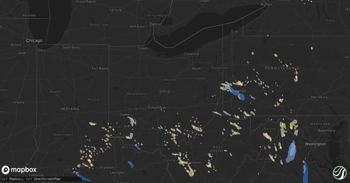
Hail Map in Ohio on June 22, 2022
Get this storm
June 22 map
$229
one time, instant access
Download today. No call, no setup
Keep the $229
Bought the map and want the full workflow? Apply the entire $229 to a subscription within 7 days. None of it is wasted.
Every map, not just this one
This buys you this map. Subscription and you get every map we run, in the markets you choose from a few cities to whole states to nationwide. Plus real-time alerts the moment a storm fires.
Contact data
Name, contact info, occupancy, even credit band for addresses in the footprint. You go from where it hit to who to call.
Become the source they trust
Unlimited branding weather history reports on demand. You already have the documented answer ready for the property owner, and you are the one who showed up with it.
Property data and RoofTrace estimates
Pull up any address you have got, its value and the exact code rules for that jurisdiction, straight from One Click Code. Then RoofTrace estimates the squares, pitch, and roof value, priced the way you price.
Storm reports in Ohio
Ohio
| Date | Description |
|---|---|
| 06/22/20226:35 PM CDT | Tree down. |
| 06/22/20225:45 PM CDT | Tree down. |
| 06/22/20225:42 PM CDT | A few trees down along careys run road. Time estimated by radar. |
| 06/22/20225:37 PM CDT | Tree down. |
| 06/22/20225:35 PM CDT | Tree down. |
| 06/22/20225:33 PM CDT | 5 trees down in the area. |
| 06/22/20225:30 PM CDT | Corrects previous tornado report from 3 ne albany. Person who submitted the report confirmed that all trees were laying in the same direction. Reports of severe damage |
| 06/22/20225:27 PM CDT | 5 trees down in the area. |
| 06/22/20225:27 PM CDT | Tree down. |
| 06/22/20225:27 PM CDT | Tree down. |
| 06/22/20225:27 PM CDT | Tree down. |
| 06/22/20225:20 PM CDT | Tree down. |
| 06/22/20225:20 PM CDT | A few trees were downed along blue run township road. Time estimated by radar. |
| 06/22/20225:16 PM CDT | A few trees down along thomas hollow road. Time estimated rom radar. |
| 06/22/20225:06 PM CDT | Tree down. |
| 06/22/20224:50 PM CDT | A couple of trees down on wires in the georgetown area.time estimated by radar. |
| 06/22/20224:48 PM CDT | A tree was downed along russellville-winchester road. Time estimated from radar. |
| 06/22/20224:10 PM CDT | A few trees down across northern fairfield county. Time estimated by radar. |
| 06/22/20224:06 PM CDT | Tree reported down on secondary road. |
| 06/22/20224:05 PM CDT | Tree down at intersection. |
| 06/22/20223:50 PM CDT | Large tree limbs down |
| 06/22/20223:27 PM CDT | Erroneous report from a previous day regarding damage in reading |
| 06/22/20223:27 PM CDT | A few trees were downed in whitewater township. Time estimated by radar. |
| 06/22/20223:27 PM CDT | Several large trees down at saints peter and paul cemetery in reading. Via social media |
| 06/22/20223:22 PM CDT | Report of trees down in the area. Time estiamted based on radar. |
| 06/22/20223:13 PM CDT | Two large healthy tree branches reported down. Branches fell on wooden fence causing damage. Time estimated from radar. |
| 06/22/20223:13 PM CDT | Large branhes down on wires. Time estimated by radar. |
| 06/22/20223:05 PM CDT | Report of multiple trees down. Time estimated based on radar. |
| 06/22/20223:03 PM CDT | Several trees down in ross township along hamilton cleves road. Time estimated by radar. |
| 06/22/20223:00 PM CDT | A tree was doen on jack road near the intersection of phillips road. Time estimated from radar. |
| 06/22/20223:00 PM CDT | A large tree fell through the top of a park building. Time estimated by radar. |
| 06/22/20222:35 PM CDT | Trees down near the intersection of us35 and sr380. Time estimated from radar. |
| 06/22/20222:35 PM CDT | Numerous trees down across southern green county. Time estimated from radar to be from 335 pm until about 345 pm. |
| 06/22/20222:27 PM CDT | Some large branches and a small tree were downed near the intesection of hewitt avenue and whipp road. Time estimated by radar. |
| 06/22/20222:45 AM CDT | At 745 PM EDT, a severe thunderstorm was located 11 miles north of Ona, or 11 miles northeast of Proctorville, moving east at 30 mph. HAZARD...60 mph wind gusts and quarter size hail. SOURCE...Radar indicated. IMPACT...Hail damage to vehicles is expected. Expect wind damage to roofs, siding, and trees. Locations impacted include... Winfield, Hurricane, Milton, Eleanor, Buffalo, Teays Valley, Culloden, Crown City, Athalia, Scottown, Ashton, Green Bottom and Fraziers Bottom.This includes Interstate 64 in West Virginia between mile markers 27and 29, and between mile markers 31 and 39. |
| 06/22/20221:52 AM CDT | At 652 PM EDT, severe thunderstorms were located along a line extending from near Clarktown to Stoops, moving south at 45 mph. HAZARD...60 mph wind gusts. SOURCE...Radar indicated. IMPACT...Expect damage to roofs, siding, and trees. Locations impacted include... Ashland, Ironton, Grayson, Gallipolis, Coal Grove, Olive Hill, Oak Hill, Rio Grande, Cannonsburg, Lake Vesuvius, Grayson Lake State Park, Carter Caves State Park, Greenup, Coalton, Denton, Gesling, Greenbo Lake, Oldtown, Load and Letitia.This includes Interstate 64 in Kentucky between mile markers 149 and184. |
| 06/22/20221:45 AM CDT | At 644 PM EDT, a severe thunderstorm was located 10 miles north of Marietta, moving southeast at 25 mph. HAZARD...60 mph wind gusts and quarter size hail. SOURCE...Radar indicated. IMPACT...Hail damage to vehicles is expected. Expect wind damage to roofs, siding, and trees. Locations impacted include... Marietta, Macksburg, Lower Salem and Devola. This includes Interstate 77 in Ohio between mile markers 3 and 17. |
| 06/22/20221:42 AM CDT | At 642 PM EDT, a severe thunderstorm was located near Athens, moving southeast at 25 mph. HAZARD...60 mph wind gusts and quarter size hail. SOURCE...Radar indicated. IMPACT...Hail damage to vehicles is expected. Expect wind damage to roofs, siding, and trees. Locations impacted include... Athens. |
| 06/22/20221:35 AM CDT | At 634 PM EDT, severe thunderstorms were located from 6 miles southwest of Rosemount to near Vanceburg to near Foxport, moving east at 20 mph. HAZARD...60 mph wind gusts. SOURCE...Radar indicated. IMPACT...Expect damage to trees and power lines. Locations impacted include... Portsmouth, Wheelersburg, New Boston, Vanceburg, Head of Grassy, Rosemount, Camp Dix, Franklin Furnace, Sciotodale, Saint Paul, Kinniconick, Friendship, Petersville, Stricklett, Rexton, Sandy Springs, Buena Vista in Scioto County, Firebrick, West Portsmouth and Harris. |
| 06/22/20221:23 AM CDT | At 623 PM EDT, severe thunderstorms were located along a line extending from near Lake Hope State Park to 9 miles east of Waverly, moving southeast at 35 mph. HAZARD...60 mph wind gusts and quarter size hail. SOURCE...Radar indicated. IMPACT...Hail damage to vehicles is expected. Expect wind damage to roofs, siding, and trees. Locations impacted include... Jackson, Wellston, Mcarthur, Albany, Lake Hope State Park, Hamden, Coalton, Zaleski, Creola, Radcliffe, Allensville, Byer and Carpenter. |
| 06/22/20221:23 AM CDT | At 623 PM EDT, a cluster of severe thunderstorms was centered near Powhatan Point, or 9 miles south of Moundsville, moving southeast at 30 mph. HAZARD...60 mph wind gusts. SOURCE...Radar indicated. IMPACT...Expect damage to trees and power lines, resulting in some power outages. Locations impacted include... Moundsville, New Martinsville, Shadyside, Powhatan Point, Glen Dale, Pine Grove, Hundred, Jacksonburg, Clarington, Smithfield, Cameron, and New Freeport. |
| 06/22/20221:12 AM CDT | At 612 PM EDT, a severe thunderstorm was located over Glouster, moving southeast at 15 mph. HAZARD...60 mph wind gusts and quarter size hail. SOURCE...Radar indicated. IMPACT...Hail damage to vehicles is expected. Expect wind damage to roofs, siding, and trees. Locations impacted include... Glouster, Chesterhill, Jacksonville, Trimble, Amesville and Burr Oak State Park. |
| 06/22/20221:09 AM CDT | At 609 PM EDT, a severe thunderstorm was located over Nelsonville, moving southeast at 15 mph. HAZARD...60 mph wind gusts and quarter size hail. SOURCE...Radar indicated. IMPACT...Hail damage to vehicles is expected. Expect wind damage to roofs, siding, and trees. Locations impacted include... Athens, Nelsonville, Chauncey, Buchtel, Amesville and The Plains. |
| 06/22/20221:09 AM CDT | At 609 PM EDT, a severe thunderstorm was located near Caldwell, moving southeast at 30 mph. HAZARD...60 mph wind gusts. SOURCE...Radar indicated. IMPACT...Expect damage to trees and power lines, resulting in some power outages. Locations impacted include... Caldwell, Dudley, Pleasant City, Summerfield, Belle Valley, Sarahsville, Dexter City, Antioch, Stafford, Graysville, Harriettsville, and Wolf Run State Park. |
| 06/22/20221:08 AM CDT | At 608 PM EDT, a severe thunderstorm was located 9 miles northwest of Mcarthur, moving southeast at 15 mph. HAZARD...60 mph wind gusts and penny size hail. SOURCE...Radar indicated. IMPACT...Expect damage to roofs, siding, and trees. Locations impacted include... Mcarthur, Zaleski, Byer, Creola, Allensville and Eagle Mills. |
| 06/22/202212:56 AM CDT | At 556 PM EDT, a severe thunderstorm was located over Perry State Forest, moving southeast at 20 mph. HAZARD...60 mph wind gusts and penny size hail. SOURCE...Radar indicated. IMPACT...Expect damage to roofs, siding, and trees. Locations impacted include... Perry State Forest and Crooksville. |
| 06/22/202212:47 AM CDT | At 547 PM EDT, a severe thunderstorm was located 10 miles east of Chillicothe, moving southeast at 35 mph. HAZARD...60 mph wind gusts and quarter size hail. SOURCE...Radar indicated. IMPACT...Minor hail damage to vehicles is possible. Expect wind damage to trees and power lines. Locations impacted include... Londonderry and Mooresville. |
| 06/22/202212:27 AM CDT | At 527 PM EDT, severe thunderstorms were located from near Neville to Falmouth to near Williamstown, moving south at 20 mph. HAZARD...60 mph wind gusts. SOURCE...Radar indicated. IMPACT...Expect damage to trees and power lines. Locations impacted include... Falmouth, Brooksville, Butler, Neville, Morgan, Moscow, Mount Auburn, Browning Corner, Willow Grove, Bradford, Stonewall, Powersville, Peach Grove, Ivor, Johnsville, Hittville, Goforth, Woolcutt, Neave and Milford. |
| 06/22/202212:24 AM CDT | At 524 PM EDT, a severe thunderstorm was located over Forked Run State Park, moving southeast at 20 mph. HAZARD...60 mph wind gusts and quarter size hail. SOURCE...Radar indicated. IMPACT...Hail damage to vehicles is expected. Expect wind damage to roofs, siding, and trees. Locations impacted include... Forked Run State Park, Ravenswood, Belleville, Reedsville and Portland.This includes Interstate 77 in West Virginia between mile markers 146and 160. |
| 06/22/202212:21 AM CDT | At 521 PM EDT, a severe thunderstorm was located near Mount Orab, moving south at 10 mph. HAZARD...60 mph wind gusts. SOURCE...Radar indicated. IMPACT...Expect damage to trees and power lines. Locations impacted include... Mount Orab, Sardinia, Fayetteville, St. Martin, State Route 32 at US Route 68, Chasetown, Greenbush, Locust Ridge, Buford, Lake Lorelei and New Hope. |
| 06/22/202212:14 AM CDT | At 513 PM EDT, a severe thunderstorm was located over New Cumberland, or near Wellsville, moving southeast at 25 mph. HAZARD...60 mph wind gusts. SOURCE...Radar indicated. IMPACT...Expect damage to trees and power lines, resulting in some power outages. Locations impacted include... Weirton, Toronto, Chester, Imperial, New Cumberland, Burgettstown, New Manchester, Empire, Stratton, Frankfort Springs, Atlasburg, and Slovan. |
| 06/21/202211:53 PM CDT | At 453 PM EDT, a severe thunderstorm was located near Beverly, moving southeast at 10 mph. HAZARD...60 mph wind gusts and quarter size hail. SOURCE...Radar indicated. IMPACT...Hail damage to vehicles is expected. Expect wind damage to roofs, siding, and trees. Locations impacted include... Beverly and Lowell. |
| 06/21/202211:46 PM CDT | At 446 PM EDT, a severe thunderstorm was located over Pickerington, moving southeast at 20 mph. HAZARD...60 mph wind gusts and quarter size hail. SOURCE...Radar indicated. IMPACT...Minor hail damage to vehicles is possible. Expect wind damage to trees and power lines. Locations impacted include... Columbus, Lancaster, Pickerington, Canal Winchester, Groveport, Baltimore, Pleasantville, Obetz, Royalton, Lithopolis, Amanda, Thurston, Carroll, Fairfield County Airport, US Route 22 at State Route 159, Slate Run Metro Park, Clearport, Dumontville and Blacklick Estates. |
| 06/21/202211:29 PM CDT | At 429 PM EDT, a severe thunderstorm was located 7 miles southwest of Albany, moving southeast at 10 mph. HAZARD...60 mph wind gusts and quarter size hail. SOURCE...Radar indicated. IMPACT...Hail damage to vehicles is expected. Expect wind damage to roofs, siding, and trees. Locations impacted include... Dyesville, Dexter and Carpenter. |
| 06/21/202211:11 PM CDT | At 411 PM EDT, a severe thunderstorm was located 9 miles south of New Concord, or 12 miles southwest of Cambridge, moving southeast at 10 mph. HAZARD...60 mph wind gusts. SOURCE...Radar indicated. IMPACT...Expect damage to trees and power lines, resulting in some power outages. Locations impacted include... Caldwell, Dudley, Cumberland, Belle Valley, Sarahsville, High Hill, and Wolf Run State Park. |
| 06/21/202211:03 PM CDT | At 402 PM EDT, a severe thunderstorm was located over Wilmington, moving southeast at 20 mph. HAZARD...60 mph wind gusts and quarter size hail. SOURCE...Radar indicated. IMPACT...Minor hail damage to vehicles is possible. Expect wind damage to trees and power lines. Locations impacted include... Wilmington, Sabina, Lynchburg, Leesburg, New Vienna, Martinsville, Highland, Melvin, Bloomington, New Antioch, Cuba, Lees Creek, Reesville, Morrisville, Ogden, Burtonville and Cowan Lake State Park.This includes I-71 in Ohio between mile markers 54 and 56. |
| 06/21/202210:47 PM CDT | At 347 PM EDT, a severe thunderstorm was located 9 miles northwest of Wellston, moving southeast at 10 mph. HAZARD...60 mph wind gusts and nickel size hail. SOURCE...Radar indicated. IMPACT...Expect damage to roofs, siding, and trees. Locations impacted include... Wellston, Hamden, Coalton and Byer. |
| 06/21/202210:46 PM CDT | At 346 PM EDT, a severe thunderstorm was located 9 miles northwest of Wellston, moving southeast at 10 mph. HAZARD...60 mph wind gusts and nickel size hail. SOURCE...Radar indicated. IMPACT...Expect damage to roofs, siding, and trees. Locations impacted include... Wellston, Hamden, Coalton and Byer. |
| 06/21/202210:40 PM CDT | At 340 PM EDT, a severe thunderstorm was located over Perry State Forest, moving southeast at 10 mph. HAZARD...60 mph wind gusts and penny size hail. SOURCE...Radar indicated. IMPACT...Expect damage to roofs, siding, and trees. Locations impacted include... New Lexington, Perry State Forest and Crooksville. |
| 06/21/202210:40 PM CDT | At 340 PM EDT, a severe thunderstorm was located near Cadiz, moving southeast at 15 mph. HAZARD...60 mph wind gusts. SOURCE...Radar indicated. IMPACT...Expect damage to trees and power lines, resulting in some power outages. Locations impacted include... Cadiz, Hopedale, Smithfield, Adena, Jewett, Dillonvale, Mount Pleasant, Harrisville, and Newell. |
| 06/21/202210:39 PM CDT | At 339 PM EDT, a severe thunderstorm was located over Trenton, moving southeast at 10 mph. HAZARD...60 mph wind gusts and quarter size hail. SOURCE...Radar indicated. IMPACT...Minor hail damage to vehicles is possible. Expect wind damage to trees and power lines. Locations impacted include... Middletown, Mason, Monroe, Trenton, Franklin, South Middletown, Seven Mile, Hunter, Williamsdale, Four Bridges, Wetherington, Jacksonburg, Hughes and Maustown.This includes I-75 in Ohio between mile markers 23 and 36. |
| 06/21/202210:38 PM CDT | At 337 PM EDT, a severe thunderstorm was located near Xenia, moving southeast at 25 mph. HAZARD...60 mph wind gusts and quarter size hail. SOURCE...Radar indicated. IMPACT...Minor hail damage to vehicles is possible. Expect wind damage to trees and power lines. Locations impacted include... Xenia, Wilmington, Bellbrook, Wilberforce, New Jasper, Harveysburg, Spring Valley, Bowersville, Port William, Centerville, Paintersville, Bloomington, Lumberton, Middleton Corner, Mount Holly, Roxanna, Oakland, Oldtown, Ogden and Kingman.This includes I-71 in Ohio between mile markers 43 and 59. |
All States Impacted by Hail Map on June 22, 2022
Cities Impacted by Hail Map on June 22, 2022
- Bedford, PA
- Xenia, OH
- Jamestown, OH
- New Lexington, OH
- Somerset, OH
- Blossburg, PA
- Wellsboro, PA
- Clifton Springs, NY
- Shortsville, NY
- Caldwell, OH
- Macksburg, OH
- Dexter City, OH
- Greensburg, PA
- Benezett, PA
- Huntingdon, PA
- State College, PA
- Boalsburg, PA
- Markleysburg, PA
- Palmyra, NY
- Bloomingdale, OH
- Coolville, OH
- Guysville, OH
- Frenchville, PA
- Cumberland, MD
- Oldtown, MD
- Chillicothe, OH
- Philippi, WV
- Lost Creek, WV
- Bridgeport, WV
- Mount Clare, WV
- Brave, PA
- Blacksville, WV
- Spraggs, PA
- Holbrook, PA
- New Freeport, PA
- Aleppo, PA
- Wind Ridge, PA
- West Point, KY
- Cedar Grove, IN
- New Trenton, IN
- West Harrison, IN
- Brookville, IN
- South Webster, OH
- Minford, OH
- Bush, LA
- Covington, LA
- Franklinton, LA
- Cincinnati, OH
- Harrison, OH
- Burkesville, KY
- Henryville, IN
- Memphis, IN
- Borden, IN
- Hopewell, PA
- Saxton, PA
- Woodbury, PA
- Keedysville, MD
- Fairplay, MD
- Sharpsburg, MD
- Shepherdstown, WV
- Falling Waters, WV
- Boonsboro, MD
- Martinsburg, WV
- Kearneysville, WV
- Hagerstown, MD
- Williamsport, MD
- Gerrardstown, WV
- Clear Brook, VA
- Winchester, VA
- Berkeley Springs, WV
- Gore, VA
- Cross Junction, VA
- Stephenson, VA
- Glengary, WV
- Stephens City, VA
- Hedgesville, WV
- Wellington, KS
- Caldwell, KS
- Ray, OH
- South Bloomingville, OH
- McArthur, OH
- Londonderry, OH
- Oregonia, OH
- Clarksville, OH
- Milroy, IN
- Greensburg, IN
- Rushville, IN
- Bloomfield, IN
- Saint Marys, PA
- Hebron, KY
- North Bend, OH
- Addyston, OH
- Cleves, OH
- Latrobe, PA
- Newkirk, OK
- Mineral Wells, WV
- Flemington, WV
- Moatsville, WV
- Luray, VA
- Strasburg, VA
- Rileyville, VA
- Bentonville, VA
- Front Royal, VA
- Fort Valley, VA
- New Washington, IN
- Nabb, IN
- Charlestown, IN
- Westport, KY
- Marysville, IN
- Harpers Ferry, WV
- Shenandoah Junction, WV
- Halstead, KS
- Valley Center, KS
- Sedgwick, KS
- Bentley, KS
- Colwich, KS
- Aurora, IN
- Rising Sun, IN
- Romney, WV
- Shanks, WV
- Bidwell, OH
- Vinton, OH
- Gallipolis, OH
- Ganado, AZ
- Milton, WV
- Glenwood, WV
- Ashton, WV
- Greensburg, KS
- Haviland, KS
- Hickman, KY
- Union City, TN
- Duck, WV
- Nelsonville, OH
- New Marshfield, OH
- Elkton, VA
- Shenandoah, VA
- Harrisonburg, VA
- Broadway, VA
- Fisherville, KY
- Simpsonville, KY
- Patriot, IN
- Martin, TN
- Chester, WV
- Aliquippa, PA
- Oakdale, PA
- New Cumberland, WV
- Burgettstown, PA
- Industry, PA
- Midland, PA
- Hookstown, PA
- Georgetown, PA
- Imperial, PA
- Coraopolis, PA
- McDonald, PA
- Clinton, PA
- New Manchester, WV
- Crescent, PA
- Monaca, PA
- East Liverpool, OH
- Shippingport, PA
- Byrdstown, TN
- Louisville, KY
- Belpre, OH
- Fleming, OH
- Marietta, OH
- Stafford, KS
- Butler, KY
- Foster, KY
- Albany, OH
- Athens, OH
- Mullinville, KS
- Oak Hill, OH
- West Union, OH
- Seaman, OH
- Winchester, OH
- Wilkesville, OH
- Langsville, OH
- Kingman, KS
- Offerle, KS
- Bucklin, KS
- Willcox, AZ
- Warsaw, KY
- Lexington, IN
- Needham, AL
- Goshen, KY
- Crestwood, KY
- Prospect, KY
- Coldwater, KS
- Purgitsville, WV
- Baker, WV
- Rio, WV
- Old Fields, WV
- Moorefield, WV
- Buffalo, WV
- Culloden, WV
- Hamlin, WV
- Hurricane, WV
- Medicine Lodge, KS
- Nashville, KS
- Garden Plain, KS
- Andale, KS
- Newton, KS
- Goddard, KS
- Mount Hope, KS
- Isabel, KS
- Wilmore, KS
- Morgantown, WV
- Maidsville, WV
- Waverly, WV
- Crown City, OH
- Lesage, WV
- Fairfield, OH
- Hamilton, OH
- Batavia, OH
- Williamsburg, OH
- Sylvia, KS
- St John, KS
- Costa, WV
- Ridgeview, WV
- Ashford, WV
- Alum Creek, WV
- Nellis, WV
- Ona, WV
- Summersville, WV
- Drennen, WV
- Haven, KS
- Ebensburg, PA
- Colver, PA
- Cranberry, PA
- Knox, PA
- Waterford, OH
- Stockport, OH
- Adah, PA
- New Salem, PA
- McClellandtown, PA
- Bath, IN
- Oxford, OH
- Glouster, OH
- Griffithsville, WV
- Sod, WV
- Centre Hall, PA
- Bellefonte, PA
- Spivey, KS
- Norwich, KS
- Tornado, WV
- Saint Albans, WV
- Ivydale, WV
- Foster, WV
- Danville, WV
- Madison, WV
- Loysburg, PA
- Mercersburg, PA
- Altoona, PA
- Dysart, PA
- Howard, PA
- Brockport, NY
- Hamlin, NY
- Hilton, NY
- New Bethlehem, PA
- Milesburg, PA
- Okeana, OH
- Weedville, PA
- Lilly, PA
- Cassandra, PA
- Fredericksburg, VA
- Farmington, PA
- Bruceton Mills, WV
- Fairchance, PA
- Gibbon Glade, PA
- Jane Lew, WV
- Salem, WV
- Minneola, KS
- Milton, KY
- Pool, WV
- Quinwood, WV
- Mount Nebo, WV
- Wasco, CA
- Birch Tree, MO
- Winona, MO
- Bloomery, WV
- Great Cacapon, WV
- Greenville, VA
- Milam, WV
- Moundsville, WV
- Glen Easton, WV
- Proctor, WV
- Williamsville, MO
- Plevna, KS
- Dudley, MO
- Elk Horn, KY
- Columbia, KY
- Hacker Valley, WV
- Edinburg, VA
- Lucasville, OH
- Fairmont, WV
- Thornton, WV
- Bedford, KY
- Winfield, WV
- Eleanor, WV
- Scott Depot, WV
- Red House, WV
- Belle Plaine, KS
- Arkansas City, KS
- Oxford, KS
- Geuda Springs, KS
- South Haven, KS
- Honeoye Falls, NY
- Mendon, NY
- Pittsford, NY
- Madison, VA
- Rochelle, VA
- Vienna, WV
- Williamstown, WV
- Parkersburg, WV
- Clay, WV
- Victor, WV
- Swiss, WV
- Seth, WV
- Peytona, WV
- Dayton, PA
- White, PA
- Scottdale, PA
- Acme, PA
- Indiana, PA
- Coudersport, PA
- Markleton, PA
- Confluence, PA
- Lowell, OH
- Beverly, OH
- Jackson, OH
- Wallace, WV
- Clarksburg, WV
- Frankfort, OH
- Lovettsville, VA
- Purcellville, VA
- Charles Town, WV
- Round Hill, VA
- Moores Hill, IN
- Dillsboro, IN
- Elizabeth, IN
- Laconia, IN
- North Vernon, IN
- Scipio, IN
- Westport, IN
- Stafford, VA
- Fulks Run, VA
- Bergton, VA
- Corydon, IN
- Apple Grove, WV
- Fraziers Bottom, WV
- Orgas, WV
- Comfort, WV
- Spout Spring, VA
- Red House, VA
- Appomattox, VA
- Concord, VA
- Addison, PA
- West Hamlin, WV
- Scottown, OH
- Cubero, NM
- Bloomfield, NY
- Victor, NY
- Pittsburgh, PA
- Fallentimber, PA
- Walker, WV
- Newport, OH
- Saint Marys, WV
- Tarentum, PA
- Saxonburg, PA
- Gibsonia, PA
- Russellton, PA
- Valencia, PA
- Cheswick, PA
- Bairdford, PA
- Belleville, WV
- Ravenswood, WV
- Butlerville, IN
- Glassport, PA
- Mckeesport, PA
- Elrama, PA
- Dravosburg, PA
- Clairton, PA
- Webster, PA
- Monongahela, PA
- Finleyville, PA
- West Mifflin, PA
- West Elizabeth, PA
- Belle Vernon, PA
- Elizabeth, PA
- Deputy, IN
- Long Bottom, OH
- Reedsville, OH
- Breeding, KY
- North Newton, KS
- Walton, KS
- Hardtner, KS
- Monterville, WV
- Pickens, WV
- Sardinia, OH
- Madison, IN
- Masonic Home, KY
- New Albany, IN
- Jeffersonville, IN
- Clarksville, IN
- South Charleston, WV
- Georgetown, IN
- Lanesville, IN
- Pratt, KS
- Conway Springs, KS
- Grandin, MO
- Vincent, OH
- Reno, OH
- Ambridge, PA
- Baden, PA
- Beaver, PA
- Freedom, PA
- Sewickley, PA
- Shubuta, MS
- Vossburg, MS
- Vail, AZ
- Elgin, AZ
- Julian, WV
- Alkol, WV
- Yawkey, WV
- Russellville, OH
- Georgetown, OH
- Sanders, KY
- Vevay, IN
- Worthville, KY
- Ghent, KY
- Inman, KS
- Twilight, WV
- Jeffrey, WV
- Racine, WV
- Bob White, WV
- Gordon, WV
- Bim, WV
- Van, WV
- Dexter, KS
- Maple City, KS
- Scottsburg, IN
- Underwood, IN
- Grafton, WV
- Independence, WV
- Homer City, PA
- Penn Run, PA
- Wilmington, OH
- Ford City, PA
- Bulger, PA
- Petersburg, KY
- Hanover, IN
- Kendall, NY
- Holley, NY
- Home, PA
- Clymer, PA
- Marion Center, PA
- Martinsburg, PA
- Lansing, WV
- Lookout, WV
- Edmond, WV
- Waterloo, OH
- Smithfield, PA
- Uniontown, PA
- Masontown, PA
- La Grange, KY
- Newburg, WV
- Farmington, WV
- Barrackville, WV
- Tunnelton, WV
- Pomeroy, OH
- Winfield, KS
- Waterport, NY
- Aroda, VA
- Pratts, VA
- New Middletown, IN
- Murdock, KS
- Bogalusa, LA
- Milan, KS
- Argonia, KS
- Springville, TN
- Buchanan, TN
- Big Sandy, TN
- Pewee Valley, KY
- Maize, KS
- Vandergrift, PA
- Leechburg, PA
- Fort Hill, PA
- Everett, PA
- Creighton, PA
- Bakerstown, PA
- Commodore, PA
- Lost City, WV
- Wardensville, WV
- Hamden, OH
- Kingston, OH
- Woodford, VA
- Glens Fork, KY
- Mayfield, KS
- Trenton, OH
- Gloster, MS
- Anacoco, LA
- Willow Wood, OH
- Hutchinson, KS
- Partridge, KS
- Pickerington, OH
- Carroll, OH
- Adena, OH
- Cadiz, OH
- Rockport, WV
- West College Corner, IN
- Harmony, PA
- Paris Crossing, IN
- Wallback, WV
- Nebo, WV
- Nitro, WV
- Charleston, WV
- Palestine, WV
- Creston, WV
- Leon, WV
- Cranberry Township, PA
- Allison Park, PA
- Mars, PA
- Bradfordwoods, PA
- Wexford, PA
- Natrona Heights, PA
- Sarver, PA
- Warrendale, PA
- Guilford, IN
- Lawrenceburg, IN
- Bellbrook, OH
- Spring Valley, OH
- Port William, OH
- Dayton, OH
- Waynesville, OH
- Owensville, OH
- Fayetteville, OH
- Mount Orab, OH
- Blanchester, OH
- Quicksburg, VA
- Mount Jackson, VA
- Basye, VA
- Turon, KS
- Iuka, KS
- Castlewood, VA
- Lebanon, VA
- Evans City, PA
- Newark, NY
- New Enterprise, PA
- Rochester, NY
- Campbellsburg, KY
- Kittanning, PA
- Worthington, PA
- Midland, OH
- Bradford, PA
- Salamanca, NY
- Woodstock, VA
- Marienville, PA
- Tionesta, PA
- Karthaus, PA
- Canal Winchester, OH
- Leesville, LA
- Elizabeth, WV
- Petroleum, WV
- Mayport, PA
- Punxsutawney, PA
- Timblin, PA
- Kent, NY
- Lebanon, OH
- Poplar Bluff, MO
- Creekside, PA
- Shelocta, PA
- Rural Valley, PA
- Millfield, OH
- Chauncey, OH
- Belva, WV
- Madera, CA
- Cameron, WV
- Clarington, OH
- Powhatan Point, OH
- Parkhill, PA
- Johnstown, PA
- Washington, WV
- Creola, OH
- Zaleski, OH
- New Plymouth, OH
- Stanley, VA
- Carrollton, KY
- Sparta, KY
- Mesquite, NM
- Osage, WV
- Mount Morris, PA
- Dilliner, PA
- Stewart, OH
- Pottersdale, PA
- Freeport, PA
- Whipple, OH
- Lower Salem, OH
- Mannington, WV
- Northern Cambria, PA
- Shade, OH
- Russell Springs, KY
- Puxico, MO
- Wappapello, MO
- Abbyville, KS
- Syria, VA
- Union, KY
- Walton, KY
- Verona, KY
- Vidalia, LA
- Otisco, IN
- Sellersburg, IN
- Peck, KS
- Manchester, OH
- Vanceburg, KY
- Ripley, OH
- Buena Vista, PA
- Yukon, PA
- Herminie, PA
- Smithton, PA
- Bridgeville, PA
- Carnegie, PA
- Homestead, PA
- Greenock, PA
- Presto, PA
- Bethel Park, PA
- South Park, PA
- Lowber, PA
- West Newton, PA
- Duquesne, PA
- Rillton, PA
- McKees Rocks, PA
- Irwin, PA
- Wyano, PA
- Sutersville, PA
- New Kensington, PA
- Ligonier, PA
- Ranson, WV
- Inwood, WV
- Mauckport, IN
- Fort Knox, KY
- Bardstown, KY
- Boston, KY
- Lebanon Junction, KY
- Shepherdsville, KY
- Olympia, KY
- Carlisle, KY
- Sharpsburg, KY
- Moorefield, KY
- Owingsville, KY
- Laurel, IN
- Fort Lee, VA
- Henrico, VA
- Petersburg, VA
- Bowling Green, VA
- Sandston, VA
- Ashland, VA
- Richmond, VA
- Milford, VA
- Mechanicsville, VA
- Ruther Glen, VA
- Prince George, VA
- King George, VA
- Disputanta, VA
- Chesterfield, VA
- Hanover, VA
- Port Royal, VA
- Hopewell, VA
- Colonial Heights, VA
- Chester, VA
- Glen Allen, VA
- Doswell, VA
- Mitchells, VA
- Culpeper, VA
- Elkwood, VA
- Marshall, VA
- Stevensburg, VA
- Reva, VA
- Delaplane, VA
- Brandy Station, VA
- Brightwood, VA
- Hume, VA
- Midland, VA
- Warrenton, VA
- Remington, VA
- Castleton, VA
- The Plains, VA
- Amissville, VA
- Rapidan, VA
- Rixeyville, VA
- Jeffersonton, VA
- Upperville, VA
- Broad Run, VA
- Locust Dale, VA
- Bealeton, VA


