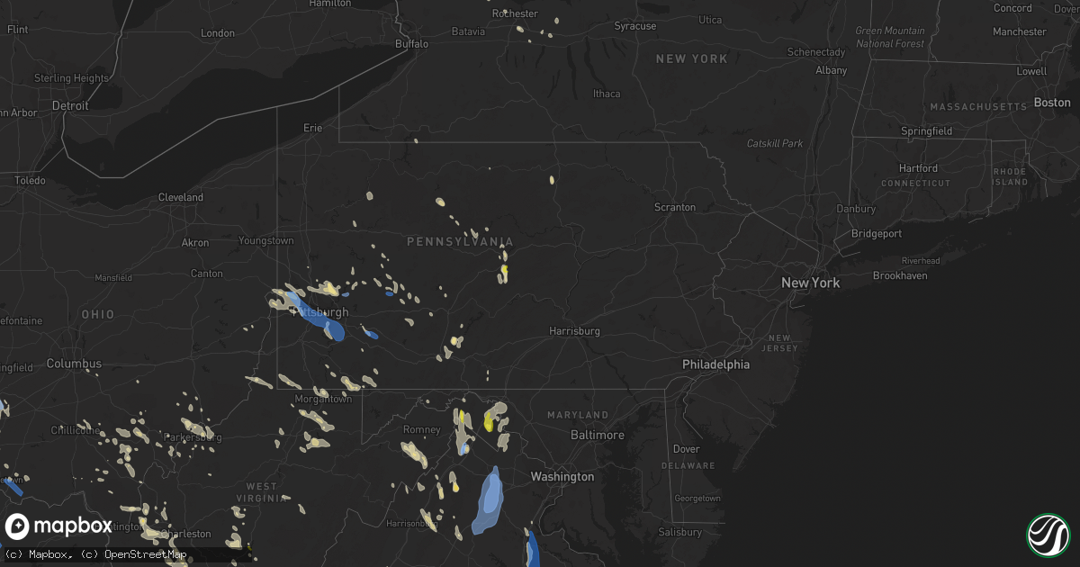
Hail Map in Pennsylvania on June 22, 2022
Get this storm
June 22 map
$229
one time, instant access
Download today. No call, no setup
Keep the $229
Bought the map and want the full workflow? Apply the entire $229 to a subscription within 7 days. None of it is wasted.
Every map, not just this one
This buys you this map. Subscription and you get every map we run, in the markets you choose from a few cities to whole states to nationwide. Plus real-time alerts the moment a storm fires.
Contact data
Name, contact info, occupancy, even credit band for addresses in the footprint. You go from where it hit to who to call.
Become the source they trust
Unlimited branding weather history reports on demand. You already have the documented answer ready for the property owner, and you are the one who showed up with it.
Property data and RoofTrace estimates
Pull up any address you have got, its value and the exact code rules for that jurisdiction, straight from One Click Code. Then RoofTrace estimates the squares, pitch, and roof value, priced the way you price.
Storm reports in Pennsylvania
Pennsylvania
| Date | Description |
|---|---|
| 06/22/20226:29 PM CDT | Numerous trees and wires down along route 26. |
| 06/22/20226:21 PM CDT | Trees down on wires. |
| 06/22/20226:19 PM CDT | Trees down on wires. |
| 06/22/20226:03 PM CDT | Numerous trees and wires down along bethel hollow road near the gravity hill. |
| 06/22/20225:46 PM CDT | Trees down on wires northeast of martinsburg. |
| 06/22/20225:42 PM CDT | Numerous trees on wires from south fork to summerhill. |
| 06/22/20225:42 PM CDT | Trees down on wires. |
| 06/22/20225:36 PM CDT | Trees down on wires. |
| 06/22/20225:34 PM CDT | Trees down blocking philippi road at johnson road west of garrett. |
| 06/22/20225:32 PM CDT | Reports of wind-induced power outage |
| 06/22/20225:30 PM CDT | Trees down on wires near ursina. |
| 06/22/20225:06 PM CDT | Tree limbs blown down |
| 06/22/20225:05 PM CDT | Trees blocking route 46 at old creek road. |
| 06/22/20225:00 PM CDT | Report of downed light poles. |
| 06/22/20225:00 PM CDT | Large tree down blocking roadway on fulton lane |
| 06/22/20225:00 PM CDT | Trees down on graham and hilltop road |
| 06/22/20224:48 PM CDT | Report of multiple trees snapped in half. Time estimated based on radar. |
| 06/22/20224:47 PM CDT | Trees down on wires. |
| 06/22/20224:36 PM CDT | Trees down |
| 06/22/20224:35 PM CDT | Trees down on wires across bullitt road. |
| 06/22/20224:30 PM CDT | Tree limbs down. Tree down blocing potato garden run rd. |
| 06/22/20224:30 PM CDT | Report and pictures of multiple trees down and uprooted. Time estimated based on radar. |
| 06/22/20224:30 PM CDT | Report of multiple large tree limbs snapped. Time estimated based on radar. |
| 06/22/20224:29 PM CDT | Trees down |
| 06/22/20224:25 PM CDT | Report of telephone poles snapped... Trees uprooted and snapped. Time estimated based on radar. |
| 06/22/20224:20 PM CDT | Several large branches and a tree down |
| 06/22/20224:20 PM CDT | Report of large of trees down across unity township. Time estimated based on radar. |
| 06/22/20224:20 PM CDT | A few trees down. |
| 06/22/20224:15 PM CDT | Trees down. Time estimate based on radar |
| 06/22/20224:13 PM CDT | Report of tree snapped in half. Time estimated based on radar. |
| 06/22/20224:12 PM CDT | Several trees down |
| 06/22/20224:10 PM CDT | Mobile home roof blew off |
| 06/22/20224:10 PM CDT | Gas pump blown over |
| 06/22/20224:08 PM CDT | Tree down at intersection of 9th / anchor ln |
| 06/22/20224:08 PM CDT | Report of large tree limb snapped along bownman avenue. Time estimated based on radar. |
| 06/22/20224:04 PM CDT | Power lines down |
| 06/22/20224:04 PM CDT | Several trees and wires down |
| 06/22/20224:02 PM CDT | Reports of wind-induced power outage |
| 06/22/20224:01 PM CDT | Power lines down |
| 06/22/20224:01 PM CDT | Power lines down |
| 06/22/20224:01 PM CDT | Large tree limbs down and power poles broken |
| 06/22/20224:00 PM CDT | Large tree limbs down |
| 06/22/20223:58 PM CDT | Report of medium sized tree felled along with other branches broken. Time estimated based on radar. |
| 06/22/20223:58 PM CDT | Several trees down blocking roadway |
| 06/22/20223:57 PM CDT | Tree down in east allegheny |
| 06/22/20223:55 PM CDT | Trees snapped or uprooted |
| 06/22/20223:52 PM CDT | A local report indicates 1.00 inch wind near 4 ENE BOALSBURG |
| 06/22/20223:50 PM CDT | Trees snapped or uprooted |
| 06/22/20223:50 PM CDT | Trees and wires blocking brush valley road west of centre hall. |
| 06/22/20223:50 PM CDT | Report of a destroyed swing set in west deer township. Time estimated based on radar. |
| 06/22/20223:43 PM CDT | Trees down along college ave near the i-99 on ramp. |
| 06/22/20223:40 PM CDT | A few trees down. |
| 06/22/20223:38 PM CDT | Report of tree blocking potato garden run road. Time estimated based on radar. |
| 06/22/20223:34 PM CDT | Multiple large trees down along shafer rd. Near stoops ferry/pa rt 51. Microburst occurred approximately 12 minutes after initial gust front passage... And was accompan |
| 06/22/20223:34 PM CDT | Multiple large trees down |
| 06/22/20223:30 PM CDT | Two large trees down |
| 06/22/20223:28 PM CDT | Trees and wires down on bocktown cork road |
| 06/22/20223:28 PM CDT | Reports of numerous trees down and damaged power lines. Time estimated based on radar. |
| 06/22/20223:25 PM CDT | Report of trees and wires down along kane road. Time estimated based on radar. |
| 06/22/20223:23 PM CDT | Four trees down along laura lane and robin rd. |
| 06/22/20223:22 PM CDT | Large tree blocking roadway |
| 06/22/20223:22 PM CDT | Wires down |
| 06/22/20223:20 PM CDT | Report of numerous trees downa cross lancaster township. Time estimated based on radar. |
| 06/22/20223:15 PM CDT | Power lines down |
| 06/22/20223:12 PM CDT | Trees and wires down on route 150 at deer field lane. |
| 06/22/20223:10 PM CDT | Trees down on woodward ave. |
| 06/22/20221:50 PM CDT | Tree down across road. |
| 06/22/20222:21 AM CDT | At 720 PM EDT, a severe thunderstorm was located over Clearville, moving southeast at 40 mph. HAZARD...60 mph wind gusts and quarter size hail. SOURCE...Radar indicated. IMPACT...Hail damage to vehicles is expected. Expect wind damage to roofs, siding, and trees. Locations impacted include... Bedford, Breezewood, Warfordsburg, Clearville, Everett, Crystal Springs, Needmore, Lake Gordon, Locust Grove, Barnes Gap, Inglesmith and Manns Choice.This includes the following Interstates... Interstate 70 from mile markers 147 to 170. The Pennsylvania Turnpike from mile markers 149 to 165. |
| 06/22/20221:58 AM CDT | At 658 PM EDT, a severe thunderstorm was located near Cameron, or 15 miles southeast of Moundsville, moving southeast at 30 mph. HAZARD...60 mph wind gusts. SOURCE...Radar indicated. IMPACT...Expect damage to trees and power lines, resulting in some power outages. Locations impacted include... Fairmont, Mannington, Barrackville, Cameron, Fairview, Hundred, Grant Town, Farmington, Worthington, New Freeport, McCurdyville, and Burton. |
| 06/22/20221:45 AM CDT | At 645 PM EDT, a severe thunderstorm was located over Ogletown, moving southeast at 40 mph. HAZARD...60 mph wind gusts and quarter size hail. SOURCE...Radar indicated. IMPACT...Hail damage to vehicles is expected. Expect wind damage to roofs, siding, and trees. Locations impacted include... Windber, Bedford, Roaring Spring, New Enterprise, Martinsburg, Everett, Claysburg, Osterburg, Davidsville, Central City, St. Clairsville and Blue Knob State Park.This includes the following Interstates... The Pennsylvania Turnpike between mile markers 132 and 151, and nearmile marker 153. Interstate 99 from mile markers 0 to 23. |
| 06/22/20221:26 AM CDT | At 625 PM EDT, severe thunderstorms were located along a line extending from Northern Cambria to Westmont, moving east at 20 mph. HAZARD...60 mph wind gusts and penny size hail. SOURCE...Radar indicated. IMPACT...Expect damage to roofs, siding, and trees. Locations impacted include... Johnstown, Westmont, Windber, Ebensburg, Belmont, Nanty-Glo, Portage, Northern Cambria, Geistown, Southmont, Patton and Cresson. |
| 06/22/202212:48 AM CDT | At 548 PM EDT, severe thunderstorms were located along a line extending from 6 miles west of Punxsutawney to 6 miles east of Ford City, moving southeast at 35 mph. HAZARD...60 mph wind gusts. SOURCE...Radar indicated. IMPACT...Expect damage to trees and power lines, resulting in some power outages. Locations impacted include... Punxsutawney, Clymer, Rural Valley, Big Run, Dayton, Chevy Chase Heights, Rossiter, Ernest, Marion Center, Cherry Tree, Elderton, and Creekside. |
| 06/22/202212:45 AM CDT | At 545 PM EDT, severe thunderstorms were located along a line extending from Keating Summit to St. Marys, moving southeast at 25 mph. HAZARD...60 mph wind gusts and quarter size hail. SOURCE...Radar indicated. IMPACT...Hail damage to vehicles is expected. Expect wind damage to roofs, siding, and trees. Locations impacted include... St. Marys, Cameron, Wharton, Emporium, Force, Benezette, Stevenson Dam, Elk River, Hicks Run, Keating Summit, Medix Run and Truman. |
| 06/22/202212:40 AM CDT | At 540 PM EDT, severe thunderstorms centered 7 miles southwest of Wintersville, or 9 miles southwest of Steubenville, moving southeast at 30 mph. HAZARD...60 mph wind gusts. SOURCE...Radar indicated. IMPACT...Expect damage to trees and power lines, resulting in some power outages. Locations impacted include... Wheeling, Steubenville, Martins Ferry, Cadiz, Warwood, Wellsburg, Bethlehem, West Liberty, Triadelphia, Clearview, Valley Grove, and Mingo Junction. |
| 06/22/202212:27 AM CDT | At 527 PM EDT, a severe thunderstorm was located over Leechburg, or over Vandergrift, moving southeast at 20 mph. HAZARD...60 mph wind gusts and quarter size hail. SOURCE...Radar indicated. IMPACT...Minor hail damage to vehicles is possible. Expect wind damage to trees and power lines, resulting in some power outages. Locations impacted include... Indiana, Vandergrift, Homer City, Apollo, New Kensington, Lower Burrell, Blairsville, Derry, Leechburg, Black Lick, North Apollo, and West Leechburg. |
| 06/22/202212:13 AM CDT | At 513 PM EDT, severe thunderstorms were located along a line extending from Bald Eagle State Park to Boalsburg, moving southeast at 20 mph. HAZARD...60 mph wind gusts and nickel size hail. SOURCE...Radar indicated. IMPACT...Expect damage to roofs, siding, and trees. Locations impacted include... State College, Lewistown, Bellefonte, Boalsburg, Pleasant Gap, Lemont, Burnham, Zion, Belleville, Houserville, Pine Grove Mills and Milroy.For those driving on Interstate 80, this includes areas between theSnow Shoe and Lamar exits, specifically from mile markers 155 to 166.This includes Interstate 99 from mile markers 74 to 85. |
| 06/22/202212:11 AM CDT | At 510 PM EDT, a severe thunderstorm was located over Lawson Heights, or over Latrobe, moving southeast at 25 mph. HAZARD...60 mph wind gusts. SOURCE...Radar indicated. IMPACT...Expect damage to trees and power lines, resulting in some power outages. Locations impacted include... Greensburg, Latrobe, McChesneytown-Loyalhanna, Derry, Lawson Heights, Ligonier, Seven Springs, Calumet-Norvelt, Youngstown, Laurel Mountain, Donegal, and Champion. |
| 06/22/202212:05 AM CDT | At 505 PM EDT, a severe thunderstorm was located 11 miles southeast of Carrollton, moving southeast at 30 mph. HAZARD...60 mph wind gusts. SOURCE...Radar indicated. IMPACT...Expect damage to trees and power lines, resulting in some power outages. Locations impacted include... Weirton, Steubenville, Wellsburg, Toronto, Wintersville, Mingo Junction, Follansbee, Hooverson Heights, New Cumberland, Salineville, Smithfield, and Franklin. |
| 06/22/202212:03 AM CDT | At 503 PM EDT, a severe thunderstorm was located over Shanor-Northvue, or near Butler, moving southeast at 15 mph. HAZARD...60 mph wind gusts. SOURCE...Radar indicated. IMPACT...Expect damage to trees and power lines, resulting in some power outages. Locations impacted include... Butler, Kittanning, Homeacre-Lyndora, Shanor-Northvue, Meridian, Meadowood, West Kittanning, Chicora, East Butler, Worthington, West Hills, and Applewold. |
| 06/22/202212:02 AM CDT | At 501 PM EDT, severe thunderstorms were centered near Mount Oliver, or over Pittsburgh, moving southeast at 30 mph. HAZARD...60 mph wind gusts. SOURCE...Radar indicated. IMPACT...Expect damage to trees and power lines, resulting in some power outages. Locations impacted include... Pittsburgh, Penn Hills, Mount Lebanon, Bethel Park, Ross Township, McCandless Township, Monroeville, McMurray, Greensburg, McKeesport, Jeannette, and Canonsburg. |
| 06/21/202211:53 PM CDT | At 453 PM EDT, a cluster of severe thunderstorms was centered near Knox, moving southeast at 30 mph. HAZARD...60 mph wind gusts. SOURCE...Radar indicated. IMPACT...Expect damage to trees and power lines, resulting in some power outages. Locations impacted include... Clarion, Brookville, Knox, New Bethlehem, Sligo, Strattanville, Summerville, Limestone, Hawthorn, Shippenville, Corsica, and Callensburg. |
| 06/21/202211:43 PM CDT | At 442 PM EDT, severe thunderstorms centered near Mars, or 8 miles east of Cranberry, are moving southeast at 30 mph. HAZARD...60 mph wind gusts. SOURCE...Radar indicated. IMPACT...Expect damage to trees and power lines, resulting in some power outages. Locations impacted include... Vandergrift, Apollo, Plum, Murrysville, Hampton Township, New Kensington, Lower Burrell, Harrison Township, Arnold, Tarentum, Natrona Heights, and Springdale. |
| 06/21/202211:36 PM CDT | At 436 PM EDT, a severe thunderstorm was located over Centre Hall, moving southeast at 20 mph. HAZARD...60 mph wind gusts and quarter size hail. SOURCE...Radar indicated. IMPACT...Hail damage to vehicles is expected. Expect wind damage to roofs, siding, and trees. Locations impacted include... Lewistown, Bellefonte, Boalsburg, Pleasant Gap, Lemont, Burnham, Zion, Houserville, Milroy, Highland Park, Centre Hall and Milesburg.For those driving on Interstate 80, this includes areas between theSnow Shoe and Lamar exits, specifically from mile markers 157 to 166.This includes Interstate 99 from mile markers 75 to 85. |
| 06/21/202211:26 PM CDT | At 425 PM EDT, a cluster of severes thunderstorm centered over Ambridge, or near Aliquippa, moving southeast at 30 mph. HAZARD...60 mph wind gusts. SOURCE...Radar indicated. IMPACT...Expect damage to trees and power lines, resulting in some power outages. Locations impacted include... Pittsburgh, Penn Hills, Mount Lebanon, Bethel Park, Ross Township, McCandless Township, Cranberry, Moon Township, McMurray, McKeesport, Franklin Park, and Aliquippa. |
| 06/21/202211:19 PM CDT | At 419 PM EDT, a severe thunderstorm was located over Arnot, moving south at 15 mph. HAZARD...60 mph wind gusts and quarter size hail. SOURCE...Radar indicated. IMPACT...Hail damage to vehicles is expected. Expect wind damage to roofs, siding, and trees. Locations impacted include... Blossburg and Arnot. |
| 06/21/202211:15 PM CDT | At 415 PM EDT, a severe thunderstorm was located near Zelienople, or 10 miles north of Cranberry, moving southeast at 20 mph. HAZARD...60 mph wind gusts. SOURCE...Radar indicated. IMPACT...Expect damage to trees and power lines, resulting in some power outages. Locations impacted include... Cranberry, Hampton Township, Homeacre-Lyndora, Meridian, Zelienople, Seven Fields, Gibsonia, Meadowood, Oak Hills, Evans City, Mars, and Saxonburg. |
| 06/21/202211:13 PM CDT | At 413 PM EDT, a severe thunderstorm was located 7 miles east of Tionesta, or 10 miles west of Marienville, moving southeast at 25 mph. HAZARD...60 mph wind gusts. SOURCE...Radar indicated. IMPACT...Expect damage to trees and power lines, resulting in some power outages. Locations impacted include... Marienville, Tionesta, Sigel, Kellettville, Leeper, Clarington, Clear Creek State Park, Cook Forest State Park, and Starr. |
| 06/21/202211:06 PM CDT | At 405 PM EDT, a severe thunderstorm was located over Avis, moving southeast at 20 mph. HAZARD...60 mph wind gusts and nickel size hail. SOURCE...Radar indicated. IMPACT...Expect damage to roofs, siding, and trees. Locations impacted include... Lock Haven, Carroll, Mill Hall, Avis, Dunnstown, Flemington, Castanea, McElhattan, Mackeyville, Loganton and Lock Haven University.For those driving on Interstate 80, this includes areas between theLamar and Mile Run exits, specifically from mile markers 174 to 194. |
| 06/21/202210:42 PM CDT | At 342 PM EDT, a severe thunderstorm was located near East Palestine, moving southeast at 20 mph. HAZARD...60 mph wind gusts. SOURCE...Radar indicated. IMPACT...Expect damage to trees and power lines, resulting in some power outages. Locations impacted include... Aliquippa, Beaver Falls, Monaca, East Palestine, Economy, Ambridge, New Brighton, Beaver, Calcutta, Baden, Rochester, and Ohioville. |
| 06/21/202210:25 PM CDT | At 325 PM EDT, a severe thunderstorm was located over Economy, or near Cranberry, moving southeast at 15 mph. HAZARD...60 mph wind gusts. SOURCE...Radar indicated. IMPACT...Expect damage to trees and power lines, resulting in some power outages. Locations impacted include... Pittsburgh, Penn Hills, Ross Township, McCandless Township, Cranberry, Franklin Park, Shaler Township, Hampton Township, Economy, O'hara Township, Bellevue, and Wexford. |
| 06/21/20229:56 PM CDT | At 255 PM EDT, severe thunderstorms were located along a line extending from near Manchester to Paramount-Long Meadow, moving south at 50 mph. HAZARD...60 mph wind gusts. SOURCE...Radar indicated. IMPACT...Damaging winds will cause some trees and large branches to fall. This could injure those outdoors, as well as damage homes and vehicles. Roadways may become blocked by downed trees. Localized power outages are possible. Unsecured light objects may become projectiles. Locations impacted include... Columbia, Germantown, Frederick, Hagerstown, Olney, Westminster, Damascus, Thurmont, Charles Town, Emmitsburg, Shepherdstown, Municipal Stadium, Harry Grove Stadium, Montgomery Village, Eldersburg, Ballenger Creek, Mount Airy, Robinwood, Taneytown and Brunswick. |
| 06/21/20229:28 PM CDT | At 228 PM EDT, a severe thunderstorm was located over Cashtown, moving south at 40 mph. HAZARD...60 mph wind gusts and nickel size hail. SOURCE...Radar indicated. IMPACT...Expect damage to roofs, siding, and trees. Locations impacted include... Waynesboro, Gettysburg, Carroll Valley, Fayetteville, Wayne Heights, Mont Alto, Scotland, Rouzerville, Cashtown, Orrtanna, Arendtsville and Fairfield.This includes Interstate 81 from mile markers 19 to 27. |
All States Impacted by Hail Map on June 22, 2022
Cities Impacted by Hail Map on June 22, 2022
- Bedford, PA
- Xenia, OH
- Jamestown, OH
- New Lexington, OH
- Somerset, OH
- Blossburg, PA
- Wellsboro, PA
- Clifton Springs, NY
- Shortsville, NY
- Caldwell, OH
- Macksburg, OH
- Dexter City, OH
- Greensburg, PA
- Benezett, PA
- Huntingdon, PA
- State College, PA
- Boalsburg, PA
- Markleysburg, PA
- Palmyra, NY
- Bloomingdale, OH
- Coolville, OH
- Guysville, OH
- Frenchville, PA
- Cumberland, MD
- Oldtown, MD
- Chillicothe, OH
- Philippi, WV
- Lost Creek, WV
- Bridgeport, WV
- Mount Clare, WV
- Brave, PA
- Blacksville, WV
- Spraggs, PA
- Holbrook, PA
- New Freeport, PA
- Aleppo, PA
- Wind Ridge, PA
- West Point, KY
- Cedar Grove, IN
- New Trenton, IN
- West Harrison, IN
- Brookville, IN
- South Webster, OH
- Minford, OH
- Bush, LA
- Covington, LA
- Franklinton, LA
- Cincinnati, OH
- Harrison, OH
- Burkesville, KY
- Henryville, IN
- Memphis, IN
- Borden, IN
- Hopewell, PA
- Saxton, PA
- Woodbury, PA
- Keedysville, MD
- Fairplay, MD
- Sharpsburg, MD
- Shepherdstown, WV
- Falling Waters, WV
- Boonsboro, MD
- Martinsburg, WV
- Kearneysville, WV
- Hagerstown, MD
- Williamsport, MD
- Gerrardstown, WV
- Clear Brook, VA
- Winchester, VA
- Berkeley Springs, WV
- Gore, VA
- Cross Junction, VA
- Stephenson, VA
- Glengary, WV
- Stephens City, VA
- Hedgesville, WV
- Wellington, KS
- Caldwell, KS
- Ray, OH
- South Bloomingville, OH
- McArthur, OH
- Londonderry, OH
- Oregonia, OH
- Clarksville, OH
- Milroy, IN
- Greensburg, IN
- Rushville, IN
- Bloomfield, IN
- Saint Marys, PA
- Hebron, KY
- North Bend, OH
- Addyston, OH
- Cleves, OH
- Latrobe, PA
- Newkirk, OK
- Mineral Wells, WV
- Flemington, WV
- Moatsville, WV
- Luray, VA
- Strasburg, VA
- Rileyville, VA
- Bentonville, VA
- Front Royal, VA
- Fort Valley, VA
- New Washington, IN
- Nabb, IN
- Charlestown, IN
- Westport, KY
- Marysville, IN
- Harpers Ferry, WV
- Shenandoah Junction, WV
- Halstead, KS
- Valley Center, KS
- Sedgwick, KS
- Bentley, KS
- Colwich, KS
- Aurora, IN
- Rising Sun, IN
- Romney, WV
- Shanks, WV
- Bidwell, OH
- Vinton, OH
- Gallipolis, OH
- Ganado, AZ
- Milton, WV
- Glenwood, WV
- Ashton, WV
- Greensburg, KS
- Haviland, KS
- Hickman, KY
- Union City, TN
- Duck, WV
- Nelsonville, OH
- New Marshfield, OH
- Elkton, VA
- Shenandoah, VA
- Harrisonburg, VA
- Broadway, VA
- Fisherville, KY
- Simpsonville, KY
- Patriot, IN
- Martin, TN
- Chester, WV
- Aliquippa, PA
- Oakdale, PA
- New Cumberland, WV
- Burgettstown, PA
- Industry, PA
- Midland, PA
- Hookstown, PA
- Georgetown, PA
- Imperial, PA
- Coraopolis, PA
- McDonald, PA
- Clinton, PA
- New Manchester, WV
- Crescent, PA
- Monaca, PA
- East Liverpool, OH
- Shippingport, PA
- Byrdstown, TN
- Louisville, KY
- Belpre, OH
- Fleming, OH
- Marietta, OH
- Stafford, KS
- Butler, KY
- Foster, KY
- Albany, OH
- Athens, OH
- Mullinville, KS
- Oak Hill, OH
- West Union, OH
- Seaman, OH
- Winchester, OH
- Wilkesville, OH
- Langsville, OH
- Kingman, KS
- Offerle, KS
- Bucklin, KS
- Willcox, AZ
- Warsaw, KY
- Lexington, IN
- Needham, AL
- Goshen, KY
- Crestwood, KY
- Prospect, KY
- Coldwater, KS
- Purgitsville, WV
- Baker, WV
- Rio, WV
- Old Fields, WV
- Moorefield, WV
- Buffalo, WV
- Culloden, WV
- Hamlin, WV
- Hurricane, WV
- Medicine Lodge, KS
- Nashville, KS
- Garden Plain, KS
- Andale, KS
- Newton, KS
- Goddard, KS
- Mount Hope, KS
- Isabel, KS
- Wilmore, KS
- Morgantown, WV
- Maidsville, WV
- Waverly, WV
- Crown City, OH
- Lesage, WV
- Fairfield, OH
- Hamilton, OH
- Batavia, OH
- Williamsburg, OH
- Sylvia, KS
- St John, KS
- Costa, WV
- Ridgeview, WV
- Ashford, WV
- Alum Creek, WV
- Nellis, WV
- Ona, WV
- Summersville, WV
- Drennen, WV
- Haven, KS
- Ebensburg, PA
- Colver, PA
- Cranberry, PA
- Knox, PA
- Waterford, OH
- Stockport, OH
- Adah, PA
- New Salem, PA
- McClellandtown, PA
- Bath, IN
- Oxford, OH
- Glouster, OH
- Griffithsville, WV
- Sod, WV
- Centre Hall, PA
- Bellefonte, PA
- Spivey, KS
- Norwich, KS
- Tornado, WV
- Saint Albans, WV
- Ivydale, WV
- Foster, WV
- Danville, WV
- Madison, WV
- Loysburg, PA
- Mercersburg, PA
- Altoona, PA
- Dysart, PA
- Howard, PA
- Brockport, NY
- Hamlin, NY
- Hilton, NY
- New Bethlehem, PA
- Milesburg, PA
- Okeana, OH
- Weedville, PA
- Lilly, PA
- Cassandra, PA
- Fredericksburg, VA
- Farmington, PA
- Bruceton Mills, WV
- Fairchance, PA
- Gibbon Glade, PA
- Jane Lew, WV
- Salem, WV
- Minneola, KS
- Milton, KY
- Pool, WV
- Quinwood, WV
- Mount Nebo, WV
- Wasco, CA
- Birch Tree, MO
- Winona, MO
- Bloomery, WV
- Great Cacapon, WV
- Greenville, VA
- Milam, WV
- Moundsville, WV
- Glen Easton, WV
- Proctor, WV
- Williamsville, MO
- Plevna, KS
- Dudley, MO
- Elk Horn, KY
- Columbia, KY
- Hacker Valley, WV
- Edinburg, VA
- Lucasville, OH
- Fairmont, WV
- Thornton, WV
- Bedford, KY
- Winfield, WV
- Eleanor, WV
- Scott Depot, WV
- Red House, WV
- Belle Plaine, KS
- Arkansas City, KS
- Oxford, KS
- Geuda Springs, KS
- South Haven, KS
- Honeoye Falls, NY
- Mendon, NY
- Pittsford, NY
- Madison, VA
- Rochelle, VA
- Vienna, WV
- Williamstown, WV
- Parkersburg, WV
- Clay, WV
- Victor, WV
- Swiss, WV
- Seth, WV
- Peytona, WV
- Dayton, PA
- White, PA
- Scottdale, PA
- Acme, PA
- Indiana, PA
- Coudersport, PA
- Markleton, PA
- Confluence, PA
- Lowell, OH
- Beverly, OH
- Jackson, OH
- Wallace, WV
- Clarksburg, WV
- Frankfort, OH
- Lovettsville, VA
- Purcellville, VA
- Charles Town, WV
- Round Hill, VA
- Moores Hill, IN
- Dillsboro, IN
- Elizabeth, IN
- Laconia, IN
- North Vernon, IN
- Scipio, IN
- Westport, IN
- Stafford, VA
- Fulks Run, VA
- Bergton, VA
- Corydon, IN
- Apple Grove, WV
- Fraziers Bottom, WV
- Orgas, WV
- Comfort, WV
- Spout Spring, VA
- Red House, VA
- Appomattox, VA
- Concord, VA
- Addison, PA
- West Hamlin, WV
- Scottown, OH
- Cubero, NM
- Bloomfield, NY
- Victor, NY
- Pittsburgh, PA
- Fallentimber, PA
- Walker, WV
- Newport, OH
- Saint Marys, WV
- Tarentum, PA
- Saxonburg, PA
- Gibsonia, PA
- Russellton, PA
- Valencia, PA
- Cheswick, PA
- Bairdford, PA
- Belleville, WV
- Ravenswood, WV
- Butlerville, IN
- Glassport, PA
- Mckeesport, PA
- Elrama, PA
- Dravosburg, PA
- Clairton, PA
- Webster, PA
- Monongahela, PA
- Finleyville, PA
- West Mifflin, PA
- West Elizabeth, PA
- Belle Vernon, PA
- Elizabeth, PA
- Deputy, IN
- Long Bottom, OH
- Reedsville, OH
- Breeding, KY
- North Newton, KS
- Walton, KS
- Hardtner, KS
- Monterville, WV
- Pickens, WV
- Sardinia, OH
- Madison, IN
- Masonic Home, KY
- New Albany, IN
- Jeffersonville, IN
- Clarksville, IN
- South Charleston, WV
- Georgetown, IN
- Lanesville, IN
- Pratt, KS
- Conway Springs, KS
- Grandin, MO
- Vincent, OH
- Reno, OH
- Ambridge, PA
- Baden, PA
- Beaver, PA
- Freedom, PA
- Sewickley, PA
- Shubuta, MS
- Vossburg, MS
- Vail, AZ
- Elgin, AZ
- Julian, WV
- Alkol, WV
- Yawkey, WV
- Russellville, OH
- Georgetown, OH
- Sanders, KY
- Vevay, IN
- Worthville, KY
- Ghent, KY
- Inman, KS
- Twilight, WV
- Jeffrey, WV
- Racine, WV
- Bob White, WV
- Gordon, WV
- Bim, WV
- Van, WV
- Dexter, KS
- Maple City, KS
- Scottsburg, IN
- Underwood, IN
- Grafton, WV
- Independence, WV
- Homer City, PA
- Penn Run, PA
- Wilmington, OH
- Ford City, PA
- Bulger, PA
- Petersburg, KY
- Hanover, IN
- Kendall, NY
- Holley, NY
- Home, PA
- Clymer, PA
- Marion Center, PA
- Martinsburg, PA
- Lansing, WV
- Lookout, WV
- Edmond, WV
- Waterloo, OH
- Smithfield, PA
- Uniontown, PA
- Masontown, PA
- La Grange, KY
- Newburg, WV
- Farmington, WV
- Barrackville, WV
- Tunnelton, WV
- Pomeroy, OH
- Winfield, KS
- Waterport, NY
- Aroda, VA
- Pratts, VA
- New Middletown, IN
- Murdock, KS
- Bogalusa, LA
- Milan, KS
- Argonia, KS
- Springville, TN
- Buchanan, TN
- Big Sandy, TN
- Pewee Valley, KY
- Maize, KS
- Vandergrift, PA
- Leechburg, PA
- Fort Hill, PA
- Everett, PA
- Creighton, PA
- Bakerstown, PA
- Commodore, PA
- Lost City, WV
- Wardensville, WV
- Hamden, OH
- Kingston, OH
- Woodford, VA
- Glens Fork, KY
- Mayfield, KS
- Trenton, OH
- Gloster, MS
- Anacoco, LA
- Willow Wood, OH
- Hutchinson, KS
- Partridge, KS
- Pickerington, OH
- Carroll, OH
- Adena, OH
- Cadiz, OH
- Rockport, WV
- West College Corner, IN
- Harmony, PA
- Paris Crossing, IN
- Wallback, WV
- Nebo, WV
- Nitro, WV
- Charleston, WV
- Palestine, WV
- Creston, WV
- Leon, WV
- Cranberry Township, PA
- Allison Park, PA
- Mars, PA
- Bradfordwoods, PA
- Wexford, PA
- Natrona Heights, PA
- Sarver, PA
- Warrendale, PA
- Guilford, IN
- Lawrenceburg, IN
- Bellbrook, OH
- Spring Valley, OH
- Port William, OH
- Dayton, OH
- Waynesville, OH
- Owensville, OH
- Fayetteville, OH
- Mount Orab, OH
- Blanchester, OH
- Quicksburg, VA
- Mount Jackson, VA
- Basye, VA
- Turon, KS
- Iuka, KS
- Castlewood, VA
- Lebanon, VA
- Evans City, PA
- Newark, NY
- New Enterprise, PA
- Rochester, NY
- Campbellsburg, KY
- Kittanning, PA
- Worthington, PA
- Midland, OH
- Bradford, PA
- Salamanca, NY
- Woodstock, VA
- Marienville, PA
- Tionesta, PA
- Karthaus, PA
- Canal Winchester, OH
- Leesville, LA
- Elizabeth, WV
- Petroleum, WV
- Mayport, PA
- Punxsutawney, PA
- Timblin, PA
- Kent, NY
- Lebanon, OH
- Poplar Bluff, MO
- Creekside, PA
- Shelocta, PA
- Rural Valley, PA
- Millfield, OH
- Chauncey, OH
- Belva, WV
- Madera, CA
- Cameron, WV
- Clarington, OH
- Powhatan Point, OH
- Parkhill, PA
- Johnstown, PA
- Washington, WV
- Creola, OH
- Zaleski, OH
- New Plymouth, OH
- Stanley, VA
- Carrollton, KY
- Sparta, KY
- Mesquite, NM
- Osage, WV
- Mount Morris, PA
- Dilliner, PA
- Stewart, OH
- Pottersdale, PA
- Freeport, PA
- Whipple, OH
- Lower Salem, OH
- Mannington, WV
- Northern Cambria, PA
- Shade, OH
- Russell Springs, KY
- Puxico, MO
- Wappapello, MO
- Abbyville, KS
- Syria, VA
- Union, KY
- Walton, KY
- Verona, KY
- Vidalia, LA
- Otisco, IN
- Sellersburg, IN
- Peck, KS
- Manchester, OH
- Vanceburg, KY
- Ripley, OH
- Buena Vista, PA
- Yukon, PA
- Herminie, PA
- Smithton, PA
- Bridgeville, PA
- Carnegie, PA
- Homestead, PA
- Greenock, PA
- Presto, PA
- Bethel Park, PA
- South Park, PA
- Lowber, PA
- West Newton, PA
- Duquesne, PA
- Rillton, PA
- McKees Rocks, PA
- Irwin, PA
- Wyano, PA
- Sutersville, PA
- New Kensington, PA
- Ligonier, PA
- Ranson, WV
- Inwood, WV
- Mauckport, IN
- Fort Knox, KY
- Bardstown, KY
- Boston, KY
- Lebanon Junction, KY
- Shepherdsville, KY
- Olympia, KY
- Carlisle, KY
- Sharpsburg, KY
- Moorefield, KY
- Owingsville, KY
- Laurel, IN
- Fort Lee, VA
- Henrico, VA
- Petersburg, VA
- Bowling Green, VA
- Sandston, VA
- Ashland, VA
- Richmond, VA
- Milford, VA
- Mechanicsville, VA
- Ruther Glen, VA
- Prince George, VA
- King George, VA
- Disputanta, VA
- Chesterfield, VA
- Hanover, VA
- Port Royal, VA
- Hopewell, VA
- Colonial Heights, VA
- Chester, VA
- Glen Allen, VA
- Doswell, VA
- Mitchells, VA
- Culpeper, VA
- Elkwood, VA
- Marshall, VA
- Stevensburg, VA
- Reva, VA
- Delaplane, VA
- Brandy Station, VA
- Brightwood, VA
- Hume, VA
- Midland, VA
- Warrenton, VA
- Remington, VA
- Castleton, VA
- The Plains, VA
- Amissville, VA
- Rapidan, VA
- Rixeyville, VA
- Jeffersonton, VA
- Upperville, VA
- Broad Run, VA
- Locust Dale, VA
- Bealeton, VA


