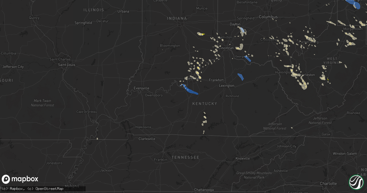
Hail Map in Kentucky on June 22, 2022
Get this storm
June 22 map
$229
one time, instant access
Download today. No call, no setup
Keep the $229
Bought the map and want the full workflow? Apply the entire $229 to a subscription within 7 days. None of it is wasted.
Every map, not just this one
This buys you this map. Subscription and you get every map we run, in the markets you choose from a few cities to whole states to nationwide. Plus real-time alerts the moment a storm fires.
Contact data
Name, contact info, occupancy, even credit band for addresses in the footprint. You go from where it hit to who to call.
Become the source they trust
Unlimited branding weather history reports on demand. You already have the documented answer ready for the property owner, and you are the one who showed up with it.
Property data and RoofTrace estimates
Pull up any address you have got, its value and the exact code rules for that jurisdiction, straight from One Click Code. Then RoofTrace estimates the squares, pitch, and roof value, priced the way you price.
Storm reports in Kentucky
Kentucky
| Date | Description |
|---|---|
| 06/22/20226:43 PM CDT | Branch fell on camper...two people inside were extricated by ems. Unknown if any injuries. Also...one tree down in town. |
| 06/22/20226:40 PM CDT | Tree down on hwy 1000. |
| 06/22/20226:35 PM CDT | Tree down on hwy 191. |
| 06/22/20226:28 PM CDT | A large tree limb was blown down onto stamper branch. |
| 06/22/20226:15 PM CDT | Trees down. |
| 06/22/20226:12 PM CDT | Report from 911 dispatch stating a tree was down on calaboose ridge road. Time estimated from radar. |
| 06/22/20226:12 PM CDT | Received report on social media of four trees down and blocking the road near exit 48 on the mountain parkway. Time estimated from radar. |
| 06/22/20226:10 PM CDT | Corrects previous tstm wnd dmg report from 2 se stanton. Tree reported down at the 2000 block of furnace road in stanton... Ky. Time estimated via radar. |
| 06/22/20226:08 PM CDT | Received report from 911 dispatch stating multiple trees were down on glencarin road in rogers... Ky. Time estimated from radar. |
| 06/22/20226:08 PM CDT | Report from 911 dispatch stating a tree came down on hiram branch road. The tree fell on a power line... Taking out power to nearby customers. Time estimated from radar |
| 06/22/20226:08 PM CDT | Power lines down. |
| 06/22/20226:07 PM CDT | Tree down. |
| 06/22/20226:06 PM CDT | Tree reported down near the 1900 block of pilot road in stanton... Ky. Time estimated via radar. |
| 06/22/20226:00 PM CDT | Tree reported down on ky-60 just outside salt lick. |
| 06/22/20225:55 PM CDT | Tree reported down along ky-111. |
| 06/22/20225:35 PM CDT | A tree was reported down at 1342 indian mound drive. The tree fell on an electric line... But power was not out. Time estimated from radar and observation in mount ster |
| 06/22/20225:35 PM CDT | Tree reported down at the intersection of stepstone and turley road. |
| 06/22/20225:35 PM CDT | Tree reported down on 1675 fogg pike. |
| 06/22/20225:35 PM CDT | Tree reported down at the intersection of step and wires down along route 26. |
| 06/22/20225:30 PM CDT | Tree reported down on 210 rogers avenue. |
| 06/22/20225:30 PM CDT | 911 center reported a tree was down on levee road bypass. The tree was on an electric line but power did not go out. Time estimated from radar and observation in mount |
| 06/22/20225:30 PM CDT | Tree reported down at the intersection of howards mill road and stepstone mill road. |
| 06/22/20225:30 PM CDT | Report of a few large tree limbs removed along ky-11 near mm 1. Time estimated from radar. |
| 06/22/20225:25 PM CDT | Tree reported down at the intersection of midland trail and hinkston pike. |
| 06/22/20225:25 PM CDT | Multiple trees reported down at 3991 grassy lick road. |
| 06/22/20225:25 PM CDT | Multiple trees reported down at 3298 prewitt-grassy lick road. |
| 06/22/20225:20 PM CDT | Several trees down in the tollesboro area. Time estimated by radar. |
| 06/22/20225:06 PM CDT | Trees down on bethany rd. |
| 06/22/20225:05 PM CDT | Tree down on e union rd. |
| 06/22/20225:05 PM CDT | Tree down on e union rd. Stone and turley road. |
| 06/22/20225:00 PM CDT | Several trees down... Blocking multiple roads in mason county. This includes clarks run... Kentucky route 8 and parker road. Time estimated from radar to be between 555 |
| 06/22/20224:55 PM CDT | Tree down on clear creek rd. |
| 06/22/20224:55 PM CDT | Tree down at shadynook pike and shaw ln. |
| 06/22/20224:55 PM CDT | Tress down on delaney ferry rd. |
| 06/22/20224:55 PM CDT | A few trees were downed along state route 10. Time estimated by radar. |
| 06/22/20224:53 PM CDT | Tree down on 62e. |
| 06/22/20224:45 PM CDT | Tree down on state hwy 1284 w. |
| 06/22/20224:40 PM CDT | Tree down on ky hwy 1032 w. |
| 06/22/20224:30 PM CDT | A few trees were downed along state route 8. Time estimated by radar. |
| 06/22/20224:30 PM CDT | Several trees down throughout pendleton county. Time estimated by radar to have occured between 525 pm and 535 pm. |
| 06/22/20224:30 PM CDT | Trees down on back creek rd. |
| 06/22/20224:17 PM CDT | Trees down at cropper rd and eminence pike. |
| 06/22/20224:17 PM CDT | Trees down at cropper rd and eminence pike. |
| 06/22/20224:15 PM CDT | Trees down on fox run rd. |
| 06/22/20224:09 PM CDT | Portion of roof removed from a distillery building. Time estimated based on radar. |
| 06/22/20224:05 PM CDT | Trees in power lines on todds point rd. |
| 06/22/20224:05 PM CDT | Trees in power lines on buck creek rd. |
| 06/22/20223:50 PM CDT | Report of a tree down across hudson lane near st. Gabriel church. Time estimated from radar. |
| 06/22/20223:50 PM CDT | A few trees down in the warsaw area. Time estimated by radar. |
| 06/22/20223:35 PM CDT | Trees down on i-71s at exit 2 onto zorn avenue and on the va hospital property. |
| 06/22/20223:32 PM CDT | Report of trees and power lines down along bluegrass parkway. Time estimated from radar. |
| 06/22/20223:30 PM CDT | Tree down on house. |
| 06/22/20223:27 PM CDT | Numerous trees down across the county |
| 06/22/20223:27 PM CDT | Trees down on grinstead dr near i-64. |
| 06/22/20223:26 PM CDT | Barn roof peeled off. |
| 06/22/20223:25 PM CDT | Trees and powerlines down on the 5300 block of w hwy 524. |
| 06/22/20223:21 PM CDT | Two trees down... One on a house and another on a car |
| 06/22/20223:15 PM CDT | Trees down on rose island rd. |
| 06/22/20223:27 AM CDT | At 827 PM EDT, a severe thunderstorm was located over Toulouse, or near Hyden, moving southeast at 35 mph. HAZARD...60 mph wind gusts and penny size hail. SOURCE...Radar indicated. IMPACT...Expect damage to roofs, siding, and trees. This severe thunderstorm will be near... Avawam around 830 PM EDT. Frew around 835 PM EDT. Daley around 840 PM EDT. Viper around 845 PM EDT.Other locations in the path of this severe thunderstorm include Daisyand Slemp. |
| 06/22/20222:20 AM CDT | At 720 PM EDT, severe thunderstorms were located along a line extending from Lenox to Trent, moving east at 40 mph. HAZARD...60 mph wind gusts. SOURCE...Radar indicated. IMPACT...Expect damage to roofs, siding, and trees. Severe thunderstorms will be near... Elamton around 725 PM EDT. Silverhill around 730 PM EDT. Burkhart around 735 PM EDT. Dale around 740 PM EDT.Other locations in the path of these severe thunderstorms includeEugene. |
| 06/22/20222:07 AM CDT | At 706 PM CDT, severe thunderstorms were from 7 miles east of Burkesville to 7 miles northeast of Celina, moving southeast at 15 mph. HAZARD...60 mph wind gusts and nickel size hail. SOURCE...Radar indicated. IMPACT...Expect damage to roofs, siding, and trees. Locations impacted include... Albany, Littrell, Snow, Savage, Highway, Ida, Modoc, Green Grove, Rolan, and Decide. |
| 06/22/20221:59 AM CDT | At 658 PM EDT, a severe thunderstorm was located over Fagan, or near Frenchburg, moving east at 35 mph. HAZARD...60 mph wind gusts. SOURCE...Radar indicated. IMPACT...Expect damage to roofs, siding, and trees. This severe thunderstorm will be near... Frenchburg around 710 PM EDT. Denniston around 715 PM EDT.Other locations in the path of this severe thunderstorm includeWellington, Ebon and Kellacey. |
| 06/22/20221:42 AM CDT | At 642 PM EDT, a severe thunderstorm was located 7 miles north of Boone, moving southeast at 30 mph. HAZARD...60 mph wind gusts and nickel size hail. SOURCE...Radar indicated. IMPACT...Expect damage to roofs, siding, and trees. Locations impacted include... Richmond, Berea, Silver Creek, Caleast, Duluth, Peytontown, Bighill, Kingston, Whites, and Buggytown. |
| 06/22/20221:34 AM CDT | At 633 PM CDT, severe thunderstorms were from 8 miles northwest of Jamestown to 13 miles northwest of Cabell to near Burkesville, moving southeast at 25 mph.Trees and power lines were reported down with these storms in Adair County. HAZARD...60 mph wind gusts and quarter size hail. SOURCE...Radar indicated. IMPACT...Hail damage to vehicles is expected. Expect wind damage to roofs, siding, and trees. Locations impacted include... Jamestown, Burkesville, Russell Springs, Desda, Eli, Snow, Cundiff, Ida, Royville, and Sano. |
| 06/22/20221:21 AM CDT | At 620 PM EDT, a severe thunderstorm was located over Carlisle, or 16 miles north of Mount Sterling, moving southeast at 20 mph. HAZARD...60 mph wind gusts. SOURCE...Radar indicated. IMPACT...Expect damage to roofs, siding, and trees. This severe thunderstorm will be near... Sharpsburg around 640 PM EDT.Other locations in the path of this severe thunderstorm includeStoops and Flat Creek. |
| 06/22/20221:18 AM CDT | At 618 PM EDT, a severe thunderstorm was located over Clarktown, moving southeast at 30 mph. HAZARD...60 mph wind gusts and penny size hail. SOURCE...Radar indicated. IMPACT...Expect damage to trees and power lines. Locations impacted include... Portsmouth, Wheelersburg, New Boston, South Webster, Rosemount, Clarktown, Lucasville, Sciotodale, Portsmouth Regional Airport, Minford, Lyra and Sciotoville. |
| 06/22/20221:14 AM CDT | At 614 PM EDT, severe thunderstorms were located from 10 miles north of Rome to Maysville, moving southeast at 20 mph. HAZARD...60 mph wind gusts. SOURCE...Radar indicated. IMPACT...Expect damage to trees and power lines. Locations impacted include... Maysville, Washington, Manchester, Vanceburg, Tollesboro, Rome, Blue Creek, Concord, Trinity, Saint Paul, Rectorville, Epworth, Ribolt, Friendship, Charters, Sandy Springs, Buena Vista in Scioto County, Firebrick, Carrs and State Route 348 at State Route 125. |
| 06/22/20221:08 AM CDT | At 607 PM CDT, severe thunderstorms were from 12 miles southeast of Campbellsville to 10 miles east of Edmonton, moving southeast at 20 mph. HAZARD...60 mph wind gusts and quarter size hail. SOURCE...Radar indicated. IMPACT...Hail damage to vehicles is expected. Expect wind damage to roofs, siding, and trees. Locations impacted include... Columbia, Christine, Cundiff, Gadberry, Absher, Sano, Bliss, Fairplay, Flatwood and Gentrys Mill. |
| 06/22/202212:59 AM CDT | At 559 PM EDT, severe thunderstorms were located along a line extending from Aberdeen to 6 miles east of Cynthiana, moving southeast at 45 mph. HAZARD...60 mph wind gusts and penny size hail. SOURCE...Radar indicated. IMPACT...Expect damage to roofs, siding, and trees. These severe thunderstorms will remain over mainly rural areas of northern Fleming County, including the following locations... Ewing. |
| 06/22/202212:56 AM CDT | At 556 PM EDT, a severe thunderstorm was located 9 miles northeast of Cynthiana, moving southeast at 45 mph. HAZARD...60 mph wind gusts and penny size hail. SOURCE...Radar indicated. IMPACT...Expect damage to roofs, siding, and trees. Locations impacted include... Carlisle, Jackstown, Oddville, Ellisville, Pleasant Valley, Headquarters, Claysville, Moorefield, Myers, and Barefoot. |
| 06/22/202212:49 AM CDT | At 549 PM EDT, severe thunderstorms were located along a line extending from 10 miles south of Lawrenceburg to 12 miles southeast of Taylorsville, moving southeast at 25 mph. HAZARD...60 mph wind gusts and quarter size hail. SOURCE...Radar indicated. IMPACT...Hail damage to vehicles is expected. Expect wind damage to roofs, siding, and trees. Locations impacted include... Harrodsburg, Ballard, Burgin, Willisburg, Mackville, Tablow, Dugansville, Talmage, Cornishville, and Riverview Estates. |
| 06/22/202212:45 AM CDT | At 545 PM EDT, severe thunderstorms were located from 7 miles southeast of Brooksville to 10 miles northeast of Cynthiana, moving southeast at 25 mph. HAZARD...60 mph wind gusts. SOURCE...Radar indicated. IMPACT...Expect damage to trees and power lines. Locations impacted include... Lewisburg, Mount Olivet, Sardis, US Route 62 at State Route 875, Blue Licks Battlefield, Abigail, Murphysville, Burika, Alhambra, Stonewall, Mays Lick, Mitchells Mill, Santa Fe, Peed, Fleming-Mason Airport, Lowell, Helena, Kentontown, Piqua and US Route 62 at State Route 616. |
| 06/22/202212:40 AM CDT | At 539 PM EDT, a severe thunderstorm was located near Mount Orab, moving southeast at 25 mph. HAZARD...60 mph wind gusts. SOURCE...Radar indicated. IMPACT...Expect damage to trees and power lines. Locations impacted include... Maysville, Georgetown, Mount Orab, West Union, Ripley, Aberdeen, Sardinia, Decatur, Russellville, Hamersville, Dover, Redoak, Moranburg, Lake Waynoka, Bradysville, Bentonville, South Ripley, Tuckahoe, New Hope and Locust Ridge. |
| 06/22/202212:34 AM CDT | At 533 PM EDT, a severe thunderstorm was located near Falmouth, moving southeast at 35 mph. HAZARD...60 mph wind gusts and quarter size hail. SOURCE...Radar indicated. IMPACT...Hail damage to vehicles is expected. Expect wind damage to roofs, siding, and trees. Locations impacted include... Cynthiana, Berry, Robinson, Colemansville, Oddville, Boyd, Claysville, Antioch, Garnett, and Kelat. |
| 06/21/202211:59 PM CDT | At 459 PM EDT, severe thunderstorms were located along a line extending from near Middletown to Pioneer Village to near Shepherdsville, moving east at 25 mph. HAZARD...60 mph wind gusts and penny size hail. SOURCE...Radar indicated. IMPACT...Expect damage to roofs, siding, and trees. Locations impacted include... Jeffersontown, Shepherdsville, Pioneer Village, Hollow Creek, Hollyvilla, Spring Mill, Highview, Fern Creek, Okolona and Minor Lane Heights. |
| 06/21/202211:46 PM CDT | At 445 PM EDT, severe thunderstorms were from near Bedford to La Grange to near Middletown, moving southeast at 15 mph. HAZARD...60 mph wind gusts and nickel size hail. SOURCE...Radar indicated. IMPACT...Expect damage to roofs, siding, and trees. Locations impacted include... Shelbyville, La Grange, Middletown, New Castle, Pendleton, Crestwood, Eminence, Simpsonville, Pewee Valley and Campbellsburg. |
| 06/21/202211:36 PM CDT | At 436 PM EDT, a severe thunderstorm was located near Vevay, moving east at 30 mph. HAZARD...60 mph wind gusts. SOURCE...Radar indicated. IMPACT...Expect damage to trees and power lines. Locations impacted include... Vevay, Warsaw, Florence, Kentucky Speedway, Glencoe, Ghent, Sanders, Sparta, Ethridge, Munk, Interstate 71 at Mile Marker 52, Interstate 71 at US Route 127, Markland, Eagle Hill, Napoleon, Twin Bridges, Needmore, Holbrook, US Route 42 at State Route 184 and Elliston.This includes I-71 in Kentucky between mile markers 50 and 67. |
| 06/21/202211:14 PM CDT | At 414 PM EDT, a severe thunderstorm was located over Harrison, moving southeast at 20 mph. HAZARD...60 mph wind gusts and quarter size hail. SOURCE...Radar indicated. IMPACT...Minor hail damage to vehicles is possible. Expect wind damage to trees and power lines. Locations impacted include... Cincinnati, Harrison, Cheviot, Cleves, Shawnee, Taylor Creek, Bridgetown, Delhi Township, Miami Heights, Blue Jay, University of Cincinnati, Monfort Heights, Mack, Delhi Hills, New Haven, Grandview, Addyston, North Bend, West Harrison and Dent.This includes the following Interstates... I-71 in Ohio between mile markers 3 and 4. I-74 in Ohio between mile markers 1 and 19. I-75 in Ohio between mile markers 2 and 6. |
| 06/21/202210:54 PM CDT | At 353 PM EDT, severe thunderstorms were from near Scottsburg to 14 miles northwest of Prospect to 12 miles northwest of New Albany, moving east at 20 mph. HAZARD...60 mph wind gusts and quarter size hail. SOURCE...Radar indicated. IMPACT...Hail damage to vehicles is expected. Expect wind damage to roofs, siding, and trees. Locations impacted include... New Albany, Clarksville, Charlestown, Sellersburg, Lexington, Owen, Borden, Saint Joseph, Henryville, and Starlight. |
| 06/21/202210:50 PM CDT | At 350 PM EDT, a severe thunderstorm was located 7 miles southwest of Madison, moving southeast at 25 mph. HAZARD...60 mph wind gusts and quarter size hail. SOURCE...Radar indicated. IMPACT...Hail damage to vehicles is expected. Expect wind damage to roofs, siding, and trees. Locations impacted include... Bedford, Hanover, Saluda, Bethlehem, Milton, Monitor, Otto, Trout, Paynesville, and Hanover Beach. |
| 06/21/20229:33 PM CDT | Tree reported down at the 2000 block of furnace road in stanton... Ky. Time estimated via radar. |
| 06/21/20228:05 PM CDT | Tree fell on a house on parker street. |
| 06/21/20227:45 PM CDT | Tree down on ky-7. Time estimated by radar. |
| 06/21/20227:45 PM CDT | Tree down on right fork maces creek road. |
| 06/21/20227:40 PM CDT | Powerline down near the dollar general on cutshin road. Power outages have been reported throughout the surrounding area. |
| 06/21/20227:10 PM CDT | Tree down on bowlin road. |
All States Impacted by Hail Map on June 22, 2022
Cities Impacted by Hail Map on June 22, 2022
- Bedford, PA
- Xenia, OH
- Jamestown, OH
- New Lexington, OH
- Somerset, OH
- Blossburg, PA
- Wellsboro, PA
- Clifton Springs, NY
- Shortsville, NY
- Caldwell, OH
- Macksburg, OH
- Dexter City, OH
- Greensburg, PA
- Benezett, PA
- Huntingdon, PA
- State College, PA
- Boalsburg, PA
- Markleysburg, PA
- Palmyra, NY
- Bloomingdale, OH
- Coolville, OH
- Guysville, OH
- Frenchville, PA
- Cumberland, MD
- Oldtown, MD
- Chillicothe, OH
- Philippi, WV
- Lost Creek, WV
- Bridgeport, WV
- Mount Clare, WV
- Brave, PA
- Blacksville, WV
- Spraggs, PA
- Holbrook, PA
- New Freeport, PA
- Aleppo, PA
- Wind Ridge, PA
- West Point, KY
- Cedar Grove, IN
- New Trenton, IN
- West Harrison, IN
- Brookville, IN
- South Webster, OH
- Minford, OH
- Bush, LA
- Covington, LA
- Franklinton, LA
- Cincinnati, OH
- Harrison, OH
- Burkesville, KY
- Henryville, IN
- Memphis, IN
- Borden, IN
- Hopewell, PA
- Saxton, PA
- Woodbury, PA
- Keedysville, MD
- Fairplay, MD
- Sharpsburg, MD
- Shepherdstown, WV
- Falling Waters, WV
- Boonsboro, MD
- Martinsburg, WV
- Kearneysville, WV
- Hagerstown, MD
- Williamsport, MD
- Gerrardstown, WV
- Clear Brook, VA
- Winchester, VA
- Berkeley Springs, WV
- Gore, VA
- Cross Junction, VA
- Stephenson, VA
- Glengary, WV
- Stephens City, VA
- Hedgesville, WV
- Wellington, KS
- Caldwell, KS
- Ray, OH
- South Bloomingville, OH
- McArthur, OH
- Londonderry, OH
- Oregonia, OH
- Clarksville, OH
- Milroy, IN
- Greensburg, IN
- Rushville, IN
- Bloomfield, IN
- Saint Marys, PA
- Hebron, KY
- North Bend, OH
- Addyston, OH
- Cleves, OH
- Latrobe, PA
- Newkirk, OK
- Mineral Wells, WV
- Flemington, WV
- Moatsville, WV
- Luray, VA
- Strasburg, VA
- Rileyville, VA
- Bentonville, VA
- Front Royal, VA
- Fort Valley, VA
- New Washington, IN
- Nabb, IN
- Charlestown, IN
- Westport, KY
- Marysville, IN
- Harpers Ferry, WV
- Shenandoah Junction, WV
- Halstead, KS
- Valley Center, KS
- Sedgwick, KS
- Bentley, KS
- Colwich, KS
- Aurora, IN
- Rising Sun, IN
- Romney, WV
- Shanks, WV
- Bidwell, OH
- Vinton, OH
- Gallipolis, OH
- Ganado, AZ
- Milton, WV
- Glenwood, WV
- Ashton, WV
- Greensburg, KS
- Haviland, KS
- Hickman, KY
- Union City, TN
- Duck, WV
- Nelsonville, OH
- New Marshfield, OH
- Elkton, VA
- Shenandoah, VA
- Harrisonburg, VA
- Broadway, VA
- Fisherville, KY
- Simpsonville, KY
- Patriot, IN
- Martin, TN
- Chester, WV
- Aliquippa, PA
- Oakdale, PA
- New Cumberland, WV
- Burgettstown, PA
- Industry, PA
- Midland, PA
- Hookstown, PA
- Georgetown, PA
- Imperial, PA
- Coraopolis, PA
- McDonald, PA
- Clinton, PA
- New Manchester, WV
- Crescent, PA
- Monaca, PA
- East Liverpool, OH
- Shippingport, PA
- Byrdstown, TN
- Louisville, KY
- Belpre, OH
- Fleming, OH
- Marietta, OH
- Stafford, KS
- Butler, KY
- Foster, KY
- Albany, OH
- Athens, OH
- Mullinville, KS
- Oak Hill, OH
- West Union, OH
- Seaman, OH
- Winchester, OH
- Wilkesville, OH
- Langsville, OH
- Kingman, KS
- Offerle, KS
- Bucklin, KS
- Willcox, AZ
- Warsaw, KY
- Lexington, IN
- Needham, AL
- Goshen, KY
- Crestwood, KY
- Prospect, KY
- Coldwater, KS
- Purgitsville, WV
- Baker, WV
- Rio, WV
- Old Fields, WV
- Moorefield, WV
- Buffalo, WV
- Culloden, WV
- Hamlin, WV
- Hurricane, WV
- Medicine Lodge, KS
- Nashville, KS
- Garden Plain, KS
- Andale, KS
- Newton, KS
- Goddard, KS
- Mount Hope, KS
- Isabel, KS
- Wilmore, KS
- Morgantown, WV
- Maidsville, WV
- Waverly, WV
- Crown City, OH
- Lesage, WV
- Fairfield, OH
- Hamilton, OH
- Batavia, OH
- Williamsburg, OH
- Sylvia, KS
- St John, KS
- Costa, WV
- Ridgeview, WV
- Ashford, WV
- Alum Creek, WV
- Nellis, WV
- Ona, WV
- Summersville, WV
- Drennen, WV
- Haven, KS
- Ebensburg, PA
- Colver, PA
- Cranberry, PA
- Knox, PA
- Waterford, OH
- Stockport, OH
- Adah, PA
- New Salem, PA
- McClellandtown, PA
- Bath, IN
- Oxford, OH
- Glouster, OH
- Griffithsville, WV
- Sod, WV
- Centre Hall, PA
- Bellefonte, PA
- Spivey, KS
- Norwich, KS
- Tornado, WV
- Saint Albans, WV
- Ivydale, WV
- Foster, WV
- Danville, WV
- Madison, WV
- Loysburg, PA
- Mercersburg, PA
- Altoona, PA
- Dysart, PA
- Howard, PA
- Brockport, NY
- Hamlin, NY
- Hilton, NY
- New Bethlehem, PA
- Milesburg, PA
- Okeana, OH
- Weedville, PA
- Lilly, PA
- Cassandra, PA
- Fredericksburg, VA
- Farmington, PA
- Bruceton Mills, WV
- Fairchance, PA
- Gibbon Glade, PA
- Jane Lew, WV
- Salem, WV
- Minneola, KS
- Milton, KY
- Pool, WV
- Quinwood, WV
- Mount Nebo, WV
- Wasco, CA
- Birch Tree, MO
- Winona, MO
- Bloomery, WV
- Great Cacapon, WV
- Greenville, VA
- Milam, WV
- Moundsville, WV
- Glen Easton, WV
- Proctor, WV
- Williamsville, MO
- Plevna, KS
- Dudley, MO
- Elk Horn, KY
- Columbia, KY
- Hacker Valley, WV
- Edinburg, VA
- Lucasville, OH
- Fairmont, WV
- Thornton, WV
- Bedford, KY
- Winfield, WV
- Eleanor, WV
- Scott Depot, WV
- Red House, WV
- Belle Plaine, KS
- Arkansas City, KS
- Oxford, KS
- Geuda Springs, KS
- South Haven, KS
- Honeoye Falls, NY
- Mendon, NY
- Pittsford, NY
- Madison, VA
- Rochelle, VA
- Vienna, WV
- Williamstown, WV
- Parkersburg, WV
- Clay, WV
- Victor, WV
- Swiss, WV
- Seth, WV
- Peytona, WV
- Dayton, PA
- White, PA
- Scottdale, PA
- Acme, PA
- Indiana, PA
- Coudersport, PA
- Markleton, PA
- Confluence, PA
- Lowell, OH
- Beverly, OH
- Jackson, OH
- Wallace, WV
- Clarksburg, WV
- Frankfort, OH
- Lovettsville, VA
- Purcellville, VA
- Charles Town, WV
- Round Hill, VA
- Moores Hill, IN
- Dillsboro, IN
- Elizabeth, IN
- Laconia, IN
- North Vernon, IN
- Scipio, IN
- Westport, IN
- Stafford, VA
- Fulks Run, VA
- Bergton, VA
- Corydon, IN
- Apple Grove, WV
- Fraziers Bottom, WV
- Orgas, WV
- Comfort, WV
- Spout Spring, VA
- Red House, VA
- Appomattox, VA
- Concord, VA
- Addison, PA
- West Hamlin, WV
- Scottown, OH
- Cubero, NM
- Bloomfield, NY
- Victor, NY
- Pittsburgh, PA
- Fallentimber, PA
- Walker, WV
- Newport, OH
- Saint Marys, WV
- Tarentum, PA
- Saxonburg, PA
- Gibsonia, PA
- Russellton, PA
- Valencia, PA
- Cheswick, PA
- Bairdford, PA
- Belleville, WV
- Ravenswood, WV
- Butlerville, IN
- Glassport, PA
- Mckeesport, PA
- Elrama, PA
- Dravosburg, PA
- Clairton, PA
- Webster, PA
- Monongahela, PA
- Finleyville, PA
- West Mifflin, PA
- West Elizabeth, PA
- Belle Vernon, PA
- Elizabeth, PA
- Deputy, IN
- Long Bottom, OH
- Reedsville, OH
- Breeding, KY
- North Newton, KS
- Walton, KS
- Hardtner, KS
- Monterville, WV
- Pickens, WV
- Sardinia, OH
- Madison, IN
- Masonic Home, KY
- New Albany, IN
- Jeffersonville, IN
- Clarksville, IN
- South Charleston, WV
- Georgetown, IN
- Lanesville, IN
- Pratt, KS
- Conway Springs, KS
- Grandin, MO
- Vincent, OH
- Reno, OH
- Ambridge, PA
- Baden, PA
- Beaver, PA
- Freedom, PA
- Sewickley, PA
- Shubuta, MS
- Vossburg, MS
- Vail, AZ
- Elgin, AZ
- Julian, WV
- Alkol, WV
- Yawkey, WV
- Russellville, OH
- Georgetown, OH
- Sanders, KY
- Vevay, IN
- Worthville, KY
- Ghent, KY
- Inman, KS
- Twilight, WV
- Jeffrey, WV
- Racine, WV
- Bob White, WV
- Gordon, WV
- Bim, WV
- Van, WV
- Dexter, KS
- Maple City, KS
- Scottsburg, IN
- Underwood, IN
- Grafton, WV
- Independence, WV
- Homer City, PA
- Penn Run, PA
- Wilmington, OH
- Ford City, PA
- Bulger, PA
- Petersburg, KY
- Hanover, IN
- Kendall, NY
- Holley, NY
- Home, PA
- Clymer, PA
- Marion Center, PA
- Martinsburg, PA
- Lansing, WV
- Lookout, WV
- Edmond, WV
- Waterloo, OH
- Smithfield, PA
- Uniontown, PA
- Masontown, PA
- La Grange, KY
- Newburg, WV
- Farmington, WV
- Barrackville, WV
- Tunnelton, WV
- Pomeroy, OH
- Winfield, KS
- Waterport, NY
- Aroda, VA
- Pratts, VA
- New Middletown, IN
- Murdock, KS
- Bogalusa, LA
- Milan, KS
- Argonia, KS
- Springville, TN
- Buchanan, TN
- Big Sandy, TN
- Pewee Valley, KY
- Maize, KS
- Vandergrift, PA
- Leechburg, PA
- Fort Hill, PA
- Everett, PA
- Creighton, PA
- Bakerstown, PA
- Commodore, PA
- Lost City, WV
- Wardensville, WV
- Hamden, OH
- Kingston, OH
- Woodford, VA
- Glens Fork, KY
- Mayfield, KS
- Trenton, OH
- Gloster, MS
- Anacoco, LA
- Willow Wood, OH
- Hutchinson, KS
- Partridge, KS
- Pickerington, OH
- Carroll, OH
- Adena, OH
- Cadiz, OH
- Rockport, WV
- West College Corner, IN
- Harmony, PA
- Paris Crossing, IN
- Wallback, WV
- Nebo, WV
- Nitro, WV
- Charleston, WV
- Palestine, WV
- Creston, WV
- Leon, WV
- Cranberry Township, PA
- Allison Park, PA
- Mars, PA
- Bradfordwoods, PA
- Wexford, PA
- Natrona Heights, PA
- Sarver, PA
- Warrendale, PA
- Guilford, IN
- Lawrenceburg, IN
- Bellbrook, OH
- Spring Valley, OH
- Port William, OH
- Dayton, OH
- Waynesville, OH
- Owensville, OH
- Fayetteville, OH
- Mount Orab, OH
- Blanchester, OH
- Quicksburg, VA
- Mount Jackson, VA
- Basye, VA
- Turon, KS
- Iuka, KS
- Castlewood, VA
- Lebanon, VA
- Evans City, PA
- Newark, NY
- New Enterprise, PA
- Rochester, NY
- Campbellsburg, KY
- Kittanning, PA
- Worthington, PA
- Midland, OH
- Bradford, PA
- Salamanca, NY
- Woodstock, VA
- Marienville, PA
- Tionesta, PA
- Karthaus, PA
- Canal Winchester, OH
- Leesville, LA
- Elizabeth, WV
- Petroleum, WV
- Mayport, PA
- Punxsutawney, PA
- Timblin, PA
- Kent, NY
- Lebanon, OH
- Poplar Bluff, MO
- Creekside, PA
- Shelocta, PA
- Rural Valley, PA
- Millfield, OH
- Chauncey, OH
- Belva, WV
- Madera, CA
- Cameron, WV
- Clarington, OH
- Powhatan Point, OH
- Parkhill, PA
- Johnstown, PA
- Washington, WV
- Creola, OH
- Zaleski, OH
- New Plymouth, OH
- Stanley, VA
- Carrollton, KY
- Sparta, KY
- Mesquite, NM
- Osage, WV
- Mount Morris, PA
- Dilliner, PA
- Stewart, OH
- Pottersdale, PA
- Freeport, PA
- Whipple, OH
- Lower Salem, OH
- Mannington, WV
- Northern Cambria, PA
- Shade, OH
- Russell Springs, KY
- Puxico, MO
- Wappapello, MO
- Abbyville, KS
- Syria, VA
- Union, KY
- Walton, KY
- Verona, KY
- Vidalia, LA
- Otisco, IN
- Sellersburg, IN
- Peck, KS
- Manchester, OH
- Vanceburg, KY
- Ripley, OH
- Buena Vista, PA
- Yukon, PA
- Herminie, PA
- Smithton, PA
- Bridgeville, PA
- Carnegie, PA
- Homestead, PA
- Greenock, PA
- Presto, PA
- Bethel Park, PA
- South Park, PA
- Lowber, PA
- West Newton, PA
- Duquesne, PA
- Rillton, PA
- McKees Rocks, PA
- Irwin, PA
- Wyano, PA
- Sutersville, PA
- New Kensington, PA
- Ligonier, PA
- Ranson, WV
- Inwood, WV
- Mauckport, IN
- Fort Knox, KY
- Bardstown, KY
- Boston, KY
- Lebanon Junction, KY
- Shepherdsville, KY
- Olympia, KY
- Carlisle, KY
- Sharpsburg, KY
- Moorefield, KY
- Owingsville, KY
- Laurel, IN
- Fort Lee, VA
- Henrico, VA
- Petersburg, VA
- Bowling Green, VA
- Sandston, VA
- Ashland, VA
- Richmond, VA
- Milford, VA
- Mechanicsville, VA
- Ruther Glen, VA
- Prince George, VA
- King George, VA
- Disputanta, VA
- Chesterfield, VA
- Hanover, VA
- Port Royal, VA
- Hopewell, VA
- Colonial Heights, VA
- Chester, VA
- Glen Allen, VA
- Doswell, VA
- Mitchells, VA
- Culpeper, VA
- Elkwood, VA
- Marshall, VA
- Stevensburg, VA
- Reva, VA
- Delaplane, VA
- Brandy Station, VA
- Brightwood, VA
- Hume, VA
- Midland, VA
- Warrenton, VA
- Remington, VA
- Castleton, VA
- The Plains, VA
- Amissville, VA
- Rapidan, VA
- Rixeyville, VA
- Jeffersonton, VA
- Upperville, VA
- Broad Run, VA
- Locust Dale, VA
- Bealeton, VA


