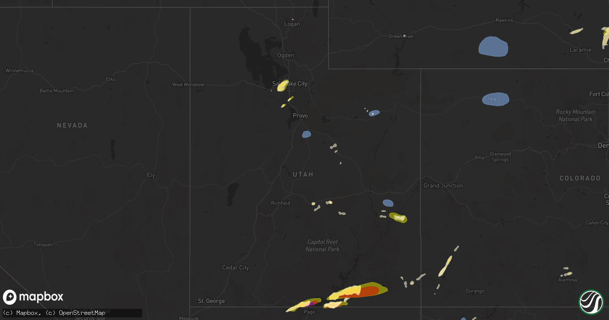
Hail Map in Utah on June 21, 2024
Get this storm
June 21 map
$229
one time, instant access
Download today. No call, no setup
Keep the $229
Bought the map and want the full workflow? Apply the entire $229 to a subscription within 7 days. None of it is wasted.
Every map, not just this one
This buys you this map. Subscription and you get every map we run, in the markets you choose from a few cities to whole states to nationwide. Plus real-time alerts the moment a storm fires.
Contact data
Name, contact info, occupancy, even credit band for addresses in the footprint. You go from where it hit to who to call.
Become the source they trust
Unlimited branding weather history reports on demand. You already have the documented answer ready for the property owner, and you are the one who showed up with it.
Property data and RoofTrace estimates
Pull up any address you have got, its value and the exact code rules for that jurisdiction, straight from One Click Code. Then RoofTrace estimates the squares, pitch, and roof value, priced the way you price.
Storm reports in Utah
Utah
| Date | Description |
|---|---|
| 06/21/20246:57 PM CDT | A local report indicates 1.00 inch wind near 3 SE Moab |
| 06/21/20246:52 PM CDT | Brief heavy rain. |
| 06/21/20246:27 PM CDT | Northwest wind direction. |
| 06/21/20245:12 PM CDT | Asos station kvel vernal rgnl airport. |
| 06/21/20244:35 PM CDT | Awos station k74v roosevelt airport. |
| 06/21/20243:50 PM CDT | Mesonet station uttp6 us-89 at pole creek bs. |
| 06/21/20242:50 PM CDT | Golf ball size hail reported at amangiri resort. |
| 06/21/20242:38 PM CDT | A local report indicates 1.00 inch wind near 2 W Draper |
| 06/21/20242:15 PM CDT | Social media photographs of hailstones ranging from approximately quarter to half dollar size in diameter. |
| 06/21/20242:00 PM CDT | Photo of quarter sized hail forwarded by broadcast media. |
| 06/21/20242:00 PM CDT | Follow-up public social media picture showing a hailstone near half dollar size in diameter. |
| 06/21/202410:50 AM CDT | A local report indicates 1.00 inch wind near 4 SW La Sal |
All States Impacted by Hail Map on June 21, 2024
Cities Impacted by Hail Map on June 21, 2024
- Rudyard, MT
- Egnar, CO
- Williamsfield, OH
- Orwell, OH
- Kinsman, OH
- Farmdale, OH
- Hobson, MT
- Geddes, SD
- Platte, SD
- Rosendale, NY
- Lake Andes, SD
- Armour, SD
- Stanford, MT
- Cedar Valley, UT
- Highland, NY
- Ulster Park, NY
- New Paltz, NY
- Eagle Mountain, UT
- Bosler, WY
- Magna, UT
- Kanab, UT
- Green River, WY
- Draper, UT
- Riverton, UT
- Glenrock, WY
- West Valley City, UT
- Salt Lake City, UT
- Sandy, UT
- Marble Canyon, AZ
- Douglas, WY
- Meeteetse, WY
- Moore, MT
- Cheyenne, WY
- West Greenwich, RI
- Houston, MN
- White Sulphur Springs, MT
- Neihart, MT
- Moosup, CT
- Shawnee, WY
- Thermopolis, WY
- Buffalo, WY
- Northfield, MA
- Vernon, VT
- Lewistown, MT
- Helper, UT
- Price, UT
- Sterling, CT
- Windsor, WI
- Deforest, WI
- Waunakee, WI
- Chambers, AZ
- Alamosa, CO
- Wingdale, NY
- Pawling, NY
- Dover Plains, NY
- Page, AZ
- Monument Valley, UT
- Tohatchi, NM
- Plainfield, CT
- Shiprock, NM
- Mosca, CO
- Sun Prairie, WI
- Madison, WI
- Readstown, WI
- Viroqua, WI
- Chugwater, WY
- Salina, UT
- Lake Powell, UT
- Ganado, AZ
- Stapleton, NE
- Winchester, NH
- Hinsdale, NH
- Farmington, NM
- Sanborn, IA
- Marshall, WI
- Waterloo, WI
- Lander, WY
- Bainbridge, NY
- Mount Upton, NY
- Hartley, IA
- Melvin, IA
- Duchesne, UT
- Sahuarita, AZ
- Lake Mills, WI
- Bluebell, UT
- Altamont, UT
- Wells Bridge, NY
- Unadilla, NY
- Roosevelt, UT
- Huntington, UT
- Bloomfield, NM
- Grover, CO
- Hereford, CO
- Everly, IA
- Mexican Hat, UT
- Tucson, AZ
- Brady, MT
- Conrad, MT
- Gallup, NM
- Ferron, UT
- Towaoc, CO
- Nunn, CO
- Grants, NM
- Riverton, WY
- Cortez, CO
- Otego, NY
- Watertown, WI
- Johnson Creek, WI
- Choteau, MT
- Big Sandy, MT
- Dutton, MT
- Ashford, CT
- Stafford Springs, CT
- North Platte, NE
- Spanish Fork, UT
- Fairview, UT
- Santaquin, UT
- Aztec, NM
- Flora Vista, NM
- Jay Em, WY
- Green River, UT
- Lewis, CO
- Carpenter, WY
- Box Elder, MT
- Spencer, IA
- Milford, IA
- Myton, UT
- Blanding, UT
- Pleasant View, CO
- Dolores, CO
- Cahone, CO
- Torrington, WY
- Vernal, UT
- Dickens, IA
- Ruthven, IA
- Eastford, CT
- Harwinton, CT
- Burlington, CT
- Carter, MT
- Salem, SD
- Canova, SD
- Floweree, MT
- New Raymer, CO
- Monticello, UT
- Winfred, SD
- Terril, IA
- Power, MT
- Norwood, CO
- Lloyd, MT
- Hooper, CO
- Emmetsburg, IA
- Madison, SD
- Montrose, SD
- Fairfield, MT
- Gregory, SD
- Dove Creek, CO
- Colton, SD
- Fort Benton, MT
- Hyde Park, UT
- Thompson, UT
- Moab, UT
- Great Falls, MT
- Highwood, MT
- Mitchell, SD
- Mount Vernon, SD
- Cubero, NM
- Letcher, SD
- Logan, UT
- Dell Rapids, SD
- Garrett, WY
- Utica, SD
- Harrison, SD
- Corsica, SD
- Belt, MT
- Browning, MT
- Pueblo Of Acoma, NM
- Pipestone, MN
- New Holland, SD
- Garretson, SD
- Plankinton, SD
- Geyser, MT
- Geraldine, MT
- Cozad, NE
- Hays, MT
- Wellfleet, NE
- Hayes Center, NE
- Wallace, NE
- Dickens, NE
- Volin, SD
- Alexandria, SD
- Lexington, NE
- Encampment, WY
- Rawlins, WY
- Saratoga, WY
- Gillette, WY
- Denton, MT
- Hilger, MT
- Raynesford, MT
- Palmer, NE
- Sumner, NE
- Miller, NE
- Sheridan, WY
- Dallas, PA
- Craig, CO
- Hayden, CO
- Hamilton, CO
- Steamboat Springs, CO
- Emery, SD
- Central City, NE
- Fullerton, NE
- New Haven, MI
- Columbus, MI
- Goodells, MI
- Buffalo, MT
- Amherst, NE
- Harris, IA
- Lake Park, IA
- Clarks, NE
- Osceola, NE
- Silver Creek, NE
- Spirit Lake, IA
- Payson, AZ
- Garryowen, MT
- Moccasin, MT
- Lodge Grass, MT
- Judith Gap, MT
- Tooele, UT
- Bridgeport, NE
- Bayard, NE
- Winnett, MT
- Ryegate, MT
- Lavina, MT
- Musselshell, MT
- Roundup, MT
- Ingomar, MT
- Broadwater, NE
- Sand Springs, MT
- Lisco, NE
- West Jordan, UT
- Forsyth, MT
- Oshkosh, NE
- Cohagen, MT
- Sedgwick, CO
- Chappell, NE
- Lewellen, NE
- Rosebud, MT
- Hathaway, MT
- Volborg, MT
- Maxwell, NE
- Brady, NE
- Gothenburg, NE
- Callaway, NE
- Ekalaka, MT
- Buffalo, SD


