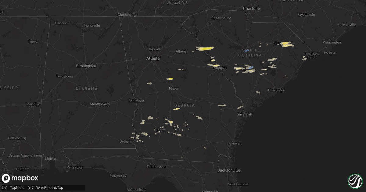
Hail Map in Georgia on June 20, 2019
Get this storm
June 20 map
$229
one time, instant access
Download today. No call, no setup
Keep the $229
Bought the map and want the full workflow? Apply the entire $229 to a subscription within 7 days. None of it is wasted.
Every map, not just this one
This buys you this map. Subscription and you get every map we run, in the markets you choose from a few cities to whole states to nationwide. Plus real-time alerts the moment a storm fires.
Contact data
Name, contact info, occupancy, even credit band for addresses in the footprint. You go from where it hit to who to call.
Become the source they trust
Unlimited branding weather history reports on demand. You already have the documented answer ready for the property owner, and you are the one who showed up with it.
Property data and RoofTrace estimates
Pull up any address you have got, its value and the exact code rules for that jurisdiction, straight from One Click Code. Then RoofTrace estimates the squares, pitch, and roof value, priced the way you price.
Storm reports in Georgia
Georgia
| Date | Description |
|---|---|
| 06/20/20196:58 PM CDT | A few trees down near highway 125 just northwest of nashville... Ga. |
| 06/20/20196:44 PM CDT | Bulloch 911 reported a tree down on deloach church rd at nevills groveland rd. |
| 06/20/20196:40 PM CDT | Multiple trees and power lines reported down throughout the northern portions of ware county. |
| 06/20/20196:40 PM CDT | Reports of countywide trees and powerlines down across pierce county. |
| 06/20/20196:39 PM CDT | Bulloch 911 reported a tree down on golf club dr at us301s. |
| 06/20/20196:35 PM CDT | Reports of trees and power lines down throughout appling county... With reports of trees having fallen on vehicles... But no structural damage has been observed. |
| 06/20/20196:30 PM CDT | Bulloch 911 reported a tree down near the intersection of ga169 and ga129. |
| 06/20/20196:20 PM CDT | Tree down near 200 camp ground church rd in coffee county. |
| 06/20/20196:20 PM CDT | Tree down near stagecoach road. |
| 06/20/20196:10 PM CDT | Trees and powerlines reported down in willacoochee area. |
| 06/20/20196:10 PM CDT | Tree across the line on tyty whiddon mill road. |
| 06/20/20196:08 PM CDT | Multiple power lines down in atkinson county... With 2 trees reported down near willacochee. |
| 06/20/20196:00 PM CDT | Several trees reported down in the area by 911 center. |
| 06/20/20195:55 PM CDT | Tree down on mcgirt st in poulan. |
| 06/20/20195:55 PM CDT | Tree was reported down in broxton. Time estimated from radar. |
| 06/20/20195:45 PM CDT | Bulloch 911 reported a power line down on randy lowery rd. |
| 06/20/20195:33 PM CDT | Tree down between ocilla and tifton... Ga near highway 319. |
| 06/20/20195:30 PM CDT | Part of a tree blocking half of the south bound lane on highway 82 west. |
| 06/20/20195:30 PM CDT | Tree down on dirt end of bussell pond off of pinetta. |
| 06/20/20195:30 PM CDT | Several trees down in early county. |
| 06/20/20195:30 PM CDT | Tree down on highway 107 between lands crossing and prospect church rd. |
| 06/20/20195:25 PM CDT | Tree down at isabella terrell rd close to worth turner rd. |
| 06/20/20195:23 PM CDT | Tree down on cannon road. |
| 06/20/20195:20 PM CDT | 2 trees down near bluffton road. |
| 06/20/20195:17 PM CDT | Tree down on brannens bridge road. |
| 06/20/20195:15 PM CDT | Screven 911 reported a tree down on a power line and partially blocking the road on n main st in sylvania. |
| 06/20/20195:15 PM CDT | Tree down on highway 313 at medders. |
| 06/20/20195:12 PM CDT | Tree down on ga hwy 17s near county line. |
| 06/20/20195:10 PM CDT | Tree down on bay branch road. |
| 06/20/20195:08 PM CDT | Tree blown down in the town of rhine. |
| 06/20/20195:04 PM CDT | Tree reported down on jaybird springs rd near jaybird springs. |
| 06/20/20194:53 PM CDT | Tree down on us hwy 25 n. |
| 06/20/20194:45 PM CDT | Tree down on ga 17 n. |
| 06/20/20194:30 PM CDT | 2-3 trees down on ga hwy 27 at mile marker 7... Ne of intersection with snow rd. |
| 06/20/20194:23 PM CDT | Trees down on 300 to 700 block of scenic route near lake blackshear |
| 06/20/20193:58 PM CDT | Tree and power lines reported down at the 1400 block of willow lake rd. |
| 06/20/20193:55 PM CDT | Trees down along benevolence highway. |
| 06/20/20193:51 PM CDT | Tree down on powerline on ga hwy 39... Just west of the intersection of hwy 27 |
| 06/20/20193:51 PM CDT | Tree down on ga hwy 27 at mm 10 near the intersection of canyon rd. |
| 06/20/20193:43 PM CDT | Trees down at highway 82 and moore station road. |
| 06/20/20193:40 PM CDT | At least 1 tree down at intersection of ga hwy 49 and forest hill rd sw. |
| 06/20/20193:39 PM CDT | Over a dozen trees reported down throughout the southern portion of balwin county... Mostly centered around scottsboro but including areas of hardwick/allenwood |
| 06/20/20193:35 PM CDT | The asos at thomson-mcduffie county airport recorded a wind gust of 69 mph. |
| 06/20/20193:20 PM CDT | A tree was reported down on sr 18 east and west at camelot road. |
| 06/20/20193:14 PM CDT | Gdot reports 2 trees down on i-75 sb blocking all lanes at exit 172 at bass rd |
| 06/20/20193:12 PM CDT | A tree was reported down on sr 87 north and south at christian road. |
| 06/20/20193:08 PM CDT | A tree was reported down on interstate 475 at sr 19/us 41/dixie highway. |
| 06/20/20193:08 PM CDT | 2 trees reported down... One on christmas ln and another on stallings rd |
| 06/20/20192:56 PM CDT | Total of 50-100 trees down beginning at 42 south and maynards mill rd... Continuing east. |
| 06/20/20192:35 PM CDT | Tree down at intersection of delray rd and rocky bottom rd. |
| 06/20/20192:35 PM CDT | Utility company reported a tree down on indian rd... Also knocking down power lines in lincoln county. Time estimated by radar. |
| 06/20/20192:32 PM CDT | Six pecan trees were reported down and caused damage to a barn and barn equipment in addition to two camper vehicles. |
| 06/20/20192:23 PM CDT | Reported trees down along gills point road near lake thurmond. |
| 06/20/20192:18 PM CDT | Two trees down on lawrence mill rd near kelly rd |
| 06/20/20192:18 PM CDT | Tree blown down on power lines on hwy 85 near greenville flat shoals rd |
| 06/20/20192:15 PM CDT | 911 call center reported a large area of about 40 trees down on wahatchee creek rd. |
| 06/20/20192:11 PM CDT | Law enforcement reported a power outage due to wind from a severe thunderstorm on shoreline drive in lincoln county. Time estimated by radar. |
| 06/20/20192:10 PM CDT | At least 4 trees down at render garrett rd and ga hwy 100. |
| 06/20/20192:05 PM CDT | Reports of numerous trees down near greenville including damage around the town square. |
| 06/20/20192:00 PM CDT | 911 call center reported trees down on bakers ferry rd & edison rd. |
| 06/20/20192:00 PM CDT | 911 call center reported trees down on washington hwy. |
| 06/20/20192:00 PM CDT | 911 call center reported trees down on mineral springs rd & fleming road ext. |
| 06/20/20191:42 PM CDT | 1-2 trees down near us78 and yancy rd. |
| 06/20/20191:41 PM CDT | Multiple trees and power lines were reported down on athens road... Smokey ridge road and wolfskin road. |
| 06/20/20191:25 PM CDT | 1-2 trees down near us78 and yancy rd. |
| 06/20/201912:55 PM CDT | Several trees down on the north side of of county farm rd bewteen hwt 82 n and i w davis rd |
| 06/20/20193:49 AM CDT | At 848 PM EDT, a severe thunderstorm was located near Argyle, moving southeast at 45 mph. HAZARD...60 mph wind gusts. SOURCE...Radar indicated. IMPACT...Expect damage to roofs, siding, and trees. Locations impacted include... Argyle, Stephen Foster State Park, Race Pond and Manor. |
| 06/20/20193:07 AM CDT | At 807 PM EDT, a severe thunderstorm was located near Blackshear, moving southeast at 35 mph. HAZARD...60 mph wind gusts. SOURCE...Radar indicated. IMPACT...Expect damage to roofs, siding, and trees. Locations impacted include... Waycross, Blackshear, Nahunta, Patterson, Offerman, Hickox, Boggy Bay, Raybon, Race Pond and Waynesville. |
| 06/20/20192:40 AM CDT | At 740 PM EDT, severe thunderstorms were located along a line extending from Pelham to near Alapaha, moving southeast at 35 mph. HAZARD...60 mph wind gusts. SOURCE...Radar indicated. In addition, trees have been reported down with these storms. IMPACT...Expect damage to roofs, siding, and trees. Locations impacted include... Nashville, Moultrie, Adel, Valdosta, Lakeland, Pelham, Camilla, Hahira, Sparks, Ray City, Norman Park, Lenox, Ochlocknee, Pavo, Coolidge, Moody Air Force Base, Riverside, Schley, Meigs and Morven. |
| 06/20/20192:39 AM CDT | At 739 PM EDT, severe thunderstorms were located along a line extending from Surrency to 10 miles north of Du Pont, moving southeast at 45 mph. HAZARD...60 mph wind gusts. SOURCE...Radar indicated. IMPACT...Expect damage to roofs, siding, and trees. Locations impacted include... Waycross, Jesup, Blackshear, Homerville, Patterson, Argyle, Surrency, Gardi, Screven and Odum. |
| 06/20/20191:49 AM CDT | At 649 PM EDT, severe thunderstorms were located along a line extending from Alston to 6 miles south of Enigma, moving southeast at 45 mph. HAZARD...60 mph wind gusts. SOURCE...Radar indicated. IMPACT...Expect damage to roofs, siding, and trees. Locations impacted include... Douglas, Baxley, Hazlehurst, Alma, Homerville, Pearson, Willacoochee, Broxton, Ambrose and Graham. |
| 06/20/20191:24 AM CDT | At 624 AM EDT, a severe thunderstorm was located over Funkhouser, or 14 miles southeast of Calhoun, moving east at 50 mph. HAZARD...60 mph wind gusts. SOURCE...Radar indicated. IMPACT...Expect damage to roofs, siding, and trees. Locations impacted include... Jasper, White, Waleska, Talking Rock, Fairmount, Salacoa Valley, Pine Log, Blaine, Talmadge, Folsom, Funkhouser and Hinton. |
| 06/20/20191:20 AM CDT | At 619 PM EDT, severe thunderstorms were located along a line extending from 8 miles northeast of Fitzgerald to 6 miles east of Marine Corps Logistics Base, moving east at 35 mph. HAZARD...60 mph wind gusts. SOURCE...Radar indicated. IMPACT...Expect damage to roofs, siding, and trees. Locations impacted include... Tifton, Nashville, Ocilla, Fitzgerald, Sylvester, Moultrie, Ashburn, Adel, Sparks, Enigma, Omega, Norman Park, Lenox, Poulan, Doerun, Ty Ty, Alapaha, Phillipsburg, Mystic and Unionville. |
| 06/20/20191:17 AM CDT | At 616 PM EDT, a severe thunderstorm was located near Alamo, moving east at 45 mph. HAZARD...60 mph wind gusts. SOURCE...Radar indicated. IMPACT...Expect damage to roofs, siding, and trees. Locations impacted include... McRae, Lyons, Soperton, Alamo, Mount Vernon, Vidalia, Helena, Lumber City, Glenwood, Uvalda, Stillmore, Oak Park, Ailey, Scotland, Higgston, Santa Claus, Alston, Jacksonville, Tarrytown and Towns. |
| 06/20/20191:06 AM CDT | At 606 PM EDT, severe thunderstorms were located along a line extending from 6 miles northeast of Barnwell to near Plant Vogtle, moving east at 70 mph. HAZARD...60 mph wind gusts. SOURCE...Radar indicated. IMPACT...Expect damage to trees and powerlines. Locations impacted include... Allendale, Fairfax, Sycamore, Ulmer, Seigling, Millett, Martin and Barton. |
| 06/20/20191:02 AM CDT | At 602 PM EDT, severe thunderstorms were located along a line extending from near Helena to near Sylvester, moving southeast at 40 mph. HAZARD...60 mph wind gusts. SOURCE...Radar indicated. IMPACT...Expect damage to roofs, siding, and trees. Locations impacted include... Douglas, Hazlehurst, Pearson, Willacoochee, Broxton, Ambrose, Nicholls, Pridgen, West Green and Snipesville. |
| 06/20/20191:01 AM CDT | At 601 AM EDT, a severe thunderstorm was located near Rome, moving east at 55 mph. HAZARD...60 mph wind gusts. SOURCE...Radar indicated. IMPACT...Expect damage to roofs, siding, and trees. Locations impacted include... Rome, Cartersville, Adairsville, White, Kingston, Cassville, Shannon, Pine Log and Folsom. |
| 06/20/201912:57 AM CDT | At 555 AM EDT/455 AM CDT/, severe thunderstorms were located along a line extending from 10 miles west of Pikeville to 6 miles north of Whitwell to near Signal Mountain to near La Fayette, moving northeast at 50 mph. HAZARD...70 mph wind gusts. SOURCE...Law enforcement. IMPACT...Expect considerable tree damage. Damage is likely to mobile homes, roofs, and outbuildings. Locations impacted include... Chattanooga, Cleveland, Dayton, Dunlap, Pikeville, Decatur, Soddy-Daisy, Signal Mountain, Rossville, Walden, Lakesite, Whitwell, Charleston, Ridgeside, Harrison, East Cleveland, South Cleveland, Fairmount, Wildwood Lake and Red Bank. |
| 06/20/201912:49 AM CDT | At 549 PM EDT, a severe thunderstorm was located over Seville, or 8 miles east of Cordele, moving east at 55 mph. HAZARD...60 mph wind gusts and quarter size hail. SOURCE...Radar indicated. IMPACT...Hail damage to vehicles is expected. Expect wind damage to roofs, siding, and trees. Locations impacted include... Cordele, Eastman, Abbeville, Rochelle, Milan, Arabi, Pineview, Rhine, Chauncey, Pitts, Jacksonville, Union, Seville, Ocmulgee Banks, Finleyson, Jay Bird Springs, China Hill, Pleasant View, Tippettville and Double Run. |
| 06/20/201912:48 AM CDT | At 547 PM EDT, a severe thunderstorm was located near Mayday, or 8 miles northwest of Statenville, moving east at 40 mph. HAZARD...60 mph wind gusts. SOURCE...Radar indicated. IMPACT...Expect damage to roofs, siding, and trees. Locations impacted include... Statenville, Du Pont and Mayday. |
| 06/20/201912:45 AM CDT | At 545 PM EDT, severe thunderstorms were located along a line extending from Pitts to near Leslie, moving east at 40 mph. HAZARD...60 mph wind gusts and penny size hail. SOURCE...Radar indicated. IMPACT...Expect damage to roofs, siding, and trees. Locations impacted include... Fitzgerald, Sylvester, Ashburn, Ocilla, Poulan, Ty Ty, Mystic, Worth, Terrell, Sycamore, Sumner, Warwick, Rebecca, Chokee, Amboy, Osierfield, Sylvester Airport, Tempy, Harding and Waterloo. |
| 06/20/201912:39 AM CDT | At 539 PM EDT, severe thunderstorms were located along a line extending from Three Points to Kite, moving east at 55 mph. HAZARD...60 mph wind gusts and quarter size hail. SOURCE...Radar indicated. IMPACT...Hail damage to vehicles is expected. Expect wind damage to roofs, siding, and trees. Locations impacted include... Garfield, Summertown, Three Points, Dellwood, Modoc, Canoochee and Blundale. |
| 06/20/201912:31 AM CDT | At 531 PM EDT, severe thunderstorms were located along a line extending from 9 miles northwest of Millen to 10 miles northwest of Swainsboro, moving east at 45 mph. HAZARD...60 mph wind gusts and penny size hail. SOURCE...Radar indicated. IMPACT...Expect damage to trees and powerlines. Locations impacted include... Statesboro, Metter, Millen, Sylvania, Middleground, Westside, Butts and Portal. |
| 06/20/201912:30 AM CDT | At 530 PM EDT, a severe thunderstorm was located over Hartford, or over Hawkinsville, moving east at 45 mph. HAZARD...60 mph wind gusts and quarter size hail. SOURCE...Radar indicated. IMPACT...Hail damage to vehicles is expected. Expect wind damage to roofs, siding, and trees. Locations impacted include... Dublin, Cochran, Eastman, Hawkinsville, Chester, Dexter, Dudley, Cadwell, Rentz, Dubois, Browndale, Plainfield, Empire, Cedar Grove, Mobley Crossing, Mock Springs, Roddy, Baileys Park, Rowland and Harlow. |
| 06/20/201912:28 AM CDT | At 528 PM EDT, a severe thunderstorm was located 7 miles west of Lake Park, moving northeast at 30 mph. HAZARD...60 mph wind gusts. SOURCE...Radar indicated. IMPACT...Expect damage to roofs, siding, and trees. Locations impacted include... Lake Park, Valdosta, I-75 At Exit 16, Moody Air Force Base, Remerton, Dasher, Naylor, Greenwood, Twin Lakes, Valdosta Regional Airport, Kinderlou, I-75 At Exit 5, Clyattville, I-75 At Exit 11 and Stockton. |
| 06/20/201912:25 AM CDT | At 525 PM EDT, a severe thunderstorm was located over Croxton Crossroads, or 10 miles southwest of Americus, moving east at 45 mph. HAZARD...60 mph wind gusts and quarter size hail. SOURCE...Radar indicated. IMPACT...Hail damage to vehicles is expected. Expect wind damage to roofs, siding, and trees. Locations impacted include... Americus, Plains, Byromville, Lilly, Dooling, Sumter, Lamar, Croxton Crossroads, New Era, Flint River Wma, Huntington, Pennington, Drayton, Maddox and Methvins. |
| 06/20/201912:21 AM CDT | At 520 PM EDT, a severe thunderstorm was located over Cobb, or 11 miles west of Cordele, moving east at 35 mph. HAZARD...60 mph wind gusts and quarter size hail. SOURCE...Radar indicated. IMPACT...Hail damage to vehicles is expected. Expect wind damage to roofs, siding, and trees. Locations impacted include... Cordele, Vienna, Arabi, Leslie, De Soto, Desoto, Cobb, East Crisp, Fort Early, Georgia Veterans Memorial St Pk, Richwood, Hatley, Tippettville, Raines, Tremont and Wenona. |
| 06/20/201912:17 AM CDT | At 517 PM EDT, a severe thunderstorm was located near Riddleville, or 11 miles east of Sandersville, moving east at 50 mph. HAZARD...60 mph wind gusts and quarter size hail. SOURCE...Radar indicated. IMPACT...Hail damage to vehicles is expected. Expect wind damage to roofs, siding, and trees. Locations impacted include... Louisville, Wadley, Bartow, Summertown, Three Points, Moxley, Blundale and Colemans Lake. |
| 06/19/201911:57 PM CDT | At 457 PM EDT, a severe thunderstorm was located near Hebron, or 9 miles northeast of Irwinton, moving east at 30 mph. HAZARD...60 mph wind gusts and penny size hail. SOURCE...Radar indicated. IMPACT...Expect damage to roofs, siding, and trees. Locations impacted include... Sandersville, Wrightsville, Irwinton, Davisboro, Tennille, McIntyre, Harrison, Toomsboro, Oconee, Deepstep, Riddleville, Downs, Beulah, Donovan, Warthen, Underwood, Linton, Grange, Pringle and Hebron. |
| 06/19/201911:55 PM CDT | At 455 PM EDT, a severe thunderstorm was located near Shellman, or near Cuthbert, moving east at 45 mph. HAZARD...60 mph wind gusts and quarter size hail. SOURCE...Radar indicated. IMPACT...Hail damage to vehicles is expected. Expect wind damage to roofs, siding, and trees. Locations impacted include... Dawson, Leesburg, Shellman, Smithville, Sasser, Bronwood, Parrott, Pachitla, Bridges Crossroad, Jordan Place, Yeomans, Dawson Municipal A/P, Graves, Oakville, Chambliss, Olivers Mill, Brooksville, Benevolence and Wades. |
| 06/19/201911:35 PM CDT | At 435 PM EDT, a severe thunderstorm was located 7 miles west of Cuthbert, moving east at 50 mph. HAZARD...60 mph wind gusts and penny size hail. SOURCE...Radar indicated. IMPACT...Expect damage to roofs, siding, and trees. Locations impacted include... Cuthbert, Shellman, Parrott, Springvale Station, Pachitla, Peterson Hill, Coles, White House, Graves, Chambliss, Morris, Brooksville, Benevolence, Springvale, Cotton Hill and Wades. |
| 06/19/201911:17 PM CDT | At 417 PM EDT, a severe thunderstorm was located over Springfield, or 8 miles north of Sparta, moving east at 45 mph. HAZARD...60 mph wind gusts and nickel size hail. SOURCE...Radar indicated. IMPACT...Expect damage to roofs, siding, and trees. Locations impacted include... Warrenton, Stapleton, Norwood, Camak, Springfield, Jewell, Beall Springs, Mayfield, Powelton, Reese, Mesena, Bastonville, Culverton and Barnett. |
| 06/19/201911:14 PM CDT | At 414 PM EDT, a severe thunderstorm was located near Arkwright, or 8 miles southwest of Gray, moving east at 55 mph. HAZARD...70 mph wind gusts and penny size hail. SOURCE...Radar indicated. IMPACT...Expect considerable tree damage. Damage is likely to mobile homes, roofs, and outbuildings. Locations impacted include... Macon, Milledgeville, Gray, Irwinton, Gordon, Ivey, McIntyre, Payne, Payne City, Midway-Hardwick, Postell, Bradley, Wayside, Allenwood, Mountain Springs, Griswoldville, Round Oak, Wesleyan, Arkwright and Hardwick. |
| 06/19/201911:09 PM CDT | At 409 AM CDT, severe thunderstorms were located along a line extending from near Crossville to near Ballplay to near Glencoe, moving northeast at 55 mph. HAZARD...60 mph wind gusts and penny size hail. SOURCE...Radar indicated. IMPACT...Expect damage to roofs, siding, and trees. Locations impacted include... Centre, Cedar Bluff, Little River Canyon National Preserve, Forney, Centre Municipal Airport, Leesburg, Sand Rock, Gaylesville, Tennala, Cherokee Rock Village, Cornwall Furnace Park, Blanche, Eastern Weiss Lake, Little River Falls, Slackland, Western Weiss Lake, Moshat, Ball Flat, Coloma and Weiss Dam. |
| 06/19/201910:57 PM CDT | At 357 PM EDT, a severe thunderstorm was located over Cadley, or 10 miles northwest of Thomson, moving east at 30 mph. HAZARD...60 mph wind gusts and quarter size hail. SOURCE...Radar indicated. IMPACT...Hail damage to vehicles is expected. Expect wind damage to roofs, siding, and trees. Locations impacted include... Cadley. |
| 06/19/201910:44 PM CDT | At 344 PM EDT, a severe thunderstorm was located over The Rock, or near Barnesville, moving east at 50 mph. HAZARD...60 mph wind gusts and quarter size hail. SOURCE...Radar indicated. IMPACT...Hail damage to vehicles is expected. Expect wind damage to roofs, siding, and trees. Locations impacted include... Macon, Thomaston, Barnesville, Forsyth, Yatesville, Payne, Meansville, Aldora, Payne City, The Rock, Bolingbroke, Dames Ferry, Russellville, Brent, Jarrell Plantation, Wesleyan, Redbone, Arkwright, Collier and Piedmont. |
| 06/19/201910:39 PM CDT | At 338 PM EDT, a severe thunderstorm was located near Juliette, or 10 miles south of Monticello, moving east at 35 mph. HAZARD...60 mph wind gusts and half dollar size hail. SOURCE...Radar indicated. IMPACT...Hail damage to vehicles is expected. Expect wind damage to roofs, siding, and trees. Locations impacted include... Milledgeville, Meriwether, Ethridge, Bradley, Wayside, Berner, Haddock, Resseaus Crossroads, Round Oak, Plant Harlee Branch, Hillsboro, Browns Crossing, Juliette, Stanfordville and Blountsville. |
| 06/19/201910:33 PM CDT | At 332 PM EDT, a severe thunderstorm was located over Fayetteville, moving east at 40 mph. HAZARD...60 mph wind gusts and quarter size hail. SOURCE...Radar indicated. IMPACT...Hail damage to vehicles is expected. Expect wind damage to roofs, siding, and trees. Locations impacted include... McDonough, Fayetteville, Jonesboro, Stockbridge, Riverdale, Lovejoy, Lake Spivey, Blacksville, Bonanza, Jw Smith Reservoir, Flippen, Eagles Landing and Irondale. |
| 06/19/201910:23 PM CDT | At 321 PM EDT, a severe thunderstorm was located over Molena, or 10 miles east of Greenville, moving east at 45 mph. HAZARD...60 mph wind gusts and penny size hail. SOURCE...Radar indicated. This storm has a history of producing widespread wind damage. IMPACT...Expect damage to roofs, siding, and trees. Locations impacted include... Thomaston, Barnesville, Zebulon, Molena, Yatesville, Meansville, Culloden, Aldora, The Rock, Sunset Village, Atwater, Goggins, Lifsey Springs, Crest, Redbone, Hannahs Mill, Piedmont and Johnstonville. |
| 06/19/20199:48 PM CDT | At 248 PM EDT, a severe thunderstorm was located over Mountville, or 7 miles east of LaGrange, moving east at 35 mph. HAZARD...60 mph wind gusts and penny size hail. SOURCE...Radar indicated. IMPACT...Expect damage to roofs, siding, and trees. Locations impacted include... LaGrange, Greenville, Woodbury, Molena, Gay, Raleigh, Mountville, Louise, Odessadale, Stovall, Big Springs, Durand, Harris City and Imlac. |
| 06/19/20199:41 PM CDT | At 240 PM EDT, a severe thunderstorm was located over Vesta, or 9 miles northeast of Lexington, moving east at 45 mph. HAZARD...60 mph wind gusts and nickel size hail. SOURCE...Radar indicated. IMPACT...Expect damage to roofs, siding, and trees. Locations impacted include... Lexington, Crawford, Tignall, Arnoldsville, Carlton, Rayle, Athens-Clarke County, Jacksons Crossroads, Mallorysville, Delhi, Norman, Smithonia, Hutchings, Metasville, Floral Hill, Newtown, Danburg, Celeste, Watson Mill Bridge State Park and Vesta. |
| 06/19/20197:15 PM CDT | Multiple reports of trees and power lines down in wayne county... With 2-3 trees reported down near screven. |
| 06/19/20197:00 PM CDT | Several trees down in early county. |
All States Impacted by Hail Map on June 20, 2019
Cities Impacted by Hail Map on June 20, 2019
- Fort Morgan, CO
- Effingham, KS
- Lancaster, KS
- Sac City, IA
- Lake View, IA
- Wood Lake, NE
- Eustis, NE
- Harrison, NE
- Moorhead, IA
- Runnells, IA
- Prairie City, IA
- Hayes Center, NE
- Wallace, NE
- Blackville, SC
- Diller, NE
- Odell, NE
- Blakely, GA
- Endicott, NE
- Steele City, NE
- Fairbury, NE
- Pampa, TX
- Redwood Falls, MN
- Akron, CO
- Odebolt, IA
- Schaller, IA
- Early, IA
- Leavenworth, KS
- Bonner Springs, KS
- Platte City, MO
- Basehor, KS
- Waldron, MO
- Kansas City, MO
- Kansas City, KS
- Modoc, SC
- Lincolnton, GA
- Plum Branch, SC
- Funk, NE
- Bertrand, NE
- Loomis, NE
- Elm Creek, NE
- Overton, NE
- Holdrege, NE
- Hardy, NE
- Bellvue, CO
- Loveland, CO
- Pierce, CO
- Nunn, CO
- Fort Collins, CO
- McCook, NE
- Bloomington, NE
- Lenora, KS
- Randolph, KS
- Grand Island, NE
- Dannebrog, NE
- Saint Libory, NE
- Carpenter, WY
- Pine Bluffs, WY
- Grover, CO
- Eatonton, GA
- Madison, GA
- Fitzgerald, GA
- Dana, IA
- Jefferson, IA
- Grand Junction, IA
- Arabi, GA
- Ashburn, GA
- Merriman, NE
- Cody, NE
- Clarkfield, MN
- Granite Falls, MN
- Cope, CO
- Padroni, CO
- Merino, CO
- Stoneham, CO
- Sterling, CO
- New Raymer, CO
- Shenandoah, IA
- Blue Earth, MN
- Strasburg, CO
- Harleyville, SC
- Holly Hill, SC
- Wood Lake, MN
- Echo, MN
- Boelus, NE
- Cairo, NE
- Burchard, NE
- Liberty, NE
- Hanover, KS
- Skidmore, MO
- Graham, MO
- Marion, SC
- Florence, SC
- Bennett, CO
- Onawa, IA
- Westboro, MO
- Northboro, IA
- Guyton, GA
- Rincon, GA
- Marsland, NE
- Dimock, SD
- Parkston, SD
- Mount Vernon, SD
- Ethan, SD
- Wilsonville, NE
- Hendley, NE
- Norton, KS
- Morgan, MN
- Springfield, MN
- Comfrey, MN
- Sleepy Eye, MN
- Truman, MN
- Saint James, MN
- Lewisville, MN
- Hanska, MN
- Clements, MN
- Madelia, MN
- Yuma, CO
- Idalia, CO
- Anton, CO
- Joes, CO
- Wray, CO
- Saint Francis, KS
- Kirk, CO
- Vernon, CO
- Imperial, NE
- Vermillion, KS
- Briggsdale, CO
- Republic, KS
- Byron, NE
- Superior, NE
- Webber, KS
- Abbeville, SC
- Bradley, SC
- McCormick, SC
- Calhoun Falls, SC
- Tignall, GA
- Elberton, GA
- Troy, SC
- Mount Carmel, SC
- Salley, SC
- Tifton, GA
- Red Cloud, NE
- Bladen, NE
- Inavale, NE
- Durham, NC
- Whitney, NE
- Crawford, NE
- Monticello, GA
- Juliette, GA
- Melrose, IA
- Albia, IA
- Denver, CO
- Aurora, CO
- Evans, GA
- Augusta, GA
- Page, NE
- Brunswick, NE
- Orchard, NE
- Royal, NE
- Winnetoon, NE
- Benkelman, NE
- Parks, NE
- Sycamore, GA
- Afton, TN
- Limestone, TN
- Chuckey, TN
- Stratton, NE
- Palisade, NE
- Trenton, NE
- Belview, MN
- Creedmoor, NC
- Knoxville, TN
- Greeleyville, SC
- Corsicana, TX
- Perry, IA
- Ogden, IA
- Dixon, NE
- Seneca, KS
- Sabetha, KS
- Oneida, KS
- Nelson, NE
- Saint George, KS
- Wamego, KS
- Scottsbluff, NE
- Alliance, NE
- Woodrow, CO
- Centralia, KS
- Craig, MO
- Fairfax, MO
- Colby, KS
- Karval, CO
- Lexington, NE
- Smithfield, NE
- Amherst, NE
- Kearney, NE
- Riverdale, NE
- Byers, CO
- Hanley Falls, MN
- Sloan, IA
- Hoxie, KS
- Selden, KS
- Stamford, NE
- Long Island, KS
- Deer Trail, CO
- Wetmore, KS
- Vona, CO
- Atchison, KS
- Nortonville, KS
- Arapahoe, NE
- Republican City, NE
- Winterset, IA
- Prole, IA
- Patterson, IA
- Saint Charles, IA
- Milford, NE
- Enigma, GA
- Saint Paul, NE
- Pamplico, SC
- Effingham, SC
- Ault, CO
- Bolivia, NC
- Cummings, KS
- Mankato, KS
- Glen Elder, KS
- Thomaston, GA
- Molena, GA
- Woodbury, GA
- Farnam, NE
- Lusk, WY
- Naponee, NE
- Delia, KS
- Mayetta, KS
- Bellevue, TX
- Appling, GA
- Clarks Hill, SC
- Oberlin, KS
- Herndon, KS
- Champion, NE
- Garrison, UT
- Washta, IA
- Quimby, IA
- Pawnee City, NE
- Axtell, KS
- Baileyville, KS
- Palmer, KS
- Aurora, KS
- Glasco, KS
- Clyde, KS
- Green, KS
- Concordia, KS
- Morganville, KS
- Miltonvale, KS
- Jamestown, KS
- Clay Center, KS
- Clifton, KS
- Leonardville, KS
- Scottsville, KY
- Cordova, SC
- Orangeburg, SC
- Neeses, SC
- Cope, SC
- Rushville, MO
- Correctionville, IA
- Seward, NE
- Chester, NE
- Hebron, NE
- Macon, NC
- Sellers, SC
- Mullins, SC
- Davenport, NE
- Oak, NE
- Fullerton, NE
- Palmer, NE
- Bishopville, SC
- Telford, TN
- Greeneville, TN
- Statesboro, GA
- Metter, GA
- Register, GA
- Ariton, AL
- Brundidge, AL
- Clio, AL
- Axtell, NE
- Minden, NE
- Blue Hill, NE
- Indianola, NE
- Friend, NE
- Cordova, NE
- Exeter, NE
- Formoso, KS
- Courtland, KS
- Jewell, KS
- Rembert, SC
- Preston, GA
- Parrott, GA
- Olsburg, KS
- Westmoreland, KS
- Haigler, NE
- Wauneta, NE
- Atwood, KS
- Shickley, NE
- Branchville, VA
- Boykins, VA
- Forsyth, GA
- Downs, KS
- Esbon, KS
- Chadron, NE
- Beaver City, NE
- Paton, IA
- Hubbell, NE
- Narka, KS
- Munden, KS
- Jennings, KS
- Churdan, IA
- Dearborn, MO
- Gower, MO
- Edgerton, MO
- Skipperville, AL
- Banks, AL
- Troy, AL
- Holbrook, NE
- Edison, NE
- Oxford, NE
- Cambridge, NE
- Rebecca, GA
- Chula, GA
- Barnes, KS
- Waterville, KS
- Blue Rapids, KS
- Onaga, KS
- Maitland, MO
- Maryville, MO
- Hawkinsville, GA
- Pineview, GA
- Unadilla, GA
- Streetman, TX
- Enders, NE
- Grovetown, GA
- North Augusta, SC
- Moorefield, NE
- Lebanon, NE
- Norcatur, KS
- Danbury, NE
- Vesta, MN
- Sanborn, MN
- Seaforth, MN
- Cottonwood, MN
- Lamberton, MN
- Winnebago, MN
- Milligan, NE
- Easton, MO
- Saint Joseph, MO
- Carlton, GA
- Repton, AL
- York, NE
- McCool Junction, NE
- Rexford, KS
- Burlington, CO
- Hemingford, NE
- Plattsburg, MO
- Mound City, MO
- Deshler, NE
- Alma, NE
- Littleton, NC
- Granada, MN
- Bushnell, NE
- Frankfort, KS
- Glendo, WY
- Columbia, NC
- Summerton, SC
- Pinewood, SC
- Stanberry, MO
- Creighton, NE
- Oneill, NE
- Auburn, IA
- Lindon, CO
- Oelrichs, SD
- Valentine, NE
- Ainsworth, NE
- Springview, NE
- Johnstown, NE
- Americus, GA
- Plains, GA
- Dawson, GA
- Kenesaw, NE
- Heartwell, NE
- Montgomery, AL
- Ramer, AL
- Forsyth, MT
- Orleans, NE
- Williston, SC
- Pickering, MO
- Burlington Junction, MO
- Sacred Heart, MN
- Tonganoxie, KS
- Glade, KS
- Phillipsburg, KS
- Mount Ayr, IA
- Valdosta, GA
- Arlington, GA
- Morgan, GA
- Torrington, WY
- Beloit, KS
- Manning, SC
- New Zion, SC
- Norway, SC
- Bird City, KS
- Hay Springs, NE
- Rushville, NE
- Kilgore, NE
- Crookston, NE
- Nenzel, NE
- Gordon, NE
- Ellsworth, NE
- Lakeside, NE
- Hoyt, KS
- Osceola, IA
- Haddam, KS
- Lyons, NE
- Rosalie, NE
- Eutawville, SC
- Crow Agency, MT
- Leary, GA
- Newton, GA
- Rowesville, SC
- Ravenna, NE
- Newville, AL
- Clopton, AL
- Branchville, SC
- Bowman, SC
- Home, KS
- Marysville, KS
- Smithville, GA
- Manhattan, KS
- Hillsborough, NC
- Springfield, SC
- Waco, NE
- Kirwin, KS
- Guide Rock, NE
- Saint Marys, KS
- Rossville, KS
- Elmore, MN
- Seibert, CO
- Logan, KS
- Abbeville, AL
- Shorterville, AL
- Eckley, CO
- Genoa, CO
- Rock Port, MO
- Ludell, KS
- Camden, SC
- Lebanon, KS
- Denmark, SC
- Bamberg, SC
- Galva, IA
- Ida Grove, IA
- Holstein, IA
- Falls City, NE
- Ocilla, GA
- Boone, IA
- Turney, MO
- Albany, GA
- Leesburg, GA
- Breda, IA
- Carroll, IA
- Bouton, IA
- Woodward, IA
- Caryville, TN
- Arcadia, IA
- Wood River, NE
- Netawaka, KS
- Whiting, KS
- Columbia, AL
- Whiting, IA
- Wymore, NE
- Worden, MT
- Watkins, CO
- McFall, MO
- Albany, MO
- Cuba, KS
- Agenda, KS
- Belleville, KS
- Everest, KS
- Randall, KS
- Norway, KS
- Scandia, KS
- Smithville, MO
- Trimble, MO
- Bartley, NE
- Elwood, NE
- De Kalb, MO
- Faucett, MO
- Agra, KS
- Glidden, IA
- Cuthbert, GA
- Farragut, IA
- Hamburg, IA
- Fairfield, TX
- Shelton, NE
- Rockville, NE
- Muscotah, KS
- Culbertson, NE
- Henderson, NE
- Hampton, NE
- Coin, IA
- Cross, SC
- Swan, IA
- Adel, IA
- Gaylord, KS
- Osborne, KS
- Flagler, CO
- Hazard, NE
- Tarkio, MO
- Guilford, MO
- Lawrence, NE
- Castalia, NC
- Louisburg, NC
- Maywood, NE
- Emmett, KS
- Curtis, NE
- Imogene, IA
- Emerson, NE
- Nehawka, NE
- Avoca, NE
- Jansen, NE
- Plymouth, NE
- Fort Leavenworth, KS
- Colquitt, GA
- Horton, KS
- Belgrade, NE
- Gibbon, NE
- Green Pond, SC
- Alton, KS
- Portis, KS
- Salem, NE
- Giltner, NE
- Aurora, NE
- Van Meter, IA
- Warwick, GA
- Amity, MO
- Commerce City, CO
- Maysville, MO
- Easton, KS
- Agency, MO
- Goff, KS
- Corning, KS
- Linn, KS
- Greenleaf, KS
- Pierson, IA
- Benedict, NE
- Weston, MO
- Edgar, NE
- Ong, NE
- Carleton, NE
- Ruskin, NE
- Sutton, NE
- Atlanta, NE
- Odessa, NE
- Pleasanton, NE
- Belvue, KS
- Groom, TX
- Rippey, IA
- Minburn, IA
- Lovilia, IA
- Moravia, IA
- Wellfleet, NE
- De Soto, IA
- De Soto, GA
- Cordele, GA
- Cobb, GA
- Oakfield, GA
- Myrtle Beach, SC
- Athens, TX
- Strang, NE
- McDonald, KS
- Hollenberg, KS
- Morrowville, KS
- Mahaska, KS
- Stromsburg, NE
- Polk, NE
- Conway, SC
- Asheboro, NC
- Fairmont, NE
- Lenox, IA
- Claxton, GA
- Poulan, GA
- Sylvester, GA
- Diagonal, IA
- Gresham, NE
- Sergeant Bluff, IA
- Sioux City, IA
- Salix, IA
- Bronson, IA
- Nashville, NC
- Waycross, GA
- Wathena, KS
- Elsie, NE
- Franklin, NE
- Riverton, NE
- Lohrville, IA
- Vance, SC
- Beaver, IA
- Moncure, NC
- Cozad, NE
- Lumber City, GA
- McRae Helena, GA
- Hazlehurst, GA
- Kimball, NE
- Bern, KS
- Dresden, KS
- Bogue, KS
- Plainview, NE
- Darlington, MO
- Jamestown, SC
- Lake City, IA
- Wall Lake, IA
- Iliff, CO
- Tyndall, SD
- Truro, IA
- Beaver Crossing, NE
- Dorchester, NE
- Bruning, NE
- Belvidere, NE
- Washington, KS
- Kingstree, SC
- Barnard, MO
- Bolckow, MO
- Warrenton, NC
- Albion, NE
- Reynolds, NE
- Pattonsburg, MO
- Graham, TX
- Olney, TX
- Bradshaw, NE
- Rosebud, MT
- Minneota, MN
- Wilcox, NE
- Clearmont, MO
- Forest City, MO
- Maxwell, NE
- Savannah, MO
- Amazonia, MO
- Andalusia, AL
- Madrid, IA
- Jefferson, SD
- Auburn, NE
- Otoe, NE
- Wray, GA
- Lathrop, MO
- Ty Ty, GA
- Verdigre, NE
- Cawker City, KS
- Hubbard, NE
- Waterbury, NE
- Dawson, IA
- Jamaica, IA
- Alcolu, SC
- Juniata, NE
- Laporte, CO
- Recluse, WY
- Weston, WY
- Gillette, WY
- Jonesborough, TN
- Columbia, SC
- Cayce, SC
- Kensington, KS
- Inland, NE
- Trumbull, NE
- Hildreth, NE
- Holstein, NE
- Athol, KS
- Harvard, NE
- Almena, KS
- Clay Center, NE
- Fairfield, NE
- Roseland, NE
- Alda, NE
- Prairie View, KS
- Ayr, NE
- Saronville, NE
- Campbell, NE
- Smith Center, KS
- Upland, NE
- Marquette, NE
- Deweese, NE
- Hastings, NE
- Doniphan, NE
- Central City, NE
- Chapman, NE
- Phillips, NE
- Glenvil, NE
- Blanch, NC
- Oxford, NC
- Ringgold, VA
- Alton, VA
- Providence, NC
- Roxboro, NC
- Milton, NC
- Pelham, NC
- Semora, NC
- Virgilina, VA
- Timberlake, NC
- Hurdle Mills, NC
- Mebane, NC
- Rougemont, NC
- Burlington, NC
- Prospect Hill, NC
- Yanceyville, NC
- Leasburg, NC
- New Ulm, MN
- Wanda, MN
- Darfur, MN
- Amboy, MN


