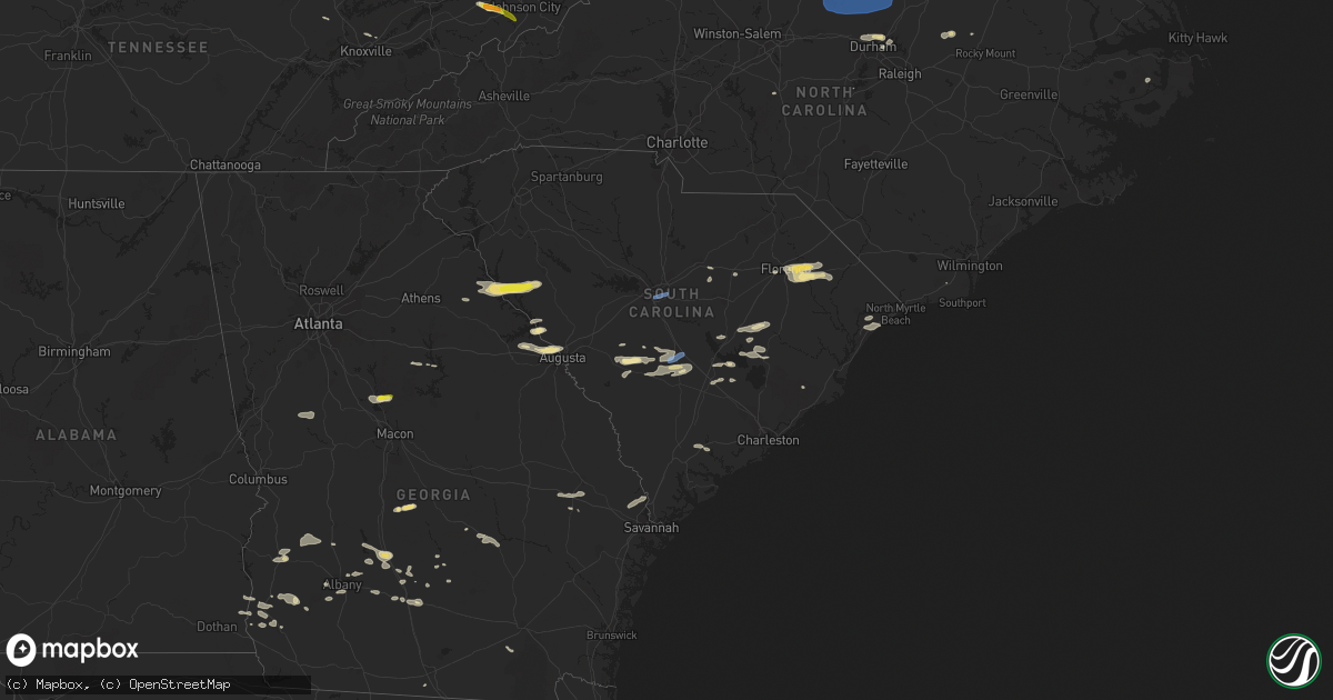
Hail Map in South Carolina on June 20, 2019
Get this storm
June 20 map
$229
one time, instant access
Download today. No call, no setup
Keep the $229
Bought the map and want the full workflow? Apply the entire $229 to a subscription within 7 days. None of it is wasted.
Every map, not just this one
This buys you this map. Subscription and you get every map we run, in the markets you choose from a few cities to whole states to nationwide. Plus real-time alerts the moment a storm fires.
Contact data
Name, contact info, occupancy, even credit band for addresses in the footprint. You go from where it hit to who to call.
Become the source they trust
Unlimited branding weather history reports on demand. You already have the documented answer ready for the property owner, and you are the one who showed up with it.
Property data and RoofTrace estimates
Pull up any address you have got, its value and the exact code rules for that jurisdiction, straight from One Click Code. Then RoofTrace estimates the squares, pitch, and roof value, priced the way you price.
Storm reports in South Carolina
South Carolina
| Date | Description |
|---|---|
| 06/20/20196:59 PM CDT | Charleston county dispatch reported a power line down on natty rd. |
| 06/20/20196:59 PM CDT | Charleston county dispatch reported a tree down on dixie plantation rd. |
| 06/20/20196:42 PM CDT | Trees blown down near the intersection of highway 61 and highway 165. Time estimated based on radar. |
| 06/20/20196:36 PM CDT | Schp reported a tree down on bees creek rd at ellis hodges rd. |
| 06/20/20196:30 PM CDT | Schp reported a tree down on bennetts point rd at mt olive rd. |
| 06/20/20196:30 PM CDT | A member of the public shared pictures on social media of a large tree that was uprooted and caused damage to a house. Time is estimated by radar. |
| 06/20/20196:28 PM CDT | Schp reported a tree down on rodeo dr at sc64. |
| 06/20/20196:28 PM CDT | Schp reported a tree down on charleston hwy. |
| 06/20/20196:25 PM CDT | Schp reported a tree down on bedon rd near us17a. |
| 06/20/20196:24 PM CDT | Schp reported a tree down on green pond hwy. |
| 06/20/20196:19 PM CDT | An emergency manager reported that a tree fell on a powerline on browntown lane. |
| 06/20/20196:19 PM CDT | Schp reported a tree down on ritter rd near us17a. |
| 06/20/20196:19 PM CDT | Schp reported a tree down on augusta hwy near the edisto river. |
| 06/20/20196:16 PM CDT | Schp reported a tree down on mewville rd at moore hill. |
| 06/20/20196:14 PM CDT | Schp reported a tree down on i-95 at mm53 and mm44. |
| 06/20/20196:14 PM CDT | Schp reported a tree down on black creek rd near cavanaugh rd. |
| 06/20/20196:10 PM CDT | Schp reported a tree down on rehoboth rd at augusta hwy. |
| 06/20/20196:06 PM CDT | Trees down... Blocking some roads... And power out. |
| 06/20/20196:05 PM CDT | Jasper county 911 reported a tree down on grays hwy at johnson rd. |
| 06/20/20195:55 PM CDT | Schp reported a tree down on garris hill loop. |
| 06/20/20195:45 PM CDT | Emergency manager relayed report of two large trees down on lawton avenue. |
| 06/20/20195:37 PM CDT | Warning point reported tree down on kearse road. |
| 06/20/20195:32 PM CDT | Allendale county warning point reported tree down on highway 3 heading toward estill. |
| 06/20/20195:15 PM CDT | Barnwell dispatch reported trees down on the road along patterson mill rd. Time estimated by radar. |
| 06/20/20195:15 PM CDT | Corrects previous tstm wnd dmg report from 1 nne manning for correct time. Clarendon county dispatch reported trees down on the road on cedar street. Time estimated by |
| 06/20/20195:12 PM CDT | Tree down on santee river rd near us-17a. |
| 06/20/20195:09 PM CDT | Wunderground station at cresent beach |
| 06/20/20195:05 PM CDT | Tree down on bethera rd. |
| 06/20/20195:03 PM CDT | Clarendon county dispatch reported a tree knocked down powerlines on liberty hill rd at oaks rd. Time estimated by radar. |
| 06/20/20195:00 PM CDT | Berkeley county 911 reported a tree down on hood st in st stephen. |
| 06/20/20194:54 PM CDT | Public report received of roof damage and awning torn off youngs market on cannon bridge road. Time estimated by radar. |
| 06/20/20194:53 PM CDT | Tree down on prosperity ln near sc hwy 45. |
| 06/20/20194:52 PM CDT | Barnwell dispatch reported trees down on the road at springfield rd and elko st. Time estimated by radar. |
| 06/20/20194:52 PM CDT | Skywarn spotter reported estimated 60 mph-plus winds. Tree damage observed with trees and limbs down... Trees down on on cars... And signs blown off billboards on and i |
| 06/20/20194:41 PM CDT | Berkeley county 911 reported a tree down on oakland club rd near sc hwy 45. |
| 06/20/20194:40 PM CDT | Berkeley county 911 reported a tree down on riverbank rd near pineville. |
| 06/20/20194:35 PM CDT | Clarendon county dispatch reported trees down on the road on cedar street. Time estimated by radar. |
| 06/20/20194:32 PM CDT | Schp reported a tree in roadway at sc4 and union academy rd in aiken county. Time estimated by radar. |
| 06/20/20194:30 PM CDT | Public reported several trees blown down and some shingles blown off roof of home. |
| 06/20/20194:27 PM CDT | Schp reported a tree in roadway at state park road and harness race ln in aiken county. Time estimated by radar. |
| 06/20/20194:25 PM CDT | Numerous trees down ascauga lake road near langley sc. |
| 06/20/20194:24 PM CDT | Schp reported a tree in roadway at richardson lake rd in aiken county. Time estimated by radar. |
| 06/20/20194:23 PM CDT | Schp reported a tree down in road way at 12 bridges road and us 521. Time estimated by radar. |
| 06/20/20194:22 PM CDT | Schp reported a tree down in road way at interstate 95 at 146 sb. Time estimated by radar. |
| 06/20/20194:22 PM CDT | Several big trees down near cashua st between 5 points and 2nd loop. |
| 06/20/20194:22 PM CDT | Trees and sign down on palmetto st in florence |
| 06/20/20194:19 PM CDT | Tree down on bradley bay road near cade road. |
| 06/20/20194:17 PM CDT | Tree down on power line on west broad st in darlington |
| 06/20/20194:17 PM CDT | Media reports tree down on sally hill rd in the timmonsville community |
| 06/20/20194:16 PM CDT | Broadcast media reported roof damage and awning ripped off building at breezy hill curb market gas station in aiken county. Time estimated by radar. |
| 06/20/20194:14 PM CDT | Tree down on county line road between new farm rd and pleasant hill drive. |
| 06/20/20194:14 PM CDT | Marion county airport |
| 06/20/20194:12 PM CDT | Schp reports tree in roadway celeste ave and charity lane. Time estimated by radar. |
| 06/20/20194:12 PM CDT | Schp reported multiple trees with power lines down on conger drive... Evans drive and ivy circle. Time estimated by radar. |
| 06/20/20194:11 PM CDT | Schp reported a tree down in road way at 3175 florence highway and goza road. Time estimated by radar. |
| 06/20/20194:10 PM CDT | Tree partially blocking road breezy hill road and old cherokee indian road. |
| 06/20/20194:10 PM CDT | Schp reported a tree down in road way at hazel street and elizabeth ave. Time estimated by radar. |
| 06/20/20194:09 PM CDT | Schp reported a tree in roadway at gregg st and a p nivens st in aiken county. Time estimated by radar. |
| 06/20/20194:07 PM CDT | Schp reported a tree down in road way at lewis road and kingsbury road... Sumter county. Time estimated by radar. |
| 06/20/20194:06 PM CDT | Schp reported tree in roadway homestead road and nassau drive. |
| 06/20/20194:04 PM CDT | Trees are down across oates highway in darlington county headed toward the bridge at i-20. Road may be impassable. |
| 06/20/20194:00 PM CDT | Schp reported a tree down in road way at oakdale ave and whatley road. Time estimated by radar. |
| 06/20/20194:00 PM CDT | Multiple trees reported down along ascauga lake and sleep hollow road. S. |
| 06/20/20193:57 PM CDT | Trees and powerlines down i-20 and highway 25. |
| 06/20/20193:57 PM CDT | Broadcast media reported trees and power lines down on whitehall rd and prince william dr in aiken county. Time estimated by radar. |
| 06/20/20193:57 PM CDT | Report of a tree down on house at ashley circle and whatley st in aiken county. Time estimated by radar. |
| 06/20/20193:54 PM CDT | Schp reports tree in roadway... I-20 at mile marker 1 eb. |
| 06/20/20193:52 PM CDT | Powerlines down at the intersection of francis marion road and u.s route 301/76. |
| 06/20/20193:52 PM CDT | Corrects previous tstm wnd dmg report from 7 nnw aiken. Schp reports power lines in roadway i-20 at highway 191. |
| 06/20/20193:50 PM CDT | A social media user reported a large tree down on sudlow lake rd and ascuaga lake rd... Knocking down power lines... In aiken county. Time estimated by radar. |
| 06/20/20193:50 PM CDT | Emergency management reported a power line down due to tree and arching. Time reported by radar. |
| 06/20/20193:48 PM CDT | Schp reports tree in roadway i-20 at mile marker 158 westbound. Time estimated by radar. |
| 06/20/20193:48 PM CDT | Schp reported a tree down on roadway at 3855 furman field rd and grant china ln. Time estimated by radar. |
| 06/20/20193:48 PM CDT | Schp reported a tree down in road way at tb wright road and camden highway. Time estimated by radar. |
| 06/20/20193:45 PM CDT | Schp reported tree in roadway on i-20... Mile marker 145. Time estimated by radar. |
| 06/20/20193:43 PM CDT | Emergency management reported tree blocking entrance to neighborhood. Time reported by radar. |
| 06/20/20193:41 PM CDT | Schp reported a tree down in road way at interstate 95 116 sb. Time estimated by radar 4:41 pm. |
| 06/20/20193:40 PM CDT | Large tree down on atlas road in front of bible way church. The road is impassable. Wis tv. |
| 06/20/20193:39 PM CDT | Tree down at ham road and us route 76. |
| 06/20/20193:39 PM CDT | Emergency management reported tree fell on power line near first street south. Time reported by radar. |
| 06/20/20193:38 PM CDT | Emergency management reported a tree fell on house and collapsed structure. Time reported by radar. |
| 06/20/20193:36 PM CDT | Emergency management reported tree fell on power line. Time reported by radar. |
| 06/20/20193:36 PM CDT | Schp reported tree in roadway hwy 301 at sc332. Time estimated by radar. |
| 06/20/20193:35 PM CDT | Schp reports tree in roadway on i-26 at mile marker 7. |
| 06/20/20193:35 PM CDT | Tree down - deveraux and adger road columba per wltx tv. |
| 06/20/20193:34 PM CDT | Emergency management reported power lines arching on south ravenel st. Time reported by radar. |
| 06/20/20193:34 PM CDT | Emergency management reported tree blocking roadway at glenwood road and manchester road. Time reported by radar. |
| 06/20/20193:33 PM CDT | Emergency management reported tree leaning on power line and arching. Time reported by radar. |
| 06/20/20193:33 PM CDT | Emergency management reported tree fell onto the corner of a house on clark street. Time estimated by radar. |
| 06/20/20193:32 PM CDT | Emergency management reported power lines arching on two notch road near midland shopping center. Time reported by radar. |
| 06/20/20193:32 PM CDT | Emergency management reported tree down across power lines near franklin and wallace street. Time estimated by radar. |
| 06/20/20193:31 PM CDT | Emergency management reported tree down blocking roadway near pendleton street. Time estimated by radar. |
| 06/20/20193:31 PM CDT | Emergency management reported tree fell onto power line/power line sparking on river drive. Time estimated by radar. |
| 06/20/20193:30 PM CDT | Several trees down. Some roof damage. |
| 06/20/20193:30 PM CDT | Social media reported a large tree limb down on a car at providence hospital in richland county. Time estimated by radar. |
| 06/20/20193:30 PM CDT | Emergency management reported multiple trees down in roadway near assembly street and richland street. Time estimated by radar. |
| 06/20/20193:30 PM CDT | William brice stadium mesonet site. |
| 06/20/20193:29 PM CDT | Emergency management reported tree fell on power line and arching. Time reported by radar. |
| 06/20/20193:29 PM CDT | A social media user reported a tree uprooted at bull and gervais st in downtown columbia in richland county. Time estimated by radar. |
| 06/20/20193:27 PM CDT | Asos unit at jim hamilton-lb owens airport measured a peak wind gust of 53 knots |
| 06/20/20193:27 PM CDT | Emergency management reported a tree uprooted and leaning on a tree. Time reported by radar. |
| 06/20/20193:26 PM CDT | Kogb measured a wind gust of 64 mph. |
| 06/20/20193:25 PM CDT | *** 1 fatal *** tree fell and killed a 61 year old male in his backyard on columbia avenue. |
| 06/20/20193:24 PM CDT | Skywarn spotter via ham radio reported multiple trees down in the vicinity of the camden airport. Time estimated by radar. |
| 06/20/20193:22 PM CDT | A social media user reported a tree on roadway at cromer rd of 378 in lexington county. Time estimated by radar. |
| 06/20/20193:22 PM CDT | A social media user reported a power outage in west columbia due to downed trees on leaphart rd at us378 and near queen parkway... Knocking down power lines. Time estim |
| 06/20/20193:22 PM CDT | Emergency management reported multiple trees down. One on a house and one on power line/ power line arching. Time estimated by radar. |
| 06/20/20193:20 PM CDT | Tree uprooted and down on power lines on sunset blvd. Spotter report relayed via ilm. |
| 06/20/20193:20 PM CDT | Schp reported multiple trees down along cordova road... Between cheery hill and rivelon. |
| 06/20/20193:20 PM CDT | Skywarn spotter via ham radio reported numerous trees down in the city of elgin. No other specific details. Time estimated by radar. |
| 06/20/20193:13 PM CDT | Schp reported a tree down in road way us 21 near simmons funeral home. Time estimated by radar 4:13 pm. |
| 06/20/20193:13 PM CDT | Amateur reported reported a tree down in road way at beechcreek road and old cherokee road. Time estimated by radar. |
| 06/20/20193:06 PM CDT | Schp reported tree down on sc 400 at wendover ave. |
| 06/20/20193:01 PM CDT | County em reported damage in the vicinity of todd creek road and highway 400... Norway road. This includes several trees down with some trees topped... A tree on a resi |
| 06/20/20193:01 PM CDT | Reported trees down near the intersection of beechcreek road and old cherokee road. |
| 06/20/20193:00 PM CDT | Tree in roadway wildflower road and muller road. Time estinated by radar. |
| 06/20/20192:59 PM CDT | Multiple trees down on 2 mobile homes. |
| 06/20/20192:54 PM CDT | Schp reported a tree in roadway at us321 byp and plantation rd in fairfield county. Time estimated by radar. |
| 06/20/20192:54 PM CDT | Schp reported a tree down in road way at interstate 26 80 eb. Time estimated by radar 3:54 pm. |
| 06/20/20192:48 PM CDT | Reported a tree down near the town of livingston. |
| 06/20/20192:44 PM CDT | Fire dept/rescue reported a tree down on a house on candy branch rd. |
| 06/20/20192:40 PM CDT | Schp reported a tree in roadway at us25 and us378 in edgefield county. Time estimated by radar. |
| 06/20/20192:36 PM CDT | Schp reported a tree down in road way at state rd s-36-49. Time estimated by radar 3:36 pm. |
| 06/20/20192:36 PM CDT | Schp reported a tree in roadway at us378 and sc430 in edgefield county. Time estimated by radar. |
| 06/20/20192:35 PM CDT | Public reported multiple trees down on hollingsworth rd blocking a residential driveway and causing power outages. Time estimated from radar. |
| 06/20/20192:25 PM CDT | Schp reported a tree down at highway 10 and creswell rd. Time estimated from radar. |
| 06/20/20192:25 PM CDT | Schp reported a tree down at highway 10 and mccormick highway. Time estimated from radar. |
| 06/20/20192:25 PM CDT | Emergency mngr reported widespread downed trees and powerlines across southwest greenwood county. Us 25 us 221 and sc 10 are all blocked. Multiple reports of trees down |
| 06/20/20192:20 PM CDT | Law enforcement reported multiple trees and powerlines down on sc 28 between abbeville and clatworthy crossroads. Time estimated from radar. |
| 06/20/20192:20 PM CDT | Fire dept/rescue reported a tree down on a house on candy branch rd. Multiple trees down on candy branch rd. |
| 06/20/20192:20 PM CDT | Fire dept/rescue reported trees down on mt carmel rd. Time estimated from radar. |
| 06/20/20192:09 PM CDT | Reported numerous trees down along tate road... Which is east of the town of mount camel. |
| 06/20/20192:39 AM CDT | At 738 PM EDT, severe thunderstorms were located along a line extending from Springfield to 7 miles west of Bay to 6 miles south of Claxton, moving east at 50 mph. HAZARD...60 mph wind gusts. SOURCE...Radar indicated. IMPACT...Expect damage to trees and powerlines. Locations impacted include... Springfield, Claxton, Pembroke, Bay, Lanier, Rincon, Port Wentworth and Guyton.This warning includes I-16 between mile markers 116 and 150. |
| 06/20/20192:29 AM CDT | At 729 PM EDT, severe thunderstorms were located along a line extending from 7 miles southeast of Yemassee to 10 miles west of Ridgeland, moving southeast at 30 mph. HAZARD...60 mph wind gusts. SOURCE...Radar indicated. IMPACT...Expect damage to trees and powerlines. Locations impacted include... Hilton Head Island, Bluffton, Beaufort, Port Royal, Ridgeland, Yemassee, Clarendon and Jasper.This warning includes I-95 in South Carolina between mile markers 6and 34. |
| 06/20/20192:24 AM CDT | At 724 PM EDT, severe thunderstorms were located along a line extending from 7 miles north of Summerville to 6 miles northeast of Walterboro to near Yemassee, moving east at 40 mph. HAZARD...60 mph wind gusts. SOURCE...Radar indicated. IMPACT...Expect damage to trees and powerlines. Locations impacted include... Charleston, North Charleston, Mount Pleasant, Summerville, Goose Creek, Hanahan, Walterboro and Edisto Beach.This warning includes... I-26 between mile markers 186 and 221. I-526 between mile markers 11 and 31. I-95 in South Carolina between mile markers 42 and 68. |
| 06/20/20191:35 AM CDT | At 634 PM EDT, severe thunderstorms were located along a line extending from 10 miles northeast of Indian Field to 13 miles south of Bamberg, moving southeast at 45 mph. HAZARD...60 mph wind gusts. SOURCE...Radar indicated. IMPACT...Expect damage to trees and powerlines. Locations impacted include... Summerville, Goose Creek, Walterboro, Slands Bridge, Givhans Ferry State Park, Indian Field, Saint George and Ladson.This warning includes... I-26 between mile markers 171 and 204. I-95 in South Carolina between mile markers 42 and 85. |
| 06/20/20191:26 AM CDT | At 626 PM EDT, severe thunderstorms were located along a line extending from 7 miles north of Allendale to 9 miles east of Sylvania to near Westside, moving east at 60 mph. HAZARD...70 mph wind gusts. SOURCE...Radar indicated. IMPACT...Expect considerable tree damage. Damage is likely to mobile homes, roofs, and outbuildings. Locations impacted include... Statesboro, Metter, Allendale, Sylvania, Springfield, Hampton, Yemassee and Lake Warren State Park.This warning includes... I-16 between mile markers 97 and 128. I-95 in South Carolina between mile markers 37 and 41. |
| 06/20/201912:58 AM CDT | At 558 PM EDT, a severe thunderstorm was located 13 miles northeast of Moncks Corner, moving east at 55 mph. HAZARD...60 mph wind gusts. SOURCE...Radar indicated. IMPACT...Expect damage to trees and powerlines. Locations impacted include... Moncks Corner, St. Stephen, Bonneau, Jamestown, Southern Lake Moultrie, Northern Lake Moultrie, Bonneau Beach and Old Santee Canal State Park. |
| 06/20/201912:42 AM CDT | At 541 PM EDT, severe thunderstorms were located along a line extending from 8 miles southwest of Poinsett State Park to near Blackville, moving east at 60 mph. The strongest winds will soon move over St. Matthews in Calhoun County. HAZARD...70 mph wind gusts. SOURCE...Radar indicated. IMPACT...Expect considerable tree damage. Damage is likely to mobile homes, roofs, and outbuildings. Locations impacted include... Orangeburg, Manning, Bamberg, Denmark, Brookdale, South Sumter, St. Matthews, Holly Hill, Branchville, Summerton, Bowman, Elloree, Santee State Park, Orangeburg County Airport, Alcolu, Santee Cooper Regional Airport, Claflin College, South Carolina State University, Poinsett State Park and Edisto Gardens.This includes Interstate 95 between mile markers 85 and 137. |
| 06/20/201912:30 AM CDT | At 529 PM EDT, severe thunderstorms were located along a line extending from near New Ellenton to near Gough, moving east at 45 mph. HAZARD...70 mph wind gusts. SOURCE...Radar indicated. IMPACT...Expect considerable tree damage. Damage is likely to mobile homes, roofs, and outbuildings. Locations impacted include... Aiken, North Augusta, Waynesboro, Barnwell, Denmark, Savannah River Site, Augusta, Plant Vogtle, Clearwater, Belvedere, Hephzibah, Williston, Blackville, New Ellenton, Jackson, Sardis, Midville, Glendale, Gough and South Augusta.This includes the following highways... Interstate 520 in Georgia between mile markers 4 and 15. Interstate 520 in South Carolina between mile markers 16 and 20. |
| 06/20/201912:29 AM CDT | At 529 PM EDT, a severe thunderstorm was located near Holly Hill, or 16 miles northeast of Indian Field, moving east at 40 mph. HAZARD...70 mph wind gusts and half dollar size hail. SOURCE...Radar indicated. IMPACT...Hail damage to vehicles is expected. Expect considerable tree damage. Wind damage is also likely to mobile homes, roofs, and outbuildings. Locations impacted include... Holly Hill, Eutawville, Vance, Eautaw Springs, Indian Bluff Recreation Park, Rocks Pond Campground and Marina, Blounts Landing and Mill Creek Marina and Campground. |
| 06/20/201912:20 AM CDT | At 520 PM EDT, a severe thunderstorm was located near Gourdin, or 12 miles southwest of Kingstree, moving east at 45 mph. HAZARD...60 mph wind gusts and quarter size hail. SOURCE...Radar indicated. IMPACT...Minor hail damage to vehicles is possible. Expect wind damage to trees and power lines. Locations impacted include... Georgetown, DeBordieu Colony, Yawkey South Island, Andrews, Rhems, Trio, Warsaw, Salters, Oatland, Gourdin, Lambert, Sampit, Plantersville, Graves, Earle, Yauhannah, Morrisville, Lane, Greeleyville and Georgetown Memorial Hospital. |
| 06/20/201912:03 AM CDT | At 503 PM EDT, severe thunderstorms were located along a line extending from 11 miles south of Manning to 9 miles northwest of Indian Field, moving east at 50 mph. HAZARD...60 mph wind gusts and quarter size hail. SOURCE...Radar indicated. IMPACT...Minor hail damage to vehicles is possible. Expect wind damage to trees and powerlines. Locations impacted include... Summerville, Goose Creek, Moncks Corner, Indian Field, Saint George, Ladson, Dorchester and St. George.This warning includes... I-26 between mile markers 171 and 204. I-95 in South Carolina between mile markers 77 and 85. |
| 06/20/201912:00 AM CDT | At 459 PM EDT, severe thunderstorms were located along a line extending from Belvedere to near Gibson, moving east at 60 mph. HAZARD...70 mph wind gusts. SOURCE...Radar indicated. IMPACT...Expect considerable tree damage. Damage is likely to mobile homes, roofs, and outbuildings. Locations impacted include... North Augusta, Grovetown, Evans, Waynesboro, Barnwell, Fort Gordon, Augusta, Clearwater, Savannah River Site, Martinez, Plant Vogtle, Belvedere, Hephzibah, Williston, Harlem, Blackville, New Ellenton, Jackson, Sardis and Midville.This includes the following highways... Interstate 20 in Georgia between mile markers 184 and 201. Interstate 20 in South Carolina between mile markers 0 and 2. Interstate 26 Interstate 520 in Georgia between mile markers 1 and15. Interstate 520 in South Carolina between mile markers 16 and 20. |
| 06/19/201911:54 PM CDT | At 454 PM EDT, severe thunderstorms were located along a line extending from near Sandy Run to Glendale, moving east at 40 mph. HAZARD...60 mph wind gusts and penny size hail. SOURCE...Radar indicated. IMPACT...Expect damage to roofs, siding, and trees. Locations impacted include... Aiken, North Augusta, Orangeburg, Denmark, Aiken Mall, Brookdale, Williston, Blackville, St. Matthews, USC Aiken, Aiken Municipal Airport, Citizens Park, Gloverville, Aiken State Park, Graniteville, Burnettown, Swansea, Wagener, North and Pelion.This includes the following highways... Interstate 20 in South Carolina between mile markers 21 and 35. Interstate 26 between mile markers 21 and 35.between mile markers 21 and 35, |
| 06/19/201911:53 PM CDT | At 452 PM EDT, a severe thunderstorm was located near Cades, or 8 miles southeast of Lake City, moving east at 35 mph. HAZARD...60 mph wind gusts and quarter size hail. SOURCE...Radar indicated. IMPACT...Minor hail damage to vehicles is possible. Expect wind damage to trees and power lines. Locations impacted include... Conway, Lake City, Kingstree, Red Hill, Socastee, Horry, Johnsonville, Hemingway, Homewood, Horry Georgetown Technical College Conway Campus, Adrian, Cades, Pee Dee Crossroads, Poston, Nesmith, Brittons Neck, Indiantown, Bucksport, Dongola and Outland. |
| 06/19/201911:50 PM CDT | At 449 PM EDT, a severe thunderstorm was located near Bishopville, moving east at 45 mph. HAZARD...60 mph wind gusts and pea size hail. SOURCE...Radar indicated. IMPACT...Expect wind damage to trees and power lines. Locations impacted include... Florence, Hartsville, Marion, Dillon, Darlington, Mullins, Timmonsville, Latta, Pamplico, Lamar, Quinby, Sellers, Blue Brick, Hamer, Brownsville, Darlington Raceway, Swift Creek, Rains, Floyd and New Hope. |
| 06/19/201911:42 PM CDT | At 442 PM EDT, severe thunderstorms were located along a line extending from near Summerton to near Branchville, moving east at 45 mph. HAZARD...70 mph wind gusts. SOURCE...Radar indicated. IMPACT...Expect considerable tree damage. Damage is likely to mobile homes, roofs, and outbuildings. Locations impacted include... Orangeburg, Bamberg, Denmark, Brookdale, Holly Hill, Branchville, Summerton, Bowman, Elloree, Santee State Park, Santee Cooper Regional Airport, Claflin College, South Carolina State University, Orangeburg County Airport, Edisto Gardens, Santee, Cameron, Eutawville, Rowesville and Vance.This includes Interstate 95 between mile markers 85 and 111. |
| 06/19/201911:30 PM CDT | At 430 PM EDT, a severe thunderstorm was located 9 miles northeast of Horrel Hill, or 9 miles northeast of McEntire Air Base, moving east at 40 mph. HAZARD...60 mph wind gusts. SOURCE...Radar indicated. IMPACT...Expect damage to roofs, siding, and trees. Locations impacted include... Sumter, Manning, South Sumter, Shaw Air Base, McEntire Air Base, St. Matthews, Summerton, Eastover, Oakland, Mulberry, Congaree National Park, Alcolu, Woods Bay State Park, Elliott, Horrel Hill, Sumter County Airport, Gadsden, Millwood, Poinsett State Park and Turbeville.This includes the following highways... Interstate 20 in South Carolina between mile markers 80 and 84. Interstate 26 Interstate 95 between mile markers 112 and 146. |
| 06/19/201911:23 PM CDT | At 423 PM EDT, a severe thunderstorm was located near Camden, moving east at 45 mph. HAZARD...60 mph wind gusts. SOURCE...Radar indicated. IMPACT...Expect damage to roofs, siding, and trees. Locations impacted include... Camden, Bishopville, Lake Wateree Dam, Lugoff, Lee State Park, Carolina Sandhills Wildlife Refuge, Westville, Cassatt, Goodale State Park, Mcbee, Bethune, Lucknow, Manville, North Central High School, Spring Hill, Dekalb, North Towne Square Shopping Center, Antioch, Midway Elementary School and Boykin.This includes the following highways... Interstate 20 in South Carolina between mile markers 86 and 126. Interstate 26 |
| 06/19/201911:16 PM CDT | At 416 PM EDT, a severe thunderstorm was located near Brookdale, moving east at 45 mph. HAZARD...60 mph wind gusts. SOURCE...Radar indicated. IMPACT...Expect damage to roofs, siding, and trees. Locations impacted include... Orangeburg, Brookdale, Holly Hill, Summerton, Bowman, Elloree, Santee State Park, Claflin College, South Carolina State University, Orangeburg County Airport, Edisto Gardens, Santee, Cameron, Rowesville, Vance, Cordova, Cope, Poplar Creek Landing, Stumphole Landing and Prince of Orange Mall.This includes Interstate 95 between mile markers 85 and 111. |
| 06/19/201911:12 PM CDT | At 411 PM EDT, a severe thunderstorm was located near Red Bank, moving east at 60 mph. HAZARD...60 mph wind gusts. SOURCE...Radar indicated. IMPACT...Expect damage to roofs, siding, and trees. Locations impacted include... Columbia, Lexington, West Columbia, Cayce, Irmo, Forest Acres, Batesburg-Leesville, Springdale, St. Andrews, Dentsville, Lake Murray Dam, Oak Grove, McEntire Air Base, Red Bank, South Congaree, Pine Ridge, Gaston, Arcadia Lakes, Sesquicentennial State Park and SC State Fair Grounds.This includes the following highways... Interstate 126 between mile markers 0 and 3. Interstate 20 in South Carolina between mile markers 38 and 81. Interstate 26 Interstate 77 between mile markers 0 and 18. |
| 06/19/201911:09 PM CDT | At 409 PM EDT, severe thunderstorms were located along a line extending from near Edgefield to near Appling, moving east at 55 mph. HAZARD...60 mph wind gusts and quarter size hail. SOURCE...Radar indicated. IMPACT...Hail damage to vehicles is expected. Expect wind damage to roofs, siding, and trees. Locations impacted include... Aiken, North Augusta, Grovetown, Evans, Thomson, Fort Gordon, Augusta, Clearwater, Martinez, Aiken Mall, Belvedere, Edgefield, Harlem, Johnston, Glendale, Clarks Hill Recreation Area, Edgefield County Airport, Mistletoe State Park, Summerville and Wrightsboro.This includes the following highways... Interstate 20 in Georgia between mile markers 167 and 201. Interstate 20 in South Carolina between mile markers 0 and 36. Interstate 26 Interstate 520 in Georgia between mile markers 1 and6, and between mile markers 11 and 15. Interstate 520 in South Carolina between mile markers 16 and 23. |
| 06/19/201910:56 PM CDT | At 356 PM EDT, a severe thunderstorm was located 7 miles south of Fairfield County Airport, or 10 miles northeast of Irmo, moving east at 40 mph. HAZARD...60 mph wind gusts and quarter size hail. SOURCE...Radar indicated. IMPACT...Hail damage to vehicles is expected. Expect wind damage to roofs, siding, and trees. Locations impacted include... Columbia, Irmo, Winnsboro, Lake Wateree Dam, VC Summer Nuclear Station, Dentsville, St. Andrews, Lugoff, Fairfield County Airport, Villages at Sandhill, Jenkinsville, Liberty Hill, Elgin, Killian, Harbison State Forest, Lake Carolina, Longtown, Ballentine, Lake Wateree State Park and Columbia International University.This includes the following highways... Interstate 20 in South Carolina between mile markers 83 and 92. Interstate 26 between mile markers 83 and 92.between mile markers 83 and 92, Interstate 77 between mile markers19 and 44. |
| 06/19/201910:48 PM CDT | At 347 PM EDT, a severe thunderstorm was located 7 miles northeast of Blackville, or 9 miles north of Denmark, moving east at 40 mph. HAZARD...70 mph wind gusts and penny size hail. SOURCE...Radar indicated. IMPACT...Expect considerable tree damage. Damage is likely to mobile homes, roofs, and outbuildings. Locations impacted include... Orangeburg, Bamberg, Denmark, Brookdale, Williston, Blackville, Orangeburg County Airport, Claflin College, Barnwell State Park, Edisto Gardens, South Carolina State University, Springfield, Hilda, Neeses, Norway, Elko, Cordova, Livingston, Cope and Wilkinson Heights. |
| 06/19/201910:33 PM CDT | At 333 PM EDT, a severe thunderstorm was located 9 miles south of Ninety Six Historic Site, or 15 miles southeast of Greenwood, moving east at 55 mph. HAZARD...70 mph wind gusts and quarter size hail. SOURCE...Radar indicated. IMPACT...Hail damage to vehicles is expected. Expect considerable tree damage. Wind damage is also likely to mobile homes, roofs, and outbuildings. Locations impacted include... Newberry, Batesburg-Leesville, Saluda, Johnston, Prosperity, Ridge Spring, Dreher Island State Park, Saluda County Airport, Chapin, Gilbert, Summit, Little Mountain, Monetta, Pomaria, Silverstreet, Ward, Peak, Cedar Grove Fire Station, Saluda Co Sheriff's Office and Putnam's Landing.This includes the following highways... Interstate 20 in South Carolina between mile markers 41 and 46. Interstate 26 between mile markers 41 and 46.between mile markers 41 and 46, |
| 06/19/201910:16 PM CDT | At 315 PM EDT, a severe thunderstorm was located 9 miles south of Abbeville, or 6 miles northwest of Troy, moving east at 60 mph. HAZARD...70 mph wind gusts and ping pong ball size hail. SOURCE...Radar indicated. IMPACT...People and animals outdoors will be injured. Expect hail damage to roofs, siding, windows, and vehicles. Expect considerable tree damage. Wind damage is also likely to mobile homes, roofs, and outbuildings. Locations impacted include... Greenwood, Ninety Six, Troy, Lake Greenwood State Park, Greenwood State Park, Ninety Six Historic Site, Promised Land, Bradley, Kirksey and Dyson. |
| 06/19/20199:56 PM CDT | At 256 PM EDT, a severe thunderstorm was located near Nancy Hart State Park, or 13 miles southeast of Elberton, moving east at 45 mph. HAZARD...60 mph wind gusts and quarter size hail. SOURCE...Radar indicated. IMPACT...Hail damage to vehicles is expected. Expect wind damage to roofs, siding, and trees. Locations impacted include... McCormick, Lincolnton, Elijah Clark State Park, Mccormick County Airport, Hamilton Branch State Park, Parksville, Plum Branch, Bordeaux, Modoc, Knox Scout Reservation, Double Branches, Curry Hill, Chennault, Modoc Boat Ramp, New Hope, Long Cane Creek Picnic Area, Hickory Knob State Resort Park, Gill's Point, Hester's Ferry Campground and Mount Carmel. |
| 06/19/20199:39 PM CDT | At 237 PM EDT, severe thunderstorms were located along a line extending from 5 miles west of Elberton to near Lexington, moving east at 50 mph. HAZARD...60 mph wind gusts and penny size hail. SOURCE...Radar indicated. IMPACT...Expect damage to trees and power lines. Locations impacted include... Abbeville, Elberton, Calhoun Falls, Bobby Brown State Park, Lake Strom Thurmond, Nancy Hart State Park, Middleton, Lake Russell, Broad River Campground and Fortsonia. |
| 06/19/20197:28 PM CDT | Schp reported a tree down on okatie hwy at speedway blvd. |
| 06/19/20197:14 PM CDT | Charleston county dispatch reported a tree down on sol legare rd. |
| 06/19/20197:11 PM CDT | Charleston county dispatch reported a power line down on valley forge dr. |
| 06/19/20197:08 PM CDT | Charleston county dispatch reported a power line down on n edenvale rd. |
| 06/19/20197:08 PM CDT | Tree fell on a house and damaged the attached garage. Time estimated based on radar. |
| 06/19/20197:05 PM CDT | A member of the public shared a picture on social media of a large tree branch that fell onto powerlines at planters pointe blvd and sc-41. Time is estimated by radar. |
| 06/19/20197:05 PM CDT | A member of the public shared pictures of two large trees that had partially snapped branches. Time is estimated by radar. |
| 06/19/20197:02 PM CDT | Tree down that damaged roof in the palmetto exchange apartment complex. |
All States Impacted by Hail Map on June 20, 2019
Cities Impacted by Hail Map on June 20, 2019
- Fort Morgan, CO
- Effingham, KS
- Lancaster, KS
- Sac City, IA
- Lake View, IA
- Wood Lake, NE
- Eustis, NE
- Harrison, NE
- Moorhead, IA
- Runnells, IA
- Prairie City, IA
- Hayes Center, NE
- Wallace, NE
- Blackville, SC
- Diller, NE
- Odell, NE
- Blakely, GA
- Endicott, NE
- Steele City, NE
- Fairbury, NE
- Pampa, TX
- Redwood Falls, MN
- Akron, CO
- Odebolt, IA
- Schaller, IA
- Early, IA
- Leavenworth, KS
- Bonner Springs, KS
- Platte City, MO
- Basehor, KS
- Waldron, MO
- Kansas City, MO
- Kansas City, KS
- Modoc, SC
- Lincolnton, GA
- Plum Branch, SC
- Funk, NE
- Bertrand, NE
- Loomis, NE
- Elm Creek, NE
- Overton, NE
- Holdrege, NE
- Hardy, NE
- Bellvue, CO
- Loveland, CO
- Pierce, CO
- Nunn, CO
- Fort Collins, CO
- McCook, NE
- Bloomington, NE
- Lenora, KS
- Randolph, KS
- Grand Island, NE
- Dannebrog, NE
- Saint Libory, NE
- Carpenter, WY
- Pine Bluffs, WY
- Grover, CO
- Eatonton, GA
- Madison, GA
- Fitzgerald, GA
- Dana, IA
- Jefferson, IA
- Grand Junction, IA
- Arabi, GA
- Ashburn, GA
- Merriman, NE
- Cody, NE
- Clarkfield, MN
- Granite Falls, MN
- Cope, CO
- Padroni, CO
- Merino, CO
- Stoneham, CO
- Sterling, CO
- New Raymer, CO
- Shenandoah, IA
- Blue Earth, MN
- Strasburg, CO
- Harleyville, SC
- Holly Hill, SC
- Wood Lake, MN
- Echo, MN
- Boelus, NE
- Cairo, NE
- Burchard, NE
- Liberty, NE
- Hanover, KS
- Skidmore, MO
- Graham, MO
- Marion, SC
- Florence, SC
- Bennett, CO
- Onawa, IA
- Westboro, MO
- Northboro, IA
- Guyton, GA
- Rincon, GA
- Marsland, NE
- Dimock, SD
- Parkston, SD
- Mount Vernon, SD
- Ethan, SD
- Wilsonville, NE
- Hendley, NE
- Norton, KS
- Morgan, MN
- Springfield, MN
- Comfrey, MN
- Sleepy Eye, MN
- Truman, MN
- Saint James, MN
- Lewisville, MN
- Hanska, MN
- Clements, MN
- Madelia, MN
- Yuma, CO
- Idalia, CO
- Anton, CO
- Joes, CO
- Wray, CO
- Saint Francis, KS
- Kirk, CO
- Vernon, CO
- Imperial, NE
- Vermillion, KS
- Briggsdale, CO
- Republic, KS
- Byron, NE
- Superior, NE
- Webber, KS
- Abbeville, SC
- Bradley, SC
- McCormick, SC
- Calhoun Falls, SC
- Tignall, GA
- Elberton, GA
- Troy, SC
- Mount Carmel, SC
- Salley, SC
- Tifton, GA
- Red Cloud, NE
- Bladen, NE
- Inavale, NE
- Durham, NC
- Whitney, NE
- Crawford, NE
- Monticello, GA
- Juliette, GA
- Melrose, IA
- Albia, IA
- Denver, CO
- Aurora, CO
- Evans, GA
- Augusta, GA
- Page, NE
- Brunswick, NE
- Orchard, NE
- Royal, NE
- Winnetoon, NE
- Benkelman, NE
- Parks, NE
- Sycamore, GA
- Afton, TN
- Limestone, TN
- Chuckey, TN
- Stratton, NE
- Palisade, NE
- Trenton, NE
- Belview, MN
- Creedmoor, NC
- Knoxville, TN
- Greeleyville, SC
- Corsicana, TX
- Perry, IA
- Ogden, IA
- Dixon, NE
- Seneca, KS
- Sabetha, KS
- Oneida, KS
- Nelson, NE
- Saint George, KS
- Wamego, KS
- Scottsbluff, NE
- Alliance, NE
- Woodrow, CO
- Centralia, KS
- Craig, MO
- Fairfax, MO
- Colby, KS
- Karval, CO
- Lexington, NE
- Smithfield, NE
- Amherst, NE
- Kearney, NE
- Riverdale, NE
- Byers, CO
- Hanley Falls, MN
- Sloan, IA
- Hoxie, KS
- Selden, KS
- Stamford, NE
- Long Island, KS
- Deer Trail, CO
- Wetmore, KS
- Vona, CO
- Atchison, KS
- Nortonville, KS
- Arapahoe, NE
- Republican City, NE
- Winterset, IA
- Prole, IA
- Patterson, IA
- Saint Charles, IA
- Milford, NE
- Enigma, GA
- Saint Paul, NE
- Pamplico, SC
- Effingham, SC
- Ault, CO
- Bolivia, NC
- Cummings, KS
- Mankato, KS
- Glen Elder, KS
- Thomaston, GA
- Molena, GA
- Woodbury, GA
- Farnam, NE
- Lusk, WY
- Naponee, NE
- Delia, KS
- Mayetta, KS
- Bellevue, TX
- Appling, GA
- Clarks Hill, SC
- Oberlin, KS
- Herndon, KS
- Champion, NE
- Garrison, UT
- Washta, IA
- Quimby, IA
- Pawnee City, NE
- Axtell, KS
- Baileyville, KS
- Palmer, KS
- Aurora, KS
- Glasco, KS
- Clyde, KS
- Green, KS
- Concordia, KS
- Morganville, KS
- Miltonvale, KS
- Jamestown, KS
- Clay Center, KS
- Clifton, KS
- Leonardville, KS
- Scottsville, KY
- Cordova, SC
- Orangeburg, SC
- Neeses, SC
- Cope, SC
- Rushville, MO
- Correctionville, IA
- Seward, NE
- Chester, NE
- Hebron, NE
- Macon, NC
- Sellers, SC
- Mullins, SC
- Davenport, NE
- Oak, NE
- Fullerton, NE
- Palmer, NE
- Bishopville, SC
- Telford, TN
- Greeneville, TN
- Statesboro, GA
- Metter, GA
- Register, GA
- Ariton, AL
- Brundidge, AL
- Clio, AL
- Axtell, NE
- Minden, NE
- Blue Hill, NE
- Indianola, NE
- Friend, NE
- Cordova, NE
- Exeter, NE
- Formoso, KS
- Courtland, KS
- Jewell, KS
- Rembert, SC
- Preston, GA
- Parrott, GA
- Olsburg, KS
- Westmoreland, KS
- Haigler, NE
- Wauneta, NE
- Atwood, KS
- Shickley, NE
- Branchville, VA
- Boykins, VA
- Forsyth, GA
- Downs, KS
- Esbon, KS
- Chadron, NE
- Beaver City, NE
- Paton, IA
- Hubbell, NE
- Narka, KS
- Munden, KS
- Jennings, KS
- Churdan, IA
- Dearborn, MO
- Gower, MO
- Edgerton, MO
- Skipperville, AL
- Banks, AL
- Troy, AL
- Holbrook, NE
- Edison, NE
- Oxford, NE
- Cambridge, NE
- Rebecca, GA
- Chula, GA
- Barnes, KS
- Waterville, KS
- Blue Rapids, KS
- Onaga, KS
- Maitland, MO
- Maryville, MO
- Hawkinsville, GA
- Pineview, GA
- Unadilla, GA
- Streetman, TX
- Enders, NE
- Grovetown, GA
- North Augusta, SC
- Moorefield, NE
- Lebanon, NE
- Norcatur, KS
- Danbury, NE
- Vesta, MN
- Sanborn, MN
- Seaforth, MN
- Cottonwood, MN
- Lamberton, MN
- Winnebago, MN
- Milligan, NE
- Easton, MO
- Saint Joseph, MO
- Carlton, GA
- Repton, AL
- York, NE
- McCool Junction, NE
- Rexford, KS
- Burlington, CO
- Hemingford, NE
- Plattsburg, MO
- Mound City, MO
- Deshler, NE
- Alma, NE
- Littleton, NC
- Granada, MN
- Bushnell, NE
- Frankfort, KS
- Glendo, WY
- Columbia, NC
- Summerton, SC
- Pinewood, SC
- Stanberry, MO
- Creighton, NE
- Oneill, NE
- Auburn, IA
- Lindon, CO
- Oelrichs, SD
- Valentine, NE
- Ainsworth, NE
- Springview, NE
- Johnstown, NE
- Americus, GA
- Plains, GA
- Dawson, GA
- Kenesaw, NE
- Heartwell, NE
- Montgomery, AL
- Ramer, AL
- Forsyth, MT
- Orleans, NE
- Williston, SC
- Pickering, MO
- Burlington Junction, MO
- Sacred Heart, MN
- Tonganoxie, KS
- Glade, KS
- Phillipsburg, KS
- Mount Ayr, IA
- Valdosta, GA
- Arlington, GA
- Morgan, GA
- Torrington, WY
- Beloit, KS
- Manning, SC
- New Zion, SC
- Norway, SC
- Bird City, KS
- Hay Springs, NE
- Rushville, NE
- Kilgore, NE
- Crookston, NE
- Nenzel, NE
- Gordon, NE
- Ellsworth, NE
- Lakeside, NE
- Hoyt, KS
- Osceola, IA
- Haddam, KS
- Lyons, NE
- Rosalie, NE
- Eutawville, SC
- Crow Agency, MT
- Leary, GA
- Newton, GA
- Rowesville, SC
- Ravenna, NE
- Newville, AL
- Clopton, AL
- Branchville, SC
- Bowman, SC
- Home, KS
- Marysville, KS
- Smithville, GA
- Manhattan, KS
- Hillsborough, NC
- Springfield, SC
- Waco, NE
- Kirwin, KS
- Guide Rock, NE
- Saint Marys, KS
- Rossville, KS
- Elmore, MN
- Seibert, CO
- Logan, KS
- Abbeville, AL
- Shorterville, AL
- Eckley, CO
- Genoa, CO
- Rock Port, MO
- Ludell, KS
- Camden, SC
- Lebanon, KS
- Denmark, SC
- Bamberg, SC
- Galva, IA
- Ida Grove, IA
- Holstein, IA
- Falls City, NE
- Ocilla, GA
- Boone, IA
- Turney, MO
- Albany, GA
- Leesburg, GA
- Breda, IA
- Carroll, IA
- Bouton, IA
- Woodward, IA
- Caryville, TN
- Arcadia, IA
- Wood River, NE
- Netawaka, KS
- Whiting, KS
- Columbia, AL
- Whiting, IA
- Wymore, NE
- Worden, MT
- Watkins, CO
- McFall, MO
- Albany, MO
- Cuba, KS
- Agenda, KS
- Belleville, KS
- Everest, KS
- Randall, KS
- Norway, KS
- Scandia, KS
- Smithville, MO
- Trimble, MO
- Bartley, NE
- Elwood, NE
- De Kalb, MO
- Faucett, MO
- Agra, KS
- Glidden, IA
- Cuthbert, GA
- Farragut, IA
- Hamburg, IA
- Fairfield, TX
- Shelton, NE
- Rockville, NE
- Muscotah, KS
- Culbertson, NE
- Henderson, NE
- Hampton, NE
- Coin, IA
- Cross, SC
- Swan, IA
- Adel, IA
- Gaylord, KS
- Osborne, KS
- Flagler, CO
- Hazard, NE
- Tarkio, MO
- Guilford, MO
- Lawrence, NE
- Castalia, NC
- Louisburg, NC
- Maywood, NE
- Emmett, KS
- Curtis, NE
- Imogene, IA
- Emerson, NE
- Nehawka, NE
- Avoca, NE
- Jansen, NE
- Plymouth, NE
- Fort Leavenworth, KS
- Colquitt, GA
- Horton, KS
- Belgrade, NE
- Gibbon, NE
- Green Pond, SC
- Alton, KS
- Portis, KS
- Salem, NE
- Giltner, NE
- Aurora, NE
- Van Meter, IA
- Warwick, GA
- Amity, MO
- Commerce City, CO
- Maysville, MO
- Easton, KS
- Agency, MO
- Goff, KS
- Corning, KS
- Linn, KS
- Greenleaf, KS
- Pierson, IA
- Benedict, NE
- Weston, MO
- Edgar, NE
- Ong, NE
- Carleton, NE
- Ruskin, NE
- Sutton, NE
- Atlanta, NE
- Odessa, NE
- Pleasanton, NE
- Belvue, KS
- Groom, TX
- Rippey, IA
- Minburn, IA
- Lovilia, IA
- Moravia, IA
- Wellfleet, NE
- De Soto, IA
- De Soto, GA
- Cordele, GA
- Cobb, GA
- Oakfield, GA
- Myrtle Beach, SC
- Athens, TX
- Strang, NE
- McDonald, KS
- Hollenberg, KS
- Morrowville, KS
- Mahaska, KS
- Stromsburg, NE
- Polk, NE
- Conway, SC
- Asheboro, NC
- Fairmont, NE
- Lenox, IA
- Claxton, GA
- Poulan, GA
- Sylvester, GA
- Diagonal, IA
- Gresham, NE
- Sergeant Bluff, IA
- Sioux City, IA
- Salix, IA
- Bronson, IA
- Nashville, NC
- Waycross, GA
- Wathena, KS
- Elsie, NE
- Franklin, NE
- Riverton, NE
- Lohrville, IA
- Vance, SC
- Beaver, IA
- Moncure, NC
- Cozad, NE
- Lumber City, GA
- McRae Helena, GA
- Hazlehurst, GA
- Kimball, NE
- Bern, KS
- Dresden, KS
- Bogue, KS
- Plainview, NE
- Darlington, MO
- Jamestown, SC
- Lake City, IA
- Wall Lake, IA
- Iliff, CO
- Tyndall, SD
- Truro, IA
- Beaver Crossing, NE
- Dorchester, NE
- Bruning, NE
- Belvidere, NE
- Washington, KS
- Kingstree, SC
- Barnard, MO
- Bolckow, MO
- Warrenton, NC
- Albion, NE
- Reynolds, NE
- Pattonsburg, MO
- Graham, TX
- Olney, TX
- Bradshaw, NE
- Rosebud, MT
- Minneota, MN
- Wilcox, NE
- Clearmont, MO
- Forest City, MO
- Maxwell, NE
- Savannah, MO
- Amazonia, MO
- Andalusia, AL
- Madrid, IA
- Jefferson, SD
- Auburn, NE
- Otoe, NE
- Wray, GA
- Lathrop, MO
- Ty Ty, GA
- Verdigre, NE
- Cawker City, KS
- Hubbard, NE
- Waterbury, NE
- Dawson, IA
- Jamaica, IA
- Alcolu, SC
- Juniata, NE
- Laporte, CO
- Recluse, WY
- Weston, WY
- Gillette, WY
- Jonesborough, TN
- Columbia, SC
- Cayce, SC
- Kensington, KS
- Inland, NE
- Trumbull, NE
- Hildreth, NE
- Holstein, NE
- Athol, KS
- Harvard, NE
- Almena, KS
- Clay Center, NE
- Fairfield, NE
- Roseland, NE
- Alda, NE
- Prairie View, KS
- Ayr, NE
- Saronville, NE
- Campbell, NE
- Smith Center, KS
- Upland, NE
- Marquette, NE
- Deweese, NE
- Hastings, NE
- Doniphan, NE
- Central City, NE
- Chapman, NE
- Phillips, NE
- Glenvil, NE
- Blanch, NC
- Oxford, NC
- Ringgold, VA
- Alton, VA
- Providence, NC
- Roxboro, NC
- Milton, NC
- Pelham, NC
- Semora, NC
- Virgilina, VA
- Timberlake, NC
- Hurdle Mills, NC
- Mebane, NC
- Rougemont, NC
- Burlington, NC
- Prospect Hill, NC
- Yanceyville, NC
- Leasburg, NC
- New Ulm, MN
- Wanda, MN
- Darfur, MN
- Amboy, MN


