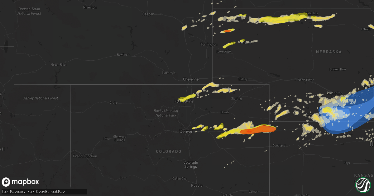
Hail Map on June 20, 2019
Get this storm
June 20 map
$229
one time, instant access
Download today. No call, no setup
Keep the $229
Bought the map and want the full workflow? Apply the entire $229 to a subscription within 7 days. None of it is wasted.
Every map, not just this one
This buys you this map. Subscription and you get every map we run, in the markets you choose from a few cities to whole states to nationwide. Plus real-time alerts the moment a storm fires.
Contact data
Name, contact info, occupancy, even credit band for addresses in the footprint. You go from where it hit to who to call.
Become the source they trust
Unlimited branding weather history reports on demand. You already have the documented answer ready for the property owner, and you are the one who showed up with it.
Property data and RoofTrace estimates
Pull up any address you have got, its value and the exact code rules for that jurisdiction, straight from One Click Code. Then RoofTrace estimates the squares, pitch, and roof value, priced the way you price.
States Impacted by Hail Map on June 20, 2019
Storm reports
Kansas
| Date | Description |
|---|---|
| 06/20/20196:53 AM CDT | 3-inch tree limbs broken; power poles also broken. Report received via mping. |
| 06/20/20196:40 AM CDT | Delayed report: 4 to 6 inch diameter limbs down. |
| 06/20/20196:38 AM CDT | Tree down into power lines. Blown transformer and power out in the city of lansing. |
| 06/20/20196:34 AM CDT | Tree damage at residence. 10 inch diameter tree down. |
| 06/20/20196:18 AM CDT | A local report indicates 59 MPH wind near 4 NNE LAWRENCE |
| 06/20/20196:14 AM CDT | A local report indicates 65 MPH wind near 1 NNW COURTLAND |
| 06/20/20196:00 AM CDT | At 1059 PM CDT, severe thunderstorms were located along a line extending from 9 miles north of Arapahoe to 6 miles southeast of Bartley to near Lebanon, moving northeast at 30 mph. HAZARD...70 mph wind gusts and ping pong ball size hail. SOURCE...Radar indicated. IMPACT...People and animals outdoors will be injured. Expect hail damage to roofs, siding, windows, and vehicles. Expect considerable tree damage. Wind damage is also likely to mobile homes, roofs, and outbuildings. Locations impacted include... Cambridge, Arapahoe, Beaver City, Holbrook, Edison, Wilsonville, Smithfield, Hendley and Hollinger.This Warning replaces the previously-issued Severe Thunderstorm Warning valid until 1115 PM CDT for southern Gosper and northwestern Furnas counties. |
| 06/20/20195:57 AM CDT | Mesonet station kkscourt3. |
| 06/20/20195:52 AM CDT | A local report indicates 60 MPH wind near BURR OAK |
| 06/20/20193:27 AM CDT | At 827 PM MDT/927 PM CDT/, a severe thunderstorm was located 7 miles north of St. Francis, moving northeast at 20 mph. HAZARD...60 mph wind gusts and quarter size hail. SOURCE...Radar indicated. IMPACT...Hail damage to vehicles is expected. Expect wind damage to roofs, siding, and trees. Locations impacted include... St. Francis, Benkelman and Wheeler. |
| 06/20/20193:26 AM CDT | At 825 PM CDT, a severe thunderstorm was located near Goff, moving east at 15 mph. HAZARD...60 mph wind gusts and quarter size hail. SOURCE...Radar indicated. IMPACT...Hail damage to vehicles is expected. Expect wind damage to roofs, siding, and trees. Locations impacted include... Wetmore, Corning, Netawaka, Goff, Woodlawn and Kickapoo Reservation. |
| 06/20/20192:43 AM CDT | At 741 PM CDT, a severe thunderstorm was located 4 miles east of Centralia, moving east at 30 mph. HAZARD...Golf ball size hail and 60 mph wind gusts. SOURCE...Trained weather spotters. At 720 PM CDT...trained spotters reported golfball size hail 4 miles north of Vermillion. IMPACT...People and animals outdoors will be injured. Expect hail damage to roofs, siding, windows, and vehicles. Expect wind damage to roofs, siding, and trees. Locations impacted include... Seneca, Centralia, Wetmore, Corning, Netawaka, Goff, Powhattan, Kickapoo Reservation and Woodlawn. |
| 06/20/20192:37 AM CDT | At 737 PM MDT/837 PM CDT/, severe thunderstorms were located along a line extending from 14 miles south of Eckley to 12 miles northwest of Bonny Reservoir, moving east at 30 mph. HAZARD...Golf ball size hail and 60 mph wind gusts. SOURCE...Law enforcement reported golf ball sized hail from this storm. IMPACT...People and animals outdoors will be injured. Expect hail damage to roofs, siding, windows, and vehicles. Expect wind damage to roofs, siding, and trees. Locations impacted include... St. Francis, Haigler, Beecher Island, Wheeler, Idalia and Vernon. This includes Highway 385 between mile markers 214 and 241. |
| 06/20/20191:56 AM CDT | At 655 PM CDT, a severe thunderstorm was located 5 miles northwest of Vermillion, moving east at 20 mph. HAZARD...60 mph wind gusts and half dollar size hail. SOURCE...Radar indicated. IMPACT...Hail damage to vehicles is expected. Expect wind damage to roofs, siding, and trees. Locations impacted include... Seneca, Frankfort, Centralia, Axtell, Beattie, Corning, Vermillion, Oneida and Baileyville. |
| 06/20/201912:00 AM CDT | A local report indicates 59 MPH wind near 1 W LOGAN |
| 06/19/201911:23 PM CDT | Norton county dispatch reports numerous tree down around the town of norton. |
| 06/19/20197:20 PM CDT | A local report indicates 1.75 inch wind near 4 N VERMILLION |
| 06/19/20197:16 PM CDT | A local report indicates 1.00 inch wind near 4 N VERMILLION |
New Jersey
| Date | Description |
|---|---|
| 06/20/20193:40 PM CDT | Delayed report. Downed tree on u.s. Highway 9 southbound north of state highway 166 in beachwood. All lanes were closed. |
| 06/20/20193:16 PM CDT | Trees down on sweetmans lane and emory court blocking the roadway. Time estimated from radar. |
| 06/20/20192:58 PM CDT | Delayed report. Several downed trees on and near i-195 near exit 1. Lane restrictions were required. Time estimated from radar. |
| 06/20/20192:55 PM CDT | Downed tree on i-295 southbound north of exit 57. Lane restrictions were required. Time estimated from radar. |
| 06/19/201911:44 PM CDT | At 442 PM EDT, severe thunderstorms were located along a line extending from Leisure Village to near Seaside Heights to Warren Grove, moving east at 50 mph. HAZARD...60 mph wind gusts and penny size hail. SOURCE...Radar indicated. IMPACT...Damage to roofs, siding, trees, and power lines is possible. Locations impacted include... Toms River, Asbury Park, Lakewood, Barnegat, Beachwood, Manasquan, Point Pleasant Beach, Seaside Heights, Lakehurst, Mantoloking, Leisure Village, Allenwood, Dover Beaches North, Holiday City South, Pleasant Plains, Warren Grove, Cedar Glen West, Leisure Village East, Dover Beaches South and Holiday City-Berkeley. |
| 06/19/201911:06 PM CDT | At 405 PM EDT, a severe thunderstorm was located over Windsor, or 11 miles east of Trenton, moving northeast at 35 mph. HAZARD...60 mph wind gusts and penny size hail. SOURCE...Radar indicated. IMPACT...Damage to roofs, siding, trees, and power lines is possible. Locations impacted include... Trenton, Long Branch, Sandy Hook, Middletown, Old Bridge, East Brunswick, Sayreville, Marlboro, Manalapan, Tinton Falls, Holmdel, Red Bank, Matawan, Jamesburg, Hightstown, Highlands, Cranbury, Allentown, Roosevelt and Brownville. |
South Dakota
| Date | Description |
|---|---|
| 06/20/20196:33 AM CDT | At 1133 PM CDT/1033 PM MDT/, a severe thunderstorm was located 8 miles northeast of Medicine Lake, or 34 miles southeast of Martin, moving east at 30 mph. HAZARD...60 mph wind gusts and half dollar size hail. SOURCE...Radar indicated. IMPACT...Hail damage to vehicles is expected. Expect wind damage to roofs, siding, and trees. Locations impacted include... Cody, Kilgore, Nenzel, Schoolhouse Lake, Steer Creek Campground and Anderson Bridge State Wildlife Management Area.This includes the following highways... Highway 20 between mile markers 148 and 180. Highway 97 between mile markers 121 and 125. |
| 06/20/20194:09 AM CDT | At 909 PM MDT, a severe thunderstorm was located 9 miles south of Gordon, moving east at 25 mph. HAZARD...60 mph wind gusts and half dollar size hail. SOURCE...Radar indicated. IMPACT...Hail damage to vehicles is expected. Expect wind damage to roofs, siding, and trees. Locations impacted include... Gordon, Merriman, Highway 61 crossing the Snake River, Highway 61 Crossing The Niobrara River, Irwin, Intersection of Highway 61 and Shadbolt Road, Highway 27 crossing the Niobrara River, Intersection of Highway 20 and Irwin Road, Rock Hill, Bayonne and Intersection of Highway 27 and Mills Road.This includes the following highways... Highway 20 between mile markers 101 and 135. Highway 61 between mile markers 200 and 225. |
| 06/20/20192:27 AM CDT | At 726 PM MDT, severe thunderstorms were located along a line extending from 9 miles southeast of Oelrichs to 10 miles south of Crawford, moving northeast at 40 mph. HAZARD...70 mph wind gusts and quarter size hail. SOURCE...Radar indicated. IMPACT...Hail damage to vehicles is expected. Expect considerable tree damage. Wind damage is also likely to mobile homes, roofs, and outbuildings. Severe thunderstorms will be near... Chadron Campground and Red Cloud Campground around 800 PM MDT.Other locations impacted by these severe thunderstorms includeWhitney and Chadron St Park. |
Florida
| Date | Description |
|---|---|
| 06/20/20194:27 AM CDT | At 927 PM EDT, severe thunderstorms were located along a line extending from near Race Pond to 7 miles southwest of Stephen Foster State Park, moving southeast at 35 mph. HAZARD...60 mph wind gusts. SOURCE...Radar indicated. IMPACT...Expect damage to roofs, siding, and trees. Locations impacted include... Hilliard, Folkston, Woodbine, Stephen Foster State Park, Homeland, Kings Ferry, St. George, Race Pond, Winokur and Tarboro. |
| 06/20/20192:46 AM CDT | At 746 PM EDT, a severe thunderstorm was located 8 miles west of Colquitt, moving southeast at 35 mph. HAZARD...60 mph wind gusts. SOURCE...Radar indicated. IMPACT...Expect damage to roofs, siding, and trees. Locations impacted include... Colquitt, Donalsonville, Centerville, Iron City, Damascus, Brinson, Jakin, Saffold, Ausmac, Babcock, Little Hope, Mayhaw, Decatur Co A/P, Boykin, Riverturn, Sharphagen, Donaldsonville A/P, Branchville, Hentown and Bellview. |
Vermont
| Date | Description |
|---|---|
| 06/20/20191:42 PM CDT | Tree down on powerline near norwich |
| 06/20/20191:40 PM CDT | Multiple trees and limbs on power lines near hartford/west hartford. |
| 06/20/20191:30 PM CDT | Tree down and power outage on middle road. |
| 06/20/201912:45 PM CDT | Tree on powerline. |
| 06/20/201912:42 PM CDT | Tree down on forest street/no power |
| 06/20/201912:40 PM CDT | Tree down on powerlines. |
Iowa
| Date | Description |
|---|---|
| 06/20/20193:37 AM CDT | At 837 PM CDT, a severe thunderstorm was located near Elmore, or 15 miles east of Fairmont, moving southeast at 20 mph. HAZARD...Ping pong ball size hail and 60 mph wind gusts. SOURCE...Radar indicated. IMPACT...People and animals outdoors will be injured. Expect hail damage to roofs, siding, windows, and vehicles. Expect wind damage to roofs, siding, and trees. This severe thunderstorm will be near... Elmore around 855 PM CDT.This includes U.S. Highway 169 between mile markers 1 and 7. |
| 06/20/20193:30 AM CDT | A local report indicates 1.00 inch wind near WHITING |
| 06/20/20192:55 AM CDT | At 755 PM CDT, a severe thunderstorm was located near Truman, or 10 miles northeast of Fairmont, moving southeast at 25 mph. HAZARD...Golf ball size hail and 70 mph wind gusts. SOURCE...Trained weather spotters. IMPACT...People and animals outdoors will be injured. Expect hail damage to roofs, siding, windows, and vehicles. Expect considerable tree damage. Wind damage is also likely to mobile homes, roofs, and outbuildings. This severe thunderstorm will be near... Winnebago around 810 PM CDT. Blue Earth around 835 PM CDT.Other locations impacted by this severe thunderstorm include FairmontAirport, Huntley, East Chain, Imogene, Northrop, Granada and Guckeen.This includes the following highways... Interstate 90 between mile markers 103 and 124. U.S. Highway 169 between mile markers 8 and 19. |
| 06/20/20192:51 AM CDT | At 750 PM CDT, a severe thunderstorm was located near Moorhead, or 27 miles west of Denison, moving southeast at 25 mph. HAZARD...60 mph wind gusts and quarter size hail. SOURCE...Radar indicated. IMPACT...Hail damage to vehicles is expected. Expect wind damage to roofs, siding, and trees. Locations impacted include... Moorhead, Woodbine, Dunlap, Soldier, Castana, Turin, Preparation Canyon State Park and Schaben Park. |
| 06/20/20192:23 AM CDT | At 722 PM CDT, a severe thunderstorm was located over Onawa, or 35 miles southeast of Sioux City, moving southeast at 15 mph. HAZARD...60 mph wind gusts and quarter size hail. SOURCE...Radar indicated. IMPACT...Hail damage to vehicles is expected. Expect wind damage to roofs, siding, and trees. Locations impacted include... Onawa, Ute, Moorhead, Soldier, Castana, Turin, Lewis And Clark State Park, Kennebec and Preparation Canyon State Park.This includes Interstate 29 between mile markers 109 and 115. |
| 06/19/20197:45 PM CDT | Delayed report. Time estimated based on radar data. |
Maryland
| Date | Description |
|---|---|
| 06/19/20199:33 PM CDT | At 232 PM EDT, severe thunderstorms were located along a line extending from Lionville to Kemblesville, moving east at 30 mph. HAZARD...60 mph wind gusts and penny size hail. SOURCE...Radar indicated. IMPACT...Damage to roofs, siding, trees, and power lines is possible. Locations impacted include... Philadelphia, Wilmington, Newark, West Chester, Norristown, Chester, Phoenixville, West Norriton, East Norriton, Pennsville, Coatesville, Yeadon, Westtown, Carneys Point, Downingtown, Conshohocken, Hatboro, Folcroft, Ambler and Swarthmore. |
Georgia
| Date | Description |
|---|---|
| 06/20/20196:58 PM CDT | A few trees down near highway 125 just northwest of nashville... Ga. |
| 06/20/20196:44 PM CDT | Bulloch 911 reported a tree down on deloach church rd at nevills groveland rd. |
| 06/20/20196:40 PM CDT | Multiple trees and power lines reported down throughout the northern portions of ware county. |
| 06/20/20196:40 PM CDT | Reports of countywide trees and powerlines down across pierce county. |
| 06/20/20196:39 PM CDT | Bulloch 911 reported a tree down on golf club dr at us301s. |
| 06/20/20196:35 PM CDT | Reports of trees and power lines down throughout appling county... With reports of trees having fallen on vehicles... But no structural damage has been observed. |
| 06/20/20196:30 PM CDT | Bulloch 911 reported a tree down near the intersection of ga169 and ga129. |
| 06/20/20196:20 PM CDT | Tree down near 200 camp ground church rd in coffee county. |
| 06/20/20196:20 PM CDT | Tree down near stagecoach road. |
| 06/20/20196:10 PM CDT | Tree across the line on tyty whiddon mill road. |
| 06/20/20196:10 PM CDT | Trees and powerlines reported down in willacoochee area. |
| 06/20/20196:08 PM CDT | Multiple power lines down in atkinson county... With 2 trees reported down near willacochee. |
| 06/20/20196:00 PM CDT | Several trees reported down in the area by 911 center. |
| 06/20/20195:55 PM CDT | Tree down on mcgirt st in poulan. |
| 06/20/20195:55 PM CDT | Tree was reported down in broxton. Time estimated from radar. |
| 06/20/20195:45 PM CDT | Bulloch 911 reported a power line down on randy lowery rd. |
| 06/20/20195:33 PM CDT | Tree down between ocilla and tifton... Ga near highway 319. |
| 06/20/20195:30 PM CDT | Tree down on highway 107 between lands crossing and prospect church rd. |
| 06/20/20195:30 PM CDT | Several trees down in early county. |
| 06/20/20195:30 PM CDT | Part of a tree blocking half of the south bound lane on highway 82 west. |
| 06/20/20195:30 PM CDT | Tree down on dirt end of bussell pond off of pinetta. |
| 06/20/20195:25 PM CDT | Tree down at isabella terrell rd close to worth turner rd. |
| 06/20/20195:23 PM CDT | Tree down on cannon road. |
| 06/20/20195:20 PM CDT | 2 trees down near bluffton road. |
| 06/20/20195:17 PM CDT | Tree down on brannens bridge road. |
| 06/20/20195:15 PM CDT | Tree down on highway 313 at medders. |
| 06/20/20195:15 PM CDT | Screven 911 reported a tree down on a power line and partially blocking the road on n main st in sylvania. |
| 06/20/20195:12 PM CDT | Tree down on ga hwy 17s near county line. |
| 06/20/20195:10 PM CDT | Tree down on bay branch road. |
| 06/20/20195:08 PM CDT | Tree blown down in the town of rhine. |
| 06/20/20195:04 PM CDT | Tree reported down on jaybird springs rd near jaybird springs. |
| 06/20/20194:53 PM CDT | Tree down on us hwy 25 n. |
| 06/20/20194:45 PM CDT | Tree down on ga 17 n. |
| 06/20/20194:30 PM CDT | 2-3 trees down on ga hwy 27 at mile marker 7... Ne of intersection with snow rd. |
| 06/20/20194:23 PM CDT | Trees down on 300 to 700 block of scenic route near lake blackshear |
| 06/20/20193:58 PM CDT | Tree and power lines reported down at the 1400 block of willow lake rd. |
| 06/20/20193:55 PM CDT | Trees down along benevolence highway. |
| 06/20/20193:51 PM CDT | Tree down on ga hwy 27 at mm 10 near the intersection of canyon rd. |
| 06/20/20193:51 PM CDT | Tree down on powerline on ga hwy 39... Just west of the intersection of hwy 27 |
| 06/20/20193:43 PM CDT | Trees down at highway 82 and moore station road. |
| 06/20/20193:40 PM CDT | At least 1 tree down at intersection of ga hwy 49 and forest hill rd sw. |
| 06/20/20193:39 PM CDT | Over a dozen trees reported down throughout the southern portion of balwin county... Mostly centered around scottsboro but including areas of hardwick/allenwood |
| 06/20/20193:35 PM CDT | The asos at thomson-mcduffie county airport recorded a wind gust of 69 mph. |
| 06/20/20193:20 PM CDT | A tree was reported down on sr 18 east and west at camelot road. |
| 06/20/20193:14 PM CDT | Gdot reports 2 trees down on i-75 sb blocking all lanes at exit 172 at bass rd |
| 06/20/20193:12 PM CDT | A tree was reported down on sr 87 north and south at christian road. |
| 06/20/20193:08 PM CDT | 2 trees reported down... One on christmas ln and another on stallings rd |
| 06/20/20193:08 PM CDT | A tree was reported down on interstate 475 at sr 19/us 41/dixie highway. |
| 06/20/20192:56 PM CDT | Total of 50-100 trees down beginning at 42 south and maynards mill rd... Continuing east. |
| 06/20/20192:35 PM CDT | Utility company reported a tree down on indian rd... Also knocking down power lines in lincoln county. Time estimated by radar. |
| 06/20/20192:35 PM CDT | Tree down at intersection of delray rd and rocky bottom rd. |
| 06/20/20192:32 PM CDT | Six pecan trees were reported down and caused damage to a barn and barn equipment in addition to two camper vehicles. |
| 06/20/20192:23 PM CDT | Reported trees down along gills point road near lake thurmond. |
| 06/20/20192:18 PM CDT | Tree blown down on power lines on hwy 85 near greenville flat shoals rd |
| 06/20/20192:18 PM CDT | Two trees down on lawrence mill rd near kelly rd |
| 06/20/20192:15 PM CDT | 911 call center reported a large area of about 40 trees down on wahatchee creek rd. |
| 06/20/20192:11 PM CDT | Law enforcement reported a power outage due to wind from a severe thunderstorm on shoreline drive in lincoln county. Time estimated by radar. |
| 06/20/20192:10 PM CDT | At least 4 trees down at render garrett rd and ga hwy 100. |
| 06/20/20192:05 PM CDT | Reports of numerous trees down near greenville including damage around the town square. |
| 06/20/20192:00 PM CDT | 911 call center reported trees down on washington hwy. |
| 06/20/20192:00 PM CDT | 911 call center reported trees down on bakers ferry rd & edison rd. |
| 06/20/20192:00 PM CDT | 911 call center reported trees down on mineral springs rd & fleming road ext. |
| 06/20/20191:42 PM CDT | 1-2 trees down near us78 and yancy rd. |
| 06/20/20191:41 PM CDT | Multiple trees and power lines were reported down on athens road... Smokey ridge road and wolfskin road. |
| 06/20/20191:25 PM CDT | 1-2 trees down near us78 and yancy rd. |
| 06/20/201912:55 PM CDT | Several trees down on the north side of of county farm rd bewteen hwt 82 n and i w davis rd |
| 06/20/20193:49 AM CDT | At 848 PM EDT, a severe thunderstorm was located near Argyle, moving southeast at 45 mph. HAZARD...60 mph wind gusts. SOURCE...Radar indicated. IMPACT...Expect damage to roofs, siding, and trees. Locations impacted include... Argyle, Stephen Foster State Park, Race Pond and Manor. |
| 06/20/20193:07 AM CDT | At 807 PM EDT, a severe thunderstorm was located near Blackshear, moving southeast at 35 mph. HAZARD...60 mph wind gusts. SOURCE...Radar indicated. IMPACT...Expect damage to roofs, siding, and trees. Locations impacted include... Waycross, Blackshear, Nahunta, Patterson, Offerman, Hickox, Boggy Bay, Raybon, Race Pond and Waynesville. |
| 06/20/20192:40 AM CDT | At 740 PM EDT, severe thunderstorms were located along a line extending from Pelham to near Alapaha, moving southeast at 35 mph. HAZARD...60 mph wind gusts. SOURCE...Radar indicated. In addition, trees have been reported down with these storms. IMPACT...Expect damage to roofs, siding, and trees. Locations impacted include... Nashville, Moultrie, Adel, Valdosta, Lakeland, Pelham, Camilla, Hahira, Sparks, Ray City, Norman Park, Lenox, Ochlocknee, Pavo, Coolidge, Moody Air Force Base, Riverside, Schley, Meigs and Morven. |
| 06/20/20192:39 AM CDT | At 739 PM EDT, severe thunderstorms were located along a line extending from Surrency to 10 miles north of Du Pont, moving southeast at 45 mph. HAZARD...60 mph wind gusts. SOURCE...Radar indicated. IMPACT...Expect damage to roofs, siding, and trees. Locations impacted include... Waycross, Jesup, Blackshear, Homerville, Patterson, Argyle, Surrency, Gardi, Screven and Odum. |
| 06/20/20191:49 AM CDT | At 649 PM EDT, severe thunderstorms were located along a line extending from Alston to 6 miles south of Enigma, moving southeast at 45 mph. HAZARD...60 mph wind gusts. SOURCE...Radar indicated. IMPACT...Expect damage to roofs, siding, and trees. Locations impacted include... Douglas, Baxley, Hazlehurst, Alma, Homerville, Pearson, Willacoochee, Broxton, Ambrose and Graham. |
| 06/20/20191:24 AM CDT | At 624 AM EDT, a severe thunderstorm was located over Funkhouser, or 14 miles southeast of Calhoun, moving east at 50 mph. HAZARD...60 mph wind gusts. SOURCE...Radar indicated. IMPACT...Expect damage to roofs, siding, and trees. Locations impacted include... Jasper, White, Waleska, Talking Rock, Fairmount, Salacoa Valley, Pine Log, Blaine, Talmadge, Folsom, Funkhouser and Hinton. |
| 06/20/20191:20 AM CDT | At 619 PM EDT, severe thunderstorms were located along a line extending from 8 miles northeast of Fitzgerald to 6 miles east of Marine Corps Logistics Base, moving east at 35 mph. HAZARD...60 mph wind gusts. SOURCE...Radar indicated. IMPACT...Expect damage to roofs, siding, and trees. Locations impacted include... Tifton, Nashville, Ocilla, Fitzgerald, Sylvester, Moultrie, Ashburn, Adel, Sparks, Enigma, Omega, Norman Park, Lenox, Poulan, Doerun, Ty Ty, Alapaha, Phillipsburg, Mystic and Unionville. |
| 06/20/20191:17 AM CDT | At 616 PM EDT, a severe thunderstorm was located near Alamo, moving east at 45 mph. HAZARD...60 mph wind gusts. SOURCE...Radar indicated. IMPACT...Expect damage to roofs, siding, and trees. Locations impacted include... McRae, Lyons, Soperton, Alamo, Mount Vernon, Vidalia, Helena, Lumber City, Glenwood, Uvalda, Stillmore, Oak Park, Ailey, Scotland, Higgston, Santa Claus, Alston, Jacksonville, Tarrytown and Towns. |
| 06/20/20191:06 AM CDT | At 606 PM EDT, severe thunderstorms were located along a line extending from 6 miles northeast of Barnwell to near Plant Vogtle, moving east at 70 mph. HAZARD...60 mph wind gusts. SOURCE...Radar indicated. IMPACT...Expect damage to trees and powerlines. Locations impacted include... Allendale, Fairfax, Sycamore, Ulmer, Seigling, Millett, Martin and Barton. |
| 06/20/20191:02 AM CDT | At 602 PM EDT, severe thunderstorms were located along a line extending from near Helena to near Sylvester, moving southeast at 40 mph. HAZARD...60 mph wind gusts. SOURCE...Radar indicated. IMPACT...Expect damage to roofs, siding, and trees. Locations impacted include... Douglas, Hazlehurst, Pearson, Willacoochee, Broxton, Ambrose, Nicholls, Pridgen, West Green and Snipesville. |
| 06/20/20191:01 AM CDT | At 601 AM EDT, a severe thunderstorm was located near Rome, moving east at 55 mph. HAZARD...60 mph wind gusts. SOURCE...Radar indicated. IMPACT...Expect damage to roofs, siding, and trees. Locations impacted include... Rome, Cartersville, Adairsville, White, Kingston, Cassville, Shannon, Pine Log and Folsom. |
| 06/20/201912:57 AM CDT | At 555 AM EDT/455 AM CDT/, severe thunderstorms were located along a line extending from 10 miles west of Pikeville to 6 miles north of Whitwell to near Signal Mountain to near La Fayette, moving northeast at 50 mph. HAZARD...70 mph wind gusts. SOURCE...Law enforcement. IMPACT...Expect considerable tree damage. Damage is likely to mobile homes, roofs, and outbuildings. Locations impacted include... Chattanooga, Cleveland, Dayton, Dunlap, Pikeville, Decatur, Soddy-Daisy, Signal Mountain, Rossville, Walden, Lakesite, Whitwell, Charleston, Ridgeside, Harrison, East Cleveland, South Cleveland, Fairmount, Wildwood Lake and Red Bank. |
| 06/20/201912:49 AM CDT | At 549 PM EDT, a severe thunderstorm was located over Seville, or 8 miles east of Cordele, moving east at 55 mph. HAZARD...60 mph wind gusts and quarter size hail. SOURCE...Radar indicated. IMPACT...Hail damage to vehicles is expected. Expect wind damage to roofs, siding, and trees. Locations impacted include... Cordele, Eastman, Abbeville, Rochelle, Milan, Arabi, Pineview, Rhine, Chauncey, Pitts, Jacksonville, Union, Seville, Ocmulgee Banks, Finleyson, Jay Bird Springs, China Hill, Pleasant View, Tippettville and Double Run. |
| 06/20/201912:48 AM CDT | At 547 PM EDT, a severe thunderstorm was located near Mayday, or 8 miles northwest of Statenville, moving east at 40 mph. HAZARD...60 mph wind gusts. SOURCE...Radar indicated. IMPACT...Expect damage to roofs, siding, and trees. Locations impacted include... Statenville, Du Pont and Mayday. |
| 06/20/201912:45 AM CDT | At 545 PM EDT, severe thunderstorms were located along a line extending from Pitts to near Leslie, moving east at 40 mph. HAZARD...60 mph wind gusts and penny size hail. SOURCE...Radar indicated. IMPACT...Expect damage to roofs, siding, and trees. Locations impacted include... Fitzgerald, Sylvester, Ashburn, Ocilla, Poulan, Ty Ty, Mystic, Worth, Terrell, Sycamore, Sumner, Warwick, Rebecca, Chokee, Amboy, Osierfield, Sylvester Airport, Tempy, Harding and Waterloo. |
| 06/20/201912:39 AM CDT | At 539 PM EDT, severe thunderstorms were located along a line extending from Three Points to Kite, moving east at 55 mph. HAZARD...60 mph wind gusts and quarter size hail. SOURCE...Radar indicated. IMPACT...Hail damage to vehicles is expected. Expect wind damage to roofs, siding, and trees. Locations impacted include... Garfield, Summertown, Three Points, Dellwood, Modoc, Canoochee and Blundale. |
| 06/20/201912:31 AM CDT | At 531 PM EDT, severe thunderstorms were located along a line extending from 9 miles northwest of Millen to 10 miles northwest of Swainsboro, moving east at 45 mph. HAZARD...60 mph wind gusts and penny size hail. SOURCE...Radar indicated. IMPACT...Expect damage to trees and powerlines. Locations impacted include... Statesboro, Metter, Millen, Sylvania, Middleground, Westside, Butts and Portal. |
| 06/20/201912:30 AM CDT | At 530 PM EDT, a severe thunderstorm was located over Hartford, or over Hawkinsville, moving east at 45 mph. HAZARD...60 mph wind gusts and quarter size hail. SOURCE...Radar indicated. IMPACT...Hail damage to vehicles is expected. Expect wind damage to roofs, siding, and trees. Locations impacted include... Dublin, Cochran, Eastman, Hawkinsville, Chester, Dexter, Dudley, Cadwell, Rentz, Dubois, Browndale, Plainfield, Empire, Cedar Grove, Mobley Crossing, Mock Springs, Roddy, Baileys Park, Rowland and Harlow. |
| 06/20/201912:28 AM CDT | At 528 PM EDT, a severe thunderstorm was located 7 miles west of Lake Park, moving northeast at 30 mph. HAZARD...60 mph wind gusts. SOURCE...Radar indicated. IMPACT...Expect damage to roofs, siding, and trees. Locations impacted include... Lake Park, Valdosta, I-75 At Exit 16, Moody Air Force Base, Remerton, Dasher, Naylor, Greenwood, Twin Lakes, Valdosta Regional Airport, Kinderlou, I-75 At Exit 5, Clyattville, I-75 At Exit 11 and Stockton. |
| 06/20/201912:25 AM CDT | At 525 PM EDT, a severe thunderstorm was located over Croxton Crossroads, or 10 miles southwest of Americus, moving east at 45 mph. HAZARD...60 mph wind gusts and quarter size hail. SOURCE...Radar indicated. IMPACT...Hail damage to vehicles is expected. Expect wind damage to roofs, siding, and trees. Locations impacted include... Americus, Plains, Byromville, Lilly, Dooling, Sumter, Lamar, Croxton Crossroads, New Era, Flint River Wma, Huntington, Pennington, Drayton, Maddox and Methvins. |
| 06/20/201912:21 AM CDT | At 520 PM EDT, a severe thunderstorm was located over Cobb, or 11 miles west of Cordele, moving east at 35 mph. HAZARD...60 mph wind gusts and quarter size hail. SOURCE...Radar indicated. IMPACT...Hail damage to vehicles is expected. Expect wind damage to roofs, siding, and trees. Locations impacted include... Cordele, Vienna, Arabi, Leslie, De Soto, Desoto, Cobb, East Crisp, Fort Early, Georgia Veterans Memorial St Pk, Richwood, Hatley, Tippettville, Raines, Tremont and Wenona. |
| 06/20/201912:17 AM CDT | At 517 PM EDT, a severe thunderstorm was located near Riddleville, or 11 miles east of Sandersville, moving east at 50 mph. HAZARD...60 mph wind gusts and quarter size hail. SOURCE...Radar indicated. IMPACT...Hail damage to vehicles is expected. Expect wind damage to roofs, siding, and trees. Locations impacted include... Louisville, Wadley, Bartow, Summertown, Three Points, Moxley, Blundale and Colemans Lake. |
| 06/19/201911:57 PM CDT | At 457 PM EDT, a severe thunderstorm was located near Hebron, or 9 miles northeast of Irwinton, moving east at 30 mph. HAZARD...60 mph wind gusts and penny size hail. SOURCE...Radar indicated. IMPACT...Expect damage to roofs, siding, and trees. Locations impacted include... Sandersville, Wrightsville, Irwinton, Davisboro, Tennille, McIntyre, Harrison, Toomsboro, Oconee, Deepstep, Riddleville, Downs, Beulah, Donovan, Warthen, Underwood, Linton, Grange, Pringle and Hebron. |
| 06/19/201911:55 PM CDT | At 455 PM EDT, a severe thunderstorm was located near Shellman, or near Cuthbert, moving east at 45 mph. HAZARD...60 mph wind gusts and quarter size hail. SOURCE...Radar indicated. IMPACT...Hail damage to vehicles is expected. Expect wind damage to roofs, siding, and trees. Locations impacted include... Dawson, Leesburg, Shellman, Smithville, Sasser, Bronwood, Parrott, Pachitla, Bridges Crossroad, Jordan Place, Yeomans, Dawson Municipal A/P, Graves, Oakville, Chambliss, Olivers Mill, Brooksville, Benevolence and Wades. |
| 06/19/201911:35 PM CDT | At 435 PM EDT, a severe thunderstorm was located 7 miles west of Cuthbert, moving east at 50 mph. HAZARD...60 mph wind gusts and penny size hail. SOURCE...Radar indicated. IMPACT...Expect damage to roofs, siding, and trees. Locations impacted include... Cuthbert, Shellman, Parrott, Springvale Station, Pachitla, Peterson Hill, Coles, White House, Graves, Chambliss, Morris, Brooksville, Benevolence, Springvale, Cotton Hill and Wades. |
| 06/19/201911:17 PM CDT | At 417 PM EDT, a severe thunderstorm was located over Springfield, or 8 miles north of Sparta, moving east at 45 mph. HAZARD...60 mph wind gusts and nickel size hail. SOURCE...Radar indicated. IMPACT...Expect damage to roofs, siding, and trees. Locations impacted include... Warrenton, Stapleton, Norwood, Camak, Springfield, Jewell, Beall Springs, Mayfield, Powelton, Reese, Mesena, Bastonville, Culverton and Barnett. |
| 06/19/201911:14 PM CDT | At 414 PM EDT, a severe thunderstorm was located near Arkwright, or 8 miles southwest of Gray, moving east at 55 mph. HAZARD...70 mph wind gusts and penny size hail. SOURCE...Radar indicated. IMPACT...Expect considerable tree damage. Damage is likely to mobile homes, roofs, and outbuildings. Locations impacted include... Macon, Milledgeville, Gray, Irwinton, Gordon, Ivey, McIntyre, Payne, Payne City, Midway-Hardwick, Postell, Bradley, Wayside, Allenwood, Mountain Springs, Griswoldville, Round Oak, Wesleyan, Arkwright and Hardwick. |
| 06/19/201911:09 PM CDT | At 409 AM CDT, severe thunderstorms were located along a line extending from near Crossville to near Ballplay to near Glencoe, moving northeast at 55 mph. HAZARD...60 mph wind gusts and penny size hail. SOURCE...Radar indicated. IMPACT...Expect damage to roofs, siding, and trees. Locations impacted include... Centre, Cedar Bluff, Little River Canyon National Preserve, Forney, Centre Municipal Airport, Leesburg, Sand Rock, Gaylesville, Tennala, Cherokee Rock Village, Cornwall Furnace Park, Blanche, Eastern Weiss Lake, Little River Falls, Slackland, Western Weiss Lake, Moshat, Ball Flat, Coloma and Weiss Dam. |
| 06/19/201910:57 PM CDT | At 357 PM EDT, a severe thunderstorm was located over Cadley, or 10 miles northwest of Thomson, moving east at 30 mph. HAZARD...60 mph wind gusts and quarter size hail. SOURCE...Radar indicated. IMPACT...Hail damage to vehicles is expected. Expect wind damage to roofs, siding, and trees. Locations impacted include... Cadley. |
| 06/19/201910:44 PM CDT | At 344 PM EDT, a severe thunderstorm was located over The Rock, or near Barnesville, moving east at 50 mph. HAZARD...60 mph wind gusts and quarter size hail. SOURCE...Radar indicated. IMPACT...Hail damage to vehicles is expected. Expect wind damage to roofs, siding, and trees. Locations impacted include... Macon, Thomaston, Barnesville, Forsyth, Yatesville, Payne, Meansville, Aldora, Payne City, The Rock, Bolingbroke, Dames Ferry, Russellville, Brent, Jarrell Plantation, Wesleyan, Redbone, Arkwright, Collier and Piedmont. |
| 06/19/201910:39 PM CDT | At 338 PM EDT, a severe thunderstorm was located near Juliette, or 10 miles south of Monticello, moving east at 35 mph. HAZARD...60 mph wind gusts and half dollar size hail. SOURCE...Radar indicated. IMPACT...Hail damage to vehicles is expected. Expect wind damage to roofs, siding, and trees. Locations impacted include... Milledgeville, Meriwether, Ethridge, Bradley, Wayside, Berner, Haddock, Resseaus Crossroads, Round Oak, Plant Harlee Branch, Hillsboro, Browns Crossing, Juliette, Stanfordville and Blountsville. |
| 06/19/201910:33 PM CDT | At 332 PM EDT, a severe thunderstorm was located over Fayetteville, moving east at 40 mph. HAZARD...60 mph wind gusts and quarter size hail. SOURCE...Radar indicated. IMPACT...Hail damage to vehicles is expected. Expect wind damage to roofs, siding, and trees. Locations impacted include... McDonough, Fayetteville, Jonesboro, Stockbridge, Riverdale, Lovejoy, Lake Spivey, Blacksville, Bonanza, Jw Smith Reservoir, Flippen, Eagles Landing and Irondale. |
| 06/19/201910:23 PM CDT | At 321 PM EDT, a severe thunderstorm was located over Molena, or 10 miles east of Greenville, moving east at 45 mph. HAZARD...60 mph wind gusts and penny size hail. SOURCE...Radar indicated. This storm has a history of producing widespread wind damage. IMPACT...Expect damage to roofs, siding, and trees. Locations impacted include... Thomaston, Barnesville, Zebulon, Molena, Yatesville, Meansville, Culloden, Aldora, The Rock, Sunset Village, Atwater, Goggins, Lifsey Springs, Crest, Redbone, Hannahs Mill, Piedmont and Johnstonville. |
| 06/19/20199:48 PM CDT | At 248 PM EDT, a severe thunderstorm was located over Mountville, or 7 miles east of LaGrange, moving east at 35 mph. HAZARD...60 mph wind gusts and penny size hail. SOURCE...Radar indicated. IMPACT...Expect damage to roofs, siding, and trees. Locations impacted include... LaGrange, Greenville, Woodbury, Molena, Gay, Raleigh, Mountville, Louise, Odessadale, Stovall, Big Springs, Durand, Harris City and Imlac. |
| 06/19/20199:41 PM CDT | At 240 PM EDT, a severe thunderstorm was located over Vesta, or 9 miles northeast of Lexington, moving east at 45 mph. HAZARD...60 mph wind gusts and nickel size hail. SOURCE...Radar indicated. IMPACT...Expect damage to roofs, siding, and trees. Locations impacted include... Lexington, Crawford, Tignall, Arnoldsville, Carlton, Rayle, Athens-Clarke County, Jacksons Crossroads, Mallorysville, Delhi, Norman, Smithonia, Hutchings, Metasville, Floral Hill, Newtown, Danburg, Celeste, Watson Mill Bridge State Park and Vesta. |
| 06/19/20197:15 PM CDT | Multiple reports of trees and power lines down in wayne county... With 2-3 trees reported down near screven. |
| 06/19/20197:00 PM CDT | Several trees down in early county. |
Alabama
| Date | Description |
|---|---|
| 06/20/20191:28 AM CDT | At 628 PM EDT, Doppler radar indicated a line of severe thunderstorms capable of producing damaging winds in excess of 60 mph. These storms were located along a line extending from near Blakely to 9 miles east of Leary, and moving east at 30 mph. Locations impacted include... Newton, Blakely, Putney, Albany, Arlington, Baconton, Columbia, Leary, Douglasville, Centerville, Sale City, Damascus, Iveys Mill, Flint, Parksville, Holt, Rock Hill, Lester, Early Co A/p and Williamsburg. |
| 06/20/20191:04 AM CDT | At 603 PM EDT/503 PM CDT/, a severe thunderstorm was located 9 miles southeast of Abbeville, moving east at 55 mph. HAZARD...60 mph wind gusts and penny size hail. SOURCE...Radar indicated. IMPACT...Expect damage to roofs, siding, and trees. Locations impacted include... Abbeville, Fort Gaines, Morgan, Blakely, Edison, Arlington, Douglasville, Bellville, Haleburg, Bluffton, Shorterville, Iveys Mill, Parksville, Hayes, Early Co A/p, Rowena, Balkum, Harrisons Mill, Barnes and Hardwickburg. |
| 06/20/201912:34 AM CDT | At 533 AM EDT, severe thunderstorms were located along a line extending from Watson to Eastern Weiss Lake to near Coloma, moving northeast at 55 mph. HAZARD...60 mph wind gusts. SOURCE...Radar indicated. IMPACT...Expect damage to roofs, siding, and trees. Locations impacted include... Rome, Summerville, Cave Spring, Plainville, Shannon, Lyerly, Pinson, Lindale, Subligna, Tidings, Armuchee, Coosa, Berryton, Chattoogaville, Everett Springs, James H. Floyd State Park and Holland. |
| 06/19/201910:30 PM CDT | At 329 AM CDT, a severe thunderstorm was located 7 miles north of Hazel Green, or 7 miles south of Fayetteville, moving northeast at 45 mph. HAZARD...60 mph wind gusts. SOURCE...Radar indicated. IMPACT...Expect damage to roofs, siding, and trees. Locations impacted include... Winchester, Lynchburg, Decherd, Estill Springs, Cowan, Huntland, Tims Ford Lake, Sewanee, Anderson and Lincoln. |
| 06/19/201910:25 PM CDT | At 324 AM CDT, severe thunderstorms were located along a line extending from Brooksville to Argo, moving east at 55 mph. HAZARD...60 mph wind gusts. SOURCE...Radar indicated. IMPACT...Expect damage to roofs, siding, and trees. Locations impacted include... Gadsden, Pell City, Leeds, Moody, Rainbow City, Attalla, Hokes Bluff, Springville, Odenville, Lincoln, Glencoe, Margaret, Argo, Ashville, Riverside, Sardis City, Ragland, Ohatchee, Steele and Altoona. |
| 06/19/201910:21 PM CDT | At 320 AM CDT, severe thunderstorms were located along a line extending from near New Market to near Oneonta, moving east at 45 mph. HAZARD...60 mph wind gusts. SOURCE...Radar indicated. IMPACT...Expect damage to roofs, siding, and trees. Locations impacted include... Huntsville, Albertville, Scottsboro, Fort Payne, Boaz, Guntersville, Arab, Rainsville, Moores Mill and Meridianville. |
| 06/19/20199:58 PM CDT | At 258 PM CDT, a severe thunderstorm was located over Clio, moving east at 30 mph. HAZARD...60 mph wind gusts and quarter size hail. SOURCE...Radar indicated. IMPACT...Hail damage to vehicles is expected. Expect wind damage to roofs, siding, and trees. Locations impacted include... Clio, Louisville, Tyler Crossroads, Blue Springs State Park and Texasville. |
| 06/19/20199:45 PM CDT | At 245 AM CDT, severe thunderstorms were located along a line extending from near Sardis to West Jefferson, moving east at 50 mph. HAZARD...60 mph wind gusts and penny size hail. SOURCE...Radar indicated. IMPACT...Expect damage to roofs, siding, and trees. Locations impacted include... Oneonta, Blountsville, Cleveland, Dallas, Warrior, Locust Fork, Altoona, Snead, Susan Moore, Walnut Grove, Trafford, Allgood, Fairview, Hayden, Nectar, Rosa, County Line, McLarty, Bangor and Strawberry. |
| 06/19/20199:44 PM CDT | At 244 AM CDT, severe thunderstorms were located along a line extending from 7 miles north of Trinity to near Sipsey, moving east at 40 mph. HAZARD...60 mph wind gusts and quarter size hail. SOURCE...Radar indicated. IMPACT...Hail damage to vehicles is expected. Expect wind damage to roofs, siding, and trees. Locations impacted include... Decatur, Cullman, Hartselle, Redstone Arsenal, Hanceville, Priceville, Good Hope, Trinity, Falkville and Holly Pond. |
| 06/19/20199:29 PM CDT | At 229 AM CDT, severe thunderstorms were located along a line extending from near Curry to near Bull City to near Forkland, moving east at 45 mph. HAZARD...60 mph wind gusts and penny size hail. SOURCE...Radar indicated. IMPACT...Expect damage to roofs, siding, and trees. Locations impacted include... Birmingham, Hoover, Vestavia Hills, Alabaster, Bessemer, Homewood, Pelham, Mountain Brook, Trussville, Helena, Hueytown, Gardendale, Irondale, Leeds, Moody, Calera, Fairfield, Chelsea, Fultondale and Montevallo. |
| 06/19/20199:07 PM CDT | At 206 AM CDT, severe thunderstorms were located along a line extending from 6 miles northeast of Knoxville to Eutaw to near Boyd, moving east at 45 mph. HAZARD...60 mph wind gusts and penny size hail. SOURCE...Radar indicated. IMPACT...Expect damage to roofs, siding, and trees. Locations impacted include... Greensboro, Moundville, Forkland, Akron, Newbern, Walden Quarters, Thornhill, Arcola, Wedgeworth, Tishabee, Greensboro Municipal Airport, Duffys Bend, Sawyerville, Evansville, Gallion, Moundville Airport, Mound State Park, Elliots Creek, Birdine and Harper Hill. |
| 06/19/20199:03 PM CDT | At 202 AM CDT, severe thunderstorms were located along a line extending from 9 miles north of Underwood-Petersville to near Haleyville, moving east at 50 mph. HAZARD...60 mph wind gusts. SOURCE...Radar indicated. IMPACT...Expect damage to roofs, siding, and trees. Locations impacted include... Decatur, Madison, Florence, Athens, Cullman, Hartselle, Muscle Shoals, Sheffield, Tuscumbia and Moulton. |
| 06/19/20198:52 PM CDT | At 152 AM CDT, severe thunderstorms were located along a line extending from near Phil Campbell to near Fayette to Benevola, moving east at 50 mph. HAZARD...60 mph wind gusts and penny size hail. SOURCE...Radar indicated. IMPACT...Expect damage to roofs, siding, and trees. Locations impacted include... Tuscaloosa, Northport, Jasper, Winfield, Fayette, Haleyville, Sumiton, Cordova, Dora, Carbon Hill, Lynn, Arley, Holt, Lake View, Brookwood, Coaling, Vance, Berry, Double Springs and Parrish. |
| 06/19/20198:36 PM CDT | At 135 AM CDT, severe thunderstorms were located along a line extending from near Red Bay to near Hamilton, moving east at 50 mph. HAZARD...60 mph wind gusts and penny size hail. SOURCE...Radar indicated. IMPACT...Expect damage to roofs, siding, and trees. Locations impacted include... Hamilton, Winfield, Guin, Hackleburg, Brilliant, Glen Allen, Gu- Win, Weston, Brinn, Lake Buttahatchee, Bear Creek, Twin, Tucker, Rankin Fite Airport, Upper Bear Creek Reservoir, Marion County Public Lake, Piney Grove, Tessner, Shottsville and Pearces Mill. |
| 06/19/20198:24 PM CDT | At 123 AM CDT, severe thunderstorms were located along a line extending from near Paulette to 8 miles northeast of De Kalb to near House, moving east at 40 mph. HAZARD...60 mph wind gusts and penny size hail. SOURCE...Radar indicated. IMPACT...Expect damage to roofs, siding, and trees. Locations impacted include... Livingston, Eutaw, Boligee, Union, Gainesville, Epes, Emelle, Panola, West Greene, New West Greene, Boyd, Mantua, Allison, Jena, Knoxville, Geiger, Snoddy, New Mount Hebron, Sumterville and Eutaw Municipal Airport. |
| 06/19/20198:13 PM CDT | At 113 AM CDT, severe thunderstorms were located along a line extending from near Gholson to near Forestdale to near Philadelphia, moving east at 65 mph. HAZARD...60 mph wind gusts and quarter size hail. SOURCE...Radar indicated. IMPACT...Hail damage to vehicles is expected. Expect wind damage to roofs, siding, and trees. Severe thunderstorms will be near... De Kalb around 125 AM CDT. Damascus around 130 AM CDT. Liberty around 135 AM CDT. Electric Mills around 140 AM CDT. Porterville around 150 AM CDT.Other locations impacted by these severe thunderstorms include Tuckerand Scooba. |
New Hampshire
| Date | Description |
|---|---|
| 06/19/20198:54 PM CDT | At 153 PM EDT, a severe thunderstorm was located near North Clarendon, moving east at 50 mph. HAZARD...60 mph wind gusts. SOURCE...Radar indicated. IMPACT...Expect damage to trees and powerlines. Locations impacted include... Rutland, Woodstock, Chester, Killington, Ludlow Village, Rutland City, Wallingford, Rutland - Southern Vermont Airport, Pomfret, Plymouth, Hartland, Chittenden, Mount Holly, Sharon, Shrewsbury, Bridgewater, Baltimore, West Windsor, Hartland Four Corners and Cavendish. |
| 06/19/20198:37 PM CDT | At 137 PM EDT, a severe thunderstorm was located over Ira, moving east at 45 mph. HAZARD...60 mph wind gusts. SOURCE...Radar indicated. IMPACT...Expect damage to trees and powerlines. Locations impacted include... Rutland, Woodstock, Chester, Killington, Ludlow Village, Rutland City, Wallingford, Rutland - Southern Vermont Airport, Pomfret, Plymouth, Hartland, Chittenden, West Rutland, Ira, Mount Holly, Sharon, Shrewsbury, Bridgewater, Pittsford and Baltimore. |
Pennsylvania
| Date | Description |
|---|---|
| 06/20/20192:03 PM CDT | Matsonford road blocked in both directions between i-76 and i-476 due to a fallen tree. |
| 06/20/20191:45 PM CDT | Downed tree into wires on parkersville road. Time estimated from radar. |
| 06/20/20191:23 PM CDT | Downed tree in wires on strasburg road. All lanes were closed. Time estimated from radar. |
Nebraska
| Date | Description |
|---|---|
| 06/20/20196:30 PM CDT | . |
| 06/20/20196:15 PM CDT | Hail fell for five minutes. |
| 06/20/20197:20 AM CDT | At 1220 AM MDT, a severe thunderstorm was located 10 miles northeast of Ashby, or 41 miles west of Mullen, moving east at 35 mph. HAZARD...60 mph wind gusts and half dollar size hail. SOURCE...Radar indicated. IMPACT...Hail damage to vehicles is expected. Expect wind damage to roofs, siding, and trees. Locations impacted include... Whitman, Carr Lake, Duluth, Hire, Whitman Road crossing the North Branch of the Middle Loup River, Sevenmile Hill, Hecla, Intersection of Highway 61 and Survey Valley Road, Weir and Mother Lake.This includes the following highways... Highway 2 between mile markers 149 and 178. Highway 61 between mile markers 161 and 186. |
| 06/20/20196:57 AM CDT | Tree down. |
| 06/20/20196:55 AM CDT | . |
| 06/20/20196:52 AM CDT | A local report indicates 60 MPH wind near FAIRBURY |
| 06/20/20196:34 AM CDT | At 1134 PM CDT, severe thunderstorms were located along a line extending from near Bertrand to near Hollinger to near Prairie View, moving east at 45 mph. HAZARD...70 mph wind gusts and quarter size hail. SOURCE...Radar indicated. IMPACT...Hail damage to vehicles is expected. Expect considerable tree damage. Wind damage is also likely to mobile homes, roofs, and outbuildings. Locations impacted include... Holdrege, Phillipsburg, Alma, Arapahoe, Oxford, Bertrand, Elwood, Beaver City, Orleans, Loomis, Holbrook, Funk, Stamford, Republican City, Prairie View, Long Island, Edison, Atlanta, Glade and Smithfield. |
| 06/20/20196:25 AM CDT | At 1124 PM CDT, severe thunderstorms were located along a line extending from 9 miles northwest of Funk to Bertrand, moving north at 25 mph. HAZARD...60 mph wind gusts and quarter size hail. SOURCE...Radar indicated. IMPACT...Hail damage to vehicles is expected. Expect wind damage to roofs, siding, and trees. Locations impacted include... Elm Creek, Bertrand, Overton and Loomis. This includes Interstate 80 between mile markers 239 and 263. |
| 06/20/20195:57 AM CDT | Mesonet station knesuper3. |
| 06/20/20195:50 AM CDT | Mesonet station knedaven5. |
| 06/20/20195:39 AM CDT | At 1039 PM CDT, severe thunderstorms were located along a line extending from 3 miles north of McCook to 7 miles northwest of Selden, moving northeast at 40 mph. HAZARD...60 mph wind gusts and quarter size hail. SOURCE...Radar indicated. IMPACT...Hail damage to vehicles is expected. Expect wind damage to roofs, siding, and trees. Locations impacted include... McCook, Norton, Oberlin, Indianola, Bartley, Selden and Norcatur. |
| 06/20/20195:35 AM CDT | At 1035 PM CDT, a severe thunderstorm was located near Cambridge, or 27 miles east of McCook, moving northeast at 40 mph. HAZARD...Ping pong ball size hail and 60 mph wind gusts. SOURCE...Radar indicated. IMPACT...People and animals outdoors will be injured. Expect hail damage to roofs, siding, windows, and vehicles. Expect wind damage to roofs, siding, and trees. Locations impacted include... Cambridge, Arapahoe, Elwood and Holbrook. |
| 06/20/20195:25 AM CDT | At 1024 AM CDT, a severe thunderstorm was located 9 miles northeast of Orchard, or 27 miles east of O'neill, moving southeast at 40 mph. HAZARD...60 mph wind gusts and half dollar size hail. SOURCE...Radar indicated. IMPACT...Hail damage to vehicles is expected. Expect wind damage to roofs, siding, and trees. Locations impacted include... Plainview, Creighton, Brunswick, Royal, The Highway 14 And 59 Junction and Ashfall Fossil Beds State Historical Park. |
| 06/20/20195:00 AM CDT | At 959 PM MDT, a severe thunderstorm was located 12 miles west of Medicine Lake, or 28 miles east of Gordon, moving east at 25 mph. HAZARD...60 mph wind gusts and half dollar size hail. SOURCE...Radar indicated. IMPACT...Hail damage to vehicles is expected. Expect wind damage to roofs, siding, and trees. Locations impacted include... Medicine Lake, Highway 61 Crossing The Niobrara River, Intersection of Highway 61 and Shadbolt Road, Indian Hill and Highway 61 crossing the Snake River.This includes Highway 61 between mile markers 198 and 218. |
| 06/20/20194:58 AM CDT | At 957 AM CDT, a severe thunderstorm was located 7 miles northeast of Page, or 16 miles east of O'neill, moving southeast at 30 mph. HAZARD...60 mph wind gusts and quarter size hail. SOURCE...Radar indicated. IMPACT...Hail damage to vehicles is expected. Expect wind damage to roofs, siding, and trees. Locations impacted include... Orchard, Royal, The Highway 14 And 59 Junction and Ashfall Fossil Beds State Historical Park. |
| 06/20/20194:10 AM CDT | A local report indicates 1.00 inch wind near NELSON |
| 06/20/20194:10 AM CDT | Radar estimated time. |
| 06/20/20193:25 AM CDT | At 825 PM MDT, a severe thunderstorm was located near Rushville, moving east at 55 mph. HAZARD...60 mph wind gusts and half dollar size hail. SOURCE...Radar indicated. IMPACT...Hail damage to vehicles is expected. Expect wind damage to roofs, siding, and trees. Locations impacted include... Rushville, Hay Springs, Clinton, Billys Lake, Lone Butte, Intersection of Beaver Creek Road and White Clay Creek Road, Highway 27 crossing the Niobrara River, Highway 250 crossing the Niobrara River, Intersection of Highway 87 and Antelope Road, Walgren Lake State Recreation Area and Intersection of Highway 27 and Mills Road.This includes the following highways... Highway 20 between mile markers 74 and 100. Highway 250 between mile markers 30 and 48. |
| 06/20/20192:30 AM CDT | A local report indicates 64 MPH wind near WACO |
| 06/20/20191:58 AM CDT | At 657 PM MDT, a severe thunderstorm was located near Harrison, or 35 miles east of Lusk, moving east at 30 mph. HAZARD...60 mph wind gusts and half dollar size hail. SOURCE...Radar indicated. IMPACT...Hail damage to vehicles is expected. Expect wind damage to roofs, siding, and trees. Locations impacted include... Crawford, Whitney Lake, Fort Robinson Campground and Fort Robinson. |
| 06/20/20191:52 AM CDT | Report of a power line across highway 6 2.5 miles west of minden. Courtesy ntv. |
| 06/20/20191:36 AM CDT | Corrects previous tstm wnd dmg report from 1 sse hastings. Reports from public of trees down. Courtesy of ntv. |
| 06/20/20191:35 AM CDT | Mping report of 3-inch tree limbs broken. |
| 06/20/20191:35 AM CDT | Report of 14 to 16 inch tree down against house. Time approximated from report and radar. |
| 06/20/20191:35 AM CDT | 3 hog barns and 2 pole barns were damaged or destroyed. Metal was in the trees to the west and spread out about a quarter of a mile. Some tree damage at the residence.. |
| 06/20/20191:34 AM CDT | Heavy rain... Estimated winds 55 with gusts to 60 mph. |
| 06/20/20191:34 AM CDT | Tree limb approximately 8 to 10 inches in diameter down a residence. Time estimate. |
| 06/20/20191:33 AM CDT | Pivot tower overturned. |
| 06/20/20191:30 AM CDT | Estimated tree limbs down in town up to 2 inches in diameter. Report relayed via emergency manager. Time estimated by radar. |
| 06/20/20191:30 AM CDT | Public report of several trees down at southern hills. Report from social media. |
| 06/20/20191:26 AM CDT | A local report indicates 75 MPH wind near 3 NW INLAND |
| 06/20/20191:24 AM CDT | Powerline down across 12th street near saunders ave. |
| 06/20/20191:20 AM CDT | Estimated 6 inch diameter tree limbs are down near the fairgrounds. |
| 06/20/20191:18 AM CDT | A local report indicates 67 MPH wind near 4 ESE HASTINGS |
| 06/20/20191:15 AM CDT | Emergency manager reports large limbs down and some uprooted trees in hastings. Time estimated. |
| 06/20/20191:15 AM CDT | A local report indicates 60 MPH wind near 2 SSE HASTINGS |
| 06/20/20191:14 AM CDT | A local report indicates 65 MPH wind near 2 N PAULINE |
| 06/20/20191:11 AM CDT | A local report indicates 58 MPH wind near 3 SW PROSSER |
| 06/20/20191:09 AM CDT | A local report indicates 68 MPH wind near 3 ESE JUNIATA |
| 06/20/20191:05 AM CDT | Multiple pictures on social media of large trees damaged. |
| 06/20/20191:05 AM CDT | A local report indicates 60 MPH wind near KENESAW |
| 06/20/20191:00 AM CDT | Measured by a lacrosse home weather station. |
| 06/20/201912:58 AM CDT | A local report indicates 75 MPH wind near 1 NNE NORMAN |
| 06/20/201912:54 AM CDT | Measured on davis vantage pro2 weather station. Anemometer is mounted on windmill approximately 35-40 feet off the ground. Several trees were uprooted in the area as we |
| 06/20/201912:49 AM CDT | Estimated 70 mph with 3/4 inch hail. |
| 06/20/201912:46 AM CDT | A local report indicates 59 MPH wind near 1 ESE CAMPBELL |
| 06/20/201912:45 AM CDT | Corrects previous tstm wnd dmg report from 3 w minden. Report of a power line across highway 6 2.5 miles west of minden. Courtesy ntv. Radar estimated time. |
| 06/20/201912:43 AM CDT | Delayed report. Social media photo showing approximately 8-10 inch healthy tree limb snapped. Time estimated from radar. |
| 06/20/201912:42 AM CDT | A local report indicates 63 MPH wind near 3 ENE AXTELL |
| 06/20/201912:38 AM CDT | A local report indicates 59 MPH wind near HILDRETH |
| 06/20/201912:37 AM CDT | Report of extensive tree damage... Including a branch through the roof of a house and branches pushed deep into the ground. A grain bin was also severely damaged. |
| 06/20/201912:35 AM CDT | At 534 PM MDT, a severe thunderstorm was located 7 miles east of Kilpatrick Lake, or 14 miles west of Alliance, moving east at 40 mph. HAZARD...60 mph wind gusts and quarter size hail. SOURCE...Radar indicated. IMPACT...Hail damage to vehicles is expected. Expect wind damage to roofs, siding, and trees. Locations impacted include... Alliance, Hemingford, Wild Horse Butte, Kilpatrick Lake, Berea and Alliance Airport.This replaces the Severe Thunderstorm Warning which was previously in effect for the warned area. |
| 06/20/201912:29 AM CDT | A local report indicates 70 MPH wind near 4 E RAGAN |
| 06/20/201912:20 AM CDT | Mesonet station nb054 ragan 5w. |
| 06/20/201912:19 AM CDT | Report from social media of approximately 3 to 4 inch tree limbs down with estimated 70 mph winds. |
| 06/20/201912:04 AM CDT | Heavy rain and estimated quarter size hail. |
| 06/20/201912:04 AM CDT | Reports of numerous trees damaged in town. Some very large trees blocking roads. |
| 06/19/201911:57 PM CDT | Unofficial wind gust. |
| 06/19/201911:56 PM CDT | Delayed report. Power pole snapped just south of oxford. Time estimated from radar. |
| 06/19/201911:55 PM CDT | 4 inch tree branches downed. Combination of strong winds and hail caused garden damage. Time estimated from radar |
| 06/19/201911:54 PM CDT | At 454 PM MDT, a severe thunderstorm was located over Lake Alice, or 8 miles north of Scottsbluff, moving east at 30 mph. HAZARD...60 mph wind gusts and quarter size hail. SOURCE...Radar indicated. IMPACT...Hail damage to vehicles is expected. Expect wind damage to roofs, siding, and trees. Locations impacted include... Kilpatrick Lake, Lake Minatare Campground, Lake Minatare and Lake Alice. |
| 06/19/201911:54 PM CDT | A local report indicates 72 MPH wind near 4.7 NNW OXFORD |
| 06/19/201911:53 PM CDT | A local report indicates 73 MPH wind near 1 N OXFORD |
| 06/19/201911:38 PM CDT | Picture of three snapped power poles on hwy 136 just north of edison. Estimated 100mph winds in this area. Time estimated from radar and other nearby reports. |
| 06/19/201911:30 PM CDT | Hail estimated to be at least quarter size. Strong winds also reported |
| 06/19/201911:27 PM CDT | A local report indicates 60 MPH wind near 2 N ARAPAHOE |
| 06/19/201911:18 PM CDT | Relayed reports of several uprooted cottonwood trees in arapahoe. Time estimated from radar. |
| 06/19/201911:16 PM CDT | Estimated 5 to 6 inch diameter tree limb blown down in town. |
| 06/19/201911:15 PM CDT | Relayed report of several trees down and concrete markers knocked over at golf course. Several broken power poles in the area as well. Time estimated from radar. |
| 06/19/201911:14 PM CDT | This location was reported incorrectly. The correct location is holbrook 2ne. |
| 06/19/201911:14 PM CDT | Corrects previous location of report from 4n of holbrook. Grain bin and outbuilding destroyed. Shingle damage to home. Irrigation pipe was blown up to one half mile. |
| 06/19/201911:00 PM CDT | Social media photo of partial removal of roof on metal outbuilding. Time estimated from radar. |
| 06/19/201910:53 PM CDT | Delayed report. Tremendous amounts of mostly small hail. Drifts of hail still existed at sunrise on the mrng of the 21st. One farmer reported 800-900 acres of corn were |
| 06/19/201910:36 PM CDT | A local report indicates 59 MPH wind near 2 NNE CAMBRIDGE |
| 06/19/201910:17 PM CDT | A local report indicates 60 MPH wind near 7 SE GORDON |
| 06/19/201910:17 PM CDT | A local report indicates 1.00 inch wind near 7 SE GORDON |
| 06/19/201910:17 PM CDT | Estimated 60 mph wind with pebble size hail. |
| 06/19/20199:48 PM CDT | At 247 AM CDT/147 AM MDT/, a severe thunderstorm was located 13 miles southwest of Thedford, moving east at 40 mph. HAZARD...70 mph wind gusts and half dollar size hail. SOURCE...Radar indicated. IMPACT...Hail damage to vehicles is expected. Expect considerable tree damage. Wind damage is also likely to mobile homes, roofs, and outbuildings. Locations impacted include... Highway 83 crossing The Dismal River, Brown Lake and Shanklin Bluff.This includes Highway 83 between mile markers 117 and 143. |
| 06/19/20199:43 PM CDT | At 242 AM CDT/142 AM MDT/, a severe thunderstorm was located 7 miles south of Mullen, moving southeast at 45 mph. HAZARD...70 mph wind gusts and half dollar size hail. SOURCE...Radar indicated. IMPACT...Hail damage to vehicles is expected. Expect considerable tree damage. Wind damage is also likely to mobile homes, roofs, and outbuildings. Locations impacted include... Highway 83 crossing The Dismal River, Brown Lake and Shanklin Bluff.This includes Highway 83 between mile markers 117 and 143. |
| 06/19/20199:00 PM CDT | At 200 AM CDT/100 AM MDT/, a severe thunderstorm was located over Whitman, or 25 miles west of Mullen, moving east at 40 mph. HAZARD...70 mph wind gusts and half dollar size hail. SOURCE...Radar indicated. IMPACT...Hail damage to vehicles is expected. Expect considerable tree damage. Wind damage is also likely to mobile homes, roofs, and outbuildings. This severe thunderstorm will be near... Mullen around 140 AM MDT.Other locations impacted by this severe thunderstorm include CarrLake, Hecla, Highway 97 crossing the Dismal River, Kelso, Weir andShimmons Lake.This includes the following highways... Highway 2 between mile markers 164 and 199. Highway 97 between mile markers 46 and 72. |
| 06/19/20198:50 PM CDT | Nickel to quarter size hail in chadron. |
| 06/19/20198:29 PM CDT | A local report indicates 60 MPH wind near 2 S WHITNEY |
| 06/19/20197:23 PM CDT | A local report indicates 1.00 inch wind near 1 ESE ALLIANCE |
Minnesota
| Date | Description |
|---|---|
| 06/20/20196:42 PM CDT | Watonwan county deputy reports tornado on the ground in godahl... Or 4 nw lasalle. |
| 06/20/20196:42 PM CDT | Corrects previous tornado report from godahl. Watonwan county deputy reported tornado lasted two minutes in open field in north central watonwan county... 0.5 se godahl |
| 06/20/20196:27 PM CDT | Tornado mostly moved across fields... But did hit a few groves of trees and one farmstead... Where minor damage occurred to a few outbuildings. Path length about 3 mile |
| 06/20/20195:30 PM CDT | Tree and some structural damage. Picture of tornado received. |
| 06/20/20195:20 PM CDT | Corrects previous tornado report from 6 nnw clements. Tree and some structural damage. Numerous pictures and videos of tornado. Path length 5.6 miles. |
| 06/20/20194:46 PM CDT | Photo sent via twitter. |
| 06/20/20194:40 PM CDT | A local report indicates 1.00 inch wind near ECHO |
| 06/20/20193:53 PM CDT | A local report indicates 1.75 inch wind near HAZEL RUN |
| 06/20/20193:43 AM CDT | At 843 PM CDT, a severe thunderstorm was located over Elmore, or 18 miles southeast of Fairmont, moving southeast at 20 mph. HAZARD...Ping pong ball size hail and 60 mph wind gusts. SOURCE...Radar indicated. IMPACT...People and animals outdoors will be injured. Expect hail damage to roofs, siding, windows, and vehicles. Expect wind damage to roofs, siding, and trees. Locations impacted include... Buffalo Center, Lakota, Rake and Ledyard. |
| 06/20/20192:14 AM CDT | At 713 PM CDT, a severe thunderstorm was located near St. James, or 20 miles north of Fairmont, moving southeast at 30 mph. HAZARD...Golf ball size hail and 60 mph wind gusts. SOURCE...Trained weather spotters. IMPACT...People and animals outdoors will be injured. Expect hail damage to roofs, siding, windows, and vehicles. Expect wind damage to roofs, siding, and trees. This severe thunderstorm will be near... Lewisville around 720 PM CDT. Truman around 735 PM CDT.Other locations impacted by this severe thunderstorm includeNorthrop, Echols and South Branch.This includes Interstate 90 between mile markers 98 and 100. |
| 06/20/20191:46 AM CDT | At 646 PM CDT, a severe thunderstorm was located 8 miles east of Comfrey, or 19 miles southwest of New Ulm, moving southeast at 30 mph. HAZARD...Ping pong ball size hail and 60 mph wind gusts. SOURCE...Radar indicated. IMPACT...People and animals outdoors will be injured. Expect hail damage to roofs, siding, windows, and vehicles. Expect wind damage to roofs, siding, and trees. This severe thunderstorm will be near... St. James around 705 PM CDT.Other locations impacted by this severe thunderstorm includeSveadahl, St James Airport and Echols. |
| 06/20/20191:29 AM CDT | At 629 PM CDT, a severe thunderstorm was located 7 miles west of Hanska, or 14 miles southwest of New Ulm, moving southeast at 25 mph. HAZARD...Tennis ball size hail and 60 mph wind gusts. SOURCE...Radar indicated. IMPACT...People and animals outdoors will be injured. Expect hail damage to roofs, siding, windows, and vehicles. Expect wind damage to roofs, siding, and trees. This severe thunderstorm will be near... Hanska around 645 PM CDT. Madelia around 705 PM CDT.Other locations impacted by this severe thunderstorm include LaSalle, St James Airport and Grogan. |
| 06/20/20191:10 AM CDT | At 609 PM CDT, a severe thunderstorm was located near Morgan, or 18 miles southeast of Redwood Falls, moving southeast at 20 mph. HAZARD...Golf ball size hail and 60 mph wind gusts. SOURCE...Radar indicated. IMPACT...People and animals outdoors will be injured. Expect hail damage to roofs, siding, windows, and vehicles. Expect wind damage to roofs, siding, and trees. This severe thunderstorm will remain over mainly rural areas of southeastern Redwood County. |
| 06/20/201912:55 AM CDT | At 555 PM CDT, a severe thunderstorm was located near Sleepy Eye, or 18 miles west of New Ulm, moving southeast at 20 mph. HAZARD...Golf ball size hail and 60 mph wind gusts. SOURCE...Radar indicated. IMPACT...People and animals outdoors will be injured. Expect hail damage to roofs, siding, windows, and vehicles. Expect wind damage to roofs, siding, and trees. This severe thunderstorm will be near... Sleepy Eye around 610 PM CDT.Other locations impacted by this severe thunderstorm include Cobden.This includes U.S. Highway 14 between mile markers 80 and 90. |
| 06/20/201912:24 AM CDT | At 523 PM CDT, a severe thunderstorm was located near Springfield, or 16 miles south of Redwood Falls, moving east at 20 mph. HAZARD...Ping pong ball size hail and 60 mph wind gusts. SOURCE...Radar indicated. IMPACT...People and animals outdoors will be injured. Expect hail damage to roofs, siding, windows, and vehicles. Expect wind damage to roofs, siding, and trees. This severe thunderstorm will be near... Morgan around 540 PM CDT. Sleepy Eye around 600 PM CDT.Other locations impacted by this severe thunderstorm include Cobden,Clements and Evan.This includes U.S. Highway 14 between mile markers 79 and 88. |
| 06/19/201911:45 PM CDT | At 445 PM CDT, a severe thunderstorm was located over Echo, or 14 miles west of Redwood Falls, moving east at 20 mph. HAZARD...Golf ball size hail and 60 mph wind gusts. SOURCE...Radar indicated. IMPACT...People and animals outdoors will be injured. Expect hail damage to roofs, siding, windows, and vehicles. Expect wind damage to roofs, siding, and trees. This severe thunderstorm will remain over mainly rural areas of north central Redwood, southeastern Yellow Medicine and west central Renville Counties, including the following locations... Delhi and Belview. |
| 06/19/201911:12 PM CDT | At 411 PM CDT, a severe thunderstorm was located near Cottonwood, or 13 miles northeast of Marshall, moving east at 20 mph. HAZARD...60 mph wind gusts and quarter size hail. SOURCE...Radar indicated. IMPACT...Hail damage to vehicles is expected. Expect wind damage to roofs, siding, and trees. This severe thunderstorm will be near... Echo around 445 PM CDT. |
| 06/19/201911:04 PM CDT | At 403 PM CDT, a severe thunderstorm was located over Cottonwood, or 12 miles northeast of Marshall, moving east at 20 mph. HAZARD...60 mph wind gusts and quarter size hail. SOURCE...Radar indicated. IMPACT...Hail damage to vehicles is expected. Expect wind damage to roofs, siding, and trees. This severe thunderstorm will remain over mainly rural areas of northeastern Lyon County near Cottonwood. |
| 06/19/201910:40 PM CDT | At 339 PM CDT, a severe thunderstorm was located near Clarkfield, or 13 miles south of Montevideo, moving east at 20 mph. HAZARD...60 mph wind gusts and half dollar size hail. SOURCE...Radar indicated. IMPACT...Hail damage to vehicles is expected. Expect wind damage to roofs, siding, and trees. This severe thunderstorm will be near... Hanley Falls around 355 PM CDT. Granite Falls around 410 PM CDT.Other locations impacted by this severe thunderstorm include GraniteFalls Airport, Spellman Lake and Hazel Run.This includes the following highways... U.S. Highway 212 between mile markers 42 and 52. U.S. Highway 59 between mile markers 89 and 100.This includes Prairies Edge Casino Resort. |
| 06/19/20197:45 PM CDT | A local report indicates 1.00 inch wind near TRUMAN |
| 06/19/20197:12 PM CDT | Corrects previous tstm wnd gst report from 4 e st. James. Nws damage survey determined this was a downburst... With divergent damage pattern fanning out. Hundreds of tr |
| 06/19/20197:09 PM CDT | A local report indicates 1.75 inch wind near ST. JAMES |
South Carolina
| Date | Description |
|---|---|
| 06/20/20196:59 PM CDT | Charleston county dispatch reported a power line down on natty rd. |
| 06/20/20196:59 PM CDT | Charleston county dispatch reported a tree down on dixie plantation rd. |
| 06/20/20196:42 PM CDT | Trees blown down near the intersection of highway 61 and highway 165. Time estimated based on radar. |
| 06/20/20196:36 PM CDT | Schp reported a tree down on bees creek rd at ellis hodges rd. |
| 06/20/20196:30 PM CDT | A member of the public shared pictures on social media of a large tree that was uprooted and caused damage to a house. Time is estimated by radar. |
| 06/20/20196:30 PM CDT | Schp reported a tree down on bennetts point rd at mt olive rd. |
| 06/20/20196:28 PM CDT | Schp reported a tree down on charleston hwy. |
| 06/20/20196:28 PM CDT | Schp reported a tree down on rodeo dr at sc64. |
| 06/20/20196:25 PM CDT | Schp reported a tree down on bedon rd near us17a. |
| 06/20/20196:24 PM CDT | Schp reported a tree down on green pond hwy. |
| 06/20/20196:19 PM CDT | An emergency manager reported that a tree fell on a powerline on browntown lane. |
| 06/20/20196:19 PM CDT | Schp reported a tree down on augusta hwy near the edisto river. |
| 06/20/20196:19 PM CDT | Schp reported a tree down on ritter rd near us17a. |
| 06/20/20196:16 PM CDT | Schp reported a tree down on mewville rd at moore hill. |
| 06/20/20196:14 PM CDT | Schp reported a tree down on black creek rd near cavanaugh rd. |
| 06/20/20196:14 PM CDT | Schp reported a tree down on i-95 at mm53 and mm44. |
| 06/20/20196:10 PM CDT | Schp reported a tree down on rehoboth rd at augusta hwy. |
| 06/20/20196:06 PM CDT | Trees down... Blocking some roads... And power out. |
| 06/20/20196:05 PM CDT | Jasper county 911 reported a tree down on grays hwy at johnson rd. |
| 06/20/20195:55 PM CDT | Schp reported a tree down on garris hill loop. |
| 06/20/20195:45 PM CDT | Emergency manager relayed report of two large trees down on lawton avenue. |
| 06/20/20195:37 PM CDT | Warning point reported tree down on kearse road. |
| 06/20/20195:32 PM CDT | Allendale county warning point reported tree down on highway 3 heading toward estill. |
| 06/20/20195:15 PM CDT | Barnwell dispatch reported trees down on the road along patterson mill rd. Time estimated by radar. |
| 06/20/20195:15 PM CDT | Corrects previous tstm wnd dmg report from 1 nne manning for correct time. Clarendon county dispatch reported trees down on the road on cedar street. Time estimated by |
| 06/20/20195:12 PM CDT | Tree down on santee river rd near us-17a. |
| 06/20/20195:09 PM CDT | Wunderground station at cresent beach |
| 06/20/20195:05 PM CDT | Tree down on bethera rd. |
| 06/20/20195:03 PM CDT | Clarendon county dispatch reported a tree knocked down powerlines on liberty hill rd at oaks rd. Time estimated by radar. |
| 06/20/20195:00 PM CDT | Berkeley county 911 reported a tree down on hood st in st stephen. |
| 06/20/20194:54 PM CDT | Public report received of roof damage and awning torn off youngs market on cannon bridge road. Time estimated by radar. |
| 06/20/20194:53 PM CDT | Tree down on prosperity ln near sc hwy 45. |
| 06/20/20194:52 PM CDT | Barnwell dispatch reported trees down on the road at springfield rd and elko st. Time estimated by radar. |
| 06/20/20194:52 PM CDT | Skywarn spotter reported estimated 60 mph-plus winds. Tree damage observed with trees and limbs down... Trees down on on cars... And signs blown off billboards on and i |
| 06/20/20194:41 PM CDT | Berkeley county 911 reported a tree down on oakland club rd near sc hwy 45. |
| 06/20/20194:40 PM CDT | Berkeley county 911 reported a tree down on riverbank rd near pineville. |
| 06/20/20194:35 PM CDT | Clarendon county dispatch reported trees down on the road on cedar street. Time estimated by radar. |
| 06/20/20194:32 PM CDT | Schp reported a tree in roadway at sc4 and union academy rd in aiken county. Time estimated by radar. |
| 06/20/20194:30 PM CDT | Public reported several trees blown down and some shingles blown off roof of home. |
| 06/20/20194:27 PM CDT | Schp reported a tree in roadway at state park road and harness race ln in aiken county. Time estimated by radar. |
| 06/20/20194:25 PM CDT | Numerous trees down ascauga lake road near langley sc. |
| 06/20/20194:24 PM CDT | Schp reported a tree in roadway at richardson lake rd in aiken county. Time estimated by radar. |
| 06/20/20194:23 PM CDT | Schp reported a tree down in road way at 12 bridges road and us 521. Time estimated by radar. |
| 06/20/20194:22 PM CDT | Several big trees down near cashua st between 5 points and 2nd loop. |
| 06/20/20194:22 PM CDT | Trees and sign down on palmetto st in florence |
| 06/20/20194:22 PM CDT | Schp reported a tree down in road way at interstate 95 at 146 sb. Time estimated by radar. |
| 06/20/20194:19 PM CDT | Tree down on bradley bay road near cade road. |
| 06/20/20194:17 PM CDT | Tree down on power line on west broad st in darlington |
| 06/20/20194:17 PM CDT | Media reports tree down on sally hill rd in the timmonsville community |
| 06/20/20194:16 PM CDT | Broadcast media reported roof damage and awning ripped off building at breezy hill curb market gas station in aiken county. Time estimated by radar. |
| 06/20/20194:14 PM CDT | Marion county airport |
| 06/20/20194:14 PM CDT | Tree down on county line road between new farm rd and pleasant hill drive. |
| 06/20/20194:12 PM CDT | Schp reported multiple trees with power lines down on conger drive... Evans drive and ivy circle. Time estimated by radar. |
| 06/20/20194:12 PM CDT | Schp reports tree in roadway celeste ave and charity lane. Time estimated by radar. |
| 06/20/20194:11 PM CDT | Schp reported a tree down in road way at 3175 florence highway and goza road. Time estimated by radar. |
| 06/20/20194:10 PM CDT | Tree partially blocking road breezy hill road and old cherokee indian road. |
| 06/20/20194:10 PM CDT | Schp reported a tree down in road way at hazel street and elizabeth ave. Time estimated by radar. |
| 06/20/20194:09 PM CDT | Schp reported a tree in roadway at gregg st and a p nivens st in aiken county. Time estimated by radar. |
| 06/20/20194:07 PM CDT | Schp reported a tree down in road way at lewis road and kingsbury road... Sumter county. Time estimated by radar. |
| 06/20/20194:06 PM CDT | Schp reported tree in roadway homestead road and nassau drive. |
| 06/20/20194:04 PM CDT | Trees are down across oates highway in darlington county headed toward the bridge at i-20. Road may be impassable. |
| 06/20/20194:00 PM CDT | Schp reported a tree down in road way at oakdale ave and whatley road. Time estimated by radar. |
| 06/20/20194:00 PM CDT | Multiple trees reported down along ascauga lake and sleep hollow road. S. |
| 06/20/20193:57 PM CDT | Report of a tree down on house at ashley circle and whatley st in aiken county. Time estimated by radar. |
| 06/20/20193:57 PM CDT | Trees and powerlines down i-20 and highway 25. |
| 06/20/20193:57 PM CDT | Broadcast media reported trees and power lines down on whitehall rd and prince william dr in aiken county. Time estimated by radar. |
| 06/20/20193:54 PM CDT | Schp reports tree in roadway... I-20 at mile marker 1 eb. |
| 06/20/20193:52 PM CDT | Powerlines down at the intersection of francis marion road and u.s route 301/76. |
| 06/20/20193:52 PM CDT | Corrects previous tstm wnd dmg report from 7 nnw aiken. Schp reports power lines in roadway i-20 at highway 191. |
| 06/20/20193:50 PM CDT | Emergency management reported a power line down due to tree and arching. Time reported by radar. |
| 06/20/20193:50 PM CDT | A social media user reported a large tree down on sudlow lake rd and ascuaga lake rd... Knocking down power lines... In aiken county. Time estimated by radar. |
| 06/20/20193:48 PM CDT | Schp reported a tree down in road way at tb wright road and camden highway. Time estimated by radar. |
| 06/20/20193:48 PM CDT | Schp reported a tree down on roadway at 3855 furman field rd and grant china ln. Time estimated by radar. |
| 06/20/20193:48 PM CDT | Schp reports tree in roadway i-20 at mile marker 158 westbound. Time estimated by radar. |
| 06/20/20193:45 PM CDT | Schp reported tree in roadway on i-20... Mile marker 145. Time estimated by radar. |
| 06/20/20193:43 PM CDT | Emergency management reported tree blocking entrance to neighborhood. Time reported by radar. |
| 06/20/20193:41 PM CDT | Schp reported a tree down in road way at interstate 95 116 sb. Time estimated by radar 4:41 pm. |
| 06/20/20193:40 PM CDT | Large tree down on atlas road in front of bible way church. The road is impassable. Wis tv. |
| 06/20/20193:39 PM CDT | Tree down at ham road and us route 76. |
| 06/20/20193:39 PM CDT | Emergency management reported tree fell on power line near first street south. Time reported by radar. |
| 06/20/20193:38 PM CDT | Emergency management reported a tree fell on house and collapsed structure. Time reported by radar. |
| 06/20/20193:36 PM CDT | Schp reported tree in roadway hwy 301 at sc332. Time estimated by radar. |
| 06/20/20193:36 PM CDT | Emergency management reported tree fell on power line. Time reported by radar. |
| 06/20/20193:35 PM CDT | Schp reports tree in roadway on i-26 at mile marker 7. |
| 06/20/20193:35 PM CDT | Tree down - deveraux and adger road columba per wltx tv. |
| 06/20/20193:34 PM CDT | Emergency management reported power lines arching on south ravenel st. Time reported by radar. |
| 06/20/20193:34 PM CDT | Emergency management reported tree blocking roadway at glenwood road and manchester road. Time reported by radar. |
| 06/20/20193:33 PM CDT | Emergency management reported tree leaning on power line and arching. Time reported by radar. |
| 06/20/20193:33 PM CDT | Emergency management reported tree fell onto the corner of a house on clark street. Time estimated by radar. |
| 06/20/20193:32 PM CDT | Emergency management reported tree down across power lines near franklin and wallace street. Time estimated by radar. |
| 06/20/20193:32 PM CDT | Emergency management reported power lines arching on two notch road near midland shopping center. Time reported by radar. |
| 06/20/20193:31 PM CDT | Emergency management reported tree fell onto power line/power line sparking on river drive. Time estimated by radar. |
| 06/20/20193:31 PM CDT | Emergency management reported tree down blocking roadway near pendleton street. Time estimated by radar. |
| 06/20/20193:30 PM CDT | William brice stadium mesonet site. |
| 06/20/20193:30 PM CDT | Several trees down. Some roof damage. |
| 06/20/20193:30 PM CDT | Social media reported a large tree limb down on a car at providence hospital in richland county. Time estimated by radar. |
| 06/20/20193:30 PM CDT | Emergency management reported multiple trees down in roadway near assembly street and richland street. Time estimated by radar. |
| 06/20/20193:29 PM CDT | Emergency management reported tree fell on power line and arching. Time reported by radar. |
| 06/20/20193:29 PM CDT | A social media user reported a tree uprooted at bull and gervais st in downtown columbia in richland county. Time estimated by radar. |
| 06/20/20193:27 PM CDT | Emergency management reported a tree uprooted and leaning on a tree. Time reported by radar. |
| 06/20/20193:27 PM CDT | Asos unit at jim hamilton-lb owens airport measured a peak wind gust of 53 knots |
| 06/20/20193:26 PM CDT | Kogb measured a wind gust of 64 mph. |
| 06/20/20193:25 PM CDT | *** 1 fatal *** tree fell and killed a 61 year old male in his backyard on columbia avenue. |
| 06/20/20193:24 PM CDT | Skywarn spotter via ham radio reported multiple trees down in the vicinity of the camden airport. Time estimated by radar. |
| 06/20/20193:22 PM CDT | Emergency management reported multiple trees down. One on a house and one on power line/ power line arching. Time estimated by radar. |
| 06/20/20193:22 PM CDT | A social media user reported a power outage in west columbia due to downed trees on leaphart rd at us378 and near queen parkway... Knocking down power lines. Time estim |
| 06/20/20193:22 PM CDT | A social media user reported a tree on roadway at cromer rd of 378 in lexington county. Time estimated by radar. |
| 06/20/20193:20 PM CDT | Tree uprooted and down on power lines on sunset blvd. Spotter report relayed via ilm. |
| 06/20/20193:20 PM CDT | Schp reported multiple trees down along cordova road... Between cheery hill and rivelon. |
| 06/20/20193:20 PM CDT | Skywarn spotter via ham radio reported numerous trees down in the city of elgin. No other specific details. Time estimated by radar. |
| 06/20/20193:13 PM CDT | Schp reported a tree down in road way us 21 near simmons funeral home. Time estimated by radar 4:13 pm. |
| 06/20/20193:13 PM CDT | Amateur reported reported a tree down in road way at beechcreek road and old cherokee road. Time estimated by radar. |
| 06/20/20193:06 PM CDT | Schp reported tree down on sc 400 at wendover ave. |
| 06/20/20193:01 PM CDT | County em reported damage in the vicinity of todd creek road and highway 400... Norway road. This includes several trees down with some trees topped... A tree on a resi |
| 06/20/20193:01 PM CDT | Reported trees down near the intersection of beechcreek road and old cherokee road. |
| 06/20/20193:00 PM CDT | Tree in roadway wildflower road and muller road. Time estinated by radar. |
| 06/20/20192:59 PM CDT | Multiple trees down on 2 mobile homes. |
| 06/20/20192:54 PM CDT | Schp reported a tree in roadway at us321 byp and plantation rd in fairfield county. Time estimated by radar. |
| 06/20/20192:54 PM CDT | Schp reported a tree down in road way at interstate 26 80 eb. Time estimated by radar 3:54 pm. |
| 06/20/20192:48 PM CDT | Reported a tree down near the town of livingston. |
| 06/20/20192:44 PM CDT | Fire dept/rescue reported a tree down on a house on candy branch rd. |
| 06/20/20192:40 PM CDT | Schp reported a tree in roadway at us25 and us378 in edgefield county. Time estimated by radar. |
| 06/20/20192:36 PM CDT | Schp reported a tree down in road way at state rd s-36-49. Time estimated by radar 3:36 pm. |
| 06/20/20192:36 PM CDT | Schp reported a tree in roadway at us378 and sc430 in edgefield county. Time estimated by radar. |
| 06/20/20192:35 PM CDT | Public reported multiple trees down on hollingsworth rd blocking a residential driveway and causing power outages. Time estimated from radar. |
| 06/20/20192:25 PM CDT | Schp reported a tree down at highway 10 and creswell rd. Time estimated from radar. |
| 06/20/20192:25 PM CDT | Schp reported a tree down at highway 10 and mccormick highway. Time estimated from radar. |
| 06/20/20192:25 PM CDT | Emergency mngr reported widespread downed trees and powerlines across southwest greenwood county. Us 25 us 221 and sc 10 are all blocked. Multiple reports of trees down |
| 06/20/20192:20 PM CDT | Law enforcement reported multiple trees and powerlines down on sc 28 between abbeville and clatworthy crossroads. Time estimated from radar. |
| 06/20/20192:20 PM CDT | Fire dept/rescue reported trees down on mt carmel rd. Time estimated from radar. |
| 06/20/20192:20 PM CDT | Fire dept/rescue reported a tree down on a house on candy branch rd. Multiple trees down on candy branch rd. |
| 06/20/20192:09 PM CDT | Reported numerous trees down along tate road... Which is east of the town of mount camel. |
| 06/20/20192:39 AM CDT | At 738 PM EDT, severe thunderstorms were located along a line extending from Springfield to 7 miles west of Bay to 6 miles south of Claxton, moving east at 50 mph. HAZARD...60 mph wind gusts. SOURCE...Radar indicated. IMPACT...Expect damage to trees and powerlines. Locations impacted include... Springfield, Claxton, Pembroke, Bay, Lanier, Rincon, Port Wentworth and Guyton.This warning includes I-16 between mile markers 116 and 150. |
| 06/20/20192:29 AM CDT | At 729 PM EDT, severe thunderstorms were located along a line extending from 7 miles southeast of Yemassee to 10 miles west of Ridgeland, moving southeast at 30 mph. HAZARD...60 mph wind gusts. SOURCE...Radar indicated. IMPACT...Expect damage to trees and powerlines. Locations impacted include... Hilton Head Island, Bluffton, Beaufort, Port Royal, Ridgeland, Yemassee, Clarendon and Jasper.This warning includes I-95 in South Carolina between mile markers 6and 34. |
| 06/20/20192:24 AM CDT | At 724 PM EDT, severe thunderstorms were located along a line extending from 7 miles north of Summerville to 6 miles northeast of Walterboro to near Yemassee, moving east at 40 mph. HAZARD...60 mph wind gusts. SOURCE...Radar indicated. IMPACT...Expect damage to trees and powerlines. Locations impacted include... Charleston, North Charleston, Mount Pleasant, Summerville, Goose Creek, Hanahan, Walterboro and Edisto Beach.This warning includes... I-26 between mile markers 186 and 221. I-526 between mile markers 11 and 31. I-95 in South Carolina between mile markers 42 and 68. |
| 06/20/20191:35 AM CDT | At 634 PM EDT, severe thunderstorms were located along a line extending from 10 miles northeast of Indian Field to 13 miles south of Bamberg, moving southeast at 45 mph. HAZARD...60 mph wind gusts. SOURCE...Radar indicated. IMPACT...Expect damage to trees and powerlines. Locations impacted include... Summerville, Goose Creek, Walterboro, Slands Bridge, Givhans Ferry State Park, Indian Field, Saint George and Ladson.This warning includes... I-26 between mile markers 171 and 204. I-95 in South Carolina between mile markers 42 and 85. |
| 06/20/20191:26 AM CDT | At 626 PM EDT, severe thunderstorms were located along a line extending from 7 miles north of Allendale to 9 miles east of Sylvania to near Westside, moving east at 60 mph. HAZARD...70 mph wind gusts. SOURCE...Radar indicated. IMPACT...Expect considerable tree damage. Damage is likely to mobile homes, roofs, and outbuildings. Locations impacted include... Statesboro, Metter, Allendale, Sylvania, Springfield, Hampton, Yemassee and Lake Warren State Park.This warning includes... I-16 between mile markers 97 and 128. I-95 in South Carolina between mile markers 37 and 41. |
| 06/20/201912:58 AM CDT | At 558 PM EDT, a severe thunderstorm was located 13 miles northeast of Moncks Corner, moving east at 55 mph. HAZARD...60 mph wind gusts. SOURCE...Radar indicated. IMPACT...Expect damage to trees and powerlines. Locations impacted include... Moncks Corner, St. Stephen, Bonneau, Jamestown, Southern Lake Moultrie, Northern Lake Moultrie, Bonneau Beach and Old Santee Canal State Park. |
| 06/20/201912:42 AM CDT | At 541 PM EDT, severe thunderstorms were located along a line extending from 8 miles southwest of Poinsett State Park to near Blackville, moving east at 60 mph. The strongest winds will soon move over St. Matthews in Calhoun County. HAZARD...70 mph wind gusts. SOURCE...Radar indicated. IMPACT...Expect considerable tree damage. Damage is likely to mobile homes, roofs, and outbuildings. Locations impacted include... Orangeburg, Manning, Bamberg, Denmark, Brookdale, South Sumter, St. Matthews, Holly Hill, Branchville, Summerton, Bowman, Elloree, Santee State Park, Orangeburg County Airport, Alcolu, Santee Cooper Regional Airport, Claflin College, South Carolina State University, Poinsett State Park and Edisto Gardens.This includes Interstate 95 between mile markers 85 and 137. |
| 06/20/201912:30 AM CDT | At 529 PM EDT, severe thunderstorms were located along a line extending from near New Ellenton to near Gough, moving east at 45 mph. HAZARD...70 mph wind gusts. SOURCE...Radar indicated. IMPACT...Expect considerable tree damage. Damage is likely to mobile homes, roofs, and outbuildings. Locations impacted include... Aiken, North Augusta, Waynesboro, Barnwell, Denmark, Savannah River Site, Augusta, Plant Vogtle, Clearwater, Belvedere, Hephzibah, Williston, Blackville, New Ellenton, Jackson, Sardis, Midville, Glendale, Gough and South Augusta.This includes the following highways... Interstate 520 in Georgia between mile markers 4 and 15. Interstate 520 in South Carolina between mile markers 16 and 20. |
| 06/20/201912:29 AM CDT | At 529 PM EDT, a severe thunderstorm was located near Holly Hill, or 16 miles northeast of Indian Field, moving east at 40 mph. HAZARD...70 mph wind gusts and half dollar size hail. SOURCE...Radar indicated. IMPACT...Hail damage to vehicles is expected. Expect considerable tree damage. Wind damage is also likely to mobile homes, roofs, and outbuildings. Locations impacted include... Holly Hill, Eutawville, Vance, Eautaw Springs, Indian Bluff Recreation Park, Rocks Pond Campground and Marina, Blounts Landing and Mill Creek Marina and Campground. |
| 06/20/201912:20 AM CDT | At 520 PM EDT, a severe thunderstorm was located near Gourdin, or 12 miles southwest of Kingstree, moving east at 45 mph. HAZARD...60 mph wind gusts and quarter size hail. SOURCE...Radar indicated. IMPACT...Minor hail damage to vehicles is possible. Expect wind damage to trees and power lines. Locations impacted include... Georgetown, DeBordieu Colony, Yawkey South Island, Andrews, Rhems, Trio, Warsaw, Salters, Oatland, Gourdin, Lambert, Sampit, Plantersville, Graves, Earle, Yauhannah, Morrisville, Lane, Greeleyville and Georgetown Memorial Hospital. |
| 06/20/201912:03 AM CDT | At 503 PM EDT, severe thunderstorms were located along a line extending from 11 miles south of Manning to 9 miles northwest of Indian Field, moving east at 50 mph. HAZARD...60 mph wind gusts and quarter size hail. SOURCE...Radar indicated. IMPACT...Minor hail damage to vehicles is possible. Expect wind damage to trees and powerlines. Locations impacted include... Summerville, Goose Creek, Moncks Corner, Indian Field, Saint George, Ladson, Dorchester and St. George.This warning includes... I-26 between mile markers 171 and 204. I-95 in South Carolina between mile markers 77 and 85. |
| 06/20/201912:00 AM CDT | At 459 PM EDT, severe thunderstorms were located along a line extending from Belvedere to near Gibson, moving east at 60 mph. HAZARD...70 mph wind gusts. SOURCE...Radar indicated. IMPACT...Expect considerable tree damage. Damage is likely to mobile homes, roofs, and outbuildings. Locations impacted include... North Augusta, Grovetown, Evans, Waynesboro, Barnwell, Fort Gordon, Augusta, Clearwater, Savannah River Site, Martinez, Plant Vogtle, Belvedere, Hephzibah, Williston, Harlem, Blackville, New Ellenton, Jackson, Sardis and Midville.This includes the following highways... Interstate 20 in Georgia between mile markers 184 and 201. Interstate 20 in South Carolina between mile markers 0 and 2. Interstate 26 Interstate 520 in Georgia between mile markers 1 and15. Interstate 520 in South Carolina between mile markers 16 and 20. |
| 06/19/201911:54 PM CDT | At 454 PM EDT, severe thunderstorms were located along a line extending from near Sandy Run to Glendale, moving east at 40 mph. HAZARD...60 mph wind gusts and penny size hail. SOURCE...Radar indicated. IMPACT...Expect damage to roofs, siding, and trees. Locations impacted include... Aiken, North Augusta, Orangeburg, Denmark, Aiken Mall, Brookdale, Williston, Blackville, St. Matthews, USC Aiken, Aiken Municipal Airport, Citizens Park, Gloverville, Aiken State Park, Graniteville, Burnettown, Swansea, Wagener, North and Pelion.This includes the following highways... Interstate 20 in South Carolina between mile markers 21 and 35. Interstate 26 between mile markers 21 and 35.between mile markers 21 and 35, |
| 06/19/201911:53 PM CDT | At 452 PM EDT, a severe thunderstorm was located near Cades, or 8 miles southeast of Lake City, moving east at 35 mph. HAZARD...60 mph wind gusts and quarter size hail. SOURCE...Radar indicated. IMPACT...Minor hail damage to vehicles is possible. Expect wind damage to trees and power lines. Locations impacted include... Conway, Lake City, Kingstree, Red Hill, Socastee, Horry, Johnsonville, Hemingway, Homewood, Horry Georgetown Technical College Conway Campus, Adrian, Cades, Pee Dee Crossroads, Poston, Nesmith, Brittons Neck, Indiantown, Bucksport, Dongola and Outland. |
| 06/19/201911:50 PM CDT | At 449 PM EDT, a severe thunderstorm was located near Bishopville, moving east at 45 mph. HAZARD...60 mph wind gusts and pea size hail. SOURCE...Radar indicated. IMPACT...Expect wind damage to trees and power lines. Locations impacted include... Florence, Hartsville, Marion, Dillon, Darlington, Mullins, Timmonsville, Latta, Pamplico, Lamar, Quinby, Sellers, Blue Brick, Hamer, Brownsville, Darlington Raceway, Swift Creek, Rains, Floyd and New Hope. |
| 06/19/201911:42 PM CDT | At 442 PM EDT, severe thunderstorms were located along a line extending from near Summerton to near Branchville, moving east at 45 mph. HAZARD...70 mph wind gusts. SOURCE...Radar indicated. IMPACT...Expect considerable tree damage. Damage is likely to mobile homes, roofs, and outbuildings. Locations impacted include... Orangeburg, Bamberg, Denmark, Brookdale, Holly Hill, Branchville, Summerton, Bowman, Elloree, Santee State Park, Santee Cooper Regional Airport, Claflin College, South Carolina State University, Orangeburg County Airport, Edisto Gardens, Santee, Cameron, Eutawville, Rowesville and Vance.This includes Interstate 95 between mile markers 85 and 111. |
| 06/19/201911:30 PM CDT | At 430 PM EDT, a severe thunderstorm was located 9 miles northeast of Horrel Hill, or 9 miles northeast of McEntire Air Base, moving east at 40 mph. HAZARD...60 mph wind gusts. SOURCE...Radar indicated. IMPACT...Expect damage to roofs, siding, and trees. Locations impacted include... Sumter, Manning, South Sumter, Shaw Air Base, McEntire Air Base, St. Matthews, Summerton, Eastover, Oakland, Mulberry, Congaree National Park, Alcolu, Woods Bay State Park, Elliott, Horrel Hill, Sumter County Airport, Gadsden, Millwood, Poinsett State Park and Turbeville.This includes the following highways... Interstate 20 in South Carolina between mile markers 80 and 84. Interstate 26 Interstate 95 between mile markers 112 and 146. |
| 06/19/201911:23 PM CDT | At 423 PM EDT, a severe thunderstorm was located near Camden, moving east at 45 mph. HAZARD...60 mph wind gusts. SOURCE...Radar indicated. IMPACT...Expect damage to roofs, siding, and trees. Locations impacted include... Camden, Bishopville, Lake Wateree Dam, Lugoff, Lee State Park, Carolina Sandhills Wildlife Refuge, Westville, Cassatt, Goodale State Park, Mcbee, Bethune, Lucknow, Manville, North Central High School, Spring Hill, Dekalb, North Towne Square Shopping Center, Antioch, Midway Elementary School and Boykin.This includes the following highways... Interstate 20 in South Carolina between mile markers 86 and 126. Interstate 26 |
| 06/19/201911:16 PM CDT | At 416 PM EDT, a severe thunderstorm was located near Brookdale, moving east at 45 mph. HAZARD...60 mph wind gusts. SOURCE...Radar indicated. IMPACT...Expect damage to roofs, siding, and trees. Locations impacted include... Orangeburg, Brookdale, Holly Hill, Summerton, Bowman, Elloree, Santee State Park, Claflin College, South Carolina State University, Orangeburg County Airport, Edisto Gardens, Santee, Cameron, Rowesville, Vance, Cordova, Cope, Poplar Creek Landing, Stumphole Landing and Prince of Orange Mall.This includes Interstate 95 between mile markers 85 and 111. |
| 06/19/201911:12 PM CDT | At 411 PM EDT, a severe thunderstorm was located near Red Bank, moving east at 60 mph. HAZARD...60 mph wind gusts. SOURCE...Radar indicated. IMPACT...Expect damage to roofs, siding, and trees. Locations impacted include... Columbia, Lexington, West Columbia, Cayce, Irmo, Forest Acres, Batesburg-Leesville, Springdale, St. Andrews, Dentsville, Lake Murray Dam, Oak Grove, McEntire Air Base, Red Bank, South Congaree, Pine Ridge, Gaston, Arcadia Lakes, Sesquicentennial State Park and SC State Fair Grounds.This includes the following highways... Interstate 126 between mile markers 0 and 3. Interstate 20 in South Carolina between mile markers 38 and 81. Interstate 26 Interstate 77 between mile markers 0 and 18. |
| 06/19/201911:09 PM CDT | At 409 PM EDT, severe thunderstorms were located along a line extending from near Edgefield to near Appling, moving east at 55 mph. HAZARD...60 mph wind gusts and quarter size hail. SOURCE...Radar indicated. IMPACT...Hail damage to vehicles is expected. Expect wind damage to roofs, siding, and trees. Locations impacted include... Aiken, North Augusta, Grovetown, Evans, Thomson, Fort Gordon, Augusta, Clearwater, Martinez, Aiken Mall, Belvedere, Edgefield, Harlem, Johnston, Glendale, Clarks Hill Recreation Area, Edgefield County Airport, Mistletoe State Park, Summerville and Wrightsboro.This includes the following highways... Interstate 20 in Georgia between mile markers 167 and 201. Interstate 20 in South Carolina between mile markers 0 and 36. Interstate 26 Interstate 520 in Georgia between mile markers 1 and6, and between mile markers 11 and 15. Interstate 520 in South Carolina between mile markers 16 and 23. |
| 06/19/201910:56 PM CDT | At 356 PM EDT, a severe thunderstorm was located 7 miles south of Fairfield County Airport, or 10 miles northeast of Irmo, moving east at 40 mph. HAZARD...60 mph wind gusts and quarter size hail. SOURCE...Radar indicated. IMPACT...Hail damage to vehicles is expected. Expect wind damage to roofs, siding, and trees. Locations impacted include... Columbia, Irmo, Winnsboro, Lake Wateree Dam, VC Summer Nuclear Station, Dentsville, St. Andrews, Lugoff, Fairfield County Airport, Villages at Sandhill, Jenkinsville, Liberty Hill, Elgin, Killian, Harbison State Forest, Lake Carolina, Longtown, Ballentine, Lake Wateree State Park and Columbia International University.This includes the following highways... Interstate 20 in South Carolina between mile markers 83 and 92. Interstate 26 between mile markers 83 and 92.between mile markers 83 and 92, Interstate 77 between mile markers19 and 44. |
| 06/19/201910:48 PM CDT | At 347 PM EDT, a severe thunderstorm was located 7 miles northeast of Blackville, or 9 miles north of Denmark, moving east at 40 mph. HAZARD...70 mph wind gusts and penny size hail. SOURCE...Radar indicated. IMPACT...Expect considerable tree damage. Damage is likely to mobile homes, roofs, and outbuildings. Locations impacted include... Orangeburg, Bamberg, Denmark, Brookdale, Williston, Blackville, Orangeburg County Airport, Claflin College, Barnwell State Park, Edisto Gardens, South Carolina State University, Springfield, Hilda, Neeses, Norway, Elko, Cordova, Livingston, Cope and Wilkinson Heights. |
| 06/19/201910:33 PM CDT | At 333 PM EDT, a severe thunderstorm was located 9 miles south of Ninety Six Historic Site, or 15 miles southeast of Greenwood, moving east at 55 mph. HAZARD...70 mph wind gusts and quarter size hail. SOURCE...Radar indicated. IMPACT...Hail damage to vehicles is expected. Expect considerable tree damage. Wind damage is also likely to mobile homes, roofs, and outbuildings. Locations impacted include... Newberry, Batesburg-Leesville, Saluda, Johnston, Prosperity, Ridge Spring, Dreher Island State Park, Saluda County Airport, Chapin, Gilbert, Summit, Little Mountain, Monetta, Pomaria, Silverstreet, Ward, Peak, Cedar Grove Fire Station, Saluda Co Sheriff's Office and Putnam's Landing.This includes the following highways... Interstate 20 in South Carolina between mile markers 41 and 46. Interstate 26 between mile markers 41 and 46.between mile markers 41 and 46, |
| 06/19/201910:16 PM CDT | At 315 PM EDT, a severe thunderstorm was located 9 miles south of Abbeville, or 6 miles northwest of Troy, moving east at 60 mph. HAZARD...70 mph wind gusts and ping pong ball size hail. SOURCE...Radar indicated. IMPACT...People and animals outdoors will be injured. Expect hail damage to roofs, siding, windows, and vehicles. Expect considerable tree damage. Wind damage is also likely to mobile homes, roofs, and outbuildings. Locations impacted include... Greenwood, Ninety Six, Troy, Lake Greenwood State Park, Greenwood State Park, Ninety Six Historic Site, Promised Land, Bradley, Kirksey and Dyson. |
| 06/19/20199:56 PM CDT | At 256 PM EDT, a severe thunderstorm was located near Nancy Hart State Park, or 13 miles southeast of Elberton, moving east at 45 mph. HAZARD...60 mph wind gusts and quarter size hail. SOURCE...Radar indicated. IMPACT...Hail damage to vehicles is expected. Expect wind damage to roofs, siding, and trees. Locations impacted include... McCormick, Lincolnton, Elijah Clark State Park, Mccormick County Airport, Hamilton Branch State Park, Parksville, Plum Branch, Bordeaux, Modoc, Knox Scout Reservation, Double Branches, Curry Hill, Chennault, Modoc Boat Ramp, New Hope, Long Cane Creek Picnic Area, Hickory Knob State Resort Park, Gill's Point, Hester's Ferry Campground and Mount Carmel. |
| 06/19/20199:39 PM CDT | At 237 PM EDT, severe thunderstorms were located along a line extending from 5 miles west of Elberton to near Lexington, moving east at 50 mph. HAZARD...60 mph wind gusts and penny size hail. SOURCE...Radar indicated. IMPACT...Expect damage to trees and power lines. Locations impacted include... Abbeville, Elberton, Calhoun Falls, Bobby Brown State Park, Lake Strom Thurmond, Nancy Hart State Park, Middleton, Lake Russell, Broad River Campground and Fortsonia. |
| 06/19/20197:28 PM CDT | Schp reported a tree down on okatie hwy at speedway blvd. |
| 06/19/20197:14 PM CDT | Charleston county dispatch reported a tree down on sol legare rd. |
| 06/19/20197:11 PM CDT | Charleston county dispatch reported a power line down on valley forge dr. |
| 06/19/20197:08 PM CDT | Tree fell on a house and damaged the attached garage. Time estimated based on radar. |
| 06/19/20197:08 PM CDT | Charleston county dispatch reported a power line down on n edenvale rd. |
| 06/19/20197:05 PM CDT | A member of the public shared pictures of two large trees that had partially snapped branches. Time is estimated by radar. |
| 06/19/20197:05 PM CDT | A member of the public shared a picture on social media of a large tree branch that fell onto powerlines at planters pointe blvd and sc-41. Time is estimated by radar. |
| 06/19/20197:02 PM CDT | Tree down that damaged roof in the palmetto exchange apartment complex. |
Montana
| Date | Description |
|---|---|
| 06/20/20195:28 PM CDT | Still falling at report time. |
| 06/19/201911:24 PM CDT | At 423 PM MDT, a severe thunderstorm was located over Crow Agency, or 13 miles southeast of Hardin, moving east at 30 mph. HAZARD...70 mph wind gusts and half dollar size hail. SOURCE...Radar indicated. IMPACT...Hail damage to vehicles is expected. Expect considerable tree damage. Wind damage is also likely to mobile homes, roofs, and outbuildings. Locations impacted include... Crow Agency, Busby and Northern Cheyenne Indian Reservation. This replaces the warning previously in effect for this area. |
| 06/19/201910:41 PM CDT | At 341 PM MDT, a severe thunderstorm was located 14 miles north of Fort Smith, or 19 miles southwest of Hardin, moving east at 25 mph. HAZARD...70 mph wind gusts and half dollar size hail. SOURCE...Radar indicated. IMPACT...Hail damage to vehicles is expected. Expect considerable tree damage. Wind damage is also likely to mobile homes, roofs, and outbuildings. Locations impacted include... Hardin, Crow Agency, St. Xavier and Crow Indian Reservation. |
Tennessee
| Date | Description |
|---|---|
| 06/20/20196:55 PM CDT | 1 tree down on county road 750. |
| 06/20/20196:50 PM CDT | Several trees down. |
| 06/20/20195:04 PM CDT | Multiple trees down across the county. |
| 06/20/20195:00 PM CDT | Several trees down. |
| 06/20/20195:00 PM CDT | One tree down off of douglas dam road in kodak. |
| 06/20/20194:40 PM CDT | Several trees down and siding blown off of a home. |
| 06/20/20194:32 PM CDT | Tree blocking shannondale road. |
| 06/20/20194:20 PM CDT | One tree down on newmans ridge road near mulberry gap. |
| 06/20/20194:20 PM CDT | One tree down on yellowbranch road. |
| 06/20/20193:50 PM CDT | Near clinton... Tn. |
| 06/20/20197:41 AM CDT | At 1240 AM CDT, severe thunderstorms were located along a line extending from Forked Deer to near Whiteville, moving northeast at 50 mph. HAZARD...70 mph wind gusts. SOURCE...Trained weather spotters. IMPACT...Expect considerable tree damage. Damage is likely to mobile homes, roofs, and outbuildings. Locations impacted include... Jackson, Brownsville, Humboldt, Milan, Lexington, Henderson, Bolivar, Trenton, Chickasaw State Park, Chickasaw State Forest, Fairview, Whiteville, Alamo, Bells, Three Way, Bradford, Atwood, Hillville, Bargerton and Chestnut Bluff. |
| 06/20/20192:29 AM CDT | At 729 PM EDT, a severe thunderstorm was located near Decatur, moving southeast at 35 mph. HAZARD...60 mph wind gusts and penny size hail. SOURCE...Radar indicated. IMPACT...Expect damage to roofs, siding, and trees. Locations impacted include... Athens, Etowah, Englewood, Niota, Calhoun, Riceville, Hillsview, Clear Water and Dentville. |
| 06/20/20192:26 AM CDT | At 726 AM EDT, severe thunderstorms were located along a line extending from near Oak Ridge to 7 miles southwest of Louisville to 12 miles southwest of Maryville to near Smoky Mountains-Twentymile Creek, moving northeast at 45 mph. HAZARD...60 mph wind gusts. SOURCE...Radar indicated. IMPACT...Expect damage to roofs, siding, and trees. Locations impacted include... Knoxville, Oak Ridge, Maryville, Sevierville, Alcoa, Jefferson City, Gatlinburg, Dandridge, Farragut, Pigeon Forge, Louisville, White Pine, Plainview, New Market, Rockford, Baneberry, Smoky Mountains-Newfound Gap, Eagleton Village, Smoky Mountains-Fontana Area and Strawberry Plains. |
| 06/20/20191:22 AM CDT | At 621 PM EDT, a severe thunderstorm was located 6 miles east of Erwin, or 6 miles east of Banner Hill, moving southeast at 45 mph. HAZARD...60 mph wind gusts and quarter size hail. SOURCE...Radar indicated. IMPACT...Minor hail damage to vehicles is expected. Expect wind damage to trees and power lines. Locations impacted include... Spruce Pine, Newland, Elk Park, Bakersville, Crossnore, Sugar Mountain, Bandana, Buladean, Ingalls and Altamont. |
| 06/20/201912:44 AM CDT | At 544 PM EDT, a severe thunderstorm was located 10 miles northwest of Sevierville, moving southeast at 30 mph. HAZARD...60 mph wind gusts and quarter size hail. SOURCE...Radar indicated. IMPACT...Hail damage to vehicles is expected. Expect wind damage to roofs, siding, and trees. Locations impacted include... Sevierville, Dandridge, Pigeon Forge, Strawberry Plains, Pittman Center, Bird Crossing, Fairgarden, Kimberlin Heights, McMahan, Chestnut Hill, Harrisburg, Piedmont, Kodak and Seymour. |
| 06/20/201912:28 AM CDT | At 528 AM EDT, severe thunderstorms were located along a line extending from Orme to Ider, moving northeast at 55 mph. HAZARD...60 mph wind gusts. SOURCE...Radar indicated. IMPACT...Expect damage to roofs, siding, and trees. Locations impacted include... Chattanooga, Trenton, Fort Oglethorpe, Rossville, Chickamauga, Lookout Mountain, Rising Fawn, Lakeview, Cole City, Wildwood, Fairview, Stephensville, Chattanooga Valley, New England, Morganville, Hooker, Cloudland Canyon State Park and East Ridge. |
| 06/20/201912:05 AM CDT | At 504 AM EDT/404 AM CDT/, severe thunderstorms were located along a line extending from near Tullahoma to near Hollywood to near Tabor Road, moving east northeast at 40 mph. HAZARD...60 mph wind gusts. SOURCE...Radar indicated. IMPACT...Expect damage to roofs, siding, and trees. Locations impacted include... Chattanooga, Dunlap, Jasper, Pikeville, Soddy-Daisy, Signal Mountain, South Pittsburg, Walden, Lakesite, Whitwell, Kimball, Monteagle, Ridgeside, Harrison, Fairmount, Red Bank, Collegedale, Powells Crossroads, Orme and Cartwright. |
| 06/19/201911:08 PM CDT | At 408 AM CDT, severe thunderstorms were located along a line extending from Tullahoma to near Little River Canyon National Preserve, moving northeast at 60 mph. HAZARD...60 mph wind gusts. SOURCE...Radar indicated. IMPACT...Expect damage to roofs, siding, and trees. Locations impacted include... Scottsboro, Fort Payne, Winchester, Rainsville, Bridgeport, Lynchburg, Decherd, Henagar, Estill Springs and Stevenson. |
| 06/19/201910:28 PM CDT | At 328 AM CDT, a severe thunderstorm was located over Spring Hill, or 11 miles southwest of Franklin, moving northeast at 40 mph. HAZARD...70 mph wind gusts. SOURCE...Radar indicated. IMPACT...Expect considerable tree damage. Damage is likely to mobile homes, roofs, and outbuildings. Locations impacted include... Franklin, Brentwood, Spring Hill, Nolensville, Thompson's Station and Triune.This includes the following highways... Interstate 65 between mile markers 54 and 71. Interstate 840 between mile markers 23 and 46. |
| 06/19/201910:03 PM CDT | At 303 AM CDT, a severe thunderstorm was located near Mount Pleasant, or near Columbia, moving northeast at 50 mph. HAZARD...60 mph wind gusts and penny size hail. SOURCE...Radar indicated. IMPACT...Expect damage to roofs, siding, and trees. Locations impacted include... Columbia, Spring Hill, Mount Pleasant, Thompson's Station, Santa Fe, Williamsport, Leipers Fork and I-65 East Of Columbia. |
| 06/19/20199:43 PM CDT | At 243 PM CDT, a severe thunderstorm was located near Red Boiling Springs, or 10 miles east of Lafayette, moving southeast at 35 mph. HAZARD...60 mph wind gusts and quarter size hail. SOURCE...Radar indicated. IMPACT...Hail damage to vehicles is expected. Expect wind damage to roofs, siding, and trees. Locations impacted include... Red Boiling Springs and Whitleyville. |
| 06/19/20198:27 PM CDT | At 127 AM CDT, a severe thunderstorm was located over Mifflin, or 9 miles northeast of Henderson, moving east at 35 mph. HAZARD...60 mph wind gusts. SOURCE...Radar indicated. IMPACT...Expect damage to roofs, siding, and trees. Locations impacted include... Lexington, Henderson, Parsons, Decaturville, Sardis, Reagan, Mifflin, Jacks Creek, Darden, Montgomery, Scotts Hill, Saltillo, Finger, Milledgeville, Enville, Rock Hill, Pleasant Grove, Middle Fork, Hinson Springs and Thurman. |
| 06/19/20197:30 PM CDT | Trained spotter measured a 78 mph wind gust. Numerous trees down and pea size hail. |
Texas
| Date | Description |
|---|---|
| 06/20/20193:31 PM CDT | A local report indicates 61 MPH wind near GOODNIGHT |
| 06/20/20197:45 AM CDT | Quarter size hail 4 miles ese of eureka from mping. |
| 06/20/20193:41 AM CDT | At 841 PM CDT, a severe thunderstorm was located near Paloma, or 9 miles north of Eagle Pass, moving south at 15 mph. HAZARD...60 mph wind gusts and quarter size hail. SOURCE...Radar indicated. IMPACT...Hail damage to vehicles is expected. Expect wind damage to roofs, siding, and trees. Locations impacted include... Eagle Pass, Paloma, Radar Base, Siesta Acres, Fabrica, Elm Creek and Seco Mines. |
| 06/20/20191:04 AM CDT | At 604 AM CDT, a severe thunderstorm was located 9 miles west of Madisonville, moving southeast at 35 mph. HAZARD...Half dollar size hail. SOURCE...Radar indicated. IMPACT...Damage to vehicles is expected. Locations impacted include... Bedias, Iola and North Zulch. |
| 06/20/201912:36 AM CDT | At 535 AM CDT, a severe thunderstorm was located 15 miles east of Franklin, or 21 miles northwest of Madisonville, moving east at 35 mph. This storm has a history of producing hail of half-dollar size and gusts greater than 35 mph. HAZARD...Half dollar size hail. SOURCE...Radar indicated. IMPACT...Damage to vehicles is expected. Locations impacted include... Madisonville, Austonio, Normangee and North Zulch. |
| 06/20/201912:30 AM CDT | At 529 AM CDT, a severe thunderstorm was located 15 miles west of Centerville, moving east at 20 mph. HAZARD...Half dollar size hail. SOURCE...Radar indicated. IMPACT...Damage to vehicles is possible. Locations impacted include... Centerville, Normangee, Marquez and Leona. This includes Interstate 45 between mile markers 152 and 170. |
| 06/20/201912:04 AM CDT | At 504 PM CDT, a severe thunderstorm was located 4 miles southeast of Hart, moving northeast at 15 mph. HAZARD...70 mph wind gusts and penny size hail. SOURCE...Radar indicated. IMPACT...Expect considerable tree damage. Damage is likely to mobile homes, roofs, and outbuildings. Locations impacted include... Hart and Kress. |
| 06/19/201911:48 PM CDT | At 448 AM CDT, a severe thunderstorm was located near Kosse, moving southeast at 25 mph. HAZARD...Half dollar size hail. SOURCE...Radar indicated. IMPACT...Damage to vehicles is possible. Locations impacted include... Thornton and Kosse. |
| 06/19/201911:40 PM CDT | At 440 AM CDT, a severe thunderstorm was located near Bremond, moving southeast at 25 mph. HAZARD...Half dollar size hail. SOURCE...Radar indicated. IMPACT...Damage to vehicles is possible. Locations impacted include... Hearne, Franklin, Calvert and Bremond. |
| 06/19/201911:23 PM CDT | At 423 PM CDT, a severe thunderstorm was located 9 miles southwest of Lefors, or 13 miles south of Pampa, moving northeast at 15 mph. HAZARD...60 mph wind gusts and quarter size hail. SOURCE...Radar indicated. IMPACT...Minor damage to roofs, siding, and trees is possible. Hail damage to vehicles is expected. Locations impacted include... Pampa, Lefors and Kingsmill. |
| 06/19/201911:13 PM CDT | At 413 AM CDT, a severe thunderstorm was located near Marlin, moving southeast at 25 mph. HAZARD...Half dollar size hail. SOURCE...Radar indicated. IMPACT...Damage to vehicles is possible. Locations impacted include... Marlin and Golinda. |
| 06/19/201910:36 PM CDT | At 336 AM CDT, a severe thunderstorm was located over Bellmead, moving southeast at 30 mph. HAZARD...Quarter size hail. SOURCE...Radar indicated. IMPACT...Damage to vehicles is possible. Locations impacted include... Waco, Robinson, Bellmead, Woodway, Lacy-Lakeview, Mart, Beverly Hills, Riesel, Hallsburg and Northcrest.This includes Interstate 35 between mile markers 328 and 344. |
| 06/19/20198:54 PM CDT | At 154 AM CDT, a severe thunderstorm was located near Iredell, or 21 miles southeast of Stephenville, moving east at 25 mph. HAZARD...Quarter size hail. SOURCE...Radar indicated. IMPACT...Damage to vehicles is possible. Locations impacted include... Meridian, Iredell, Walnut Springs and Morgan. |
Colorado
| Date | Description |
|---|---|
| 06/20/20196:05 PM CDT | A local report indicates 1.00 inch wind near 1 ENE FORT COLLINS |
| 06/20/20196:04 PM CDT | A local report indicates 1.25 inch wind near 2 NNW FORT COLLINS |
| 06/20/20193:55 PM CDT | Mesonet station co174 us-40 @ elk springs ranch. |
| 06/20/20193:53 PM CDT | Mesonet station ts654 calico. |
| 06/20/20193:48 PM CDT | Asos station kmtj montrose rgnl airport. |
| 06/20/20193:30 PM CDT | Asos station keeo meeker airport. |
| 06/20/20192:53 PM CDT | Asos station kril garfield county rgnl ap. |
| 06/20/20192:18 AM CDT | At 717 PM MDT, severe thunderstorms were located along a line extending from 6 miles southwest of Yuma to 8 miles east of Cope, moving east at 25 mph. HAZARD...Golf ball size hail and 60 mph wind gusts. SOURCE...Law enforcement reported Golf Ball sized hail with this storm. IMPACT...People and animals outdoors will be injured. Expect hail damage to roofs, siding, windows, and vehicles. Expect wind damage to roofs, siding, and trees. Locations impacted include... Eckley, Joes, Abarr and Heartstrong. |
| 06/20/20191:57 AM CDT | At 657 PM MDT, severe thunderstorms were located along a line extending from 6 miles south of Otis to Cope, moving east at 25 mph. HAZARD...60 mph wind gusts and quarter size hail. SOURCE...Radar indicated. IMPACT...Hail damage to vehicles is expected. Expect wind damage to roofs, siding, and trees. Locations impacted include... Eckley, Joes, Abarr and Heartstrong. |
| 06/20/20191:43 AM CDT | At 642 PM MDT, severe thunderstorms were located along a line extending from 8 miles east of Elba to 4 miles southeast of Arickaree School, or along a line extending from 18 miles southeast of Akron to 28 miles north of Seibert, moving northeast at 30 mph. HAZARD...60 mph wind gusts and quarter size hail. SOURCE...Radar indicated. IMPACT...Expect damage to roofs, siding, and trees. Hail damage to vehicles is expected. Locations impacted include... Cope. |
| 06/20/20191:21 AM CDT | At 621 PM MDT, a severe thunderstorm was located 4 miles east of Anton, or 28 miles south of Akron, moving east at 45 mph. HAZARD...60 mph wind gusts and quarter size hail. SOURCE...Radar indicated. IMPACT...Expect damage to roofs, siding, and trees. Hail damage to vehicles is expected. Locations impacted include... Thurman, Arickaree School, Cope and Anton. |
| 06/20/201912:36 AM CDT | At 536 PM MDT, a severe thunderstorm was located 4 miles east of Nunn, or 18 miles north of Greeley, moving east at 30 mph. HAZARD...60 mph wind gusts and quarter size hail. SOURCE...Radar indicated. IMPACT...Expect damage to roofs, siding, and trees. Hail damage to vehicles is expected. Locations impacted include... Grover, Purcell and Hereford. |
| 06/20/201912:13 AM CDT | At 513 PM MDT, a severe thunderstorm was located 4 miles south of Cottonwood Valley, or 22 miles north of Limon, moving east at 20 mph. HAZARD...60 mph wind gusts and quarter size hail. SOURCE...Radar indicated. IMPACT...Expect damage to roofs, siding, and trees. Hail damage to vehicles is expected. Locations impacted include... Cottonwood Valley and Last Chance. |
| 06/20/201912:01 AM CDT | At 500 PM MDT, a severe thunderstorm was located over eastern Fort Collins, moving east at 20 mph. Nickel Size hail was reported on the south side of Fort Collins at 543 PM. HAZARD...Quarter size hail. SOURCE...Radar indicated. IMPACT...Damage to vehicles is expected. Locations impacted include... Fort Collins, Windsor, Wellington, Eaton, Severance, Ault, Pierce, Timnath, Nunn and Bellvue. |
| 06/19/201911:56 PM CDT | At 456 PM MDT, a severe thunderstorm was located 7 miles southwest of Shamrock, or 33 miles south of Fort Morgan, moving east at 20 mph. Rotation has been detected with this storm. HAZARD...60 mph wind gusts and half dollar size hail. SOURCE...Radar indicated. IMPACT...Expect damage to roofs, siding, and trees. Hail damage to vehicles is expected. Locations impacted include... Woodlin School, Shamrock, Woodrow and Last Chance. |
| 06/19/20199:47 PM CDT | At 246 PM MDT, a severe thunderstorm was located over southwestern Denver International Airport, or 13 miles northeast of Denver, moving east at 35 mph. This storm will pass over Denver International Airport. HAZARD...60 mph wind gusts and quarter size hail. SOURCE...Radar indicated. IMPACT...Expect damage to roofs, siding, and trees. Hail damage to vehicles is expected. Locations impacted include... Northeastern Denver, northern Aurora, northeastern Commerce City, Brighton, Denver International Airport, D.I.A Terminal and Concourses, Bennett, Watkins, Manila Village, Barr Lake and Buckley AFB. |
| 06/19/20198:47 PM CDT | A local report indicates 1.25 inch wind near 8 N HALE |
| 06/19/20198:45 PM CDT | A local report indicates 1.50 inch wind near 7 NE IDALIA |
| 06/19/20198:44 PM CDT | A local report indicates 1.25 inch wind near 5 NE IDALIA |
| 06/19/20198:33 PM CDT | Delayed report. Hail lasted about 5 minutes and came down heavily. There were piles on the ground... But spotter was not sure how deep. Largest size was quarter. |
| 06/19/20198:09 PM CDT | Dispatcher reported golfball size hail in joes. |
| 06/19/20198:06 PM CDT | Dispatch reported golfball size hail. |
| 06/19/20197:58 PM CDT | A local report indicates 1.75 inch wind near 2 E COPE |
| 06/19/20197:52 PM CDT | A local report indicates 1.00 inch wind near COPE |
Virginia
| Date | Description |
|---|---|
| 06/20/20194:42 PM CDT | Tree down blocking kilby drive. |
| 06/20/20194:42 PM CDT | Large tree uprooted and blocking fairway drive. |
| 06/20/20194:41 PM CDT | Large tree snapped and fell on a parked truck near the interchange of military hwy and battlefield blvd. |
| 06/20/20194:14 PM CDT | Multiple trees and large branches down and blocking roads. Report via social media. |
| 06/20/20193:45 PM CDT | Several trees down in southampton county. |
| 06/20/20193:00 PM CDT | Tree down on doctor purdy road. Time approximated by radar. |
| 06/20/20192:25 PM CDT | Numerous trees downed across the sw part of mecklenburg county. |
| 06/20/20192:07 PM CDT | Photos sent via social media show a large tree uprooted in the red bank area. |
| 06/20/20192:06 PM CDT | Halifax emergency management reported approximately 30 trees uprooted or snapped at the 5200 block of red bank road. |
| 06/20/20192:03 PM CDT | Trees down on cemetery road. Reported from wset-tv. |
| 06/20/20192:01 PM CDT | Corrects previous tstm wnd dmg report from 3 w virgilina. Trees down on christie road and virgilina road. Report from wset-tv. |
| 06/20/20191:58 PM CDT | Several trees down along us 501 blocking southbound lanes. |
| 06/20/201912:29 AM CDT | At 528 PM EDT, severe thunderstorms were located along a line extending from near Northwest to near Camden to near Snug Harbor, moving east at 55 mph. HAZARD...70 mph wind gusts. SOURCE...Radar indicated. IMPACT...Expect considerable tree damage. Damage is likely to mobile homes, roofs, and outbuildings. Severe thunderstorms will be near, Camden, Indiantown, Whitehall Shores and Shiloh around 535 PM EDT. Currituck and Moyock around 540 PM EDT. Corolla and Knotts Island around 550 PM EDT. Point Harbor around 610 PM EDT.Other locations impacted by these severe thunderstorms include BobWhite Fork, Poplar Branch, Spot, Glen Cove, Gregory, Barco, SpencesCorner, Goose Creek, Lambs Corner and Taylors Beach. |
| 06/19/201911:55 PM CDT | At 455 PM EDT, severe thunderstorms were located along a line extending from Hunterdale to near Roduco to near Powellsville, moving east at 55 mph. HAZARD...70 mph wind gusts and penny size hail. SOURCE...Radar indicated. IMPACT...Expect considerable tree damage. Damage is likely to mobile homes, roofs, and outbuildings. Severe thunderstorms will be near, Gates around 500 PM EDT. Gatesville, Holland, Carrsville and Whaleyville around 505 PM EDT. Windsor, Ryland, Sunbury, Corapeake and Tyner around 510 PM EDT. Kings Fork, Hobbsville and Belvidere around 515 PM EDT. Downtown Suffolk around 520 PM EDT. Driver and Chapanoke around 525 PM EDT. Elizabeth City, South Mills, Chesapeake, Bowers Hill, Western Branch and Morgans Corner around 530 PM EDT. Deep Creek and Northwest around 535 PM EDT.Other locations impacted by these severe thunderstorms include Tunis,Pierceville, Newsome Store, Savage, Arrowhead Beach, Chowan Beach,Huntersville, Topsy, Parkville and Carter. |
| 06/19/201911:17 PM CDT | At 416 PM EDT, severe thunderstorms were located along a line extending from near Purdy to Seaboard to near Halifax, moving east at 50 mph. HAZARD...70 mph wind gusts. SOURCE...Radar indicated. IMPACT...Expect considerable tree damage. Damage is likely to mobile homes, roofs, and outbuildings. Severe thunderstorms will be near, Seaboard, Green Plain and Claresville around 420 PM EDT. Jarratt around 425 PM EDT. Conway around 430 PM EDT. Rich Square and Boykins around 435 PM EDT. Woodland and Newsoms around 440 PM EDT. Como around 445 PM EDT. Franklin, Murfreesboro and Chowan University around 450 PM EDT. Sedley around 455 PM EDT.Other locations impacted by these severe thunderstorms includeEagletown, Vicksville, Milwaukee, Tunis, Grizzard, Earleys, Menola,Chowan Beach, Topsy and Yale. |
| 06/19/201910:40 PM CDT | At 339 PM EDT, severe thunderstorms were located along a line extending from near South Hill to 7 miles northeast of Warrenton, moving east at 45 mph. HAZARD...70 mph wind gusts. SOURCE...Radar indicated. IMPACT...Expect considerable tree damage. Damage is likely to mobile homes, roofs, and outbuildings. Severe thunderstorms will be near, Ebony around 345 PM EDT. Brodnax around 350 PM EDT. Gasburg around 355 PM EDT. Lawrenceville, Alberta and Barley around 405 PM EDT. Roanoke Rapids and Gaston around 410 PM EDT. Garysburg around 415 PM EDT. Dahlia and Radium around 420 PM EDT. Purdy and Seaboard around 425 PM EDT.Other locations impacted by these severe thunderstorms include BaconsFork, Cochran, Gum Forks, Bufford Crossroads, Lanes Corner, Dolphin,Bowens Corner, Pleasant Shade, Henrico and Slates Corner. |
| 06/19/20198:40 PM CDT | At 139 PM EDT, a severe thunderstorm was located over Ayersville, moving east at 55 mph. HAZARD...60 mph wind gusts and quarter size hail. SOURCE...Radar indicated. IMPACT...Hail damage to vehicles is expected. Expect wind damage to roofs, siding, and trees. Locations impacted include... Eden... Reidsville... Wentworth... Mayodan... and Madison. |
North Carolina
| Date | Description |
|---|---|
| 06/20/20195:49 PM CDT | Wunderground station at caswell dunes |
| 06/20/20195:40 PM CDT | Tree down off piney woods rd. Time estimated by radar. |
| 06/20/20195:21 PM CDT | Multiple power lines down. Time estimated by radar. |
| 06/20/20195:16 PM CDT | 63 mph wind gust reported near alligator river bridge. |
| 06/20/20195:16 PM CDT | Two trees down on deep river rd near us 1. Radar estimated time. |
| 06/20/20195:16 PM CDT | Alligator river bridge. |
| 06/20/20195:15 PM CDT | Several trees down. |
| 06/20/20195:08 PM CDT | Thunderstorm winds downed a tree along vandora springs road between n hall blvd and miriam avenue. Time estimated via radar. |
| 06/20/20195:07 PM CDT | Uprooted 11 inch diameter tree on shore dr in garner. |
| 06/20/20195:06 PM CDT | Multiple trees down. Time estimated by radar. |
| 06/20/20195:05 PM CDT | Duck pier. |
| 06/20/20195:04 PM CDT | Several power lines down. Time estimated by radar. |
| 06/20/20195:00 PM CDT | Trees down and topped off along caratoke hwy. |
| 06/20/20195:00 PM CDT | Tree down in the road reported at pleasant grove church rd... Randolph county... Nc. |
| 06/20/20194:59 PM CDT | Trees down on highway 99n... North of pantego. Time estimated based on radar data. |
| 06/20/20194:58 PM CDT | Multiple trees... Large limbs and power lines down along the south end of knotts island. Report via social media. |
| 06/20/20194:55 PM CDT | Numerous trees and power lines down. |
| 06/20/20194:45 PM CDT | Powerlines down on highway 32n... Near pinetown. Time estimated based on radar data. |
| 06/20/20194:44 PM CDT | Tree down and across the road. |
| 06/20/20194:41 PM CDT | Tree down across the road. |
| 06/20/20194:40 PM CDT | Two large trees reported down. |
| 06/20/20194:40 PM CDT | Numerous trees and power lines down. |
| 06/20/20194:39 PM CDT | Several trees down along hwy 34. |
| 06/20/20194:37 PM CDT | Tractor trailer blown over by strong winds on route 17 bypass. |
| 06/20/20194:35 PM CDT | Extensive roof and interior damage to the building that houses flour girls bakery and several condominiums. |
| 06/20/20194:30 PM CDT | Several trees down in the williamston area... Relayed via social media. Timing based on radar. |
| 06/20/20194:27 PM CDT | Trees down across firetower rd. |
| 06/20/20194:25 PM CDT | Transformer and power lines down in the 900 block of nc route 343. |
| 06/20/20194:16 PM CDT | Thunderstorm winds downed at least two additional trees along new hope road in southern randolph county. |
| 06/20/20194:14 PM CDT | Numerous trees down in southwest chatham county... South of siler city. |
| 06/20/20194:11 PM CDT | Numerous trees and power lines down in the new london area. |
| 06/20/20194:10 PM CDT | Tree down on power line with power outages. Report via social media. |
| 06/20/20194:10 PM CDT | Thunderstorm winds downed several trees along 109 south near the intersection of jim elliott road. |
| 06/20/20194:03 PM CDT | Trees and power lines down. |
| 06/20/20194:00 PM CDT | Trees and power lines down. |
| 06/20/20194:00 PM CDT | Trained spotter reported multiple trees down near gold hill mines historic park. Time estimated from radar. |
| 06/20/20193:57 PM CDT | Trees down. Reported at evanstown rd harrellsville... Nc. Time estimated from radar. |
| 06/20/20193:54 PM CDT | Trees down on nc 45 in cofield... Nc. Time estimated from radar. |
| 06/20/20193:51 PM CDT | Several reports of trees down in winton... Nc. Time estimated from radar. |
| 06/20/20193:50 PM CDT | Amateur radio reported trees and power lines down on ridge rd between 485 and mallard creek rd. |
| 06/20/20193:50 PM CDT | Multiple reports of trees down on roadways in and around ahoskie... Nc. Time estimated from radar. |
| 06/20/20193:45 PM CDT | Trees down. Time estimated from radar. |
| 06/20/20193:45 PM CDT | Several reports of trees down in como... Nc. Time estimated from radar. |
| 06/20/20193:41 PM CDT | Multiple reports of trees down on roads in and around murfreesboro. Time estimated from radar. |
| 06/20/20193:41 PM CDT | Trees down at 1353 nc561 aulander... Nc. |
| 06/20/20193:40 PM CDT | Tree blocking lassiter mill rd near intersection with waynick meadow rd. Time estimated based on radar. |
| 06/20/20193:40 PM CDT | Amateur radio reported trees down on yorktown st in concord. Time estimated from radar. |
| 06/20/20193:40 PM CDT | Fire dept/rescue reported a tree down on a house on union new hope rd. |
| 06/20/20193:40 PM CDT | 911 call center reported numerous trees down in concord. Time estimated from radar. |
| 06/20/20193:35 PM CDT | Trees down. Time estimated from radar. |
| 06/20/20193:34 PM CDT | Trees down. Time estimated from radar. |
| 06/20/20193:33 PM CDT | Tree blocking new hope rd. Near intersection with nc-49 south. Time estimated based on radar. |
| 06/20/20193:30 PM CDT | Trees down. Time estimated from radar. |
| 06/20/20193:25 PM CDT | Downed trees impeding traffic on i95 northbound near mile marker 140 in rocky mount. |
| 06/20/20193:24 PM CDT | Thunderstorm winds downed a few trees near the intersection of old milburnie road and knightdale blvd temporarily closing it. |
| 06/20/20193:20 PM CDT | Fire dept/rescue reported a tree down on a house on joe cloninger rd. |
| 06/20/20193:20 PM CDT | Extensive trees... Power lines... And power poles down at thomas a betts pkwy and us 301 s near north carolina wesleyan college. |
| 06/20/20193:15 PM CDT | Trees down. Time estimated from radar. |
| 06/20/20193:14 PM CDT | Tree blocking roadway on nc-22 near intersection with old liberty rd. Time estimated based on radar. |
| 06/20/20193:05 PM CDT | Fire dept/rescue reported trees and power lines down on eastville dr at hwy 52. |
| 06/20/20193:05 PM CDT | Trees down. Time estimated from radar. |
| 06/20/20193:00 PM CDT | Fire dept/rescue reported a tree down on a house on crescent rd. |
| 06/20/20193:00 PM CDT | 911 call center reported trees down on rainey rd. Time estimated from radar. |
| 06/20/20192:53 PM CDT | Tree reported down in roadway on wicker dr. Near intersection with atlantic ave. Time estimated based on radar. |
| 06/20/20192:50 PM CDT | Several trees down near warrenton. |
| 06/20/20192:45 PM CDT | Multiple trees reported down in the towns of butner and creedmoor. |
| 06/20/20192:45 PM CDT | Multiple trees reported down. Time estimated by radar. |
| 06/20/20192:40 PM CDT | Multiple trees reported down. |
| 06/20/20192:34 PM CDT | Tree fell in residential structure in chapel hill. Time estimated by radar. |
| 06/20/20192:28 PM CDT | Reports of multiple trees down in downtown durham. |
| 06/20/20192:25 PM CDT | Large tree down near intersection of bradshaw quarry rd. And vernon rd. |
| 06/20/20192:23 PM CDT | Long stretch of power lines reported down along east franklin st. Starting at intersection with plant rd. Time is radar-estimated. |
| 06/20/20192:20 PM CDT | 5 power lines and 3 trees reported down in the burlington area. |
| 06/20/20192:10 PM CDT | Tree down along south fayetteville st. In liberty. Time estimated based on radar. |
| 06/20/20192:09 PM CDT | Tree down on a house on the 1100 block of chambers loop road. |
| 06/20/20192:04 PM CDT | Tree reported down near the intersection of hanford rd. And cedarcrest dr. Time estimated based on radar. |
| 06/20/20192:03 PM CDT | Tree down on unoccupied vehicle and blocking roadway near the intersection of tucker st. And fix st. Time estimated based on radar. |
| 06/20/20192:02 PM CDT | Tree down blocking roadway in burlington near virginia ave. And north main street. Time estimated based on radar. |
| 06/20/20192:01 PM CDT | Corrects previous tstm wnd dmg report from burlington. 5 power lines and 3 trees reported down in the burlington area. |
| 06/20/20192:01 PM CDT | Large tree on a house on chambers loop rd. Near riverbend way. |
| 06/20/20191:59 PM CDT | Tree and power pole down blocking randolph st. Time estimated based on radar. |
| 06/20/20191:57 PM CDT | Tree down on a house on the 1800 block of high plains road. |
| 06/20/20191:51 PM CDT | Tree down on a house south of hurdle mills. |
| 06/20/20191:50 PM CDT | Large tree and power line down at intersection of mcgees mill and mt carmel road. Time estimated by radar. |
| 06/20/20191:50 PM CDT | Police and fire is responding to report of tree on house in the burlington area. |
| 06/20/20191:45 PM CDT | Thunderstorm winds downed several trees in and around hyco lake. Two lake weather stations of unknown elevation and siting recorded gusts of 68 and 71mph as the storms |
| 06/20/20191:45 PM CDT | Numerous trees down around southern portions of hyco lake... Especially along wagstaff carver rd. |
| 06/20/20191:39 PM CDT | Wind gust of 58mph measured at 2:39pm. |
| 06/20/20191:38 PM CDT | Tree onto house on james place near guest street. |
| 06/20/20191:35 PM CDT | Tree down blocking yanceyville st. Near east cone blvd. |
| 06/20/20191:35 PM CDT | At least two trees were blown down by strong thunderstorm winds near powell lane off of highway 86. |
| 06/20/20191:32 PM CDT | Tree down blocking east cone blvd near us-29 north. |
| 06/20/20191:30 PM CDT | Tree into house. |
| 06/20/20191:30 PM CDT | Multiple trees down across the county. Emergency management reports trees blocking several roads... Including at leasburg; trees over route 62 between bethel and milton |
| 06/20/20191:21 PM CDT | Tree down blocking doggett rd near bridge over lake townsend. |
| 06/20/20191:21 PM CDT | Utility pole blown over into house. |
| 06/20/20191:14 PM CDT | Tree down blocking spencer dixon rd. Near kellam ridge dr. |
| 06/20/20191:14 PM CDT | Several trees down on pleasant ridge rd. Between lewiston rd. And bunch rd. Time estimated based on radar. |
| 06/20/20191:14 PM CDT | A few trees down around the williamsburg community in rockingham county. |
| 06/20/20191:12 PM CDT | Thunderstorm winds blew a tree on a house at two separate locations on lawsonville avenue. |
| 06/20/20191:11 PM CDT | Tree down on house on briggs st. |
| 06/20/20191:11 PM CDT | One tree down on turner drive. Time estimated by radar. |
| 06/20/20191:05 PM CDT | Trained spotter reported multiple trees down along ostwalt-amity rd and houston rd near the ostwalt community. |
| 06/20/20191:04 PM CDT | Several trees reported down and in roadways across the winston- salem area. |
| 06/20/20191:03 PM CDT | Few trees down in the wentworth area of the county. Time estimated by radar. |
| 06/20/201912:49 PM CDT | Multiple trees down along highway 65 in the walnut cove area of the county. |
| 06/20/201912:43 PM CDT | 2 trees down along the stokes county border. Time estimated by radar. |
| 06/20/201912:34 PM CDT | Several trees down in and around danbury. Time estimated by radar. |
| 06/20/201912:20 PM CDT | Multiple trees down countywide. |
| 06/20/20191:42 AM CDT | At 641 PM EDT, severe thunderstorms were located along a line extending from Mill Creek to near Holden Beach, moving east at 50 mph. HAZARD...70 mph wind gusts and quarter size hail. SOURCE...Radar indicated. IMPACT...Expect considerable tree damage. Wind damage is also likely to mobile homes, roofs, and outbuildings. Locations impacted include... Wilmington, Leland, Oak Island, Carolina Beach, Shallotte, Wrightsville Beach, Kure Beach, Holden Beach, Ocean Isle Beach, Caswell Beach, Bald Head Island, South Masonboro Island, North Masonboro Island, Snows Cut, Ocean Crest Pier, Yaupon Beach, Boiling Spring Lakes, St. James, Southport and Bishop. |
| 06/20/20191:38 AM CDT | At 637 PM EDT, severe thunderstorms were located along a line extending from 10 miles east of Whalebone to near Fort Landing to near Royal, moving southeast at 55 mph. HAZARD...70 mph wind gusts. SOURCE...Radar indicated. IMPACT...Expect considerable tree damage. Damage is likely to mobile homes, roofs, and outbuildings. Locations impacted include... Stumpy Point, Frisco, Buxton, Salvo, Waves, Swindell Fork, Avon, Gull Rock, Fairfield, Rodanthe, New Holland, Lowland, Florence, Nebraska, Royal, Rose Bay, South Creek, Lake Landing, Maribel and Middletown. |
| 06/20/20191:31 AM CDT | At 629 AM EDT, severe thunderstorms were located along a line extending from 8 miles south of Crossville to near Wildwood Lake, moving east at 50 mph. HAZARD...60 mph wind gusts. SOURCE...Radar indicated. IMPACT...Expect damage to roofs, siding, and trees. Locations impacted include... Cleveland, Oak Ridge, Athens, Lenoir City, Dayton, Kingston, Sweetwater, Rockwood, Loudon, Madisonville, Decatur, Benton, Fairview, Etowah, Oliver Springs, Spring City, Charleston, Midtown, East Cleveland and South Cleveland. |
| 06/20/20191:27 AM CDT | At 627 PM EDT, a severe thunderstorm was located 8 miles south of Zebulon, or 14 miles north of Smithfield, moving east at 60 mph. HAZARD...60 mph wind gusts. SOURCE...Radar indicated. IMPACT...Expect damage to roofs, siding, and trees. Locations impacted include... Rocky Mount, Smithfield, Nashville, Wilson, Clayton, Zebulon, Elm City, Fremont, Bailey and Knightdale. |
| 06/20/20191:08 AM CDT | At 607 PM EDT, a severe thunderstorm was located near Goldston, or 7 miles southwest of Pittsboro, moving east at 55 mph. HAZARD...60 mph wind gusts. SOURCE...Radar indicated. IMPACT...Expect damage to roofs, siding, and trees. Locations impacted include... Sanford, Pittsboro, Goldston, Crosswinds Boating Center, Crosswinds Campground, Jordan Lake State Rec Area, Bynum, Seaforth Boat Dock, Moncure and Cumnock. |
| 06/20/201912:52 AM CDT | At 552 PM EDT, severe thunderstorms were located along a line extending from near Grandy to near Pungo Lake, moving east at 65 mph. HAZARD...60 mph wind gusts. SOURCE...Radar indicated. IMPACT...Expect damage to roofs, siding, and trees. Locations impacted include... Kill Devil Hills, Stumpy Point, Southern Shores, Killkenny, Manns Harbor, Waves, Nags Head, Alligator, Gum Neck, Kilkenny, Rodanthe, Mashoes, Manteo, Pungo, Columbia, East Lake, Woodley, Sanderling, Colington and Whalebone. |
| 06/20/201912:52 AM CDT | At 552 PM EDT, a severe thunderstorm was located near Biscoe, or 9 miles southeast of Troy, moving east at 45 mph. HAZARD...60 mph wind gusts. SOURCE...Radar indicated. IMPACT...Expect damage to roofs, siding, and trees. Locations impacted include... Southern Pines, Carthage, Pinehurst, Biscoe, Whispering Pines, Robbins, Star, Candor, Taylortown and Vass. |
| 06/20/201912:45 AM CDT | At 544 PM EDT, a severe thunderstorm was located over Forestbrook, or over Red Hill, moving east at 55 mph. HAZARD...60 mph wind gusts and quarter size hail. SOURCE...Radar indicated. IMPACT...Minor hail damage to vehicles is possible. Expect wind damage to trees and power lines. Locations impacted include... Myrtle Beach, Conway, North Myrtle Beach, Surfside Beach, Sunset Beach, Ocean Isle Beach, Myrtle Beach Airport, Socastee, Red Hill, Little River, Springmaid Pier, Garden City, North Myrtle Beach Airport, Cherry Grove Inlet, Iredell, Carolina Shores, Calabash, Hickory Grove, Homewood and Horry Georgetown Technical College Conway Campus. |
| 06/20/201912:42 AM CDT | At 542 PM EDT, a severe thunderstorm was located 11 miles southeast of Pittsboro, moving east at 50 mph. HAZARD...70 mph wind gusts. SOURCE...Radar indicated. IMPACT...Expect considerable tree damage. Damage is likely to mobile homes, roofs, and outbuildings. Locations impacted include... Raleigh, Cary, Smithfield, Garner, Fuquay-Varina, Clayton, Angier, Apex, Holly Springs and Knightdale. |
| 06/20/201912:41 AM CDT | At 541 PM EDT, a severe thunderstorm was located 8 miles north of Tusculum, or 10 miles northeast of Greeneville, moving east at 30 mph. HAZARD...60 mph wind gusts and quarter size hail. SOURCE...Radar indicated. IMPACT...Hail damage to vehicles is expected. Expect wind damage to roofs, siding, and trees. Locations impacted include... Johnson City, Greeneville, Elizabethton, Erwin, Jonesborough, Tusculum, Banner Hill, Central, Midway, Pine Crest, Unicoi, Leesburg, Chucky, Limestone, Limestone Cove, Telford, Milligan College, Avondale, Embreeville and Davy Crockett Birthplace. |
| 06/20/201912:35 AM CDT | At 535 PM EDT, a severe thunderstorm was located over Seagrove, or near North Carolina Zoo, moving east at 60 mph. HAZARD...60 mph wind gusts. SOURCE...Radar indicated. IMPACT...Expect damage to roofs, siding, and trees. Locations impacted include... Asheboro, North Carolina Zoo, Siler City, Goldston, Seagrove, Ramseur, Franklinville, Robbins, Steeds and Harpers Crossroads. |
| 06/20/201912:33 AM CDT | At 533 PM EDT, severe thunderstorms were located along a line extending from Western Branch to near Northwest, moving east at 55 mph. HAZARD...70 mph wind gusts. SOURCE...Radar indicated. IMPACT...Expect considerable tree damage. Damage is likely to mobile homes, roofs, and outbuildings. Severe thunderstorms will be near, Northwest around 540 PM EDT. Regent University, Kempsville, Virginia Wesleyan University, Norfolk International, Back Bay and Fentress around 545 PM EDT. Princess Anne around 555 PM EDT. Virginia Beach around 600 PM EDT.Other locations impacted by these severe thunderstorms include SouthNorfolk, Rudee Heights, Portlock, Mount Pleasant, Princess AnnePlaza, Sigma, Sandbridge Beach, Herberts Corner, Oceana NAS andMunden. |
| 06/20/201912:23 AM CDT | At 522 PM EDT, severe thunderstorms were located along a line extending from near Lake View to near Galivants Ferry, moving east at 40 mph. HAZARD...60 mph wind gusts and quarter size hail. SOURCE...Radar indicated. IMPACT...Expect wind damage to trees and power lines. Locations impacted include... Whiteville, Mullins, Horry, Tabor City, Loris, Chadbourn, Fair Bluff, Lake View, Hallsboro, Adrian, Redbug, Gapway, Rains, Southeastern Community College, Williams, Goretown, Galivants Ferry, Cherry Grove, Mollie and Sidney. |
| 06/20/201912:10 AM CDT | At 510 PM EDT, severe thunderstorms were located along a line extending from near Tyner to Valhalla to 7 miles southwest of Colerain, moving east at 40 mph. HAZARD...70 mph wind gusts. SOURCE...Radar indicated. IMPACT...Expect considerable tree damage. Damage is likely to mobile homes, roofs, and outbuildings. Severe thunderstorms will be near, Winfall around 520 PM EDT. Hertford and Burgess around 525 PM EDT. Snug Harbor and Cape Colony around 530 PM EDT.Other locations impacted by these severe thunderstorms includeHoliday Island, Smalls Crossroads, Mavaton, Saint Johns, MillCrossroads, Hancock, Center Hill, Yeopim Station, Forestburg andJacocks. |
| 06/20/201912:01 AM CDT | At 500 PM EDT, a severe thunderstorm was located near Rockwell, or 11 miles northwest of Albemarle, moving east at 45 mph. HAZARD...60 mph wind gusts and penny size hail. SOURCE...Radar indicated. IMPACT...Expect damage to roofs, siding, and trees. Locations impacted include... Asheboro, Albemarle, Troy, Badin Lake, North Carolina Zoo, Seagrove, Plyler, Fairview In Union County, Locust and Norwood. |
| 06/20/201912:00 AM CDT | At 500 PM EDT, a severe thunderstorm was located over Green Sea, or 16 miles east of Mullins, moving east at 40 mph. HAZARD...60 mph wind gusts. SOURCE...Radar indicated. IMPACT...Expect wind damage to trees and power lines. Locations impacted include... Ocean Isle Beach, Iredell, Tabor City, Loris, Bethel, Lake Waccamaw, Makatoka, Freeland, Nakina, Exum, Bughill, Longwood, Williams, Ash, Goretown, Grissettown, Old Dock, Mollie, Sidney and Clarendon. |
| 06/19/201911:57 PM CDT | At 457 PM EDT, a severe thunderstorm was located 7 miles east of North Carolina Zoo, moving east at 50 mph. HAZARD...60 mph wind gusts. SOURCE...Radar indicated. IMPACT...Expect damage to roofs, siding, and trees. Locations impacted include... Sanford, Pittsboro, Siler City, Goldston, Broadway, Crosswinds Boating Center, Crosswinds Campground, Gum Springs, Harpers Crossroads and Jordan Lake State Rec Area. |
| 06/19/201911:50 PM CDT | At 449 PM EDT, severe thunderstorms were located along a line extending from near Roxobel to 8 miles southeast of Scotland Neck to near Bethel, moving east at 50 mph. HAZARD...60 mph wind gusts. SOURCE...Radar indicated. IMPACT...Expect damage to trees and powerlines. Severe thunderstorms will be near, Roxobel around 455 PM EDT. Lewiston Woodville around 500 PM EDT. Aulander around 505 PM EDT. Windsor and Powellsville around 515 PM EDT. Colerain around 525 PM EDT.Other locations impacted by these severe thunderstorms include GoosePond, Whites Crossroads, Merry Hill, Kelford, Connaritsa, Edenhouse,Republican, Trap, Mount Gould and Quitsna. |
| 06/19/201911:43 PM CDT | At 443 PM EDT, severe thunderstorms were located along a line extending from 8 miles south of Salisbury to 6 miles west of Uptown Charlotte, moving east at 40 mph. HAZARD...60 mph wind gusts. SOURCE...Radar indicated. IMPACT...Expect damage to trees and power lines. Locations impacted include... Uptown Charlotte, Huntersville, Kannapolis, Downtown Concord, Central Charlotte, Northeast Charlotte, East Charlotte, Northwest Charlotte, West Concord and Harrisburg. |
| 06/19/201911:30 PM CDT | At 430 PM EDT, a severe thunderstorm was located 11 miles north of Badin Lake, moving east at 55 mph. HAZARD...60 mph wind gusts. SOURCE...Radar indicated. IMPACT...Expect damage to roofs, siding, and trees. Locations impacted include... Asheboro, North Carolina Zoo, Seagrove, Ramseur, Denton, Franklinville, Staley, Newsom, Ulah and Coleridge. |
| 06/19/201911:20 PM CDT | At 420 PM EDT, a severe thunderstorm was located near Gastonia, or near Dallas, moving east at 35 mph. HAZARD...60 mph wind gusts. SOURCE...Radar indicated. IMPACT...Expect damage to trees and power lines. Locations impacted include... Gastonia, Northwest Charlotte, Mt Holly, Belmont, Bessemer City, South Gastonia, Dallas, Stanley, Cramerton and Lowell. |
| 06/19/201911:19 PM CDT | At 418 PM EDT, a severe thunderstorm was located near Blue Brick, or near Marion, moving east at 30 mph. HAZARD...60 mph wind gusts and quarter size hail. SOURCE...Radar indicated. IMPACT...Minor hail damage to vehicles is possible. Expect wind damage to trees and power lines. Locations impacted include... Marion, Mullins, Galivants Ferry, Zion, Gapway, Rains, Nichols and Carolinas Hospital System - Marion. |
| 06/19/201911:17 PM CDT | At 416 PM EDT, a severe thunderstorm was located near Dortches, or near Nashville, moving east at 65 mph. HAZARD...60 mph wind gusts. SOURCE...Law enforcement. IMPACT...Expect damage to roofs, siding, and trees. Locations impacted include... Rocky Mount, Tarboro, Nashville, Scotland Neck, Dortches, Bailey, Red Oak, Princeville, Sharpsburg and Spring Hope. |
| 06/19/201911:15 PM CDT | At 415 PM EDT, a severe thunderstorm was located 5 miles southwest of Huntersville, moving east at 40 mph. HAZARD...60 mph wind gusts. SOURCE...Radar indicated. IMPACT...Expect damage to trees and power lines. Locations impacted include... Huntersville, Kannapolis, Downtown Concord, Northeast Charlotte, Northwest Charlotte, West Concord, Mt Holly, Harrisburg, University City and Reedy Creek Park. |
| 06/19/201911:00 PM CDT | At 359 PM EDT, severe thunderstorms were located along a line extending from near Rdu International to near Pittsboro, moving east at 50 mph. HAZARD...70 mph wind gusts and nickel size hail. SOURCE...Radar indicated. IMPACT...Expect considerable tree damage. Damage is likely to mobile homes, roofs, and outbuildings. Locations impacted include... Raleigh, Cary, Pittsboro, Garner, Zebulon, Rdu International, Apex, Holly Springs, Morrisville and Knightdale. |
| 06/19/201910:45 PM CDT | At 345 PM EDT, a severe thunderstorm was located 7 miles southwest of Salisbury, or near China Grove, moving east at 35 mph. HAZARD...60 mph wind gusts and quarter size hail. SOURCE...Radar indicated. IMPACT...Minor hail damage to vehicles is expected. Expect wind damage to trees and power lines. Locations impacted include... Salisbury, China Grove, Spencer, Landis, Enochville, Granite Quarry, Rockwell, Faith, High Rock Lake and Gold Hill. |
| 06/19/201910:41 PM CDT | At 341 PM EDT, severe thunderstorms were located along a line extending from 7 miles northeast of Norlina to near Warrenton to 10 miles east of Henderson, moving east at 60 mph. HAZARD...70 mph wind gusts and nickel size hail. SOURCE...Emergency management reports numerous trees and powerlines down across north central north Carolina. IMPACT...Expect considerable tree damage. Damage is likely to mobile homes, roofs, and outbuildings. Locations impacted include... Rocky Mount, Roanoke Rapids, Nashville, Warrenton, Halifax, Norlina, Dortches, Littleton, Red Oak and Enfield. |
| 06/19/201910:38 PM CDT | At 336 PM EDT, a severe thunderstorm was located just north of RDU International, or 9 miles east of Durham, moving east at 45 mph. Other severe thunderstorms were located across southeastern Durham, northern Wake, southern Granville and northwestern Franklin Counties. HAZARD...60 mph wind gusts. SOURCE...Law enforcement. IMPACT...Expect damage to roofs, siding, and trees. Locations impacted include... Raleigh, Durham, Cary, Creedmoor, Louisburg, Wake Forest, Butner, Franklinton, Kittrell and Bunn. |
| 06/19/201910:15 PM CDT | At 315 PM EDT, a severe thunderstorm was located near Bailey, or 19 miles northeast of Smithfield, moving east at 60 mph. HAZARD...60 mph wind gusts. SOURCE...Radar indicated. IMPACT...Expect damage to roofs, siding, and trees. Locations impacted include... Rocky Mount, Wilson, Elm City, Bailey, Sharpsburg, Middlesex, Sims, Buckhorn Reservoir, Tar River Reservoir and Willbanks. |
| 06/19/201910:14 PM CDT | At 313 PM EDT, severe thunderstorms with a history of producing wind damage were located along a line extending from Mebane through 8 miles east of Randleman to 11 miles northeast of Badin Lake, moving east at 50 mph. This includes portions of Jordan Lake. HAZARD...70 mph wind gusts and quarter size hail. SOURCE...Radar indicated. IMPACT...Hail damage to vehicles is expected. Expect considerable tree damage. Wind damage is also likely to mobile homes, roofs, and outbuildings. Locations impacted include... Durham, Chapel Hill, Burlington, Asheboro, Graham, Hillsborough, Pittsboro, Siler City, North Carolina Zoo and Carrboro. |
| 06/19/201910:06 PM CDT | At 304 PM EDT, a severe thunderstorm was located near Creedmoor, moving northeast at 55 mph. Other sever thunderstorms were ongoing or developing across Durham and Granville Counties. HAZARD...70 mph wind gusts and nickel size hail. SOURCE...Emergency management. IMPACT...Expect considerable tree damage. Damage is likely to mobile homes, roofs, and outbuildings. Locations impacted include... Durham, Chapel Hill, Henderson, Oxford, Creedmoor, Louisburg, Warrenton, Wake Forest, Butner and Franklinton. |
| 06/19/20199:58 PM CDT | At 257 PM EDT, severe thunderstorms were located along a line extending from near Cluster Springs to near Virgilina to near Rougemont, moving east at 50 mph. HAZARD...60 mph wind gusts. SOURCE...Radar indicated. IMPACT...Expect damage to trees and powerlines. Severe thunderstorms will be near, Buffalo Springs around 310 PM EDT. Clarksville around 315 PM EDT. Boydton around 330 PM EDT.Other locations impacted by these severe thunderstorms includeNelson, Beechwood, John H Kerr Dam, Finchley, Skipwith, RogersCorner, Richardson, Bracey, Keats and Buffalo Junction. |
| 06/19/20199:33 PM CDT | At 232 PM EDT, severe thunderstorms were located along a line extending from near Elmo to Yanceyville to near High Point, moving east at 45 mph. HAZARD...60 mph wind gusts, heavy rainfall, and quarter size hail. This storm has a history of producing wind damage across the western Piedmont of NC. SOURCE...Law enforcement. IMPACT...Hail damage to vehicles is expected. Expect wind damage to roofs, siding, and trees. Locations impacted include... Durham, Chapel Hill, Burlington, Graham, Oxford, Roxboro, Hillsborough, Creedmoor, Carrboro and Mebane. |
| 06/19/20199:19 PM CDT | At 219 PM EDT, severe thunderstorms with a history of producing intermittent tree damage were located along a line extending from near Thomasville through Lexington to Salisbury, moving east at 40 mph. HAZARD...60 mph wind gusts and quarter size hail. SOURCE...Radar indicated. IMPACT...Hail damage to vehicles is expected. Expect wind damage to roofs, siding, and trees. Locations impacted include... High Point, Asheboro, Lexington, Randleman, North Carolina Zoo, Thomasville, Seagrove, Linwood, Archdale and Trinity. |
| 06/19/20199:06 PM CDT | At 206 PM EDT, a severe thunderstorm was located over Wentworth, moving east at 55 mph. HAZARD...60 mph wind gusts and quarter size hail. SOURCE...Radar indicated. IMPACT...Hail damage to vehicles is expected. Expect wind damage to roofs, siding, and trees. Locations impacted include... Danville... Reidsville... South Boston... Wentworth... and Yanceyville.This includes The following Location Danville Airport. |
| 06/19/20198:43 PM CDT | At 142 PM EDT, a severe thunderstorm was located near King, or 7 miles northwest of Winston-Salem, moving east at 50 mph. HAZARD...60 mph wind gusts and quarter size hail. SOURCE...Radar indicated. IMPACT...Hail damage to vehicles is expected. Expect wind damage to roofs, siding, and trees. Locations impacted include... Greensboro, Winston-Salem, High Point, Kernersville, Clemmons, McLeansville, Lewisville, Summerfield, Gibsonville and Stokesdale. |
| 06/19/20198:05 PM CDT | At 104 PM EDT, a severe thunderstorm was located over Clingman, moving east at 40 mph. HAZARD...60 mph wind gusts. SOURCE...Radar indicated. IMPACT...Expect damage to roofs, siding, and trees. Locations impacted include... Elkin... Fairview... Yadkinville... Jonesville... and Dobson. |
New York
| Date | Description |
|---|---|
| 06/20/201911:55 AM CDT | Wires down in the roadway in the vicinity of monroe st and 3rd st in ithaca. |
| 06/20/201910:30 AM CDT | Numerous trees down. |
| 06/20/201910:25 AM CDT | Several softwood and hardwood trees were uprooted with numerous large branches snapped along county route 8. Additional storm damage consisting of uprooted and snapped |
| 06/20/20197:49 AM CDT | At 1249 PM EDT, a severe thunderstorm was located near Camden, moving east at 25 mph. HAZARD...60 mph wind gusts. SOURCE...Radar indicated. IMPACT...Expect damage to roofs, siding, and trees. Locations impacted include... Rome, Lee, Vienna, Floyd, Camden, Boonville, Steuben, Florence, Ava and Holland Patent. |
| 06/20/20197:31 AM CDT | At 1230 PM EDT, severe thunderstorms were located along a line extending from Lyndon to near Pompey to near Otisco, moving east at 50 mph. HAZARD...60 mph wind gusts. SOURCE...Radar indicated. IMPACT...Expect damage to roofs, siding, and trees. Locations impacted include... Syracuse, De Witt, Sullivan, Oneida, Lenox, Pompey, Eaton, Chittenango, Canastota and Manlius. |
| 06/20/20197:27 AM CDT | At 1226 PM EDT, a severe thunderstorm was located over Taughannock Falls, or 8 miles northwest of Ithaca, moving east at 40 mph. HAZARD...60 mph wind gusts. SOURCE...Law enforcement. IMPACT...Expect damage to roofs, siding, and trees. Locations impacted include... Ithaca, Cortland, Cayuga Heights, Lansing, Homer, Virgil, Groton, Covert, Locke and Dryden. |
| 06/20/20197:23 AM CDT | At 1222 PM EDT, a severe thunderstorm was located near Central Square, or 15 miles west of Camden, moving east at 25 mph. HAZARD...60 mph wind gusts. SOURCE...Radar indicated. IMPACT...Expect damage to roofs, siding, and trees. Locations impacted include... Central Square, Hastings, Constantia, West Monroe, Williamstown, Cleveland, Parish, Bernhards Bay, Amboy Center and Mallory. This includes Interstate 81 near exit 32. |
| 06/20/20196:50 AM CDT | At 1150 AM EDT, severe thunderstorms were located along a line extending from Melrose Park to near Fleming to near Scipio Center to Aurora, moving east at 40 mph. HAZARD...60 mph wind gusts. SOURCE...Radar indicated. IMPACT...Expect damage to roofs, siding, and trees. Locations impacted include... Onondaga, Syracuse, Auburn, De Witt, Pompey, Chittenango, Manlius, Fayetteville, Owasco and Minoa. |
| 06/20/20196:46 AM CDT | At 1145 AM EDT, a severe thunderstorm was located near Tyrone, or near Dundee, moving east at 40 mph. HAZARD...60 mph wind gusts. SOURCE...Law enforcement. IMPACT...Expect damage to roofs, siding, and trees. Locations impacted include... Hector, Cayuga Heights, Starkey, Lansing, Urbana, Covert, Genoa, Ledyard, Trumansburg and Dundee. |
Wyoming
| Date | Description |
|---|---|
| 06/20/20196:40 PM CDT | A local report indicates 1.00 inch wind near 14 NE RECLUSE |
| 06/20/20196:30 PM CDT | A local report indicates 60 MPH wind near 5 NNE RECLUSE |
| 06/20/201912:15 AM CDT | At 515 PM MDT, a severe thunderstorm was located 7 miles north of Recluse, or 40 miles north of Gillette, moving east at 30 mph. HAZARD...60 mph wind gusts and quarter size hail. SOURCE...Radar indicated. IMPACT...Hail damage to vehicles is expected. Expect wind damage to roofs, siding, and trees. Locations impacted include... Recluse and Rockypoint. |
| 06/20/201912:13 AM CDT | At 513 PM MDT, a severe thunderstorm was located over Glendo, or 26 miles southeast of Douglas, moving northeast at 30 mph. HAZARD...60 mph wind gusts and quarter size hail. SOURCE...Radar indicated. IMPACT...Hail damage to vehicles is expected. Expect wind damage to roofs, siding, and trees. Locations impacted include... Glendo, Manville, Keeline, Sibley Peak, Rawhide Buttes, Glendo Reservoir, Two Moon Campground and Lost Springs.This includes Interstate 25 in Wyoming between mile markers 103 and127. |
Mississippi
| Date | Description |
|---|---|
| 06/20/20197:48 AM CDT | At 1247 AM CDT, severe thunderstorms were located along a line extending from near Montpelier to near Craig Springs to 8 miles east of Zama, moving east at 40 mph. HAZARD...60 mph wind gusts and quarter size hail. SOURCE...Radar indicated. IMPACT...Hail damage to vehicles is expected. Expect wind damage to roofs, siding, and trees. Severe thunderstorms will be near... Griffith around 100 AM CDT. Pala Alto and Oktoc around 105 AM CDT. West Point and Crawford around 115 AM CDT. Brooksville around 120 AM CDT. Deerbrook, Gholson and Mashulaville around 130 AM CDT. Kolola Springs and Prairie Point around 135 AM CDT. Caledonia and Bigbee Valley around 140 AM CDT.Other locations impacted by these severe thunderstorms includeShuqualak, Noxapater and Artesia. |
| 06/20/20197:30 AM CDT | At 1230 AM CDT, a severe thunderstorm was located over Smyrna, or 9 miles southeast of Kosciusko, moving east at 50 mph. HAZARD...60 mph wind gusts and quarter size hail. SOURCE...Radar indicated. IMPACT...Hail damage to vehicles is expected. Expect wind damage to roofs, siding, and trees. This severe thunderstorm will be near... Zama around 1235 AM CDT. Stallo and Burnside around 1255 AM CDT. Nanih Waiya around 105 AM CDT. |
| 06/20/20197:11 AM CDT | At 1210 AM CDT, severe thunderstorms were located along a line extending from near Sabougla to 8 miles southeast of Poplar Creek to near Mcadams, moving east at 45 mph. HAZARD...60 mph wind gusts and quarter size hail. SOURCE...Radar indicated. IMPACT...Hail damage to vehicles is expected. Expect wind damage to roofs, siding, and trees. Severe thunderstorms will be near... Embry around 1215 AM CDT. Bellefontaine around 1220 AM CDT. Chester around 1225 AM CDT. Ackerman and Clarkson around 1230 AM CDT. Montpelier and Betheden around 1245 AM CDT. Craig Springs and Longview around 1250 AM CDT. Starkville around 1255 AM CDT. Louisville around 100 AM CDT.Other locations impacted by these severe thunderstorms include Ethel,Sallis, French Camp, Mantee, Mccool, Walthall, Sturgis and Weir. |
| 06/20/20197:10 AM CDT | At 1209 AM CDT, severe thunderstorms were located along a line extending from Holly Springs National Forest to near Embry, moving east at 60 mph. HAZARD...60 mph wind gusts. SOURCE...Radar indicated. IMPACT...Expect damage to roofs, siding, and trees. Locations impacted include... Tupelo, Oxford, New Albany, Batesville, Pontotoc, Houston, Water Valley, Verona, Okolona, Trace State Park, Holly Springs National Forest, Bruce, Calhoun City, Shannon, Vardaman, Derma, Coffeeville, Ecru, Pittsboro and Slate Springs. |
| 06/19/201911:08 PM CDT | At 407 AM CDT, severe thunderstorms were located along a line extending from 7 miles south of Ferriday to near Big Bend, moving east at 40 mph. HAZARD...60 mph wind gusts and nickel size hail. SOURCE...Radar indicated. IMPACT...Expect damage to roofs, siding, and trees. Locations impacted include... Woodville, Fort Adams and Dolorosa. |
| 06/19/201910:37 PM CDT | At 336 AM CDT, a severe thunderstorm was located near Walters, or 10 miles northwest of Larto, moving east at 55 mph. HAZARD...60 mph wind gusts and quarter size hail. SOURCE...Radar indicated. IMPACT...Hail damage to vehicles is expected. Expect wind damage to roofs, siding, and trees. This severe thunderstorm will be near... Archie around 340 AM CDT. Larto around 345 AM CDT. Mayna and New Era around 350 AM CDT. Monterey around 400 AM CDT. Deer Park around 405 AM CDT. Vidalia around 415 AM CDT. Natchez and Sibley around 420 AM CDT.Other locations impacted by this severe thunderstorm includeRidgecrest. |
| 06/19/201910:33 PM CDT | At 333 AM CDT, a severe thunderstorm was located over Phoenix, or 17 miles northeast of Redwood, moving east at 45 mph. HAZARD...60 mph wind gusts and quarter size hail. SOURCE...Radar indicated. IMPACT...Hail damage to vehicles is expected. Expect wind damage to roofs, siding, and trees. This severe thunderstorm will be near... Little Yazoo around 345 AM CDT. Flora around 350 AM CDT. Myrleville around 355 AM CDT. Annandale around 405 AM CDT. Canton and Gluckstadt around 410 AM CDT. Sharon around 420 AM CDT.Other locations impacted by this severe thunderstorm include Satartiaand Bentonia. |
| 06/19/20198:40 PM CDT | At 140 AM CDT, severe thunderstorms were located along a line extending from near Red Bay to near Hackleburg, moving northeast at 55 mph. HAZARD...60 mph wind gusts. SOURCE...Radar indicated. IMPACT...Expect damage to roofs, siding, and trees. Locations impacted include... Russellville, Tuscumbia, Red Bay, Phil Campbell, Littleville, Belgreen, Vina, Hodges, Malone and Posey Loop. |
| 06/19/20198:21 PM CDT | At 121 AM CDT, severe thunderstorms were located along a line extending from New Salem to near Caledonia, moving east at 65 mph. HAZARD...60 mph wind gusts. SOURCE...Radar indicated. IMPACT...Expect damage to roofs, siding, and trees. Locations impacted include... Amory, Aberdeen, Fulton, Smithville, Tremont, New Salem, Evergreen, Clay, Hatley, Gattman, Abney, Quincy, Turon, Wise Gap, Ballardsville, Sipsey Fork, New Hamilton, Becker, Cardsville and Tilden. |
| 06/19/20198:12 PM CDT | At 112 AM CDT, severe thunderstorms were located along a line extending from 8 miles southeast of Amory to near Columbus to 7 miles northeast of Gholson, moving east at 55 mph. HAZARD...60 mph wind gusts and penny size hail. SOURCE...Radar indicated. IMPACT...Expect damage to roofs, siding, and trees. Locations impacted include... Winfield, Fayette, Aliceville, Vernon, Sulligent, Gordo, Reform, Millport, Carrollton, Pickensville, Kennedy, Detroit, Belk, Beaverton, Gu- Win, Ethelsville, McMullen, Benevola, Johnston Lake and Bluff. |
Louisiana
| Date | Description |
|---|---|
| 06/20/20197:39 AM CDT | At 1238 AM CDT, severe thunderstorms were located along a line extending from 6 miles southeast of Moro Bay State Park to 7 miles south of Huttig to 6 miles southeast of Farmerville, moving east at 45 mph. HAZARD...60 mph wind gusts and quarter size hail. SOURCE...Radar indicated. IMPACT...Hail damage to vehicles is expected. Expect wind damage to roofs, siding, and trees. Severe thunderstorms will be near... West Crossett and Beekman around 100 AM CDT. Crossett and North Crossett around 105 AM CDT. Bastrop and Old Milo around 110 AM CDT. Galion around 115 AM CDT. Hamburg, Jones and Berlin around 120 AM CDT. Goodwill around 130 AM CDT. Wilmot and Parkdale around 135 AM CDT. Portland around 140 AM CDT.Other locations impacted by these severe thunderstorms includeCollinston, Mer Rouge and Bonita. |
| 06/20/20197:28 AM CDT | At 1227 AM CDT, a severe thunderstorm was located near Henderson, moving east at 45 mph. HAZARD...60 mph wind gusts. SOURCE...Radar indicated. IMPACT...Expect damage to roofs, siding, and trees. Locations impacted include... Henderson, Kilgore, Carthage, Overton, Tatum, Tenaha, Timpson, New London, Beckville, Joaquin, Deberry, Elysian Fields, Pinehill, New Salem, Joinerville, Turnertown, Minden, Mount Enterprise, Gary City and Front. |
| 06/20/20197:22 AM CDT | At 1222 AM CDT, severe thunderstorms were located along a line extending from 10 miles east of Cotton Valley to near Minden to near Heflin to 13 miles west of Ringgold, moving east at 45 mph. HAZARD...60 mph wind gusts and quarter size hail. SOURCE...Radar indicated. IMPACT...Hail damage to vehicles is expected. Expect wind damage to roofs, siding, and trees. Locations impacted include... Ruston, Minden, Grambling, Homer, Arcadia, Ringgold, Sibley, Gibsland, Dubberly, Heflin, Dubach, Simsboro, Vienna, Evergreen, Lucky, Castor, Athens, Bienville, Lisbon and Jamestown. |
| 06/19/201910:00 PM CDT | At 300 AM CDT, a severe thunderstorm was located over Tallulah, moving east at 45 mph. HAZARD...60 mph wind gusts and quarter size hail. SOURCE...Radar indicated. IMPACT...Hail damage to vehicles is expected. Expect wind damage to roofs, siding, and trees. This severe thunderstorm will be near... Bovina around 335 AM CDT. Flowers around 340 AM CDT. Edwards around 345 AM CDT.Other locations impacted by this severe thunderstorm include Mound,Learned, Delta and Richmond. |
| 06/19/20199:48 PM CDT | At 248 AM CDT, a severe thunderstorm was located near Slagle, moving southeast at 35 mph. HAZARD...60 mph wind gusts. SOURCE...Radar indicated. IMPACT...Expect damage to roofs, siding, and trees. Locations impacted include... Slagle, Pitkin, Fort Polk, Lacamp, Kurthwood, Fullerton, Cravens and Simpson. |
| 06/19/20199:38 PM CDT | At 238 AM CDT, a severe thunderstorm was located over Monticello, or 14 miles southwest of Transylvania, moving east at 50 mph. HAZARD...60 mph wind gusts and quarter size hail. SOURCE...Radar indicated. IMPACT...Hail damage to vehicles is expected. Expect wind damage to roofs, siding, and trees. This severe thunderstorm will be near... Transylvania, Alsatia, Sondheimer and Omega around 255 AM CDT. Eagle Bend around 305 AM CDT. Valley Park around 315 AM CDT.Other locations impacted by this severe thunderstorm include Pioneerand Epps. |
| 06/19/20199:05 PM CDT | At 205 AM CDT, a severe thunderstorm was located near Richwood, or 8 miles southeast of Monroe, moving east at 45 mph. HAZARD...60 mph wind gusts and quarter size hail. SOURCE...Radar indicated. IMPACT...Hail damage to vehicles is expected. Expect wind damage to roofs, siding, and trees. This severe thunderstorm will be near... Start and Alto around 215 AM CDT. Rayville and Archibald around 220 AM CDT. Holly Ridge around 235 AM CDT. Bakers around 240 AM CDT. Delhi around 245 AM CDT. Waverly around 250 AM CDT. Tendal around 255 AM CDT.Other locations impacted by this severe thunderstorm include Baskin. |
| 06/19/20198:37 PM CDT | At 137 AM CDT, a severe thunderstorm was located near Bastrop, moving east at 35 mph. HAZARD...60 mph wind gusts and quarter size hail. SOURCE...Radar indicated. IMPACT...Hail damage to vehicles is expected. Expect wind damage to roofs, siding, and trees. This severe thunderstorm will be near... Goodwill around 215 AM CDT. Darnell around 225 AM CDT.Other locations impacted by this severe thunderstorm include Forest,Collinston, Mer Rouge, Pioneer, Oak Ridge and Epps. |
| 06/19/20198:10 PM CDT | At 110 AM CDT, severe thunderstorms were located along a line extending from near Bernice to 9 miles south of Cooley to near Ruston to near Grambling, moving east at 55 mph. HAZARD...60 mph wind gusts and quarter size hail. SOURCE...Radar indicated. IMPACT...Hail damage to vehicles is expected. Expect wind damage to roofs, siding, and trees. Locations impacted include... Monroe, Ruston, Claiborne, West Monroe, Grambling, Swartz, Brownsville-Bawcom, Brownsville-Bawcomville, Farmerville, Richwood, Bernice, Sterlington, Cooley, Dubach, Choudrant, Vienna, Downsville, Drew, D Arbonne and Haile. |
Cities Impacted by Hail Map on June 20, 2019
- Fort Morgan, CO
- Effingham, KS
- Lancaster, KS
- Sac City, IA
- Lake View, IA
- Wood Lake, NE
- Eustis, NE
- Harrison, NE
- Moorhead, IA
- Runnells, IA
- Prairie City, IA
- Hayes Center, NE
- Wallace, NE
- Blackville, SC
- Diller, NE
- Odell, NE
- Blakely, GA
- Endicott, NE
- Steele City, NE
- Fairbury, NE
- Pampa, TX
- Redwood Falls, MN
- Akron, CO
- Odebolt, IA
- Schaller, IA
- Early, IA
- Leavenworth, KS
- Bonner Springs, KS
- Platte City, MO
- Basehor, KS
- Waldron, MO
- Kansas City, MO
- Kansas City, KS
- Modoc, SC
- Lincolnton, GA
- Plum Branch, SC
- Funk, NE
- Bertrand, NE
- Loomis, NE
- Elm Creek, NE
- Overton, NE
- Holdrege, NE
- Hardy, NE
- Bellvue, CO
- Loveland, CO
- Pierce, CO
- Nunn, CO
- Fort Collins, CO
- McCook, NE
- Bloomington, NE
- Lenora, KS
- Randolph, KS
- Grand Island, NE
- Dannebrog, NE
- Saint Libory, NE
- Carpenter, WY
- Pine Bluffs, WY
- Grover, CO
- Eatonton, GA
- Madison, GA
- Fitzgerald, GA
- Dana, IA
- Jefferson, IA
- Grand Junction, IA
- Arabi, GA
- Ashburn, GA
- Merriman, NE
- Cody, NE
- Clarkfield, MN
- Granite Falls, MN
- Cope, CO
- Padroni, CO
- Merino, CO
- Stoneham, CO
- Sterling, CO
- New Raymer, CO
- Shenandoah, IA
- Blue Earth, MN
- Strasburg, CO
- Harleyville, SC
- Holly Hill, SC
- Wood Lake, MN
- Echo, MN
- Boelus, NE
- Cairo, NE
- Burchard, NE
- Liberty, NE
- Hanover, KS
- Skidmore, MO
- Graham, MO
- Marion, SC
- Florence, SC
- Bennett, CO
- Onawa, IA
- Westboro, MO
- Northboro, IA
- Guyton, GA
- Rincon, GA
- Marsland, NE
- Dimock, SD
- Parkston, SD
- Mount Vernon, SD
- Ethan, SD
- Wilsonville, NE
- Hendley, NE
- Norton, KS
- Morgan, MN
- Springfield, MN
- Comfrey, MN
- Sleepy Eye, MN
- Truman, MN
- Saint James, MN
- Lewisville, MN
- Hanska, MN
- Clements, MN
- Madelia, MN
- Yuma, CO
- Idalia, CO
- Anton, CO
- Joes, CO
- Wray, CO
- Saint Francis, KS
- Kirk, CO
- Vernon, CO
- Imperial, NE
- Vermillion, KS
- Briggsdale, CO
- Republic, KS
- Byron, NE
- Superior, NE
- Webber, KS
- Abbeville, SC
- Bradley, SC
- McCormick, SC
- Calhoun Falls, SC
- Tignall, GA
- Elberton, GA
- Troy, SC
- Mount Carmel, SC
- Salley, SC
- Tifton, GA
- Red Cloud, NE
- Bladen, NE
- Inavale, NE
- Durham, NC
- Whitney, NE
- Crawford, NE
- Monticello, GA
- Juliette, GA
- Melrose, IA
- Albia, IA
- Denver, CO
- Aurora, CO
- Evans, GA
- Augusta, GA
- Page, NE
- Brunswick, NE
- Orchard, NE
- Royal, NE
- Winnetoon, NE
- Benkelman, NE
- Parks, NE
- Sycamore, GA
- Afton, TN
- Limestone, TN
- Chuckey, TN
- Stratton, NE
- Palisade, NE
- Trenton, NE
- Belview, MN
- Creedmoor, NC
- Knoxville, TN
- Greeleyville, SC
- Corsicana, TX
- Perry, IA
- Ogden, IA
- Dixon, NE
- Seneca, KS
- Sabetha, KS
- Oneida, KS
- Nelson, NE
- Saint George, KS
- Wamego, KS
- Scottsbluff, NE
- Alliance, NE
- Woodrow, CO
- Centralia, KS
- Craig, MO
- Fairfax, MO
- Colby, KS
- Karval, CO
- Lexington, NE
- Smithfield, NE
- Amherst, NE
- Kearney, NE
- Riverdale, NE
- Byers, CO
- Hanley Falls, MN
- Sloan, IA
- Hoxie, KS
- Selden, KS
- Stamford, NE
- Long Island, KS
- Deer Trail, CO
- Wetmore, KS
- Vona, CO
- Atchison, KS
- Nortonville, KS
- Arapahoe, NE
- Republican City, NE
- Winterset, IA
- Prole, IA
- Patterson, IA
- Saint Charles, IA
- Milford, NE
- Enigma, GA
- Saint Paul, NE
- Pamplico, SC
- Effingham, SC
- Ault, CO
- Bolivia, NC
- Cummings, KS
- Mankato, KS
- Glen Elder, KS
- Thomaston, GA
- Molena, GA
- Woodbury, GA
- Farnam, NE
- Lusk, WY
- Naponee, NE
- Delia, KS
- Mayetta, KS
- Bellevue, TX
- Appling, GA
- Clarks Hill, SC
- Oberlin, KS
- Herndon, KS
- Champion, NE
- Garrison, UT
- Washta, IA
- Quimby, IA
- Pawnee City, NE
- Axtell, KS
- Baileyville, KS
- Palmer, KS
- Aurora, KS
- Glasco, KS
- Clyde, KS
- Green, KS
- Concordia, KS
- Morganville, KS
- Miltonvale, KS
- Jamestown, KS
- Clay Center, KS
- Clifton, KS
- Leonardville, KS
- Scottsville, KY
- Cordova, SC
- Orangeburg, SC
- Neeses, SC
- Cope, SC
- Rushville, MO
- Correctionville, IA
- Seward, NE
- Chester, NE
- Hebron, NE
- Macon, NC
- Sellers, SC
- Mullins, SC
- Davenport, NE
- Oak, NE
- Fullerton, NE
- Palmer, NE
- Bishopville, SC
- Telford, TN
- Greeneville, TN
- Statesboro, GA
- Metter, GA
- Register, GA
- Ariton, AL
- Brundidge, AL
- Clio, AL
- Axtell, NE
- Minden, NE
- Blue Hill, NE
- Indianola, NE
- Friend, NE
- Cordova, NE
- Exeter, NE
- Formoso, KS
- Courtland, KS
- Jewell, KS
- Rembert, SC
- Preston, GA
- Parrott, GA
- Olsburg, KS
- Westmoreland, KS
- Haigler, NE
- Wauneta, NE
- Atwood, KS
- Shickley, NE
- Branchville, VA
- Boykins, VA
- Forsyth, GA
- Downs, KS
- Esbon, KS
- Chadron, NE
- Beaver City, NE
- Paton, IA
- Hubbell, NE
- Narka, KS
- Munden, KS
- Jennings, KS
- Churdan, IA
- Dearborn, MO
- Gower, MO
- Edgerton, MO
- Skipperville, AL
- Banks, AL
- Troy, AL
- Holbrook, NE
- Edison, NE
- Oxford, NE
- Cambridge, NE
- Rebecca, GA
- Chula, GA
- Barnes, KS
- Waterville, KS
- Blue Rapids, KS
- Onaga, KS
- Maitland, MO
- Maryville, MO
- Hawkinsville, GA
- Pineview, GA
- Unadilla, GA
- Streetman, TX
- Enders, NE
- Grovetown, GA
- North Augusta, SC
- Moorefield, NE
- Lebanon, NE
- Norcatur, KS
- Danbury, NE
- Vesta, MN
- Sanborn, MN
- Seaforth, MN
- Cottonwood, MN
- Lamberton, MN
- Winnebago, MN
- Milligan, NE
- Easton, MO
- Saint Joseph, MO
- Carlton, GA
- Repton, AL
- York, NE
- McCool Junction, NE
- Rexford, KS
- Burlington, CO
- Hemingford, NE
- Plattsburg, MO
- Mound City, MO
- Deshler, NE
- Alma, NE
- Littleton, NC
- Granada, MN
- Bushnell, NE
- Frankfort, KS
- Glendo, WY
- Columbia, NC
- Summerton, SC
- Pinewood, SC
- Stanberry, MO
- Creighton, NE
- Oneill, NE
- Auburn, IA
- Lindon, CO
- Oelrichs, SD
- Valentine, NE
- Ainsworth, NE
- Springview, NE
- Johnstown, NE
- Americus, GA
- Plains, GA
- Dawson, GA
- Kenesaw, NE
- Heartwell, NE
- Montgomery, AL
- Ramer, AL
- Forsyth, MT
- Orleans, NE
- Williston, SC
- Pickering, MO
- Burlington Junction, MO
- Sacred Heart, MN
- Tonganoxie, KS
- Glade, KS
- Phillipsburg, KS
- Mount Ayr, IA
- Valdosta, GA
- Arlington, GA
- Morgan, GA
- Torrington, WY
- Beloit, KS
- Manning, SC
- New Zion, SC
- Norway, SC
- Bird City, KS
- Hay Springs, NE
- Rushville, NE
- Kilgore, NE
- Crookston, NE
- Nenzel, NE
- Gordon, NE
- Ellsworth, NE
- Lakeside, NE
- Hoyt, KS
- Osceola, IA
- Haddam, KS
- Lyons, NE
- Rosalie, NE
- Eutawville, SC
- Crow Agency, MT
- Leary, GA
- Newton, GA
- Rowesville, SC
- Ravenna, NE
- Newville, AL
- Clopton, AL
- Branchville, SC
- Bowman, SC
- Home, KS
- Marysville, KS
- Smithville, GA
- Manhattan, KS
- Hillsborough, NC
- Springfield, SC
- Waco, NE
- Kirwin, KS
- Guide Rock, NE
- Saint Marys, KS
- Rossville, KS
- Elmore, MN
- Seibert, CO
- Logan, KS
- Abbeville, AL
- Shorterville, AL
- Eckley, CO
- Genoa, CO
- Rock Port, MO
- Ludell, KS
- Camden, SC
- Lebanon, KS
- Denmark, SC
- Bamberg, SC
- Galva, IA
- Ida Grove, IA
- Holstein, IA
- Falls City, NE
- Ocilla, GA
- Boone, IA
- Turney, MO
- Albany, GA
- Leesburg, GA
- Breda, IA
- Carroll, IA
- Bouton, IA
- Woodward, IA
- Caryville, TN
- Arcadia, IA
- Wood River, NE
- Netawaka, KS
- Whiting, KS
- Columbia, AL
- Whiting, IA
- Wymore, NE
- Worden, MT
- Watkins, CO
- McFall, MO
- Albany, MO
- Cuba, KS
- Agenda, KS
- Belleville, KS
- Everest, KS
- Randall, KS
- Norway, KS
- Scandia, KS
- Smithville, MO
- Trimble, MO
- Bartley, NE
- Elwood, NE
- De Kalb, MO
- Faucett, MO
- Agra, KS
- Glidden, IA
- Cuthbert, GA
- Farragut, IA
- Hamburg, IA
- Fairfield, TX
- Shelton, NE
- Rockville, NE
- Muscotah, KS
- Culbertson, NE
- Henderson, NE
- Hampton, NE
- Coin, IA
- Cross, SC
- Swan, IA
- Adel, IA
- Gaylord, KS
- Osborne, KS
- Flagler, CO
- Hazard, NE
- Tarkio, MO
- Guilford, MO
- Lawrence, NE
- Castalia, NC
- Louisburg, NC
- Maywood, NE
- Emmett, KS
- Curtis, NE
- Imogene, IA
- Emerson, NE
- Nehawka, NE
- Avoca, NE
- Jansen, NE
- Plymouth, NE
- Fort Leavenworth, KS
- Colquitt, GA
- Horton, KS
- Belgrade, NE
- Gibbon, NE
- Green Pond, SC
- Alton, KS
- Portis, KS
- Salem, NE
- Giltner, NE
- Aurora, NE
- Van Meter, IA
- Warwick, GA
- Amity, MO
- Commerce City, CO
- Maysville, MO
- Easton, KS
- Agency, MO
- Goff, KS
- Corning, KS
- Linn, KS
- Greenleaf, KS
- Pierson, IA
- Benedict, NE
- Weston, MO
- Edgar, NE
- Ong, NE
- Carleton, NE
- Ruskin, NE
- Sutton, NE
- Atlanta, NE
- Odessa, NE
- Pleasanton, NE
- Belvue, KS
- Groom, TX
- Rippey, IA
- Minburn, IA
- Lovilia, IA
- Moravia, IA
- Wellfleet, NE
- De Soto, IA
- De Soto, GA
- Cordele, GA
- Cobb, GA
- Oakfield, GA
- Myrtle Beach, SC
- Athens, TX
- Strang, NE
- McDonald, KS
- Hollenberg, KS
- Morrowville, KS
- Mahaska, KS
- Stromsburg, NE
- Polk, NE
- Conway, SC
- Asheboro, NC
- Fairmont, NE
- Lenox, IA
- Claxton, GA
- Poulan, GA
- Sylvester, GA
- Diagonal, IA
- Gresham, NE
- Sergeant Bluff, IA
- Sioux City, IA
- Salix, IA
- Bronson, IA
- Nashville, NC
- Waycross, GA
- Wathena, KS
- Elsie, NE
- Franklin, NE
- Riverton, NE
- Lohrville, IA
- Vance, SC
- Beaver, IA
- Moncure, NC
- Cozad, NE
- Lumber City, GA
- McRae Helena, GA
- Hazlehurst, GA
- Kimball, NE
- Bern, KS
- Dresden, KS
- Bogue, KS
- Plainview, NE
- Darlington, MO
- Jamestown, SC
- Lake City, IA
- Wall Lake, IA
- Iliff, CO
- Tyndall, SD
- Truro, IA
- Beaver Crossing, NE
- Dorchester, NE
- Bruning, NE
- Belvidere, NE
- Washington, KS
- Kingstree, SC
- Barnard, MO
- Bolckow, MO
- Warrenton, NC
- Albion, NE
- Reynolds, NE
- Pattonsburg, MO
- Graham, TX
- Olney, TX
- Bradshaw, NE
- Rosebud, MT
- Minneota, MN
- Wilcox, NE
- Clearmont, MO
- Forest City, MO
- Maxwell, NE
- Savannah, MO
- Amazonia, MO
- Andalusia, AL
- Madrid, IA
- Jefferson, SD
- Auburn, NE
- Otoe, NE
- Wray, GA
- Lathrop, MO
- Ty Ty, GA
- Verdigre, NE
- Cawker City, KS
- Hubbard, NE
- Waterbury, NE
- Dawson, IA
- Jamaica, IA
- Alcolu, SC
- Juniata, NE
- Laporte, CO
- Recluse, WY
- Weston, WY
- Gillette, WY
- Jonesborough, TN
- Columbia, SC
- Cayce, SC
- Kensington, KS
- Inland, NE
- Trumbull, NE
- Hildreth, NE
- Holstein, NE
- Athol, KS
- Harvard, NE
- Almena, KS
- Clay Center, NE
- Fairfield, NE
- Roseland, NE
- Alda, NE
- Prairie View, KS
- Ayr, NE
- Saronville, NE
- Campbell, NE
- Smith Center, KS
- Upland, NE
- Marquette, NE
- Deweese, NE
- Hastings, NE
- Doniphan, NE
- Central City, NE
- Chapman, NE
- Phillips, NE
- Glenvil, NE
- Blanch, NC
- Oxford, NC
- Ringgold, VA
- Alton, VA
- Providence, NC
- Roxboro, NC
- Milton, NC
- Pelham, NC
- Semora, NC
- Virgilina, VA
- Timberlake, NC
- Hurdle Mills, NC
- Mebane, NC
- Rougemont, NC
- Burlington, NC
- Prospect Hill, NC
- Yanceyville, NC
- Leasburg, NC
- New Ulm, MN
- Wanda, MN
- Darfur, MN
- Amboy, MN