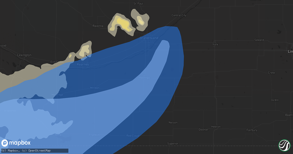
Hail Map in Hastings, NE on June 20, 2019
Get this storm
June 20 map
$229
one time, instant access
Download today. No call, no setup
Keep the $229
Bought the map and want the full workflow? Apply the entire $229 to a subscription within 7 days. None of it is wasted.
Every map, not just this one
This buys you this map. Subscription and you get every map we run, in the markets you choose from a few cities to whole states to nationwide. Plus real-time alerts the moment a storm fires.
Contact data
Name, contact info, occupancy, even credit band for addresses in the footprint. You go from where it hit to who to call.
Become the source they trust
Unlimited branding weather history reports on demand. You already have the documented answer ready for the property owner, and you are the one who showed up with it.
Property data and RoofTrace estimates
Pull up any address you have got, its value and the exact code rules for that jurisdiction, straight from One Click Code. Then RoofTrace estimates the squares, pitch, and roof value, priced the way you price.
Storm reports in Hastings, NE
Hastings, NE
| Date | Description |
|---|---|
| 06/20/20191:36 AM CDT | Corrects previous tstm wnd dmg report from 1 sse hastings. Reports from public of trees down. Courtesy of ntv. |
| 06/20/20191:30 AM CDT | Public report of several trees down at southern hills. Report from social media. |
| 06/20/20191:24 AM CDT | Powerline down across 12th street near saunders ave. |
| 06/20/20191:20 AM CDT | Estimated 6 inch diameter tree limbs are down near the fairgrounds. |
| 06/20/20191:18 AM CDT | A local report indicates 67 MPH wind near 4 ESE HASTINGS |
| 06/20/20191:15 AM CDT | A local report indicates 60 MPH wind near 2 SSE HASTINGS |
| 06/20/20191:15 AM CDT | Emergency manager reports large limbs down and some uprooted trees in hastings. Time estimated. |
All States Impacted by Hail Map on June 20, 2019
All Cities Impacted by Hail Map on June 20, 2019
- Fort Morgan, CO
- Effingham, KS
- Lancaster, KS
- Sac City, IA
- Lake View, IA
- Wood Lake, NE
- Eustis, NE
- Harrison, NE
- Moorhead, IA
- Runnells, IA
- Prairie City, IA
- Hayes Center, NE
- Wallace, NE
- Blackville, SC
- Diller, NE
- Odell, NE
- Blakely, GA
- Endicott, NE
- Steele City, NE
- Fairbury, NE
- Pampa, TX
- Redwood Falls, MN
- Akron, CO
- Odebolt, IA
- Schaller, IA
- Early, IA
- Leavenworth, KS
- Bonner Springs, KS
- Platte City, MO
- Basehor, KS
- Waldron, MO
- Kansas City, MO
- Kansas City, KS
- Modoc, SC
- Lincolnton, GA
- Plum Branch, SC
- Funk, NE
- Bertrand, NE
- Loomis, NE
- Elm Creek, NE
- Overton, NE
- Holdrege, NE
- Hardy, NE
- Bellvue, CO
- Loveland, CO
- Pierce, CO
- Nunn, CO
- Fort Collins, CO
- McCook, NE
- Bloomington, NE
- Lenora, KS
- Randolph, KS
- Grand Island, NE
- Dannebrog, NE
- Saint Libory, NE
- Carpenter, WY
- Pine Bluffs, WY
- Grover, CO
- Eatonton, GA
- Madison, GA
- Fitzgerald, GA
- Dana, IA
- Jefferson, IA
- Grand Junction, IA
- Arabi, GA
- Ashburn, GA
- Merriman, NE
- Cody, NE
- Clarkfield, MN
- Granite Falls, MN
- Cope, CO
- Padroni, CO
- Merino, CO
- Stoneham, CO
- Sterling, CO
- New Raymer, CO
- Shenandoah, IA
- Blue Earth, MN
- Strasburg, CO
- Harleyville, SC
- Holly Hill, SC
- Wood Lake, MN
- Echo, MN
- Boelus, NE
- Cairo, NE
- Burchard, NE
- Liberty, NE
- Hanover, KS
- Skidmore, MO
- Graham, MO
- Marion, SC
- Florence, SC
- Bennett, CO
- Onawa, IA
- Westboro, MO
- Northboro, IA
- Guyton, GA
- Rincon, GA
- Marsland, NE
- Dimock, SD
- Parkston, SD
- Mount Vernon, SD
- Ethan, SD
- Wilsonville, NE
- Hendley, NE
- Norton, KS
- Morgan, MN
- Springfield, MN
- Comfrey, MN
- Sleepy Eye, MN
- Truman, MN
- Saint James, MN
- Lewisville, MN
- Hanska, MN
- Clements, MN
- Madelia, MN
- Yuma, CO
- Idalia, CO
- Anton, CO
- Joes, CO
- Wray, CO
- Saint Francis, KS
- Kirk, CO
- Vernon, CO
- Imperial, NE
- Vermillion, KS
- Briggsdale, CO
- Republic, KS
- Byron, NE
- Superior, NE
- Webber, KS
- Abbeville, SC
- Bradley, SC
- McCormick, SC
- Calhoun Falls, SC
- Tignall, GA
- Elberton, GA
- Troy, SC
- Mount Carmel, SC
- Salley, SC
- Tifton, GA
- Red Cloud, NE
- Bladen, NE
- Inavale, NE
- Durham, NC
- Whitney, NE
- Crawford, NE
- Monticello, GA
- Juliette, GA
- Melrose, IA
- Albia, IA
- Denver, CO
- Aurora, CO
- Evans, GA
- Augusta, GA
- Page, NE
- Brunswick, NE
- Orchard, NE
- Royal, NE
- Winnetoon, NE
- Benkelman, NE
- Parks, NE
- Sycamore, GA
- Afton, TN
- Limestone, TN
- Chuckey, TN
- Stratton, NE
- Palisade, NE
- Trenton, NE
- Belview, MN
- Creedmoor, NC
- Knoxville, TN
- Greeleyville, SC
- Corsicana, TX
- Perry, IA
- Ogden, IA
- Dixon, NE
- Seneca, KS
- Sabetha, KS
- Oneida, KS
- Nelson, NE
- Saint George, KS
- Wamego, KS
- Scottsbluff, NE
- Alliance, NE
- Woodrow, CO
- Centralia, KS
- Craig, MO
- Fairfax, MO
- Colby, KS
- Karval, CO
- Lexington, NE
- Smithfield, NE
- Amherst, NE
- Kearney, NE
- Riverdale, NE
- Byers, CO
- Hanley Falls, MN
- Sloan, IA
- Hoxie, KS
- Selden, KS
- Stamford, NE
- Long Island, KS
- Deer Trail, CO
- Wetmore, KS
- Vona, CO
- Atchison, KS
- Nortonville, KS
- Arapahoe, NE
- Republican City, NE
- Winterset, IA
- Prole, IA
- Patterson, IA
- Saint Charles, IA
- Milford, NE
- Enigma, GA
- Saint Paul, NE
- Pamplico, SC
- Effingham, SC
- Ault, CO
- Bolivia, NC
- Cummings, KS
- Mankato, KS
- Glen Elder, KS
- Thomaston, GA
- Molena, GA
- Woodbury, GA
- Farnam, NE
- Lusk, WY
- Naponee, NE
- Delia, KS
- Mayetta, KS
- Bellevue, TX
- Appling, GA
- Clarks Hill, SC
- Oberlin, KS
- Herndon, KS
- Champion, NE
- Garrison, UT
- Washta, IA
- Quimby, IA
- Pawnee City, NE
- Axtell, KS
- Baileyville, KS
- Palmer, KS
- Aurora, KS
- Glasco, KS
- Clyde, KS
- Green, KS
- Concordia, KS
- Morganville, KS
- Miltonvale, KS
- Jamestown, KS
- Clay Center, KS
- Clifton, KS
- Leonardville, KS
- Scottsville, KY
- Cordova, SC
- Orangeburg, SC
- Neeses, SC
- Cope, SC
- Rushville, MO
- Correctionville, IA
- Seward, NE
- Chester, NE
- Hebron, NE
- Macon, NC
- Sellers, SC
- Mullins, SC
- Davenport, NE
- Oak, NE
- Fullerton, NE
- Palmer, NE
- Bishopville, SC
- Telford, TN
- Greeneville, TN
- Statesboro, GA
- Metter, GA
- Register, GA
- Ariton, AL
- Brundidge, AL
- Clio, AL
- Axtell, NE
- Minden, NE
- Blue Hill, NE
- Indianola, NE
- Friend, NE
- Cordova, NE
- Exeter, NE
- Formoso, KS
- Courtland, KS
- Jewell, KS
- Rembert, SC
- Preston, GA
- Parrott, GA
- Olsburg, KS
- Westmoreland, KS
- Haigler, NE
- Wauneta, NE
- Atwood, KS
- Shickley, NE
- Branchville, VA
- Boykins, VA
- Forsyth, GA
- Downs, KS
- Esbon, KS
- Chadron, NE
- Beaver City, NE
- Paton, IA
- Hubbell, NE
- Narka, KS
- Munden, KS
- Jennings, KS
- Churdan, IA
- Dearborn, MO
- Gower, MO
- Edgerton, MO
- Skipperville, AL
- Banks, AL
- Troy, AL
- Holbrook, NE
- Edison, NE
- Oxford, NE
- Cambridge, NE
- Rebecca, GA
- Chula, GA
- Barnes, KS
- Waterville, KS
- Blue Rapids, KS
- Onaga, KS
- Maitland, MO
- Maryville, MO
- Hawkinsville, GA
- Pineview, GA
- Unadilla, GA
- Streetman, TX
- Enders, NE
- Grovetown, GA
- North Augusta, SC
- Moorefield, NE
- Lebanon, NE
- Norcatur, KS
- Danbury, NE
- Vesta, MN
- Sanborn, MN
- Seaforth, MN
- Cottonwood, MN
- Lamberton, MN
- Winnebago, MN
- Milligan, NE
- Easton, MO
- Saint Joseph, MO
- Carlton, GA
- Repton, AL
- York, NE
- McCool Junction, NE
- Rexford, KS
- Burlington, CO
- Hemingford, NE
- Plattsburg, MO
- Mound City, MO
- Deshler, NE
- Alma, NE
- Littleton, NC
- Granada, MN
- Bushnell, NE
- Frankfort, KS
- Glendo, WY
- Columbia, NC
- Summerton, SC
- Pinewood, SC
- Stanberry, MO
- Creighton, NE
- Oneill, NE
- Auburn, IA
- Lindon, CO
- Oelrichs, SD
- Valentine, NE
- Ainsworth, NE
- Springview, NE
- Johnstown, NE
- Americus, GA
- Plains, GA
- Dawson, GA
- Kenesaw, NE
- Heartwell, NE
- Montgomery, AL
- Ramer, AL
- Forsyth, MT
- Orleans, NE
- Williston, SC
- Pickering, MO
- Burlington Junction, MO
- Sacred Heart, MN
- Tonganoxie, KS
- Glade, KS
- Phillipsburg, KS
- Mount Ayr, IA
- Valdosta, GA
- Arlington, GA
- Morgan, GA
- Torrington, WY
- Beloit, KS
- Manning, SC
- New Zion, SC
- Norway, SC
- Bird City, KS
- Hay Springs, NE
- Rushville, NE
- Kilgore, NE
- Crookston, NE
- Nenzel, NE
- Gordon, NE
- Ellsworth, NE
- Lakeside, NE
- Hoyt, KS
- Osceola, IA
- Haddam, KS
- Lyons, NE
- Rosalie, NE
- Eutawville, SC
- Crow Agency, MT
- Leary, GA
- Newton, GA
- Rowesville, SC
- Ravenna, NE
- Newville, AL
- Clopton, AL
- Branchville, SC
- Bowman, SC
- Home, KS
- Marysville, KS
- Smithville, GA
- Manhattan, KS
- Hillsborough, NC
- Springfield, SC
- Waco, NE
- Kirwin, KS
- Guide Rock, NE
- Saint Marys, KS
- Rossville, KS
- Elmore, MN
- Seibert, CO
- Logan, KS
- Abbeville, AL
- Shorterville, AL
- Eckley, CO
- Genoa, CO
- Rock Port, MO
- Ludell, KS
- Camden, SC
- Lebanon, KS
- Denmark, SC
- Bamberg, SC
- Galva, IA
- Ida Grove, IA
- Holstein, IA
- Falls City, NE
- Ocilla, GA
- Boone, IA
- Turney, MO
- Albany, GA
- Leesburg, GA
- Breda, IA
- Carroll, IA
- Bouton, IA
- Woodward, IA
- Caryville, TN
- Arcadia, IA
- Wood River, NE
- Netawaka, KS
- Whiting, KS
- Columbia, AL
- Whiting, IA
- Wymore, NE
- Worden, MT
- Watkins, CO
- McFall, MO
- Albany, MO
- Cuba, KS
- Agenda, KS
- Belleville, KS
- Everest, KS
- Randall, KS
- Norway, KS
- Scandia, KS
- Smithville, MO
- Trimble, MO
- Bartley, NE
- Elwood, NE
- De Kalb, MO
- Faucett, MO
- Agra, KS
- Glidden, IA
- Cuthbert, GA
- Farragut, IA
- Hamburg, IA
- Fairfield, TX
- Shelton, NE
- Rockville, NE
- Muscotah, KS
- Culbertson, NE
- Henderson, NE
- Hampton, NE
- Coin, IA
- Cross, SC
- Swan, IA
- Adel, IA
- Gaylord, KS
- Osborne, KS
- Flagler, CO
- Hazard, NE
- Tarkio, MO
- Guilford, MO
- Lawrence, NE
- Castalia, NC
- Louisburg, NC
- Maywood, NE
- Emmett, KS
- Curtis, NE
- Imogene, IA
- Emerson, NE
- Nehawka, NE
- Avoca, NE
- Jansen, NE
- Plymouth, NE
- Fort Leavenworth, KS
- Colquitt, GA
- Horton, KS
- Belgrade, NE
- Gibbon, NE
- Green Pond, SC
- Alton, KS
- Portis, KS
- Salem, NE
- Giltner, NE
- Aurora, NE
- Van Meter, IA
- Warwick, GA
- Amity, MO
- Commerce City, CO
- Maysville, MO
- Easton, KS
- Agency, MO
- Goff, KS
- Corning, KS
- Linn, KS
- Greenleaf, KS
- Pierson, IA
- Benedict, NE
- Weston, MO
- Edgar, NE
- Ong, NE
- Carleton, NE
- Ruskin, NE
- Sutton, NE
- Atlanta, NE
- Odessa, NE
- Pleasanton, NE
- Belvue, KS
- Groom, TX
- Rippey, IA
- Minburn, IA
- Lovilia, IA
- Moravia, IA
- Wellfleet, NE
- De Soto, IA
- De Soto, GA
- Cordele, GA
- Cobb, GA
- Oakfield, GA
- Myrtle Beach, SC
- Athens, TX
- Strang, NE
- McDonald, KS
- Hollenberg, KS
- Morrowville, KS
- Mahaska, KS
- Stromsburg, NE
- Polk, NE
- Conway, SC
- Asheboro, NC
- Fairmont, NE
- Lenox, IA
- Claxton, GA
- Poulan, GA
- Sylvester, GA
- Diagonal, IA
- Gresham, NE
- Sergeant Bluff, IA
- Sioux City, IA
- Salix, IA
- Bronson, IA
- Nashville, NC
- Waycross, GA
- Wathena, KS
- Elsie, NE
- Franklin, NE
- Riverton, NE
- Lohrville, IA
- Vance, SC
- Beaver, IA
- Moncure, NC
- Cozad, NE
- Lumber City, GA
- McRae Helena, GA
- Hazlehurst, GA
- Kimball, NE
- Bern, KS
- Dresden, KS
- Bogue, KS
- Plainview, NE
- Darlington, MO
- Jamestown, SC
- Lake City, IA
- Wall Lake, IA
- Iliff, CO
- Tyndall, SD
- Truro, IA
- Beaver Crossing, NE
- Dorchester, NE
- Bruning, NE
- Belvidere, NE
- Washington, KS
- Kingstree, SC
- Barnard, MO
- Bolckow, MO
- Warrenton, NC
- Albion, NE
- Reynolds, NE
- Pattonsburg, MO
- Graham, TX
- Olney, TX
- Bradshaw, NE
- Rosebud, MT
- Minneota, MN
- Wilcox, NE
- Clearmont, MO
- Forest City, MO
- Maxwell, NE
- Savannah, MO
- Amazonia, MO
- Andalusia, AL
- Madrid, IA
- Jefferson, SD
- Auburn, NE
- Otoe, NE
- Wray, GA
- Lathrop, MO
- Ty Ty, GA
- Verdigre, NE
- Cawker City, KS
- Hubbard, NE
- Waterbury, NE
- Dawson, IA
- Jamaica, IA
- Alcolu, SC
- Juniata, NE
- Laporte, CO
- Recluse, WY
- Weston, WY
- Gillette, WY
- Jonesborough, TN
- Columbia, SC
- Cayce, SC
- Kensington, KS
- Inland, NE
- Trumbull, NE
- Hildreth, NE
- Holstein, NE
- Athol, KS
- Harvard, NE
- Almena, KS
- Clay Center, NE
- Fairfield, NE
- Roseland, NE
- Alda, NE
- Prairie View, KS
- Ayr, NE
- Saronville, NE
- Campbell, NE
- Smith Center, KS
- Upland, NE
- Marquette, NE
- Deweese, NE
- Hastings, NE
- Doniphan, NE
- Central City, NE
- Chapman, NE
- Phillips, NE
- Glenvil, NE
- Blanch, NC
- Oxford, NC
- Ringgold, VA
- Alton, VA
- Providence, NC
- Roxboro, NC
- Milton, NC
- Pelham, NC
- Semora, NC
- Virgilina, VA
- Timberlake, NC
- Hurdle Mills, NC
- Mebane, NC
- Rougemont, NC
- Burlington, NC
- Prospect Hill, NC
- Yanceyville, NC
- Leasburg, NC
- New Ulm, MN
- Wanda, MN
- Darfur, MN
- Amboy, MN


