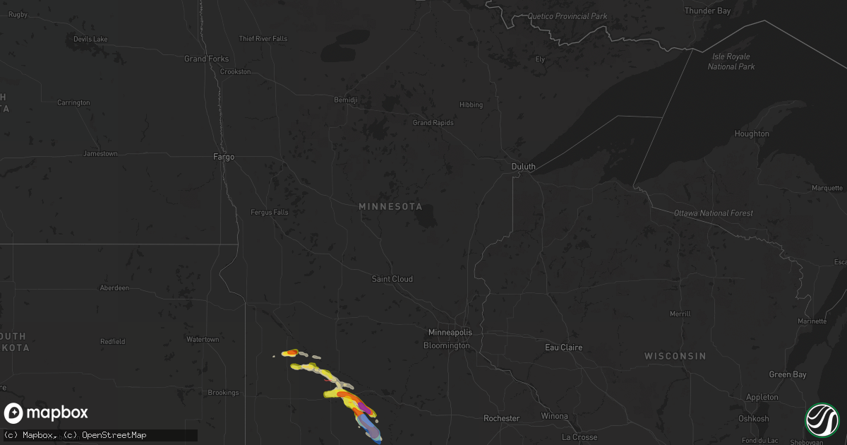
Hail Map in Minnesota on June 20, 2019
Get this storm
June 20 map
$229
one time, instant access
Download today. No call, no setup
Keep the $229
Bought the map and want the full workflow? Apply the entire $229 to a subscription within 7 days. None of it is wasted.
Every map, not just this one
This buys you this map. Subscription and you get every map we run, in the markets you choose from a few cities to whole states to nationwide. Plus real-time alerts the moment a storm fires.
Contact data
Name, contact info, occupancy, even credit band for addresses in the footprint. You go from where it hit to who to call.
Become the source they trust
Unlimited branding weather history reports on demand. You already have the documented answer ready for the property owner, and you are the one who showed up with it.
Property data and RoofTrace estimates
Pull up any address you have got, its value and the exact code rules for that jurisdiction, straight from One Click Code. Then RoofTrace estimates the squares, pitch, and roof value, priced the way you price.
Storm reports in Minnesota
Minnesota
| Date | Description |
|---|---|
| 06/20/20196:42 PM CDT | Watonwan county deputy reports tornado on the ground in godahl... Or 4 nw lasalle. |
| 06/20/20196:42 PM CDT | Corrects previous tornado report from godahl. Watonwan county deputy reported tornado lasted two minutes in open field in north central watonwan county... 0.5 se godahl |
| 06/20/20196:27 PM CDT | Tornado mostly moved across fields... But did hit a few groves of trees and one farmstead... Where minor damage occurred to a few outbuildings. Path length about 3 mile |
| 06/20/20195:30 PM CDT | Tree and some structural damage. Picture of tornado received. |
| 06/20/20195:20 PM CDT | Corrects previous tornado report from 6 nnw clements. Tree and some structural damage. Numerous pictures and videos of tornado. Path length 5.6 miles. |
| 06/20/20194:46 PM CDT | Photo sent via twitter. |
| 06/20/20194:40 PM CDT | A local report indicates 1.00 inch wind near ECHO |
| 06/20/20193:53 PM CDT | A local report indicates 1.75 inch wind near HAZEL RUN |
| 06/20/20193:43 AM CDT | At 843 PM CDT, a severe thunderstorm was located over Elmore, or 18 miles southeast of Fairmont, moving southeast at 20 mph. HAZARD...Ping pong ball size hail and 60 mph wind gusts. SOURCE...Radar indicated. IMPACT...People and animals outdoors will be injured. Expect hail damage to roofs, siding, windows, and vehicles. Expect wind damage to roofs, siding, and trees. Locations impacted include... Buffalo Center, Lakota, Rake and Ledyard. |
| 06/20/20192:14 AM CDT | At 713 PM CDT, a severe thunderstorm was located near St. James, or 20 miles north of Fairmont, moving southeast at 30 mph. HAZARD...Golf ball size hail and 60 mph wind gusts. SOURCE...Trained weather spotters. IMPACT...People and animals outdoors will be injured. Expect hail damage to roofs, siding, windows, and vehicles. Expect wind damage to roofs, siding, and trees. This severe thunderstorm will be near... Lewisville around 720 PM CDT. Truman around 735 PM CDT.Other locations impacted by this severe thunderstorm includeNorthrop, Echols and South Branch.This includes Interstate 90 between mile markers 98 and 100. |
| 06/20/20191:46 AM CDT | At 646 PM CDT, a severe thunderstorm was located 8 miles east of Comfrey, or 19 miles southwest of New Ulm, moving southeast at 30 mph. HAZARD...Ping pong ball size hail and 60 mph wind gusts. SOURCE...Radar indicated. IMPACT...People and animals outdoors will be injured. Expect hail damage to roofs, siding, windows, and vehicles. Expect wind damage to roofs, siding, and trees. This severe thunderstorm will be near... St. James around 705 PM CDT.Other locations impacted by this severe thunderstorm includeSveadahl, St James Airport and Echols. |
| 06/20/20191:29 AM CDT | At 629 PM CDT, a severe thunderstorm was located 7 miles west of Hanska, or 14 miles southwest of New Ulm, moving southeast at 25 mph. HAZARD...Tennis ball size hail and 60 mph wind gusts. SOURCE...Radar indicated. IMPACT...People and animals outdoors will be injured. Expect hail damage to roofs, siding, windows, and vehicles. Expect wind damage to roofs, siding, and trees. This severe thunderstorm will be near... Hanska around 645 PM CDT. Madelia around 705 PM CDT.Other locations impacted by this severe thunderstorm include LaSalle, St James Airport and Grogan. |
| 06/20/20191:10 AM CDT | At 609 PM CDT, a severe thunderstorm was located near Morgan, or 18 miles southeast of Redwood Falls, moving southeast at 20 mph. HAZARD...Golf ball size hail and 60 mph wind gusts. SOURCE...Radar indicated. IMPACT...People and animals outdoors will be injured. Expect hail damage to roofs, siding, windows, and vehicles. Expect wind damage to roofs, siding, and trees. This severe thunderstorm will remain over mainly rural areas of southeastern Redwood County. |
| 06/20/201912:55 AM CDT | At 555 PM CDT, a severe thunderstorm was located near Sleepy Eye, or 18 miles west of New Ulm, moving southeast at 20 mph. HAZARD...Golf ball size hail and 60 mph wind gusts. SOURCE...Radar indicated. IMPACT...People and animals outdoors will be injured. Expect hail damage to roofs, siding, windows, and vehicles. Expect wind damage to roofs, siding, and trees. This severe thunderstorm will be near... Sleepy Eye around 610 PM CDT.Other locations impacted by this severe thunderstorm include Cobden.This includes U.S. Highway 14 between mile markers 80 and 90. |
| 06/20/201912:24 AM CDT | At 523 PM CDT, a severe thunderstorm was located near Springfield, or 16 miles south of Redwood Falls, moving east at 20 mph. HAZARD...Ping pong ball size hail and 60 mph wind gusts. SOURCE...Radar indicated. IMPACT...People and animals outdoors will be injured. Expect hail damage to roofs, siding, windows, and vehicles. Expect wind damage to roofs, siding, and trees. This severe thunderstorm will be near... Morgan around 540 PM CDT. Sleepy Eye around 600 PM CDT.Other locations impacted by this severe thunderstorm include Cobden,Clements and Evan.This includes U.S. Highway 14 between mile markers 79 and 88. |
| 06/19/201911:45 PM CDT | At 445 PM CDT, a severe thunderstorm was located over Echo, or 14 miles west of Redwood Falls, moving east at 20 mph. HAZARD...Golf ball size hail and 60 mph wind gusts. SOURCE...Radar indicated. IMPACT...People and animals outdoors will be injured. Expect hail damage to roofs, siding, windows, and vehicles. Expect wind damage to roofs, siding, and trees. This severe thunderstorm will remain over mainly rural areas of north central Redwood, southeastern Yellow Medicine and west central Renville Counties, including the following locations... Delhi and Belview. |
| 06/19/201911:12 PM CDT | At 411 PM CDT, a severe thunderstorm was located near Cottonwood, or 13 miles northeast of Marshall, moving east at 20 mph. HAZARD...60 mph wind gusts and quarter size hail. SOURCE...Radar indicated. IMPACT...Hail damage to vehicles is expected. Expect wind damage to roofs, siding, and trees. This severe thunderstorm will be near... Echo around 445 PM CDT. |
| 06/19/201911:04 PM CDT | At 403 PM CDT, a severe thunderstorm was located over Cottonwood, or 12 miles northeast of Marshall, moving east at 20 mph. HAZARD...60 mph wind gusts and quarter size hail. SOURCE...Radar indicated. IMPACT...Hail damage to vehicles is expected. Expect wind damage to roofs, siding, and trees. This severe thunderstorm will remain over mainly rural areas of northeastern Lyon County near Cottonwood. |
| 06/19/201910:40 PM CDT | At 339 PM CDT, a severe thunderstorm was located near Clarkfield, or 13 miles south of Montevideo, moving east at 20 mph. HAZARD...60 mph wind gusts and half dollar size hail. SOURCE...Radar indicated. IMPACT...Hail damage to vehicles is expected. Expect wind damage to roofs, siding, and trees. This severe thunderstorm will be near... Hanley Falls around 355 PM CDT. Granite Falls around 410 PM CDT.Other locations impacted by this severe thunderstorm include GraniteFalls Airport, Spellman Lake and Hazel Run.This includes the following highways... U.S. Highway 212 between mile markers 42 and 52. U.S. Highway 59 between mile markers 89 and 100.This includes Prairies Edge Casino Resort. |
| 06/19/20197:45 PM CDT | A local report indicates 1.00 inch wind near TRUMAN |
| 06/19/20197:12 PM CDT | Corrects previous tstm wnd gst report from 4 e st. James. Nws damage survey determined this was a downburst... With divergent damage pattern fanning out. Hundreds of tr |
| 06/19/20197:09 PM CDT | A local report indicates 1.75 inch wind near ST. JAMES |
All States Impacted by Hail Map on June 20, 2019
Cities Impacted by Hail Map on June 20, 2019
- Fort Morgan, CO
- Effingham, KS
- Lancaster, KS
- Sac City, IA
- Lake View, IA
- Wood Lake, NE
- Eustis, NE
- Harrison, NE
- Moorhead, IA
- Runnells, IA
- Prairie City, IA
- Hayes Center, NE
- Wallace, NE
- Blackville, SC
- Diller, NE
- Odell, NE
- Blakely, GA
- Endicott, NE
- Steele City, NE
- Fairbury, NE
- Pampa, TX
- Redwood Falls, MN
- Akron, CO
- Odebolt, IA
- Schaller, IA
- Early, IA
- Leavenworth, KS
- Bonner Springs, KS
- Platte City, MO
- Basehor, KS
- Waldron, MO
- Kansas City, MO
- Kansas City, KS
- Modoc, SC
- Lincolnton, GA
- Plum Branch, SC
- Funk, NE
- Bertrand, NE
- Loomis, NE
- Elm Creek, NE
- Overton, NE
- Holdrege, NE
- Hardy, NE
- Bellvue, CO
- Loveland, CO
- Pierce, CO
- Nunn, CO
- Fort Collins, CO
- McCook, NE
- Bloomington, NE
- Lenora, KS
- Randolph, KS
- Grand Island, NE
- Dannebrog, NE
- Saint Libory, NE
- Carpenter, WY
- Pine Bluffs, WY
- Grover, CO
- Eatonton, GA
- Madison, GA
- Fitzgerald, GA
- Dana, IA
- Jefferson, IA
- Grand Junction, IA
- Arabi, GA
- Ashburn, GA
- Merriman, NE
- Cody, NE
- Clarkfield, MN
- Granite Falls, MN
- Cope, CO
- Padroni, CO
- Merino, CO
- Stoneham, CO
- Sterling, CO
- New Raymer, CO
- Shenandoah, IA
- Blue Earth, MN
- Strasburg, CO
- Harleyville, SC
- Holly Hill, SC
- Wood Lake, MN
- Echo, MN
- Boelus, NE
- Cairo, NE
- Burchard, NE
- Liberty, NE
- Hanover, KS
- Skidmore, MO
- Graham, MO
- Marion, SC
- Florence, SC
- Bennett, CO
- Onawa, IA
- Westboro, MO
- Northboro, IA
- Guyton, GA
- Rincon, GA
- Marsland, NE
- Dimock, SD
- Parkston, SD
- Mount Vernon, SD
- Ethan, SD
- Wilsonville, NE
- Hendley, NE
- Norton, KS
- Morgan, MN
- Springfield, MN
- Comfrey, MN
- Sleepy Eye, MN
- Truman, MN
- Saint James, MN
- Lewisville, MN
- Hanska, MN
- Clements, MN
- Madelia, MN
- Yuma, CO
- Idalia, CO
- Anton, CO
- Joes, CO
- Wray, CO
- Saint Francis, KS
- Kirk, CO
- Vernon, CO
- Imperial, NE
- Vermillion, KS
- Briggsdale, CO
- Republic, KS
- Byron, NE
- Superior, NE
- Webber, KS
- Abbeville, SC
- Bradley, SC
- McCormick, SC
- Calhoun Falls, SC
- Tignall, GA
- Elberton, GA
- Troy, SC
- Mount Carmel, SC
- Salley, SC
- Tifton, GA
- Red Cloud, NE
- Bladen, NE
- Inavale, NE
- Durham, NC
- Whitney, NE
- Crawford, NE
- Monticello, GA
- Juliette, GA
- Melrose, IA
- Albia, IA
- Denver, CO
- Aurora, CO
- Evans, GA
- Augusta, GA
- Page, NE
- Brunswick, NE
- Orchard, NE
- Royal, NE
- Winnetoon, NE
- Benkelman, NE
- Parks, NE
- Sycamore, GA
- Afton, TN
- Limestone, TN
- Chuckey, TN
- Stratton, NE
- Palisade, NE
- Trenton, NE
- Belview, MN
- Creedmoor, NC
- Knoxville, TN
- Greeleyville, SC
- Corsicana, TX
- Perry, IA
- Ogden, IA
- Dixon, NE
- Seneca, KS
- Sabetha, KS
- Oneida, KS
- Nelson, NE
- Saint George, KS
- Wamego, KS
- Scottsbluff, NE
- Alliance, NE
- Woodrow, CO
- Centralia, KS
- Craig, MO
- Fairfax, MO
- Colby, KS
- Karval, CO
- Lexington, NE
- Smithfield, NE
- Amherst, NE
- Kearney, NE
- Riverdale, NE
- Byers, CO
- Hanley Falls, MN
- Sloan, IA
- Hoxie, KS
- Selden, KS
- Stamford, NE
- Long Island, KS
- Deer Trail, CO
- Wetmore, KS
- Vona, CO
- Atchison, KS
- Nortonville, KS
- Arapahoe, NE
- Republican City, NE
- Winterset, IA
- Prole, IA
- Patterson, IA
- Saint Charles, IA
- Milford, NE
- Enigma, GA
- Saint Paul, NE
- Pamplico, SC
- Effingham, SC
- Ault, CO
- Bolivia, NC
- Cummings, KS
- Mankato, KS
- Glen Elder, KS
- Thomaston, GA
- Molena, GA
- Woodbury, GA
- Farnam, NE
- Lusk, WY
- Naponee, NE
- Delia, KS
- Mayetta, KS
- Bellevue, TX
- Appling, GA
- Clarks Hill, SC
- Oberlin, KS
- Herndon, KS
- Champion, NE
- Garrison, UT
- Washta, IA
- Quimby, IA
- Pawnee City, NE
- Axtell, KS
- Baileyville, KS
- Palmer, KS
- Aurora, KS
- Glasco, KS
- Clyde, KS
- Green, KS
- Concordia, KS
- Morganville, KS
- Miltonvale, KS
- Jamestown, KS
- Clay Center, KS
- Clifton, KS
- Leonardville, KS
- Scottsville, KY
- Cordova, SC
- Orangeburg, SC
- Neeses, SC
- Cope, SC
- Rushville, MO
- Correctionville, IA
- Seward, NE
- Chester, NE
- Hebron, NE
- Macon, NC
- Sellers, SC
- Mullins, SC
- Davenport, NE
- Oak, NE
- Fullerton, NE
- Palmer, NE
- Bishopville, SC
- Telford, TN
- Greeneville, TN
- Statesboro, GA
- Metter, GA
- Register, GA
- Ariton, AL
- Brundidge, AL
- Clio, AL
- Axtell, NE
- Minden, NE
- Blue Hill, NE
- Indianola, NE
- Friend, NE
- Cordova, NE
- Exeter, NE
- Formoso, KS
- Courtland, KS
- Jewell, KS
- Rembert, SC
- Preston, GA
- Parrott, GA
- Olsburg, KS
- Westmoreland, KS
- Haigler, NE
- Wauneta, NE
- Atwood, KS
- Shickley, NE
- Branchville, VA
- Boykins, VA
- Forsyth, GA
- Downs, KS
- Esbon, KS
- Chadron, NE
- Beaver City, NE
- Paton, IA
- Hubbell, NE
- Narka, KS
- Munden, KS
- Jennings, KS
- Churdan, IA
- Dearborn, MO
- Gower, MO
- Edgerton, MO
- Skipperville, AL
- Banks, AL
- Troy, AL
- Holbrook, NE
- Edison, NE
- Oxford, NE
- Cambridge, NE
- Rebecca, GA
- Chula, GA
- Barnes, KS
- Waterville, KS
- Blue Rapids, KS
- Onaga, KS
- Maitland, MO
- Maryville, MO
- Hawkinsville, GA
- Pineview, GA
- Unadilla, GA
- Streetman, TX
- Enders, NE
- Grovetown, GA
- North Augusta, SC
- Moorefield, NE
- Lebanon, NE
- Norcatur, KS
- Danbury, NE
- Vesta, MN
- Sanborn, MN
- Seaforth, MN
- Cottonwood, MN
- Lamberton, MN
- Winnebago, MN
- Milligan, NE
- Easton, MO
- Saint Joseph, MO
- Carlton, GA
- Repton, AL
- York, NE
- McCool Junction, NE
- Rexford, KS
- Burlington, CO
- Hemingford, NE
- Plattsburg, MO
- Mound City, MO
- Deshler, NE
- Alma, NE
- Littleton, NC
- Granada, MN
- Bushnell, NE
- Frankfort, KS
- Glendo, WY
- Columbia, NC
- Summerton, SC
- Pinewood, SC
- Stanberry, MO
- Creighton, NE
- Oneill, NE
- Auburn, IA
- Lindon, CO
- Oelrichs, SD
- Valentine, NE
- Ainsworth, NE
- Springview, NE
- Johnstown, NE
- Americus, GA
- Plains, GA
- Dawson, GA
- Kenesaw, NE
- Heartwell, NE
- Montgomery, AL
- Ramer, AL
- Forsyth, MT
- Orleans, NE
- Williston, SC
- Pickering, MO
- Burlington Junction, MO
- Sacred Heart, MN
- Tonganoxie, KS
- Glade, KS
- Phillipsburg, KS
- Mount Ayr, IA
- Valdosta, GA
- Arlington, GA
- Morgan, GA
- Torrington, WY
- Beloit, KS
- Manning, SC
- New Zion, SC
- Norway, SC
- Bird City, KS
- Hay Springs, NE
- Rushville, NE
- Kilgore, NE
- Crookston, NE
- Nenzel, NE
- Gordon, NE
- Ellsworth, NE
- Lakeside, NE
- Hoyt, KS
- Osceola, IA
- Haddam, KS
- Lyons, NE
- Rosalie, NE
- Eutawville, SC
- Crow Agency, MT
- Leary, GA
- Newton, GA
- Rowesville, SC
- Ravenna, NE
- Newville, AL
- Clopton, AL
- Branchville, SC
- Bowman, SC
- Home, KS
- Marysville, KS
- Smithville, GA
- Manhattan, KS
- Hillsborough, NC
- Springfield, SC
- Waco, NE
- Kirwin, KS
- Guide Rock, NE
- Saint Marys, KS
- Rossville, KS
- Elmore, MN
- Seibert, CO
- Logan, KS
- Abbeville, AL
- Shorterville, AL
- Eckley, CO
- Genoa, CO
- Rock Port, MO
- Ludell, KS
- Camden, SC
- Lebanon, KS
- Denmark, SC
- Bamberg, SC
- Galva, IA
- Ida Grove, IA
- Holstein, IA
- Falls City, NE
- Ocilla, GA
- Boone, IA
- Turney, MO
- Albany, GA
- Leesburg, GA
- Breda, IA
- Carroll, IA
- Bouton, IA
- Woodward, IA
- Caryville, TN
- Arcadia, IA
- Wood River, NE
- Netawaka, KS
- Whiting, KS
- Columbia, AL
- Whiting, IA
- Wymore, NE
- Worden, MT
- Watkins, CO
- McFall, MO
- Albany, MO
- Cuba, KS
- Agenda, KS
- Belleville, KS
- Everest, KS
- Randall, KS
- Norway, KS
- Scandia, KS
- Smithville, MO
- Trimble, MO
- Bartley, NE
- Elwood, NE
- De Kalb, MO
- Faucett, MO
- Agra, KS
- Glidden, IA
- Cuthbert, GA
- Farragut, IA
- Hamburg, IA
- Fairfield, TX
- Shelton, NE
- Rockville, NE
- Muscotah, KS
- Culbertson, NE
- Henderson, NE
- Hampton, NE
- Coin, IA
- Cross, SC
- Swan, IA
- Adel, IA
- Gaylord, KS
- Osborne, KS
- Flagler, CO
- Hazard, NE
- Tarkio, MO
- Guilford, MO
- Lawrence, NE
- Castalia, NC
- Louisburg, NC
- Maywood, NE
- Emmett, KS
- Curtis, NE
- Imogene, IA
- Emerson, NE
- Nehawka, NE
- Avoca, NE
- Jansen, NE
- Plymouth, NE
- Fort Leavenworth, KS
- Colquitt, GA
- Horton, KS
- Belgrade, NE
- Gibbon, NE
- Green Pond, SC
- Alton, KS
- Portis, KS
- Salem, NE
- Giltner, NE
- Aurora, NE
- Van Meter, IA
- Warwick, GA
- Amity, MO
- Commerce City, CO
- Maysville, MO
- Easton, KS
- Agency, MO
- Goff, KS
- Corning, KS
- Linn, KS
- Greenleaf, KS
- Pierson, IA
- Benedict, NE
- Weston, MO
- Edgar, NE
- Ong, NE
- Carleton, NE
- Ruskin, NE
- Sutton, NE
- Atlanta, NE
- Odessa, NE
- Pleasanton, NE
- Belvue, KS
- Groom, TX
- Rippey, IA
- Minburn, IA
- Lovilia, IA
- Moravia, IA
- Wellfleet, NE
- De Soto, IA
- De Soto, GA
- Cordele, GA
- Cobb, GA
- Oakfield, GA
- Myrtle Beach, SC
- Athens, TX
- Strang, NE
- McDonald, KS
- Hollenberg, KS
- Morrowville, KS
- Mahaska, KS
- Stromsburg, NE
- Polk, NE
- Conway, SC
- Asheboro, NC
- Fairmont, NE
- Lenox, IA
- Claxton, GA
- Poulan, GA
- Sylvester, GA
- Diagonal, IA
- Gresham, NE
- Sergeant Bluff, IA
- Sioux City, IA
- Salix, IA
- Bronson, IA
- Nashville, NC
- Waycross, GA
- Wathena, KS
- Elsie, NE
- Franklin, NE
- Riverton, NE
- Lohrville, IA
- Vance, SC
- Beaver, IA
- Moncure, NC
- Cozad, NE
- Lumber City, GA
- McRae Helena, GA
- Hazlehurst, GA
- Kimball, NE
- Bern, KS
- Dresden, KS
- Bogue, KS
- Plainview, NE
- Darlington, MO
- Jamestown, SC
- Lake City, IA
- Wall Lake, IA
- Iliff, CO
- Tyndall, SD
- Truro, IA
- Beaver Crossing, NE
- Dorchester, NE
- Bruning, NE
- Belvidere, NE
- Washington, KS
- Kingstree, SC
- Barnard, MO
- Bolckow, MO
- Warrenton, NC
- Albion, NE
- Reynolds, NE
- Pattonsburg, MO
- Graham, TX
- Olney, TX
- Bradshaw, NE
- Rosebud, MT
- Minneota, MN
- Wilcox, NE
- Clearmont, MO
- Forest City, MO
- Maxwell, NE
- Savannah, MO
- Amazonia, MO
- Andalusia, AL
- Madrid, IA
- Jefferson, SD
- Auburn, NE
- Otoe, NE
- Wray, GA
- Lathrop, MO
- Ty Ty, GA
- Verdigre, NE
- Cawker City, KS
- Hubbard, NE
- Waterbury, NE
- Dawson, IA
- Jamaica, IA
- Alcolu, SC
- Juniata, NE
- Laporte, CO
- Recluse, WY
- Weston, WY
- Gillette, WY
- Jonesborough, TN
- Columbia, SC
- Cayce, SC
- Kensington, KS
- Inland, NE
- Trumbull, NE
- Hildreth, NE
- Holstein, NE
- Athol, KS
- Harvard, NE
- Almena, KS
- Clay Center, NE
- Fairfield, NE
- Roseland, NE
- Alda, NE
- Prairie View, KS
- Ayr, NE
- Saronville, NE
- Campbell, NE
- Smith Center, KS
- Upland, NE
- Marquette, NE
- Deweese, NE
- Hastings, NE
- Doniphan, NE
- Central City, NE
- Chapman, NE
- Phillips, NE
- Glenvil, NE
- Blanch, NC
- Oxford, NC
- Ringgold, VA
- Alton, VA
- Providence, NC
- Roxboro, NC
- Milton, NC
- Pelham, NC
- Semora, NC
- Virgilina, VA
- Timberlake, NC
- Hurdle Mills, NC
- Mebane, NC
- Rougemont, NC
- Burlington, NC
- Prospect Hill, NC
- Yanceyville, NC
- Leasburg, NC
- New Ulm, MN
- Wanda, MN
- Darfur, MN
- Amboy, MN


