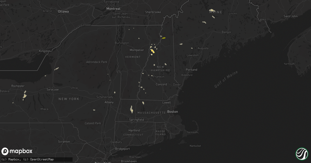
Hail Map in Vermont on June 19, 2024
Get this storm
June 19 map
$229
one time, instant access
Download today. No call, no setup
Keep the $229
Bought the map and want the full workflow? Apply the entire $229 to a subscription within 7 days. None of it is wasted.
Every map, not just this one
This buys you this map. Subscription and you get every map we run, in the markets you choose from a few cities to whole states to nationwide. Plus real-time alerts the moment a storm fires.
Contact data
Name, contact info, occupancy, even credit band for addresses in the footprint. You go from where it hit to who to call.
Become the source they trust
Unlimited branding weather history reports on demand. You already have the documented answer ready for the property owner, and you are the one who showed up with it.
Property data and RoofTrace estimates
Pull up any address you have got, its value and the exact code rules for that jurisdiction, straight from One Click Code. Then RoofTrace estimates the squares, pitch, and roof value, priced the way you price.
Storm reports in Vermont
Vermont
| Date | Description |
|---|---|
| 06/19/20245:05 PM CDT | Trees and powerlines down |
| 06/19/20243:13 PM CDT | Tree down on i-91 northbound just north of exit 14 |
| 06/19/20243:00 PM CDT | Multiple trees down on powerlines |
| 06/19/20241:36 PM CDT | Trees and powerlines down |
| 06/19/20241:24 PM CDT | Trees down on penny lane |
| 06/19/20241:19 PM CDT | Tree down in roadway with utility lines |
| 06/19/20241:10 PM CDT | Multiple trees down |
| 06/19/202412:10 PM CDT | Powerlines down on n wolcott rd |
| 06/19/202410:48 AM CDT | Observed 60.2 mph wind gust. Sheriff department reports trees down in franklin county. |
| 06/19/202410:44 AM CDT | Observed 60.2 mph wind gust. Sheriff department reports trees down in franklin county. |
| 06/19/202410:30 AM CDT | Trees down |
All States Impacted by Hail Map on June 19, 2024
Cities Impacted by Hail Map on June 19, 2024
- Guymon, OK
- Hardesty, OK
- Hooker, OK
- Balko, OK
- Goodwell, OK
- Stratford, TX
- Texhoma, OK
- Texhoma, TX
- Gruver, TX
- Manitou Beach, MI
- Addison, MI
- Brooklyn, MI
- Sheldon, VT
- Enosburg Falls, VT
- Richford, VT
- Hyde Park, VT
- Wolcott, VT
- Queensbury, NY
- Warrensburg, NY
- Rockford, OH
- Celina, OH
- Lisbon, NH
- Saint Johnsbury, VT
- Plainfield, NH
- Meriden, NH
- Valley Falls, NY
- Johnsonville, NY
- Willard, NM
- Alstead, NH
- Estancia, NM
- Brownville, ME
- Buskirk, NY
- Harmony, ME
- Alto, NM
- Bethel, ME
- Bryant Pond, ME
- Woodsville, NH
- North Haverhill, NH
- Springfield, NH
- Wilmot, NH
- Tijeras, NM
- Gilboa, NY
- Groveton, NH
- Edgewood, NM
- Bath, NH
- Guilford, ME
- Dover Foxcroft, ME
- Sugar Hill, NH
- Littleton, NH
- Bethlehem, NH
- North Stratford, NH
- Mescalero, NM
- Ruidoso, NM
- Moriarty, NM
- Stanley, NM
- Sandia Park, NM
- Rumney, NH
- Hebron, NH
- Cerrillos, NM
- Turner, ME
- Shelburne Falls, MA
- Ashfield, MA
- Santa Fe, NM
- Goshen, MA
- Williamsburg, MA
- Columbus, WI
- Center Sandwich, NH
- North Sandwich, NH
- South Tamworth, NH
- Las Vegas, NM
- Sapello, NM
- Cuervo, NM
- Warwick, MA
- Chesterfield, MA
- Fort Hancock, TX
- Cummington, MA
- Los Alamos, NM
- Orange, MA
- Glencoe, NM
- Easthampton, MA
- White Rock, NM
- Grand Rapids, OH
- Whitehouse, OH
- Waterville, OH
- Ruidoso Downs, NM
- Sierra Blanca, TX
- Vaughn, NM
- Anton Chico, NM
- Mountainair, NM
- Monclova, OH
- Sacramento, NM
- Rociada, NM
- Van Buren, OH
- Findlay, OH
- North Baltimore, OH
- McComb, OH
- Cygnet, OH
- Custar, OH
- El Paso, TX
- Chaparral, NM
- Portage, OH
- Wayne, OH
- Cloudcroft, NM
- Pierceton, IN
- Larwill, IN
- Warsaw, IN
- Adrian, MI
- Risingsun, OH
- Fostoria, OH
- Las Cruces, NM
- Bloomdale, OH
- Ocate, NM
- Tecumseh, MI
- North Webster, IN
- White Sands Missile Range, NM
- Leesburg, IN
- Watrous, NM
- Cromwell, IN
- Clinton, MI
- Springfield, VT
- Bellows Falls, VT
- Gilsum, NH
- Walpole, NH
- Marlborough, NH
- Keene, NH
- New Baltimore, MI
- Ann Arbor, MI
- Saline, MI
- New Haven, MI
- Livonia, MI
- Farmington, MI
- Southfield, MI
- Santa Rosa, NM
- Rudolph, OH
- Mount Morris, NY
- Allegany, NY
- Olean, NY
- Dansville, NY
- Magdalena, NM
- Canandaigua, NY
- Rushville, NY
- Socorro, NM
- Naples, NY
- Farmington, NY
- Shortsville, NY
- Concord, VT
- Gilman, VT
- Barnet, VT
- Cubero, NM
- Oswego, NY
- Laguna, NM
- Lacona, NY
- Lorraine, NY
- Mannsville, NY
- Montezuma, NM
- Bellville, TX
- Rockport, TX
- Dresser, WI
- Saint Croix Falls, WI


