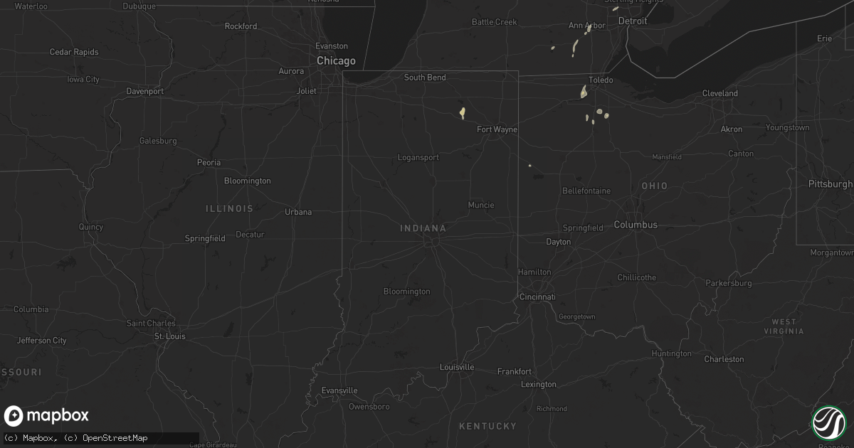
Hail Map in Indiana on June 19, 2024
Get this storm
June 19 map
$229
one time, instant access
Download today. No call, no setup
Keep the $229
Bought the map and want the full workflow? Apply the entire $229 to a subscription within 7 days. None of it is wasted.
Every map, not just this one
This buys you this map. Subscription and you get every map we run, in the markets you choose from a few cities to whole states to nationwide. Plus real-time alerts the moment a storm fires.
Contact data
Name, contact info, occupancy, even credit band for addresses in the footprint. You go from where it hit to who to call.
Become the source they trust
Unlimited branding weather history reports on demand. You already have the documented answer ready for the property owner, and you are the one who showed up with it.
Property data and RoofTrace estimates
Pull up any address you have got, its value and the exact code rules for that jurisdiction, straight from One Click Code. Then RoofTrace estimates the squares, pitch, and roof value, priced the way you price.
Storm reports in Indiana
Indiana
| Date | Description |
|---|---|
| 06/19/20246:45 PM CDT | Several trees down along backwater rd near webster lake. Time estimated from radar. |
| 06/19/20246:45 PM CDT | Tim estimated via radar. Photo on facebook showing a large tree limb down. Public report of several medium to large tree limbs down between cr 850 e and cr 925 e. |
| 06/19/20246:45 PM CDT | Several large tree limbs down at a home on backwater road. Time estimated via radar. |
| 06/19/20246:40 PM CDT | Large tree down near big barbee lake. Time estimated via radar. |
| 06/19/20246:40 PM CDT | Nws employee reports a swath of numerous small branches and a few larger branches 6+ inches in diameter down along sr-13 near kuhn lake. Time estimated by radar. |
All States Impacted by Hail Map on June 19, 2024
Cities Impacted by Hail Map on June 19, 2024
- Guymon, OK
- Hardesty, OK
- Hooker, OK
- Balko, OK
- Goodwell, OK
- Stratford, TX
- Texhoma, OK
- Texhoma, TX
- Gruver, TX
- Manitou Beach, MI
- Addison, MI
- Brooklyn, MI
- Sheldon, VT
- Enosburg Falls, VT
- Richford, VT
- Hyde Park, VT
- Wolcott, VT
- Queensbury, NY
- Warrensburg, NY
- Rockford, OH
- Celina, OH
- Lisbon, NH
- Saint Johnsbury, VT
- Plainfield, NH
- Meriden, NH
- Valley Falls, NY
- Johnsonville, NY
- Willard, NM
- Alstead, NH
- Estancia, NM
- Brownville, ME
- Buskirk, NY
- Harmony, ME
- Alto, NM
- Bethel, ME
- Bryant Pond, ME
- Woodsville, NH
- North Haverhill, NH
- Springfield, NH
- Wilmot, NH
- Tijeras, NM
- Gilboa, NY
- Groveton, NH
- Edgewood, NM
- Bath, NH
- Guilford, ME
- Dover Foxcroft, ME
- Sugar Hill, NH
- Littleton, NH
- Bethlehem, NH
- North Stratford, NH
- Mescalero, NM
- Ruidoso, NM
- Moriarty, NM
- Stanley, NM
- Sandia Park, NM
- Rumney, NH
- Hebron, NH
- Cerrillos, NM
- Turner, ME
- Shelburne Falls, MA
- Ashfield, MA
- Santa Fe, NM
- Goshen, MA
- Williamsburg, MA
- Columbus, WI
- Center Sandwich, NH
- North Sandwich, NH
- South Tamworth, NH
- Las Vegas, NM
- Sapello, NM
- Cuervo, NM
- Warwick, MA
- Chesterfield, MA
- Fort Hancock, TX
- Cummington, MA
- Los Alamos, NM
- Orange, MA
- Glencoe, NM
- Easthampton, MA
- White Rock, NM
- Grand Rapids, OH
- Whitehouse, OH
- Waterville, OH
- Ruidoso Downs, NM
- Sierra Blanca, TX
- Vaughn, NM
- Anton Chico, NM
- Mountainair, NM
- Monclova, OH
- Sacramento, NM
- Rociada, NM
- Van Buren, OH
- Findlay, OH
- North Baltimore, OH
- McComb, OH
- Cygnet, OH
- Custar, OH
- El Paso, TX
- Chaparral, NM
- Portage, OH
- Wayne, OH
- Cloudcroft, NM
- Pierceton, IN
- Larwill, IN
- Warsaw, IN
- Adrian, MI
- Risingsun, OH
- Fostoria, OH
- Las Cruces, NM
- Bloomdale, OH
- Ocate, NM
- Tecumseh, MI
- North Webster, IN
- White Sands Missile Range, NM
- Leesburg, IN
- Watrous, NM
- Cromwell, IN
- Clinton, MI
- Springfield, VT
- Bellows Falls, VT
- Gilsum, NH
- Walpole, NH
- Marlborough, NH
- Keene, NH
- New Baltimore, MI
- Ann Arbor, MI
- Saline, MI
- New Haven, MI
- Livonia, MI
- Farmington, MI
- Southfield, MI
- Santa Rosa, NM
- Rudolph, OH
- Mount Morris, NY
- Allegany, NY
- Olean, NY
- Dansville, NY
- Magdalena, NM
- Canandaigua, NY
- Rushville, NY
- Socorro, NM
- Naples, NY
- Farmington, NY
- Shortsville, NY
- Concord, VT
- Gilman, VT
- Barnet, VT
- Cubero, NM
- Oswego, NY
- Laguna, NM
- Lacona, NY
- Lorraine, NY
- Mannsville, NY
- Montezuma, NM
- Bellville, TX
- Rockport, TX
- Dresser, WI
- Saint Croix Falls, WI


