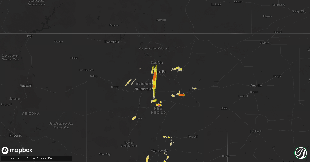
Hail Map on June 19, 2024
Get this storm
June 19 map
$229
one time, instant access
Download today. No call, no setup
Keep the $229
Bought the map and want the full workflow? Apply the entire $229 to a subscription within 7 days. None of it is wasted.
Every map, not just this one
This buys you this map. Subscription and you get every map we run, in the markets you choose from a few cities to whole states to nationwide. Plus real-time alerts the moment a storm fires.
Contact data
Name, contact info, occupancy, even credit band for addresses in the footprint. You go from where it hit to who to call.
Become the source they trust
Unlimited branding weather history reports on demand. You already have the documented answer ready for the property owner, and you are the one who showed up with it.
Property data and RoofTrace estimates
Pull up any address you have got, its value and the exact code rules for that jurisdiction, straight from One Click Code. Then RoofTrace estimates the squares, pitch, and roof value, priced the way you price.
States Impacted by Hail Map on June 19, 2024
Storm reports
Michigan
| Date | Description |
|---|---|
| 06/19/20246:54 PM CDT | Multiple large tree limbs down |
| 06/19/20246:35 PM CDT | Tree across the road at thompson st. And elmwood avenue. |
| 06/19/202412:50 AM CDT | Trees and power lines down. |
| 06/18/20249:20 PM CDT | Several reports of trees and wires down around shelby township. One tree blocking the entire road. |
| 06/18/20249:05 PM CDT | Tree down in the road near 14 mile and woodward. |
| 06/18/20249:02 PM CDT | Tree down blocking road near 14 mile and southfield |
| 06/18/20248:33 PM CDT | Oakland county emergency manager reports downed trees and power lines across farmington. |
| 06/18/20248:30 PM CDT | Trees down... Power outages... Lawn furniture blown around. |
| 06/18/20247:58 PM CDT | Tree down blocking roadway near 5 mile and curtis |
| 06/18/20247:57 PM CDT | Fire department reported several trees and powerlines down. |
| 06/18/20247:48 PM CDT | Tree limbs down near union lake and metro parkway |
| 06/18/20247:42 PM CDT | Tree down blocking roadway near clark and hogback |
| 06/18/20247:42 PM CDT | Tree down blocking roadway near plymouth and huron parkway. |
| 06/18/20247:40 PM CDT | Fire department reported several trees down around main st and clark. |
| 06/18/20247:35 PM CDT | Tree limbs down on 13 mile between groesbeck and gratiot. |
Massachusetts
| Date | Description |
|---|---|
| 06/19/20245:00 PM CDT | Law enforcement report tree down on royalston rd in templeton. Relayed by amateur radio. |
| 06/19/20245:00 PM CDT | Law enforcement report tree down on royalston rd in templeton. Relayed |
| 06/19/20245:00 PM CDT | Amateur radio operator reports tree down on wires on west street. |
| 06/19/20245:00 PM CDT | Law enforcement report tree down on royalston rd |
| 06/19/20244:51 PM CDT | A local report indicates 0 MPH wind near 2 NE Orange AP |
| 06/19/20244:51 PM CDT | Powerlines downed on brookside rd in athol. Relayed by amateur radio. |
| 06/19/20244:50 PM CDT | Tree down on house near gage rd in athol. Relayed by amateur radio. |
| 06/19/20244:50 PM CDT | First responders... Fire/law enforcement report trees and wires down on pleasant street and riverview avenue. Relayed by amateur radio. |
| 06/19/20244:47 PM CDT | Downed powerline wires on old chesterfield rd. Relayed by amateur radio. |
| 06/19/20244:47 PM CDT | Tree down blocking village hill rd in williamsburg. |
| 06/19/20244:28 PM CDT | Tree down on rt 116 at conway rd in ashfield. Time estimated by radar. Relayed by amateur radio. |
| 06/19/20244:22 PM CDT | Tree and wires downed in ashfield. Relayed by amateur radio. |
Maine
| Date | Description |
|---|---|
| 06/19/20243:40 PM CDT | Trees down on power lines and blocking roads in orneville. |
| 06/19/20243:35 PM CDT | Trees down on power lines and blocking roads in atkinson. |
| 06/19/20243:35 PM CDT | Trees down on power lines and blocking roads in milo. |
| 06/19/20243:21 PM CDT | Corrects previous tstm wnd dmg report from sebec. Trees down on power lines and blocking roads in sebec. |
| 06/19/20243:20 PM CDT | Trees down on power lines and blocking roads in brownville. |
| 06/19/20243:20 PM CDT | Trees down on power lines and blocking roads in dover-foxcroft. |
| 06/19/20243:17 PM CDT | Trees down on power lines and blocking roads in sebec. |
North Carolina
| Date | Description |
|---|---|
| 06/19/202410:20 AM CDT | This is a test. |
New Hampshire
| Date | Description |
|---|---|
| 06/19/20244:50 PM CDT | Large tree destroyed a shed. Numerous trees down across town. Time estimated via radar. |
| 06/19/20244:44 PM CDT | Trees and wires down on green mountain rd... Effingham. Time estimated from radar. |
| 06/19/20244:25 PM CDT | Social media photos of hail up to 1 inch in tamworth. Relayed via amateur radio. Time estimated via radar. |
| 06/19/20244:22 PM CDT | Tree down in the road blocking traffic with arching wires on jackson pond rd. Time estimated from radar. |
| 06/19/20243:35 PM CDT | Numerous trees and wires reported down throughout rumney... Nh. Tree reported leaning on home. Time estimated from radar. |
| 06/19/20242:45 PM CDT | Multiple trees and wires reported down in sugar hill... Nh. |
| 06/19/20242:40 PM CDT | Chaser reports multiple trees up to 6 inches in diameter down on route 302. Time estimated from radar. |
| 06/19/20242:33 PM CDT | Chaser reports period of ping pong sized hail. |
| 06/19/20242:30 PM CDT | Chaser reports trees down and some siding blown around near cornish. Time estimated by radar. |
| 06/19/20242:25 PM CDT | Hail observed on nh highway 10 in gilsum and posted on social media. Hail measured the size of quarters and accumulated on grassy areas. |
| 06/19/20242:24 PM CDT | Chaser reports multiple trees down along highway 120 near meriden. Time estimated from radar. |
| 06/19/20242:20 PM CDT | Multiple trees and wires reported down in lyman. |
| 06/19/20242:20 PM CDT | Large tree down on nh rte 10 south of gilsum. Partially blocking traffic near intersection of surry rd. Time estimated via radar. |
| 06/19/20242:20 PM CDT | Multiple trees and wires reported down in lyman... Nh. |
| 06/19/20242:20 PM CDT | Photo received via social media of a large tree down on powerlines blocking stage rd in plainfield. Time estimated via radar. |
| 06/19/20242:20 PM CDT | Multiple trees and wires down on 12a in plainfield. Time estimated from radar. |
| 06/19/20242:10 PM CDT | Observed trees and large branches down on nh hwy 12 |
| 06/19/20242:10 PM CDT | Several large trees downed on river rd south in walpole near ct river. Tree diameter ~10 inches. Time estimated via radar. |
| 06/19/20241:33 PM CDT | A local report indicates 1.25 inch wind near Stark |
| 06/19/20241:24 PM CDT | A couple trees down on hwy 110. |
| 06/19/20241:24 PM CDT | A couple trees down on hwy 110. |
Wisconsin
| Date | Description |
|---|---|
| 06/19/20243:02 PM CDT | Large tree branches down. |
New York
| Date | Description |
|---|---|
| 06/19/20246:48 PM CDT | Downed trees and wires reported on dow street and on barnersville rd in cobleskill |
| 06/19/20242:45 PM CDT | One oak tree snapped and blocking road on rt. 67. |
| 06/19/20241:28 PM CDT | Trees downed in the town of moreau |
| 06/19/20241:24 PM CDT | Trees downed in the town of wilton |
| 06/19/202412:28 PM CDT | Report of wires down. Time estimated by radar. |
| 06/19/202411:43 AM CDT | Trees and power lines down |
| 06/19/20249:06 AM CDT | Trees and power lines down |
| 06/19/20243:37 AM CDT | Tree fell down in roadway. |
| 06/19/20242:40 AM CDT | Tree down near porter center rd and balmer rd. Time estimated. |
| 06/18/202411:49 PM CDT | Tree down. |
| 06/18/202411:48 PM CDT | Tree down. |
| 06/18/202411:37 PM CDT | Tree fell blocking roadway. |
| 06/18/202411:12 PM CDT | Tree down in yard and partially blocking roadway. |
| 06/18/202411:08 PM CDT | Tree fell over roadway. |
| 06/18/202411:02 PM CDT | Corrects time of previous tstm wnd dmg report from 4 e victor. Tree down. Time estimated from radar. |
| 06/18/202410:56 PM CDT | Tree fell on trailer. |
| 06/18/202410:52 PM CDT | Delayed report... Time estimated based on radar. Tree down in farmington. |
| 06/18/202410:36 PM CDT | Tree down with wires hanging low. |
| 06/18/202410:30 PM CDT | Corrects time on previous tstm wnd dmg report from 3 wsw canandaigua. Tree down. Time estimated from radar. |
| 06/18/202410:18 PM CDT | Tree down in the town of allen. Time estimated from radar. |
| 06/18/202410:04 PM CDT | Tree down in the town of grove. Time estimated from radar. |
| 06/18/202410:00 PM CDT | Corrects previous time of tstm wnd dmg report from 3 sse south bristol. Tree fell blocking roadway. Time estimated from radar. |
| 06/18/20249:49 PM CDT | Corrects previous tstm wnd dmg report from 3 s groveland. Tree down. |
| 06/18/20249:45 PM CDT | Numerous trees down. |
Vermont
| Date | Description |
|---|---|
| 06/19/20245:05 PM CDT | Trees and powerlines down |
| 06/19/20243:13 PM CDT | Tree down on i-91 northbound just north of exit 14 |
| 06/19/20243:00 PM CDT | Multiple trees down on powerlines |
| 06/19/20241:36 PM CDT | Trees and powerlines down |
| 06/19/20241:24 PM CDT | Trees down on penny lane |
| 06/19/20241:19 PM CDT | Tree down in roadway with utility lines |
| 06/19/20241:10 PM CDT | Multiple trees down |
| 06/19/202412:10 PM CDT | Powerlines down on n wolcott rd |
| 06/19/202410:48 AM CDT | Observed 60.2 mph wind gust. Sheriff department reports trees down in franklin county. |
| 06/19/202410:44 AM CDT | Observed 60.2 mph wind gust. Sheriff department reports trees down in franklin county. |
| 06/19/202410:30 AM CDT | Trees down |
New Mexico
| Date | Description |
|---|---|
| 06/19/20246:45 PM CDT | Mesonet station wsm11 condron field |
| 06/19/20245:34 PM CDT | Mesonet station bmrn5 espanola 4 nw |
| 06/19/20244:54 PM CDT | Heavy rain. Road was trashed with debris from the flooding. |
| 06/19/20244:45 PM CDT | Mesonet station lanl4 los alamos 5 ssw |
| 06/19/20244:45 PM CDT | Mesonet station lanl5 los alamos 3 ese |
| 06/19/20244:20 PM CDT | Report forwarded by local media outlet. 50-60 mph winds observed along with quarter sized hail. |
| 06/19/20244:20 PM CDT | Report forwarded by local media outlet. 50-60 mph winds also observed. |
| 06/19/20244:20 PM CDT | Corrects previous non-tstm wnd gst report from 3 sse la bajada. Mesonet station nm011 i-25 at la bajada. |
| 06/19/20244:00 PM CDT | A local report indicates 1.25 inch wind near 1 NE Madrid |
| 06/19/20243:58 PM CDT | Half dollar size hail. Dented vehicles and broke house windows. Covered the ground 3 inches deep. |
| 06/19/20243:57 PM CDT | Corrects previous tstm wnd dmg report from 1 n edgewood. Power lines down in edgewood from severe storms as well as 5 power poles down. |
| 06/19/20243:57 PM CDT | Corrects previous tstm wnd dmg report from 1 n edgewood. Corrects previous tstm wnd dmg report from 1 n edgewood. Power lines down in edgewood from severe storms as wel |
| 06/19/20243:38 PM CDT | Mostly marble size but some up to 1 and half inches in diameter. |
| 06/19/20243:38 PM CDT | Mostly marble size but some larger. |
| 06/19/20243:30 PM CDT | Accumulations of quarter size hail and minor flooding at frost road and nm-344. |
| 06/19/20243:30 PM CDT | Villa madonna. |
| 06/19/20243:30 PM CDT | A local report indicates 1.00 inch wind near 3 NNE Edgewood |
| 06/19/20243:22 PM CDT | A local report indicates 60 MPH wind near 2 S Edgewood |
| 06/19/20243:00 PM CDT | Report from mping: 1-inch tree limbs broken; shingles blown off. |
| 06/19/20241:00 PM CDT | Mesonet station lcsn5 uscrn site at jornada usda headq. |
| 06/18/20247:26 PM CDT | Mesonet station lomn5 dripping springs raws. |
| 06/18/20247:03 PM CDT | Report from mping: quarter |
Texas
| Date | Description |
|---|---|
| 06/19/20246:48 PM CDT | Reports of significant roof damage and several trees down. Multiple reports of the public seeing the tornado. |
| 06/19/20246:23 PM CDT | 911 call: tree reported to be knocked down on trailer. |
| 06/19/20246:05 PM CDT | Social media report of tree damage. |
| 06/19/20245:25 PM CDT | Ef1 tornado occurred near bellville... Tx. Estimated peak winds at 100 mph with a path length of 1.90 miles and a width of 100 yards. |
Ohio
| Date | Description |
|---|---|
| 06/19/20246:50 PM CDT | Tree and wires downed. |
| 06/19/20246:37 PM CDT | Large limb across road. |
| 06/19/20246:30 PM CDT | Large limb across road. |
| 06/19/20246:29 PM CDT | Wires down. |
| 06/19/20246:20 PM CDT | Multiple trees downed onto bike path. |
| 06/19/20246:02 PM CDT | Pole downed with wires sparking. |
| 06/19/20245:33 PM CDT | Multiple large trees snapped with other large limbs downed. |
| 06/19/20245:26 PM CDT | Report from mping: downed tree limbs and/or power-lines. Time of damage estimated via radar. |
| 06/19/20245:15 PM CDT | Report from mping: downed tree limbs and/or power-lines. Time of damage estimated via radar. |
| 06/19/20245:10 PM CDT | Tree downed into house with partial structural collapse of the house. |
Indiana
| Date | Description |
|---|---|
| 06/19/20246:45 PM CDT | Tim estimated via radar. Photo on facebook showing a large tree limb down. Public report of several medium to large tree limbs down between cr 850 e and cr 925 e. |
| 06/19/20246:45 PM CDT | Several trees down along backwater rd near webster lake. Time estimated from radar. |
| 06/19/20246:45 PM CDT | Several large tree limbs down at a home on backwater road. Time estimated via radar. |
| 06/19/20246:40 PM CDT | Large tree down near big barbee lake. Time estimated via radar. |
| 06/19/20246:40 PM CDT | Nws employee reports a swath of numerous small branches and a few larger branches 6+ inches in diameter down along sr-13 near kuhn lake. Time estimated by radar. |
Cities Impacted by Hail Map on June 19, 2024
- Guymon, OK
- Hardesty, OK
- Hooker, OK
- Balko, OK
- Goodwell, OK
- Stratford, TX
- Texhoma, OK
- Texhoma, TX
- Gruver, TX
- Manitou Beach, MI
- Addison, MI
- Brooklyn, MI
- Sheldon, VT
- Enosburg Falls, VT
- Richford, VT
- Hyde Park, VT
- Wolcott, VT
- Queensbury, NY
- Warrensburg, NY
- Rockford, OH
- Celina, OH
- Lisbon, NH
- Saint Johnsbury, VT
- Plainfield, NH
- Meriden, NH
- Valley Falls, NY
- Johnsonville, NY
- Willard, NM
- Alstead, NH
- Estancia, NM
- Brownville, ME
- Buskirk, NY
- Harmony, ME
- Alto, NM
- Bethel, ME
- Bryant Pond, ME
- Woodsville, NH
- North Haverhill, NH
- Springfield, NH
- Wilmot, NH
- Tijeras, NM
- Gilboa, NY
- Groveton, NH
- Edgewood, NM
- Bath, NH
- Guilford, ME
- Dover Foxcroft, ME
- Sugar Hill, NH
- Littleton, NH
- Bethlehem, NH
- North Stratford, NH
- Mescalero, NM
- Ruidoso, NM
- Moriarty, NM
- Stanley, NM
- Sandia Park, NM
- Rumney, NH
- Hebron, NH
- Cerrillos, NM
- Turner, ME
- Shelburne Falls, MA
- Ashfield, MA
- Santa Fe, NM
- Goshen, MA
- Williamsburg, MA
- Columbus, WI
- Center Sandwich, NH
- North Sandwich, NH
- South Tamworth, NH
- Las Vegas, NM
- Sapello, NM
- Cuervo, NM
- Warwick, MA
- Chesterfield, MA
- Fort Hancock, TX
- Cummington, MA
- Los Alamos, NM
- Orange, MA
- Glencoe, NM
- Easthampton, MA
- White Rock, NM
- Grand Rapids, OH
- Whitehouse, OH
- Waterville, OH
- Ruidoso Downs, NM
- Sierra Blanca, TX
- Vaughn, NM
- Anton Chico, NM
- Mountainair, NM
- Monclova, OH
- Sacramento, NM
- Rociada, NM
- Van Buren, OH
- Findlay, OH
- North Baltimore, OH
- McComb, OH
- Cygnet, OH
- Custar, OH
- El Paso, TX
- Chaparral, NM
- Portage, OH
- Wayne, OH
- Cloudcroft, NM
- Pierceton, IN
- Larwill, IN
- Warsaw, IN
- Adrian, MI
- Risingsun, OH
- Fostoria, OH
- Las Cruces, NM
- Bloomdale, OH
- Ocate, NM
- Tecumseh, MI
- North Webster, IN
- White Sands Missile Range, NM
- Leesburg, IN
- Watrous, NM
- Cromwell, IN
- Clinton, MI
- Springfield, VT
- Bellows Falls, VT
- Gilsum, NH
- Walpole, NH
- Marlborough, NH
- Keene, NH
- New Baltimore, MI
- Ann Arbor, MI
- Saline, MI
- New Haven, MI
- Livonia, MI
- Farmington, MI
- Southfield, MI
- Santa Rosa, NM
- Rudolph, OH
- Mount Morris, NY
- Allegany, NY
- Olean, NY
- Dansville, NY
- Magdalena, NM
- Canandaigua, NY
- Rushville, NY
- Socorro, NM
- Naples, NY
- Farmington, NY
- Shortsville, NY
- Concord, VT
- Gilman, VT
- Barnet, VT
- Cubero, NM
- Oswego, NY
- Laguna, NM
- Lacona, NY
- Lorraine, NY
- Mannsville, NY
- Montezuma, NM
- Bellville, TX
- Rockport, TX
- Dresser, WI
- Saint Croix Falls, WI