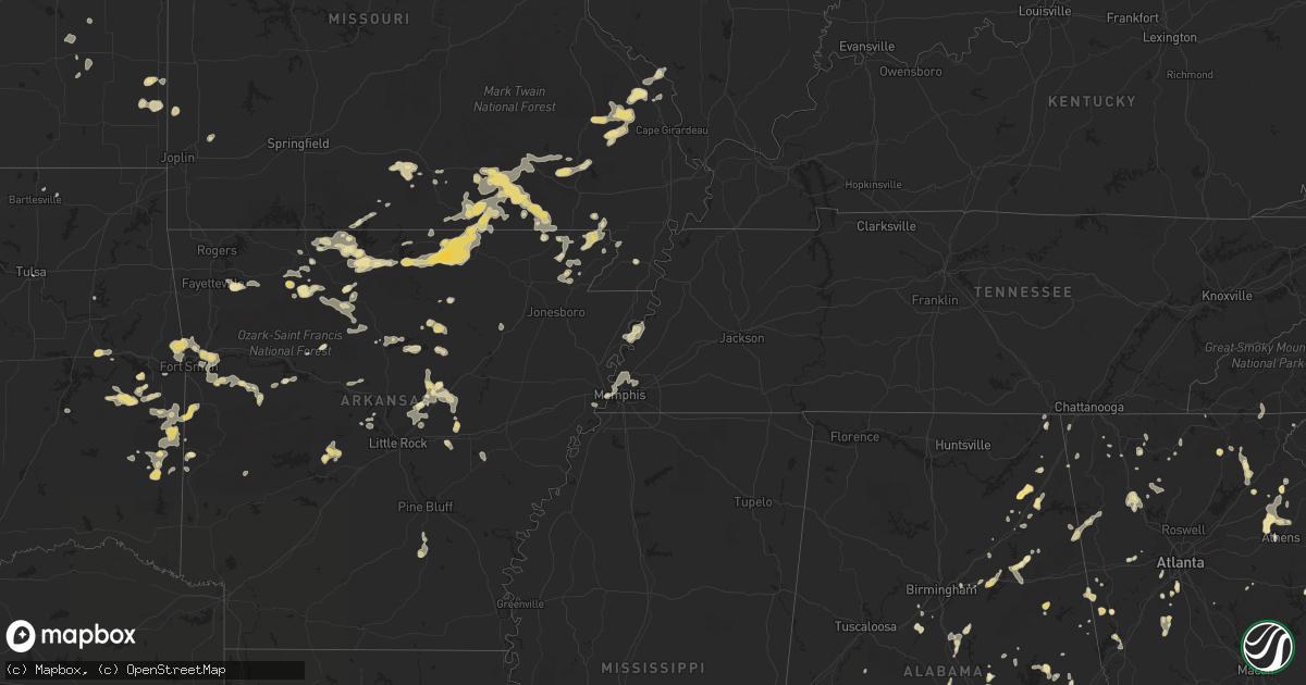
Hail Map in Arkansas on June 11, 2011
Get this storm
June 11 map
$229
one time, instant access
Download today. No call, no setup
Keep the $229
Bought the map and want the full workflow? Apply the entire $229 to a subscription within 7 days. None of it is wasted.
Every map, not just this one
This buys you this map. Subscription and you get every map we run, in the markets you choose from a few cities to whole states to nationwide. Plus real-time alerts the moment a storm fires.
Contact data
Name, contact info, occupancy, even credit band for addresses in the footprint. You go from where it hit to who to call.
Become the source they trust
Unlimited branding weather history reports on demand. You already have the documented answer ready for the property owner, and you are the one who showed up with it.
Property data and RoofTrace estimates
Pull up any address you have got, its value and the exact code rules for that jurisdiction, straight from One Click Code. Then RoofTrace estimates the squares, pitch, and roof value, priced the way you price.
Storm reports in Arkansas
Arkansas
| Date | Description |
|---|---|
| 06/11/20116:55 PM CDT | Quarter hail and gusty winds |
| 06/11/20115:35 PM CDT | Several large tree limbs and branches down |
| 06/11/20115:35 PM CDT | An outflow boundary produced winds strong enough to knock some shingles off of a roof of an apartment building. |
| 06/11/20114:40 PM CDT | Quarter sized hail along with a thunderstorm wind gust of estimated 60 mph. |
| 06/11/20114:24 PM CDT | Numerous quarter sized and slightly larger hail on county road 272 approx 2 miles west of piggott. |
All States Impacted by Hail Map on June 11, 2011
Cities Impacted by Hail Map on June 11, 2011
- Newell, SD
- Belle Fourche, SD
- Holcomb, KS
- Brooks, GA
- Dillwyn, VA
- Pamplin, VA
- Appomattox, VA
- Farmville, VA
- Prospect, VA
- Roundup, MT
- Crossville, AL
- Rock Hill, SC
- Edgemoor, SC
- Chester, SC
- Grover, CO
- Otis, CO
- Geary, OK
- Calumet, OK
- Akron, CO
- Camden, AL
- Broadus, MT
- Alzada, MT
- West Memphis, AR
- Scottsbluff, NE
- Mitchell, NE
- Morrill, NE
- Branson, CO
- Kim, CO
- Piedmont, AL
- Syracuse, KS
- Holly, CO
- Patton, MO
- Marble Hill, MO
- West Blocton, AL
- Helena, AL
- Montevallo, AL
- Brierfield, AL
- Red Level, AL
- Tuthill, SD
- Martin, SD
- Batesville, AR
- Darrouzett, TX
- Gage, OK
- Follett, TX
- Perryton, TX
- Laverne, OK
- Booker, TX
- Balko, OK
- Woodward, OK
- Sharon, OK
- Fort Supply, OK
- Shattuck, OK
- Fargo, OK
- Arnett, OK
- Buckingham, VA
- Gibsonville, NC
- Whitsett, NC
- Frazer, MT
- Beech Grove, AR
- Chesterfield, VA
- Midlothian, VA
- Briggsdale, CO
- Mindenmines, MO
- Liberal, MO
- Crawfordville, GA
- Union Point, GA
- Fremont, MO
- Monticello, KY
- Heathsville, VA
- Warner, OK
- Hardy, AR
- Mammoth Spring, AR
- Clayton, DE
- Smyrna, DE
- Yadkinville, NC
- Eads, CO
- Thayer, MO
- Couch, MO
- Rawlings, VA
- Pinckneyville, IL
- Tamaroa, IL
- Hennessey, OK
- Waukomis, OK
- McDaniels, KY
- Falls Of Rough, KY
- Leitchfield, KY
- Forgan, OK
- Roseland, VA
- Tyro, VA
- Cartersville, GA
- Beatrice, AL
- Lindale, GA
- Cave Spring, GA
- Cedartown, GA
- Rome, GA
- Hartford, AR
- Mansfield, AR
- Letohatchee, AL
- Fort Deposit, AL
- Williamsville, MO
- Wappapello, MO
- Greenville, MO
- Dadeville, AL
- Harrisburg, NE
- Zortman, MT
- Ennice, NC
- Glade Valley, NC
- Sparta, NC
- Beaver, OK
- Tyrone, OK
- Kismet, KS
- Lakin, KS
- Deerfield, KS
- Guymon, OK
- Rolla, KS
- Turpin, OK
- Plains, KS
- Hooker, OK
- Hugoton, KS
- Richfield, KS
- Gate, OK
- Goodwell, OK
- Ulysses, KS
- Meade, KS
- Liberal, KS
- La Junta, CO
- Centreville, MS
- Colonial Beach, VA
- King George, VA
- Autaugaville, AL
- Jones, AL
- Alpha, KY
- Albany, KY
- Camp Hill, AL
- Waverly, AL
- Hopkinsville, KY
- Gracey, KY
- Princeton, KY
- Cadiz, KY
- Cerulean, KY
- Wellington, AL
- Jacksonville, AL
- Atmore, AL
- Whitwell, TN
- Goodland, KS
- Lucedale, MS
- Davenport, OK
- Stroud, OK
- Chandler, OK
- Solgohachia, AR
- Morrilton, AR
- Byers, CO
- Deer Trail, CO
- Calera, AL
- Jemison, AL
- Tyner, KY
- Manchester, KY
- Sextons Creek, KY
- Hodgen, OK
- Wister, OK
- Heavener, OK
- Howe, OK
- Poteau, OK
- Limon, CO
- Matheson, CO
- Genoa, CO
- Monroeville, AL
- Repton, AL
- Iola, KS
- Humboldt, KS
- Bowdon, GA
- Greenville, AL
- Searcy, AR
- Romance, AR
- Eglin Afb, FL
- Bogalusa, LA
- Georgiana, AL
- Forest Home, AL
- Sharon Springs, KS
- Manakin Sabot, VA
- Henrico, VA
- Morse, LA
- Frohna, MO
- Jacob, IL
- Rockwood, IL
- Pine Apple, AL
- Harrison, AR
- Rocky Mount, VA
- Wirtz, VA
- Mays Landing, NJ
- Vineland, NJ
- Milmay, NJ
- Richland, NJ
- Hardinsburg, KY
- Havana, AR
- Ezel, KY
- Piggott, AR
- Holcomb, MO
- Reddick, FL
- Grinnell, KS
- Gove, KS
- Healy, KS
- Millers Creek, NC
- Jefferson, NC
- South Williamson, KY
- Belfry, KY
- Canada, KY
- Sidney, KY
- Forest Hills, KY
- Huddy, KY
- Hardy, KY
- Amelia Court House, VA
- Powhatan, VA
- Chadron, NE
- Kit Carson, CO
- Burlington, CO
- Bethune, CO
- Woodruff, SC
- Marquand, MO
- Nicholson, GA
- Hull, GA
- Manchester, MD
- Upperco, MD
- Hampstead, MD
- Westminster, MD
- Parkton, MD
- Fayetteville, GA
- Tyrone, GA
- Coldwater, KS
- Buffalo, OK
- Protection, KS
- Crestview, FL
- Chappells, SC
- Cross Hill, SC
- Wray, CO
- El Reno, OK
- Okarche, OK
- Stevenson, AL
- Whitesville, KY
- Dinwiddie, VA
- Petersburg, VA
- Columbus, GA
- Fort Benning, GA
- Phenix City, AL
- Gladstone, VA
- Wingina, VA
- Magazine, AR
- Booneville, AR
- Paris, AR
- Enid, OK
- Ringwood, OK
- Carrier, OK
- Meno, OK
- Lahoma, OK
- Keota, OK
- Mccurtain, OK
- Bokoshe, OK
- Manchester, OK
- Corning, AR
- Pollard, AR
- Galax, VA
- Woodlawn, VA
- Whatley, AL
- Franklin, AL
- Jefferson, GA
- Athens, GA
- Yellville, AR
- Georgetown, DE
- Pisgah, AL
- Henagar, AL
- Boones Mill, VA
- Richmond, VA
- Paris, TN
- Glenallen, MO
- Lamar, CO
- Wrightsville, PA
- York, PA
- Marietta, PA
- Bainbridge, PA
- Maytown, PA
- Elizabethtown, PA
- Saint Joe, AR
- Sardis, AL
- Smiths Grove, KY
- Scottsville, KY
- Glasgow, KY
- Bowling Green, KY
- Sparks, OK
- Clermont, GA
- Lula, GA
- Cleveland, GA
- Kannapolis, NC
- Rockwell, NC
- China Grove, NC
- Collinsville, AL
- Memphis, TN
- Vergennes, IL
- Murphysboro, IL
- Ava, IL
- Medford, OK
- Lamont, OK
- White Plains, GA
- Greensboro, GA
- Moseley, VA
- Gravel Switch, KY
- Danville, KY
- Parksville, KY
- Hatfield, AR
- Pike Road, AL
- Mathews, AL
- Minatare, NE
- Saint Francis, KS
- McKee, KY
- Reidsville, NC
- Siler City, NC
- Pittsboro, NC
- Carmen, OK
- Waynoka, OK
- Aline, OK
- Eddyville, IL
- Harrisburg, IL
- Roxboro, NC
- Lodge Grass, MT
- Wetumpka, AL
- Clayton, GA
- Hayesville, NC
- Palmyra, PA
- Grantville, PA
- Hershey, PA
- Hummelstown, PA
- Belspring, VA
- Dublin, VA
- Radford, VA
- Roaring River, NC
- North Wilkesboro, NC
- Bigelow, AR
- Roland, AR
- Theodosia, MO
- Bridgeport, AL
- Erwinville, LA
- Lakeland, LA
- Oscar, LA
- Port Allen, LA
- Thomasville, AL
- Grove Hill, AL
- Hulett, WY
- Dahlonega, GA
- Vanzant, MO
- Jasper, AR
- Jasper, GA
- Fairmount, GA
- Ranger, GA
- Glade Hill, VA
- Cayuta, NY
- Erin, NY
- Van Etten, NY
- Forkland, AL
- Quitman, AR
- Drasco, AR
- Higden, AR
- Heber Springs, AR
- Alma, AR
- Muldrow, OK
- Lavaca, AR
- Roland, OK
- Blue Mountain, AR
- Fort Smith, AR
- Rudy, AR
- Chester, AR
- Cedarville, AR
- Van Buren, AR
- Ratcliff, AR
- Uniontown, AR
- Branch, AR
- Charleston, AR
- Greensboro, NC
- Norwood, NC
- Millington, TN
- Franklin, GA
- Kyle, SD
- Pine Ridge, SD
- Spearman, TX
- Morriston, FL
- Monroe, VA
- Bison, OK
- Makanda, IL
- Winona, MO
- Doniphan, MO
- Van Buren, MO
- Birch Tree, MO
- Alton, MO
- Qulin, MO
- Stony Point, NC
- Statesville, NC
- Rainsville, AL
- Lenoir, NC
- Taylorsville, NC
- Concord, NC
- Yuma, CO
- Fredericksburg, VA
- Rappahannock Academy, VA
- Stafford, VA
- Ashville, AL
- Carpenter, WY
- Hazelton, KS
- Waldron, KS
- Newark, NY
- Phelps, NY
- Clifton Springs, NY
- Tuskegee, AL
- Campton, KY
- Wellington, KY
- Kiowa, CO
- Elbert, CO
- Baker, LA
- Baton Rouge, LA
- Zachary, LA
- Scenic, SD
- Wanblee, SD
- Interior, SD
- Taloga, OK
- Reynolds Station, KY
- Fordsville, KY
- Semora, NC
- Leasburg, NC
- Carson, VA
- Rector, AR
- Cabot, AR
- Ripley, OK
- Yale, OK
- Stillwater, OK
- Merino, CO
- Sterling, CO
- Fancy Gap, VA
- Peel, AR
- Sylvania, AL
- Fort Payne, AL
- Dover, TN
- Wilmer, AL
- Eight Mile, AL
- Semmes, AL
- Mobile, AL
- Franklin, KS
- Arma, KS
- Pittsburg, KS
- Girard, KS
- Mutual, OK
- Mooreland, OK
- Vici, OK
- Concord, AR
- Jackson Springs, NC
- West End, NC
- Aberdeen, NC
- Opelika, AL
- Pelsor, AR
- Torrington, WY
- Veteran, WY
- Yoder, WY
- Kinta, OK
- Nellysford, VA
- Dodson, MT
- Agate, CO
- Lacombe, LA
- Abita Springs, LA
- Angie, LA
- Bush, LA
- Covesville, VA
- Springfield, CO
- Seminole, OK
- Gainesville, FL
- Red Oak, OK
- Koshkonong, MO
- Frontenac, KS
- Atlanta, GA
- Oxford, AR
- Wiseman, AR
- Ash Flat, AR
- Horseshoe Bend, AR
- Camp, AR
- Salem, AR
- Glencoe, AR
- Boyes, MT
- Nanjemoy, MD
- Lineville, AL
- Delta, AL
- Tylertown, MS
- Franklinton, LA
- Sandy Hook, MS
- Lapine, AL
- Highland Home, AL
- Freeman, VA
- Lawrenceville, VA
- Dolphin, VA
- Alberta, VA
- Brodnax, VA
- Tuckerman, AR
- Drummond, OK
- Douglas, OK
- Fairmont, OK
- Eagle Springs, NC
- Carthage, NC
- Gadsden, AL
- Ramer, AL
- Montgomery, AL
- Golconda, IL
- Johnson City, TN
- Piney Flats, TN
- Hamptonville, NC
- Malta, MT
- Parthenon, AR
- Oglala, SD
- Farrar, MO
- Perryville, MO
- Pawnee, OK
- Morrison, OK
- Birney, MT
- Lame Deer, MT
- Cherokee, OK
- Wewoka, OK
- Holdenville, OK
- Sasakwa, OK
- Sedgewickville, MO
- Friedheim, MO
- Jonesville, LA
- Mentone, AL
- Menlo, GA
- Millry, AL
- Chatom, AL
- Hickory, NC
- Custer, SD
- Commerce, GA
- Carnesville, GA
- Finley, TN
- Sandgap, KY
- Lavonia, GA
- Lower Peach Tree, AL
- Newton, NC
- Maiden, NC
- Vredenburgh, AL
- Coy, AL
- Range, AL
- Brewton, AL
- Castleberry, AL
- Frisco City, AL
- Columbia, PA
- Emigsville, PA
- Manchester, PA
- York Haven, PA
- Mount Joy, PA
- Mount Wolf, PA
- Dolph, AR
- Naylor, MO
- Ellsinore, MO
- Mountain Home, AR
- Mill Spring, MO
- Ellington, MO
- Oxly, MO
- Cherokee Village, AR
- Bexar, AR
- Calico Rock, AR
- Pineville, AR
- Elizabeth, AR
- Myrtle, MO
- Wideman, AR
- Ravenden, AR
- Success, AR
- Maynard, AR
- Norfork, AR
- Piedmont, MO
- Big Sandy, TN
- Honoraville, AL
- Geraldine, AL
- Dawson, AL
- Ames, OK
- Mountain View, AR
- Locust Grove, AR
- Roopville, GA
- Graham, AL
- Ranburne, AL
- Bath, NY
- Elkins, AR
- Wesley, AR
- Hindsville, AR
- Senoia, GA
- Kingfisher, OK
- Campbell, MO
- Greenville, SC
- Bronston, KY
- Salisbury, NC
- Du Quoin, IL
- Breaux Bridge, LA
- Chester, OK
- Badin, NC
- Albemarle, NC
- New London, NC
- Paden, OK
- Keysville, VA
- Drakes Branch, VA
- Meherrin, VA
- Chase City, VA
- Victoria, VA
- Carlisle, AR
- Hazen, AR
- Hudson, NC
- Watonga, OK
- Fay, OK
- Thomas, OK
- Glenville, PA
- Hanover, PA
- Billingsley, AL
- Selma, AL
- Hardy, VA
- Roanoke, VA
- Kimball, NE
- Sandston, VA
- Hartwell, GA
- Custer, MT
- Musselshell, MT
- Holyoke, CO
- Pine Bluffs, WY
- Bushnell, NE
- Warfield, VA
- Stuart, VA
- Union Grove, NC
- Ronda, NC
- Brusett, MT
- Tonkawa, OK
- Welda, KS
- Knobel, AR
- Delaplaine, AR
- Peach Orchard, AR
- Marland, OK
- Red Rock, OK
- Wiley, CO
- Smithville, OK
- Montebello, VA
- Lovingston, VA
- Arrington, VA
- Kadoka, SD
- Mena, AR
- Perry, OK
- Rison, AR
- Mount Gilead, NC
- Canton, OK
- Johnson, KS
- Lamar, AR
- Dover, AR
- Columbiana, AL
- Kellyton, AL
- Altoona, AL
- Boaz, AL
- Attalla, AL
- Hot Springs Village, AR
- Oelrichs, SD
- Newmanstown, PA
- Schaefferstown, PA
- Lebanon, PA
- Ono, PA
- Myerstown, PA
- Jonestown, PA
- Harrisburg, PA
- Annville, PA
- Washington, GA
- Tignall, GA
- Piedmont, SC
- Easley, SC
- Huntsville, AR
- Ralston, OK
- Colby, KS
- Monument, KS
- Hurtsboro, AL
- Nashua, MT
- Stuarts Draft, VA
- Dundee, NY
- Penn Yan, NY
- Pulteney, NY
- Hammondsport, NY
- Branchport, NY
- Prattsburgh, NY
- Keuka Park, NY
- Roe, AR
- De Valls Bluff, AR
- Amorita, OK
- McRae, AR
- Garner, AR
- Beebe, AR
- Idalia, CO
- Dalton, GA
- Resaca, GA
- Minotola, NJ
- Buena, NJ
- Landisville, NJ
- Gurley, NE
- Lodgepole, NE
- Crozet, VA
- Charlottesville, VA
- Jonesboro, GA
- Riverdale, GA
- Webbers Falls, OK
- Checotah, OK
- Merriman, NE
- Flippin, AR
- Lead Hill, AR
- Callao, VA
- Lottsburg, VA
- Kinsale, VA
- Scotland, MD
- Paragould, AR
- Steele, AL
- Omega, OK
- Marshall, OK
- Clanton, AL
- Sparks Glencoe, MD
- Reisterstown, MD
- Titus, AL
- Chatsworth, GA
- Blacksburg, SC
- Bragg City, MO
- Century, FL
- McDavid, FL
- Albin, WY
- Roxie, MS
- Natchez, MS
- Elkin, NC
- Harrisburg, NC
- Charlotte, NC
- Alvaton, KY
- Pond Creek, OK
- Nash, OK
- Frankford, DE
- Willards, MD
- Kenbridge, VA
- Blackstone, VA
- Dundas, VA
- Tribune, KS
- Angora, NE
- Bridgeport, NE
- Arnaudville, LA
- Eldorado, IL
- Kiowa, KS
- Kingston, GA
- Adairsville, GA
- Alachua, FL
- Harold, KY
- Osceola, AR
- Anniston, AL
- Alexandria, AL
- Ohatchee, AL
- Leeds, AL
- Mechanicsville, VA
- Guthrie, OK
- Leoti, KS
- Scott City, KS
- Dickinson, AL
- Beattyville, KY
- Eufaula, AL
- Carthage, MO
- Avilla, MO
- Golden City, MO
- Hollywood, MD
- Watauga, TN
- Worden, MT
- Fairfax, OK
- Hominy, OK
- Staunton, VA
- Fishersville, VA
- Waynesboro, VA
- McLeansville, NC
- Fredericktown, MO
- Zalma, MO
- Fairfield Bay, AR
- Edgemont, AR
- Ponca City, OK
- Billings, OK
- Ellsworth, NE
- Ashland, VA
- Bogart, GA
- Gay, GA
- Napoleonville, LA
- Granada, CO
- Freedom, OK
- Elizabeth, CO
- Union Hall, VA
- Penhook, VA
- Troy, NC
- Boley, OK
- Kremlin, OK
- Ellis, KS
- Caneyville, KY
- Millwood, KY
- Vesuvius, VA
- Prim, AR
- Shady Point, OK
- Seiling, OK
- Gillsville, GA
- Cheyenne Wells, CO
- Warsaw, VA
- Rapid City, SD
- Hermosa, SD
- Honobia, OK
- Cornelia, GA
- Sautee Nacoochee, GA
- Alto, GA
- Helen, GA
- Flat Rock, AL
- New Blaine, AR
- Delaware, AR
- Putnam, OK
- Hinton, OK
- Greenfield, OK
- Oakwood, OK
- Custer City, OK
- Bassett, VA
- Patrick Springs, VA
- Douglasville, GA
- Dallas, GA
- Villa Rica, GA
- Laurel Springs, NC
- Seale, AL
- Arlington, KY
- Bardwell, KY
- Stanford, KY
- Crab Orchard, KY
- Federalsburg, MD
- Bridgeville, DE
- Whitesboro, OK
- Dighton, KS
- Oakley, KS
- Whitmire, SC
- Dewey, OK
- Mount Airy, NC
- Clinton, AR
- Jerusalem, AR
- Leslie, AR
- Dennard, AR
- Laurel Fork, VA
- Hillsville, VA
- Raton, NM
- Springer, NM
- Gold Hill, NC
- Mount Pleasant, NC
- Wakita, OK
- Isabella, MO
- Pell City, AL
- Walsh, CO
- Seven Valleys, PA
- Colonial Heights, VA
- Chester, VA
- Aurora, CO
- Watkins Glen, NY
- Rock Stream, NY
- Chanute, KS
- Farlington, KS
- Fort Scott, KS
- Mulhall, OK
- Notasulga, AL
- Uriah, AL
- Glen Rock, PA
- Marble Falls, AR
- Compton, AR
- Alpena, AR
- Green Forest, AR
- Shelby, AL
- Carrollton, GA
- Statham, GA
- Traphill, NC
- Deatsville, AL
- Free Union, VA
- Mansfield, GA
- Newborn, GA
- Rock Spring, GA
- Rayle, GA
- Rockford, AL
- Glassboro, NJ
- Swedesboro, NJ
- Franklinville, NJ
- Clayton, NJ
- Monroeville, NJ
- Sewell, NJ
- Mickleton, NJ
- Mullica Hill, NJ
- Greensboro, AL
- Moundville, AL
- Forsyth, MT
- Homer, GA
- Maysville, GA
- Ponca, AR
- York New Salem, PA
- Thomasville, PA
- Spring Grove, PA
- Dallastown, PA
- Concord, VA
- Pritchett, CO
- Geismar, LA
- Gonzales, LA
- Prairieville, LA
- Cropwell, AL
- Riverside, AL
- Colbert, GA
- Lewisburg, KY
- Cope, CO
- Cana, VA
- Ararat, VA
- Greenville, VA
- Raphine, VA
- Saint Inigoes, MD
- Seaford, DE
- Ferrum, VA
- Lancaster, KY
- Leesburg, AL
- Marquette, NE
- Gering, NE
- Austin, AR
- Christiansburg, VA
- Piney River, VA
- Larned, KS
- Kinsley, KS
- Garfield, KS
- Lewis, KS
- Newburg, MD
- Faulkner, MD
- Bel Alton, MD
- Carencro, LA
- Mayflower, AR
- Upper Marlboro, MD
- Huntingtown, MD
- Owings, MD
- Sunderland, MD
- Brandywine, MD
- Dunkirk, MD
- Berlin, MD
- Whaleyville, MD
- Winnett, MT
- Monterey, LA
- Decker, MT
- Cushing, OK
- Depew, OK
- Nardin, OK
- Deer Creek, OK
- Stewart, TN
- Minter, AL
- Altenburg, MO
- Oak Ridge, MO
- Jackson, MO
- Worthington, IN
- Richton, MS
- Ovett, MS
- Burlington, NC
- Mebane, NC
- Saluda, NC
- Alliance, NE
- Harrison, NE
- Wasola, MO
- Graham, NC
- Haw River, NC
- Pelham, NC
- Yanceyville, NC
- Porum, OK
- West Point, MS
- Crosby, MS
- Salem, VA
- Garner, KY
- Pippa Passes, KY
- Woolwine, VA
- Clay City, IN
- Coal City, IN
- Ararat, NC
- Emmalena, KY
- Franktown, CO
- Dover, OK
- Blackwell, OK
- Coyle, OK
- Denton, NC
- Hustonville, KY
- Marshall, AR
- Broadwater, NE
- Auburn, AL
- Bessemer City, NC
- Gastonia, NC
- Larslan, MT
- Marion, AR
- Callands, VA
- Chatham, VA
- Connelly Springs, NC
- Willow Springs, MO
- Mountain View, MO
- Clarksville, VA
- Manter, KS
- Rydal, GA
- White, GA
- Springville, TN
- Kings Mountain, NC
- Grover, NC
- Pomona, MO
- Mulberry, KS
- Mount Judea, AR
- Vendor, AR
- Witts Springs, AR
- Hoisington, KS
- Mcalester, OK
- Hurdle Mills, NC
- Timberlake, NC
- South Boston, VA
- Virgilina, VA
- Talking Rock, GA
- Ellijay, GA
- Malaga, NJ
- Hodges, SC
- Abbeville, SC
- Greenwood, SC
- Browns Summit, NC
- Fyffe, AL
- Shirley, AR
- Amherst, VA
- Hatchechubbee, AL
- Pittsview, AL
- Saraland, AL
- Orlando, OK
- Creal Springs, IL
- Whitney, NE
- Glen Allen, VA
- Woodville, MS
- Weskan, KS
- Millsboro, DE
- Laurel, DE
- Montross, VA
- Shipman, VA
- Townsend, DE
- Orrville, AL
- Jarreau, LA
- Anthony, KS
- Brookneal, VA
- Wilsonville, AL
- Delaware, OK
- Drury, MO
- Lagrange, GA
- Hogansville, GA
- Benkelman, NE
- Des Arc, AR
- Perdido, AL
- Hardtner, KS
- Flat Rock, NC
- Newfield, NJ
- Bessemer, AL
- McCalla, AL
- Richfield, NC
- Vinton, VA
- Goodview, VA
- Trimble, TN
- Collins, MS
- Lenox, TN
- Centre, AL
- Ridgely, TN
- Cherry Log, GA
- Prattville, AL
- Oshkosh, NE
- Lisco, NE
- Florala, AL
- Andalusia, AL
- Hasty, AR
- El Paso, AR
- Wagoner, OK
- Aylett, VA
- Manquin, VA
- Dobson, NC
- State Road, NC
- Thurmond, NC
- Bear Creek, NC
- Hot Springs National Park, AR
- Jessieville, AR
- Lonsdale, AR
- Freedom, IN
- Bay Minette, AL
- Middletown, PA
- Hague, VA
- Defuniak Springs, FL
- Prague, OK
- Cumberland, VA
- Caret, VA
- Viola, AR
- Glendale Springs, NC
- Henderson, AR
- Gepp, AR
- Sutherland, VA
- Church Road, VA
- Vincent, KY
- Lebanon, KY
- Saint Martinville, LA
- Vernon, CO
- Union Center, SD
- Springfield, AR
- Bloomfield, IN
- Marmaduke, AR
- Lafe, AR
- Cataula, GA
- Midland, GA
- Livingston, KY
- Meadows Of Dan, VA
- Burlington, OK
- Ripley, TN
- Henning, TN
- Hitchcock, OK
- May, OK
- Dyersburg, TN
- Peterman, AL
- Hudson, KY
- Summerville, GA
- La Fayette, GA
- Chugwater, WY
- Obion, TN
- Hornbeak, TN
- Dora, MO
- Bremo Bluff, VA
- Eclectic, AL
- Port Royal, VA
- Waterford, MS
- Como, MS
- Campbell Hill, IL
- Cutler, IL
- Elon, NC
- Claremont, NC
- Catawba, NC
- West Plains, MO
- Crowley, LA
- Bazine, KS
- Gatewood, MO
- Lancaster, SC
- Waxhaw, NC
- Neosho Falls, KS
- Le Roy, KS
- Grass Range, MT
- Wellston, OK
- Suches, GA
- Avenue, MD
- Bushwood, MD
- Chaptico, MD
- Beaver Dams, NY
- Bradford, NY
- Okemah, OK
- Berwick, LA
- Anton, CO
- Opdyke, IL
- Belle Rive, IL
- Westview, KY
- Issue, MD
- Shelby, NC
- Toccoa, GA
- Jet, OK
- Orange, VA
- Arapaho, OK
- Jackson, AL
- Gainestown, AL
- McKenney, VA
- Green Bay, VA
- Ford, VA
- Wilsons, VA
- Dewitt, VA
- Crewe, VA
- Troutman, NC
- Poplar Bluff, MO
- Tulsa, OK
- Waleska, GA
- Berea, KY
- Lincoln, AL
- Cecil, AL
- Stratton, CO
- Alva, OK
- Summit, AR
- Prentiss, MS
- Chickamauga, GA
- Spencer, NY
- Danielsville, GA
- Arcadia, KS
- Garland, KS
- Fayetteville, AR
- Peachtree City, GA
- Elizabethton, TN
- Pikeville, KY
- Roanoke, AL
- Trussville, AL
- Eckley, CO
- Avoca, NY
- Haigler, NE
- Alexander City, AL
- Moravian Falls, NC
- Crofton, KY
- Bowling Green, VA
- Carriere, MS
- Poplarville, MS
- Bradfordsville, KY
- Liberty, KY
- Busby, MT
- Morganton, GA
- Maxwell, NM
- Lusk, WY
- Proctor, AR
- Weir, MS
- Milton, FL
- Daleville, VA
- Troutville, VA
- McKenzie, AL
- Wilburn, AR
- Pangburn, AR
- Talihina, OK
- Siloam, NC
- Wadesboro, NC
- Norman, AR
- Cave City, KY
- Hiram, GA
- Catawba, SC
- Granite Falls, NC
- Cleveland, OK
- Faber, VA
- Lincolnton, NC
- Denver, NC
- Conover, NC
- Navarre, FL
- Alton, VA
- Newbern, TN
- Edmond, OK
- Red Lion, PA
- Rocky Mount, NC
- Tyler, AL
- Lowndesboro, AL
- East Flat Rock, NC
- Jacksons Gap, AL
- Goltry, OK
- Crouse, NC
- Cleo Springs, OK
- Piqua, KS
- Stanfield, NC
- Valley Springs, AR
- Omaha, AR
- Cotter, AR
- California, MD
- Leonardtown, MD
- Carrie, KY
- Rocky Face, GA
- Street, MD
- Forest Hill, MD
- Bel Air, MD
- Darlington, MD
- Jarrettsville, MD
- Churchville, MD
- Agra, OK
- Campbell, NY
- Savona, NY
- Eastaboga, AL
- Stony Creek, VA
- Isabella, OK
- Trenton, GA
- Mount Pleasant, AR
- Sherrills Ford, NC
- Junction City, KY
- Goodwater, AL
- Vilonia, AR
- Ward, AR
- Higginson, AR
- Little Rock Air Force Base, AR
- Rose Bud, AR
- Jacksonville, AR
- Griffithville, AR
- Grand Rivers, KY
- Kuttawa, KY
- Gainesville, MO
- Protem, MO
- Stigler, OK
- Estell Manor, NJ
- Woodbine, NJ
- Dorothy, NJ
- East Bend, NC
- Grundy, VA
- Big Rock, VA
- Minco, OK
- Marion, IL
- Carrier Mills, IL
- Stonefort, IL
- Iron Station, NC
- Hasty, CO
- Mayo, FL
- Live Oak, FL
- Smiths Station, AL
- Blue Ridge, VA
- Harned, KY
- Garfield, KY
- Calhoun, GA
- Hudson, KS
- Ellinwood, KS
- Garber, OK
- Tallassee, AL
- Dayton, TN
- Snow Camp, NC
- Liberty, NC
- Floral, AR
- Stuttgart, AR
- Hammond, MT
- Cedar Grove, NC
- Locust Grove, GA
- Simla, CO
- Greenway, AR


