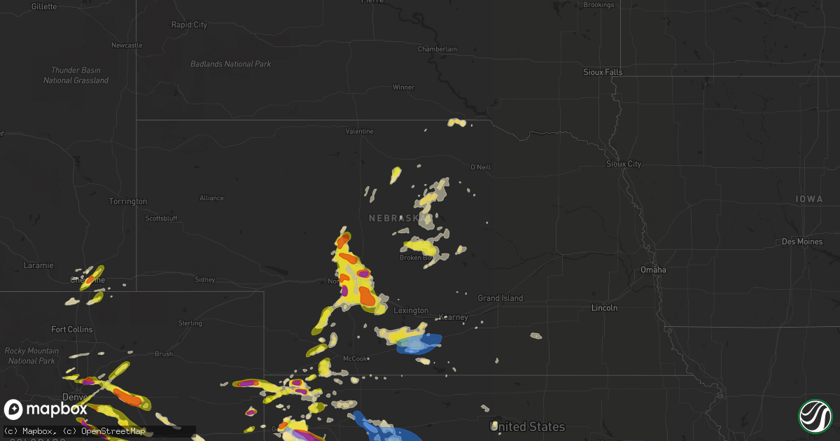
Hail Map in Nebraska on June 8, 2019
Get this storm
June 8 map
$229
one time, instant access
Download today. No call, no setup
Keep the $229
Bought the map and want the full workflow? Apply the entire $229 to a subscription within 7 days. None of it is wasted.
Every map, not just this one
This buys you this map. Subscription and you get every map we run, in the markets you choose from a few cities to whole states to nationwide. Plus real-time alerts the moment a storm fires.
Contact data
Name, contact info, occupancy, even credit band for addresses in the footprint. You go from where it hit to who to call.
Become the source they trust
Unlimited branding weather history reports on demand. You already have the documented answer ready for the property owner, and you are the one who showed up with it.
Property data and RoofTrace estimates
Pull up any address you have got, its value and the exact code rules for that jurisdiction, straight from One Click Code. Then RoofTrace estimates the squares, pitch, and roof value, priced the way you price.
Storm reports in Nebraska
Nebraska
| Date | Description |
|---|---|
| 06/08/20196:20 PM CDT | A local report indicates 1.00 inch wind near 5 W BRADY |
| 06/08/20195:54 PM CDT | A local report indicates 1.25 inch wind near 2 S NORTH PLATTE |
| 06/08/20195:50 PM CDT | . |
| 06/08/20195:48 PM CDT | A local report indicates 1.75 inch wind near 2 S NORTH PLATTE |
| 06/08/20195:37 PM CDT | A local report indicates 1.00 inch wind near NORTH PLATTE |
| 06/08/20195:35 PM CDT | Corrects previous hail report from north platte. |
| 06/08/20195:30 PM CDT | Reported at bailey yard. At least four automotive windshields cracked... Report of broken tail lights and broken side mirrors. |
| 06/08/20195:27 PM CDT | A local report indicates 1.00 inch wind near 12 NE NORTH PLATTE |
| 06/08/20195:26 PM CDT | A local report indicates 1.00 inch wind near 15 NNE NORTH PLATTE |
| 06/08/20195:25 PM CDT | A local report indicates 58 MPH wind near 4 N NORTH PLATTE |
| 06/08/20195:24 PM CDT | Reported at bailey yard. At least four automotive windshields cracked... Report of broken tail lights and broken side mirrors. |
| 06/08/20194:55 PM CDT | Delayed report. Rancher called in to report ping pong sized hail at onset of hail. Time estimated from radar. |
| 06/08/20194:45 PM CDT | A local report indicates 1.50 inch wind near 18 NNW NORTH PLATTE |
| 06/08/20194:31 PM CDT | A local report indicates 1.00 inch wind near 9 SE TRYON |
| 06/08/20193:40 PM CDT | A local report indicates 1.00 inch wind near 4 NE TRYON |
| 06/08/20195:06 AM CDT | At 1005 PM CDT, severe thunderstorms were located along a line extending from near Hastings to Roseland to near Bladen, moving east at 25 mph. HAZARD...60 mph wind gusts. SOURCE...Radar indicated. IMPACT...Expect damage to roofs, siding, and trees. Locations impacted include... Hastings, Roseland, Holstein and Ayr. |
| 06/08/20194:43 AM CDT | At 942 PM CDT, a severe thunderstorm was located 11 miles southeast of McDonald, or 17 miles southwest of Atwood, moving northeast at 35 mph. HAZARD...Ping pong ball size hail and 60 mph wind gusts. SOURCE...Radar indicated. IMPACT...People and animals outdoors will be injured. Expect hail damage to roofs, siding, windows, and vehicles. Expect wind damage to roofs, siding, and trees. Locations impacted include... Atwood, McDonald, Herndon, Danbury, Ludell, Blakeman and Traer. |
| 06/08/20194:01 AM CDT | At 901 PM CDT, severe thunderstorms were located along a line extending from near Funk to near Wilcox to 6 miles southwest of Ragan, moving east at 40 mph. HAZARD...60 mph wind gusts. SOURCE...Radar indicated. IMPACT...Expect damage to roofs, siding, and trees. Locations impacted include... Minden, Axtell, Hildreth, Wilcox, Campbell, Funk, Upland, Heartwell and Norman. |
| 06/08/20193:55 AM CDT | At 854 PM CDT, severe thunderstorms were located along a line extending from 4 miles south of Culbertson to 4 miles west of McDonald, moving southeast at 20 mph. HAZARD...70 mph wind gusts and ping pong ball size hail. SOURCE...Radar indicated. IMPACT...People and animals outdoors will be injured. Expect hail damage to roofs, siding, windows, and vehicles. Expect considerable tree damage. Wind damage is also likely to mobile homes, roofs, and outbuildings. Locations impacted include... Atwood, Trenton, Bird City, McDonald, Blakeman and Beardsley. |
| 06/08/20193:44 AM CDT | At 844 PM CDT, severe thunderstorms were located along a line extending from near Loomis to Atlanta to Oxford, moving southeast at 15 mph. HAZARD...70 mph wind gusts and nickel size hail. SOURCE...Radar indicated. IMPACT...Expect considerable tree damage. Damage is likely to mobile homes, roofs, and outbuildings. Locations impacted include... Holdrege, Alma, Oxford, Bertrand, Orleans, Loomis, Funk, Stamford, Republican City, Atlanta, Huntley, Ragan, Hollinger and Harlan County Dam. |
| 06/08/20193:41 AM CDT | At 841 PM CDT, a severe thunderstorm was located 8 miles north of McDonald, or 14 miles southeast of Benkelman, moving east at 30 mph. HAZARD...Ping pong ball size hail and 60 mph wind gusts. SOURCE...Radar indicated. IMPACT...People and animals outdoors will be injured. Expect hail damage to roofs, siding, windows, and vehicles. Expect wind damage to roofs, siding, and trees. Locations impacted include... Bird City, McDonald, Blakeman, Beardsley and Wheeler. |
| 06/08/20193:29 AM CDT | At 828 PM CDT, a severe thunderstorm was located over Weissert, or 11 miles east of Broken Bow, moving southeast at 25 mph. HAZARD...60 mph wind gusts and quarter size hail. SOURCE...Radar indicated. IMPACT...Hail damage to vehicles is expected. Expect wind damage to roofs, siding, and trees. Locations impacted include... Ansley, Mason City, Comstock, Weissert, Westerville, Arcadia Diversion Dam State Wildlife Management Area, Gavin Siding and Wescott.This includes the following highways... Highway 183 between mile markers 88 and 109. Highway 2 between mile markers 291 and 307. Highway 92 between mile markers 300 and 308. |
| 06/08/20193:13 AM CDT | At 812 PM CDT, a severe thunderstorm was located 8 miles north of Edison, or 21 miles west of Holdrege, moving east at 40 mph. HAZARD...60 mph wind gusts and nickel size hail. SOURCE...Radar indicated. IMPACT...Expect damage to roofs, siding, and trees. Locations impacted include... Holdrege, Arapahoe, Bertrand, Loomis and Atlanta. |
| 06/08/20192:52 AM CDT | At 752 PM CDT, a severe thunderstorm was located near Merna, or 9 miles north of Broken Bow, moving east at 20 mph. HAZARD...60 mph wind gusts and quarter size hail. SOURCE...Radar indicated. IMPACT...Hail damage to vehicles is expected. Expect wind damage to roofs, siding, and trees. Locations impacted include... Merna, Comstock, Weissert, Westerville, Lillian, Round Valley, Arcadia Diversion Dam State Wildlife Management Area and Wescott.This includes the following highways... Highway 183 between mile markers 95 and 112. Highway 2 between mile markers 267 and 270. Highway 92 near mile marker 273. |
| 06/08/20192:12 AM CDT | At 712 PM CDT, severe thunderstorms were located along a line extending from Gothenburg to 11 miles northwest of Eustis, moving southeast at 25 mph. HAZARD...60 mph wind gusts and half dollar size hail. SOURCE...Radar indicated. IMPACT...Hail damage to vehicles is expected. Expect wind damage to roofs, siding, and trees. Locations impacted include... Cozad, Gothenburg, Willow Island and Farnam. This includes Interstate 80 between mile markers 209 and 234. |
| 06/08/20191:41 AM CDT | At 641 PM CDT, a severe thunderstorm was located 9 miles southwest of Gothenburg, or 18 miles northeast of Curtis, moving southeast at 25 mph. HAZARD...Ping pong ball size hail and 60 mph wind gusts. SOURCE...Radar indicated. IMPACT...People and animals outdoors will be injured. Expect hail damage to roofs, siding, windows, and vehicles. Expect wind damage to roofs, siding, and trees. Locations impacted include... Cozad, Gothenburg, Willow Island and Farnam. This includes Interstate 80 between mile markers 209 and 222. |
| 06/08/20191:13 AM CDT | At 613 PM CDT, severe thunderstorms were located along a line extending from 12 miles southwest of Callaway to near Brady to near Wellfleet to 10 miles south of Dickens, moving southeast at 30 mph. HAZARD...60 mph wind gusts and half dollar size hail. SOURCE...Radar indicated. IMPACT...Hail damage to vehicles is expected. Expect wind damage to roofs, siding, and trees. Locations impacted include... Curtis, Hayes Center, Brady, Eustis, Wellfleet, Moorefield, Stockville, Dickens, Maywood, Quick, Cottonwood Canyon State Wildlife Management Area, Etna, Hansen Memorial Reserve State Wildlife Management Area, Jeffrey Canyon State Wildlife Management Area, Hayes Center State Wildlife Management Area, Marengo, Vroman, Somerset and Dancing Leaf Earth Lodge.This includes the following highways... Interstate 80 in Nebraska between mile markers 192 and 207. Highway 83 between mile markers 30 and 69. |
| 06/08/201912:59 AM CDT | At 559 PM CDT, severe thunderstorms were located along a line extending from 10 miles northeast of Brady to 11 miles northeast of Wellfleet, moving southeast at 30 mph. HAZARD...60 mph wind gusts and half dollar size hail. SOURCE...Radar indicated. IMPACT...Hail damage to vehicles is expected. Expect wind damage to roofs, siding, and trees. Locations impacted include... Cozad, Gothenburg, Willow Island and Farnam. This includes Interstate 80 between mile markers 209 and 232. |
| 06/08/201912:37 AM CDT | At 537 PM CDT, a severe thunderstorm was located 6 miles southwest of Palisade, or 13 miles northwest of Trenton, moving northeast at 25 mph. HAZARD...60 mph wind gusts and half dollar size hail. SOURCE...Radar indicated. IMPACT...Hail damage to vehicles is expected. Expect wind damage to roofs, siding, and trees. Locations impacted include... Palisade. |
| 06/08/201912:17 AM CDT | At 516 PM CDT, severe thunderstorms were located along a line extending from near Gandy to near Hershey, moving southeast at 20 mph. HAZARD...Ping pong ball size hail and 60 mph wind gusts. SOURCE...Radar indicated. IMPACT...People and animals outdoors will be injured. Expect hail damage to roofs, siding, windows, and vehicles. Expect wind damage to roofs, siding, and trees. Locations impacted include... North Platte, Hershey, Brady, Maxwell, Wellfleet, Gandy, Lake Maloney State Recreation Area, North Platte Airport, Keith, Cottonwood Canyon State Wildlife Management Area, Etna, Jeffrey Canyon State Wildlife Management Area, Birdwood and Somerset.This includes the following highways... Highway 92 between mile markers 233 and 243. Highway 97 between mile markers 1 and 7. Interstate 80 in Nebraska between mile markers 161 and 203. Highway 83 between mile markers 57 and 110. |
| 06/07/201911:44 PM CDT | At 443 PM CDT, a severe thunderstorm was located 7 miles south of Ringgold, or 13 miles southeast of Tryon, moving southeast at 10 mph. HAZARD...Ping pong ball size hail and 60 mph wind gusts. SOURCE...Radar indicated. IMPACT...People and animals outdoors will be injured. Expect hail damage to roofs, siding, windows, and vehicles. Expect wind damage to roofs, siding, and trees. Locations impacted include... North Platte and Ringgold. This includes the following highways... Highway 92 between mile markers 212 and 224. Highway 97 between mile markers 1 and 22. Highway 83 between mile markers 85 and 107. |
| 06/07/201911:15 PM CDT | At 415 PM CDT, a severe thunderstorm was located near Ringgold, or near Tryon, moving east at 10 mph. HAZARD...60 mph wind gusts and quarter size hail. SOURCE...Radar indicated. IMPACT...Hail damage to vehicles is expected. Expect wind damage to roofs, siding, and trees. Locations impacted include... Ringgold.This includes the following highways... Highway 92 between mile markers 206 and 224. Highway 97 between mile markers 18 and 26. |
| 06/07/201910:34 PM CDT | At 334 PM CDT, a severe thunderstorm was located 7 miles north of Ringgold, or 7 miles northeast of Tryon, moving northeast at 10 mph. HAZARD...60 mph wind gusts and half dollar size hail. SOURCE...Radar indicated. IMPACT...Hail damage to vehicles is expected. Expect wind damage to roofs, siding, and trees. Locations impacted include... Tryon and Ringgold. This includes the following highways... Highway 92 between mile markers 203 and 215. Highway 97 between mile markers 26 and 39. Highway 83 near mile marker 120. |
| 06/07/201910:30 PM CDT | Estimated 55-60 mph winds. Winds were strong for about 5-7 minutes. |
| 06/07/20199:01 PM CDT | Delayed report. |
| 06/07/20198:57 PM CDT | A local report indicates 61 MPH wind near HOLDREGE AIRPORT |
| 06/07/20198:55 PM CDT | Power was lost in part of town... Sparks were reported at a substation. 4 power poles were damaged near 18th ave. And lincoln st. A large tree was downed at the cemeter |
| 06/07/20198:50 PM CDT | A local report indicates 63 MPH wind near 1 NW HOLDREGE |
| 06/07/20198:47 PM CDT | A local report indicates 60 MPH wind near 4 NNE OXFORD |
| 06/07/20198:46 PM CDT | A local report indicates 70 MPH wind near 3 SSE LOOMIS |
| 06/07/20198:45 PM CDT | Wind gusts estimated to be at least 70 mph. |
| 06/07/20198:43 PM CDT | A local report indicates 58 MPH wind near 3 WNW HOLDREGE |
| 06/07/20198:40 PM CDT | A local report indicates 58 MPH wind near 1 ESE LOOMIS |
| 06/07/20198:39 PM CDT | A local report indicates 60 MPH wind near ATLANTA |
| 06/07/20198:36 PM CDT | A local report indicates 70 MPH wind near 1 N OXFORD |
| 06/07/20198:30 PM CDT | A local report indicates 64 MPH wind near 6 WNW ATLANTA |
| 06/07/20198:30 PM CDT | Delayed report. |
| 06/07/20198:14 PM CDT | Measured on handheld anemometer. |
| 06/07/20198:11 PM CDT | Wind measured on a hand held anemometer. |
| 06/07/20198:09 PM CDT | Report of power pole/power line damage in town. Power line lying across the hwy 34/283 junction. Tree limbs of 6-8 inches downed. This spotter measured a 73 mph wind on |
| 06/07/20197:54 PM CDT | A local report indicates 1.00 inch wind near 3 NE MERNA |
All States Impacted by Hail Map on June 8, 2019
Cities Impacted by Hail Map on June 8, 2019
- Goodland, KS
- McDonald, KS
- Colby, KS
- Levant, KS
- Longmont, CO
- Boulder, CO
- Lafayette, CO
- Strasburg, CO
- Byers, CO
- Burwell, NE
- Stuart, NE
- Bassett, NE
- Sargent, NE
- Atkinson, NE
- Taylor, NE
- Amelia, NE
- Edson, KS
- Winona, KS
- Brewster, KS
- Glen Elder, KS
- Grinnell, KS
- Ainsworth, NE
- Johnstown, NE
- Tryon, NE
- Seneca, NE
- Ansley, NE
- Anselmo, NE
- Broken Bow, NE
- Westerville, NE
- Comstock, NE
- Merna, NE
- Oberlin, KS
- Franktown, CO
- Castle Rock, CO
- Elizabeth, CO
- Flagler, CO
- Bird City, KS
- Sedalia, CO
- Brady, NE
- Maxwell, NE
- Newfolden, MN
- Viking, MN
- Deer Trail, CO
- Bennett, CO
- Selden, KS
- Wellington, CO
- Wellfleet, NE
- Holbrook, NE
- Bertrand, NE
- Elwood, NE
- Eustis, NE
- Arapahoe, NE
- North Platte, NE
- Atwood, KS
- Cheyenne, WY
- Keenesburg, CO
- Hudson, CO
- Brighton, CO
- Arlington, KS
- Turon, KS
- Cunningham, KS
- Kingman, KS
- Hoxie, KS
- Palisade, NE
- Nekoma, KS
- Saint Francis, KS
- Herndon, KS
- Erie, CO
- Louisville, CO
- Wannaska, MN
- Roseau, MN
- Salol, MN
- Ramah, CO
- Agate, CO
- Stratton, NE
- Trenton, NE
- McCracken, KS
- Matheson, CO
- Limon, CO
- Watkins, CO
- Aurora, CO
- Parker, CO
- Kiowa, CO
- Quinter, KS
- Long Pine, NE
- Hayes Center, NE
- Orleans, NE
- Oxford, NE
- Tipton, KS
- Thief River Falls, MN
- Vidalia, GA
- Lyons, GA
- Grygla, MN
- Elbert, CO
- La Salle, CO
- Simla, CO
- Kenesaw, NE
- Calhan, CO
- Hennessey, OK
- Berthoud, CO
- Platteville, CO
- Mead, CO
- Shickley, NE
- Geneva, NE
- Brownell, KS
- Register, GA
- Vernon, CO
- Wray, CO
- Eckley, CO
- Wallace, KS
- Monument, KS
- Utica, KS
- Morland, KS
- Middle River, MN
- Ord, NE
- Arcadia, NE
- Crookston, MN
- Ames, OK
- Drummond, OK
- Ransom, KS
- Arnold, KS
- Curtis, NE
- Thedford, NE
- Cheyenne Wells, CO
- Carr, CO
- Nunn, CO
- Sutton, NE
- Hudson, KS
- St John, KS
- Collyer, KS
- Wakita, OK
- Nash, OK
- Burlington, OK
- Jet, OK
- Norcatur, KS
- Idalia, CO
- Yuma, CO
- Wakeeney, KS
- Gregory, SD
- Healy, KS
- Dighton, KS
- Gove, KS
- Naper, NE
- Butte, NE
- Scott City, KS
- Norton, KS
- Bonesteel, SD
- Ravenna, NE
- Grover, CO
- Loomis, NE
- Burlington, CO
- Kit Carson, CO
- Hoisington, KS
- Sharon, KS
- Grainfield, KS
- Hays, KS
- Ellis, KS
- Hill City, KS
- Dickens, NE
- Wallace, NE
- Denver, CO
- Thornton, CO
- Henderson, CO
- Abbyville, KS
- Helena, OK
- Edison, NE
- Gothenburg, NE
- Leoti, KS
- McCamey, TX
- Culbertson, NE
- Geneseo, KS
- Commerce City, CO
- Otis, KS
- Olmitz, KS
- Fe Warren Afb, WY
- Farnam, NE
- Moorefield, NE
- Stapleton, NE
- Claflin, KS
- McCook, NE
- Borup, MN
- Georgetown, MN
- Holdrege, NE
- Smithfield, NE
- Cambridge, NE
- Stamford, NE
- Broomfield, CO
- Oakley, KS
- Burke, SD
- Boynton Beach, FL
- Gorham, KS
- Russell, KS
- Penokee, KS
- Ogallah, KS
- Naponee, NE
- Buena Vista, GA
- Cozad, NE
- Englewood, CO
- Littleton, CO
- Raymond, KS
- Pompano Beach, FL
- Coral Springs, FL
- Meno, OK
- Amenia, ND
- Phillipsburg, KS
- Kanorado, KS
- Larned, KS
- Bison, KS
- Carpenter, WY
- Guide Rock, NE
- Blue Hill, NE
- Elm Creek, NE
- Atlanta, NE
- Overton, NE
- Gatzke, MN
- Waldron, KS
- Hazelton, KS
- Kiowa, KS
- Rush Center, KS
- Euclid, MN
- Buxton, ND
- West Palm Beach, FL
- Murdock, KS
- Milton, FL
- Arnold, NE
- Ellinwood, KS
- Miami Gardens, FL
- Opa Locka, FL
- Greenwood, SC
- Ericson, NE
- Beloit, KS
- Wiggins, CO
- Sebring, FL
- Caledonia, ND
- Sylvia, KS
- Stafford, KS
- Platte, SD
- Great Bend, KS
- Wheatland, ND
- Indianola, NE
- Reynolds, ND
- Roggen, CO
- Varnville, SC
- Alma, NE
- Downs, KS
- Portis, KS
- Ness City, KS
- Medicine Lodge, KS
- Hitchcock, SD
- Minden, NE
- Pawnee Rock, KS
- Red Cloud, NE
- Max, NE
- Kersey, CO
- Plevna, KS
- Theodore, AL
- Irvington, AL
- Lake Worth, FL
- Genoa, CO
- Delray Beach, FL
- Boca Raton, FL
- Victoria, KS
- Marienthal, KS
- Fertile, MN
- Pleasanton, NE
- Park, KS
- Benkelman, NE
- Warren, MN
- Doland, SD
- Cherokee, OK
- Waterloo, SC
- Cross Hill, SC
- Chambers, NE
- Bloomington, NE
- Ninety Six, SC
- Holyrood, KS
- Sterling, KS
- Pretty Prairie, KS
- Mills, NE
- Brewster, NE
- Gary, MN
- Nielsville, MN
- Leonard, ND
- North Loup, NE
- Kearney, NE
- Alexander, KS
- Isabel, KS
- Bushton, KS
- Goltry, OK
- Ringwood, OK
- Wauneta, NE
- Schoenchen, KS
- Bazine, KS
- La Crosse, KS
- Bunker Hill, KS
- Dorrance, KS
- Pfeifer, KS
- Liebenthal, KS
- Albert, KS
- Plainville, KS
- Bogue, KS
- Palco, KS
- Funk, NE
- Lone Tree, CO
- Louviers, CO
- Hinesville, GA
- Fort Stewart, GA
- Midway, GA
- Fleming, GA
- Argusville, ND
- Felton, MN
- Horace, ND
- Hendrum, MN
- Fargo, ND
- Halstad, MN
- Ada, MN
- Mapleton, ND
- West Fargo, ND
- Perley, MN
- Glyndon, MN
- Twin Valley, MN
- Ulen, MN
- Moorhead, MN
- Harwood, ND
- Davenport, ND
- Kindred, ND


