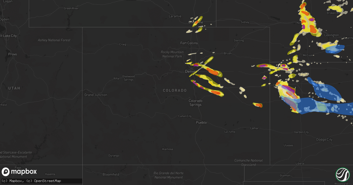
Hail Map in Colorado on June 8, 2019
Get this storm
June 8 map
$229
one time, instant access
Download today. No call, no setup
Keep the $229
Bought the map and want the full workflow? Apply the entire $229 to a subscription within 7 days. None of it is wasted.
Every map, not just this one
This buys you this map. Subscription and you get every map we run, in the markets you choose from a few cities to whole states to nationwide. Plus real-time alerts the moment a storm fires.
Contact data
Name, contact info, occupancy, even credit band for addresses in the footprint. You go from where it hit to who to call.
Become the source they trust
Unlimited branding weather history reports on demand. You already have the documented answer ready for the property owner, and you are the one who showed up with it.
Property data and RoofTrace estimates
Pull up any address you have got, its value and the exact code rules for that jurisdiction, straight from One Click Code. Then RoofTrace estimates the squares, pitch, and roof value, priced the way you price.
Storm reports in Colorado
Colorado
| Date | Description |
|---|---|
| 06/08/20196:55 PM CDT | A local report indicates 1.00 inch wind near 2 W AURORA |
| 06/08/20196:49 PM CDT | Corrects time of previous hail report from 1 n castle rock. |
| 06/08/20196:47 PM CDT | Corrects time of previous hail report from 2 nnw castle rock. |
| 06/08/20196:45 PM CDT | A local report indicates 1.00 inch wind near CASTLE ROCK |
| 06/08/20196:15 PM CDT | A local report indicates 1.00 inch wind near 4 NNE DENVER INTL AIRPO |
| 06/08/20196:11 PM CDT | A local report indicates 1.50 inch wind near BRIGHTON |
| 06/08/20196:05 PM CDT | A local report indicates 1.00 inch wind near 3 S BARR LAKE |
| 06/08/20195:55 PM CDT | A local report indicates 1.00 inch wind near 2 NE HENDERSON |
| 06/08/20195:25 PM CDT | A local report indicates 1.00 inch wind near 3 ENE BROOMFIELD |
| 06/08/20194:58 PM CDT | A local report indicates 1.00 inch wind near LOUISVILLE |
| 06/08/20194:55 PM CDT | A local report indicates 1.25 inch wind near 2 SSE ERIE |
| 06/08/20194:50 PM CDT | A local report indicates 1.00 inch wind near 2 S LAFAYETTE |
| 06/08/20194:39 PM CDT | Public reported 1 hail over hwy 385. Time estimated based on radar. |
| 06/08/20194:12 PM CDT | Public report via facebook of a landspout. |
| 06/08/20193:00 PM CDT | Landspout tornado reported. Has since dissipated. |
| 06/08/20193:43 AM CDT | At 842 PM MDT, a severe thunderstorm was located near Platteville, or 12 miles southwest of Greeley, moving east at 40 mph. HAZARD...Quarter size hail. SOURCE...Radar indicated. IMPACT...Damage to vehicles is expected. Locations impacted include... Southeastern Greeley, Evans, Milliken, Platteville, LaSalle, Kersey, Gilcrest, Gill and Milton Reservoir. |
| 06/08/20193:05 AM CDT | At 805 PM MDT, severe thunderstorms were located along a line extending from 5 miles southeast of Flagler to 8 miles northeast of Boyero, moving southeast at 40 mph. HAZARD...70 mph wind gusts and quarter size hail. SOURCE...Radar indicated. IMPACT...Hail damage to vehicles is expected. Expect considerable tree damage. Wind damage is also likely to mobile homes, roofs, and outbuildings. Locations impacted include... Flagler, Kit Carson, Firstview and Wild Horse. This includes Interstate 70 in Colorado between mile markers 394 and403. |
| 06/08/20192:42 AM CDT | At 742 PM MDT, a severe thunderstorm was located 12 miles northeast of Kutch, or 14 miles south of Limon, moving southeast at 30 mph. HAZARD...60 mph wind gusts and half dollar size hail. SOURCE...Radar indicated. IMPACT...Expect damage to roofs, siding, and trees. Hail damage to vehicles is expected. Locations impacted include... Hugo. |
| 06/08/20192:37 AM CDT | At 737 PM MDT, a severe thunderstorm was located 4 miles southeast of Arriba, or 8 miles southwest of Flagler, moving southeast at 30 mph. HAZARD...60 mph wind gusts and quarter size hail. SOURCE...Radar indicated. IMPACT...Hail damage to vehicles is expected. Expect wind damage to roofs, siding, and trees. Locations impacted include... Flagler and Seibert. This includes Interstate 70 in Colorado between mile markers 391 and408. |
| 06/08/20192:09 AM CDT | At 709 PM MDT, a severe thunderstorm was located near Simla, or 21 miles southwest of Limon, moving southeast at 35 mph. HAZARD...Ping pong ball size hail and 60 mph wind gusts. SOURCE...Radar indicated. IMPACT...Expect damage to roofs, siding, and trees. People and animals outdoors will be injured. Expect hail damage to roofs, siding, windows, and vehicles. Locations impacted include... Simla and Matheson. |
| 06/08/20192:00 AM CDT | At 700 PM MDT, a severe thunderstorm was located 7 miles east of Prospect Valley, or 27 miles southwest of Fort Morgan, moving northeast at 40 mph. HAZARD...60 mph wind gusts and half dollar size hail. SOURCE...Radar indicated. IMPACT...Expect damage to roofs, siding, and trees. Hail damage to vehicles is expected. Locations impacted include... Wiggins and Orchard. |
| 06/08/20191:55 AM CDT | At 655 PM MDT, a severe thunderstorm was located 11 miles southeast of Cottonwood Valley, or 16 miles north of Limon, moving southeast at 30 mph. HAZARD...70 mph wind gusts and ping pong ball size hail. SOURCE...Radar indicated. IMPACT...Expect considerable tree damage. Damage is likely to mobile homes, roofs, and outbuildings. People and animals outdoors will be injured. Expect hail damage to roofs, siding, windows, and vehicles. Locations impacted include... Genoa. |
| 06/08/20191:46 AM CDT | At 646 PM MDT, a severe thunderstorm was located 5 miles northwest of Ramah, or 30 miles west of Limon, moving southeast at 40 mph. HAZARD...Ping pong ball size hail and 60 mph wind gusts. SOURCE...Radar indicated. IMPACT...Expect damage to roofs, siding, and trees. People and animals outdoors will be injured. Expect hail damage to roofs, siding, windows, and vehicles. This severe thunderstorm will remain over mainly rural areas of central Elbert County. |
| 06/08/20191:33 AM CDT | At 633 PM MDT, a severe thunderstorm was located 9 miles east of Denver International Airport, or 27 miles northeast of Denver, moving northeast at 40 mph. HAZARD...Ping pong ball size hail and 60 mph wind gusts. SOURCE...Radar indicated. IMPACT...Expect damage to roofs, siding, and trees. People and animals outdoors will be injured. Expect hail damage to roofs, siding, windows, and vehicles. Locations impacted include... Prospect Valley. |
| 06/08/20191:28 AM CDT | At 628 PM MDT, a severe thunderstorm was located 4 miles west of Cottonwood Valley, or 29 miles north of Limon, moving southeast at 35 mph. HAZARD...Ping pong ball size hail and 60 mph wind gusts. SOURCE...Radar indicated. IMPACT...Expect damage to roofs, siding, and trees. People and animals outdoors will be injured. Expect hail damage to roofs, siding, windows, and vehicles. Locations impacted include... Cottonwood Valley. |
| 06/08/20191:24 AM CDT | At 624 PM MDT, a severe thunderstorm was located 12 miles northeast of Kiowa, or 33 miles northwest of Limon, moving southeast at 55 mph. HAZARD...60 mph wind gusts and half dollar size hail. SOURCE...Radar indicated. IMPACT...Expect damage to roofs, siding, and trees. Hail damage to vehicles is expected. This severe thunderstorm will remain over mainly rural areas of north central Elbert County. |
| 06/08/20191:11 AM CDT | At 611 PM MDT, a severe thunderstorm was located near Elizabeth, or 32 miles southeast of Denver, moving east at 30 mph. HAZARD...60 mph wind gusts and half dollar size hail. SOURCE...Radar indicated. IMPACT...Expect damage to roofs, siding, and trees. Hail damage to vehicles is expected. Locations impacted include... Elbert, Elizabeth, Kiowa and Ponderosa Park. |
| 06/08/201912:58 AM CDT | At 558 PM MDT, a severe thunderstorm was located near Byers, or 41 miles northwest of Limon, moving southeast at 45 mph. HAZARD...Ping pong ball size hail and 60 mph wind gusts. SOURCE...Radar indicated. IMPACT...Expect damage to roofs, siding, and trees. People and animals outdoors will be injured. Expect hail damage to roofs, siding, windows, and vehicles. Locations impacted include... Deer Trail, Strasburg and Byers. |
| 06/08/201912:48 AM CDT | At 548 PM MDT, a severe thunderstorm was located 6 miles southeast of Arapahoe Park, or 24 miles southeast of Denver, moving east at 35 mph. HAZARD...Ping pong ball size hail and 60 mph wind gusts. SOURCE...Radar indicated. IMPACT...Expect damage to roofs, siding, and trees. People and animals outdoors will be injured. Expect hail damage to roofs, siding, windows, and vehicles. This severe thunderstorm will remain over mainly rural areas of northwestern Elbert and south central Arapahoe Counties. |
| 06/08/201912:45 AM CDT | At 545 PM MDT, a severe thunderstorm was located over southern Denver, moving northeast at 35 mph. HAZARD...60 mph wind gusts and quarter size hail. SOURCE...Radar indicated. IMPACT...Expect damage to roofs, siding, and trees. Hail damage to vehicles is expected. Locations impacted include... Denver, Aurora, Centennial, northern Highlands Ranch, northeastern Littleton, Englewood, Greenwood Village, Denver International Airport, D.I.A Terminal and Concourses, Sheridan, Watkins and Buckley AFB. |
| 06/08/201912:44 AM CDT | At 544 PM MDT, a severe thunderstorm was located near Castle Pines, or 21 miles southeast of Denver, moving east at 35 mph. HAZARD...Ping pong ball size hail and 60 mph wind gusts. SOURCE...Radar indicated. IMPACT...Expect damage to roofs, siding, and trees. People and animals outdoors will be injured. Expect hail damage to roofs, siding, windows, and vehicles. Locations impacted include... Castle Rock, Parker, Franktown, The Pinery and southeastern Castle Pines. |
| 06/08/201912:25 AM CDT | At 525 PM MDT, a severe thunderstorm was located 7 miles northeast of Denver International Airport, or 25 miles northeast of Denver, moving east at 25 mph. HAZARD...Ping pong ball size hail. SOURCE...Radar indicated. IMPACT...People and animals outdoors will be injured. Expect damage to roofs, siding, windows, and vehicles. This severe thunderstorm will remain over mainly rural areas of central Adams County. |
| 06/08/201912:22 AM CDT | At 522 PM MDT, a severe thunderstorm was located 4 miles south of Keenesburg, or 28 miles south of Greeley, moving east at 35 mph. HAZARD...Half dollar size hail. SOURCE...Radar indicated. IMPACT...Damage to vehicles is expected. Locations impacted include... Hudson, Keenesburg, Prospect Valley and Roggen. |
| 06/07/201911:58 PM CDT | At 457 PM MDT, a severe thunderstorm was located over Barr Lake, or 16 miles northeast of Denver, moving east at 30 mph. HAZARD...Half dollar size hail. SOURCE...Radar indicated. IMPACT...Damage to vehicles is expected. Locations impacted include... Northeastern Commerce City, Brighton, Denver International Airport, D.I.A Terminal and Concourses and Barr Lake. |
| 06/07/201911:35 PM CDT | At 434 PM MDT, a severe thunderstorm was located 4 miles north of Erie, or 24 miles north of Denver, moving east at 35 mph. HAZARD...Ping pong ball size hail and 60 mph wind gusts. SOURCE...Radar indicated. IMPACT...Expect damage to roofs, siding, and trees. People and animals outdoors will be injured. Expect hail damage to roofs, siding, windows, and vehicles. Locations impacted include... Thornton, northeastern Westminster, Broomfield, northern Northglenn, Brighton, Lafayette, Louisville, Erie, Firestone, Frederick, Fort Lupton, Lochbuie, Dacono, Barr Lake, Todd Creek and Niwot. |
| 06/07/201910:39 PM CDT | At 339 PM MDT, a severe thunderstorm was located over Lafayette, or 18 miles northwest of Denver, moving east at 15 mph. HAZARD...60 mph wind gusts and quarter size hail. SOURCE...Radar indicated. IMPACT...Expect damage to roofs, siding, and trees. Hail damage to vehicles is expected. Locations impacted include... Northern Thornton, northeastern Westminster, Broomfield, Lafayette, Louisville, Erie, Superior and Todd Creek. |
| 06/07/20199:52 PM CDT | . |
| 06/07/20199:47 PM CDT | At 247 PM MDT, a severe thunderstorm was located 4 miles north of Kanorado, moving east at 20 mph. HAZARD...60 mph wind gusts and quarter size hail. SOURCE...Radar indicated. IMPACT...Hail damage to vehicles is expected. Expect wind damage to roofs, siding, and trees. Locations impacted include... Kanorado and Ruleton. This includes the following highways... Interstate 70 in Kansas between mile markers 0 and 13. Interstate 70 in Colorado between mile markers 447 and 450. |
| 06/07/20199:43 PM CDT | . |
| 06/07/20198:56 PM CDT | . |
| 06/07/20198:54 PM CDT | At 154 PM MDT, a severe thunderstorm was located over Burlington, moving east at 15 mph. HAZARD...Ping pong ball size hail and 60 mph wind gusts. SOURCE...Radar indicated. IMPACT...People and animals outdoors will be injured. Expect hail damage to roofs, siding, windows, and vehicles. Expect wind damage to roofs, siding, and trees. Locations impacted include... Burlington.This includes the following highways... Interstate 70 in Colorado between mile markers 431 and 450. Highway 385 between mile markers 179 and 198. |
| 06/07/20198:20 PM CDT | Small amount. |
| 06/07/20198:09 PM CDT | A local report indicates 1.75 inch wind near 4 E RAMAH |
| 06/07/20197:49 PM CDT | A local report indicates 1.75 inch wind near 1 N CASTLE ROCK |
| 06/07/20197:35 PM CDT | Broken skylights. |
| 06/07/20197:30 PM CDT | A local report indicates 64 MPH wind near 13 ENE KIOWA |
| 06/07/20197:29 PM CDT | A local report indicates 1.50 inch wind near 12 NNE KIOWA |
| 06/07/20197:20 PM CDT | A local report indicates a tornado near 1 SSW FONDIS |
| 06/07/20197:17 PM CDT | A local report indicates 2.50 inch wind near 2 NNW CASTLE ROCK |
| 06/07/20197:13 PM CDT | A local report indicates 1.00 inch wind near 1 W MEAD |
| 06/07/20197:06 PM CDT | A local report indicates 1.50 inch wind near BYERS |
| 06/07/20197:02 PM CDT | A local report indicates 1.00 inch wind near FRANKTOWN |
| 06/07/20197:00 PM CDT | A local report indicates 1.00 inch wind near 4.6 NE KIOWA |
| 06/07/20197:00 PM CDT | A local report indicates 1.50 inch wind near 2 E CASTLE ROCK |
| 06/07/20197:00 PM CDT | A local report indicates 1.00 inch wind near 3 WSW MEAD |
All States Impacted by Hail Map on June 8, 2019
Cities Impacted by Hail Map on June 8, 2019
- Goodland, KS
- McDonald, KS
- Colby, KS
- Levant, KS
- Longmont, CO
- Boulder, CO
- Lafayette, CO
- Strasburg, CO
- Byers, CO
- Burwell, NE
- Stuart, NE
- Bassett, NE
- Sargent, NE
- Atkinson, NE
- Taylor, NE
- Amelia, NE
- Edson, KS
- Winona, KS
- Brewster, KS
- Glen Elder, KS
- Grinnell, KS
- Ainsworth, NE
- Johnstown, NE
- Tryon, NE
- Seneca, NE
- Ansley, NE
- Anselmo, NE
- Broken Bow, NE
- Westerville, NE
- Comstock, NE
- Merna, NE
- Oberlin, KS
- Franktown, CO
- Castle Rock, CO
- Elizabeth, CO
- Flagler, CO
- Bird City, KS
- Sedalia, CO
- Brady, NE
- Maxwell, NE
- Newfolden, MN
- Viking, MN
- Deer Trail, CO
- Bennett, CO
- Selden, KS
- Wellington, CO
- Wellfleet, NE
- Holbrook, NE
- Bertrand, NE
- Elwood, NE
- Eustis, NE
- Arapahoe, NE
- North Platte, NE
- Atwood, KS
- Cheyenne, WY
- Keenesburg, CO
- Hudson, CO
- Brighton, CO
- Arlington, KS
- Turon, KS
- Cunningham, KS
- Kingman, KS
- Hoxie, KS
- Palisade, NE
- Nekoma, KS
- Saint Francis, KS
- Herndon, KS
- Erie, CO
- Louisville, CO
- Wannaska, MN
- Roseau, MN
- Salol, MN
- Ramah, CO
- Agate, CO
- Stratton, NE
- Trenton, NE
- McCracken, KS
- Matheson, CO
- Limon, CO
- Watkins, CO
- Aurora, CO
- Parker, CO
- Kiowa, CO
- Quinter, KS
- Long Pine, NE
- Hayes Center, NE
- Orleans, NE
- Oxford, NE
- Tipton, KS
- Thief River Falls, MN
- Vidalia, GA
- Lyons, GA
- Grygla, MN
- Elbert, CO
- La Salle, CO
- Simla, CO
- Kenesaw, NE
- Calhan, CO
- Hennessey, OK
- Berthoud, CO
- Platteville, CO
- Mead, CO
- Shickley, NE
- Geneva, NE
- Brownell, KS
- Register, GA
- Vernon, CO
- Wray, CO
- Eckley, CO
- Wallace, KS
- Monument, KS
- Utica, KS
- Morland, KS
- Middle River, MN
- Ord, NE
- Arcadia, NE
- Crookston, MN
- Ames, OK
- Drummond, OK
- Ransom, KS
- Arnold, KS
- Curtis, NE
- Thedford, NE
- Cheyenne Wells, CO
- Carr, CO
- Nunn, CO
- Sutton, NE
- Hudson, KS
- St John, KS
- Collyer, KS
- Wakita, OK
- Nash, OK
- Burlington, OK
- Jet, OK
- Norcatur, KS
- Idalia, CO
- Yuma, CO
- Wakeeney, KS
- Gregory, SD
- Healy, KS
- Dighton, KS
- Gove, KS
- Naper, NE
- Butte, NE
- Scott City, KS
- Norton, KS
- Bonesteel, SD
- Ravenna, NE
- Grover, CO
- Loomis, NE
- Burlington, CO
- Kit Carson, CO
- Hoisington, KS
- Sharon, KS
- Grainfield, KS
- Hays, KS
- Ellis, KS
- Hill City, KS
- Dickens, NE
- Wallace, NE
- Denver, CO
- Thornton, CO
- Henderson, CO
- Abbyville, KS
- Helena, OK
- Edison, NE
- Gothenburg, NE
- Leoti, KS
- McCamey, TX
- Culbertson, NE
- Geneseo, KS
- Commerce City, CO
- Otis, KS
- Olmitz, KS
- Fe Warren Afb, WY
- Farnam, NE
- Moorefield, NE
- Stapleton, NE
- Claflin, KS
- McCook, NE
- Borup, MN
- Georgetown, MN
- Holdrege, NE
- Smithfield, NE
- Cambridge, NE
- Stamford, NE
- Broomfield, CO
- Oakley, KS
- Burke, SD
- Boynton Beach, FL
- Gorham, KS
- Russell, KS
- Penokee, KS
- Ogallah, KS
- Naponee, NE
- Buena Vista, GA
- Cozad, NE
- Englewood, CO
- Littleton, CO
- Raymond, KS
- Pompano Beach, FL
- Coral Springs, FL
- Meno, OK
- Amenia, ND
- Phillipsburg, KS
- Kanorado, KS
- Larned, KS
- Bison, KS
- Carpenter, WY
- Guide Rock, NE
- Blue Hill, NE
- Elm Creek, NE
- Atlanta, NE
- Overton, NE
- Gatzke, MN
- Waldron, KS
- Hazelton, KS
- Kiowa, KS
- Rush Center, KS
- Euclid, MN
- Buxton, ND
- West Palm Beach, FL
- Murdock, KS
- Milton, FL
- Arnold, NE
- Ellinwood, KS
- Miami Gardens, FL
- Opa Locka, FL
- Greenwood, SC
- Ericson, NE
- Beloit, KS
- Wiggins, CO
- Sebring, FL
- Caledonia, ND
- Sylvia, KS
- Stafford, KS
- Platte, SD
- Great Bend, KS
- Wheatland, ND
- Indianola, NE
- Reynolds, ND
- Roggen, CO
- Varnville, SC
- Alma, NE
- Downs, KS
- Portis, KS
- Ness City, KS
- Medicine Lodge, KS
- Hitchcock, SD
- Minden, NE
- Pawnee Rock, KS
- Red Cloud, NE
- Max, NE
- Kersey, CO
- Plevna, KS
- Theodore, AL
- Irvington, AL
- Lake Worth, FL
- Genoa, CO
- Delray Beach, FL
- Boca Raton, FL
- Victoria, KS
- Marienthal, KS
- Fertile, MN
- Pleasanton, NE
- Park, KS
- Benkelman, NE
- Warren, MN
- Doland, SD
- Cherokee, OK
- Waterloo, SC
- Cross Hill, SC
- Chambers, NE
- Bloomington, NE
- Ninety Six, SC
- Holyrood, KS
- Sterling, KS
- Pretty Prairie, KS
- Mills, NE
- Brewster, NE
- Gary, MN
- Nielsville, MN
- Leonard, ND
- North Loup, NE
- Kearney, NE
- Alexander, KS
- Isabel, KS
- Bushton, KS
- Goltry, OK
- Ringwood, OK
- Wauneta, NE
- Schoenchen, KS
- Bazine, KS
- La Crosse, KS
- Bunker Hill, KS
- Dorrance, KS
- Pfeifer, KS
- Liebenthal, KS
- Albert, KS
- Plainville, KS
- Bogue, KS
- Palco, KS
- Funk, NE
- Lone Tree, CO
- Louviers, CO
- Hinesville, GA
- Fort Stewart, GA
- Midway, GA
- Fleming, GA
- Argusville, ND
- Felton, MN
- Horace, ND
- Hendrum, MN
- Fargo, ND
- Halstad, MN
- Ada, MN
- Mapleton, ND
- West Fargo, ND
- Perley, MN
- Glyndon, MN
- Twin Valley, MN
- Ulen, MN
- Moorhead, MN
- Harwood, ND
- Davenport, ND
- Kindred, ND


