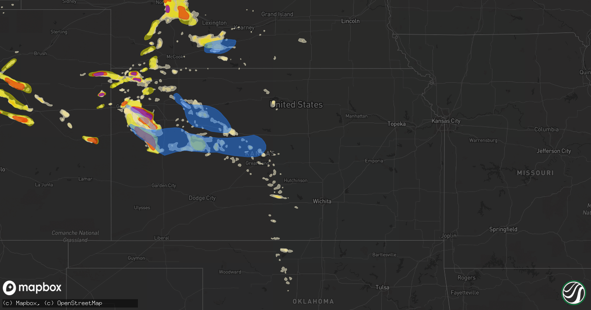
Hail Map in Kansas on June 8, 2019
Get this storm
June 8 map
$229
one time, instant access
Download today. No call, no setup
Keep the $229
Bought the map and want the full workflow? Apply the entire $229 to a subscription within 7 days. None of it is wasted.
Every map, not just this one
This buys you this map. Subscription and you get every map we run, in the markets you choose from a few cities to whole states to nationwide. Plus real-time alerts the moment a storm fires.
Contact data
Name, contact info, occupancy, even credit band for addresses in the footprint. You go from where it hit to who to call.
Become the source they trust
Unlimited branding weather history reports on demand. You already have the documented answer ready for the property owner, and you are the one who showed up with it.
Property data and RoofTrace estimates
Pull up any address you have got, its value and the exact code rules for that jurisdiction, straight from One Click Code. Then RoofTrace estimates the squares, pitch, and roof value, priced the way you price.
Storm reports in Kansas
Kansas
| Date | Description |
|---|---|
| 06/08/20196:37 PM CDT | Trained spotter reported hail size of 1.61 inches |
| 06/08/20196:35 PM CDT | . |
| 06/08/20196:30 PM CDT | A local report indicates 1.50 inch wind near BREWSTER |
| 06/08/20196:02 PM CDT | A local report indicates 2.00 inch wind near 1 N EDSON |
| 06/08/20195:51 PM CDT | . |
| 06/08/20195:15 PM CDT | A local report indicates 2.00 inch wind near 4 W EDSON |
| 06/08/20195:00 PM CDT | Hail is ongoing. Also spotter says tornado has dissipated. |
| 06/08/20194:55 PM CDT | Hail lasted 15 minutes with the largest hailstones around half dollar size. |
| 06/08/20194:55 PM CDT | One landspout tornado went back up into clouds. Another landspout tornado was reported on the ground at 3:55 pm mt. |
| 06/08/20194:53 PM CDT | Delayed report. While first tornado was ongoing from 3:48 pm storm report... Same spotter saw a second tornado develop at approximately the same location. |
| 06/08/20194:50 PM CDT | Delayed report... Storm chaser reported a landspout tornado saturday afternoon nw of goodland/s of st. Francis... Ks. Report came in via a picture on twitter. |
| 06/08/20194:48 PM CDT | Delayed report. 1st tornado of two. |
| 06/08/20194:40 PM CDT | Delayed report via facebook of pea to quarter size hail. Hail lasted about ten minutes. |
| 06/08/20194:35 PM CDT | Report via facebook. |
| 06/08/20194:28 PM CDT | A local report indicates 1.00 inch wind near 1 NW BREWSTER |
| 06/08/20194:15 PM CDT | Report via facebook of 2 inch hail. |
| 06/08/20196:37 AM CDT | At 1136 PM CDT, a severe thunderstorm was located 4 miles east of Hoxie, moving east at 25 mph. HAZARD...70 mph wind gusts and quarter size hail. SOURCE...Radar indicated. IMPACT...Hail damage to vehicles is expected. Expect considerable tree damage. Wind damage is also likely to mobile homes, roofs, and outbuildings. Locations impacted include... Hill City, Hoxie, Morland, Studley, Penokee, Saint Peter and Tasco. |
| 06/08/20196:34 AM CDT | At 1134 PM CDT, severe thunderstorms were located along a line extending from 6 miles south of Oakley to 15 miles east of Russell Springs to 11 miles west of Scott State Lake, moving east at 50 mph. These are very dangerous storms. HAZARD...80 mph wind gusts and golf ball size hail. SOURCE...Radar indicated. IMPACT...Flying debris will be dangerous to those caught without shelter. Mobile homes will be heavily damaged. Expect considerable damage to roofs, windows, and vehicles. Extensive tree damage and power outages are likely. Locations impacted include... Gove, Monument and The Monument Rocks. |
| 06/08/20196:29 AM CDT | At 1128 PM CDT, severe thunderstorms were located along a line extending from 11 miles north of Scott State Lake to 9 miles northeast of Leoti, moving southeast at 55 mph. These are very dangerous storms. HAZARD...80 mph wind gusts and ping pong ball size hail. SOURCE...Radar indicated. IMPACT...Flying debris will be dangerous to those caught without shelter. Mobile homes will be heavily damaged. Expect considerable damage to roofs, windows, and vehicles. Extensive tree damage and power outages are likely. Locations impacted include... Scott City, Dighton, Grigston, Healy, Friend, Scott State Lake, Modoc, Shallow Water, Manning, Pendennis, Amy and Shields. |
| 06/08/20196:10 AM CDT | At 1110 PM CDT, a severe thunderstorm was located 4 miles south of Selden, or 10 miles northwest of Hoxie, moving east at 40 mph. HAZARD...60 mph wind gusts and half dollar size hail. SOURCE...Radar indicated. IMPACT...Hail damage to vehicles is expected. Expect wind damage to roofs, siding, and trees. Locations impacted include... Hoxie, Selden, Tasco and Seguin. |
| 06/08/20196:03 AM CDT | At 1103 PM CDT, a severe thunderstorm was located near Russell Springs, or 23 miles northwest of Scott State Lake, moving southeast at 40 mph. HAZARD...Two inch hail and 60 mph wind gusts. SOURCE...Radar indicated. IMPACT...People and animals outdoors will be injured. Expect hail damage to roofs, siding, windows, and vehicles. Expect wind damage to roofs, siding, and trees. Locations impacted include... Scott State Lake. |
| 06/08/20195:27 AM CDT | At 1027 PM CDT, a severe thunderstorm was located 8 miles north of Rexford, or 19 miles southwest of Oberlin, moving east at 30 mph. HAZARD...Ping pong ball size hail and 60 mph wind gusts. SOURCE...Radar indicated. IMPACT...People and animals outdoors will be injured. Expect hail damage to roofs, siding, windows, and vehicles. Expect wind damage to roofs, siding, and trees. Locations impacted include... Selden, Jennings, Dresden and Leoville. |
| 06/08/20195:01 AM CDT | At 1001 PM MDT/1101 PM CDT/, a severe thunderstorm was located near Russell Springs, or 21 miles southwest of Oakley, moving southeast at 35 mph. HAZARD...Two inch hail and 60 mph wind gusts. SOURCE...Radar indicated. IMPACT...People and animals outdoors will be injured. Expect hail damage to roofs, siding, windows, and vehicles. Expect wind damage to roofs, siding, and trees. Locations impacted include... Leoti, Sharon Springs, Winona, Wallace, Russell Springs, Selkirk and Marienthal. |
| 06/08/20194:18 AM CDT | At 917 PM MDT/1017 PM CDT/, a severe thunderstorm was located 9 miles north of Wallace, or 14 miles northeast of Sharon Springs, moving southeast at 45 mph. HAZARD...60 mph wind gusts and quarter size hail. SOURCE...Radar indicated. IMPACT...Hail damage to vehicles is expected. Expect wind damage to roofs, siding, and trees. Locations impacted include... Sharon Springs, Winona, Wallace, Russell Springs and Mingo. This includes Interstate 70 in Kansas near mile marker 62. |
| 06/08/20194:10 AM CDT | . |
| 06/08/20194:08 AM CDT | Delayed report from june 9th. Multiple medium size branches down in sw wichita. |
| 06/08/20193:45 AM CDT | At 845 PM MDT, a severe thunderstorm was located 11 miles east of Kit Carson, or 12 miles west of Cheyenne Wells, moving southeast at 55 mph. HAZARD...60 mph wind gusts and quarter size hail. SOURCE...Radar indicated. IMPACT...Hail damage to vehicles is expected. Expect wind damage to roofs, siding, and trees. Locations impacted include... Cheyenne Wells, Arapahoe and Firstview. This includes Highway 385 between mile markers 136 and 158. |
| 06/08/20193:41 AM CDT | At 841 PM MDT/941 PM CDT/, a severe thunderstorm was located 4 miles southeast of Ruleton, moving east at 40 mph. HAZARD...60 mph wind gusts and half dollar size hail. SOURCE...Radar indicated. IMPACT...Hail damage to vehicles is expected. Expect wind damage to roofs, siding, and trees. Locations impacted include... Goodland, Brewster, Ruleton and Edson. This includes Interstate 70 in Kansas between mile markers 6 and 46. |
| 06/08/20193:15 AM CDT | Delayed report...estimated 60-70mph winds. |
| 06/08/20193:13 AM CDT | At 813 PM MDT/913 PM CDT/, a severe thunderstorm was located 15 miles south of Wray, moving east at 25 mph. HAZARD...Ping pong ball size hail and 60 mph wind gusts. SOURCE...Radar indicated. IMPACT...People and animals outdoors will be injured. Expect hail damage to roofs, siding, windows, and vehicles. Expect wind damage to roofs, siding, and trees. Locations impacted include... St. Francis and Beecher Island. |
| 06/08/20193:12 AM CDT | At 812 PM MDT/912 PM CDT/, a severe thunderstorm was located 7 miles north of Winona, or 14 miles south of Levant, moving southeast at 15 mph. HAZARD...70 mph wind gusts and ping pong ball size hail. SOURCE...Radar indicated. IMPACT...People and animals outdoors will be injured. Expect hail damage to roofs, siding, windows, and vehicles. Expect considerable tree damage. Wind damage is also likely to mobile homes, roofs, and outbuildings. Locations impacted include... Oakley, Brewster, Levant, Winona, Monument, Russell Springs and Mingo.This includes Interstate 70 in Kansas between mile markers 27 and 52,and between mile markers 58 and 73. |
| 06/08/20193:08 AM CDT | At 808 PM CDT, a severe thunderstorm was located 4 miles west of Trenton, moving east at 25 mph. HAZARD...Ping pong ball size hail and 60 mph wind gusts. SOURCE...Radar indicated. IMPACT...People and animals outdoors will be injured. Expect hail damage to roofs, siding, windows, and vehicles. Expect wind damage to roofs, siding, and trees. Locations impacted include... McCook, Trenton and Culbertson. |
| 06/08/20192:49 AM CDT | At 749 PM MDT, a severe thunderstorm was located 18 miles south of Eckley, or 19 miles southwest of Wray, moving east at 20 mph. HAZARD...60 mph wind gusts and half dollar size hail. SOURCE...Radar indicated. IMPACT...Hail damage to vehicles is expected. Expect wind damage to roofs, siding, and trees. Locations impacted include... Abarr, Beecher Island, Heartstrong, Idalia and Vernon. This includes Highway 385 between mile markers 209 and 210, andbetween mile markers 212 and 240. |
| 06/08/20192:26 AM CDT | At 725 PM MDT/825 PM CDT/, a severe thunderstorm was located 5 miles west of Brewster, moving southeast at 35 mph. This is a very dangerous storm. HAZARD...80 mph wind gusts and tennis ball size hail. SOURCE...Trained spotter reported tennis ball size hail and a rotating wall cloud. IMPACT...Flying debris will be dangerous to those caught without shelter. Mobile homes will be heavily damaged. Expect considerable damage to roofs, windows, and vehicles. Extensive tree damage and power outages are likely. Locations impacted include... Brewster, Winona and Edson. This includes Interstate 70 in Kansas between mile markers 22 and 47. |
| 06/08/20192:10 AM CDT | . |
| 06/08/20192:06 AM CDT | Asos station krsl russell municipal airport. |
| 06/08/20191:41 AM CDT | At 641 PM MDT/741 PM CDT/, a severe thunderstorm was located 5 miles west of Brewster, moving east at 20 mph. HAZARD...Ping pong ball size hail and 60 mph wind gusts. SOURCE...Radar indicated. IMPACT...People and animals outdoors will be injured. Expect hail damage to roofs, siding, windows, and vehicles. Expect wind damage to roofs, siding, and trees. Locations impacted include... Brewster, Levant and Edson. This includes Interstate 70 in Kansas between mile markers 22 and 48. |
| 06/08/20191:00 AM CDT | At 600 PM MDT/700 PM CDT/, a severe thunderstorm was located 9 miles northeast of Goodland, moving northeast at 20 mph. HAZARD...Ping pong ball size hail and 60 mph wind gusts. SOURCE...Trained weather spotters. IMPACT...People and animals outdoors will be injured. Expect hail damage to roofs, siding, windows, and vehicles. Expect wind damage to roofs, siding, and trees. Locations impacted include... Goodland and Edson. This includes Interstate 70 in Kansas between mile markers 19 and 35. |
| 06/08/201912:40 AM CDT | Mesonet station k5wky 1 ssw wakeeney. |
| 06/08/201912:35 AM CDT | At 535 PM MDT, a severe thunderstorm was located near Goodland, moving northeast at 20 mph. HAZARD...60 mph wind gusts and quarter size hail. SOURCE...Radar indicated. IMPACT...Hail damage to vehicles is expected. Expect wind damage to roofs, siding, and trees. Locations impacted include... Goodland.This includes Interstate 70 in Kansas between mile markers 15 and 23. |
| 06/08/201912:20 AM CDT | Mesonet station dw2812 scott city. |
| 06/08/201912:09 AM CDT | . |
| 06/07/201911:53 PM CDT | At 453 PM MDT/553 PM CDT/, a severe thunderstorm was located 13 miles south of St. Francis, moving east at 35 mph. HAZARD...60 mph wind gusts and half dollar size hail. SOURCE...Radar indicated. IMPACT...Hail damage to vehicles is expected. Expect wind damage to roofs, siding, and trees. Locations impacted include... Bird City. |
| 06/07/201911:35 PM CDT | One half mile east and one quarter mile north of hoxie. Peak gust 102.7 measured. 40 foot tv tower kinked in half. 6 inch branches snapped off. Live 10 to 12 inch pine |
| 06/07/201911:29 PM CDT | . |
| 06/07/201910:58 PM CDT | At 357 PM CDT, a severe thunderstorm was located 11 miles southwest of Benkelman, moving east at 10 mph. HAZARD...Ping pong ball size hail and 60 mph wind gusts. SOURCE...Radar indicated. IMPACT...People and animals outdoors will be injured. Expect hail damage to roofs, siding, windows, and vehicles. Expect wind damage to roofs, siding, and trees. Locations impacted include... St. Francis and Wheeler. |
| 06/07/201910:45 PM CDT | . |
| 06/07/201910:44 PM CDT | At 344 PM MDT/444 PM CDT/, a severe thunderstorm was located 6 miles southwest of St. Francis, moving northeast at 25 mph. HAZARD...Two inch hail and 70 mph wind gusts. SOURCE...Trained weather spotters. IMPACT...People and animals outdoors will be injured. Expect hail damage to roofs, siding, windows, and vehicles. Expect considerable tree damage. Wind damage is also likely to mobile homes, roofs, and outbuildings. Locations impacted include... St. Francis, Benkelman, Bird City and Wheeler. |
| 06/07/201910:09 PM CDT | At 309 PM MDT, a severe thunderstorm was located 6 miles southwest of Bonny Reservoir, moving northeast at 10 mph. HAZARD...60 mph wind gusts and half dollar size hail. SOURCE...Radar indicated. IMPACT...Hail damage to vehicles is expected. Expect wind damage to roofs, siding, and trees. Locations impacted include... Bonny Reservoir and Hale. This includes Highway 385 between mile markers 200 and 216. |
| 06/07/201910:05 PM CDT | . |
| 06/07/20199:55 PM CDT | Winona has lost power. Unknown whether from straightline winds or tornado. |
| 06/07/20199:50 PM CDT | . |
| 06/07/20199:45 PM CDT | Delayed report via social media. |
| 06/07/20199:30 PM CDT | Delayed report via facebook. |
| 06/07/20199:30 PM CDT | Delayed report via social media. |
| 06/07/20199:25 PM CDT | Storm chaser posted a picture on twitter of a possible tornado touchdown near the us40/cr220 intersection sw of winona... Ks at 2125 cdt. |
| 06/07/20199:19 PM CDT | . |
| 06/07/20199:08 PM CDT | . |
| 06/07/20199:02 PM CDT | . |
| 06/07/20199:00 PM CDT | Delayed report via social media. |
| 06/07/20198:55 PM CDT | . |
| 06/07/20198:51 PM CDT | Report from near the brewster exit on i70. |
| 06/07/20198:47 PM CDT | . |
| 06/07/20198:30 PM CDT | Corrects previous hail report from brewster. Report from near the brewster exit on i70. Corrected the previous report to correct the time of the report. |
| 06/07/20198:30 PM CDT | . |
| 06/07/20198:15 PM CDT | Public reported wind damage in edson last night with trees and power lines damaged. Public reported possibly caused by tornado. Public reported time as in the evening o |
| 06/07/20198:10 PM CDT | This is on road 29 south of edson. |
| 06/07/20198:10 PM CDT | Mesonet report of 60 mph wind gust. |
| 06/07/20198:00 PM CDT | Public reported via facebook golf ball to tennis ball size hail around 7 pm mdt at the overpass near mm 25 along i-70. |
All States Impacted by Hail Map on June 8, 2019
Cities Impacted by Hail Map on June 8, 2019
- Goodland, KS
- McDonald, KS
- Colby, KS
- Levant, KS
- Longmont, CO
- Boulder, CO
- Lafayette, CO
- Strasburg, CO
- Byers, CO
- Burwell, NE
- Stuart, NE
- Bassett, NE
- Sargent, NE
- Atkinson, NE
- Taylor, NE
- Amelia, NE
- Edson, KS
- Winona, KS
- Brewster, KS
- Glen Elder, KS
- Grinnell, KS
- Ainsworth, NE
- Johnstown, NE
- Tryon, NE
- Seneca, NE
- Ansley, NE
- Anselmo, NE
- Broken Bow, NE
- Westerville, NE
- Comstock, NE
- Merna, NE
- Oberlin, KS
- Franktown, CO
- Castle Rock, CO
- Elizabeth, CO
- Flagler, CO
- Bird City, KS
- Sedalia, CO
- Brady, NE
- Maxwell, NE
- Newfolden, MN
- Viking, MN
- Deer Trail, CO
- Bennett, CO
- Selden, KS
- Wellington, CO
- Wellfleet, NE
- Holbrook, NE
- Bertrand, NE
- Elwood, NE
- Eustis, NE
- Arapahoe, NE
- North Platte, NE
- Atwood, KS
- Cheyenne, WY
- Keenesburg, CO
- Hudson, CO
- Brighton, CO
- Arlington, KS
- Turon, KS
- Cunningham, KS
- Kingman, KS
- Hoxie, KS
- Palisade, NE
- Nekoma, KS
- Saint Francis, KS
- Herndon, KS
- Erie, CO
- Louisville, CO
- Wannaska, MN
- Roseau, MN
- Salol, MN
- Ramah, CO
- Agate, CO
- Stratton, NE
- Trenton, NE
- McCracken, KS
- Matheson, CO
- Limon, CO
- Watkins, CO
- Aurora, CO
- Parker, CO
- Kiowa, CO
- Quinter, KS
- Long Pine, NE
- Hayes Center, NE
- Orleans, NE
- Oxford, NE
- Tipton, KS
- Thief River Falls, MN
- Vidalia, GA
- Lyons, GA
- Grygla, MN
- Elbert, CO
- La Salle, CO
- Simla, CO
- Kenesaw, NE
- Calhan, CO
- Hennessey, OK
- Berthoud, CO
- Platteville, CO
- Mead, CO
- Shickley, NE
- Geneva, NE
- Brownell, KS
- Register, GA
- Vernon, CO
- Wray, CO
- Eckley, CO
- Wallace, KS
- Monument, KS
- Utica, KS
- Morland, KS
- Middle River, MN
- Ord, NE
- Arcadia, NE
- Crookston, MN
- Ames, OK
- Drummond, OK
- Ransom, KS
- Arnold, KS
- Curtis, NE
- Thedford, NE
- Cheyenne Wells, CO
- Carr, CO
- Nunn, CO
- Sutton, NE
- Hudson, KS
- St John, KS
- Collyer, KS
- Wakita, OK
- Nash, OK
- Burlington, OK
- Jet, OK
- Norcatur, KS
- Idalia, CO
- Yuma, CO
- Wakeeney, KS
- Gregory, SD
- Healy, KS
- Dighton, KS
- Gove, KS
- Naper, NE
- Butte, NE
- Scott City, KS
- Norton, KS
- Bonesteel, SD
- Ravenna, NE
- Grover, CO
- Loomis, NE
- Burlington, CO
- Kit Carson, CO
- Hoisington, KS
- Sharon, KS
- Grainfield, KS
- Hays, KS
- Ellis, KS
- Hill City, KS
- Dickens, NE
- Wallace, NE
- Denver, CO
- Thornton, CO
- Henderson, CO
- Abbyville, KS
- Helena, OK
- Edison, NE
- Gothenburg, NE
- Leoti, KS
- McCamey, TX
- Culbertson, NE
- Geneseo, KS
- Commerce City, CO
- Otis, KS
- Olmitz, KS
- Fe Warren Afb, WY
- Farnam, NE
- Moorefield, NE
- Stapleton, NE
- Claflin, KS
- McCook, NE
- Borup, MN
- Georgetown, MN
- Holdrege, NE
- Smithfield, NE
- Cambridge, NE
- Stamford, NE
- Broomfield, CO
- Oakley, KS
- Burke, SD
- Boynton Beach, FL
- Gorham, KS
- Russell, KS
- Penokee, KS
- Ogallah, KS
- Naponee, NE
- Buena Vista, GA
- Cozad, NE
- Englewood, CO
- Littleton, CO
- Raymond, KS
- Pompano Beach, FL
- Coral Springs, FL
- Meno, OK
- Amenia, ND
- Phillipsburg, KS
- Kanorado, KS
- Larned, KS
- Bison, KS
- Carpenter, WY
- Guide Rock, NE
- Blue Hill, NE
- Elm Creek, NE
- Atlanta, NE
- Overton, NE
- Gatzke, MN
- Waldron, KS
- Hazelton, KS
- Kiowa, KS
- Rush Center, KS
- Euclid, MN
- Buxton, ND
- West Palm Beach, FL
- Murdock, KS
- Milton, FL
- Arnold, NE
- Ellinwood, KS
- Miami Gardens, FL
- Opa Locka, FL
- Greenwood, SC
- Ericson, NE
- Beloit, KS
- Wiggins, CO
- Sebring, FL
- Caledonia, ND
- Sylvia, KS
- Stafford, KS
- Platte, SD
- Great Bend, KS
- Wheatland, ND
- Indianola, NE
- Reynolds, ND
- Roggen, CO
- Varnville, SC
- Alma, NE
- Downs, KS
- Portis, KS
- Ness City, KS
- Medicine Lodge, KS
- Hitchcock, SD
- Minden, NE
- Pawnee Rock, KS
- Red Cloud, NE
- Max, NE
- Kersey, CO
- Plevna, KS
- Theodore, AL
- Irvington, AL
- Lake Worth, FL
- Genoa, CO
- Delray Beach, FL
- Boca Raton, FL
- Victoria, KS
- Marienthal, KS
- Fertile, MN
- Pleasanton, NE
- Park, KS
- Benkelman, NE
- Warren, MN
- Doland, SD
- Cherokee, OK
- Waterloo, SC
- Cross Hill, SC
- Chambers, NE
- Bloomington, NE
- Ninety Six, SC
- Holyrood, KS
- Sterling, KS
- Pretty Prairie, KS
- Mills, NE
- Brewster, NE
- Gary, MN
- Nielsville, MN
- Leonard, ND
- North Loup, NE
- Kearney, NE
- Alexander, KS
- Isabel, KS
- Bushton, KS
- Goltry, OK
- Ringwood, OK
- Wauneta, NE
- Schoenchen, KS
- Bazine, KS
- La Crosse, KS
- Bunker Hill, KS
- Dorrance, KS
- Pfeifer, KS
- Liebenthal, KS
- Albert, KS
- Plainville, KS
- Bogue, KS
- Palco, KS
- Funk, NE
- Lone Tree, CO
- Louviers, CO
- Hinesville, GA
- Fort Stewart, GA
- Midway, GA
- Fleming, GA
- Argusville, ND
- Felton, MN
- Horace, ND
- Hendrum, MN
- Fargo, ND
- Halstad, MN
- Ada, MN
- Mapleton, ND
- West Fargo, ND
- Perley, MN
- Glyndon, MN
- Twin Valley, MN
- Ulen, MN
- Moorhead, MN
- Harwood, ND
- Davenport, ND
- Kindred, ND


