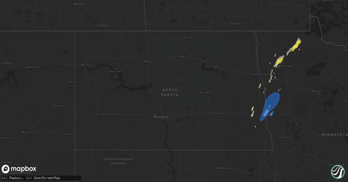
Hail Map in North Dakota on June 8, 2019
Get this storm
June 8 map
$229
one time, instant access
Download today. No call, no setup
Keep the $229
Bought the map and want the full workflow? Apply the entire $229 to a subscription within 7 days. None of it is wasted.
Every map, not just this one
This buys you this map. Subscription and you get every map we run, in the markets you choose from a few cities to whole states to nationwide. Plus real-time alerts the moment a storm fires.
Contact data
Name, contact info, occupancy, even credit band for addresses in the footprint. You go from where it hit to who to call.
Become the source they trust
Unlimited branding weather history reports on demand. You already have the documented answer ready for the property owner, and you are the one who showed up with it.
Property data and RoofTrace estimates
Pull up any address you have got, its value and the exact code rules for that jurisdiction, straight from One Click Code. Then RoofTrace estimates the squares, pitch, and roof value, priced the way you price.
Storm reports in North Dakota
North Dakota
| Date | Description |
|---|---|
| 06/08/20192:08 PM CDT | Peak wind of 65 knots measured at the fargo /kfar/ airport. |
| 06/08/20192:00 PM CDT | A towed camper was blown over on interstate 29 neat 13th ave south exit. Also privacy fencing was blown down acorss portions of south fargo... And some shingles were bl |
| 06/08/20191:38 PM CDT | Large poplar tree branches broken down in shelter belts between mapleton and west fargo. Video posted via social media. |
| 06/08/20191:30 PM CDT | Several large spruce and cottonwood trees were blown down in farmstead shelterbelts along the cass and richland county line. Photos posted via social media. |
| 06/08/20191:25 PM CDT | A local report indicates 1.00 inch wind near 4 WNW AMENIA |
| 06/07/20198:21 PM CDT | At 120 PM CDT, a severe thunderstorm was located near Absaraka, or 24 miles west of Fargo, moving northeast at 25 mph. HAZARD...60 mph wind gusts and quarter size hail. SOURCE...Radar indicated. IMPACT...Hail damage to vehicles is expected. Expect wind damage to roofs, siding, and trees. This severe thunderstorm will be near... Amenia around 125 PM CDT. Arthur around 140 PM CDT. Hunter around 155 PM CDT. Kelso and Blanchard around 215 PM CDT.This includes Interstate 29 between mile markers 98 and 101. |
All States Impacted by Hail Map on June 8, 2019
Cities Impacted by Hail Map on June 8, 2019
- Goodland, KS
- McDonald, KS
- Colby, KS
- Levant, KS
- Longmont, CO
- Boulder, CO
- Lafayette, CO
- Strasburg, CO
- Byers, CO
- Burwell, NE
- Stuart, NE
- Bassett, NE
- Sargent, NE
- Atkinson, NE
- Taylor, NE
- Amelia, NE
- Edson, KS
- Winona, KS
- Brewster, KS
- Glen Elder, KS
- Grinnell, KS
- Ainsworth, NE
- Johnstown, NE
- Tryon, NE
- Seneca, NE
- Ansley, NE
- Anselmo, NE
- Broken Bow, NE
- Westerville, NE
- Comstock, NE
- Merna, NE
- Oberlin, KS
- Franktown, CO
- Castle Rock, CO
- Elizabeth, CO
- Flagler, CO
- Bird City, KS
- Sedalia, CO
- Brady, NE
- Maxwell, NE
- Newfolden, MN
- Viking, MN
- Deer Trail, CO
- Bennett, CO
- Selden, KS
- Wellington, CO
- Wellfleet, NE
- Holbrook, NE
- Bertrand, NE
- Elwood, NE
- Eustis, NE
- Arapahoe, NE
- North Platte, NE
- Atwood, KS
- Cheyenne, WY
- Keenesburg, CO
- Hudson, CO
- Brighton, CO
- Arlington, KS
- Turon, KS
- Cunningham, KS
- Kingman, KS
- Hoxie, KS
- Palisade, NE
- Nekoma, KS
- Saint Francis, KS
- Herndon, KS
- Erie, CO
- Louisville, CO
- Wannaska, MN
- Roseau, MN
- Salol, MN
- Ramah, CO
- Agate, CO
- Stratton, NE
- Trenton, NE
- McCracken, KS
- Matheson, CO
- Limon, CO
- Watkins, CO
- Aurora, CO
- Parker, CO
- Kiowa, CO
- Quinter, KS
- Long Pine, NE
- Hayes Center, NE
- Orleans, NE
- Oxford, NE
- Tipton, KS
- Thief River Falls, MN
- Vidalia, GA
- Lyons, GA
- Grygla, MN
- Elbert, CO
- La Salle, CO
- Simla, CO
- Kenesaw, NE
- Calhan, CO
- Hennessey, OK
- Berthoud, CO
- Platteville, CO
- Mead, CO
- Shickley, NE
- Geneva, NE
- Brownell, KS
- Register, GA
- Vernon, CO
- Wray, CO
- Eckley, CO
- Wallace, KS
- Monument, KS
- Utica, KS
- Morland, KS
- Middle River, MN
- Ord, NE
- Arcadia, NE
- Crookston, MN
- Ames, OK
- Drummond, OK
- Ransom, KS
- Arnold, KS
- Curtis, NE
- Thedford, NE
- Cheyenne Wells, CO
- Carr, CO
- Nunn, CO
- Sutton, NE
- Hudson, KS
- St John, KS
- Collyer, KS
- Wakita, OK
- Nash, OK
- Burlington, OK
- Jet, OK
- Norcatur, KS
- Idalia, CO
- Yuma, CO
- Wakeeney, KS
- Gregory, SD
- Healy, KS
- Dighton, KS
- Gove, KS
- Naper, NE
- Butte, NE
- Scott City, KS
- Norton, KS
- Bonesteel, SD
- Ravenna, NE
- Grover, CO
- Loomis, NE
- Burlington, CO
- Kit Carson, CO
- Hoisington, KS
- Sharon, KS
- Grainfield, KS
- Hays, KS
- Ellis, KS
- Hill City, KS
- Dickens, NE
- Wallace, NE
- Denver, CO
- Thornton, CO
- Henderson, CO
- Abbyville, KS
- Helena, OK
- Edison, NE
- Gothenburg, NE
- Leoti, KS
- McCamey, TX
- Culbertson, NE
- Geneseo, KS
- Commerce City, CO
- Otis, KS
- Olmitz, KS
- Fe Warren Afb, WY
- Farnam, NE
- Moorefield, NE
- Stapleton, NE
- Claflin, KS
- McCook, NE
- Borup, MN
- Georgetown, MN
- Holdrege, NE
- Smithfield, NE
- Cambridge, NE
- Stamford, NE
- Broomfield, CO
- Oakley, KS
- Burke, SD
- Boynton Beach, FL
- Gorham, KS
- Russell, KS
- Penokee, KS
- Ogallah, KS
- Naponee, NE
- Buena Vista, GA
- Cozad, NE
- Englewood, CO
- Littleton, CO
- Raymond, KS
- Pompano Beach, FL
- Coral Springs, FL
- Meno, OK
- Amenia, ND
- Phillipsburg, KS
- Kanorado, KS
- Larned, KS
- Bison, KS
- Carpenter, WY
- Guide Rock, NE
- Blue Hill, NE
- Elm Creek, NE
- Atlanta, NE
- Overton, NE
- Gatzke, MN
- Waldron, KS
- Hazelton, KS
- Kiowa, KS
- Rush Center, KS
- Euclid, MN
- Buxton, ND
- West Palm Beach, FL
- Murdock, KS
- Milton, FL
- Arnold, NE
- Ellinwood, KS
- Miami Gardens, FL
- Opa Locka, FL
- Greenwood, SC
- Ericson, NE
- Beloit, KS
- Wiggins, CO
- Sebring, FL
- Caledonia, ND
- Sylvia, KS
- Stafford, KS
- Platte, SD
- Great Bend, KS
- Wheatland, ND
- Indianola, NE
- Reynolds, ND
- Roggen, CO
- Varnville, SC
- Alma, NE
- Downs, KS
- Portis, KS
- Ness City, KS
- Medicine Lodge, KS
- Hitchcock, SD
- Minden, NE
- Pawnee Rock, KS
- Red Cloud, NE
- Max, NE
- Kersey, CO
- Plevna, KS
- Theodore, AL
- Irvington, AL
- Lake Worth, FL
- Genoa, CO
- Delray Beach, FL
- Boca Raton, FL
- Victoria, KS
- Marienthal, KS
- Fertile, MN
- Pleasanton, NE
- Park, KS
- Benkelman, NE
- Warren, MN
- Doland, SD
- Cherokee, OK
- Waterloo, SC
- Cross Hill, SC
- Chambers, NE
- Bloomington, NE
- Ninety Six, SC
- Holyrood, KS
- Sterling, KS
- Pretty Prairie, KS
- Mills, NE
- Brewster, NE
- Gary, MN
- Nielsville, MN
- Leonard, ND
- North Loup, NE
- Kearney, NE
- Alexander, KS
- Isabel, KS
- Bushton, KS
- Goltry, OK
- Ringwood, OK
- Wauneta, NE
- Schoenchen, KS
- Bazine, KS
- La Crosse, KS
- Bunker Hill, KS
- Dorrance, KS
- Pfeifer, KS
- Liebenthal, KS
- Albert, KS
- Plainville, KS
- Bogue, KS
- Palco, KS
- Funk, NE
- Lone Tree, CO
- Louviers, CO
- Hinesville, GA
- Fort Stewart, GA
- Midway, GA
- Fleming, GA
- Argusville, ND
- Felton, MN
- Horace, ND
- Hendrum, MN
- Fargo, ND
- Halstad, MN
- Ada, MN
- Mapleton, ND
- West Fargo, ND
- Perley, MN
- Glyndon, MN
- Twin Valley, MN
- Ulen, MN
- Moorhead, MN
- Harwood, ND
- Davenport, ND
- Kindred, ND


