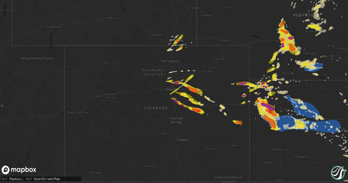
Hail Map on June 8, 2019
Get this storm
June 8 map
$229
one time, instant access
Download today. No call, no setup
Keep the $229
Bought the map and want the full workflow? Apply the entire $229 to a subscription within 7 days. None of it is wasted.
Every map, not just this one
This buys you this map. Subscription and you get every map we run, in the markets you choose from a few cities to whole states to nationwide. Plus real-time alerts the moment a storm fires.
Contact data
Name, contact info, occupancy, even credit band for addresses in the footprint. You go from where it hit to who to call.
Become the source they trust
Unlimited branding weather history reports on demand. You already have the documented answer ready for the property owner, and you are the one who showed up with it.
Property data and RoofTrace estimates
Pull up any address you have got, its value and the exact code rules for that jurisdiction, straight from One Click Code. Then RoofTrace estimates the squares, pitch, and roof value, priced the way you price.
States Impacted by Hail Map on June 8, 2019
Storm reports
Kansas
| Date | Description |
|---|---|
| 06/08/20196:37 PM CDT | Trained spotter reported hail size of 1.61 inches |
| 06/08/20196:35 PM CDT | . |
| 06/08/20196:30 PM CDT | A local report indicates 1.50 inch wind near BREWSTER |
| 06/08/20196:02 PM CDT | A local report indicates 2.00 inch wind near 1 N EDSON |
| 06/08/20195:51 PM CDT | . |
| 06/08/20195:15 PM CDT | A local report indicates 2.00 inch wind near 4 W EDSON |
| 06/08/20195:00 PM CDT | Hail is ongoing. Also spotter says tornado has dissipated. |
| 06/08/20194:55 PM CDT | One landspout tornado went back up into clouds. Another landspout tornado was reported on the ground at 3:55 pm mt. |
| 06/08/20194:55 PM CDT | Hail lasted 15 minutes with the largest hailstones around half dollar size. |
| 06/08/20194:53 PM CDT | Delayed report. While first tornado was ongoing from 3:48 pm storm report... Same spotter saw a second tornado develop at approximately the same location. |
| 06/08/20194:50 PM CDT | Delayed report... Storm chaser reported a landspout tornado saturday afternoon nw of goodland/s of st. Francis... Ks. Report came in via a picture on twitter. |
| 06/08/20194:48 PM CDT | Delayed report. 1st tornado of two. |
| 06/08/20194:40 PM CDT | Delayed report via facebook of pea to quarter size hail. Hail lasted about ten minutes. |
| 06/08/20194:35 PM CDT | Report via facebook. |
| 06/08/20194:28 PM CDT | A local report indicates 1.00 inch wind near 1 NW BREWSTER |
| 06/08/20194:15 PM CDT | Report via facebook of 2 inch hail. |
| 06/08/20196:37 AM CDT | At 1136 PM CDT, a severe thunderstorm was located 4 miles east of Hoxie, moving east at 25 mph. HAZARD...70 mph wind gusts and quarter size hail. SOURCE...Radar indicated. IMPACT...Hail damage to vehicles is expected. Expect considerable tree damage. Wind damage is also likely to mobile homes, roofs, and outbuildings. Locations impacted include... Hill City, Hoxie, Morland, Studley, Penokee, Saint Peter and Tasco. |
| 06/08/20196:34 AM CDT | At 1134 PM CDT, severe thunderstorms were located along a line extending from 6 miles south of Oakley to 15 miles east of Russell Springs to 11 miles west of Scott State Lake, moving east at 50 mph. These are very dangerous storms. HAZARD...80 mph wind gusts and golf ball size hail. SOURCE...Radar indicated. IMPACT...Flying debris will be dangerous to those caught without shelter. Mobile homes will be heavily damaged. Expect considerable damage to roofs, windows, and vehicles. Extensive tree damage and power outages are likely. Locations impacted include... Gove, Monument and The Monument Rocks. |
| 06/08/20196:29 AM CDT | At 1128 PM CDT, severe thunderstorms were located along a line extending from 11 miles north of Scott State Lake to 9 miles northeast of Leoti, moving southeast at 55 mph. These are very dangerous storms. HAZARD...80 mph wind gusts and ping pong ball size hail. SOURCE...Radar indicated. IMPACT...Flying debris will be dangerous to those caught without shelter. Mobile homes will be heavily damaged. Expect considerable damage to roofs, windows, and vehicles. Extensive tree damage and power outages are likely. Locations impacted include... Scott City, Dighton, Grigston, Healy, Friend, Scott State Lake, Modoc, Shallow Water, Manning, Pendennis, Amy and Shields. |
| 06/08/20196:10 AM CDT | At 1110 PM CDT, a severe thunderstorm was located 4 miles south of Selden, or 10 miles northwest of Hoxie, moving east at 40 mph. HAZARD...60 mph wind gusts and half dollar size hail. SOURCE...Radar indicated. IMPACT...Hail damage to vehicles is expected. Expect wind damage to roofs, siding, and trees. Locations impacted include... Hoxie, Selden, Tasco and Seguin. |
| 06/08/20196:03 AM CDT | At 1103 PM CDT, a severe thunderstorm was located near Russell Springs, or 23 miles northwest of Scott State Lake, moving southeast at 40 mph. HAZARD...Two inch hail and 60 mph wind gusts. SOURCE...Radar indicated. IMPACT...People and animals outdoors will be injured. Expect hail damage to roofs, siding, windows, and vehicles. Expect wind damage to roofs, siding, and trees. Locations impacted include... Scott State Lake. |
| 06/08/20195:27 AM CDT | At 1027 PM CDT, a severe thunderstorm was located 8 miles north of Rexford, or 19 miles southwest of Oberlin, moving east at 30 mph. HAZARD...Ping pong ball size hail and 60 mph wind gusts. SOURCE...Radar indicated. IMPACT...People and animals outdoors will be injured. Expect hail damage to roofs, siding, windows, and vehicles. Expect wind damage to roofs, siding, and trees. Locations impacted include... Selden, Jennings, Dresden and Leoville. |
| 06/08/20195:01 AM CDT | At 1001 PM MDT/1101 PM CDT/, a severe thunderstorm was located near Russell Springs, or 21 miles southwest of Oakley, moving southeast at 35 mph. HAZARD...Two inch hail and 60 mph wind gusts. SOURCE...Radar indicated. IMPACT...People and animals outdoors will be injured. Expect hail damage to roofs, siding, windows, and vehicles. Expect wind damage to roofs, siding, and trees. Locations impacted include... Leoti, Sharon Springs, Winona, Wallace, Russell Springs, Selkirk and Marienthal. |
| 06/08/20194:18 AM CDT | At 917 PM MDT/1017 PM CDT/, a severe thunderstorm was located 9 miles north of Wallace, or 14 miles northeast of Sharon Springs, moving southeast at 45 mph. HAZARD...60 mph wind gusts and quarter size hail. SOURCE...Radar indicated. IMPACT...Hail damage to vehicles is expected. Expect wind damage to roofs, siding, and trees. Locations impacted include... Sharon Springs, Winona, Wallace, Russell Springs and Mingo. This includes Interstate 70 in Kansas near mile marker 62. |
| 06/08/20194:10 AM CDT | . |
| 06/08/20194:08 AM CDT | Delayed report from june 9th. Multiple medium size branches down in sw wichita. |
| 06/08/20193:45 AM CDT | At 845 PM MDT, a severe thunderstorm was located 11 miles east of Kit Carson, or 12 miles west of Cheyenne Wells, moving southeast at 55 mph. HAZARD...60 mph wind gusts and quarter size hail. SOURCE...Radar indicated. IMPACT...Hail damage to vehicles is expected. Expect wind damage to roofs, siding, and trees. Locations impacted include... Cheyenne Wells, Arapahoe and Firstview. This includes Highway 385 between mile markers 136 and 158. |
| 06/08/20193:41 AM CDT | At 841 PM MDT/941 PM CDT/, a severe thunderstorm was located 4 miles southeast of Ruleton, moving east at 40 mph. HAZARD...60 mph wind gusts and half dollar size hail. SOURCE...Radar indicated. IMPACT...Hail damage to vehicles is expected. Expect wind damage to roofs, siding, and trees. Locations impacted include... Goodland, Brewster, Ruleton and Edson. This includes Interstate 70 in Kansas between mile markers 6 and 46. |
| 06/08/20193:15 AM CDT | Delayed report...estimated 60-70mph winds. |
| 06/08/20193:13 AM CDT | At 813 PM MDT/913 PM CDT/, a severe thunderstorm was located 15 miles south of Wray, moving east at 25 mph. HAZARD...Ping pong ball size hail and 60 mph wind gusts. SOURCE...Radar indicated. IMPACT...People and animals outdoors will be injured. Expect hail damage to roofs, siding, windows, and vehicles. Expect wind damage to roofs, siding, and trees. Locations impacted include... St. Francis and Beecher Island. |
| 06/08/20193:12 AM CDT | At 812 PM MDT/912 PM CDT/, a severe thunderstorm was located 7 miles north of Winona, or 14 miles south of Levant, moving southeast at 15 mph. HAZARD...70 mph wind gusts and ping pong ball size hail. SOURCE...Radar indicated. IMPACT...People and animals outdoors will be injured. Expect hail damage to roofs, siding, windows, and vehicles. Expect considerable tree damage. Wind damage is also likely to mobile homes, roofs, and outbuildings. Locations impacted include... Oakley, Brewster, Levant, Winona, Monument, Russell Springs and Mingo.This includes Interstate 70 in Kansas between mile markers 27 and 52,and between mile markers 58 and 73. |
| 06/08/20193:08 AM CDT | At 808 PM CDT, a severe thunderstorm was located 4 miles west of Trenton, moving east at 25 mph. HAZARD...Ping pong ball size hail and 60 mph wind gusts. SOURCE...Radar indicated. IMPACT...People and animals outdoors will be injured. Expect hail damage to roofs, siding, windows, and vehicles. Expect wind damage to roofs, siding, and trees. Locations impacted include... McCook, Trenton and Culbertson. |
| 06/08/20192:49 AM CDT | At 749 PM MDT, a severe thunderstorm was located 18 miles south of Eckley, or 19 miles southwest of Wray, moving east at 20 mph. HAZARD...60 mph wind gusts and half dollar size hail. SOURCE...Radar indicated. IMPACT...Hail damage to vehicles is expected. Expect wind damage to roofs, siding, and trees. Locations impacted include... Abarr, Beecher Island, Heartstrong, Idalia and Vernon. This includes Highway 385 between mile markers 209 and 210, andbetween mile markers 212 and 240. |
| 06/08/20192:26 AM CDT | At 725 PM MDT/825 PM CDT/, a severe thunderstorm was located 5 miles west of Brewster, moving southeast at 35 mph. This is a very dangerous storm. HAZARD...80 mph wind gusts and tennis ball size hail. SOURCE...Trained spotter reported tennis ball size hail and a rotating wall cloud. IMPACT...Flying debris will be dangerous to those caught without shelter. Mobile homes will be heavily damaged. Expect considerable damage to roofs, windows, and vehicles. Extensive tree damage and power outages are likely. Locations impacted include... Brewster, Winona and Edson. This includes Interstate 70 in Kansas between mile markers 22 and 47. |
| 06/08/20192:10 AM CDT | . |
| 06/08/20192:06 AM CDT | Asos station krsl russell municipal airport. |
| 06/08/20191:41 AM CDT | At 641 PM MDT/741 PM CDT/, a severe thunderstorm was located 5 miles west of Brewster, moving east at 20 mph. HAZARD...Ping pong ball size hail and 60 mph wind gusts. SOURCE...Radar indicated. IMPACT...People and animals outdoors will be injured. Expect hail damage to roofs, siding, windows, and vehicles. Expect wind damage to roofs, siding, and trees. Locations impacted include... Brewster, Levant and Edson. This includes Interstate 70 in Kansas between mile markers 22 and 48. |
| 06/08/20191:00 AM CDT | At 600 PM MDT/700 PM CDT/, a severe thunderstorm was located 9 miles northeast of Goodland, moving northeast at 20 mph. HAZARD...Ping pong ball size hail and 60 mph wind gusts. SOURCE...Trained weather spotters. IMPACT...People and animals outdoors will be injured. Expect hail damage to roofs, siding, windows, and vehicles. Expect wind damage to roofs, siding, and trees. Locations impacted include... Goodland and Edson. This includes Interstate 70 in Kansas between mile markers 19 and 35. |
| 06/08/201912:40 AM CDT | Mesonet station k5wky 1 ssw wakeeney. |
| 06/08/201912:35 AM CDT | At 535 PM MDT, a severe thunderstorm was located near Goodland, moving northeast at 20 mph. HAZARD...60 mph wind gusts and quarter size hail. SOURCE...Radar indicated. IMPACT...Hail damage to vehicles is expected. Expect wind damage to roofs, siding, and trees. Locations impacted include... Goodland.This includes Interstate 70 in Kansas between mile markers 15 and 23. |
| 06/08/201912:20 AM CDT | Mesonet station dw2812 scott city. |
| 06/08/201912:09 AM CDT | . |
| 06/07/201911:53 PM CDT | At 453 PM MDT/553 PM CDT/, a severe thunderstorm was located 13 miles south of St. Francis, moving east at 35 mph. HAZARD...60 mph wind gusts and half dollar size hail. SOURCE...Radar indicated. IMPACT...Hail damage to vehicles is expected. Expect wind damage to roofs, siding, and trees. Locations impacted include... Bird City. |
| 06/07/201911:35 PM CDT | One half mile east and one quarter mile north of hoxie. Peak gust 102.7 measured. 40 foot tv tower kinked in half. 6 inch branches snapped off. Live 10 to 12 inch pine |
| 06/07/201911:29 PM CDT | . |
| 06/07/201910:58 PM CDT | At 357 PM CDT, a severe thunderstorm was located 11 miles southwest of Benkelman, moving east at 10 mph. HAZARD...Ping pong ball size hail and 60 mph wind gusts. SOURCE...Radar indicated. IMPACT...People and animals outdoors will be injured. Expect hail damage to roofs, siding, windows, and vehicles. Expect wind damage to roofs, siding, and trees. Locations impacted include... St. Francis and Wheeler. |
| 06/07/201910:45 PM CDT | . |
| 06/07/201910:44 PM CDT | At 344 PM MDT/444 PM CDT/, a severe thunderstorm was located 6 miles southwest of St. Francis, moving northeast at 25 mph. HAZARD...Two inch hail and 70 mph wind gusts. SOURCE...Trained weather spotters. IMPACT...People and animals outdoors will be injured. Expect hail damage to roofs, siding, windows, and vehicles. Expect considerable tree damage. Wind damage is also likely to mobile homes, roofs, and outbuildings. Locations impacted include... St. Francis, Benkelman, Bird City and Wheeler. |
| 06/07/201910:09 PM CDT | At 309 PM MDT, a severe thunderstorm was located 6 miles southwest of Bonny Reservoir, moving northeast at 10 mph. HAZARD...60 mph wind gusts and half dollar size hail. SOURCE...Radar indicated. IMPACT...Hail damage to vehicles is expected. Expect wind damage to roofs, siding, and trees. Locations impacted include... Bonny Reservoir and Hale. This includes Highway 385 between mile markers 200 and 216. |
| 06/07/201910:05 PM CDT | . |
| 06/07/20199:55 PM CDT | Winona has lost power. Unknown whether from straightline winds or tornado. |
| 06/07/20199:50 PM CDT | . |
| 06/07/20199:45 PM CDT | Delayed report via social media. |
| 06/07/20199:30 PM CDT | Delayed report via social media. |
| 06/07/20199:30 PM CDT | Delayed report via facebook. |
| 06/07/20199:25 PM CDT | Storm chaser posted a picture on twitter of a possible tornado touchdown near the us40/cr220 intersection sw of winona... Ks at 2125 cdt. |
| 06/07/20199:19 PM CDT | . |
| 06/07/20199:08 PM CDT | . |
| 06/07/20199:02 PM CDT | . |
| 06/07/20199:00 PM CDT | Delayed report via social media. |
| 06/07/20198:55 PM CDT | . |
| 06/07/20198:51 PM CDT | Report from near the brewster exit on i70. |
| 06/07/20198:47 PM CDT | . |
| 06/07/20198:30 PM CDT | . |
| 06/07/20198:30 PM CDT | Corrects previous hail report from brewster. Report from near the brewster exit on i70. Corrected the previous report to correct the time of the report. |
| 06/07/20198:15 PM CDT | Public reported wind damage in edson last night with trees and power lines damaged. Public reported possibly caused by tornado. Public reported time as in the evening o |
| 06/07/20198:10 PM CDT | This is on road 29 south of edson. |
| 06/07/20198:10 PM CDT | Mesonet report of 60 mph wind gust. |
| 06/07/20198:00 PM CDT | Public reported via facebook golf ball to tennis ball size hail around 7 pm mdt at the overpass near mm 25 along i-70. |
Nebraska
| Date | Description |
|---|---|
| 06/08/20196:20 PM CDT | A local report indicates 1.00 inch wind near 5 W BRADY |
| 06/08/20195:54 PM CDT | A local report indicates 1.25 inch wind near 2 S NORTH PLATTE |
| 06/08/20195:50 PM CDT | . |
| 06/08/20195:48 PM CDT | A local report indicates 1.75 inch wind near 2 S NORTH PLATTE |
| 06/08/20195:37 PM CDT | A local report indicates 1.00 inch wind near NORTH PLATTE |
| 06/08/20195:35 PM CDT | Corrects previous hail report from north platte. |
| 06/08/20195:30 PM CDT | Reported at bailey yard. At least four automotive windshields cracked... Report of broken tail lights and broken side mirrors. |
| 06/08/20195:27 PM CDT | A local report indicates 1.00 inch wind near 12 NE NORTH PLATTE |
| 06/08/20195:26 PM CDT | A local report indicates 1.00 inch wind near 15 NNE NORTH PLATTE |
| 06/08/20195:25 PM CDT | A local report indicates 58 MPH wind near 4 N NORTH PLATTE |
| 06/08/20195:24 PM CDT | Reported at bailey yard. At least four automotive windshields cracked... Report of broken tail lights and broken side mirrors. |
| 06/08/20194:55 PM CDT | Delayed report. Rancher called in to report ping pong sized hail at onset of hail. Time estimated from radar. |
| 06/08/20194:45 PM CDT | A local report indicates 1.50 inch wind near 18 NNW NORTH PLATTE |
| 06/08/20194:31 PM CDT | A local report indicates 1.00 inch wind near 9 SE TRYON |
| 06/08/20193:40 PM CDT | A local report indicates 1.00 inch wind near 4 NE TRYON |
| 06/08/20195:06 AM CDT | At 1005 PM CDT, severe thunderstorms were located along a line extending from near Hastings to Roseland to near Bladen, moving east at 25 mph. HAZARD...60 mph wind gusts. SOURCE...Radar indicated. IMPACT...Expect damage to roofs, siding, and trees. Locations impacted include... Hastings, Roseland, Holstein and Ayr. |
| 06/08/20194:43 AM CDT | At 942 PM CDT, a severe thunderstorm was located 11 miles southeast of McDonald, or 17 miles southwest of Atwood, moving northeast at 35 mph. HAZARD...Ping pong ball size hail and 60 mph wind gusts. SOURCE...Radar indicated. IMPACT...People and animals outdoors will be injured. Expect hail damage to roofs, siding, windows, and vehicles. Expect wind damage to roofs, siding, and trees. Locations impacted include... Atwood, McDonald, Herndon, Danbury, Ludell, Blakeman and Traer. |
| 06/08/20194:01 AM CDT | At 901 PM CDT, severe thunderstorms were located along a line extending from near Funk to near Wilcox to 6 miles southwest of Ragan, moving east at 40 mph. HAZARD...60 mph wind gusts. SOURCE...Radar indicated. IMPACT...Expect damage to roofs, siding, and trees. Locations impacted include... Minden, Axtell, Hildreth, Wilcox, Campbell, Funk, Upland, Heartwell and Norman. |
| 06/08/20193:55 AM CDT | At 854 PM CDT, severe thunderstorms were located along a line extending from 4 miles south of Culbertson to 4 miles west of McDonald, moving southeast at 20 mph. HAZARD...70 mph wind gusts and ping pong ball size hail. SOURCE...Radar indicated. IMPACT...People and animals outdoors will be injured. Expect hail damage to roofs, siding, windows, and vehicles. Expect considerable tree damage. Wind damage is also likely to mobile homes, roofs, and outbuildings. Locations impacted include... Atwood, Trenton, Bird City, McDonald, Blakeman and Beardsley. |
| 06/08/20193:44 AM CDT | At 844 PM CDT, severe thunderstorms were located along a line extending from near Loomis to Atlanta to Oxford, moving southeast at 15 mph. HAZARD...70 mph wind gusts and nickel size hail. SOURCE...Radar indicated. IMPACT...Expect considerable tree damage. Damage is likely to mobile homes, roofs, and outbuildings. Locations impacted include... Holdrege, Alma, Oxford, Bertrand, Orleans, Loomis, Funk, Stamford, Republican City, Atlanta, Huntley, Ragan, Hollinger and Harlan County Dam. |
| 06/08/20193:41 AM CDT | At 841 PM CDT, a severe thunderstorm was located 8 miles north of McDonald, or 14 miles southeast of Benkelman, moving east at 30 mph. HAZARD...Ping pong ball size hail and 60 mph wind gusts. SOURCE...Radar indicated. IMPACT...People and animals outdoors will be injured. Expect hail damage to roofs, siding, windows, and vehicles. Expect wind damage to roofs, siding, and trees. Locations impacted include... Bird City, McDonald, Blakeman, Beardsley and Wheeler. |
| 06/08/20193:29 AM CDT | At 828 PM CDT, a severe thunderstorm was located over Weissert, or 11 miles east of Broken Bow, moving southeast at 25 mph. HAZARD...60 mph wind gusts and quarter size hail. SOURCE...Radar indicated. IMPACT...Hail damage to vehicles is expected. Expect wind damage to roofs, siding, and trees. Locations impacted include... Ansley, Mason City, Comstock, Weissert, Westerville, Arcadia Diversion Dam State Wildlife Management Area, Gavin Siding and Wescott.This includes the following highways... Highway 183 between mile markers 88 and 109. Highway 2 between mile markers 291 and 307. Highway 92 between mile markers 300 and 308. |
| 06/08/20193:13 AM CDT | At 812 PM CDT, a severe thunderstorm was located 8 miles north of Edison, or 21 miles west of Holdrege, moving east at 40 mph. HAZARD...60 mph wind gusts and nickel size hail. SOURCE...Radar indicated. IMPACT...Expect damage to roofs, siding, and trees. Locations impacted include... Holdrege, Arapahoe, Bertrand, Loomis and Atlanta. |
| 06/08/20192:52 AM CDT | At 752 PM CDT, a severe thunderstorm was located near Merna, or 9 miles north of Broken Bow, moving east at 20 mph. HAZARD...60 mph wind gusts and quarter size hail. SOURCE...Radar indicated. IMPACT...Hail damage to vehicles is expected. Expect wind damage to roofs, siding, and trees. Locations impacted include... Merna, Comstock, Weissert, Westerville, Lillian, Round Valley, Arcadia Diversion Dam State Wildlife Management Area and Wescott.This includes the following highways... Highway 183 between mile markers 95 and 112. Highway 2 between mile markers 267 and 270. Highway 92 near mile marker 273. |
| 06/08/20192:12 AM CDT | At 712 PM CDT, severe thunderstorms were located along a line extending from Gothenburg to 11 miles northwest of Eustis, moving southeast at 25 mph. HAZARD...60 mph wind gusts and half dollar size hail. SOURCE...Radar indicated. IMPACT...Hail damage to vehicles is expected. Expect wind damage to roofs, siding, and trees. Locations impacted include... Cozad, Gothenburg, Willow Island and Farnam. This includes Interstate 80 between mile markers 209 and 234. |
| 06/08/20191:41 AM CDT | At 641 PM CDT, a severe thunderstorm was located 9 miles southwest of Gothenburg, or 18 miles northeast of Curtis, moving southeast at 25 mph. HAZARD...Ping pong ball size hail and 60 mph wind gusts. SOURCE...Radar indicated. IMPACT...People and animals outdoors will be injured. Expect hail damage to roofs, siding, windows, and vehicles. Expect wind damage to roofs, siding, and trees. Locations impacted include... Cozad, Gothenburg, Willow Island and Farnam. This includes Interstate 80 between mile markers 209 and 222. |
| 06/08/20191:13 AM CDT | At 613 PM CDT, severe thunderstorms were located along a line extending from 12 miles southwest of Callaway to near Brady to near Wellfleet to 10 miles south of Dickens, moving southeast at 30 mph. HAZARD...60 mph wind gusts and half dollar size hail. SOURCE...Radar indicated. IMPACT...Hail damage to vehicles is expected. Expect wind damage to roofs, siding, and trees. Locations impacted include... Curtis, Hayes Center, Brady, Eustis, Wellfleet, Moorefield, Stockville, Dickens, Maywood, Quick, Cottonwood Canyon State Wildlife Management Area, Etna, Hansen Memorial Reserve State Wildlife Management Area, Jeffrey Canyon State Wildlife Management Area, Hayes Center State Wildlife Management Area, Marengo, Vroman, Somerset and Dancing Leaf Earth Lodge.This includes the following highways... Interstate 80 in Nebraska between mile markers 192 and 207. Highway 83 between mile markers 30 and 69. |
| 06/08/201912:59 AM CDT | At 559 PM CDT, severe thunderstorms were located along a line extending from 10 miles northeast of Brady to 11 miles northeast of Wellfleet, moving southeast at 30 mph. HAZARD...60 mph wind gusts and half dollar size hail. SOURCE...Radar indicated. IMPACT...Hail damage to vehicles is expected. Expect wind damage to roofs, siding, and trees. Locations impacted include... Cozad, Gothenburg, Willow Island and Farnam. This includes Interstate 80 between mile markers 209 and 232. |
| 06/08/201912:37 AM CDT | At 537 PM CDT, a severe thunderstorm was located 6 miles southwest of Palisade, or 13 miles northwest of Trenton, moving northeast at 25 mph. HAZARD...60 mph wind gusts and half dollar size hail. SOURCE...Radar indicated. IMPACT...Hail damage to vehicles is expected. Expect wind damage to roofs, siding, and trees. Locations impacted include... Palisade. |
| 06/08/201912:17 AM CDT | At 516 PM CDT, severe thunderstorms were located along a line extending from near Gandy to near Hershey, moving southeast at 20 mph. HAZARD...Ping pong ball size hail and 60 mph wind gusts. SOURCE...Radar indicated. IMPACT...People and animals outdoors will be injured. Expect hail damage to roofs, siding, windows, and vehicles. Expect wind damage to roofs, siding, and trees. Locations impacted include... North Platte, Hershey, Brady, Maxwell, Wellfleet, Gandy, Lake Maloney State Recreation Area, North Platte Airport, Keith, Cottonwood Canyon State Wildlife Management Area, Etna, Jeffrey Canyon State Wildlife Management Area, Birdwood and Somerset.This includes the following highways... Highway 92 between mile markers 233 and 243. Highway 97 between mile markers 1 and 7. Interstate 80 in Nebraska between mile markers 161 and 203. Highway 83 between mile markers 57 and 110. |
| 06/07/201911:44 PM CDT | At 443 PM CDT, a severe thunderstorm was located 7 miles south of Ringgold, or 13 miles southeast of Tryon, moving southeast at 10 mph. HAZARD...Ping pong ball size hail and 60 mph wind gusts. SOURCE...Radar indicated. IMPACT...People and animals outdoors will be injured. Expect hail damage to roofs, siding, windows, and vehicles. Expect wind damage to roofs, siding, and trees. Locations impacted include... North Platte and Ringgold. This includes the following highways... Highway 92 between mile markers 212 and 224. Highway 97 between mile markers 1 and 22. Highway 83 between mile markers 85 and 107. |
| 06/07/201911:15 PM CDT | At 415 PM CDT, a severe thunderstorm was located near Ringgold, or near Tryon, moving east at 10 mph. HAZARD...60 mph wind gusts and quarter size hail. SOURCE...Radar indicated. IMPACT...Hail damage to vehicles is expected. Expect wind damage to roofs, siding, and trees. Locations impacted include... Ringgold.This includes the following highways... Highway 92 between mile markers 206 and 224. Highway 97 between mile markers 18 and 26. |
| 06/07/201910:34 PM CDT | At 334 PM CDT, a severe thunderstorm was located 7 miles north of Ringgold, or 7 miles northeast of Tryon, moving northeast at 10 mph. HAZARD...60 mph wind gusts and half dollar size hail. SOURCE...Radar indicated. IMPACT...Hail damage to vehicles is expected. Expect wind damage to roofs, siding, and trees. Locations impacted include... Tryon and Ringgold. This includes the following highways... Highway 92 between mile markers 203 and 215. Highway 97 between mile markers 26 and 39. Highway 83 near mile marker 120. |
| 06/07/201910:30 PM CDT | Estimated 55-60 mph winds. Winds were strong for about 5-7 minutes. |
| 06/07/20199:01 PM CDT | Delayed report. |
| 06/07/20198:57 PM CDT | A local report indicates 61 MPH wind near HOLDREGE AIRPORT |
| 06/07/20198:55 PM CDT | Power was lost in part of town... Sparks were reported at a substation. 4 power poles were damaged near 18th ave. And lincoln st. A large tree was downed at the cemeter |
| 06/07/20198:50 PM CDT | A local report indicates 63 MPH wind near 1 NW HOLDREGE |
| 06/07/20198:47 PM CDT | A local report indicates 60 MPH wind near 4 NNE OXFORD |
| 06/07/20198:46 PM CDT | A local report indicates 70 MPH wind near 3 SSE LOOMIS |
| 06/07/20198:45 PM CDT | Wind gusts estimated to be at least 70 mph. |
| 06/07/20198:43 PM CDT | A local report indicates 58 MPH wind near 3 WNW HOLDREGE |
| 06/07/20198:40 PM CDT | A local report indicates 58 MPH wind near 1 ESE LOOMIS |
| 06/07/20198:39 PM CDT | A local report indicates 60 MPH wind near ATLANTA |
| 06/07/20198:36 PM CDT | A local report indicates 70 MPH wind near 1 N OXFORD |
| 06/07/20198:30 PM CDT | Delayed report. |
| 06/07/20198:30 PM CDT | A local report indicates 64 MPH wind near 6 WNW ATLANTA |
| 06/07/20198:14 PM CDT | Measured on handheld anemometer. |
| 06/07/20198:11 PM CDT | Wind measured on a hand held anemometer. |
| 06/07/20198:09 PM CDT | Report of power pole/power line damage in town. Power line lying across the hwy 34/283 junction. Tree limbs of 6-8 inches downed. This spotter measured a 73 mph wind on |
| 06/07/20197:54 PM CDT | A local report indicates 1.00 inch wind near 3 NE MERNA |
North Carolina
| Date | Description |
|---|---|
| 06/08/20194:10 PM CDT | Apparent tornado downed several trees along webb rd. No structural damage reported. |
South Carolina
| Date | Description |
|---|---|
| 06/08/20192:50 PM CDT | Schp reported trees down on roadway near joneswire road and martin neese road in lexington county. Time approximated by radar. |
| 06/08/20191:12 PM CDT | Sc highway patrol reported a tree down. Time estimated by radar. |
| 06/08/20193:10 AM CDT | At 809 PM EDT, a severe thunderstorm was located over Graniteville, or near Aiken, moving northeast at 30 mph. HAZARD...60 mph wind gusts. SOURCE...Radar indicated. IMPACT...Expect damage to roofs, siding, and trees. Locations impacted include... Aiken, Aiken Mall, New Ellenton, USC Aiken, Aiken Municipal Airport, Citizens Park, Gloverville, Edgefield County Airport, Graniteville, Burnettown, Wagener, Monetta, Vaucluse, New Holland and Murphy Village. |
| 06/08/20192:42 AM CDT | At 742 PM EDT, a severe thunderstorm was located 8 miles south of Springfield, moving northeast at 30 mph. HAZARD...60 mph wind gusts. SOURCE...Radar indicated. IMPACT...Expect damage to trees and powerlines. Locations impacted include... Savannah, Pooler, Bluffton, Ridgeland, Springfield, I-16/I-95 Interchange, Jasper and Rincon.This warning includes... I-16 between mile markers 149 and 160. I-95 in South Carolina between mile markers 2 and 25. I-95 in Georgia between mile markers 97 and 112. |
| 06/07/201911:28 PM CDT | At 428 PM EDT, a severe thunderstorm was located near Fort Gordon, moving northeast at 15 mph. HAZARD...60 mph wind gusts and penny size hail. SOURCE...Radar indicated. IMPACT...Expect damage to roofs, siding, and trees. Locations impacted include... North Augusta, Grovetown, Evans, Martinez, Fort Gordon, Augusta, Belvedere, Clearwater, Hephzibah, Glendale, South Augusta, Midtown, Summerville, Augusta Mall, Daniel Field, Augusta Regional Airport, Village Plaza Shopping Center, Augusta National Golf Club, Blythe and West End Augusta. |
| 06/07/201910:55 PM CDT | At 353 PM EDT, severe thunderstorms were located along a line extending from 11 miles southeast of Batesburg-Leesville to near Gaston, moving north at 30 mph. HAZARD...60 mph wind gusts and penny size hail. SOURCE...Radar indicated. IMPACT...Expect damage to roofs, siding, and trees. Locations impacted include... Columbia, Lexington, West Columbia, Cayce, Irmo, Forest Acres, Batesburg-Leesville, Springdale, St. Andrews, Dentsville, Lake Murray Dam, Oak Grove, Red Bank, South Congaree, Pine Ridge, Gaston, Prosperity, Arcadia Lakes, Columbia International University and Harbison State Forest. |
| 06/07/201910:25 PM CDT | At 324 PM EDT, a severe thunderstorm was located 12 miles north of Blackville, or 15 miles north of Denmark, moving north at 25 mph. HAZARD...60 mph wind gusts and quarter size hail. SOURCE...Radar indicated. IMPACT...Hail damage to vehicles is expected. Expect wind damage to roofs, siding, and trees. Locations impacted include... Swansea, Wagener, North, Pelion, Springfield, Salley, Neeses, Norway, Perry, Woodford, Livingston, Perry Airport and Thor. |
| 06/07/20197:25 PM CDT | Tree down near the intersection of calf pen bay road and firetower road. Time estimated by radar. |
Colorado
| Date | Description |
|---|---|
| 06/08/20196:55 PM CDT | A local report indicates 1.00 inch wind near 2 W AURORA |
| 06/08/20196:49 PM CDT | Corrects time of previous hail report from 1 n castle rock. |
| 06/08/20196:47 PM CDT | Corrects time of previous hail report from 2 nnw castle rock. |
| 06/08/20196:45 PM CDT | A local report indicates 1.00 inch wind near CASTLE ROCK |
| 06/08/20196:15 PM CDT | A local report indicates 1.00 inch wind near 4 NNE DENVER INTL AIRPO |
| 06/08/20196:11 PM CDT | A local report indicates 1.50 inch wind near BRIGHTON |
| 06/08/20196:05 PM CDT | A local report indicates 1.00 inch wind near 3 S BARR LAKE |
| 06/08/20195:55 PM CDT | A local report indicates 1.00 inch wind near 2 NE HENDERSON |
| 06/08/20195:25 PM CDT | A local report indicates 1.00 inch wind near 3 ENE BROOMFIELD |
| 06/08/20194:58 PM CDT | A local report indicates 1.00 inch wind near LOUISVILLE |
| 06/08/20194:55 PM CDT | A local report indicates 1.25 inch wind near 2 SSE ERIE |
| 06/08/20194:50 PM CDT | A local report indicates 1.00 inch wind near 2 S LAFAYETTE |
| 06/08/20194:39 PM CDT | Public reported 1 hail over hwy 385. Time estimated based on radar. |
| 06/08/20194:12 PM CDT | Public report via facebook of a landspout. |
| 06/08/20193:00 PM CDT | Landspout tornado reported. Has since dissipated. |
| 06/08/20193:43 AM CDT | At 842 PM MDT, a severe thunderstorm was located near Platteville, or 12 miles southwest of Greeley, moving east at 40 mph. HAZARD...Quarter size hail. SOURCE...Radar indicated. IMPACT...Damage to vehicles is expected. Locations impacted include... Southeastern Greeley, Evans, Milliken, Platteville, LaSalle, Kersey, Gilcrest, Gill and Milton Reservoir. |
| 06/08/20193:05 AM CDT | At 805 PM MDT, severe thunderstorms were located along a line extending from 5 miles southeast of Flagler to 8 miles northeast of Boyero, moving southeast at 40 mph. HAZARD...70 mph wind gusts and quarter size hail. SOURCE...Radar indicated. IMPACT...Hail damage to vehicles is expected. Expect considerable tree damage. Wind damage is also likely to mobile homes, roofs, and outbuildings. Locations impacted include... Flagler, Kit Carson, Firstview and Wild Horse. This includes Interstate 70 in Colorado between mile markers 394 and403. |
| 06/08/20192:42 AM CDT | At 742 PM MDT, a severe thunderstorm was located 12 miles northeast of Kutch, or 14 miles south of Limon, moving southeast at 30 mph. HAZARD...60 mph wind gusts and half dollar size hail. SOURCE...Radar indicated. IMPACT...Expect damage to roofs, siding, and trees. Hail damage to vehicles is expected. Locations impacted include... Hugo. |
| 06/08/20192:37 AM CDT | At 737 PM MDT, a severe thunderstorm was located 4 miles southeast of Arriba, or 8 miles southwest of Flagler, moving southeast at 30 mph. HAZARD...60 mph wind gusts and quarter size hail. SOURCE...Radar indicated. IMPACT...Hail damage to vehicles is expected. Expect wind damage to roofs, siding, and trees. Locations impacted include... Flagler and Seibert. This includes Interstate 70 in Colorado between mile markers 391 and408. |
| 06/08/20192:09 AM CDT | At 709 PM MDT, a severe thunderstorm was located near Simla, or 21 miles southwest of Limon, moving southeast at 35 mph. HAZARD...Ping pong ball size hail and 60 mph wind gusts. SOURCE...Radar indicated. IMPACT...Expect damage to roofs, siding, and trees. People and animals outdoors will be injured. Expect hail damage to roofs, siding, windows, and vehicles. Locations impacted include... Simla and Matheson. |
| 06/08/20192:00 AM CDT | At 700 PM MDT, a severe thunderstorm was located 7 miles east of Prospect Valley, or 27 miles southwest of Fort Morgan, moving northeast at 40 mph. HAZARD...60 mph wind gusts and half dollar size hail. SOURCE...Radar indicated. IMPACT...Expect damage to roofs, siding, and trees. Hail damage to vehicles is expected. Locations impacted include... Wiggins and Orchard. |
| 06/08/20191:55 AM CDT | At 655 PM MDT, a severe thunderstorm was located 11 miles southeast of Cottonwood Valley, or 16 miles north of Limon, moving southeast at 30 mph. HAZARD...70 mph wind gusts and ping pong ball size hail. SOURCE...Radar indicated. IMPACT...Expect considerable tree damage. Damage is likely to mobile homes, roofs, and outbuildings. People and animals outdoors will be injured. Expect hail damage to roofs, siding, windows, and vehicles. Locations impacted include... Genoa. |
| 06/08/20191:46 AM CDT | At 646 PM MDT, a severe thunderstorm was located 5 miles northwest of Ramah, or 30 miles west of Limon, moving southeast at 40 mph. HAZARD...Ping pong ball size hail and 60 mph wind gusts. SOURCE...Radar indicated. IMPACT...Expect damage to roofs, siding, and trees. People and animals outdoors will be injured. Expect hail damage to roofs, siding, windows, and vehicles. This severe thunderstorm will remain over mainly rural areas of central Elbert County. |
| 06/08/20191:33 AM CDT | At 633 PM MDT, a severe thunderstorm was located 9 miles east of Denver International Airport, or 27 miles northeast of Denver, moving northeast at 40 mph. HAZARD...Ping pong ball size hail and 60 mph wind gusts. SOURCE...Radar indicated. IMPACT...Expect damage to roofs, siding, and trees. People and animals outdoors will be injured. Expect hail damage to roofs, siding, windows, and vehicles. Locations impacted include... Prospect Valley. |
| 06/08/20191:28 AM CDT | At 628 PM MDT, a severe thunderstorm was located 4 miles west of Cottonwood Valley, or 29 miles north of Limon, moving southeast at 35 mph. HAZARD...Ping pong ball size hail and 60 mph wind gusts. SOURCE...Radar indicated. IMPACT...Expect damage to roofs, siding, and trees. People and animals outdoors will be injured. Expect hail damage to roofs, siding, windows, and vehicles. Locations impacted include... Cottonwood Valley. |
| 06/08/20191:24 AM CDT | At 624 PM MDT, a severe thunderstorm was located 12 miles northeast of Kiowa, or 33 miles northwest of Limon, moving southeast at 55 mph. HAZARD...60 mph wind gusts and half dollar size hail. SOURCE...Radar indicated. IMPACT...Expect damage to roofs, siding, and trees. Hail damage to vehicles is expected. This severe thunderstorm will remain over mainly rural areas of north central Elbert County. |
| 06/08/20191:11 AM CDT | At 611 PM MDT, a severe thunderstorm was located near Elizabeth, or 32 miles southeast of Denver, moving east at 30 mph. HAZARD...60 mph wind gusts and half dollar size hail. SOURCE...Radar indicated. IMPACT...Expect damage to roofs, siding, and trees. Hail damage to vehicles is expected. Locations impacted include... Elbert, Elizabeth, Kiowa and Ponderosa Park. |
| 06/08/201912:58 AM CDT | At 558 PM MDT, a severe thunderstorm was located near Byers, or 41 miles northwest of Limon, moving southeast at 45 mph. HAZARD...Ping pong ball size hail and 60 mph wind gusts. SOURCE...Radar indicated. IMPACT...Expect damage to roofs, siding, and trees. People and animals outdoors will be injured. Expect hail damage to roofs, siding, windows, and vehicles. Locations impacted include... Deer Trail, Strasburg and Byers. |
| 06/08/201912:48 AM CDT | At 548 PM MDT, a severe thunderstorm was located 6 miles southeast of Arapahoe Park, or 24 miles southeast of Denver, moving east at 35 mph. HAZARD...Ping pong ball size hail and 60 mph wind gusts. SOURCE...Radar indicated. IMPACT...Expect damage to roofs, siding, and trees. People and animals outdoors will be injured. Expect hail damage to roofs, siding, windows, and vehicles. This severe thunderstorm will remain over mainly rural areas of northwestern Elbert and south central Arapahoe Counties. |
| 06/08/201912:45 AM CDT | At 545 PM MDT, a severe thunderstorm was located over southern Denver, moving northeast at 35 mph. HAZARD...60 mph wind gusts and quarter size hail. SOURCE...Radar indicated. IMPACT...Expect damage to roofs, siding, and trees. Hail damage to vehicles is expected. Locations impacted include... Denver, Aurora, Centennial, northern Highlands Ranch, northeastern Littleton, Englewood, Greenwood Village, Denver International Airport, D.I.A Terminal and Concourses, Sheridan, Watkins and Buckley AFB. |
| 06/08/201912:44 AM CDT | At 544 PM MDT, a severe thunderstorm was located near Castle Pines, or 21 miles southeast of Denver, moving east at 35 mph. HAZARD...Ping pong ball size hail and 60 mph wind gusts. SOURCE...Radar indicated. IMPACT...Expect damage to roofs, siding, and trees. People and animals outdoors will be injured. Expect hail damage to roofs, siding, windows, and vehicles. Locations impacted include... Castle Rock, Parker, Franktown, The Pinery and southeastern Castle Pines. |
| 06/08/201912:25 AM CDT | At 525 PM MDT, a severe thunderstorm was located 7 miles northeast of Denver International Airport, or 25 miles northeast of Denver, moving east at 25 mph. HAZARD...Ping pong ball size hail. SOURCE...Radar indicated. IMPACT...People and animals outdoors will be injured. Expect damage to roofs, siding, windows, and vehicles. This severe thunderstorm will remain over mainly rural areas of central Adams County. |
| 06/08/201912:22 AM CDT | At 522 PM MDT, a severe thunderstorm was located 4 miles south of Keenesburg, or 28 miles south of Greeley, moving east at 35 mph. HAZARD...Half dollar size hail. SOURCE...Radar indicated. IMPACT...Damage to vehicles is expected. Locations impacted include... Hudson, Keenesburg, Prospect Valley and Roggen. |
| 06/07/201911:58 PM CDT | At 457 PM MDT, a severe thunderstorm was located over Barr Lake, or 16 miles northeast of Denver, moving east at 30 mph. HAZARD...Half dollar size hail. SOURCE...Radar indicated. IMPACT...Damage to vehicles is expected. Locations impacted include... Northeastern Commerce City, Brighton, Denver International Airport, D.I.A Terminal and Concourses and Barr Lake. |
| 06/07/201911:35 PM CDT | At 434 PM MDT, a severe thunderstorm was located 4 miles north of Erie, or 24 miles north of Denver, moving east at 35 mph. HAZARD...Ping pong ball size hail and 60 mph wind gusts. SOURCE...Radar indicated. IMPACT...Expect damage to roofs, siding, and trees. People and animals outdoors will be injured. Expect hail damage to roofs, siding, windows, and vehicles. Locations impacted include... Thornton, northeastern Westminster, Broomfield, northern Northglenn, Brighton, Lafayette, Louisville, Erie, Firestone, Frederick, Fort Lupton, Lochbuie, Dacono, Barr Lake, Todd Creek and Niwot. |
| 06/07/201910:39 PM CDT | At 339 PM MDT, a severe thunderstorm was located over Lafayette, or 18 miles northwest of Denver, moving east at 15 mph. HAZARD...60 mph wind gusts and quarter size hail. SOURCE...Radar indicated. IMPACT...Expect damage to roofs, siding, and trees. Hail damage to vehicles is expected. Locations impacted include... Northern Thornton, northeastern Westminster, Broomfield, Lafayette, Louisville, Erie, Superior and Todd Creek. |
| 06/07/20199:52 PM CDT | . |
| 06/07/20199:47 PM CDT | At 247 PM MDT, a severe thunderstorm was located 4 miles north of Kanorado, moving east at 20 mph. HAZARD...60 mph wind gusts and quarter size hail. SOURCE...Radar indicated. IMPACT...Hail damage to vehicles is expected. Expect wind damage to roofs, siding, and trees. Locations impacted include... Kanorado and Ruleton. This includes the following highways... Interstate 70 in Kansas between mile markers 0 and 13. Interstate 70 in Colorado between mile markers 447 and 450. |
| 06/07/20199:43 PM CDT | . |
| 06/07/20198:56 PM CDT | . |
| 06/07/20198:54 PM CDT | At 154 PM MDT, a severe thunderstorm was located over Burlington, moving east at 15 mph. HAZARD...Ping pong ball size hail and 60 mph wind gusts. SOURCE...Radar indicated. IMPACT...People and animals outdoors will be injured. Expect hail damage to roofs, siding, windows, and vehicles. Expect wind damage to roofs, siding, and trees. Locations impacted include... Burlington.This includes the following highways... Interstate 70 in Colorado between mile markers 431 and 450. Highway 385 between mile markers 179 and 198. |
| 06/07/20198:20 PM CDT | Small amount. |
| 06/07/20198:09 PM CDT | A local report indicates 1.75 inch wind near 4 E RAMAH |
| 06/07/20197:49 PM CDT | A local report indicates 1.75 inch wind near 1 N CASTLE ROCK |
| 06/07/20197:35 PM CDT | Broken skylights. |
| 06/07/20197:30 PM CDT | A local report indicates 64 MPH wind near 13 ENE KIOWA |
| 06/07/20197:29 PM CDT | A local report indicates 1.50 inch wind near 12 NNE KIOWA |
| 06/07/20197:20 PM CDT | A local report indicates a tornado near 1 SSW FONDIS |
| 06/07/20197:17 PM CDT | A local report indicates 2.50 inch wind near 2 NNW CASTLE ROCK |
| 06/07/20197:13 PM CDT | A local report indicates 1.00 inch wind near 1 W MEAD |
| 06/07/20197:06 PM CDT | A local report indicates 1.50 inch wind near BYERS |
| 06/07/20197:02 PM CDT | A local report indicates 1.00 inch wind near FRANKTOWN |
| 06/07/20197:00 PM CDT | A local report indicates 1.00 inch wind near 3 WSW MEAD |
| 06/07/20197:00 PM CDT | A local report indicates 1.50 inch wind near 2 E CASTLE ROCK |
| 06/07/20197:00 PM CDT | A local report indicates 1.00 inch wind near 4.6 NE KIOWA |
Wyoming
| Date | Description |
|---|---|
| 06/08/20194:35 PM CDT | Hail measured over the size of a quarter 3 blocks se of downtown hospital |
| 06/08/20194:25 PM CDT | Former spotter from colorado observed 1.5 inch hail |
| 06/08/20194:24 PM CDT | A local report indicates 1.00 inch wind near 2 NE CHEYENNE |
| 06/08/20194:22 PM CDT | Sonic at dell range |
| 06/08/20194:22 PM CDT | East pershing and college. |
| 06/08/20194:20 PM CDT | Ema reports quarters to golfballs. |
| 06/08/20194:18 PM CDT | Started as quarter sized... Then down to pea sized hail by end of event. |
| 06/08/20194:15 PM CDT | Hail measured between the size of peas to quarters at menards in cheyenne. |
| 06/08/20194:13 PM CDT | A local report indicates 1.00 inch wind near SOUTH GREELEY HIGHWAY |
| 06/08/201912:08 AM CDT | At 508 PM MDT, a severe thunderstorm was located over Warren Af Base, or near Cheyenne, moving northeast at 50 mph. HAZARD...60 mph wind gusts and quarter size hail. SOURCE...Radar indicated. IMPACT...Hail damage to vehicles is expected. Expect wind damage to roofs, siding, and trees. Locations impacted include... Cheyenne, North Cheyenne, Warren Af Base, Ranchettes, Warren AFB and Frontier Park.This includes the following highways... Interstate 25 in Wyoming between mile markers 9 and 25. Interstate 80 in Wyoming between mile markers 353 and 360. |
| 06/07/201910:32 PM CDT | At 332 PM MDT, a severe thunderstorm was located 7 miles east of Ranchettes, or 10 miles northeast of Cheyenne, moving northeast at 50 mph. HAZARD...Ping pong ball size hail and 60 mph wind gusts. SOURCE...Radar indicated. IMPACT...People and animals outdoors will be injured. Expect hail damage to roofs, siding, windows, and vehicles. Expect wind damage to roofs, siding, and trees. Locations impacted include... Ranchettes. |
| 06/07/201910:17 PM CDT | At 315 PM MDT, a trained spotter reported quarter size hail on S outh Greeley Highway. A severe thunderstorm was located over South Greeley, or over Cheyenne, moving northeast at 45 mph. HAZARD...60 mph wind gusts and quarter size hail. SOURCE...Trained weather spotters. IMPACT...Hail damage to vehicles is expected. Expect wind damage to roofs, siding, and trees. Locations impacted include... Cheyenne, South Greeley, Ranchettes, Warren AFB, Frontier Park, North Cheyenne, Warren Af Base, Fox Farm-College and South Greeley High.This includes the following highways... Interstate 25 in Wyoming between mile markers 1 and 26. Interstate 80 in Wyoming between mile markers 355 and 368. |
Minnesota
| Date | Description |
|---|---|
| 06/08/20194:00 PM CDT | Several trees were snapped or uprooted in a farmstead. |
| 06/08/20193:50 PM CDT | Downburst winds broke down several large 4 to 6 inch diameter tree branches around a farmstead. Report posted via social media. Time estimated based on radar and nearby |
| 06/08/20193:40 PM CDT | A gustnado developed on two convergent thunderstorm outflow boundaries and slowly moved across a field. A persistent rotating dust plume was evident on video posted via |
| 06/08/20193:20 PM CDT | Tree uprooted. |
| 06/08/20193:20 PM CDT | A local report indicates 1.25 inch wind near 3 SSE WANNASKA |
| 06/08/20193:15 PM CDT | Tree uprooted. |
| 06/08/20193:15 PM CDT | Tree uprooted. |
| 06/08/20193:08 PM CDT | Marble to quarter size hail. |
| 06/08/20193:05 PM CDT | Peak wind measured at the mndot rwis near on hwy 89 near gatzke. |
| 06/08/20193:00 PM CDT | Siding was torn off a house. Report and photo posted via social media. |
| 06/08/20192:56 PM CDT | Peak wind measured by the ndawn sensor near ada. |
| 06/08/20192:30 PM CDT | Wind driven hail broke the yard light. |
| 06/08/20192:27 PM CDT | Spotter also reported trees uprooted and power outage in and near glyndon. |
| 06/08/20192:15 PM CDT | A local report indicates 1.00 inch wind near 10 W THIEF RIVER FALLS |
| 06/07/201910:49 PM CDT | At 349 PM CDT, severe thunderstorms were located along a line extending from near Skime to 8 miles east of High Landing to near Fosston, moving northeast at 25 mph. HAZARD...60 mph wind gusts and quarter size hail. SOURCE...Radar indicated. IMPACT...Hail damage to vehicles is expected. Expect wind damage to roofs, siding, and trees. Locations impacted include... Fosston, McIntosh, Clearbrook, Oklee, Gonvick, Grygla and Goodridge. |
| 06/07/201910:27 PM CDT | At 327 PM CDT, severe thunderstorms were located along a line extending from near Rosewood to near St. Hilaire to near Terrebonne, moving northeast at 50 mph. HAZARD...60 mph wind gusts and quarter size hail. SOURCE...Radar indicated. IMPACT...Hail damage to vehicles is expected. Expect wind damage to roofs, siding, and trees. Locations impacted include... Thief River Falls, Red Lake Falls, Middle River, Plummer, St. Hilaire, Goodridge and Holt. |
| 06/07/201910:18 PM CDT | At 317 PM CDT, a severe thunderstorm was located over Pencer, or 13 miles south of Roseau, moving northeast at 50 mph. HAZARD...60 mph wind gusts and quarter size hail. SOURCE...Radar indicated. IMPACT...Hail damage to vehicles is expected. Expect wind damage to roofs, siding, and trees. This severe thunderstorm will be near... Pencer and Hayes Lake State Park around 320 PM CDT. Malung around 325 PM CDT. Salol around 335 PM CDT. Warroad and Swift around 345 PM CDT. Springsteel Island and Longworth around 350 PM CDT. |
| 06/07/201910:13 PM CDT | At 312 PM CDT, severe thunderstorms were located along a line extending from Lockhart to near Felton to near Baker, moving north northeast at 30 mph. HAZARD...60 mph wind gusts and quarter size hail. SOURCE...Radar indicated. IMPACT...Hail damage to vehicles is expected. Expect wind damage to roofs, siding, and trees. Locations impacted include... Barnesville, Hawley, Ada, Glyndon, Mahnomen, Fertile and Twin Valley.This includes Interstate 94 in Minnesota between mile markers 8 and27. |
| 06/07/20199:26 PM CDT | At 225 PM CDT, severe thunderstorms were located along a line extending from near Middle River to near Dakota Junction to near Terrebonne to near Lockhart, moving east at 25 mph. HAZARD...60 mph wind gusts and quarter size hail. SOURCE...Radar indicated. IMPACT...Hail damage to vehicles is expected. Expect wind damage to roofs, siding, and trees. Severe thunderstorms will be near... Middle River, Terrebonne and Dakota Junction around 230 PM CDT. Plummer and Brooks around 235 PM CDT. Mavie around 245 PM CDT. Oklee around 255 PM CDT. Goodridge around 300 PM CDT.Other locations impacted by these severe thunderstorms include ThiefRiver Falls Airport. |
| 06/07/20199:12 PM CDT | At 212 PM CDT, severe thunderstorms were located along a line extending from near Halstad to 7 miles east of Hendrum to near Dilworth, moving east at 35 mph. HAZARD...60 mph wind gusts and quarter size hail. SOURCE...Radar indicated. IMPACT...Hail damage to vehicles is expected. Expect wind damage to roofs, siding, and trees. Locations impacted include... Ada, Mahnomen, Fertile, Twin Valley, Harwood, McIntosh and Halstad.This includes Interstate 29 between mile markers 67 and 76. |
| 06/07/20198:44 PM CDT | At 144 PM CDT, a severe thunderstorm was located near Euclid, or 21 miles east of Grand Forks, moving north at 25 mph. HAZARD...60 mph wind gusts and quarter size hail. SOURCE...Radar indicated. IMPACT...Hail damage to vehicles is expected. Expect wind damage to roofs, siding, and trees. This severe thunderstorm will be near... Euclid and Dorothy around 155 PM CDT. Carpenters Corner around 230 PM CDT. Rosewood around 240 PM CDT. Viking around 245 PM CDT. |
| 06/07/20198:18 PM CDT | At 118 PM CDT, a severe thunderstorm was located over Leonard, or 23 miles southwest of Fargo, moving northeast at 25 mph. HAZARD...60 mph wind gusts and quarter size hail. SOURCE...Radar indicated. IMPACT...Hail damage to vehicles is expected. Expect wind damage to roofs, siding, and trees. This severe thunderstorm will be near... Davenport around 130 PM CDT. Durbin around 140 PM CDT. Casselton around 150 PM CDT. Mapleton around 155 PM CDT. West Fargo around 200 PM CDT.Other locations impacted by this severe thunderstorm includeCasselton Airport and West Argusville.This includes the following highways... Interstate 29 between mile markers 72 and 83. Interstate 94 in North Dakota between mile markers 327 and 344. |
| 06/07/20197:34 PM CDT | First reported as a funnel by spotters near the sand hills golf course... This tornado touched down just north of the norman county line and tracked to the ene for arou |
North Dakota
| Date | Description |
|---|---|
| 06/08/20192:08 PM CDT | Peak wind of 65 knots measured at the fargo /kfar/ airport. |
| 06/08/20192:00 PM CDT | A towed camper was blown over on interstate 29 neat 13th ave south exit. Also privacy fencing was blown down acorss portions of south fargo... And some shingles were bl |
| 06/08/20191:38 PM CDT | Large poplar tree branches broken down in shelter belts between mapleton and west fargo. Video posted via social media. |
| 06/08/20191:30 PM CDT | Several large spruce and cottonwood trees were blown down in farmstead shelterbelts along the cass and richland county line. Photos posted via social media. |
| 06/08/20191:25 PM CDT | A local report indicates 1.00 inch wind near 4 WNW AMENIA |
| 06/07/20198:21 PM CDT | At 120 PM CDT, a severe thunderstorm was located near Absaraka, or 24 miles west of Fargo, moving northeast at 25 mph. HAZARD...60 mph wind gusts and quarter size hail. SOURCE...Radar indicated. IMPACT...Hail damage to vehicles is expected. Expect wind damage to roofs, siding, and trees. This severe thunderstorm will be near... Amenia around 125 PM CDT. Arthur around 140 PM CDT. Hunter around 155 PM CDT. Kelso and Blanchard around 215 PM CDT.This includes Interstate 29 between mile markers 98 and 101. |
Texas
| Date | Description |
|---|---|
| 06/08/201912:57 AM CDT | 60 mph wind gusts reported by denton asos. |
Florida
| Date | Description |
|---|---|
| 06/08/20194:25 PM CDT | Several trees down. Damage to barn roof which fell onto two vehicles. |
| 06/07/20198:46 PM CDT | At 146 PM EDT, a severe thunderstorm was located near Okeechobee, moving northeast at 15 mph. HAZARD...60 mph wind gusts. SOURCE...Radar indicated. IMPACT...Expect damage to roofs, siding, and trees. Locations impacted include... Treasure Island, Okeechobee, Four Seasons Estates, Taylor Creek and Okee Tantie Recreation Area. |
Georgia
| Date | Description |
|---|---|
| 06/08/20196:42 PM CDT | Tree down at 119 south and honey ridge road. Time estimated by radar. |
| 06/08/20196:03 PM CDT | Metal bleachers were blown over in strong winds. Time estimated by radar. Several trees down across the base. Location details not yet known. Time estimated by radar. |
| 06/08/20196:00 PM CDT | Multiple trees reported down across the county. Location details not yet known. Broad time estimate based on radar. |
| 06/08/20195:59 PM CDT | The liberty county 911 center reported mulitple trees down along wallace martin dr. Time estimated by radar. |
| 06/08/20195:57 PM CDT | The liberty county 911 center reported a tree down near rebecca st and west memorial dr. Time estimated by radar. |
| 06/08/20195:55 PM CDT | The liberty county 911 center reported a tree on a residence. Extent of damage is unknown. Time estimated by radar. |
| 06/08/20195:53 PM CDT | Liberty county 911 center reported multiple trees down near courtland drive and nottingham way. Time estimated by radar. |
| 06/08/20195:33 PM CDT | A large tree was reported down at the intersection of highway 129 and sapptown road. Time was estimated by radar. |
| 06/08/20191:16 AM CDT | At 615 PM EDT, a severe thunderstorm was located near Grange, or 7 miles south of Gibson, moving northeast at 30 mph. HAZARD...60 mph wind gusts. SOURCE...Radar indicated. IMPACT...Expect damage to roofs, siding, and trees. Locations impacted include... Gibson, Wrens, Stapleton, Avera, Edge Hill, Edgehill, Grange, Bastonville, Stapletons Crossroads and Reese. |
| 06/07/201911:14 PM CDT | At 414 PM EDT, a severe thunderstorm was located near Myricks Mill, or 9 miles north of Jeffersonville, moving north at 40 mph. HAZARD...60 mph wind gusts. SOURCE...Radar indicated. IMPACT...Expect damage to roofs, siding, and trees. Locations impacted include... Milledgeville, Gordon, Ivey, McIntyre, Midway-Hardwick, Meriwether, Coopers, Allenwood, Mountain Springs, Haddock, Pancras, Greenberry Crossroads, Scottsboro, Myricks Mill, Hardwick and Browns Crossing. |
Idaho
| Date | Description |
|---|---|
| 06/07/201911:25 PM CDT | At 424 PM PDT, a severe thunderstorm was located 14 miles northwest of Newport, or 20 miles west of Priest River, moving south at 15 mph. HAZARD...Quarter size hail. SOURCE...Radar indicated. IMPACT...Damage to vehicles is possible. Locations impacted include... Cusick, Sacheen Lake, Diamond Lake, Usk and Dalkena. |
Cities Impacted by Hail Map on June 8, 2019
- Goodland, KS
- McDonald, KS
- Colby, KS
- Levant, KS
- Longmont, CO
- Boulder, CO
- Lafayette, CO
- Strasburg, CO
- Byers, CO
- Burwell, NE
- Stuart, NE
- Bassett, NE
- Sargent, NE
- Atkinson, NE
- Taylor, NE
- Amelia, NE
- Edson, KS
- Winona, KS
- Brewster, KS
- Glen Elder, KS
- Grinnell, KS
- Ainsworth, NE
- Johnstown, NE
- Tryon, NE
- Seneca, NE
- Ansley, NE
- Anselmo, NE
- Broken Bow, NE
- Westerville, NE
- Comstock, NE
- Merna, NE
- Oberlin, KS
- Franktown, CO
- Castle Rock, CO
- Elizabeth, CO
- Flagler, CO
- Bird City, KS
- Sedalia, CO
- Brady, NE
- Maxwell, NE
- Newfolden, MN
- Viking, MN
- Deer Trail, CO
- Bennett, CO
- Selden, KS
- Wellington, CO
- Wellfleet, NE
- Holbrook, NE
- Bertrand, NE
- Elwood, NE
- Eustis, NE
- Arapahoe, NE
- North Platte, NE
- Atwood, KS
- Cheyenne, WY
- Keenesburg, CO
- Hudson, CO
- Brighton, CO
- Arlington, KS
- Turon, KS
- Cunningham, KS
- Kingman, KS
- Hoxie, KS
- Palisade, NE
- Nekoma, KS
- Saint Francis, KS
- Herndon, KS
- Erie, CO
- Louisville, CO
- Wannaska, MN
- Roseau, MN
- Salol, MN
- Ramah, CO
- Agate, CO
- Stratton, NE
- Trenton, NE
- McCracken, KS
- Matheson, CO
- Limon, CO
- Watkins, CO
- Aurora, CO
- Parker, CO
- Kiowa, CO
- Quinter, KS
- Long Pine, NE
- Hayes Center, NE
- Orleans, NE
- Oxford, NE
- Tipton, KS
- Thief River Falls, MN
- Vidalia, GA
- Lyons, GA
- Grygla, MN
- Elbert, CO
- La Salle, CO
- Simla, CO
- Kenesaw, NE
- Calhan, CO
- Hennessey, OK
- Berthoud, CO
- Platteville, CO
- Mead, CO
- Shickley, NE
- Geneva, NE
- Brownell, KS
- Register, GA
- Vernon, CO
- Wray, CO
- Eckley, CO
- Wallace, KS
- Monument, KS
- Utica, KS
- Morland, KS
- Middle River, MN
- Ord, NE
- Arcadia, NE
- Crookston, MN
- Ames, OK
- Drummond, OK
- Ransom, KS
- Arnold, KS
- Curtis, NE
- Thedford, NE
- Cheyenne Wells, CO
- Carr, CO
- Nunn, CO
- Sutton, NE
- Hudson, KS
- St John, KS
- Collyer, KS
- Wakita, OK
- Nash, OK
- Burlington, OK
- Jet, OK
- Norcatur, KS
- Idalia, CO
- Yuma, CO
- Wakeeney, KS
- Gregory, SD
- Healy, KS
- Dighton, KS
- Gove, KS
- Naper, NE
- Butte, NE
- Scott City, KS
- Norton, KS
- Bonesteel, SD
- Ravenna, NE
- Grover, CO
- Loomis, NE
- Burlington, CO
- Kit Carson, CO
- Hoisington, KS
- Sharon, KS
- Grainfield, KS
- Hays, KS
- Ellis, KS
- Hill City, KS
- Dickens, NE
- Wallace, NE
- Denver, CO
- Thornton, CO
- Henderson, CO
- Abbyville, KS
- Helena, OK
- Edison, NE
- Gothenburg, NE
- Leoti, KS
- McCamey, TX
- Culbertson, NE
- Geneseo, KS
- Commerce City, CO
- Otis, KS
- Olmitz, KS
- Fe Warren Afb, WY
- Farnam, NE
- Moorefield, NE
- Stapleton, NE
- Claflin, KS
- McCook, NE
- Borup, MN
- Georgetown, MN
- Holdrege, NE
- Smithfield, NE
- Cambridge, NE
- Stamford, NE
- Broomfield, CO
- Oakley, KS
- Burke, SD
- Boynton Beach, FL
- Gorham, KS
- Russell, KS
- Penokee, KS
- Ogallah, KS
- Naponee, NE
- Buena Vista, GA
- Cozad, NE
- Englewood, CO
- Littleton, CO
- Raymond, KS
- Pompano Beach, FL
- Coral Springs, FL
- Meno, OK
- Amenia, ND
- Phillipsburg, KS
- Kanorado, KS
- Larned, KS
- Bison, KS
- Carpenter, WY
- Guide Rock, NE
- Blue Hill, NE
- Elm Creek, NE
- Atlanta, NE
- Overton, NE
- Gatzke, MN
- Waldron, KS
- Hazelton, KS
- Kiowa, KS
- Rush Center, KS
- Euclid, MN
- Buxton, ND
- West Palm Beach, FL
- Murdock, KS
- Milton, FL
- Arnold, NE
- Ellinwood, KS
- Miami Gardens, FL
- Opa Locka, FL
- Greenwood, SC
- Ericson, NE
- Beloit, KS
- Wiggins, CO
- Sebring, FL
- Caledonia, ND
- Sylvia, KS
- Stafford, KS
- Platte, SD
- Great Bend, KS
- Wheatland, ND
- Indianola, NE
- Reynolds, ND
- Roggen, CO
- Varnville, SC
- Alma, NE
- Downs, KS
- Portis, KS
- Ness City, KS
- Medicine Lodge, KS
- Hitchcock, SD
- Minden, NE
- Pawnee Rock, KS
- Red Cloud, NE
- Max, NE
- Kersey, CO
- Plevna, KS
- Theodore, AL
- Irvington, AL
- Lake Worth, FL
- Genoa, CO
- Delray Beach, FL
- Boca Raton, FL
- Victoria, KS
- Marienthal, KS
- Fertile, MN
- Pleasanton, NE
- Park, KS
- Benkelman, NE
- Warren, MN
- Doland, SD
- Cherokee, OK
- Waterloo, SC
- Cross Hill, SC
- Chambers, NE
- Bloomington, NE
- Ninety Six, SC
- Holyrood, KS
- Sterling, KS
- Pretty Prairie, KS
- Mills, NE
- Brewster, NE
- Gary, MN
- Nielsville, MN
- Leonard, ND
- North Loup, NE
- Kearney, NE
- Alexander, KS
- Isabel, KS
- Bushton, KS
- Goltry, OK
- Ringwood, OK
- Wauneta, NE
- Schoenchen, KS
- Bazine, KS
- La Crosse, KS
- Bunker Hill, KS
- Dorrance, KS
- Pfeifer, KS
- Liebenthal, KS
- Albert, KS
- Plainville, KS
- Bogue, KS
- Palco, KS
- Funk, NE
- Lone Tree, CO
- Louviers, CO
- Hinesville, GA
- Fort Stewart, GA
- Midway, GA
- Fleming, GA
- Argusville, ND
- Felton, MN
- Horace, ND
- Hendrum, MN
- Fargo, ND
- Halstad, MN
- Ada, MN
- Mapleton, ND
- West Fargo, ND
- Perley, MN
- Glyndon, MN
- Twin Valley, MN
- Ulen, MN
- Moorhead, MN
- Harwood, ND
- Davenport, ND
- Kindred, ND