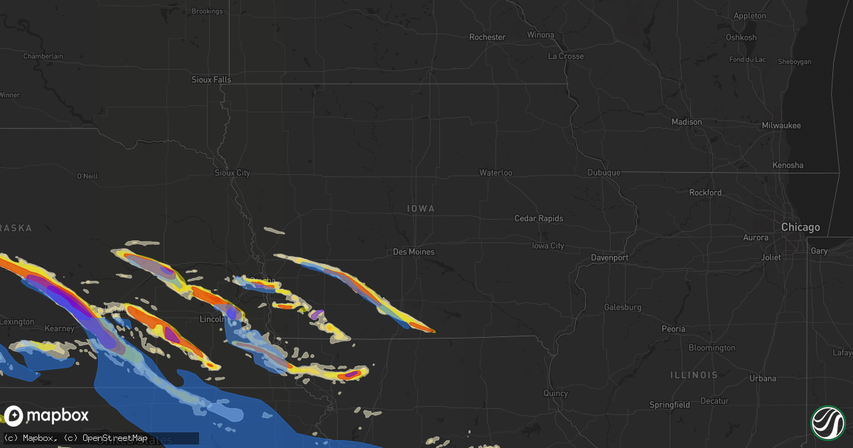
Hail Map in Iowa on June 7, 2022
Get this storm
June 7 map
$229
one time, instant access
Download today. No call, no setup
Keep the $229
Bought the map and want the full workflow? Apply the entire $229 to a subscription within 7 days. None of it is wasted.
Every map, not just this one
This buys you this map. Subscription and you get every map we run, in the markets you choose from a few cities to whole states to nationwide. Plus real-time alerts the moment a storm fires.
Contact data
Name, contact info, occupancy, even credit band for addresses in the footprint. You go from where it hit to who to call.
Become the source they trust
Unlimited branding weather history reports on demand. You already have the documented answer ready for the property owner, and you are the one who showed up with it.
Property data and RoofTrace estimates
Pull up any address you have got, its value and the exact code rules for that jurisdiction, straight from One Click Code. Then RoofTrace estimates the squares, pitch, and roof value, priced the way you price.
Storm reports in Iowa
Iowa
| Date | Description |
|---|---|
| 06/07/20226:45 PM CDT | A local report indicates 67 MPH wind near 1 W ATLANTIC |
| 06/07/20226:17 PM CDT | Delayed report. Semi blown over. Time estimated from radar. |
| 06/07/20224:57 AM CDT | At 957 PM CDT, a severe thunderstorm was located 5 miles southwest of Villisca, or 8 miles north of Clarinda, moving east at 35 mph. HAZARD...60 mph wind gusts and quarter size hail. SOURCE...Radar indicated. IMPACT...Hail damage to vehicles is expected. Expect wind damage to roofs, siding, and trees. This severe thunderstorm will remain over mainly rural areas of southeastern Montgomery and northeastern Page Counties, including the following locations... Hepburn and Viking Lake State Park. |
| 06/07/20224:53 AM CDT | At 953 PM CDT, a severe thunderstorm was located near Clarinda, or 19 miles northwest of Bedford, moving east at 25 mph. HAZARD...60 mph wind gusts and quarter size hail. SOURCE...Radar indicated. IMPACT...Hail damage to vehicles is expected. Expect wind damage to roofs, siding, and trees. Locations impacted include... New Market and Gravity. |
| 06/07/20224:52 AM CDT | At 952 PM CDT, a severe thunderstorm was located 3 miles southeast of Syracuse, or 14 miles west of Nebraska City, moving southeast at 35 mph. HAZARD...60 mph wind gusts and quarter size hail. SOURCE...Radar indicated. IMPACT...Hail damage to vehicles is expected. Expect wind damage to roofs, siding, and trees. This severe thunderstorm will be near... Talmage and Lorton around 1005 PM CDT.Other locations in the path of this severe thunderstorm includeBrock, Julian, Auburn and Peru.This includes Interstate 29 between mile markers 1 and 15. |
| 06/07/20224:34 AM CDT | At 934 PM CDT, a severe thunderstorm was located 7 miles northeast of Essex, or 8 miles south of Red Oak, moving east at 35 mph. HAZARD...60 mph wind gusts and quarter size hail. SOURCE...Radar indicated. IMPACT...Hail damage to vehicles is expected. Expect wind damage to roofs, siding, and trees. Locations impacted include... Villisca. |
| 06/07/20224:26 AM CDT | At 926 PM CDT, a severe thunderstorm was located 9 miles southwest of Corydon, moving southeast at 30 mph. HAZARD...60 mph wind gusts and quarter size hail. SOURCE...Radar indicated. IMPACT...Hail damage to vehicles is expected. Expect wind damage to roofs, siding, and trees. Locations impacted include... Lucerne and Powersville. |
| 06/07/20223:53 AM CDT | At 853 PM CDT, severe thunderstorms were located along a line extending from near Henderson to 3 miles southwest of Malvern, moving east at 35 mph. HAZARD...60 mph wind gusts and half dollar size hail. SOURCE...Radar indicated. IMPACT...Hail damage to vehicles is expected. Expect wind damage to roofs, siding, and trees. Severe thunderstorms will be near... Macedonia and Henderson around 900 PM CDT.Other locations in the path of these severe thunderstorms includeEmerson, Elliott, Red Oak, Grant, Stanton and Villisca. |
| 06/07/20223:28 AM CDT | At 828 PM CDT, a severe thunderstorm was located 7 miles east of Sun Valley Lake, or 13 miles southwest of Osceola, moving southeast at 45 mph. HAZARD...60 mph wind gusts and quarter size hail. SOURCE...Radar indicated. IMPACT...Hail damage to vehicles is expected. Expect wind damage to roofs, siding, and trees. This severe thunderstorm will be near... Van Wert, Decatur City and Weldon around 840 PM CDT. Leon around 845 PM CDT.Other locations in the path of this severe thunderstorm includeGarden Grove.This includes Interstate 35 between mile markers 4 and 32. |
| 06/07/20222:51 AM CDT | At 750 PM CDT, a severe thunderstorm was located near Green Valley Lake, or near Creston, moving southeast at 55 mph. HAZARD...60 mph wind gusts and quarter size hail. SOURCE...Radar indicated. IMPACT...Hail damage to vehicles is expected. Expect wind damage to roofs, siding, and trees. This severe thunderstorm will be near... Afton and Arispe around 800 PM CDT. Lorimor around 805 PM CDT. Murray and Thayer around 810 PM CDT.Other locations in the path of this severe thunderstorm include SunValley Lake, Murray Roadside Rest Area and Grand River.This includes Interstate 35 between mile markers 27 and 41. |
| 06/07/20222:12 AM CDT | At 712 PM CDT, a severe thunderstorm was located 12 miles southeast of Atlantic, moving southeast at 30 mph. HAZARD...60 mph wind gusts and quarter size hail. SOURCE...Radar indicated. IMPACT...Hail damage to vehicles is expected. Expect wind damage to roofs, siding, and trees. This severe thunderstorm will be near... Bridgewater around 725 PM CDT.Other locations in the path of this severe thunderstorm includeFontanelle, Nodaway Park and Orient. |
| 06/07/20221:55 AM CDT | At 655 PM CDT, a severe thunderstorm was located near Atlantic, moving southeast at 35 mph. HAZARD...60 mph wind gusts and quarter size hail. SOURCE...Radar indicated. IMPACT...Hail damage to vehicles is expected. Expect wind damage to roofs, siding, and trees. This severe thunderstorm will be near... Cumberland and Lake Anita State Park around 700 PM CDT. Massena around 710 PM CDT. |
| 06/06/202210:30 PM CDT | Broken wind shields... Holes in siding and windows... And destruction of nearby crops on 3 different properties. Hail lasted for 20 minutes and accumulated into drifts. |
| 06/06/202210:30 PM CDT | Social media report. At least half dollar sized hail broke vehicle windshields... House windows... Skylight windows... And damaged house siding. Multiple big holes. Tre |
| 06/06/20229:47 PM CDT | Large tree limbs down. Significant damage to crops due to wind driven hail. Unknown hail size. |
| 06/06/20229:46 PM CDT | 1 ft tree limb down. Time estimated from radar. |
| 06/06/20229:07 PM CDT | A local report indicates 1.00 inch wind near 4 S HASTINGS |
| 06/06/20228:53 PM CDT | Social media report and photo of wind blown large hail causing damage to siding... Windows... Gutters... Screens and air conditioner. Time estimated from radar. |
| 06/06/20228:27 PM CDT | Tin blown off of outbuilding on r15. Time estimated. |
| 06/06/20228:24 PM CDT | Mping report. |
| 06/06/20228:15 PM CDT | A local report indicates 1.00 inch wind near 1 NNE COUNCIL BLUFFS |
| 06/06/20228:00 PM CDT | Trees... Sheds... And power lines down. |
| 06/06/20228:00 PM CDT | Reported at 8 pm and 805 pm. |
| 06/06/20227:54 PM CDT | Farm outbuildings damaged on cherry street rd. Time estimated. |
| 06/06/20227:53 PM CDT | Report from mping: trees uprooted or snapped; roof blown off. |
| 06/06/20227:48 PM CDT | Nickel to quarter sized hail. |
| 06/06/20227:45 PM CDT | Large tree down on house. Time estimated. |
| 06/06/20227:37 PM CDT | Reported via twitter. |
| 06/06/20227:33 PM CDT | Roof blown off of machine shed. Time estimated. |
| 06/06/20227:30 PM CDT | Wind driven hail event that featured hail up to half dollar sized and winds well over 60 mph that lasted for 15 to 20 minutes. Just emerged corn and beans are pulverize |
| 06/06/20227:30 PM CDT | Pine trees uprooted and split. Damage to an outbuilding. Some windows broken on buildings. |
| 06/06/20227:29 PM CDT | A local report indicates 1.00 inch wind near FONTANELLE |
All States Impacted by Hail Map on June 7, 2022
Cities Impacted by Hail Map on June 7, 2022
- Harrison, NE
- Humphrey, NE
- Newman Grove, NE
- Albion, NE
- Lindsay, NE
- Saint Edward, NE
- Rapid City, SD
- Manville, WY
- Piedmont, SD
- Sutherland, NE
- Bayard, NE
- Harrisburg, NE
- Bridgeport, NE
- Broadwater, NE
- Gering, NE
- Mitchell, NE
- Lyman, NE
- Lusk, WY
- Rock Port, MO
- Sturgis, SD
- Vale, SD
- Eagle, NE
- Unadilla, NE
- Palmyra, NE
- Walton, NE
- Alvo, NE
- Greenwood, NE
- Lincoln, NE
- Shickley, NE
- Strang, NE
- Geneva, NE
- Sutton, NE
- Ohiowa, NE
- Grafton, NE
- Crawford, NE
- Torrington, WY
- Pisgah, IA
- Dunlap, IA
- Woodbine, IA
- Moorhead, IA
- Pine Ridge, SD
- Alliance, NE
- Hay Springs, NE
- Hill City, SD
- Belgrade, NE
- Genoa, NE
- Brainard, NE
- Rising City, NE
- Cedar Rapids, NE
- Weston, NE
- David City, NE
- Fullerton, NE
- Monroe, NE
- Dwight, NE
- Ulysses, NE
- Bellwood, NE
- Shelby, NE
- Bee, NE
- Surprise, NE
- Platte Center, NE
- Columbus, NE
- Davey, NE
- Primrose, NE
- Valparaiso, NE
- Seward, NE
- Osceola, NE
- Waverly, NE
- Duncan, NE
- Ceresco, NE
- Raymond, NE
- Silver Creek, NE
- Fairfax, MO
- York, NE
- Saronville, NE
- Mount Carmel, IL
- Owensville, IN
- Prague, NE
- Bruno, NE
- Ramah, CO
- Orleans, NE
- Culbertson, NE
- Trenton, NE
- Stratton, NE
- Barnett, MO
- Eldon, MO
- Rocky Mount, MO
- Gravois Mills, MO
- Sharon Springs, KS
- Sidney, NE
- Peetz, CO
- Lakeside, NE
- Hemingford, NE
- Marsland, NE
- Ellsworth, NE
- Eustis, NE
- Solano, NM
- Imogene, IA
- Red Oak, IA
- Essex, IA
- Columbia, MO
- Centralia, MO
- Harrisburg, MO
- Fayette, MO
- Clark, MO
- Hallsville, MO
- Armstrong, MO
- Sturgeon, MO
- Glasgow, MO
- Higbee, MO
- New Franklin, MO
- Franklin, MO
- Petersburg, TN
- Fayetteville, TN
- Manter, KS
- Colorado Springs, CO
- Carrollton, MO
- De Witt, MO
- Gypsum, KS
- Abilene, KS
- Hope, KS
- Salina, KS
- Solomon, KS
- Lebanon, TN
- Argyle, MO
- Saint Elizabeth, MO
- Camdenton, MO
- Brinktown, MO
- Kaiser, MO
- Lake Ozark, MO
- Osage Beach, MO
- Saint Thomas, MO
- Olean, MO
- Ulman, MO
- Brumley, MO
- Tuscumbia, MO
- Iberia, MO
- Eugene, MO
- Henley, MO
- Meta, MO
- Dixon, MO
- Sunrise Beach, MO
- Vienna, MO
- Usaf Academy, CO
- Slater, MO
- Blue Rapids, KS
- Salisbury, MO
- Strong City, KS
- Miami, MO
- Raymondville, MO
- Burlington, CO
- Plattsburg, MO
- Osborn, MO
- Stewartsville, MO
- Liberty, MO
- Kansas City, MO
- White Bluff, TN
- Ashland City, TN
- Charlotte, TN
- Odessa, MO
- Centerview, MO
- Bates City, MO
- Holden, MO
- Lone Jack, MO
- Oak Grove, MO
- Joiner, AR
- Bassett, AR
- Frenchmans Bayou, AR
- Gleason, TN
- Huntsville, AL
- Meridianville, AL
- Bloomington Springs, TN
- Gainesboro, TN
- Elmwood, NE
- Murdock, NE
- Kansas City, KS
- Danville, AL
- Hartselle, AL
- Stringtown, OK
- Trenton, TN
- Lithia, FL
- Wimauma, FL
- Silver Point, TN
- Smithville, TN
- Baxter, TN
- Aurora, NE
- Giltner, NE
- Phillips, NE
- Doniphan, NE
- Butler, MO
- Wagon Mound, NM
- Rattan, OK
- Ringold, OK
- Rufe, OK
- Fort Towson, OK
- Valliant, OK
- Boncarbo, CO
- Weston, CO
- Trinidad, CO
- Huntingdon, TN
- McKenzie, TN
- Dumas, TX
- Sunray, TX
- Lane, OK
- Moulton, AL
- Ohatchee, AL
- Gadsden, AL
- Fitzhugh, OK
- Ada, OK
- New Hope, AL
- Gurley, AL
- Woodville, AL
- Paint Rock, AL
- Graham, MO
- Rea, MO
- King City, MO
- Barnard, MO
- Darlington, MO
- Bolckow, MO
- Stanberry, MO
- Albany, MO
- Guilford, MO
- Panhandle, TX
- Amarillo, TX
- Akron, CO
- Otis, CO
- Anita, IA
- Wiota, IA
- Wray, CO
- Yuma, CO
- Eckley, CO
- Lindon, CO
- Woodrow, CO
- Atwood, KS
- West Blocton, AL
- Brent, AL
- Centreville, AL
- Mulberry, TN
- Lynchburg, TN
- Winchester, TN
- Canadian, TX
- Walsh, CO
- Mullen, NE
- Merriman, NE
- Bingham, NE
- Whitman, NE
- Valentine, NE
- Seneca, NE
- Ashby, NE
- Tupelo, OK
- Arapahoe, NE
- Holbrook, NE
- Cambridge, NE
- Holyoke, CO
- Lodgepole, NE
- Ovid, CO
- Norton, KS
- Herndon, KS
- Hayes Center, NE
- Norcatur, KS
- Jennings, KS
- Venango, NE
- Julesburg, CO
- Potter, NE
- Dix, NE
- Parks, NE
- Grant, NE
- Imperial, NE
- McCook, NE
- Clayton, KS
- Palisade, NE
- Wauneta, NE
- Max, NE
- Amherst, CO
- Lenora, KS
- Enders, NE
- Dresden, KS
- Champion, NE
- Sedgwick, CO
- Benkelman, NE
- Chappell, NE
- Oberlin, KS
- Grant, AL
- Ludell, KS
- McDonald, KS
- Hildreth, NE
- Minden, NE
- Elwood, NE
- Bertrand, NE
- Smithfield, NE
- Holdrege, NE
- Funk, NE
- Axtell, NE
- Loomis, NE
- Sullivan, MO
- Owens Cross Roads, AL
- New Hampton, MO
- Rolla, KS
- Campbell, NE
- Dannebrog, NE
- Boelus, NE
- Farwell, NE
- Stanton, IA
- New Market, IA
- Clarinda, IA
- Blockton, IA
- Hopkins, MO
- Villisca, IA
- Bedford, IA
- Shenandoah, IA
- Sheridan, MO
- Franklin, TN
- Dickson, TN
- Robbins, TN
- Sunbright, TN
- Saint James, MO
- Bon Aqua, TN
- Cottondale, AL
- Detroit, TX
- Wesley Chapel, FL
- Tampa, FL
- Syracuse, NE
- Dresden, TN
- Hooker, OK
- Stearns, KY
- Mount Juliet, TN
- Tecumseh, NE
- Wymore, NE
- Liberty, NE
- Westmoreland, KS
- Peyton, CO
- Calhan, CO
- Granada, CO
- Warrensburg, MO
- Paron, AR
- Kit Carson, CO
- Coalgate, OK
- Watertown, TN
- Fittstown, OK
- Roff, OK
- Stratford, OK
- Beverly, KS
- Lincoln, KS
- Tescott, KS
- Anton, CO
- Guymon, OK
- Edgar, NE
- Ong, NE
- Davenport, NE
- Oak, NE
- Butler, OK
- Hammon, OK
- Atoka, OK
- Ansley, NE
- Ordway, CO
- Wallace, KS
- Ashton, NE
- Clarksville, AR
- Goodland, KS
- Fredericktown, MO
- Sainte Genevieve, MO
- Saint Mary, MO
- Perryville, MO
- Holladay, TN
- Celina, TN
- Burkesville, KY
- Tompkinsville, KY
- Doe Run, MO
- Farmington, MO
- Nashville, TN
- Fairview, TN
- Kingston Springs, TN
- Burns, TN
- Pegram, TN
- Hohenwald, TN
- Waynesboro, TN
- Model, CO
- Scottsboro, AL
- Section, AL
- Dutton, AL
- Warsaw, MO
- Edwards, MO
- McEwen, TN
- Blanchard, OK
- Trezevant, TN
- Atwood, TN
- Madison, AL
- Wapanucka, OK
- Antlers, OK
- Wardville, OK
- Moyers, OK
- Concord, AR
- Piedmont, AL
- Boaz, AL
- Neola, IA
- Persia, IA
- Judsonia, AR
- Humeston, IA
- Leon, IA
- Van Wert, IA
- Weldon, IA
- Massena, IA
- Allerton, IA
- Garden Grove, IA
- Bridgewater, IA
- Walnut, IA
- Creston, IA
- Grand River, IA
- Atlantic, IA
- Cumberland, IA
- Ellston, IA
- Shannon City, IA
- Shelby, IA
- Marne, IA
- Greenfield, IA
- Corydon, IA
- Afton, IA
- Murray, IA
- Fontanelle, IA
- Orient, IA
- Avoca, IA
- Thayer, IA
- Osceola, IA
- Cope, CO
- Salem, MO
- Trimble, TN
- Newbern, TN
- Durham, OK
- Foss, OK
- Elk City, OK
- Crawford, OK
- Cheyenne, OK
- Clinton, OK
- Reydon, OK
- Arapaho, OK
- Weatherford, OK
- Rainbow City, AL
- Callaway, NE
- Merna, NE
- Broken Bow, NE
- Lamar, CO
- Hugo, CO
- Sugar City, CO
- Rush, CO
- Karval, CO
- Deadwood, SD
- Nemo, SD
- Wahoo, NE
- Haxtun, CO
- Saint Paul, NE
- Elba, NE
- Logan, IA
- Minden, IA
- Clio, IA
- Tingley, IA
- Lineville, IA
- Watson, MO
- Tarkio, MO
- Byers, CO
- Brunswick, MO
- Pleasant Shade, TN
- Carthage, TN
- Burr, NE
- Talmage, NE
- Nebraska City, NE
- Mound City, MO
- Cook, NE
- Julian, NE
- Dunbar, NE
- Nemaha, NE
- Verdon, NE
- Craig, MO
- Douglas, NE
- Oregon, MO
- Brock, NE
- Maryville, MO
- Peru, NE
- Skidmore, MO
- Maitland, MO
- Shubert, NE
- Humboldt, NE
- Sterling, NE
- Lorton, NE
- Falls City, NE
- Rulo, NE
- Stella, NE
- Brownville, NE
- Otoe, NE
- Auburn, NE
- Rosendale, MO
- Johnson, NE
- Berryton, KS
- Topeka, KS
- Kim, CO
- Mustang, OK
- Oklahoma City, OK
- Wheatland, OK
- Miami, NM
- Lavinia, TN
- Milan, TN
- Richfield, KS
- Johnson, KS
- Hugoton, KS
- Mountain Grove, MO
- Vega, TX
- Licking, MO
- Stonewall, OK
- Maysville, OK
- Pauls Valley, OK
- Wynnewood, OK
- Amber, OK
- Lexington, OK
- Centrahoma, OK
- Allen, OK
- Chickasha, OK
- Lindsay, OK
- Paoli, OK
- Washington, OK
- Wanette, OK
- Wayne, OK
- Byars, OK
- Purcell, OK
- Alex, OK
- Bard, NM
- Trementina, NM
- San Jon, NM
- Adrian, TX
- Tucumcari, NM
- Logan, NM
- Conchas Dam, NM
- Mosquero, NM
- Jay Em, WY
- Hubbell, NE
- Morrowville, KS
- Fairfield, NE
- Narka, KS
- Deshler, NE
- Deweese, NE
- Haddam, KS
- Clay Center, NE
- Hanover, KS
- Harvard, NE
- Chester, NE
- Fairbury, NE
- Hebron, NE
- Reynolds, NE
- Mahaska, KS
- Washington, KS
- Hordville, NE
- Curtis, NE
- Moorefield, NE
- Stockville, NE
- Farnam, NE
- Glenrock, WY
- Savannah, MO
- Bourbon, MO
- Glenwood, IA
- Malvern, IA
- Pacific Junction, IA
- Hastings, IA
- Emerson, IA
- Durham, KS
- Tampa, KS
- Bradshaw, NE
- Benedict, NE
- Polk, NE
- Bellevue, NE
- Council Bluffs, IA
- Mineola, IA
- Waterloo, NE
- Yutan, NE
- Elkhorn, NE
- Silver City, IA
- Boys Town, NE
- Omaha, NE
- Henderson, IA
- La Vista, NE
- Kingsville, MO
- College Grove, TN
- Eagleville, TN
- Arrington, TN
- Rockvale, TN
- Eldridge, MO
- Lebanon, MO
- Channing, TX
- Bethune, CO
- Edson, KS
- Flagler, CO
- Seibert, CO
- Kanorado, KS
- Weskan, KS
- Deer Trail, CO
- Vona, CO
- Fort Morgan, CO
- Stratton, CO
- Holly, CO
- Natoma, KS
- Waldo, KS
- Paradise, KS
- Yuma, TN
- Attalla, AL
- Union Grove, AL
- Bismarck, MO
- Ironton, MO
- Rocky Ford, CO
- Beulah, CO
- Pueblo, CO
- Rye, CO
- Fowler, CO
- Litchfield, NE
- Mason City, NE
- Hazard, NE
- Pleasanton, NE
- Firth, NE
- Adams, NE
- Plattsmouth, NE
- Murray, NE
- Bladen, NE
- Roseland, NE
- Holstein, NE
- Easton, KS
- Versailles, MO
- Stratford, TX
- Texhoma, OK
- Goodwell, OK
- Gruver, TX
- Texhoma, TX
- Jamestown, TN
- Hollow Rock, TN
- Cactus, TX
- Brownsville, TN
- Summertown, TN
- Avondale, CO
- Trinchera, CO
- Laceys Spring, AL
- Cullman, AL
- Eva, AL
- Somerville, AL
- Jacksonville, AL
- Treynor, IA
- Valley, NE
- Papillion, NE
- Beaver City, NE
- Hendley, NE
- Madison, TN
- Goodlettsville, TN
- Joes, CO
- Paris, TN
- Palmersville, TN
- Campo, CO
- Cedar Grove, TN
- Roy, NM
- Beatrice, NE
- Fairmont, NE
- Henderson, NE
- De Witt, NE
- Grand Island, NE
- Exeter, NE
- Dorchester, NE
- Swanton, NE
- McCool Junction, NE
- Friend, NE
- Western, NE
- Marquette, NE
- Hampton, NE
- Wilber, NE
- Milligan, NE
- Lamar, AR
- London, AR
- Knoxville, AR
- Conception Junction, MO
- Conception, MO
- Mead, NE
- Yoder, CO
- California, MO
- Belleview, MO
- Middle Brook, MO
- Central City, NE
- Clarks, NE
- Palmer, NE
- Wellington, AL
- Home, KS
- Frankfort, KS
- Beattie, KS
- Marysville, KS
- Crook, CO
- Kidder, MO
- Cameron, MO
- Lees Summit, MO
- Independence, MO
- Blue Springs, MO
- Monterey, TN
- Cookeville, TN
- Cadet, MO
- Beech Grove, AR
- Lyles, TN
- Okeechobee, FL
- Ayr, NE
- Trumbull, NE
- Wood River, NE
- Ravenna, NE
- Cairo, NE
- Blue Hill, NE
- Alda, NE
- Stapleton, NE
- Anselmo, NE
- Arnold, NE
- Glenvil, NE
- Thedford, NE
- Kenesaw, NE
- Westerville, NE
- Gibbon, NE
- Loup City, NE
- Hastings, NE
- Inland, NE
- Arcadia, NE
- Oconto, NE
- Rockville, NE
- Juniata, NE
- Shelton, NE
- Elkhart, KS
- Chapman, NE
- Barnes, KS
- Waterville, KS
- Carleton, NE
- Plymouth, NE
- Tobias, NE
- Ruskin, NE
- Cordova, NE
- Lawrence, NE
- Greenleaf, KS
- Hollenberg, KS
- Nelson, NE
- Munden, KS
- Bremen, KS
- Heartwell, NE
- Avoca, NE
- Weeping Water, NE
- Henry, TN
- Hazel Green, AL
- Herington, KS
- Potosi, MO
- Goff, KS
- Wetmore, KS
- Netawaka, KS
- Vanleer, TN
- Cumberland Furnace, TN
- Fort Leavenworth, KS
- Leavenworth, KS
- Burlington Junction, MO
- New Cambria, KS
- Pangburn, AR
- Edison, NE
- Blackwell, MO
- Richwoods, MO
- Elmwood, TN
- Lancaster, TN
- Buffalo Valley, TN
- Arab, AL
- Guntersville, AL
- Fruithurst, AL
- Magazine, AR
- New Market, AL
- Erin, TN
- Mills, NM
- Chestnut Mound, TN
- Granville, TN
- Scranton, AR
- Delaware, AR
- New Blaine, AR
- Bland, MO
- Vichy, MO
- Belle, MO
- Miami, TX
- Osceola, AR
- Linwood, NE
- Leslie, MO
- Gerald, MO
- Rosebud, MO
- Boonville, IN
- Lynnville, IN
- Tennyson, IN
- Valhermoso Springs, AL
- Paragould, AR
- Bono, AR
- Bennet, NE
- Roca, NE
- Atlanta, NE
- Wilcox, NE
- Atchison, KS
- Syracuse, KS
- Rolla, MO
- Williamsburg, KY
- Mount Pleasant, TN
- Culleoka, TN
- Lynnville, TN
- Danbury, NE
- Haigler, NE
- Grain Valley, MO
- Logan, KS
- Owensville, MO
- Limon, CO
- Haswell, CO
- Eads, CO
- Hasty, CO
- Elbert, CO
- Perryton, TX
- Hardesty, OK
- Spearman, TX
- McClave, CO
- Arlington, CO
- Las Animas, CO
- La Junta, CO
- Wiley, CO
- Corn, OK
- Matheson, CO
- Briscoe, TX
- Balko, OK
- Sayre, OK
- Keyes, OK
- Centre, AL
- Bagwell, TX
- Randolph, AL
- Manning, IA
- Audubon, IA
- Kyle, SD
- New Bloomfield, MO
- Hartsburg, MO
- Ashland, MO
- Prescott, IA
- Calera, AL
- Hancock, IA
- Lenexa, KS
- Leawood, KS
- Overland Park, KS
- Dalton, NE
- Melbeta, NE
- Hyannis, NE
- Gurley, NE
- Oshkosh, NE
- Crete, NE
- Sawyer, OK
- Finley, OK
- Hugo, OK
- Sulphur, OK
- Soper, OK
- Milburn, OK
- Davis, OK
- Tishomingo, OK
- Spencerville, OK
- Mill Creek, OK
- Stuart, OK
- Calvin, OK
- Brownsboro, AL
- Uniontown, AR
- Natural Dam, AR
- Cedarville, AR
- Van Buren, AR
- Rudy, AR
- Stinnett, TX
- Morse, TX
- White Deer, TX
- Fritch, TX
- Canyon, TX
- Borger, TX
- Skellytown, TX
- Claude, TX
- Masterson, TX
- Pampa, TX
- Groom, TX
- Van Tassell, WY
- Lewellen, NE
- Oketo, KS
- Meriden, KS
- Scandia, KS
- Muscotah, KS
- Powhattan, KS
- Excelsior Springs, MO
- Weston, MO
- Whiting, KS
- Grandview, MO
- Formoso, KS
- Diller, NE
- Sedalia, MO
- Rossville, KS
- Circleville, KS
- Mankato, KS
- Nortonville, KS
- Superior, NE
- Corder, MO
- Bonner Springs, KS
- Higginsville, MO
- Olsburg, KS
- Eudora, KS
- Syracuse, MO
- Jewell, KS
- Wamego, KS
- Guide Rock, NE
- Leonardville, KS
- Norway, KS
- Green Ridge, MO
- Farley, MO
- Belvue, KS
- Odell, NE
- Linwood, KS
- Tecumseh, KS
- Pilot Grove, MO
- Concordia, KS
- Morganville, KS
- Saint Marys, KS
- Lexington, MO
- Bunceton, MO
- Otterville, MO
- Missouri City, MO
- Olathe, KS
- Clifton, KS
- Oneida, KS
- Webber, KS
- Summerfield, KS
- Horton, KS
- Tipton, MO
- Ozawkie, KS
- Manhattan, KS
- Green, KS
- Mission, KS
- Concordia, MO
- Centralia, KS
- Chapman, KS
- Junction City, KS
- Seneca, KS
- Palmer, KS
- Hughesville, MO
- Randolph, KS
- Basehor, KS
- Baileyville, KS
- Riley, KS
- Camden, MO
- Onaga, KS
- Wakefield, KS
- Esbon, KS
- Buckner, MO
- Effingham, KS
- Clay Center, KS
- Milford, KS
- Houstonia, MO
- Axtell, KS
- Sabetha, KS
- Valley Falls, KS
- Boonville, MO
- Fairview, KS
- Lecompton, KS
- Marshall, MO
- Tonganoxie, KS
- Alma, KS
- Longford, KS
- Jansen, NE
- Clyde, KS
- Silver Lake, KS
- Holton, KS
- Clarksburg, MO
- Lawrence, KS
- Waldron, MO
- Levasy, MO
- Pleasant Hill, MO
- Aurora, KS
- Havensville, KS
- Prairie Village, KS
- Nelson, MO
- Napoleon, MO
- Oskaloosa, KS
- Byron, NE
- Sweet Springs, MO
- Cuba, KS
- Courtland, KS
- Agenda, KS
- Ogden, KS
- Paxico, KS
- Sibley, MO
- Winchester, KS
- Greenwood, MO
- Miltonvale, KS
- Jamestown, KS
- Cummings, KS
- Mayetta, KS
- Fort Riley, KS
- Perry, KS
- Denison, KS
- Smithton, MO
- Republic, KS
- Endicott, NE
- Steele City, NE
- Corning, KS
- Henrietta, MO
- Mayview, MO
- Blackwater, MO
- Orrick, MO
- Linn, KS
- Emmett, KS
- Lebanon, KS
- Soldier, KS
- Burr Oak, KS
- Belvidere, NE
- Saint George, KS
- Vermillion, KS
- Blackburn, MO
- Lansing, KS
- Maple Hill, KS
- Platte City, MO
- Shawnee, KS
- Hoyt, KS
- Kearney, MO
- Knob Noster, MO
- Randall, KS
- Delia, KS
- La Monte, MO
- McLouth, KS
- Wellington, MO
- Riverside, MO
- Red Cloud, NE
- Florence, MO
- De Soto, KS
- Smithville, MO
- Richmond, MO
- Hardy, NE
- Grantville, KS
- Whiteman Air Force Base, MO
- Belleville, KS
- Selden, KS
- Gretna, NE
- Offutt Afb, NE
- Bloomington, NE
- Naponee, NE
- Alma, NE
- Oxford, NE
- Upland, NE
- Republican City, NE
- Franklin, NE
- Stamford, NE
- Elk Creek, NE
- Panama, NE
- Winona, KS
- Simla, CO
- Decatur, IA


