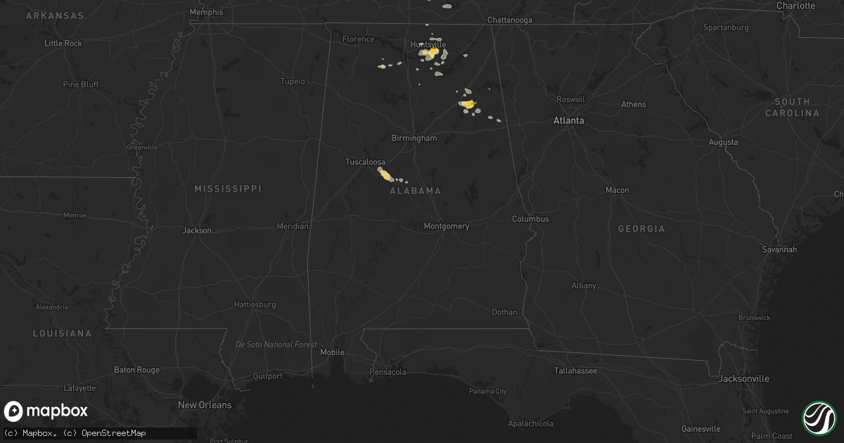
Hail Map in Alabama on June 7, 2022
Get this storm
June 7 map
$229
one time, instant access
Download today. No call, no setup
Keep the $229
Bought the map and want the full workflow? Apply the entire $229 to a subscription within 7 days. None of it is wasted.
Every map, not just this one
This buys you this map. Subscription and you get every map we run, in the markets you choose from a few cities to whole states to nationwide. Plus real-time alerts the moment a storm fires.
Contact data
Name, contact info, occupancy, even credit band for addresses in the footprint. You go from where it hit to who to call.
Become the source they trust
Unlimited branding weather history reports on demand. You already have the documented answer ready for the property owner, and you are the one who showed up with it.
Property data and RoofTrace estimates
Pull up any address you have got, its value and the exact code rules for that jurisdiction, straight from One Click Code. Then RoofTrace estimates the squares, pitch, and roof value, priced the way you price.
Storm reports in Alabama
Alabama
| Date | Description |
|---|---|
| 06/07/20226:25 PM CDT | One large tree down blocking the roadway on lonesome bend road. A few other trees down in the area and one was on a vehicle. |
| 06/07/20225:24 PM CDT | A local report indicates 1.00 inch wind near 1 S GLENCOE |
| 06/07/20225:11 PM CDT | A local report indicates 1.00 inch wind near GLENCOE |
| 06/07/20225:09 PM CDT | Several power lines down due to strong thunderstorm winds on green mountain in south huntsville. |
| 06/07/20225:07 PM CDT | Powerlines down on hwy 431 near hayes nature preserve. |
| 06/07/20225:06 PM CDT | Quarter size hail measured at tailgaters restaurant in hampton cove. |
| 06/07/20225:05 PM CDT | Several trees down across green mountain along shawdee road. A home in the inspiration subdivision had severe damage due to fallen trees. |
| 06/07/20225:05 PM CDT | Ping pong ball hail in the hampton cove area of se huntsville. |
| 06/07/20225:02 PM CDT | Half dollar hail in owens crossroads. |
| 06/07/20224:56 PM CDT | A local report indicates 1.50 inch wind near 2 ENE GLENCOE |
| 06/07/20226:17 AM CDT | Mt brook pd reports trees down on stone river rd close to old leads rd. |
| 06/07/20224:30 AM CDT | Tree down on mt. Olive road. Via social media. |
| 06/07/20224:10 AM CDT | Trees reported down throughout the city of homewood. Some large. Via social media. |
| 06/07/202212:55 AM CDT | At 554 PM CDT, a severe thunderstorm was located over Attalla, moving west at 10 mph. HAZARD...Quarter size hail. SOURCE...Radar indicated. IMPACT...Damage to vehicles is expected. Locations impacted include... Gadsden, Rainbow City, Attalla, Glencoe, Reece City, Gadsden Mall, Neely Henry Lake, Southside, Big Wills Creek, Gadsden Municipal Airport and Ramsey. |
| 06/07/202212:03 AM CDT | At 503 PM CDT, a severe thunderstorm was located over Hokes Bluff, moving east at 10 mph. HAZARD...60 mph wind gusts and quarter size hail. SOURCE...Radar indicated. IMPACT...Hail damage to vehicles is expected. Expect wind damage to roofs, siding, and trees. Locations impacted include... Gadsden, Hokes Bluff, Glencoe, Ball Flat, Cobb City, Knightens Crossroads and Reaves. |
| 06/06/202211:59 PM CDT | At 458 PM CDT, a severe thunderstorm was located over Gurley, or 11 miles southeast of Huntsville, moving east at 30 mph. HAZARD...60 mph wind gusts and quarter size hail. SOURCE...Radar indicated. IMPACT...Hail damage to vehicles is expected. Expect wind damage to roofs, siding, and trees. Locations impacted include... Southern Huntsville, Scottsboro, Owens Cross Roads, Hollywood, Skyline, Gurley, Section, Woodville, Pleasant Groves and Langston. |
| 06/06/202210:02 PM CDT | At 302 PM CDT, a severe thunderstorm was located near Winchester, moving southeast at 20 mph. HAZARD...60 mph wind gusts. SOURCE...Radar indicated. IMPACT...Expect damage to roofs, siding, and trees. Locations impacted include... Winchester, Decherd, Cowan, Huntland, Tims Ford Lake, Lexie Crossroads, Beans Creek, Harmony, Maxwell and Belvidere. |
All States Impacted by Hail Map on June 7, 2022
Cities Impacted by Hail Map on June 7, 2022
- Harrison, NE
- Humphrey, NE
- Newman Grove, NE
- Albion, NE
- Lindsay, NE
- Saint Edward, NE
- Rapid City, SD
- Manville, WY
- Piedmont, SD
- Sutherland, NE
- Bayard, NE
- Harrisburg, NE
- Bridgeport, NE
- Broadwater, NE
- Gering, NE
- Mitchell, NE
- Lyman, NE
- Lusk, WY
- Rock Port, MO
- Sturgis, SD
- Vale, SD
- Eagle, NE
- Unadilla, NE
- Palmyra, NE
- Walton, NE
- Alvo, NE
- Greenwood, NE
- Lincoln, NE
- Shickley, NE
- Strang, NE
- Geneva, NE
- Sutton, NE
- Ohiowa, NE
- Grafton, NE
- Crawford, NE
- Torrington, WY
- Pisgah, IA
- Dunlap, IA
- Woodbine, IA
- Moorhead, IA
- Pine Ridge, SD
- Alliance, NE
- Hay Springs, NE
- Hill City, SD
- Belgrade, NE
- Genoa, NE
- Brainard, NE
- Rising City, NE
- Cedar Rapids, NE
- Weston, NE
- David City, NE
- Fullerton, NE
- Monroe, NE
- Dwight, NE
- Ulysses, NE
- Bellwood, NE
- Shelby, NE
- Bee, NE
- Surprise, NE
- Platte Center, NE
- Columbus, NE
- Davey, NE
- Primrose, NE
- Valparaiso, NE
- Seward, NE
- Osceola, NE
- Waverly, NE
- Duncan, NE
- Ceresco, NE
- Raymond, NE
- Silver Creek, NE
- Fairfax, MO
- York, NE
- Saronville, NE
- Mount Carmel, IL
- Owensville, IN
- Prague, NE
- Bruno, NE
- Ramah, CO
- Orleans, NE
- Culbertson, NE
- Trenton, NE
- Stratton, NE
- Barnett, MO
- Eldon, MO
- Rocky Mount, MO
- Gravois Mills, MO
- Sharon Springs, KS
- Sidney, NE
- Peetz, CO
- Lakeside, NE
- Hemingford, NE
- Marsland, NE
- Ellsworth, NE
- Eustis, NE
- Solano, NM
- Imogene, IA
- Red Oak, IA
- Essex, IA
- Columbia, MO
- Centralia, MO
- Harrisburg, MO
- Fayette, MO
- Clark, MO
- Hallsville, MO
- Armstrong, MO
- Sturgeon, MO
- Glasgow, MO
- Higbee, MO
- New Franklin, MO
- Franklin, MO
- Petersburg, TN
- Fayetteville, TN
- Manter, KS
- Colorado Springs, CO
- Carrollton, MO
- De Witt, MO
- Gypsum, KS
- Abilene, KS
- Hope, KS
- Salina, KS
- Solomon, KS
- Lebanon, TN
- Argyle, MO
- Saint Elizabeth, MO
- Camdenton, MO
- Brinktown, MO
- Kaiser, MO
- Lake Ozark, MO
- Osage Beach, MO
- Saint Thomas, MO
- Olean, MO
- Ulman, MO
- Brumley, MO
- Tuscumbia, MO
- Iberia, MO
- Eugene, MO
- Henley, MO
- Meta, MO
- Dixon, MO
- Sunrise Beach, MO
- Vienna, MO
- Usaf Academy, CO
- Slater, MO
- Blue Rapids, KS
- Salisbury, MO
- Strong City, KS
- Miami, MO
- Raymondville, MO
- Burlington, CO
- Plattsburg, MO
- Osborn, MO
- Stewartsville, MO
- Liberty, MO
- Kansas City, MO
- White Bluff, TN
- Ashland City, TN
- Charlotte, TN
- Odessa, MO
- Centerview, MO
- Bates City, MO
- Holden, MO
- Lone Jack, MO
- Oak Grove, MO
- Joiner, AR
- Bassett, AR
- Frenchmans Bayou, AR
- Gleason, TN
- Huntsville, AL
- Meridianville, AL
- Bloomington Springs, TN
- Gainesboro, TN
- Elmwood, NE
- Murdock, NE
- Kansas City, KS
- Danville, AL
- Hartselle, AL
- Stringtown, OK
- Trenton, TN
- Lithia, FL
- Wimauma, FL
- Silver Point, TN
- Smithville, TN
- Baxter, TN
- Aurora, NE
- Giltner, NE
- Phillips, NE
- Doniphan, NE
- Butler, MO
- Wagon Mound, NM
- Rattan, OK
- Ringold, OK
- Rufe, OK
- Fort Towson, OK
- Valliant, OK
- Boncarbo, CO
- Weston, CO
- Trinidad, CO
- Huntingdon, TN
- McKenzie, TN
- Dumas, TX
- Sunray, TX
- Lane, OK
- Moulton, AL
- Ohatchee, AL
- Gadsden, AL
- Fitzhugh, OK
- Ada, OK
- New Hope, AL
- Gurley, AL
- Woodville, AL
- Paint Rock, AL
- Graham, MO
- Rea, MO
- King City, MO
- Barnard, MO
- Darlington, MO
- Bolckow, MO
- Stanberry, MO
- Albany, MO
- Guilford, MO
- Panhandle, TX
- Amarillo, TX
- Akron, CO
- Otis, CO
- Anita, IA
- Wiota, IA
- Wray, CO
- Yuma, CO
- Eckley, CO
- Lindon, CO
- Woodrow, CO
- Atwood, KS
- West Blocton, AL
- Brent, AL
- Centreville, AL
- Mulberry, TN
- Lynchburg, TN
- Winchester, TN
- Canadian, TX
- Walsh, CO
- Mullen, NE
- Merriman, NE
- Bingham, NE
- Whitman, NE
- Valentine, NE
- Seneca, NE
- Ashby, NE
- Tupelo, OK
- Arapahoe, NE
- Holbrook, NE
- Cambridge, NE
- Holyoke, CO
- Lodgepole, NE
- Ovid, CO
- Norton, KS
- Herndon, KS
- Hayes Center, NE
- Norcatur, KS
- Jennings, KS
- Venango, NE
- Julesburg, CO
- Potter, NE
- Dix, NE
- Parks, NE
- Grant, NE
- Imperial, NE
- McCook, NE
- Clayton, KS
- Palisade, NE
- Wauneta, NE
- Max, NE
- Amherst, CO
- Lenora, KS
- Enders, NE
- Dresden, KS
- Champion, NE
- Sedgwick, CO
- Benkelman, NE
- Chappell, NE
- Oberlin, KS
- Grant, AL
- Ludell, KS
- McDonald, KS
- Hildreth, NE
- Minden, NE
- Elwood, NE
- Bertrand, NE
- Smithfield, NE
- Holdrege, NE
- Funk, NE
- Axtell, NE
- Loomis, NE
- Sullivan, MO
- Owens Cross Roads, AL
- New Hampton, MO
- Rolla, KS
- Campbell, NE
- Dannebrog, NE
- Boelus, NE
- Farwell, NE
- Stanton, IA
- New Market, IA
- Clarinda, IA
- Blockton, IA
- Hopkins, MO
- Villisca, IA
- Bedford, IA
- Shenandoah, IA
- Sheridan, MO
- Franklin, TN
- Dickson, TN
- Robbins, TN
- Sunbright, TN
- Saint James, MO
- Bon Aqua, TN
- Cottondale, AL
- Detroit, TX
- Wesley Chapel, FL
- Tampa, FL
- Syracuse, NE
- Dresden, TN
- Hooker, OK
- Stearns, KY
- Mount Juliet, TN
- Tecumseh, NE
- Wymore, NE
- Liberty, NE
- Westmoreland, KS
- Peyton, CO
- Calhan, CO
- Granada, CO
- Warrensburg, MO
- Paron, AR
- Kit Carson, CO
- Coalgate, OK
- Watertown, TN
- Fittstown, OK
- Roff, OK
- Stratford, OK
- Beverly, KS
- Lincoln, KS
- Tescott, KS
- Anton, CO
- Guymon, OK
- Edgar, NE
- Ong, NE
- Davenport, NE
- Oak, NE
- Butler, OK
- Hammon, OK
- Atoka, OK
- Ansley, NE
- Ordway, CO
- Wallace, KS
- Ashton, NE
- Clarksville, AR
- Goodland, KS
- Fredericktown, MO
- Sainte Genevieve, MO
- Saint Mary, MO
- Perryville, MO
- Holladay, TN
- Celina, TN
- Burkesville, KY
- Tompkinsville, KY
- Doe Run, MO
- Farmington, MO
- Nashville, TN
- Fairview, TN
- Kingston Springs, TN
- Burns, TN
- Pegram, TN
- Hohenwald, TN
- Waynesboro, TN
- Model, CO
- Scottsboro, AL
- Section, AL
- Dutton, AL
- Warsaw, MO
- Edwards, MO
- McEwen, TN
- Blanchard, OK
- Trezevant, TN
- Atwood, TN
- Madison, AL
- Wapanucka, OK
- Antlers, OK
- Wardville, OK
- Moyers, OK
- Concord, AR
- Piedmont, AL
- Boaz, AL
- Neola, IA
- Persia, IA
- Judsonia, AR
- Humeston, IA
- Leon, IA
- Van Wert, IA
- Weldon, IA
- Massena, IA
- Allerton, IA
- Garden Grove, IA
- Bridgewater, IA
- Walnut, IA
- Creston, IA
- Grand River, IA
- Atlantic, IA
- Cumberland, IA
- Ellston, IA
- Shannon City, IA
- Shelby, IA
- Marne, IA
- Greenfield, IA
- Corydon, IA
- Afton, IA
- Murray, IA
- Fontanelle, IA
- Orient, IA
- Avoca, IA
- Thayer, IA
- Osceola, IA
- Cope, CO
- Salem, MO
- Trimble, TN
- Newbern, TN
- Durham, OK
- Foss, OK
- Elk City, OK
- Crawford, OK
- Cheyenne, OK
- Clinton, OK
- Reydon, OK
- Arapaho, OK
- Weatherford, OK
- Rainbow City, AL
- Callaway, NE
- Merna, NE
- Broken Bow, NE
- Lamar, CO
- Hugo, CO
- Sugar City, CO
- Rush, CO
- Karval, CO
- Deadwood, SD
- Nemo, SD
- Wahoo, NE
- Haxtun, CO
- Saint Paul, NE
- Elba, NE
- Logan, IA
- Minden, IA
- Clio, IA
- Tingley, IA
- Lineville, IA
- Watson, MO
- Tarkio, MO
- Byers, CO
- Brunswick, MO
- Pleasant Shade, TN
- Carthage, TN
- Burr, NE
- Talmage, NE
- Nebraska City, NE
- Mound City, MO
- Cook, NE
- Julian, NE
- Dunbar, NE
- Nemaha, NE
- Verdon, NE
- Craig, MO
- Douglas, NE
- Oregon, MO
- Brock, NE
- Maryville, MO
- Peru, NE
- Skidmore, MO
- Maitland, MO
- Shubert, NE
- Humboldt, NE
- Sterling, NE
- Lorton, NE
- Falls City, NE
- Rulo, NE
- Stella, NE
- Brownville, NE
- Otoe, NE
- Auburn, NE
- Rosendale, MO
- Johnson, NE
- Berryton, KS
- Topeka, KS
- Kim, CO
- Mustang, OK
- Oklahoma City, OK
- Wheatland, OK
- Miami, NM
- Lavinia, TN
- Milan, TN
- Richfield, KS
- Johnson, KS
- Hugoton, KS
- Mountain Grove, MO
- Vega, TX
- Licking, MO
- Stonewall, OK
- Maysville, OK
- Pauls Valley, OK
- Wynnewood, OK
- Amber, OK
- Lexington, OK
- Centrahoma, OK
- Allen, OK
- Chickasha, OK
- Lindsay, OK
- Paoli, OK
- Washington, OK
- Wanette, OK
- Wayne, OK
- Byars, OK
- Purcell, OK
- Alex, OK
- Bard, NM
- Trementina, NM
- San Jon, NM
- Adrian, TX
- Tucumcari, NM
- Logan, NM
- Conchas Dam, NM
- Mosquero, NM
- Jay Em, WY
- Hubbell, NE
- Morrowville, KS
- Fairfield, NE
- Narka, KS
- Deshler, NE
- Deweese, NE
- Haddam, KS
- Clay Center, NE
- Hanover, KS
- Harvard, NE
- Chester, NE
- Fairbury, NE
- Hebron, NE
- Reynolds, NE
- Mahaska, KS
- Washington, KS
- Hordville, NE
- Curtis, NE
- Moorefield, NE
- Stockville, NE
- Farnam, NE
- Glenrock, WY
- Savannah, MO
- Bourbon, MO
- Glenwood, IA
- Malvern, IA
- Pacific Junction, IA
- Hastings, IA
- Emerson, IA
- Durham, KS
- Tampa, KS
- Bradshaw, NE
- Benedict, NE
- Polk, NE
- Bellevue, NE
- Council Bluffs, IA
- Mineola, IA
- Waterloo, NE
- Yutan, NE
- Elkhorn, NE
- Silver City, IA
- Boys Town, NE
- Omaha, NE
- Henderson, IA
- La Vista, NE
- Kingsville, MO
- College Grove, TN
- Eagleville, TN
- Arrington, TN
- Rockvale, TN
- Eldridge, MO
- Lebanon, MO
- Channing, TX
- Bethune, CO
- Edson, KS
- Flagler, CO
- Seibert, CO
- Kanorado, KS
- Weskan, KS
- Deer Trail, CO
- Vona, CO
- Fort Morgan, CO
- Stratton, CO
- Holly, CO
- Natoma, KS
- Waldo, KS
- Paradise, KS
- Yuma, TN
- Attalla, AL
- Union Grove, AL
- Bismarck, MO
- Ironton, MO
- Rocky Ford, CO
- Beulah, CO
- Pueblo, CO
- Rye, CO
- Fowler, CO
- Litchfield, NE
- Mason City, NE
- Hazard, NE
- Pleasanton, NE
- Firth, NE
- Adams, NE
- Plattsmouth, NE
- Murray, NE
- Bladen, NE
- Roseland, NE
- Holstein, NE
- Easton, KS
- Versailles, MO
- Stratford, TX
- Texhoma, OK
- Goodwell, OK
- Gruver, TX
- Texhoma, TX
- Jamestown, TN
- Hollow Rock, TN
- Cactus, TX
- Brownsville, TN
- Summertown, TN
- Avondale, CO
- Trinchera, CO
- Laceys Spring, AL
- Cullman, AL
- Eva, AL
- Somerville, AL
- Jacksonville, AL
- Treynor, IA
- Valley, NE
- Papillion, NE
- Beaver City, NE
- Hendley, NE
- Madison, TN
- Goodlettsville, TN
- Joes, CO
- Paris, TN
- Palmersville, TN
- Campo, CO
- Cedar Grove, TN
- Roy, NM
- Beatrice, NE
- Fairmont, NE
- Henderson, NE
- De Witt, NE
- Grand Island, NE
- Exeter, NE
- Dorchester, NE
- Swanton, NE
- McCool Junction, NE
- Friend, NE
- Western, NE
- Marquette, NE
- Hampton, NE
- Wilber, NE
- Milligan, NE
- Lamar, AR
- London, AR
- Knoxville, AR
- Conception Junction, MO
- Conception, MO
- Mead, NE
- Yoder, CO
- California, MO
- Belleview, MO
- Middle Brook, MO
- Central City, NE
- Clarks, NE
- Palmer, NE
- Wellington, AL
- Home, KS
- Frankfort, KS
- Beattie, KS
- Marysville, KS
- Crook, CO
- Kidder, MO
- Cameron, MO
- Lees Summit, MO
- Independence, MO
- Blue Springs, MO
- Monterey, TN
- Cookeville, TN
- Cadet, MO
- Beech Grove, AR
- Lyles, TN
- Okeechobee, FL
- Ayr, NE
- Trumbull, NE
- Wood River, NE
- Ravenna, NE
- Cairo, NE
- Blue Hill, NE
- Alda, NE
- Stapleton, NE
- Anselmo, NE
- Arnold, NE
- Glenvil, NE
- Thedford, NE
- Kenesaw, NE
- Westerville, NE
- Gibbon, NE
- Loup City, NE
- Hastings, NE
- Inland, NE
- Arcadia, NE
- Oconto, NE
- Rockville, NE
- Juniata, NE
- Shelton, NE
- Elkhart, KS
- Chapman, NE
- Barnes, KS
- Waterville, KS
- Carleton, NE
- Plymouth, NE
- Tobias, NE
- Ruskin, NE
- Cordova, NE
- Lawrence, NE
- Greenleaf, KS
- Hollenberg, KS
- Nelson, NE
- Munden, KS
- Bremen, KS
- Heartwell, NE
- Avoca, NE
- Weeping Water, NE
- Henry, TN
- Hazel Green, AL
- Herington, KS
- Potosi, MO
- Goff, KS
- Wetmore, KS
- Netawaka, KS
- Vanleer, TN
- Cumberland Furnace, TN
- Fort Leavenworth, KS
- Leavenworth, KS
- Burlington Junction, MO
- New Cambria, KS
- Pangburn, AR
- Edison, NE
- Blackwell, MO
- Richwoods, MO
- Elmwood, TN
- Lancaster, TN
- Buffalo Valley, TN
- Arab, AL
- Guntersville, AL
- Fruithurst, AL
- Magazine, AR
- New Market, AL
- Erin, TN
- Mills, NM
- Chestnut Mound, TN
- Granville, TN
- Scranton, AR
- Delaware, AR
- New Blaine, AR
- Bland, MO
- Vichy, MO
- Belle, MO
- Miami, TX
- Osceola, AR
- Linwood, NE
- Leslie, MO
- Gerald, MO
- Rosebud, MO
- Boonville, IN
- Lynnville, IN
- Tennyson, IN
- Valhermoso Springs, AL
- Paragould, AR
- Bono, AR
- Bennet, NE
- Roca, NE
- Atlanta, NE
- Wilcox, NE
- Atchison, KS
- Syracuse, KS
- Rolla, MO
- Williamsburg, KY
- Mount Pleasant, TN
- Culleoka, TN
- Lynnville, TN
- Danbury, NE
- Haigler, NE
- Grain Valley, MO
- Logan, KS
- Owensville, MO
- Limon, CO
- Haswell, CO
- Eads, CO
- Hasty, CO
- Elbert, CO
- Perryton, TX
- Hardesty, OK
- Spearman, TX
- McClave, CO
- Arlington, CO
- Las Animas, CO
- La Junta, CO
- Wiley, CO
- Corn, OK
- Matheson, CO
- Briscoe, TX
- Balko, OK
- Sayre, OK
- Keyes, OK
- Centre, AL
- Bagwell, TX
- Randolph, AL
- Manning, IA
- Audubon, IA
- Kyle, SD
- New Bloomfield, MO
- Hartsburg, MO
- Ashland, MO
- Prescott, IA
- Calera, AL
- Hancock, IA
- Lenexa, KS
- Leawood, KS
- Overland Park, KS
- Dalton, NE
- Melbeta, NE
- Hyannis, NE
- Gurley, NE
- Oshkosh, NE
- Crete, NE
- Sawyer, OK
- Finley, OK
- Hugo, OK
- Sulphur, OK
- Soper, OK
- Milburn, OK
- Davis, OK
- Tishomingo, OK
- Spencerville, OK
- Mill Creek, OK
- Stuart, OK
- Calvin, OK
- Brownsboro, AL
- Uniontown, AR
- Natural Dam, AR
- Cedarville, AR
- Van Buren, AR
- Rudy, AR
- Stinnett, TX
- Morse, TX
- White Deer, TX
- Fritch, TX
- Canyon, TX
- Borger, TX
- Skellytown, TX
- Claude, TX
- Masterson, TX
- Pampa, TX
- Groom, TX
- Van Tassell, WY
- Lewellen, NE
- Oketo, KS
- Meriden, KS
- Scandia, KS
- Muscotah, KS
- Powhattan, KS
- Excelsior Springs, MO
- Weston, MO
- Whiting, KS
- Grandview, MO
- Formoso, KS
- Diller, NE
- Sedalia, MO
- Rossville, KS
- Circleville, KS
- Mankato, KS
- Nortonville, KS
- Superior, NE
- Corder, MO
- Bonner Springs, KS
- Higginsville, MO
- Olsburg, KS
- Eudora, KS
- Syracuse, MO
- Jewell, KS
- Wamego, KS
- Guide Rock, NE
- Leonardville, KS
- Norway, KS
- Green Ridge, MO
- Farley, MO
- Belvue, KS
- Odell, NE
- Linwood, KS
- Tecumseh, KS
- Pilot Grove, MO
- Concordia, KS
- Morganville, KS
- Saint Marys, KS
- Lexington, MO
- Bunceton, MO
- Otterville, MO
- Missouri City, MO
- Olathe, KS
- Clifton, KS
- Oneida, KS
- Webber, KS
- Summerfield, KS
- Horton, KS
- Tipton, MO
- Ozawkie, KS
- Manhattan, KS
- Green, KS
- Mission, KS
- Concordia, MO
- Centralia, KS
- Chapman, KS
- Junction City, KS
- Seneca, KS
- Palmer, KS
- Hughesville, MO
- Randolph, KS
- Basehor, KS
- Baileyville, KS
- Riley, KS
- Camden, MO
- Onaga, KS
- Wakefield, KS
- Esbon, KS
- Buckner, MO
- Effingham, KS
- Clay Center, KS
- Milford, KS
- Houstonia, MO
- Axtell, KS
- Sabetha, KS
- Valley Falls, KS
- Boonville, MO
- Fairview, KS
- Lecompton, KS
- Marshall, MO
- Tonganoxie, KS
- Alma, KS
- Longford, KS
- Jansen, NE
- Clyde, KS
- Silver Lake, KS
- Holton, KS
- Clarksburg, MO
- Lawrence, KS
- Waldron, MO
- Levasy, MO
- Pleasant Hill, MO
- Aurora, KS
- Havensville, KS
- Prairie Village, KS
- Nelson, MO
- Napoleon, MO
- Oskaloosa, KS
- Byron, NE
- Sweet Springs, MO
- Cuba, KS
- Courtland, KS
- Agenda, KS
- Ogden, KS
- Paxico, KS
- Sibley, MO
- Winchester, KS
- Greenwood, MO
- Miltonvale, KS
- Jamestown, KS
- Cummings, KS
- Mayetta, KS
- Fort Riley, KS
- Perry, KS
- Denison, KS
- Smithton, MO
- Republic, KS
- Endicott, NE
- Steele City, NE
- Corning, KS
- Henrietta, MO
- Mayview, MO
- Blackwater, MO
- Orrick, MO
- Linn, KS
- Emmett, KS
- Lebanon, KS
- Soldier, KS
- Burr Oak, KS
- Belvidere, NE
- Saint George, KS
- Vermillion, KS
- Blackburn, MO
- Lansing, KS
- Maple Hill, KS
- Platte City, MO
- Shawnee, KS
- Hoyt, KS
- Kearney, MO
- Knob Noster, MO
- Randall, KS
- Delia, KS
- La Monte, MO
- McLouth, KS
- Wellington, MO
- Riverside, MO
- Red Cloud, NE
- Florence, MO
- De Soto, KS
- Smithville, MO
- Richmond, MO
- Hardy, NE
- Grantville, KS
- Whiteman Air Force Base, MO
- Belleville, KS
- Selden, KS
- Gretna, NE
- Offutt Afb, NE
- Bloomington, NE
- Naponee, NE
- Alma, NE
- Oxford, NE
- Upland, NE
- Republican City, NE
- Franklin, NE
- Stamford, NE
- Elk Creek, NE
- Panama, NE
- Winona, KS
- Simla, CO
- Decatur, IA


