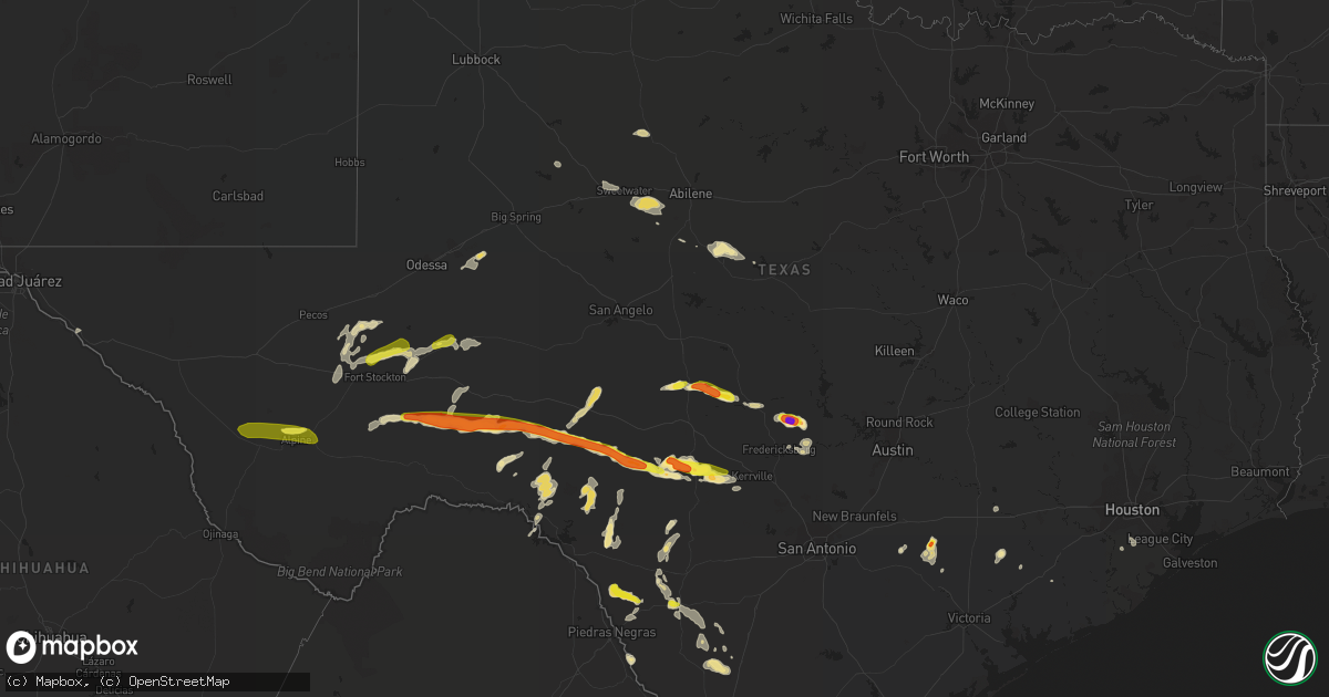
Hail Map in Texas on May 30, 2019
Get this storm
May 30 map
$229
one time, instant access
Download today. No call, no setup
Keep the $229
Bought the map and want the full workflow? Apply the entire $229 to a subscription within 7 days. None of it is wasted.
Every map, not just this one
This buys you this map. Subscription and you get every map we run, in the markets you choose from a few cities to whole states to nationwide. Plus real-time alerts the moment a storm fires.
Contact data
Name, contact info, occupancy, even credit band for addresses in the footprint. You go from where it hit to who to call.
Become the source they trust
Unlimited branding weather history reports on demand. You already have the documented answer ready for the property owner, and you are the one who showed up with it.
Property data and RoofTrace estimates
Pull up any address you have got, its value and the exact code rules for that jurisdiction, straight from One Click Code. Then RoofTrace estimates the squares, pitch, and roof value, priced the way you price.
Storm reports in Texas
Texas
| Date | Description |
|---|---|
| 05/30/20196:30 PM CDT | Picture of 3 inch hail with ruler posted on twitter. Time estimated via radar. |
| 05/30/20196:22 PM CDT | Public report of golf ball size hail. |
| 05/30/20196:07 PM CDT | A local report indicates 1.00 inch wind near 20 S OZONA |
| 05/30/20196:00 PM CDT | A local report indicates 1.00 inch wind near 17 S OZONA |
| 05/30/20195:01 PM CDT | A local report indicates 1.00 inch wind near FORT DAVIS |
| 05/30/20194:53 PM CDT | Trees downed by thunderstorm wind gusts. Time estimated by radar. |
| 05/30/20193:09 PM CDT | A local report indicates 1.00 inch wind near 20 SSW BAKERSFIELD |
| 05/30/201910:33 AM CDT | A local report indicates 1.00 inch wind near 12 N FORT STOCKTON |
| 05/30/20197:42 AM CDT | At 1241 PM CDT, a severe thunderstorm was located over Pandale, or 26 miles north of Langtry, moving northeast at 20 mph. HAZARD...60 mph wind gusts and quarter size hail. SOURCE...Radar indicated. IMPACT...Hail damage to vehicles is expected. Expect wind damage to roofs, siding, and trees. Locations impacted include... Pandale and Hackberry Crossing. |
| 05/30/20197:29 AM CDT | At 1228 PM CDT, a severe thunderstorm was located near Rankin, moving northeast at 45 mph. HAZARD...60 mph wind gusts and quarter size hail. SOURCE...Radar indicated. IMPACT...Hail damage to vehicles is expected. Expect wind damage to roofs, siding, and trees. Locations impacted include... Rankin, Stiles and Best. |
| 05/30/20197:07 AM CDT | At 1206 PM CDT, a severe thunderstorm was located near McCamey, moving east at 40 mph. HAZARD...60 mph wind gusts and quarter size hail. SOURCE...Radar indicated. IMPACT...Hail damage to vehicles is expected. Expect wind damage to roofs, siding, and trees. Locations impacted include... McCamey, Rankin and Upton County Airport. |
| 05/30/20196:58 AM CDT | At 1158 AM CDT, a severe thunderstorm was located 15 miles south of Juno, moving northeast at 25 mph. HAZARD...Quarter size hail. SOURCE...Radar indicated. IMPACT...Damage to vehicles is expected. Locations impacted include... Juno, Bakers Crossing and Devils River SNA - Del Norte. |
| 05/30/20195:37 AM CDT | At 1037 AM CDT, a severe thunderstorm was located 12 miles north of Fort Stockton, moving northeast at 25 mph. HAZARD...60 mph wind gusts and quarter size hail. SOURCE...Radar indicated. IMPACT...Hail damage to vehicles is expected. Expect wind damage to roofs, siding, and trees. Locations impacted include... McCamey, Cordona Lake and Imperial. |
| 05/30/20194:33 AM CDT | At 933 PM CDT, a severe thunderstorm was located near Batesville, moving east at 20 mph. HAZARD...60 mph wind gusts and quarter size hail. SOURCE...Radar indicated. IMPACT...Hail damage to vehicles is expected. Expect wind damage to roofs, siding, and trees. Locations impacted include... Batesville. |
| 05/30/20194:15 AM CDT | At 915 AM CDT, a severe thunderstorm was located 10 miles west of Grandfalls, or 20 miles southwest of Monahans, moving northeast at 15 mph. HAZARD...60 mph wind gusts and half dollar size hail. SOURCE...Radar indicated. IMPACT...Hail damage to vehicles is expected. Expect wind damage to roofs, siding, and trees. Locations impacted include... Grandfalls, Wickett and Royalty. This includes Interstate 20 between mile markers 70 and 73. |
| 05/30/20194:01 AM CDT | At 901 PM CDT, a severe thunderstorm was located over La Pryor, moving north at 15 mph. HAZARD...Quarter size hail. SOURCE...Radar indicated. IMPACT...Damage to vehicles is expected. Locations impacted include... La Pryor, Uvalde Estates and Washer. |
| 05/30/20193:56 AM CDT | A large tree branch was blown down in sweetwater. |
| 05/30/20193:55 AM CDT | The sweetwater awos recorded a wind gust of 64 mph. |
| 05/30/20193:40 AM CDT | At 840 PM CDT, a severe thunderstorm was located 9 miles northeast of Rocksprings, moving east at 15 mph. HAZARD...Quarter size hail. SOURCE...Radar indicated. IMPACT...Damage to vehicles is expected. Locations impacted include... Devil's Sinkhole State Natural Area. |
| 05/30/20193:36 AM CDT | At 836 PM CDT, a severe thunderstorm was located 23 miles west of Persimmon Gap, or 31 miles northeast of Lajitas, moving east at 15 mph. HAZARD...Ping pong ball size hail and 60 mph wind gusts. SOURCE...Radar indicated. IMPACT...People and animals outdoors will be injured. Expect hail damage to roofs, siding, windows, and vehicles. Expect wind damage to roofs, siding, and trees. Locations impacted include... Persimmon Gap, Big Bend National Park, Terlingua Ranch Airport and Terlingua Ranch Lodge. |
| 05/30/20193:28 AM CDT | At 828 PM CDT, a severe thunderstorm was located near La Pryor, moving north at 20 mph. HAZARD...Half dollar size hail. SOURCE...Radar indicated. IMPACT...Damage to vehicles is expected. Locations impacted include... La Pryor and Washer. |
| 05/30/20193:15 AM CDT | At 815 PM CDT, a severe thunderstorm was located 7 miles south of Blewett, or 13 miles northwest of La Pryor, moving north at 20 mph. The main threat from this storm will be damaging thunderstorm winds. HAZARD...70 mph wind gusts and penny size hail. SOURCE...Radar indicated. IMPACT...Expect considerable tree damage. Damage is likely to mobile homes, roofs, and outbuildings. Locations impacted include... Blewett, Cline and Dabney. |
| 05/30/20193:09 AM CDT | At 809 AM CDT, a severe thunderstorm was located near Carta Valley, or near Loma Alta, moving north at 15 mph. HAZARD...60 mph wind gusts and quarter size hail. SOURCE...Radar indicated. IMPACT...Hail damage to vehicles is expected. Expect wind damage to roofs, siding, and trees. Locations impacted include... Loma Alta, Carta Valley and Vinegarone. |
| 05/30/20193:04 AM CDT | At 804 PM CDT, a severe thunderstorm was located near Darling, or 12 miles south of Spofford, moving east at 15 mph. HAZARD...Ping pong ball size hail and 60 mph wind gusts. SOURCE...Radar indicated. IMPACT...People and animals outdoors will be injured. Expect hail damage to roofs, siding, windows, and vehicles. Expect wind damage to roofs, siding, and trees. Locations impacted include... Darling. |
| 05/30/20193:00 AM CDT | At 800 PM CDT, a severe thunderstorm was located near El Indio, moving southeast at 15 mph. HAZARD...Ping pong ball size hail. SOURCE...Radar indicated. IMPACT...People and animals outdoors will be injured. Expect damage to roofs, siding, windows, and vehicles. Locations impacted include... El Indio. |
| 05/30/20192:56 AM CDT | At 756 PM CDT, a severe thunderstorm was located 17 miles northwest of Rocksprings, moving east at 20 mph. HAZARD...Ping pong ball size hail. SOURCE...Radar indicated. IMPACT...People and animals outdoors will be injured. Expect damage to roofs, siding, windows, and vehicles. Locations impacted include... Rocksprings and Devil's Sinkhole State Natural Area. |
| 05/30/20192:55 AM CDT | A local report indicates 62 MPH wind near 1 SW SNYDER |
| 05/30/20192:41 AM CDT | At 741 PM CDT, a severe thunderstorm was located near Darling, or 8 miles south of Spofford, moving northeast at 15 mph. HAZARD...Ping pong ball size hail and 60 mph wind gusts. SOURCE...Radar indicated. IMPACT...People and animals outdoors will be injured. Expect hail damage to roofs, siding, windows, and vehicles. Expect wind damage to roofs, siding, and trees. Locations impacted include... Spofford, Anacacho, Darling and Laughlin AFB Aux Field. |
| 05/30/20192:33 AM CDT | At 733 AM CDT, a severe thunderstorm was located 7 miles south of Juno, moving northeast at 25 mph. HAZARD...60 mph wind gusts and quarter size hail. SOURCE...Radar indicated. IMPACT...Hail damage to vehicles is expected. Expect wind damage to roofs, siding, and trees. Locations impacted include... Juno and Bakers Crossing. |
| 05/30/20192:05 AM CDT | At 705 PM CDT, a severe thunderstorm was located 14 miles southwest of Marathon, or 28 miles southeast of Alpine, moving east at 15 mph. HAZARD...Golf ball size hail. SOURCE...Radar indicated. IMPACT...People and animals outdoors will be injured. Expect damage to roofs, siding, windows, and vehicles. Locations impacted include... Elephant Mountain Wildlife Management Area. |
| 05/30/20192:05 AM CDT | At 705 PM CDT, a severe thunderstorm was located near Darling, or 10 miles south of Spofford, moving east at 15 mph. HAZARD...Quarter size hail. SOURCE...Radar indicated. IMPACT...Damage to vehicles is expected. Locations impacted include... Darling. |
| 05/30/20191:55 AM CDT | At 655 PM CDT, a severe thunderstorm was located 20 miles south of Sonora, moving southeast at 20 mph. HAZARD...Ping pong ball size hail. SOURCE...Radar indicated. IMPACT...People and animals outdoors will be injured. Expect damage to roofs, siding, windows, and vehicles. Locations impacted include... Us-277 Near The Sutton-Edwards County Line. |
| 05/30/20191:38 AM CDT | At 638 AM CDT, a severe thunderstorm was located over Standart, or 12 miles west of Brackettville, moving north at 25 mph. HAZARD...60 mph wind gusts and quarter size hail. SOURCE...Radar indicated. IMPACT...Hail damage to vehicles is expected. Expect wind damage to roofs, siding, and trees. Locations impacted include... Standart, Amanda and Kickapoo Cavern State Park. |
| 05/30/20191:32 AM CDT | At 631 AM CDT, a severe thunderstorm was located 13 miles west of Carta Valley, or 14 miles southwest of Loma Alta, moving north at 20 mph. HAZARD...60 mph wind gusts and quarter size hail. SOURCE...Radar indicated. IMPACT...Hail damage to vehicles is expected. Expect wind damage to roofs, siding, and trees. Locations impacted include... Loma Alta, Devils River SNA - Del Norte, Vinegarone and Devils River SNA - Big Satan. |
| 05/30/20191:30 AM CDT | At 629 PM CDT, a severe thunderstorm was located 16 miles north of Juno, moving east at 20 mph. This is a very dangerous storm. HAZARD...Baseball size hail and 70 mph wind gusts. SOURCE...Radar indicated. IMPACT...People and animals outdoors will be severely injured. Expect shattered windows, extensive damage to roofs, siding, and vehicles. This severe thunderstorm will remain over mainly rural areas of southeastern Crockett and southwestern Sutton Counties, including the following locations... The Intersection Of Us-277 And Ranch Road 189 and Us-277 Near The Sutton-Edwards County Line. |
| 05/30/20191:08 AM CDT | At 608 PM CDT, a severe thunderstorm was located near Enchanted Rock State Natural Area, or 16 miles southwest of Llano, moving east at 15 mph. HAZARD...60 mph wind gusts and half dollar size hail. SOURCE...Radar indicated. IMPACT...Hail damage to vehicles is expected. Expect wind damage to roofs, siding, and trees. Locations impacted include... Kingsland, Round Mountain, Granite Shoals, Horseshoe Bay, Blowout, Enchanted Rock State Natural Area, Eckert, Crabapple, Oxford and Sunrise Beach Village. |
| 05/30/20191:00 AM CDT | At 600 PM CDT, a severe thunderstorm was located near Alpine-Casparis Municipal Airport, or near Alpine, moving east at 15 mph. HAZARD...Quarter size hail. SOURCE...Radar indicated. IMPACT...Damage to vehicles is expected. Locations impacted include... Alpine and Alpine-Casparis Municipal Airport. |
| 05/30/201912:56 AM CDT | At 556 PM CDT, a severe thunderstorm was located over Kerr Wildlife Management Area, or 20 miles north of Vanderpool, moving southeast at 15 mph. HAZARD...Half dollar size hail. SOURCE...Radar indicated. IMPACT...Damage to vehicles is expected. Locations impacted include... Kerr Wildlife Management Area. |
| 05/30/201912:38 AM CDT | At 537 PM CDT, a severe thunderstorm was located near Streeter, or near Mason, moving southeast at 20 mph. HAZARD...Ping pong ball size hail and 60 mph wind gusts. SOURCE...Radar indicated. IMPACT...People and animals outdoors will be injured. Expect hail damage to roofs, siding, windows, and vehicles. Expect wind damage to roofs, siding, and trees. This severe thunderstorm will be near... Mason around 550 PM CDT. Art around 605 PM CDT. Hedwigs Hill around 610 PM CDT. Hilda around 615 PM CDT. Loyal Valley around 630 PM CDT.Other locations impacted by this severe thunderstorm includeKoockville and Us-87 Near The Mason-Gillespie County Line. |
| 05/30/201912:34 AM CDT | At 533 PM CDT, a severe thunderstorm was located near Kerr Wildlife Management Area, or 21 miles north of Vanderpool, moving east at 15 mph. HAZARD...Two inch hail. SOURCE...Radar indicated. IMPACT...People and animals outdoors will be injured. Expect damage to roofs, siding, windows, and vehicles. Locations impacted include... Kerr Wildlife Management Area. |
| 05/30/201912:29 AM CDT | At 529 PM CDT, a severe thunderstorm was located 20 miles southwest of Ozona, moving southeast at 25 mph. This is a very dangerous storm. HAZARD...Baseball size hail and 70 mph wind gusts. SOURCE...Radar indicated. IMPACT...People and animals outdoors will be severely injured. Expect shattered windows, extensive damage to roofs, siding, and vehicles. This severe thunderstorm will remain over mainly rural areas of southeastern Crockett County, including the following locations... The Intersection Of Ranch Road 2083 And Highway 405 and The Intersection Of Highway 163 And Ranch Road 1973. |
| 05/30/201912:21 AM CDT | At 521 PM CDT, a severe thunderstorm was located 12 miles west of Kerr Wildlife Management Area, or 25 miles north of Leakey, moving east at 20 mph. HAZARD...Two inch hail and 60 mph wind gusts. SOURCE...Radar indicated. IMPACT...People and animals outdoors will be injured. Expect hail damage to roofs, siding, windows, and vehicles. Expect wind damage to roofs, siding, and trees. Locations impacted include... Mountain Home and Kerr Wildlife Management Area. |
| 05/30/201912:17 AM CDT | At 517 PM CDT, a severe thunderstorm was located 17 miles southeast of Marfa, moving east at 25 mph. HAZARD...Quarter size hail. SOURCE...Radar indicated. IMPACT...Damage to vehicles is expected. Locations impacted include... Elephant Mountain and Elephant Mountain Wildlife Management Area. |
| 05/30/201912:01 AM CDT | At 500 PM CDT, a severe thunderstorm was located near Bloys Camp, or 11 miles southwest of Fort Davis, moving east at 15 mph. HAZARD...60 mph wind gusts and quarter size hail. SOURCE...Radar indicated. IMPACT...Hail damage to vehicles is expected. Expect wind damage to roofs, siding, and trees. Locations impacted include... Alpine, Fort Davis, Camp Mitre Peak, Alpine-Casparis Municipal Airport, Davis Mountains State Park, Marfa Municipal Airport, Indian Lodge and Fort Davis National Historical Site. |
| 05/30/201912:00 AM CDT | At 459 PM CDT, a severe thunderstorm was located near Saline, or 13 miles southeast of Menard, moving southeast at 15 mph. HAZARD...Ping pong ball size hail and 60 mph wind gusts. SOURCE...Radar indicated. IMPACT...People and animals outdoors will be injured. Expect hail damage to roofs, siding, windows, and vehicles. Expect wind damage to roofs, siding, and trees. This severe thunderstorm will be near... Hext around 510 PM CDT. Saline and London around 520 PM CDT. Long Mountain around 530 PM CDT. Streeter and Grit around 545 PM CDT.Other locations impacted by this severe thunderstorm include TheIntersection Of Highway 29 And Ranch Road 1222, Us-377 Near The Kimble-Menard County Line and Erna. |
| 05/29/201911:59 PM CDT | At 458 PM CDT, a severe thunderstorm was located 15 miles south of Telegraph, or 20 miles east of Rocksprings, moving northeast at 15 mph. HAZARD...Two inch hail and 60 mph wind gusts. SOURCE...Radar indicated. IMPACT...People and animals outdoors will be injured. Expect hail damage to roofs, siding, windows, and vehicles. Expect wind damage to roofs, siding, and trees. This severe thunderstorm will remain over mainly rural areas of west central Kerr and northeastern Edwards Counties. |
| 05/29/201911:57 PM CDT | At 456 AM CDT, a severe thunderstorm was located over Bastrop, moving east at 20 mph. HAZARD...60 mph wind gusts and quarter size hail. SOURCE...Radar indicated. IMPACT...Hail damage to vehicles is expected. Expect wind damage to roofs, siding, and trees. Locations impacted include... Bastrop, Smithville, Camp Swift, Circle D-KC Estates, Upton, Phelan, Bastrop State Park, Hills Prairie, Buescher State Park and Alum Creek. |
| 05/29/201911:36 PM CDT | At 435 PM CDT, a severe thunderstorm was located 12 miles southwest of Telegraph, or 15 miles northeast of Rocksprings, moving northeast at 10 mph. HAZARD...Quarter size hail. SOURCE...Radar indicated. IMPACT...Damage to vehicles is expected. Locations impacted include... Us-377 Near The Kimble-Edwards County Line. |
| 05/29/201911:35 PM CDT | At 434 PM CDT, a severe thunderstorm was located 8 miles north of Terrell County Gas Plant, or 14 miles south of Sheffield, moving east at 20 mph. This is a very dangerous storm. HAZARD...Baseball size hail and 70 mph wind gusts. SOURCE...Radar indicated. IMPACT...People and animals outdoors will be severely injured. Expect shattered windows, extensive damage to roofs, siding, and vehicles. This severe thunderstorm will remain over mainly rural areas of southeastern Crockett County, including the following locations... Ft Lancaster and The Intersection Of Ranch Road 2083 And Highway 405. |
| 05/29/201911:18 PM CDT | At 417 PM CDT, a severe thunderstorm was located 8 miles southwest of Menard, moving east at 20 mph. HAZARD...60 mph wind gusts and quarter size hail. SOURCE...Radar indicated. IMPACT...Hail damage to vehicles is expected. Expect wind damage to roofs, siding, and trees. This severe thunderstorm will be near... Menard around 445 PM CDT.Other locations impacted by this severe thunderstorm include TheIntersection Of Us-83 And Ranch Road 1773, Us-377 Near The Kimble-Menard County Line, The Intersection Of Us-83 And Highway 29 and Us-83 Near The Kimble-Menard County Line. |
| 05/29/201911:15 PM CDT | At 415 PM CDT, a severe thunderstorm was located 9 miles northwest of Terrell County Gas Plant, or 14 miles south of Sheffield, moving east at 35 mph. This is a very dangerous storm. HAZARD...Three inch hail and 70 mph wind gusts. SOURCE...Radar indicated. IMPACT...People and animals outdoors will be severely injured. Expect shattered windows, extensive damage to roofs, siding, and vehicles. Locations impacted include... Terrell County Gas Plant. |
| 05/29/201911:04 PM CDT | At 403 PM CDT, a severe thunderstorm was located near Valentine, or 27 miles northwest of Marfa, moving east at 30 mph. HAZARD...60 mph wind gusts and quarter size hail. SOURCE...Radar indicated. IMPACT...Hail damage to vehicles is expected. Expect wind damage to roofs, siding, and trees. Locations impacted include... Fort Davis, Valentine, Bloys Camp, McDonald Observatory, Davis Mountains State Park, Camp Mitre Peak, Black Mountain, Star Mountain, Indian Lodge and Fort Davis National Historical Site. |
| 05/29/201910:14 PM CDT | At 313 PM CDT, a severe thunderstorm was located 28 miles north of Sanderson, moving east at 30 mph. Trained spotters 20 miles south of Bakersfield have confirmed quarter size hail falling in the storm at 309 PM CDT. HAZARD...60 mph wind gusts and quarter size hail. SOURCE...Trained weather spotters. IMPACT...Hail damage to vehicles is expected. Expect wind damage to roofs, siding, and trees. Locations impacted include... Sheffield, Iraan and Iraan Municipal Airport. This includes Interstate 10 between mile markers 302 and 327. |
| 05/29/20199:47 PM CDT | At 246 PM CDT, a severe thunderstorm was located 10 miles north of Valentine, or 27 miles southwest of Kent, moving northeast at 25 mph. HAZARD...60 mph wind gusts and quarter size hail. SOURCE...Radar indicated. IMPACT...Hail damage to vehicles is expected. Expect wind damage to roofs, siding, and trees. Locations impacted include... Kent, Balmorhea State Park, Buffalo Trail Scout Camp and Toyahvale.This includes the following highways... Interstate 10 between mile markers 169 and 202. Interstate 20 between mile markers 0 and 4. |
| 05/29/20199:44 PM CDT | At 244 PM CDT, a severe thunderstorm was located near Lajitas, moving east at 25 mph. HAZARD...60 mph wind gusts and quarter size hail. SOURCE...Radar indicated. IMPACT...Hail damage to vehicles is expected. Expect wind damage to roofs, siding, and trees. Locations impacted include... Lajitas, Study Butte, Terlingua, Big Bend National Park, Terlingua Ranch Airport, Terlingua Ranch Lodge and Barton Warnock Environmental Educational Center. |
| 05/29/20199:36 PM CDT | At 235 PM CDT, a severe thunderstorm was located 17 miles southeast of Castolon, or 23 miles south of Panther Junction, moving east at 40 mph. HAZARD...60 mph wind gusts and quarter size hail. SOURCE...Radar indicated. IMPACT...Hail damage to vehicles is expected. Expect wind damage to roofs, siding, and trees. This severe thunderstorm will remain over mainly rural areas of south central Brewster County. |
| 05/29/20199:28 PM CDT | At 227 AM CDT, a severe thunderstorm was located over Guadalupe River State Park, or 15 miles northeast of Boerne, moving east at 20 mph. HAZARD...60 mph wind gusts and quarter size hail. SOURCE...Radar indicated. IMPACT...Hail damage to vehicles is expected. Expect wind damage to roofs, siding, and trees. Locations impacted include... Canyon Lake, Guadalupe River State Park, Spring Branch, Smithson Valley, Anhalt, and Honey Creek State Natural Area. |
| 05/29/20199:16 PM CDT | At 216 PM CDT, a severe thunderstorm was located 25 miles south of Fort Stockton, moving east at 25 mph. HAZARD...60 mph wind gusts and quarter size hail. SOURCE...Radar indicated. IMPACT...Hail damage to vehicles is expected. Expect wind damage to roofs, siding, and trees. Locations impacted include... Sierra Madera. |
| 05/29/20198:56 PM CDT | A local report indicates 1.00 inch wind near LA PRYOR |
| 05/29/20197:40 PM CDT | Public report on twitter showing hail covering the ground in northern edwards co along hwy 55. Pictures in tweet show at least 1.25 inch hail and tweet mentions 1.75 in |
All States Impacted by Hail Map on May 30, 2019
Cities Impacted by Hail Map on May 30, 2019
- Newman Lake, WA
- Fredericksburg, TX
- Llano, TX
- Coleman, TX
- Burkett, TX
- Del Rio, TX
- Rocksprings, TX
- Hillsboro, IN
- Kingman, IN
- Bloomingdale, IN
- Pantego, NC
- Roper, NC
- Grifton, NC
- Kinston, NC
- Dover, NC
- Hallettsville, TX
- West Lafayette, IN
- Rapidan, VA
- Unionville, VA
- Orange, VA
- Whitestown, IN
- Mason, TX
- Fort Stockton, TX
- Red Bluff, CA
- Covington, IN
- Mountain Home, TX
- Ijamsville, MD
- West Friendship, MD
- Damascus, MD
- Cooksville, MD
- Adamstown, MD
- Monrovia, MD
- Frederick, MD
- Jefferson, MD
- Buckeystown, MD
- Mount Airy, MD
- Woodbine, MD
- Clarksburg, MD
- Glenwood, MD
- Leakey, TX
- Hunt, TX
- Stonewall, TX
- Sonora, TX
- Eldorado, TX
- Greensboro, MD
- Coyanosa, TX
- Chico, CA
- Corning, CA
- Lebanon, IN
- Comstock, TX
- New Paris, OH
- Lewisville, IN
- Hagerstown, IN
- Markleville, IN
- Cambridge City, IN
- Boston, IN
- Centerville, IN
- New Lebanon, OH
- Lewisburg, OH
- Middletown, IN
- Shirley, IN
- Camden, OH
- Richmond, IN
- Milton, IN
- Falmouth, IN
- Straughn, IN
- New Castle, IN
- West Alexandria, OH
- Eaton, OH
- Brownsville, IN
- Liberty, IN
- Connersville, IN
- Farmersville, OH
- Greens Fork, IN
- Quemado, TX
- Clearlake, CA
- Lower Lake, CA
- Menard, TX
- Westpoint, IN
- Lafayette, IN
- Wingate, IN
- Uvalde, TX
- Biggs, CA
- Oroville, CA
- Gridley, CA
- Johnson City, TX
- Hye, TX
- Aroda, VA
- Somerset, VA
- Ruckersville, VA
- Fredericksburg, VA
- Spotsylvania, VA
- Rochelle, VA
- Barboursville, VA
- Rhoadesville, VA
- Locust Grove, VA
- Forbestown, CA
- Strawberry Valley, CA
- Bristow, VA
- Fairfax, VA
- Catharpin, VA
- Fairfax Station, VA
- Gainesville, VA
- Clifton, VA
- Broad Run, VA
- Haymarket, VA
- Centreville, VA
- The Plains, VA
- Manassas, VA
- Brackettville, TX
- Goodfield, IL
- Eureka, IL
- Congerville, IL
- Deer Creek, IL
- Sweetwater, TX
- Nolan, TX
- Merkel, TX
- Dryden, TX
- Ozona, TX
- Gonzales, TX
- Jamestown, IN
- Faison, NC
- Mount Olive, NC
- Warsaw, NC
- Roscoe, TX
- Crystal City, TX
- Willows, CA
- Orland, CA
- Glenn, CA
- London, TX
- Berry Creek, CA
- Sprague, WA
- Mulberry, IN
- Frankfort, IN
- Michigantown, IN
- Bath, NC
- Washington, NC
- Pinetown, NC
- Chocowinity, NC
- Big Wells, TX
- Asherton, TX
- Ingram, TX
- Challenge, CA
- Snyder, TX
- Colville, WA
- Arnold, MD
- Gibson Island, MD
- Reva, VA
- Vanceboro, NC
- Ayden, NC
- Attica, IN
- Danville, IL
- Williamsport, IN
- Bismarck, IL
- State Line, IN
- Veedersburg, IN
- Kokomo, IN
- Converse, IN
- Miami, IN
- Greentown, IN
- Bunker Hill, IN
- Amboy, IN
- Galveston, IN
- Walton, IN
- Whitleyville, TN
- Moss, TN
- Willow City, TX
- Sheffield, TX
- Iraan, TX
- Cost, TX
- Laredo, TX
- Midland, TX
- Crawfordsville, IN
- Lizton, IN
- Brownsburg, IN
- Pittsboro, IN
- North Salem, IN
- Forest Ranch, CA
- Magalia, CA
- Paradise, CA
- Trenton, NC
- Cutler, IN
- Rossville, IN
- Radiant, VA
- Pioche, NV
- Secor, IL
- Marshall, IN
- Batesville, TX
- Hamilton City, CA
- Columbia, NC
- Milford, DE
- Charlottesville, IN
- Knightstown, IN
- Greenfield, IN
- Tuscola, TX
- La Pryor, TX
- Cuero, TX
- Battle Ground, IN
- Camptonville, CA
- Alpine, TX
- Northport, WA
- McCamey, TX
- Brownwood, TX
- Polson, MT
- Celina, TN
- Hamlin, TX
- Arrowsmith, IL
- Saybrook, IL
- Grandfalls, TX
- Pecos, TX
- Fairmount, IN
- Jonesboro, IN
- Hartford City, IN
- Gas City, IN
- Upland, IN
- Dexter, NM
- Hagerman, NM
- Weimar, TX
- La Grange, NC
- Hookerton, NC
- Cove City, NC
- Seven Springs, NC
- Grimesland, NC
- Deep Run, NC
- Jenkins, KY
- Queen Anne, MD
- Ridgely, MD
- Harrington, DE
- Felton, DE
- Chattaroy, WA
- Roseboro, NC
- Salemburg, NC
- Autryville, NC
- Republic, WA
- Greenwood, DE
- Lincoln, DE
- Goldsboro, MD
- Milton, DE
- Centreville, MD
- Houston, DE
- Eagle Pass, TX
- Yoakum, TX
- Shiner, TX
- New Ross, IN
- Davenport, WA
- House, NM
- Cotulla, TX
- Elk, WA
- Clinton, NC
- Imperial, TX
- Middletown, MD
- Gaithersburg, MD
- Brookeville, MD
- Braddock Heights, MD
- Glenelg, MD
- Plymouth, NC
- Novice, TX
- Swayzee, IN
- Cheney, WA
- Ernul, NC
- Valley, WA
- Moscow, ID
- Midkiff, TX
- Rushville, IN
- Oregonia, OH
- Clarksville, OH
- Calypso, NC
- Brookston, IN
- Kettle Falls, WA
- El Campo, TX
- Winterville, NC
- Greenville, NC
- Louise, TX
- Marion, IN
- Otterbein, IN
- Medina, TX
- Mitchells, VA
- Culpeper, VA
- Columbus, TX
- Gifford, WA
- Fort Hancock, TX
- Waynesville, OH
- Nixon, TX
- Rosharon, TX
- Belhaven, NC
- Greenville, OH
- Junction, TX
- Bellflower, IL
- Foosland, IL
- Kerrville, TX
- Winters, TX
- Manvel, TX
- Hext, TX
- Marfa, TX
- Marathon, TX
- Fort Davis, TX
- Valentine, TX
- New Market, MD


